Systematic Review

Century-Scale Earth Observation: Systematic Review of Georeferencing Methods for Historical Aerial and Satellite Imagery


Department of Geography, University of Florida, Gainesville, FL 32611, USA
*
Author to whom correspondence should be addressed.
Remote Sens. 2026, 18(7), 1052; https://doi.org/10.3390/rs18071052
Submission received: 16 January 2026 / Revised: 27 March 2026 / Accepted: 30 March 2026 / Published: 1 April 2026

Highlights

What are the main findings?
  • Despite advances in algorithmic processing, georeferencing historical images remains bottlenecked by a heavy reliance on manual and partially automated workflows due to inherently incomplete metadata and uncertain acquisition geometries.
  • Ground control points persistently dictate the geometric constraints of historical imagery, exposing a critical void in fully automated methodologies that operate independently of these points and can adapt to complex landscape changes.
  • Accuracy assessment practices are fundamentally inconsistent across the literature, as most studies report control-point residuals rather than independent checkpoint validation, and reporting conventions range from quantitative RMSE to qualitative visual inspection, critically undermining cross-study comparability and the cumulative scientific value of georeferenced historical archives.
What are the implications of the main findings?
  • A New Methodological Paradigm: Georeferencing historical data can no longer be treated as a simplified secondary stage of modern photogrammetry. These findings imply that it should be recognized as a distinct methodological domain requiring workflows designed specifically for structural uncertainty, sensor heterogeneity, and severe temporal landscape transformations.
  • A Shift in Validation and Reporting: The current inconsistency in accuracy assessment is a massive liability. The implication here is that the field must pivot toward evaluations that account for uncertainty and validation driven by specific applications. We need mandatory transparent workflow reporting that relies on independent checkpoints rather than just residual values from control points, ensuring datasets are fit for their intended scientific purpose.
  • As the first PRISMA-compliant synthesis of historical georeferencing practices, this review establishes an empirical baseline that can directly inform the development of standardized validation protocols, guide the integration of emerging deep learning and vision foundation model approaches, and prioritize capacity building in geographically underrepresented regions where pre-satellite environmental baselines are most urgently needed.

Abstract

Historical remote sensing imagery, including archival aerial photographs and declassified satellite imagery, has been increasingly used to extend earth observation records into periods not covered by modern satellite missions. However, the broader application of these data remains constrained by georeferencing challenges related to incomplete metadata, uncertain acquisition geometry, and heterogeneous image characteristics. This systematic review examines georeferencing practices for historical remote sensing imagery. Out of the 2547 studies identified in the literature, 205 peer-reviewed journal articles were deemed eligible for analysis. This systematic review provides the first comprehensive, PRISMA-compliant synthesis of georeferencing practices for historical remote sensing imagery, analyzing 205 peer-reviewed studies to establish methodological patterns and identify critical gaps. The review considers imagery types, spatial and temporal distributions of case studies, georeferencing workflows, geometric constraints, and accuracy reporting practices. The results indicate a strong reliance on ground control points and a clear preference for manual or semi-automatic georeferencing approaches, while fully automatic methods remain rare. Although the use of historical imagery has increased over time, its potential has not been fully exploited due to persistent georeferencing difficulties, and study areas are often spatially limited or selectively processed to achieve acceptable accuracy. Nevertheless, properly georeferenced historical imagery has been widely applied to land-cover analysis, geomorphology, cryosphere research, hazard assessment, and archeology by extending observation records into earlier decades.

1. Introduction

Over the past several decades, earth observation research has relied primarily on satellite-based remote sensing datasets to characterize land surface conditions and their changes at regional to global scales [1,2]. In practice, the satellite records utilized for quantitative and comparative environmental studies are generally limited to the post-1980s era, following the advent of consistently processed and radiometrically reliable Landsat imagery [3,4,5]. Consequently, land surface conditions from earlier periods remain underrepresented in standard earth observation analyses [6,7]. This limitation makes it difficult to evaluate contemporary environmental change against earlier baseline conditions or to place current observations within a longer historical context [7,8]. Extending spatial observations into earlier decades is therefore critical for several Earth observation applications, including the establishment of pre-satellite environmental baselines, long-term land-use and land-cover change analysis, and the monitoring of gradual environmental processes such as glacier retreat, wetland loss, and coastal erosion, which often unfold over timescales exceeding the available satellite record. To bridge this observational gap, historical remote sensing imagery, including early satellite photographs and archival aerial images, provides essential spatial information required to extend the observation record into the pre-satellite era [9,10].
Historical remote sensing imagery was acquired using a variety of platforms and sensors prior to the widespread adoption of modern digital satellite systems, resulting in notable differences in image characteristics and acquisition geometry [11]. These historical datasets can be broadly categorized into archival aerial photographs, early civilian satellite imagery, and declassified reconnaissance satellite photographs, reflecting successive stages in the development of remote sensing technology [12,13]. Archival aerial photographs often extend back to the early twentieth century and provide high spatial detail suitable for fine-scale landscape analyses [14,15]. Early civilian satellite missions expanded observational capabilities beyond the spatial limitations of aerial surveys, while declassified reconnaissance imagery further enabled near-global coverage at high spatial resolutions [16,17,18]. Collectively, these diverse data sources extend spatial observation coverage into periods otherwise inaccessible via modern satellite missions [13,15,19,20]. Despite their immense potential for long-term monitoring, these historical datasets present significant technical challenges [21,22]. In particular, inherent differences in sensor characteristics and acquisition conditions introduce substantial geometric inconsistencies that complicate their seamless integration with contemporary geospatial datasets [23,24].
During the early stages of remote sensing development, imaging technologies, sensor calibration, and geometric modeling had not yet fully matured, and standardized acquisition protocols were often lacking [25,26]. As a consequence, many historical datasets were collected without comprehensive or consistently documented metadata, including detailed sensor specifications, platform orientation, acquisition geometry, and accurate ground reference information [27,28]. These limitations are further compounded by the use of film-based sensors, non-nadir viewing configurations, and heterogeneous acquisition conditions across platforms and time periods, which introduce complex and spatially variable geometric distortions [29,30,31]. In contemporary earth observation workflows, these factors introduce significant uncertainty in the spatial positioning and geometric consistency of features derived from historical imagery [32]. In modern photogrammetric and remote sensing workflows, comparable geometric uncertainties are typically resolved through rigorous reconstruction methods such as aerial triangulation, bundle adjustment, and increasingly through direct georeferencing systems integrating GPS–IMU or LiDAR technologies [33,34,35]. These approaches rely on well-documented sensor models, calibration parameters, and accurate positioning information [36,37]. However, for many digitized historical photographs, camera orientation parameters and other acquisition information are no longer available [38,39]. In such cases, georeferencing cannot rely on a complete photogrammetric sensor model and instead must be performed by estimating a geometric transformation between image coordinates and ground reference data [40,41]. From the perspective of image registration theory, this process can be viewed as aligning images acquired at different times or by different sensors through the estimation of a spatial transformation between corresponding features [42,43]. Although the underlying geometric principles remain consistent with established photogrammetric practices, the absence of complete sensor metadata and the heterogeneous characteristics of historical imagery often make the georeferencing workflow more complex in practice. Consequently, the direct application of modern photogrammetric reconstruction frameworks to historical datasets is often infeasible. This limitation complicates the integration of historical imagery with contemporary geospatial datasets [44,45]. Under these conditions, the effective use of historical imagery depends critically on establishing reliable spatial reference and geometric alignment, particularly through retrospective georeferencing strategies tailored to incomplete archival data [20,46].
In historical remote sensing applications, georeferencing assigns archival imagery an explicit spatial reference and enables its integration into spatially explicit Earth observation analyses. It is typically performed as the initial step in the processing workflow, particularly when complete sensor models, calibration reports, or direct positioning information are unavailable [47,48]. Through this process, relationships between image coordinates and real-world geographic locations are established, allowing geometric distortions to be corrected and historical images to be positioned within a common spatial reference framework [49,50]. This alignment enables observations acquired at different times, from different platforms, and with different sensors to be compared and combined with modern geospatial datasets [51,52]. It is critical for long-term Earth observation applications, as georeferencing uncertainty can bias land-use and land-cover change analysis, environmental monitoring, and the reconstruction of pre-satellite baselines. Unlike comprehensive photogrammetric reconstruction, which relies on fully parameterized sensor models and orientation solutions, georeferencing in historical remote sensing studies generally involves the post hoc alignment of archival imagery to contemporary coordinate reference systems using ground control points, feature-based matching, or transformation models [8,53]. In practice, georeferencing can be particularly challenging for early aerial photographs and analogue imagery that have been digitized from archival film [22,54,55]. In such cases, metadata may be incomplete, unavailable, or poorly preserved, and sensor geometry may be poorly documented or unknown [56,57]. Additional geometric distortions may also arise during film digitization or scanning processes, particularly when non-photogrammetric scanning methods are used [40,58,59]. Consequently, georeferencing workflows often differ substantially depending on image type and data availability, including differences in assumptions, reference data sources, and levels of user intervention [48]. Such variations in spatial accuracy can propagate into downstream analyses, potentially biasing change detection, area estimates, and long-term environmental reconstructions [60]. The choice and rigor of georeferencing methodology is therefore not merely a preprocessing consideration but a determinant of scientific validity in long-term Earth observation studies. Despite the increasing use of historical imagery, georeferencing practices remain highly heterogeneous across case studies and imagery types [8]. Most studies are application-driven and context-specific, with limited systematic comparison of workflow configurations, geometric constraints, automation levels, and accuracy reporting approaches [4,61,62]. As a consequence, methodological patterns and commonly reported limitations are often discussed only within individual case studies [53,56,57]. Systematic synthesis of georeferencing practices across different imagery types and application contexts remains limited.
In this study, we present a comprehensive review of georeferencing approaches for historical remote sensing imagery, focusing on how spatial challenges specific to historical data have been addressed in existing research. The review considers a wide range of historical imagery types and acquisition contexts, highlighting how differences in image characteristics and data availability influence georeferencing strategies. Existing approaches are organized according to their methodological foundations, with emphasis on distinctions in assumptions, reference data usage, automation levels, and achievable geometric accuracy. Common sources of uncertainty and methodological limitations are examined to clarify how these factors affect the reliability of subsequent earth observation analyses. This review aims to provide a structured synthesis of existing georeferencing practices for historical remote sensing imagery and to inform methodological choices for robust spatial integration of archival imagery, and ultimately to support more reliable reconstruction of long-term environmental change, pre-satellite baseline establishment, and multi-temporal land surface analysis.

2. Methods

This systematic literature review was conducted in accordance with the Preferred Reporting Items for Systematic Reviews and Meta-Analyses (PRISMA) 2020 guidelines [63]. The review protocol was not registered. This review was conducted following a structured systematic review framework [64,65]. A scientific literature database was queried, and explicit eligibility criteria were established prior to study selection. Identified records were subsequently screened and assessed against these criteria, after which the included studies were subjected to a structured analytical procedure. The PRISMA 2020 [63] framework was used to guide transparent reporting of the review process, ensuring that study identification, selection, and synthesis decisions were documented in a clear and reproducible manner. An overview of the review workflow and study selection process is provided in Figure 1.

2.1. Search Strategy and Data Sources

Our study used the Web of Science Core Collection as the sole bibliographic database. This database was selected because it provides strong coverage of peer-reviewed journals in remote sensing, photogrammetry, geosciences, and related interdisciplinary fields, while also offering standardized metadata and Application Programming Interface (API)-based access that support transparent and reproducible literature retrieval. The literature search was conducted programmatically through the Web of Science API within the R environment to ensure a systematic and reproducible retrieval process. The search strategy was designed to identify studies addressing historical remote sensing imagery in conjunction with georeferencing and geometric correction procedures. Article titles, abstracts, and author keywords were queried using a structured search composed of two thematic components. The first component targeted historical, aerial, and declassified imagery, including terms related to historical imagery, historical aerial photographs, declassified imagery, and major declassified satellite missions (CORONA, ARGON, LANYARD, HEXAGON, and GAMBIT). The second component focused on georeferencing and orthorectification procedures and included terms related to georeferencing, orthorectification, orthophotos, and orthoimages. These two components were combined using the logical operator AND to ensure that retrieved records addressed both historical imagery and georeferencing-related aspects. Wildcard symbols (*) and quotation marks were applied where appropriate to capture variant word forms and reduce ambiguous matches identified during preliminary searches. The search was limited to peer-reviewed journal articles indexed in the Web of Science, with no lower limit on publication year and an upper limit of 2025. The complete Web of Science search query and automated retrieval procedure are provided in Supplementary File S1, which contains the exact query syntax used for literature retrieval through the Web of Science API. Duplicate record identification and removal were performed using a dedicated R script provided in Supplementary File S2, ensuring transparency and reproducibility in data preparation. Although this strategy supported retrieval consistency and reproducibility, it may have excluded relevant studies not indexed in the Web of Science Core Collection.

2.2. Study Screening and Eligibility

After retrieval, all records were screened in a stepwise manner to identify studies relevant to the scope of this review. First, duplicate records were identified and removed using an R-based deduplication procedure. Second, titles and abstracts were screened against predefined eligibility criteria. At this stage, records were excluded if they did not involve historical remote sensing imagery, did not address georeferencing, orthorectification, or related geometric correction procedures, or were clearly outside the methodological scope of this review. The full texts of the remaining studies were then assessed for eligibility. Full-text screening focused on whether the study explicitly used historical aerial imagery or declassified satellite imagery and whether the georeferencing or orthorectification procedure was described in sufficient methodological detail to support extraction and coding. Studies were excluded at this stage if they relied only on already georeferenced image products, lacked direct methodological discussion of georeferencing procedures, or did not provide sufficient information to support structured coding. The final included studies therefore comprised publications that explicitly addressed the methodological practice of georeferencing historical remote sensing imagery. Screening was conducted by one reviewer using predefined eligibility criteria. To improve consistency, the eligibility criteria were formalized and pilot-tested on a subset of records prior to full screening, which helped clarify the application of inclusion and exclusion rules before the main screening procedure began. Uncertain cases were re-examined through repeated full-text checking, and decisions on borderline studies were made in consultation with co-authors before final inclusion decisions were reached.

2.3. Data Extraction and Coding Framework

We systematically coded each included study using a structured extraction protocol designed to capture the main contextual and methodological characteristics of the reviewed studies. The coding framework was organized into several analytical domains, including study context, georeferencing workflow characteristics, geometric constraint structures, and broader research applications and temporal patterns represented in the literature. The study context domain recorded the types of historical imagery used, the geographic distribution of case studies, and the temporal coverage of the datasets. The georeferencing workflow domain documented the geometric transformation models employed and the reported level of automation in the georeferencing procedures. Automation levels were coded as manual, semi-automatic, or automatic according to the extent to which ground control point identification and transformation estimation were performed by human operators or supported by algorithmic procedures. The geometric constraint domain captured the constraints used to estimate geometric transformations, including ground control points (GCPs), digital elevation models (DEMs), and sensor metadata. The application and temporal domain recorded the research application areas of historical imagery and the publication year of each study to examine temporal patterns in the literature.
Data extraction and coding were conducted by one reviewer using a structured extraction table and a predefined coding framework. To improve consistency, the coding framework and variable definitions were established prior to full coding. Ambiguous coding cases were revisited through repeated full-text checking and discussed with co-authors before final coding decisions were made. Variables were recorded only when explicitly reported or directly identifiable in the source studies. When information was missing, ambiguous, or insufficiently specified, conservative coding rules were applied and such information was recorded as absent rather than inferred. Formal risk-of-bias assessment tools were not applied because this review did not aim to estimate effect sizes or compare quantitative outcomes, but rather to synthesize methodological practices in historical image georeferencing. Given the substantial heterogeneity in imagery types, reference data availability, validation strategies, and reporting conventions, standardized bias scoring was not considered appropriate for this review. Instead, potential sources of bias and uncertainty were addressed through conservative coding and structured comparative synthesis. All coded data were managed in structured databases and analyzed in R (version 4.5.1). Visualizations were produced using ggplot2, UpSetR for constraint pattern analysis, and networkD3 for Sankey diagrams [66,67,68]. ggplot2 was used to generate standard statistical graphics, including bar charts and temporal distribution plots. UpSet diagrams were used to represent intersection patterns among multiple geometric constraint types, allowing complex combinations of constraints reported in the literature to be displayed clearly. Sankey diagrams were used to visualize the distribution and linkage relationships between imagery sources and research application domains. In this context, the Sankey diagram represents categorical linkages rather than temporal flows, with the width of each connection indicating the number of studies associated with each imagery–application pairing.

2.4. Study Selection Results

The literature search conducted in the Web of Science database using the predefined queries returned a total of 2547 peer-reviewed journal articles. Following the initial retrieval, duplicate records were identified and removed, resulting in 2546 unique articles for subsequent screening. These records were then screened based on their titles, abstracts, and author keywords to assess their relevance to historical remote sensing imagery and georeferencing-related methodologies. After the initial screening, 352 articles were retained for full-text assessment. A detailed examination of the full texts led to the exclusion of studies that did not involve historical imagery, lacked explicit descriptions of georeferencing or orthorectification procedures, or provided insufficient methodological detail. Ultimately, 205 articles met all inclusion criteria and were retained for analysis in this review. The final corpus consists exclusively of peer-reviewed journal articles that directly address the georeferencing of historical remote sensing imagery.

3. Results

3.1. Empirical Context of Historical Imagery Georeferencing

Across the reviewed corpus, historical imagery used for georeferencing falls primarily into two categories: historical aerial imagery and declassified satellite imagery such as CORONA, ARGON, and HEXAGON [69,70,71]. Figure 2 summarizes the usage shares of these imagery types across the reviewed studies. Historical aerial imagery constitutes the majority with 174 studies, accounting for 83.9% of the reviewed cases, whereas declassified satellite imagery contributes 33 studies, representing 16.1%. Within the declassified subset, CORONA dominates with 22 studies (66.7%), followed by ARGON with 6 studies at 18.2% and HEXAGON with 5 studies (15.1%). Overall, the results show that most reported georeferencing practices rely on aerial photograph archives, which constitute the dominant imagery source across the reviewed studies [22,72,73,74]. By contrast, declassified missions represent a smaller portion of the reviewed corpus. Nevertheless, their importance extends beyond their numerical share because they provide systematic, national-scale historical observations, broad spatial coverage, and access to critical pre-Landsat imagery. These features make declassified satellite imagery particularly valuable for extending Earth observation records and supporting long-term historical landscape reconstruction.
The reviewed studies exhibit broad geographic coverage, with study areas spanning multiple continents (Figure 3). The United States constitutes the largest national share with 38 studies [50,75], followed by Italy with 24 [76,77] and Spain with 14 [78,79]. Beyond these leading contributors, the spatial distribution reveals a pronounced concentration across Europe [80,81,82] and North America [83], with sparser representation across Asia [84,85], Oceania [86,87], and parts of Africa [88,89]. Coverage extends into high-latitude environments [14,90], confirming that historical imagery georeferencing has been applied across a wide range of geographic and climatic settings beyond the mid-latitudes. Nevertheless, many countries contribute only one or two studies, and tropical regions and much of the Southern Hemisphere remain substantially underrepresented. The evidence base is therefore global in scope but markedly uneven in geographic density. This imbalance likely reflects, at least in part, differences in data availability, archival access, and the extent of digitization efforts across regions. Europe and North America generally have longer-established aerial survey programs, more accessible archival infrastructures, and broader availability of supporting reference data, all of which lower the practical barriers to historical image georeferencing. By contrast, the limited representation of Asia, Africa, and tropical regions suggests that current methodological patterns may be disproportionately shaped by evidence from data-rich, temperate settings. This uneven representation has important implications for interpretation, because the workflow choices, constraints, and reported performance documented in the literature may not fully capture the challenges of georeferencing historical imagery in underrepresented regions with different environmental conditions, archival histories, and reference data limitations.
The temporal footprint of imagery used in the reviewed studies spans more than a century, extending from <1900s to the 2020s (Figure 4). Figure 4 presents decade-level coverage at the study scale and shows which decades of imagery each paper incorporated. The distribution is anchored in pre-1980 decades, with the 1930s–1960s appearing most frequently across studies [91,92]. Earlier decades are comparatively rare [93,94,95]. The <1900s category occurs only sporadically, and the earliest reported imagery dates back to the 1850s [96]. Later decades after the 1980s appear less consistently in the matrix and mainly extend the record forward into the 2000s–2020s [97,98]. At the level of study design, multi-decade configurations are common, and the decade blocks are often separated by gaps, indicating that many studies assemble selective temporal snapshots rather than a continuous decade-by-decade record [99,100,101]. Beyond the decade aggregation shown here, many papers report imagery dates at finer granularity, such as specific acquisition years or multiple image dates within the same decade, which underlies the decade-level synthesis used in this review [102].

3.2. Geometric Transformation Models and Geometric Constraints

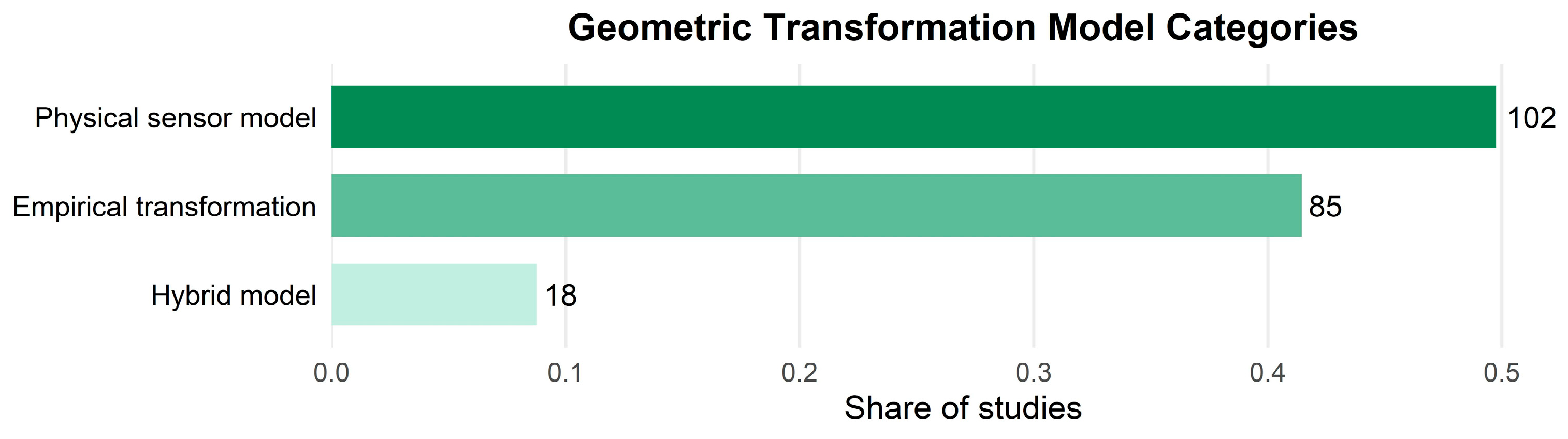
Across the reviewed literature, three types of geometric transformation models are reported in historical image georeferencing (Figure 5): physical sensor models, empirical transformation models, and hybrid implementations that combine elements of both approaches. These models define the mathematical relationship used to transform image coordinates into ground-based coordinate systems [103,104]. Physical sensor models represent the most frequently reported category, appearing in 102 studies [105,106]. These models describe image geometry through physically based sensor parameters and photogrammetric formulations. Empirical transformation models constitute the second most common category and are documented in 85 studies [107,108]. In these approaches, the transformation between image and ground coordinates is estimated directly from ground control points without explicitly reconstructing the original sensor geometry. Hybrid implementations that combine physical sensor modeling with empirical transformations are reported in only 18 studies [56,109].
In addition to transformation models, the reviewed studies report several types of geometric constraints used to estimate these transformations (Figure 6). The following analysis summarizes the constraint information explicitly reported in the reviewed studies and extracted through the coding procedure. Three main types of geometric constraints were identified in the reported literature: ground control points (GCPs), digital elevation models (DEM), and sensor metadata. Among the reported cases, GCPs appear in 169 studies, DEM in 107 studies, and sensor metadata in 93 studies [110,111,112]. In addition, 19 studies did not report sufficient information to classify the constraint structure [113,114]. The reported constraints occur in several combinations across individual georeferencing workflows (Figure 6). The most frequently reported constraint combination integrates GCPs, DEM, and sensor metadata and is documented in 71 studies [115,116,117]. A second commonly reported configuration relies on GCPs only and occurs in 62 studies [118,119]. Other reported combinations include GCPs with DEM (20 studies) and GCPs with sensor metadata (16 studies) [120,121,122]. Configurations reported without GCPs are comparatively uncommon, including DEM with sensor metadata (5 studies), DEM-only configurations (11 studies), and sensor-metadata-only implementations (1 study). These counts summarize the constraint structures reported in the reviewed papers rather than complete operational workflows, because some studies did not fully specify all constraint sources used during georeferencing [123,124]. In several studies classified as DEM-only, DEMs were explicitly reported as terrain reference data, whereas other potential constraints were not described in sufficient detail to be coded [125,126,127].

3.3. Utilization of Georeferencing Outcomes Across Research Themes

Accuracy validation practices vary substantially across the reviewed studies. Positional error metrics derived from control information are frequently reported, with root mean square error and related measures appearing most often [128,129,130,131]. However, the basis of these metrics differs across studies. In many cases, reported errors correspond to residuals at ground control points used during georeferencing, whereas fewer studies report accuracy estimates derived from independent check points [54,132]. Because residuals at ground control points are calculated using the same points that constrain the georeferencing solution, they typically represent internal fitting errors rather than independent validation of positional accuracy [133,134,135]. Consequently, residual-based metrics may underestimate the true spatial error compared with validation based on independent check points [136,137,138]. This difference in validation strategy limits the direct comparability of reported positional accuracy values across studies [139,140]. Beyond differences in validation strategy, reporting practices also vary widely across the literature. Alongside numerical metrics, qualitative reporting is also common, including visual inspection of spatial alignment with reference datasets or brief descriptive statements confirming acceptable correspondence [52,141,142]. Differences are also evident in the level of detail with which accuracy information is reported. Some studies report numerical error values together with descriptions of the geometric information used during georeferencing, whereas others provide limited numerical detail or rely primarily on qualitative confirmation of spatial alignment [143,144]. Reporting detail also appears to be associated with workflow complexity. Studies employing multiple sources of geometric information, such as combinations of ground control points, digital elevation models, and camera models, often report accuracy information alongside these inputs [53,57,145]. In contrast, studies based on simpler configurations more frequently omit explicit numerical metrics or restrict reporting to brief descriptive statements [61,146].
Figure 7 presents a Sankey diagram showing the categorical mapping of reviewed studies between data sources and scientific applications. It provides an overview of how different imagery types are distributed across research themes. Methodological studies constitute the largest category, accounting for 37 studies (18% of the reviewed literature). These studies primarily focus on the technical processing of historical imagery itself, particularly the development and evaluation of georeferencing approaches and related preprocessing workflows. Among the application-oriented studies, coastal research represents the largest thematic group, accounting for over 15% of the total (n = 34). In contrast, geomorphological and fluvial studies occur less frequently, with 18 and 15 studies, respectively, each accounting for less than 10% of the reviewed literature [55,147,148]. Several other research domains show broadly comparable study volumes. Ecosystem-related and cryosphere studies each account for nearly 14% of the reviewed literature, with 29 and 28 studies, respectively [149,150,151]. Land-use and land-cover studies account for 11.2% of the reviewed literature, while archeological applications represent 10.2% [152,153,154]. Imagery types also differ in their distribution across research domains. Historical aerial imagery appears across a wide range of research themes, including coastal, ecosystem, land-use, and geomorphological studies [155,156,157]. Declassified satellite imagery is represented across multiple research domains, but most studies are concentrated in methodological research [158,159,160]. Archeological and cryosphere-related studies also account for a notable share, whereas applications in other domains remain limited [161,162]. No studies based on declassified satellite imagery were identified in fluvial research, and only single-digit studies were identified in coastal, land-use, and ecosystem-related applications.

3.4. Temporal Trends in Georeferencing Practice

The reviewed studies span the period from 1999 to 2025 (Figure 8), with a total of 205 studies included. Overall, the number of publications exhibits a clear increasing trend over time. Prior to 2010, annual publication counts remained low, with most years reporting fewer than five studies and isolated peaks in approximately 2002, 2006, and 2009. From 2010 onward, annual publication counts increased steadily, with a more pronounced rise after 2015, when annual counts consistently exceeded ten studies. A substantial share of the reviewed literature was published between 2018 and 2023. This shift from isolated peaks to sustained publication output after 2015 reflects a consolidation of research activity in historical image georeferencing.
The temporal distribution of georeferencing workflow automation levels is summarized across five-year publication intervals in Figure 9. In the earliest interval (1995–2000, n = 3), all studies used manual workflows. Semi-automatic workflows first appeared in the 2001–2005 interval (n = 16), representing approximately 25% of studies in that period, while manual workflows remained dominant. In the 2006–2010 interval (n = 31), the share of semi-automatic workflows increased to approximately 40%, approaching parity with manual workflows. Fully automatic workflows were not reported. From 2011 to 2015 (n = 31), semi-automatic workflows became the most frequently reported approach, exceeding manual workflows. Fully automatic workflows appeared for the first time, accounting for fewer than 5% of studies. In the 2016–2020 interval (n = 62), semi-automatic workflows dominated, accounting for more than 60% of studies. Manual workflows declined to approximately 35%, while automatic workflows remained below 5%. In the most recent period (2021–2025, n = 62), semi-automatic workflows remained the most common (approximately 50%). However, manual workflows regained a substantial share (approximately 45%), resulting in a more balanced distribution. Fully automatic workflows, first reported from 2015 onward, consistently accounted for a small minority across all subsequent periods [22,53,56,57].
Across the full reviewed corpus, semi-automatic workflows were the most frequently reported configuration (n = 112), followed by manual workflows (n = 89) (Figure 10). Fully automatic georeferencing pipelines were reported in only four studies (Figure 10), all based on declassified satellite imagery [163,164]. This distribution indicates that, over the period 1999–2025, human involvement remained integral to most georeferencing workflows. Most workflows retained manual steps in GCP collection, correspondence verification, mismatch removal, and final transformation implementation [165,166,167]. The prevalence of GCP-based constraint structures, often combined with DEM integration and sensor metadata, is consistent with this pattern of partial rather than end-to-end automation [53,56]. The increased share of manual workflows in the 2021–2025 period suggests that operator verification remains important when processing imagery with variable radiometric quality or incomplete metadata [22].

4. Discussion

4.1. Structural Characteristics of the Historical Image Georeferencing Problem

The literature consistently indicates that georeferencing historical remote sensing imagery constitutes a different problem from that encountered in modern remote sensing workflows [168,169,170]. This difference arises primarily from the inherent incompleteness of historical imagery at the data level [171,172]. Contemporary satellite systems are designed as standardized measurement platforms, in which sensor geometry, platform position, acquisition time, and calibration parameters are explicitly recorded and distributed as integral components of the data product [173,174]. These characteristics provide a well-defined geometric basis for systematic spatial correction and integration. Historical imagery, in contrast, whether derived from early aerial photography or declassified reconnaissance satellites, was typically acquired to meet short-term reconnaissance or mapping objectives rather than long-term geospatial interoperability [175,176].
A defining feature of historical image georeferencing is the presence of multiple, interrelated data constraints that shape the range of feasible solutions. Historical images are frequently associated with incomplete or inconsistent metadata, limiting the reliable identification of acquisition parameters such as platform trajectory, camera configuration, image orientation, and timing [177,178]. In addition, many historical datasets originate from non-metric cameras or film-based imaging systems whose internal geometry was neither stable nor systematically documented, rendering assumptions commonly used in modern sensor models inapplicable [179,180]. Temporal separation further exacerbates these constraints, as landscapes recorded decades earlier often exhibit substantial natural or anthropogenic transformation, reducing the availability of persistent features that can support unambiguous spatial correspondence [181,182,183]. Historical imagery also exhibits pronounced platform heterogeneity, reflecting technological and institutional differences across acquisition periods [169,171]. These constraints should therefore be understood not merely as sources of error, but as conditions that fundamentally shape how historical imagery can be georeferenced.
Within this framework, the absence of a single standardized georeferencing solution should be interpreted as an intrinsic characteristic of the problem rather than as a limitation of existing methodologies [173,184]. The form of georeferencing that can be applied is constrained by the type and completeness of the available information. When acquisition geometry cannot be reconstructed explicitly, spatial alignment must instead be inferred from external correspondences between image space and ground coordinates. Because the informational basis of historical imagery varies substantially across sensors, time periods, and regions, no universally prescriptive georeferencing formulation can be assumed [185,186].
These structural constraints can be interpreted within the broader theoretical framework of image registration, particularly the trade-offs that arise under conditions of incomplete or uncertain information [130,131]. The tension between feature-based strategies (e.g., ground control point–based correspondence) and area-based or intensity-based matching reflects the classical correspondence problem, in which spatial alignment must be inferred from ambiguous or weakly constrained evidence [148]. Temporal radiometric instability, pronounced platform and sensor heterogeneity, and uncertain acquisition geometry violate key assumptions underlying many contemporary registration frameworks developed for modern multi-view or multi-temporal sensor data [84,108]. As a result, methods designed for well-characterized acquisition geometries and radiometrically stable observations cannot be directly transferred to historical imagery without substantial methodological adaptation [55,130]. Historical image georeferencing should therefore be understood as a distinct registration problem domain, rather than as a simplified or incomplete variant of modern georeferencing practice [172,177,187].

4.2. Workflow Practices in Historical Image Georeferencing

The predominance of manual and semi-automatic workflows in historical image georeferencing reflects a pragmatic accommodation to the conditions under which historical imagery is used, rather than a lag in methodological development [188,189]. Unlike contemporary remote sensing data, historical imagery rarely provides the complete geometric and metadata information required to support fully automated georeferencing [176,190]. In practice, incomplete and uncertain control information necessitates workflows that remain flexible and iterative, allowing key decisions to be revised as constraints are progressively evaluated [62,191]. Under these conditions, manual and semi-automatic procedures have emerged not as provisional solutions, but as stable forms of practice capable of operating reliably in heterogeneous and weakly constrained settings [185,192].
Within such workflows, human intervention functions primarily as a mechanism of validation and quality control, enabling continuous assessment of spatial plausibility, internal consistency, and contextual coherence [170,177,193]. Images of the same location acquired at different times may differ substantially in landscape structure, land use, and radiometric appearance. These differences complicate the identification of corresponding features and can cause automated matching techniques to produce incorrect correspondences [8,53]. Historical image georeferencing therefore cannot be treated as a simple GIS operation in which several control points are selected and a transformation model is accepted because the software produces an aligned image [56,57]. Instead, the georeferencing process requires explicit consideration of how the selected geometric transformation represents the relation between image coordinates and ground coordinates. When the transformation model is chosen without sufficient understanding of the imaging geometry, the resulting fit may satisfy the selected control points while still introducing spatial distortion elsewhere in the image. This risk is particularly evident when higher-order polynomial transformations are used in GIS-based georeferencing workflows. Such transformations, often described as “rubbersheeting”, can force local agreement at control points even when the underlying geometric relationship between image and ground space is poorly constrained. For this reason, reliable georeferencing requires critical evaluation of the transformation model, the reliability of control points, and the geometric consistency of the resulting spatial alignment.
The resulting diversity of georeferencing workflows should be understood as an adaptive response to structural variability in historical image sources rather than as evidence of methodological fragmentation [181,182]. Differences in image provenance, acquisition conditions, landscape transformation, and available reference information preclude the universal application of a single standardized workflow [186,194]. As a result, georeferencing practices are shaped by case-specific trade-offs among data constraints, analytical objectives, and acceptable levels of human intervention [195,196,197]. This situational dependence limits strict replication across studies but enhances robustness across diverse historical contexts. From this perspective, workflow heterogeneity represents a pragmatic form of consistency, in which practices converge not on uniform procedures, but on shared principles of adaptability, iterative validation, and interpretive control.

4.3. Implications for Analytical Reliability and Reuse

The variability in georeferencing procedures observed across studies have direct implications for the analytical usability of resulting spatial products [198,199,200]. Differences in reference data selection, transformation assumptions, and validation strategies produce outcomes whose reliability is strongly context dependent [201,202,203]. Consequently, datasets reporting comparable positional accuracies may differ substantially in their suitability for spatial analysis, reducing cross-study comparability and limiting reuse beyond the original application context [204,205,206].
These limitations are further reinforced by prevailing reporting conventions. Georeferencing accuracy is commonly summarized using a small number of global metrics, with limited attention to spatial error variability or uncertainty structure [207,208]. Such simplified reporting obscures the conditional nature of accuracy and can convey an inflated sense of precision, making it difficult for subsequent users to assess fitness for purpose or to anticipate limitations in downstream analyses [201,209].
At the same time, a persistent disconnect can be observed between reported georeferencing accuracy and analytical suitability [210,211]. Many typical applications of historical imagery are more sensitive to local distortions and relative spatial consistency than to average positional error alone [212,213,214]. When evaluation metrics are not aligned with these analytical sensitivities, reported accuracy provides limited guidance on whether a georeferenced product can reliably support subsequent spatial analyses.
From this perspective, improving the reliability of georeferenced historical imagery does not primarily depend on increasing methodological complexity, but on a shift in evaluation and reporting emphasis [215,216,217]. Greater attention to uncertainty-aware reporting, application-oriented accuracy interpretation, and robustness with respect to intended analytical uses would substantially enhance transparency and interpretability [218,219,220]. Framing georeferencing outcomes as purpose-specific and context-limited spatial products, rather than universally transferable datasets, would strengthen comparability, reuse potential, and the long-term scientific value of historical imagery.

4.4. Emerging Technologies and Future Directions in Historical Imagery Referencing

Recent advances in computer vision, deep learning and automated feature matching have substantially expanded the methodological landscape for historical imagery georeferencing, offering new possibilities for addressing long-standing limitations associated with sparse control information, uncertain acquisition geometry and heterogeneous image characteristics [74,108]. In particular, modern computer vision approaches have improved the automation of key steps in the georeferencing workflow, including feature detection, feature description, correspondence matching, outlier filtering, and relative geometric reconstruction. Compared with traditional hand-crafted operators, learning-based methods can extract more robust and transferable image representations under varying radiometric conditions, local distortions, and partial scene changes, which are common challenges in historical aerial photographs and declassified satellite imagery. Deep learning–based matching frameworks have been especially influential in this context. By learning local descriptors and correspondence relationships directly from image data, these methods have shown greater tolerance to contrast variation, image noise, film degradation, and geometric inconsistency than conventional feature-based pipelines [56,74]. A representative example is SuperGlue [221], a graph neural network–based matcher that learns to establish sparse correspondences between keypoints across image pairs by jointly reasoning about visual appearance and spatial relationships. Applied to historical imagery georeferencing, SuperGlue and related frameworks have demonstrated the capacity to automatically identify spatially consistent candidate matches across temporally and radiometrically dissimilar image pairs [56]. These candidate matches can support subsequent tie-point or GCP selection while reducing manual intervention. Their potential value is particularly evident for historical imagery, where differences in illumination, sensor characteristics, image texture, and landscape appearance often reduce the reliability of conventional matching approaches. In addition, recent advances in automated feature matching and correspondence verification have improved the ability to establish well-distributed and reliable tie points across temporally separated or visually heterogeneous images, thereby increasing the feasibility of partially or highly automated georeferencing workflows in some historical settings. In parallel, increasingly automated Structure-from-Motion (SfM) pipelines have lowered the technical barrier for reconstructing relative camera geometry from collections of overlapping imagery, enabling internally consistent image block reconstruction even when explicit sensor metadata are unavailable [72,84,108]. These approaches can provide an effective basis for orthorectification or downstream spatial processing when image overlap is sufficient. Taken together, developments in computer vision, learned matching, and automated reconstruction suggest that higher levels of automation may be achievable for some categories of historical imagery, particularly in cases involving relatively stable landscapes, adequate image overlap, and sufficient image quality [53,56,57].
Despite these advances, the applicability of highly automated approaches remains constrained by several structural characteristics of historical imagery [40,128]. Many learning-based feature matching algorithms rely on training data that assume some degree of radiometric consistency or structural similarity between training and target images. Such assumptions are frequently violated in historical datasets, which may involve film degradation, non-standard acquisition geometries, and landscapes that have changed substantially over time [32,74]. Likewise, while automated matching can improve tie-point generation, false correspondences and spatial bias may still occur when repetitive textures, weak image structure, or major land-cover transformations reduce the distinctiveness of image features. Similarly, SfM-based reconstruction primarily recovers relative camera geometry and image structure. The resulting models are intrinsically scale- and reference-ambiguous, requiring additional constraints such as ground control points, reference DEMs, or ancillary spatial data to establish absolute georeferencing [51,108]. These limitations indicate that automated pipelines can streamline parts of the processing chain but do not eliminate the need for external geometric constraints or careful interpretation of the geometric relationship between image coordinates and ground coordinates in historical imagery referencing [3,52].
Future research is therefore likely to focus on approaches that improve the integration of automated methods with incomplete or uncertain historical information [40,128]. One promising direction involves AI-assisted reconstruction of missing metadata, such as approximate acquisition geometry, camera parameters, or flight trajectories inferred from image content and archival records [41,51]. Learning-based estimation of approximate camera models or acquisition configurations may help reduce the degree of geometric uncertainty in poorly documented image collections [74,222]. Another important direction is the design of matching and reconstruction frameworks that are explicitly adapted to temporal heterogeneity, scene transformation, and uncertain geometric priors in historical imagery. In addition, the emergence of large-scale vision foundation models and self-supervised representation learning offers further prospects for cross-domain image matching in data-scarce historical settings, where the availability of annotated training examples is inherently limited [223,224]. Uncertainty quantification in automated correspondence estimation also represents an underexplored but practically important research frontier, as explicit confidence measures could guide selective manual intervention and improve the reliability of georeferencing workflows operating across heterogeneous historical archives. More broadly, methodological development should prioritize hybrid strategies that combine computer vision and deep learning with external spatial constraints and domain knowledge, rather than assuming that full automation is universally attainable. In particular, such strategies should explicitly account for incomplete acquisition information and uncertain imaging geometry when reconstructing spatial relationships from historical imagery. Such advances would enable emerging technologies to extend the analytical value of historical image archives while remaining compatible with the data limitations inherent to historical remote sensing.

5. Conclusions

This systematic review of 205 peer-reviewed studies documents the methodological state of historical imagery georeferencing across a span of more than two decades of published research. The evidence points to three structural patterns that collectively characterize the field. First, georeferencing workflows remain predominantly manual or semi-automatic: semi-automatic procedures account for 112 studies and manual workflows for 89, while fully automatic pipelines appear in only four studies, all of which are restricted to declassified satellite imagery. Notably, the share of manual workflows rebounded to approximately 45% in the 2021–2025 interval, indicating that operator involvement remains common when georeferencing imagery with incomplete metadata or variable image quality. Second, ground control points constitute the primary geometric constraint in 89% of reviewed workflows, whether used alone (62 studies) or in combination with digital elevation models and sensor metadata (71 studies). GCP-free configurations remain rare and are largely confined to specific imagery types or well-documented acquisition contexts. Third, accuracy reporting practices are heterogeneous and often based on control-point residuals rather than independent checkpoints, limiting the comparability of reported positional errors across studies and reducing the capacity for cumulative methodological progress.
These patterns reflect structural properties of the historical georeferencing problem rather than gaps in available technology. Historical imagery was acquired under conditions such as non-metric film cameras, undocumented platform trajectories, absent calibration records, and landscapes substantially transformed since acquisition, which render the metadata assumptions underlying modern automated workflows inapplicable. The absence of a standardized georeferencing solution across the reviewed literature is therefore an expected consequence of irreducible data heterogeneity, not a correctable fragmentation. Geographic analysis further reveals that the evidence base itself is unevenly distributed: case studies concentrate in Europe and North America, while tropical regions, sub-Saharan Africa, and much of South America remain critically underrepresented despite their scientific value for establishing pre-satellite environmental baselines. This geographic skew limits the representativeness of the current evidence base and highlights the need for broader geographic coverage in future research.
These three structural patterns, namely workflow automation levels, GCP dependency, and accuracy reporting heterogeneity, directly inform the following methodological recommendations for researchers working with historical imagery datasets. First, workflow selection should be guided by data conditions, especially metadata completeness, the availability of stable reference features, terrain effects, and the degree of landscape change, rather than by software availability alone. Second, transformation models should be chosen on the basis of plausible imaging geometry, and higher-order local fitting approaches should be applied cautiously and explicitly justified. Third, accuracy assessment should rely on independent checkpoints rather than control-point residuals alone. Reported error metrics should encompass not only global summary statistics but also spatial error distributions. Furthermore, explicit fitness-for-purpose statements referenced to the analytical objectives of each study should be included. Together, these three recommendations constitute a practical baseline for improving methodological transparency and cross-study comparability. On the methodological side, continued progress will also depend on automated inference of missing acquisition parameters from image content and archival context. Further advances require uncertainty characterization that captures spatial error correlation rather than global average metrics. The development of GCP-free constraint strategies suited to regions where stable reference features are scarce or rapidly changing also remains a priority. On the geographic side, capacity building in underrepresented regions, combined with targeted digitization and metadata recovery efforts, would expand the evidentiary basis for method development and application. Establishing shared validation standards that are sensitive to the case-specific nature of historical data processing represents a realistic near-term goal, and the evidence synthesized here provides a concrete empirical foundation for that effort.

Supplementary Materials

The following supporting information can be downloaded at: https://www.mdpi.com/article/10.3390/rs18071052/s1, File S1: Web of Science literature search script (R); File S2: Deduplication script for bibliographic records (R); File S3: Extracted study dataset used for evidence coding and analysis (Excel); File S4: PRISMA 2020 checklist (DOCX); File S5: PRISMA 2020 flow diagram (DOCX).

Author Contributions

Conceptualization, W.L. and D.Y.; methodology, W.L.; software, W.L.; validation, W.L.; formal analysis, W.L.; investigation, W.L.; resources, D.Y.; data curation, W.L.; writing—original draft preparation, W.L.; writing—review and editing, W.L. and D.Y.; visualization, W.L.; supervision, D.Y.; project administration, D.Y.; funding acquisition, D.Y. All authors have read and agreed to the published version of the manuscript.

Funding

This research was supported by the NASA Early Career Investigator Program (ECIP) under grant number 80NSSC24K1141. The authors acknowledge NASA for providing funding that enabled this systematic review and analysis.

Conflicts of Interest

The authors declare no conflicts of interest.

References

  1. Nita, M.D.; Munteanu, C.; Gutman, G.; Abrudan, I.V.; Radeloff, V.C. Widespread Forest Cutting in the Aftermath of World War II Captured by Broad-Scale Historical Corona spy Satellite Photography. Remote Sens. Environ. 2018, 204, 322–332. [Google Scholar] [CrossRef]
  2. Rendenieks, Z.; Nita, M.D.; Nikodemus, O.; Radeloff, V.C. Half a Century of Forest Cover Change along the Latvian-Russian Border Captured by Object-Based Image Analysis of Corona and Landsat TM/OLI Data. Remote Sens. Environ. 2020, 249, 112010. [Google Scholar] [CrossRef]
  3. Necsoiu, M.; Dinwiddie, C.L.; Walter, G.R.; Larsen, A.; Stothoff, S.A. Multi-Temporal Image Analysis of Historical Aerial Photographs and Recent Satellite Imagery Reveals Evolution of Water Body Surface Area and Polygonal Terrain Morphology in Kobuk Valley National Park, Alaska. Environ. Res. Lett. 2013, 8, 025007. [Google Scholar] [CrossRef]
  4. Rocchini, D.; Metz, M.; Frigeri, A.; Delucchi, L.; Marcantonio, M.; Neteler, M. Robust Rectification of Aerial Photographs in an Open Source Environment. Comput. Geosci. 2012, 39, 145–151. [Google Scholar] [CrossRef]
  5. Zhang, S.; Barrett, H.A.; Baros, S.V.; Neville, P.R.H.; Talasila, S.; Sinclair, L.L. Georeferencing Accuracy Assessment of Historical Aerial Photos Using a Custom-Built Online Georeferencing Tool. ISPRS Int. J. Geo-Inf. 2022, 11, 582. [Google Scholar] [CrossRef]
  6. Brown, E.A.; Wu, C.H.; Mickelson, D.M.; Edil, T.B. Factors Controlling Rates of Bluff Recession at Two Sites on Lake Michigan. J. Gt. Lakes Res. 2005, 31, 306–321. [Google Scholar] [CrossRef]
  7. Lorenz, H. Integration of Corona and Landsat Thematic Mapper Data for Bedrock Geological Studies in the High Arctic. Int. J. Remote Sens. 2004, 25, 5143–5162. [Google Scholar] [CrossRef]
  8. Kadmon, R.; Harari-Kremer, R. Studying Long-Term Vegetation Dynamics Using Digital Processing of Historical Aerial Photographs. Remote Sens. Environ. 1999, 68, 164–176. [Google Scholar] [CrossRef]
  9. Kim, K.; Jezek, K.C.; Liu, H. Orthorectified Image Mosaic of Antarctica from 1963 Argon Satellite Photography: Image Processing and Glaciological Applications. Int. J. Remote Sens. 2007, 28, 5357–5373. [Google Scholar] [CrossRef]
  10. Zhou, G.; Jezek, K.C. Satellite Photograph Mosaics of Greenland from the 1960s Era. Int. J. Remote Sens. 2002, 23, 1143–1159. [Google Scholar] [CrossRef]
  11. Rocchini, D. Misleading Information from Direct Interpretation of Geometrically Incorrect Aerial Photographs. Photogramm. Rec. 2004, 19, 138–148. [Google Scholar] [CrossRef]
  12. Dashora, A.; Sreenivas, B.; Lohani, B.; Malik, J.N.; Shah, A.A. GCP Collection for Corona Satellite Photographs: Issues and Methodology. J. Indian Soc. Remote Sens. 2006, 34, 153–160. [Google Scholar] [CrossRef]
  13. Hamandawana, H.; Eckardt, F.; Ringrose, S. Proposed Methodology for Georeferencing and Mosaicking Corona Photographs. Int. J. Remote Sens. 2007, 28, 5–22. [Google Scholar] [CrossRef]
  14. Cameron, A.D.; Miller, D.R.; Ramsay, F.; Nikolaou, I.; Clarke, G.C. Temporal Measurement of the Loss of Native Pinewood in Scotland through the Analysis of Orthorectified Aerial Photographs. J. Environ. Manag. 2000, 58, 33–43. [Google Scholar] [CrossRef]
  15. Casana, J.; Cothren, J. Stereo Analysis, DEM Extraction and Orthorectification of CORONA Satellite Imagery: Archaeological Applications from the Near East. Antiquity 2008, 82, 732–749. [Google Scholar] [CrossRef]
  16. Altmaier, A.; Kany, C. Digital Surface Model Generation from CORONA Satellite Images. ISPRS J. Photogramm. Remote Sens. 2002, 56, 221–235. [Google Scholar] [CrossRef]
  17. Zhou, G.; Jezek, K.; Wright, W.; Rand, J.; Granger, J. Orthorectification of 1960s Satellite Photographs Covering Greenland. IEEE Trans. Geosci. Remote Sens. 2002, 40, 1247–1259. [Google Scholar] [CrossRef]
  18. Wang, H.; Ellis, E.C. Spatial Accuracy of Orthorectified IKONOS Imagery and Historical Aerial Photographs across Five Sites in China. Int. J. Remote Sens. 2005, 26, 1893–1911. [Google Scholar] [CrossRef]
  19. Kim, J.S. The Application of Near-Automated Georeferencing Technique to a Strip of Historic Aerial Photographs in GIS. Libr. Hi Tech 2018, 36, 43–56. [Google Scholar] [CrossRef]
  20. Pinto, A.T.; Gonçalves, J.A.; Beja, P.; Pradinho Honrado, J. From Archived Historical Aerial Imagery to Informative Orthophotos: A Framework for Retrieving the Past in Long-Term Socioecological Research. Remote Sens. 2019, 11, 1388. [Google Scholar] [CrossRef]
  21. Goerlich, F.; Bolch, T.; Mukherjee, K.; Pieczonka, T. Glacier Mass Loss during the 1960s and 1970s in the Ak-Shirak Range (Kyrgyzstan) from Multiple Stereoscopic Corona and Hexagon Imagery. Remote Sens. 2017, 9, 275. [Google Scholar] [CrossRef]
  22. Maurer, J.; Rupper, S. Tapping into the Hexagon spy Imagery Database: A New Automated Pipeline for Geomorphic Change Detection. ISPRS J. Photogramm. Remote Sens. 2015, 108, 113–127. [Google Scholar] [CrossRef]
  23. Hood, W.G. A Conceptual Model of Depositional, Rather than Erosional, Tidal Channel Development in the Rapidly Prograding Skagit River Delta (Washington, USA). Earth Surf. Process. Landf. 2006, 31, 1824–1838. [Google Scholar] [CrossRef]
  24. Korpela, I. Geometrically Accurate Time Series of Archived Aerial Images and Airborne Lidar Data in a Forest Environment. Silva Fenn. 2006, 40, 109. [Google Scholar] [CrossRef]
  25. Herwitz, S.R.; Sandler, B.; Slye, R.E. Twenty-One Years of Crown Area Change in the Jasper Ridge Biological Preserve Based on Georeferenced Multitemporal Aerial Photographs. Int. J. Remote Sens. 2000, 21, 45–60. [Google Scholar] [CrossRef]
  26. Higinbotham, C.B.; Alber, M.; Chalmers, A.G. Analysis of Tidal Marsh Vegetation Patterns in Two Georgia Estuaries Using Aerial Photography and GIS. Estuaries 2004, 27, 670–683. [Google Scholar] [CrossRef]
  27. Hu, S.; Gabriel, A.O.; Bodensteiner, L.R. Inventory and Characterization of Wetland Habitat on the Winnebago Upper Pool Lakes, Wisconsin, USA: An Integrated Multimedia-Gis Approach. Wetlands 2003, 23, 82–94. [Google Scholar] [CrossRef]
  28. Zhou, G.; Jezek, K. Satellite Navigation Parameter-Assisted Orthorectification for over 60°N Latitude Satellite Imagery. Photogramm. Eng. Remote Sens. 2004, 70, 1021–1029. [Google Scholar] [CrossRef]
  29. Erwin, R.M.; Sanders, G.M.; Prosser, D.J. Changes in Lagoonal Marsh Morphology at Selected Northeastern Atlantic Coast Sites of Significance to Migratory Waterbirds. Wetlands 2004, 24, 891–903. [Google Scholar] [CrossRef]
  30. Grizzle, R.; Adams, J.; Walters, L. Historical Changes in Intertidal Oyster (Crassostrea virginica) Reefs in a Florida Lagoon Potentially Related to Boating Activities. J. Shellfish. Res. 2002, 21, 749–756. [Google Scholar]
  31. Martínez-Casasnovas, J.A. A Spatial Information Technology Approach for the Mapping and Quantification of Gully Erosion. Catena 2003, 50, 293–308. [Google Scholar] [CrossRef]
  32. Ruiz, J.; Fandiño, M.C.; Chazdon, R.L. Vegetation Structure, Composition, and Species Richness Across a 56-year Chronosequence of Dry Tropical Forest on Providencia Island, Colombia. Biotropica 2005, 37, 520–530. [Google Scholar] [CrossRef]
  33. Rizaldy, A.; Firdaus, W. Direct Georeferencing: A New Standard in Photogrammetry for High Accuracy Mapping. Int. Arch. Photogramm. Remote Sens. Spat. Inf. Sci. 2012, XXXIX-B1, 5–9. [Google Scholar] [CrossRef]
  34. Yildiz, F.; Oturanc, S.Y. An Investigation of Direct And Indirect Geo-Referencing Techniques on the Accuracy of Points in Photogrammetry. Int. J. Environ. Geol. Geophys. Eng. 2014, 8, 618–621. [Google Scholar] [CrossRef]
  35. Schenk, T. Towards Automatic Aerial Triangulation. ISPRS J. Photogramm. Remote Sens. 1997, 52, 110–121. [Google Scholar] [CrossRef]
  36. Daakir, M.; Zhou, Y.; Pierrot Deseilligny, M.; Thom, C.; Martin, O.; Rupnik, E. Improvement of Photogrammetric Accuracy by Modeling and Correcting the Thermal Effect on Camera Calibration. ISPRS J. Photogramm. Remote Sens. 2019, 148, 142–155. [Google Scholar] [CrossRef]
  37. Grammatikopoulos, L.; Papanagnou, A.; Venianakis, A.; Kalisperakis, I.; Stentoumis, C. An Effective Camera-to-Lidar Spatiotemporal Calibration Based on a Simple Calibration Target. Sensors 2022, 22, 5576. [Google Scholar] [CrossRef] [PubMed]
  38. Dahle, F.; Liu, Y.; Lindenbergh, R.; Wouters, B. From Film to Data: Automating Meta-Feature Extraction in Historical Aerial Imagery. PFG J. Photogramm. Remote Sens. Geoinf. Sci. 2025, 93, 521–534. [Google Scholar] [CrossRef]
  39. Maiwald, F.; Bruschke, J.; Schneider, D.; Wacker, M.; Niebling, F. Giving Historical Photographs a New Perspective: Introducing Camera Orientation Parameters as New Metadata in a Large-Scale 4D Application. Remote Sens. 2023, 15, 1879. [Google Scholar] [CrossRef]
  40. Persia, M.; Barca, E.; Greco, R.; Marzulli, M.I.; Tartarino, P. Archival Aerial Images Georeferencing: A Geostatistically-Based Approach for Improving Orthophoto Accuracy with Minimal Number of Ground Control Points. Remote Sens. 2020, 12, 2232. [Google Scholar] [CrossRef]
  41. Ma, R. Rational Function Model in Processing Historical Aerial Photographs. Photogramm. Eng. Remote Sens. 2013, 79, 337–345. [Google Scholar] [CrossRef]
  42. Brown, L.G. A Survey of Image Registration Techniques. ACM Comput. Surv. 1992, 24, 325–376. [Google Scholar] [CrossRef]
  43. Zitová, B.; Flusser, J. Image Registration Methods: A Survey. Image Vis. Comput. 2003, 21, 977–1000. [Google Scholar] [CrossRef]
  44. Freeman, R.E.; Stanley, E.H.; Turner, M.G. Analysis and Conservation Implications of Landscape Change in the Wisconsin River Floodplain, USA. Ecol. Appl. 2003, 13, 416–431. [Google Scholar] [CrossRef]
  45. Plieninger, T. Habitat Loss, Fragmentation, and Alteration—Quantifying the Impactof Land-Use Changes on a Spanish Dehesa Landscape by Use of Aerial Photography and GIS. Landsc. Ecol. 2006, 21, 91–105. [Google Scholar] [CrossRef]
  46. Goossens, R.; De Wulf, A.; Bourgeois, J.; Gheyle, W.; Willems, T. Satellite Imagery and Archaeology: The Example of CORONA in the Altai Mountains. J. Archaeol. Sci. 2006, 33, 745–755. [Google Scholar] [CrossRef]
  47. Johnson, B. Automated Imagery Orthorectification Pilot. J. Appl. Remote Sens. 2009, 3, 033552. [Google Scholar] [CrossRef]
  48. Nurminen, K.; Litkey, P.; Honkavaara, E.; Vastaranta, M.; Holopainen, M.; Lyytikäinen-Saarenmaa, P.; Kantola, T.; Lyytikäinen, M. Automation Aspects for the Georeferencing of Photogrammetric Aerial Image Archives in Forested Scenes. Remote Sens. 2015, 7, 1565–1593. [Google Scholar] [CrossRef]
  49. Hong, X.; Roosevelt, C.H. Orthorectification of Large Datasets of Multi-Scale Archival Aerial Imagery: A Case Study from Türkiye. J. Geovis. Spat. Anal. 2023, 7, 23. [Google Scholar] [CrossRef]
  50. Lanspery, K.E.; Robberecht, R. Efficacy of Aerial Photography Analyses for Determining Disturbances in Aquatic Ecosystems. Can. J. Remote Sens. 2008, 34, S364–S375. [Google Scholar] [CrossRef]
  51. Ma, R.; Broadbent, M.; Zhao, X. Historical Photograph Orthorectification Using SfM for Land Cover Change Analysis. J. Indian Soc. Remote Sens. 2020, 48, 341–351. [Google Scholar] [CrossRef]
  52. Suh, J.W.; Ouimet, W. Generation of High-Resolution Orthomosaics from Historical Aerial Photographs Using Structure-from-Motion and Lidar Data. Photogramm. Eng. Remote Sens. 2023, 89, 37–46. [Google Scholar] [CrossRef]
  53. Hou, Z.; Liu, Y.; Zhang, L.; Ai, H.; Sun, Y.; Han, X.; Zhu, C. 2OC: A General Automated Orientation and Orthorectification Method for Corona KH-4B Panoramic Imagery. Remote Sens. 2023, 15, 5116. [Google Scholar] [CrossRef]
  54. Marsella, M.; Baldi, P.; Coltelli, M.; Fabris, M. The Morphological Evolution of the Sciara del Fuoco since 1868: Reconstructing the Effusive Activity at Stromboli Volcano. Bull. Volcanol. 2012, 74, 231–248. [Google Scholar] [CrossRef]
  55. Virdis, S.G.P.; Oggiano, G.; Disperati, L. A Geomatics Approach to Multitemporal Shoreline Analysis in Western Mediterranean: The Case of Platamona-Maritza Beach (Northwest Sardinia, Italy). J. Coast. Res. 2012, 28, 624. [Google Scholar] [CrossRef]
  56. Ghuffar, S.; Bolch, T.; Rupnik, E.; Bhattacharya, A. A Pipeline for Automated Processing of Declassified Corona KH-4 (1962–1972) Stereo Imagery. IEEE Trans. Geosci. Remote Sens. 2022, 60, 5629614. [Google Scholar] [CrossRef]
  57. Dehecq, A.; Gardner, A.S.; Alexandrov, O.; McMichael, S.; Hugonnet, R.; Shean, D.; Marty, M. Automated Processing of Declassified KH-9 Hexagon Satellite Images for Global Elevation Change Analysis Since the 1970s. Front. Earth Sci. 2020, 8, 566802. [Google Scholar] [CrossRef]
  58. Iacone, B.; Allington, G.R.H.; Engstrom, R. A Methodology for Georeferencing and Mosaicking Corona Imagery in Semi-Arid Environments. Remote Sens. 2022, 14, 5395. [Google Scholar] [CrossRef]
  59. Zhou, G.; Yue, T.; Shi, Y.; Zhang, R.; Huang, J. Second-Order Polynomial Equation-Based Block Adjustment for Orthorectification of DISP Imagery. Remote Sens. 2016, 8, 680. [Google Scholar] [CrossRef]
  60. Mathew, S.; Davidson-Arnott, R.G.D.; Ollerhead, J. Evolution of a Beach–Dune System Following a Catastrophic Storm Overwash Event: Greenwich Dunes, Prince Edward Island, 1936–2005. Can. J. Earth Sci. 2010, 47, 273–290. [Google Scholar] [CrossRef]
  61. Rahmonov, O.; Gajos, M.; Czuban, R.; Parusel, T. GIS Methods in Monitoring Succession Processes in Limestone and Dolomite Quarries. Pol. J. Environ. Stud. 2014, 23, 647–653. [Google Scholar]
  62. Pérez Álvarez, J.A.; Herrera, V.M.; Martínez Del Pozo, J.Á.; De Tena, M.T. Multi-Temporal Archaeological Analyses of Alluvial Landscapes Using the Photogrammetric Restitution of Historical Flights: A Case Study of Medellin (Badajoz, Spain). J. Archaeol. Sci. 2013, 40, 349–364. [Google Scholar] [CrossRef]
  63. Page, M.J.; McKenzie, J.E.; Bossuyt, P.M.; Boutron, I.; Hoffmann, T.C.; Mulrow, C.D.; Shamseer, L.; Tetzlaff, J.M.; Akl, E.A.; Brennan, S.E.; et al. The PRISMA 2020 Statement: An Updated Guideline for Reporting Systematic Reviews. BMJ 2021, 372, n71. [Google Scholar] [CrossRef]
  64. Ghaffarian, S.; Valente, J.; Van Der Voort, M.; Tekinerdogan, B. Effect of Attention Mechanism in Deep Learning-Based Remote Sensing Image Processing: A Systematic Literature Review. Remote Sens. 2021, 13, 2965. [Google Scholar] [CrossRef]
  65. Ma, L.; Liu, Y.; Zhang, X.; Ye, Y.; Yin, G.; Johnson, B.A. Deep Learning in Remote Sensing Applications: A Meta-Analysis and Review. ISPRS J. Photogramm. Remote Sens. 2019, 152, 166–177. [Google Scholar] [CrossRef]
  66. Wickham, H. A Layered Grammar of Graphics. J. Comput. Graph. Stat. 2010, 19, 3–28. [Google Scholar] [CrossRef]
  67. Lex, A.; Gehlenborg, N.; Strobelt, H.; Vuillemot, R.; Pfister, H. UpSet: Visualization of Intersecting Sets. IEEE Trans. Vis. Comput. Graph. 2014, 20, 1983–1992. [Google Scholar] [CrossRef]
  68. Schmidt, M. The Sankey Diagram in Energy and Material Flow Management: Part I: History. J. Ind. Ecol. 2008, 12, 82–94. [Google Scholar] [CrossRef]
  69. Abate, M.; Nyssen, J.; Steenhuis, T.S.; Moges, M.M.; Tilahun, S.A.; Enku, T.; Adgo, E. Morphological Changes of Gumara River Channel over 50 Years, Upper Blue Nile Basin, Ethiopia. J. Hydrol. 2015, 525, 152–164. [Google Scholar] [CrossRef]
  70. Aljenaid, S.; Abido, M.; Redha, G.K.; AlKhuzaei, M.; Marsan, Y.; Khamis, A.Q.; Naser, H.; AlRumaidh, M.; Alsabbagh, M. Assessing the Spatiotemporal Changes, Associated Carbon Stock, and Potential Emissions of Mangroves in Bahrain Using GIS and Remote Sensing Data. Reg. Stud. Mar. Sci. 2022, 52, 102282. [Google Scholar] [CrossRef]
  71. Watson, C.S.; Kargel, J.S.; Shugar, D.H.; Haritashya, U.K.; Schiassi, E.; Furfaro, R. Mass Loss From Calving in Himalayan Proglacial Lakes. Front. Earth Sci. 2020, 7, 342. [Google Scholar] [CrossRef]
  72. Knuth, F.; Shean, D.; Bhushan, S.; Schwat, E.; Alexandrov, O.; McNeil, C.; Dehecq, A.; Florentine, C.; O’Neel, S. Historical Structure from Motion (HSfM): Automated Processing of Historical Aerial Photographs for Long-Term Topographic Change Analysis. Remote Sens. Environ. 2023, 285, 113379. [Google Scholar] [CrossRef]
  73. Mestre-Runge, C.; Lorenzo-Lacruz, J.; Ortega-Mclear, A.; Garcia, C. An Optimized Workflow for Digital Surface Model Series Generation Based on Historical Aerial Images: Testing and Quality Assessment in the Beach-Dune System of Sa Ràpita-Es Trenc (Mallorca, Spain). Remote Sens. 2023, 15, 2044. [Google Scholar] [CrossRef]
  74. Zhang, L.; Rupnik, E.; Pierrot-Deseilligny, M. Feature Matching for Multi-Epoch Historical Aerial Images. ISPRS J. Photogramm. Remote Sens. 2021, 182, 176–189. [Google Scholar] [CrossRef]
  75. Coop, J.D.; Givnish, T.J. Spatial and Temporal Patterns of Recent Forest Encroachment in Montane Grasslands of the Valles Caldera, New Mexico, USA. J. Biogeogr. 2007, 34, 914–927. [Google Scholar] [CrossRef]
  76. Betz, S.; Croce, V.; Becht, M. Investigating Morphodynamics on Little Ice Age Lateral Moraines in the Italian Alps Using Archival Aerial Photogrammetry and Airborne LiDAR Data. Z. Für Geomorphol. 2019, 62, 231–247. [Google Scholar] [CrossRef]
  77. Rocchini, D.; Perry, G.L.W.; Salerno, M.; Maccherini, S.; Chiarucci, A. Landscape Change and the Dynamics of Open Formations in a Natural Reserve. Landsc. Urban Plan. 2006, 77, 167–177. [Google Scholar] [CrossRef]
  78. Fernández, T.; Pérez-García, J.L.; Gómez-López, J.M.; Cardenal, J.; Calero, J.; Sánchez-Gómez, M.; Delgado, J.; Tovar-Pescador, J. Multitemporal Analysis of Gully Erosion in Olive Groves by Means of Digital Elevation Models Obtained with Aerial Photogrammetric and LiDAR Data. ISPRS Int. J. Geo-Inf. 2020, 9, 260. [Google Scholar] [CrossRef]
  79. Marrero-Rodríguez, N.; García-Romero, L.; Peña-Alonso, C.; Hernández-Cordero, A.I. Biogeomorphological Responses of Nebkhas to Historical Long-Term Land Uses in an Arid Coastal Aeolian Sedimentary System. Geomorphology 2020, 368, 107348. [Google Scholar] [CrossRef]
  80. Ewertowski, M. Recent Transformations in the High-arctic Glacier Landsystem, Ragnarbreen, Svalbard. Geogr. Ann. Ser. Phys. Geogr. 2014, 96, 265–285. [Google Scholar] [CrossRef]
  81. Micheletti, N.; Lambiel, C.; Lane, S.N. Investigating Decadal-scale Geomorphic Dynamics in an Alpine Mountain Setting. J. Geophys. Res. Earth Surf. 2015, 120, 2155–2175. [Google Scholar] [CrossRef]
  82. Nikolakopoulos, K.; Kyriou, A.; Koukouvelas, I.; Zygouri, V.; Apostolopoulos, D. Combination of Aerial, Satellite, and UAV Photogrammetry for Mapping the Diachronic Coastline Evolution: The Case of Lefkada Island. ISPRS Int. J. Geo-Inf. 2019, 8, 489. [Google Scholar] [CrossRef]
  83. Danby, R.K.; Hik, D.S. Evidence of Recent Treeline Dynamics in Southwest Yukon from Aerial Photographs. ARCTIC 2009, 60, 411–420. [Google Scholar] [CrossRef]
  84. Ishiguro, S.; Yamano, H.; Oguma, H. Evaluation of DSMs Generated from Multi-Temporal Aerial Photographs Using Emerging Structure from Motion–Multi-View Stereo Technology. Geomorphology 2016, 268, 64–71. [Google Scholar] [CrossRef]
  85. Pereira Galvão, R.F.; Flores Urushima, A.Y.; Hara, S.; De Jong, W. Analysis of Land Transition Features and Mechanisms in Peripheral Areas of Kyoto (1950–1960). Sustainability 2020, 12, 4502. [Google Scholar] [CrossRef]
  86. Ball, D.; Soto-Berelov, M.; Young, P. Historical Seagrass Mapping in Port Phillip Bay, Australia. J. Coast. Conserv. 2014, 18, 257–272. [Google Scholar] [CrossRef]
  87. Hopley, C.A.; Jones, B.G.; Puotinen, M. Assessing the Recent (1834–2002) Morphological Evolution of a Rapidly Prograding Delta within a GIS Framework: Macquarie Rivulet Delta, Lake Illawarra, New South Wales. Aust. J. Earth Sci. 2007, 54, 1047–1056. [Google Scholar] [CrossRef]
  88. Frankl, A.; Nyssen, J.; Adgo, E.; Wassie, A.; Scull, P. Can Woody Vegetation in Valley Bottoms Protect from Gully Erosion? Insights Using Remote Sensing Data (1938–2016) from Subhumid NW Ethiopia. Reg. Environ. Change 2019, 19, 2055–2068. [Google Scholar] [CrossRef]
  89. Yibeltal, M.; Tsunekawa, A.; Haregeweyn, N.; Adgo, E.; Meshesha, D.T.; Aklog, D.; Masunaga, T.; Tsubo, M.; Billi, P.; Vanmaercke, M.; et al. Analysis of Long-Term Gully Dynamics in Different Agro-Ecology Settings. Catena 2019, 179, 160–174. [Google Scholar] [CrossRef]
  90. Urbini, S.; Bianchi-Fasani, G.; Mazzanti, P.; Rocca, A.; Vittuari, L.; Zanutta, A.; Girelli, V.A.; Serafini, M.; Zirizzotti, A.; Frezzotti, M. Multi-Temporal Investigation of the Boulder Clay Glacier and Northern Foothills (Victoria Land, Antarctica) by Integrated Surveying Techniques. Remote Sens. 2019, 11, 1501. [Google Scholar] [CrossRef]
  91. Henze, F.; Lehmann, H.; Bruschke, B. Analysis of Historic Maps and Images for Research on Urban Development of Baalbek/Lebanon. Photogramm. Fernerkund. Geoinf. 2009, 2009, 221–234. [Google Scholar] [CrossRef]
  92. Tobias, M.M. Monitoring Shorebird Habitat Using Photogrammetry: The Case of Western Snowy Plover at Coal Oil Point Reserve, Santa Barbara, California. Phys. Geogr. 2008, 29, 275–288. [Google Scholar] [CrossRef]
  93. Fensham, R.J. Leichhardt’s Maps: 100 Years of Change in Vegetation Structure in Inland Queensland. J. Biogeogr. 2008, 35, 141–156. [Google Scholar] [CrossRef]
  94. Krejčí, J.; Cajthaml, J. Historical Vltava River Valley–Various Historical Sources within Web Mapping Environment. ISPRS Int. J. Geo-Inf. 2022, 11, 35. [Google Scholar] [CrossRef]
  95. Gomez-Tagle Chavez, A.; Bernal-Brooks, F.W.; Alcocer, J. Sensitivity of Mexican Water Bodies to Regional Climatic Change: Three Study Alternatives Applied to Remote Sensed Data of Lake Patzcuaro. Hydrobiologia 2002, 467, 169–176. [Google Scholar] [CrossRef]
  96. Roccati, A.; Luino, F.; Turconi, L.; Piana, P.; Watkins, C.; Faccini, F. Historical Geomorphological Research of a Ligurian Coastal Floodplain (Italy) and Its Value for Management of Flood Risk and Environmental Sustainability. Sustainability 2018, 10, 3727. [Google Scholar] [CrossRef]
  97. Capt, M.; Bosson, J.-B.; Fischer, M.; Micheletti, N.; Lambiel, C. Decadal Evolution of a Very Small Heavily Debris-Covered Glacier in an Alpine Permafrost Environment. J. Glaciol. 2016, 62, 535–551. [Google Scholar] [CrossRef]
  98. Tattoni, C.; Ciolli, M.; Ferretti, F.; Cantiani, M. Monitoring Spatial and Temporal Pattern of Paneveggio Forest (Northern Italy) from 1859 to 2006. IForest Biogeosci. For. 2010, 3, 72–80. [Google Scholar] [CrossRef]
  99. Çakir, G.; Müderrisoğlu, H.; Kaya, L.G. Assessing the Effects of Long-Term Recreational Activities on Landscape Changes in Abant Natural Park, Turkey. J. For. Res. 2016, 27, 453–461. [Google Scholar] [CrossRef]
  100. Orlando, S.; Catania, P.; Greco, C.; Ferro, M.V.; Vallone, M.; Scarascia Mugnozza, G. Rural Landscape Transformation and the Adaptive Reuse of Historical Agricultural Constructions in Bagheria (Sicily): A GIS-Based Approach to Territorial Planning and Representation. Sustainability 2025, 17, 6291. [Google Scholar] [CrossRef]
  101. Ridefelt, H.; Boelhouwers, J.; Eiken, T. Measurement of Solifluction Rates Using Multi-temporal Aerial Photography. Earth Surf. Process. Landf. 2009, 34, 725–737. [Google Scholar] [CrossRef]
  102. Gabbud, C.; Micheletti, N.; Lane, S.N. Response of a Temperate Alpine Valley Glacier to Climate Change at the Decadal Scale. Geogr. Ann. Ser. Phys. Geogr. 2016, 98, 81–95. [Google Scholar] [CrossRef]
  103. Vogiatzis, M. Cadastral Mapping of Forestlands in Greece. Photogramm. Eng. Remote Sens. 2008, 74, 39–46. [Google Scholar] [CrossRef]
  104. Zhou, Y.; Chen, G.; Qiao, X.; Lu, L. Mining High-Resolution KH-9 Panoramic Imagery to Determine Earthquake Deformation: Methods and Applications. IEEE Trans. Geosci. Remote Sens. 2022, 60, 4506012. [Google Scholar] [CrossRef]
  105. Andreuttiova, L.; Hollingsworth, J.; Vermeesch, P.; Mitchell, T.M.; Bergman, E. Revisiting the 1959 Hebgen Lake Earthquake Using Optical Image Correlation; New Constraints on Near-Field 3D Ground Displacement. Geophys. Res. Lett. 2022, 49, e2022GL098666. [Google Scholar] [CrossRef]
  106. Kc, N.; Thapa, L.; Shukla, D.P. Processing CORONA Image for Generation of Digital Elevation Model (DEM) and Orthophoto of Bilaspur District, Himachal Pradesh. Appl. Geomat. 2023, 15, 295–310. [Google Scholar] [CrossRef]
  107. Conesa, F.C.; Madella, M.; Galiatsatos, N.; Balbo, A.L.; Rajesh, S.V.; Ajithprasad, P. CORONA Photographs in Monsoonal Semi-arid Environments: Addressing Archaeological Surveys and Historic Landscape Dynamics over North Gujarat, India. Archaeol. Prospect. 2015, 22, 75–90. [Google Scholar] [CrossRef]
  108. Watanabe, N.; Nakamura, S.; Liu, B.; Wang, N. Utilization of Structure from Motion for Processing CORONA Satellite Images: Application to Mapping and Interpretation of Archaeological Features in Liangzhu Culture, China. Archaeol. Res. Asia 2017, 11, 38–50. [Google Scholar] [CrossRef]
  109. Liu, W.; Li, S.; Fan, D.; Wen, Y.; Madson, A.; Mitchell, J.; He, Y.; Yang, D. A Deep-Learning Workflow for CORONA-Based Historical Land Use Classifications. IEEE J. Sel. Top. Appl. Earth Obs. Remote Sens. 2025, 18, 16066–16080. [Google Scholar] [CrossRef]
  110. Terskaia, A.; Dial, R.J.; Sullivan, P.F. Pathways of Tundra Encroachment by Trees and Tall Shrubs in the Western Brooks Range of Alaska. Ecography 2020, 43, 769–778. [Google Scholar] [CrossRef]
  111. Wang, S.; Liu, H.; Yu, B.; Zhou, G.; Cheng, X. Revealing the Early Ice Flow Patterns with Historical Declassified Intelligence Satellite Photographs Back to 1960s. Geophys. Res. Lett. 2016, 43, 5758–5767. [Google Scholar] [CrossRef]
  112. Piekielek, N.B. Orthorectifying Library Collections of Historic Aerial Photographs for Research and Public Use. J. Map Geogr. Libr. 2025, 21, 107–132. [Google Scholar] [CrossRef]
  113. Alberico, I.; Amato, V.; Aucelli, P.P.C.; Di Paola, G.; Pappone, G.; Rosskopf, C.M. Historical and Recent Changes of the Sele River Coastal Plain (Southern Italy): Natural Variations and Human Pressures. Rendiconti Lincei 2012, 23, 3–12. [Google Scholar] [CrossRef]
  114. Rastner, P.; Joerg, P.C.; Huss, M.; Zemp, M. Historical Analysis and Visualization of the Retreat of Findelengletscher, Switzerland, 1859–2010. Glob. Planet. Change 2016, 145, 67–77. [Google Scholar] [CrossRef]
  115. Berveglieri, A.; Imai, N.N.; Tommaselli, A.M.G.; Casagrande, B.; Honkavaara, E. Successional Stages and Their Evolution in Tropical Forests Using Multi-Temporal Photogrammetric Surface Models and Superpixels. ISPRS J. Photogramm. Remote Sens. 2018, 146, 548–558. [Google Scholar] [CrossRef]
  116. Monnier, S.; Kinnard, C. Pluri-Decadal (1955–2014) Evolution of Glacier–Rock Glacier Transitional Landforms in the Central Andes of Chile (30–33° S). Earth Surf. Dyn. 2017, 5, 493–509. [Google Scholar] [CrossRef]
  117. Platt, R.V.; Schoennagel, T. An Object-Oriented Approach to Assessing Changes in Tree Cover in the Colorado Front Range 1938–1999. For. Ecol. Manag. 2009, 258, 1342–1349. [Google Scholar] [CrossRef]
  118. Podolszki, L.; Gizdavec, N.; Gašparović, M.; Frangen, T. Geological Assessment of Faults in Digitally Processed Aerial Images within Karst Area. Geosciences 2024, 14, 195. [Google Scholar] [CrossRef]
  119. Tsokos, A.; Kotsi, E.; Petrakis, S.; Vassilakis, E. Combining Series of Multi-Source High Spatial Resolution Remote Sensing Datasets for the Detection of Shoreline Displacement Rates and the Effectiveness of Coastal Zone Protection Measures. J. Coast. Conserv. 2018, 22, 431–441. [Google Scholar] [CrossRef]
  120. Heidel, B.; Cox, S.E.; Blomquist, F.C. Dune Habitat Trends of an Endangered Species, Penstemon haydenii Wats. (Blowout Penstemon), in Carbon County, Wyoming. West. N. Am. Nat. 2018, 78, 119–125. [Google Scholar] [CrossRef]
  121. Kurtz, R.; Klinger, Y.; Ferry, M.; Ritz, J.-F. Horizontal Surface-Slip Distribution through Several Seismic Cycles: The Eastern Bogd Fault, Gobi-Altai, Mongolia. Tectonophysics 2018, 734–735, 167–182. [Google Scholar] [CrossRef]
  122. López-García, J.; Cruz-Bello, G.M.; Manzo-Delgado, L.D.L. Protecting Forests, Losing Trees: The Role of Community Involvement. Environ. Conserv. 2025, 52, 178–187. [Google Scholar] [CrossRef]
  123. Modica, G.; Praticò, S.; Di Fazio, S. Abandonment of Traditional Terraced Landscape: A Change Detection Approach (a Case Study in Costa Viola, Calabria, Italy). Land Degrad. Dev. 2017, 28, 2608–2622. [Google Scholar] [CrossRef]
  124. Salvi, M.C.; Salvini, R.; Cartocci, A.; Kozciak, S.; Gallotti, R.; Piperno, M. Multitemporal Analysis for Preservation of Obsidian Sources from Melka Kunture (Ethiopia): Integration of Fieldwork Activities, Digital Aerial Photogrammetry and Multispectral Stereo-IKONOS II Analysis. J. Archaeol. Sci. 2011, 38, 2017–2023. [Google Scholar] [CrossRef]
  125. Liro, M. Gravel-Bed Channel Changes Upstream of a Reservoir: The Case of the Dunajec River Upstream of the Czorsztyn Reservoir, Southern Poland. Geomorphology 2015, 228, 694–702. [Google Scholar] [CrossRef]
  126. Modica, G.; Vizzari, M.; Pollino, M.; Fichera, C.R.; Zoccali, P.; Di Fazio, S. Spatio-Temporal Analysis of the Urban–Rural Gradient Structure: An Application in a Mediterranean Mountainous Landscape (Serra San Bruno, Italy). Earth Syst. Dyn. 2012, 3, 263–279. [Google Scholar] [CrossRef]
  127. Korsgaard, N.J.; Nuth, C.; Khan, S.A.; Kjeldsen, K.K.; Bjørk, A.A.; Schomacker, A.; Kjær, K.H. Digital Elevation Model and Orthophotographs of Greenland Based on Aerial Photographs from 1978–1987. Sci. Data 2016, 3, 160032. [Google Scholar] [CrossRef] [PubMed]
  128. Feurer, D.; Vinatier, F. Joining Multi-Epoch Archival Aerial Images in a Single SfM Block Allows 3-D Change Detection with Almost Exclusively Image Information. ISPRS J. Photogramm. Remote Sens. 2018, 146, 495–506. [Google Scholar] [CrossRef]
  129. Scott, C.P.; Reitman, N.G.; Bello, S. Unveiling Coseismic Deformation From Differenced Legacy Aerial Photography and Modern Lidar Topography: The 1983 M6.9 Borah Peak Earthquake, Idaho, USA. Geophys. Res. Lett. 2025, 52, e2025GL115882. [Google Scholar] [CrossRef]
  130. Del Río, L.; Gracia, F.J. Error Determination in the Photogrammetric Assessment of Shoreline Changes. Nat. Hazards 2013, 65, 2385–2397. [Google Scholar] [CrossRef]
  131. Koblet, T.; Gärtner-Roer, I.; Zemp, M.; Jansson, P.; Thee, P.; Haeberli, W.; Holmlund, P. Reanalysis of Multi-Temporal Aerial Images of Storglaciären, Sweden (1959–99—Part 1: Determination of Length, Area, and Volume Changes. Cryosphere 2010, 4, 333–343. [Google Scholar] [CrossRef]
  132. Różycki, S.; Karwel, A.K.; Kurczyński, Z. German Extermination Camps on WWII Reconnaissance Photographs. Orthorectification Process for Archival Aerial Images of Cultural Heritage Sites. Remote Sens. 2023, 15, 2587. [Google Scholar] [CrossRef]
  133. Alonso, I.; Sanchez, I.; Cabrera, L.; Benavides, A.; Alcantara-Carrio, J.; Usera, J. Decadal Evolution of a Coastal Dune Field and Adjacent Beaches at North of Fuerteventura (Canary Islands, Spain). J. Coast. Res. 2006, 39, 198–203. [Google Scholar]
  134. Mackey, B.H.; Roering, J.J. Sediment Yield, Spatial Characteristics, and the Long-Term Evolution of Active Earthflows Determined from Airborne LiDAR and Historical Aerial Photographs, Eel River, California. Geol. Soc. Am. Bull. 2011, 123, 1560–1576. [Google Scholar] [CrossRef]
  135. Wang, P.; Finley, J.C. A Landscape of Shifting-mosaic Steady State in Lassen Volcanic National Park, California. Ecol. Res. 2011, 26, 191–199. [Google Scholar] [CrossRef]
  136. Alberico, I.; Amato, V.; Aucelli, P.P.C.; D’Argenio, B.; Di Paola, G.; Pappone, G. Historical Shoreline Change of the Sele Plain (Southern Italy): The 1870–2009 Time Window. J. Coast. Res. 2012, 285, 1638–1647. [Google Scholar] [CrossRef]
  137. Hladnik, D.; Kobler, A.; Pirnat, J. Evaluation of Forest Edge Structure and Stability in Peri-Urban Forests. Forests 2020, 11, 338. [Google Scholar] [CrossRef]
  138. Stéphan, P.; Blaise, E.; Suanez, S.; Fichaut, B.; Autret, R.; Floc’h, F.; Cuq, V.; Le Dantec, N.; Ammann, J.; David, L.; et al. Long, Medium, and Short-Term Shoreline Dynamics of the Brittany Coast (Western France). J. Coast. Res. 2019, 88, 89. [Google Scholar] [CrossRef]
  139. Kaufmann, V.; Kellerer-Pirklbauer, A.; Seier, G. Conventional and UAV-Based Aerial Surveys for Long-Term Monitoring (1954–2020) of a Highly Active Rock Glacier in Austria. Front. Remote Sens. 2021, 2, 732744. [Google Scholar] [CrossRef]
  140. Lech, P.; Zakrzewski, P. Depopulation and Devastation: Using GIS for Tracing Changes in the Archaeological Landscape of Kharaib al-Dasht, a Late Islamic Fishing Village (Kuwait). Archaeol. Prospect. 2021, 28, 17–24. [Google Scholar] [CrossRef]
  141. Barthelme, P.; Darbyshire, E.; Spracklen, D.V.; Watmough, G.R. Detecting Vietnam War Bomb Craters in Declassified Historical KH-9 Satellite Imagery. Sci. Remote Sens. 2024, 10, 100143. [Google Scholar] [CrossRef]
  142. Marty, M.; Piermattei, L.; Waser, L.T.; Ginzler, C. Countrywide Digital Surface Models and Vegetation Height Models from Historical Aerial Images. Earth Syst. Sci. Data 2025, 17, 5811–5832. [Google Scholar] [CrossRef]
  143. Dingil, M.; Oztekin, M.E. Detecting the Shoreline Change Pattern Over 72 Years in the Mediterranean Using Aerial Photos and Satellite Images a Case Study in Mersin, Turkey. Fresenius Environ. Bull. 2021, 30, 9523–9527. [Google Scholar]
  144. Eker, R.; Aydın, A. Long-Term Retrospective Investigation of a Large, Deep-Seated, and Slow-Moving Landslide Using InSAR Time Series, Historical Aerial Photographs, and UAV Data: The Case of Devrek Landslide (NW Turkey). Catena 2021, 196, 104895. [Google Scholar] [CrossRef]
  145. Heck, V.; Vogel, S. Rectification of Historic Royal Air Force Aerial Photos and Generation of an Aerial Image Mosaic of the Sarno River Basin, Italy. Photogramm. Fernerkund. Geoinf. 2009, 2009, 245–249. [Google Scholar] [CrossRef]
  146. Rodríguez Cielos, R.; Aguirre De Mata, J.; Díez Galilea, A.; Álvarez Alonso, M.; Rodríguez Cielos, P.; Navarro Valero, F. Geomatic Methods Applied to the Study of the Front Position Changes ofJohnsons and Hurd Glaciers, Livingston Island, Antarctica, between 1957 and 2013. Earth Syst. Sci. Data 2016, 8, 341–353. [Google Scholar] [CrossRef]
  147. Pavlek, K.; Faivre, S. Geomorphological Changes of the Cetina River Channels since the End of the Nineteenth Century, Natural vs Anthropogenic Impacts (the Dinarides, Croatia). Environ. Earth Sci. 2020, 79, 482. [Google Scholar] [CrossRef]
  148. Swanson, B.J.; Meyer, G.A.; Coonrod, J.E. Historical Channel Narrowing along the Rio Grande near Albuquerque, New Mexico in Response to Peak Discharge Reductions and Engineering: Magnitude and Uncertainty of Change from Air Photo Measurements. Earth Surf. Process. Landf. 2011, 36, 885–900. [Google Scholar] [CrossRef]
  149. Casana, J. Global-Scale Archaeological Prospection Using CORONA Satellite Imagery: Automated, Crowd-Sourced, and Expert-Led Approaches. J. Field Archaeol. 2020, 45, S89–S100. [Google Scholar] [CrossRef]
  150. Lamsal, D.; Fujita, K.; Sakai, A. Surface Lowering of the Debris-Covered Area of Kanchenjunga Glacier in the Eastern Nepal Himalaya since 1975, as Revealed by Hexagon KH-9 and ALOS Satellite Observations. Cryosphere 2017, 11, 2815–2827. [Google Scholar] [CrossRef]
  151. Necsoiu, M.; Mîndrescu, M.; Onaca, A.; Wigginton, S. Recent Morphodynamics of Alpine Lakes in Southern Carpathian Mountains Using High-Resolution Optical Imagery. Quat. Int. 2016, 415, 164–174. [Google Scholar] [CrossRef]
  152. Jacob, M.; Romeyns, L.; Frankl, A.; Asfaha, T.; Beeckman, H.; Nyssen, J. Land Use and Cover Dynamics Since 1964 in the Afro-Alpine Vegetation Belt: Lib Amba Mountain in North Ethiopia. Land Degrad. Dev. 2016, 27, 641–653. [Google Scholar] [CrossRef]
  153. Mondini, A.C. Use of Historical Orthophotos and Digital Elevation Model to Link Watershed Land Use Changes and Storm Flow Response in a Karst Environment. J. Appl. Remote Sens. 2009, 3, 033574. [Google Scholar] [CrossRef]
  154. Nistor, C.; Mihai, B.-A.; Toma, L.; Olariu, B.; Rujoiu-Mare (Vîrghileanu), M.-R. Urban Landscape Change in Carpathian Mountain Resorts. J. Maps 2017, 13, 101–106. [Google Scholar] [CrossRef]
  155. Buchanan, D.H.; Naylor, L.A.; Hurst, M.D.; Stephenson, W.J. Erosion of Rocky Shore Platforms by Block Detachment from Layered Stratigraphy. Earth Surf. Process. Landf. 2020, 45, 1028–1037. [Google Scholar] [CrossRef]
  156. Krina, A.; Xystrakis, F.; Karantininis, K.; Koutsias, N. Monitoring and Projecting Land Use/Land Cover Changes of Eleven Large Deltaic Areas in Greece from 1945 Onwards. Remote Sens. 2020, 12, 1241. [Google Scholar] [CrossRef]
  157. Minervino Amodio, A.; Gioia, D.; Danese, M.; Masini, N.; Sabia, C.A. Land-Use Change Effects on Soil Erosion: The Case of Roman “Via Herculia” (Southern Italy)—Combining Historical Maps, Aerial Images and Soil Erosion Model. Sustainability 2023, 15, 9479. [Google Scholar] [CrossRef]
  158. Epifânio, B.; Zêzere, J.L.; Neves, M. Identification of Hazardous Zones Combining Cliff Retreat Rates with Landslide Susceptibility Assessment. J. Coast. Res. 2013, 165, 1681–1686. [Google Scholar] [CrossRef]
  159. Fey, C.; Wichmann, V.; Zangerl, C. Reconstructing the Evolution of a Deep Seated Rockslide (Marzell) and Its Response to Glacial Retreat Based on Historic and Remote Sensing Data. Geomorphology 2017, 298, 72–85. [Google Scholar] [CrossRef]
  160. MacLeod, R.F.; Dallimore, S.R. Assessment of Storm Surge History as Recorded by Driftwood in the Mackenzie Delta and Tuktoyaktuk Coastlands, Arctic Canada. Front. Earth Sci. 2021, 9, 698660. [Google Scholar] [CrossRef]
  161. Capolupo, A.; Kooistra, L.; Boccia, L. A Novel Approach for Detecting Agricultural Terraced Landscapes from Historical and Contemporaneous Photogrammetric Aerial Photos. Int. J. Appl. Earth Obs. Geoinf. 2018, 73, 800–810. [Google Scholar] [CrossRef]
  162. Nyssen, J.; Debever, M.; Gebremeskel, G.; De Wit, B.; Hadgu, K.M.; De Vriese, S.; Verbeurgt, J.; Frankl, A.; Besha, T.; Kropáček, J.; et al. Online Digital Archive of Aerial Photographs (1935–1941) of Ethiopia. Geosci. Data J. 2022, 9, 3–36. [Google Scholar] [CrossRef]
  163. Günther, F.; Overduin, P.P.; Yakshina, I.A.; Opel, T.; Baranskaya, A.V.; Grigoriev, M.N. Observing Muostakh Disappear: Permafrost Thaw Subsidence and Erosion of a Ground-Ice-Rich Island in Response to Arctic Summer Warming and Sea Ice Reduction. Cryosphere 2015, 9, 151–178. [Google Scholar] [CrossRef]
  164. Risbøl, O.; Briese, C.; Doneus, M.; Nesbakken, A. Monitoring Cultural Heritage by Comparing DEMs Derived from Historical Aerial Photographs and Airborne Laser Scanning. J. Cult. Herit. 2015, 16, 202–209. [Google Scholar] [CrossRef]
  165. Gutiérrez, Á.G.; Schnabel, S.; Contador, F.L. Gully Erosion, Land Use and Topographical Thresholds during the Last 60 Years in a Small Rangeland Catchment in SW Spain. Land Degrad. Dev. 2009, 20, 535–550. [Google Scholar] [CrossRef]
  166. Mackey, B.H.; Roering, J.J.; McKean, J.A. Long-Term Kinematics and Sediment Flux of an Active Earthflow, Eel River, California. Geology 2009, 37, 803–806. [Google Scholar] [CrossRef]
  167. Zald, H.S.J. Extent and Spatial Patterns of Grass Bald Land Cover Change (1948–2000), Oregon Coast Range, USA. Plant Ecol. 2009, 201, 517–529. [Google Scholar] [CrossRef]
  168. Cillis, G.; Statuto, D.; Picuno, P. Integrating Remote-Sensed and Historical Geodata to Assess Interactions Between Rural Buildings and Agroforestry Land. J. Environ. Eng. Landsc. Manag. 2021, 29, 229–243. [Google Scholar] [CrossRef]
  169. Levin, N.; Kark, S. From Historical Maps to Remote Sensing: Reconstructing Land Use Changes on Norfolk Island over the Past 250 Years. Cartogr. J. 2023, 60, 194–215. [Google Scholar] [CrossRef]
  170. Peters, M.J.H.; Stek, T.D. Photogrammetry and GIS to Investigate Modern Landscape Change in an Early Roman Colonial Territory in Molise (Italy). Acta IMEKO 2022, 11, 1–7. [Google Scholar] [CrossRef]
  171. Gomez Pretel, W.; Carvajal Diaz, A.; Jeong, M. Combining Historical, Remote-Sensing, and Photogrammetric Data to Estimate the Wreck Site of the USS Kearsarge. Heritage 2023, 6, 2308–2332. [Google Scholar] [CrossRef]
  172. Zhang, S.; Baros, S.V.; Benedict, K.; Barrett, H.A. New Mexico’s Major Initiative on Digitizing, Archiving, and Web-Publishing Historical Aerial Photos. J. Map Geogr. Libr. 2022, 18, 185–208. [Google Scholar] [CrossRef]
  173. Khirfan, L.; Mohtat, N.; Daub, B. Reading an Urban Palimpsest: How the Gradual Loss of an Urban Stream Impacts Urban Form’s Connections and Ecosystem Functions. Front. Water 2021, 3, 754679. [Google Scholar] [CrossRef]
  174. Picon-Cabrera, I.; Garcia-Gago, J.M.; Sanchez-Aparicio, L.J.; Rodriguez-Gonzalvez, P.; Gonzalez-Aguilera, D. On the Use of Historical Flights for the Urban Growth Analysis of Cities Through Time: The Case Study of Avila (Spain). Sustainability 2020, 12, 4673. [Google Scholar] [CrossRef]
  175. Hajdukiewicz, H.; Wyżga, B. Analysis of Historical Changes in Planform Geometry of a Mountain River to Inform Design of Erodible River Corridor. Ecol. Eng. 2023, 186, 106821. [Google Scholar] [CrossRef]
  176. Hajdukiewicz, M.; Wyżga, B.; Hajdukiewicz, H.; Mikuś, P. Photogrammetric Reconstruction of Changes in Vertical River Position Using Archival Aerial Photos: Case Study of the Czarny Dunajec River, Polish Carpathians. Acta Geophys. 2019, 67, 1205–1221. [Google Scholar] [CrossRef]
  177. Apostolou, G.; Venieri, K.; Mayoral, A.; Dimaki, S.; Garcia-Molsosa, A.; Georgiadis, M.; Orengo, H.A. Integrating Legacy Survey Data into GIS-based Analysis: The Rediscovery of the Archaeological Landscapes in Grevena (Western Macedonia, Greece). Archaeol. Prospect. 2024, 31, 37–52. [Google Scholar] [CrossRef]
  178. Izzo, P.; Fradley, M.; Zerbini, A. Snapshots from the Past: Discoveries and Destruction in the Jericho Oasis. Levant 2021, 53, 347–365. [Google Scholar] [CrossRef]
  179. Pironkova, Z. Mapping Palsa and Peat Plateau Changes in the Hudson Bay Lowlands, Canada, Using Historical Aerial Photography and High-Resolution Satellite Imagery. Can. J. Remote Sens. 2017, 43, 455–467. [Google Scholar] [CrossRef]
  180. Prémaillon, M.; Dewez, T.J.B.; Regard, V.; Rosser, N.J.; Carretier, S.; Guillen, L. Conceptual Model of Fracture-limited Sea Cliff Erosion: Erosion of the Seaward Tilted Flyschs of Socoa, Basque Country, France. Earth Surf. Process. Landf. 2021, 46, 2690–2709. [Google Scholar] [CrossRef]
  181. Ferrara, A.; Biró, M.; Malatesta, L.; Molnár, Z.; Mugnoz, S.; Tardella, F.M.; Catorci, A. Land-Use Modifications and Ecological Implications over the Past 160 Years in the Central Apennine Mountains. Landsc. Res. 2021, 46, 932–944. [Google Scholar] [CrossRef]
  182. Ravbar, N.; Barborič, B.; Kovačič, G. Multi-decadal Changes in Vegetation and Land Use Inferred from Different Data Sources: Two Case Studies at the Regional Scale in the Slovenian Karst. Land Degrad. Dev. 2024, 35, 4696–4710. [Google Scholar] [CrossRef]
  183. Zimmermann, D.; Schoder, S.; Zettel, H.; Hainz-Renetzeder, C.; Kratschmer, S. Changes in the Wild Bee Community (Hymenoptera: Apoidea) over 100 Years in Relation to Land Use: A Case Study in a Protected Steppe Habitat in Eastern Austria. J. Insect Conserv. 2023, 27, 625–641. [Google Scholar] [CrossRef]
  184. Różycki, S.; Zapłata, R.; Karczewski, J.; Ossowski, A.; Tomczyk, J. Integrated Archaeological Research: Archival Resources, Surveys, Geophysical Prospection and Excavation Approach at an Execution and Burial Site: The German Nazi Labour Camp in Treblinka. Geosciences 2020, 10, 336. [Google Scholar] [CrossRef]
  185. Jabs-Sobocińska, Z.; Affek, A.N.; Ewiak, I.; Nita, M.D. Mapping Mature Post-Agricultural Forests in the Polish Eastern Carpathians with Archival Remote Sensing Data. Remote Sens. 2021, 13, 2018. [Google Scholar] [CrossRef]
  186. Michałowska, K.; Głowienka, E. Multi-Temporal Analysis of Changes of the Southern Part of the Baltic Sea Coast Using Aerial Remote Sensing Data. Remote Sens. 2022, 14, 1212. [Google Scholar] [CrossRef]
  187. Nacar, F. Investigating Temporal Changes in Coastal Edge Lines and Ownership by Remote Sensing: The Case of the Dörtyol District (Turkey). Egypt. J. Remote Sens. Space Sci. 2023, 26, 307–316. [Google Scholar] [CrossRef]
  188. Lydersen, J.M.; Collins, B.M. Change in Vegetation Patterns over a Large Forested Landscape Based on Historical and Contemporary Aerial Photography. Ecosystems 2018, 21, 1348–1363. [Google Scholar] [CrossRef]
  189. Munyati, C.; Sinthumule, N.I. Change in Woody Cover at Representative Sites in the Kruger National Park, South Africa, Based on Historical Imagery. SpringerPlus 2016, 5, 1417. [Google Scholar] [CrossRef]
  190. Masoumi, Z.; Ghods, A.; Shabanian, E.; Hakimi, B.; Etemad-Saeed, N.; Malekian, F. Investigation of Site Fundamental Frequency Using H/V Method Guided by Geomorphic Features Derived from Old Aerial Photos. Soil Dyn. Earthq. Eng. 2024, 177, 108431. [Google Scholar] [CrossRef]
  191. Housarová, E.; Pavelka, K.; Šedina, J. Study of Erbil Al-Qala Citadel Time Changes by Comparison of Historical and Contemporary Image Data. Eur. J. Remote Sens. 2019, 52, 202–208. [Google Scholar] [CrossRef]
  192. Kubinský, D.; Lehotský, M.; Weis, K.; Kubinský, D.; Lehotský, M.; Weis, K. Changes in Bathymetry and Land Cover of Riparian Zone of an Old Artificial Water Reservoir Veľký Kolpašský. Carpathian J. Earth Environ. Sci. 2014, 9, 171–178. [Google Scholar]
  193. Wagner, F.H.; Sanchez, A.; Aidar, M.P.M.; Rochelle, A.L.C.; Tarabalka, Y.; Fonseca, M.G.; Phillips, O.L.; Gloor, E.; Aragão, L.E.O.C. Mapping Atlantic Rainforest Degradation and Regeneration History with Indicator Species Using Convolutional Network. PLoS ONE 2020, 15, e0229448. [Google Scholar] [CrossRef]
  194. Seier, G.; Abermann, J.; Andreassen, L.M.; Carrivick, J.L.; Kielland, P.H.; Löffler, K.; Nesje, A.; Robson, B.A.; Røthe, T.O.; Scheiber, T.; et al. Glacier Thinning, Recession and Advance, and the Associated Evolution of a Glacial Lake between 1966 and 2021 at Austerdalsbreen, Western Norway. Land Degrad. Dev. 2024, 35, 394–414. [Google Scholar] [CrossRef]
  195. Kapista, J.; Petrovič, F.; Hreško, J.; Rączkowska, Z. Shrinkage of the Tarns in the High Tatras (Slovakia, Poland). Geogr. Cassoviensis 2021, 15, 5–26. [Google Scholar] [CrossRef]
  196. Pastor, M.B.; Vieira, E.; Sanchiz, J.M.C. Labour and Technology Migrations in the Iberian Peninsula—The Case of the Spanish Millano Family’s Woollen Mills in Portugal (Late 19th–Early 20th Century). Ind. Archaeol. Rev. 2021, 43, 80–94. [Google Scholar] [CrossRef]
  197. Rudershausen, P.J.; Lombardo, S.M.; Buckel, J.A. Linking Historical Changes in Salt-Marsh Coverage to Lost Production of a Nektonic Bioindicator. Mar. Coast. Fish. 2021, 13, 131–139. [Google Scholar] [CrossRef]
  198. Gioia, D.; Minervino Amodio, A.; Maggio, A.; Sabia, C.A. Impact of Land Use Changes on the Erosion Processes of a Degraded Rural Landscape: An Analysis Based on High-Resolution DEMs, Historical Images, and Soil Erosion Models. Land 2021, 10, 673. [Google Scholar] [CrossRef]
  199. Psomiadis, E. Long and Short-Term Coastal Changes Assessment Using Earth Observation Data and GIS Analysis: The Case of Sperchios River Delta. ISPRS Int. J. Geo-Inf. 2022, 11, 61. [Google Scholar] [CrossRef]
  200. Tanguy, R.; Whalen, D.; Prates, G.; Vieira, G. Shoreline Change Rates and Land to Sea Sediment and Soil Organic Carbon Transfer in Eastern Parry Peninsula from 1965 to 2020 (Amundsen Gulf, Canada). Arct. Sci. 2023, 9, 506–525. [Google Scholar] [CrossRef]
  201. Bertalan, L.; Rodrigo-Comino, J.; Surian, N.; Šulc Michalková, M.; Kovács, Z.; Szabó, S.; Szabó, G.; Hooke, J. Detailed Assessment of Spatial and Temporal Variations in River Channel Changes and Meander Evolution as a Preliminary Work for Effective Floodplain Management. The Example of Sajó River, Hungary. J. Environ. Manag. 2019, 248, 109277. [Google Scholar] [CrossRef]
  202. Di Luccio, D.; Benassai, G.; Di Paola, G.; Mucerino, L.; Buono, A.; Rosskopf, C.M.; Nunziata, F.; Migliaccio, M.; Urciuoli, A.; Montella, R. Shoreline Rotation Analysis of Embayed Beaches by Means of In Situ and Remote Surveys. Sustainability 2019, 11, 725. [Google Scholar] [CrossRef]
  203. Fenández-Pacheco, V.M.; Amezqueta-García, A.; Álvarez-Álvarez, E. Análisis de La Evolución Del Complejo Dunar Salinas—El Espartal Mediante El Empleo de Ortofotografía, DSAS y LIDAR (1957–2021). Ing. Agua 2023, 27, 223–235. [Google Scholar] [CrossRef]
  204. Cowley, D.; Harris, D.L.; Moss, P.T.; Shulmeister, J. Beach Narrowing on Prograding Coasts: Examples from the Tropics to Subtropics of Eastern Australia. Geomorphology 2022, 401, 108110. [Google Scholar] [CrossRef]
  205. Dilauro, G.; Anfuso, G.; Di Paola, G.; Ciccaglione, M.; Rosskopf, C.M. Long- to Short-Term Evolution of the Beach-Dune Systems along the Physiographic Unit Punta Penna–Punta Pietre Nere (Central Adriatic Coast, Italy). Catena 2025, 256, 109102. [Google Scholar] [CrossRef]
  206. Rodríguez-Santalla, I.; Roca, M.; Martínez-Clavel, B.; Pablo, M.; Moreno-Blasco, L.; Blázquez, A.M. Coastal Changes between the Harbours of Castellón and Sagunto (Spain) from the Mid-Twentieth Century to Present. Reg. Stud. Mar. Sci. 2021, 46, 101905. [Google Scholar] [CrossRef]
  207. Manchado, A.M.-T.; Allen, S.; Cicoira, A.; Wiesmann, S.; Haller, R.; Stoffel, M. 100 Years of Monitoring in the Swiss National Park Reveals Overall Decreasing Rock Glacier Velocities. Commun. Earth Environ. 2024, 5, 138. [Google Scholar] [CrossRef]
  208. Mattea, E.; Berthier, E.; Dehecq, A.; Bolch, T.; Bhattacharya, A.; Ghuffar, S.; Barandun, M.; Hoelzle, M. Five Decades of Abramov Glacier Dynamics Reconstructed with Multi-Sensor Optical Remote Sensing. Cryosphere 2025, 19, 219–247. [Google Scholar] [CrossRef]
  209. Andreassen, L.M.; Robson, B.; Smith, M.; Weber, P.; Carrivick, J.L.; Kjollmoen, B. Tracing the Rapid Loss of Breifonn, Norway’s Southernmost Glacier. Ann. Glaciol. 2025, 66, e30. [Google Scholar] [CrossRef]
  210. Bowman, D.M.J.S.; Prior, L.D.; De Little, S.C. Retreating Melaleuca Swamp Forests in Kakadu National Park: Evidence of Synergistic Effects of Climate Change and Past Feral Buffalo Impacts. Austral Ecol. 2010, 35, 898–905. [Google Scholar] [CrossRef]
  211. Jacob, M.; Frankl, A.; Beeckman, H.; Mesfin, G.; Hendrickx, M.; Guyassa, E.; Nyssen, J. North Ethiopian Afro-Alpine Tree Line Dynamics and Forest-Cover Change Since the Early 20th Century. Land Degrad. Dev. 2015, 26, 654–664. [Google Scholar] [CrossRef]
  212. Chrząszcz, P. Francuzi w Hierarchii Więźniarskiej Auschwitz-Birkenau. GIS w Badaniach Historycznych—Wprowadzenie Do Badań. Adeptus 2020, 16, 1–15. [Google Scholar] [CrossRef]
  213. Domínguez-Beisiegel, M.; Herrero, J.; Castañeda, C. Saline Wetlands’ Fate in Inland Deserts: An Example of 80 Years’ Decline in Monegros, SPAIN. Land Degrad. Dev. 2013, 24, 250–265. [Google Scholar] [CrossRef]
  214. García-Romero, L.; Hernández-Cordero, A.I.; Hesp, P.A.; Hernández-Calvento, L.; Del Pino, Á.S. Decadal Monitoring of Traganum Moquinii’s Role on Foredune Morphology of an Human Impacted Arid Dunefield. Sci. Total Environ. 2021, 758, 143802. [Google Scholar] [CrossRef]
  215. García-Romero, L.; Hernández-Cordero, A.I.; Fernández-Cabrera, E.; Peña-Alonso, C.; Hernández-Calvento, L.; Pérez-Chacón, E. Urban-Touristic Impacts on the Aeolian Sedimentary Systems of the Canary Islands: Conflict between Development and Conservation. Isl. Stud. J. 2016, 11, 91–112. [Google Scholar] [CrossRef]
  216. Popelková, R.; Mulková, M. The Mining Landscape of the Ostrava-Karviná Coalfield: Processes of Landscape Change from the 1830s to the Beginning of the 21st Century. Appl. Geogr. 2018, 90, 28–43. [Google Scholar] [CrossRef]
  217. Thomas, M.A.; Loague, K. Landscape Change as Recorded by the Ocean Shore Railroad. Environ. Eng. Geosci. 2016, 22, 209–223. [Google Scholar] [CrossRef]
  218. Kish, S.A.; Donoghue, J.F. Coastal Response to Storms and Sea-Level Rise: Santa Rosa Island, Northwest Florida, U.S.A. J. Coast. Res. 2013, 63, 131–140. [Google Scholar] [CrossRef]
  219. Lardeux, P.; Glasser, N.; Holt, T.; Hubbard, B. Glaciological and Geomorphological Map of Glacier Noir and Glacier Blanc, French Alps. J. Maps 2016, 12, 582–596. [Google Scholar] [CrossRef]
  220. Plieninger, T.; Schleyer, C.; Mantel, M.; Hostert, P. Is There a Forest Transition Outside Forests? Trajectories of Farm Trees and Effects on Ecosystem Services in an Agricultural Landscape in Eastern Germany. Land Use Policy 2012, 29, 233–243. [Google Scholar] [CrossRef]
  221. Sarlin, P.-E.; DeTone, D.; Malisiewicz, T.; Rabinovich, A. SuperGlue: Learning Feature Matching with Graph Neural Networks 2020. In Proceedings of the 2020 IEEE/CVF Conference on Computer Vision and Pattern Recognition (CVPR), Seattle, WA, USA, 13–19 June 2020. [Google Scholar]
  222. Rhoades, E.L.; O’Neal, M.A.; Pizzuto, J.E. Quantifying Bank Erosion on the South River from 1937 to 2005, and Its Importance in Assessing Hg Contamination. Appl. Geogr. 2009, 29, 125–134. [Google Scholar] [CrossRef]
  223. Lu, S.; Guo, J.; Zimmer-Dauphinee, J.R.; Nieusma, J.M.; Wang, X.; VanValkenburgh, P.; Wernke, S.A.; Huo, Y. Vision Foundation Models in Remote Sensing: A Survey 2024. IEEE Geosci. Remote Sens. Mag. 2025, 13, 190–215. [Google Scholar] [CrossRef]
  224. Zhang, Y.; Doughty, H.; Snoek, C.G.M. Low-Resource Vision Challenges for Foundation Models 2024. In Proceedings of the IEEE/CVF Conference on Computer Vision and Pattern Recognition (CVPR), Seattle, WA, USA, 16–22 June 2024. [Google Scholar]
Figure 1. PRISMA 2020 workflow for the systematic literature review [63]. Arrows indicate the progression of study selection and the correspondence between PRISMA stages and the record flow shown in the diagram.
Remotesensing 18 01052 g001
Figure 2. Composition of historical imagery used in the analyzed case studies. The left pie chart summarizes the relative use of historical aerial imagery and declassified satellite imagery across the reviewed studies, while the right bar chart further disaggregates the declassified satellite imagery into CORONA, ARGON, and HEXAGON systems with their respective proportions.
Remotesensing 18 01052 g002
Figure 3. Global distribution of the analyzed case studies. The map shows the spatial distribution of the reviewed case studies worldwide, with color intensity indicating the number of studies conducted in each country or region.
Remotesensing 18 01052 g003
Figure 4. Time coverage of datasets used in the analyzed case studies. Each row represents one case study plotted along a decadal timeline (<1900s to 2020s). Red marks the starting year, blue represents intermediate years, and green marks the ending year of the datasets used.
Remotesensing 18 01052 g004
Figure 5. Geometric transformation model categories reported in the analyzed case studies. The figure summarizes the number of studies employing physical sensor models, empirical transformation models, and hybrid implementations that combine elements of both approaches.
Remotesensing 18 01052 g005
Figure 6. UpSet plot of geometric constraints used in the analyzed case studies. The top bars show the number of studies for each constraint combination, and the left bars show the number of studies using each individual constraint. In the matrix, black dots indicate that a constraint is included and gray dots indicate that it is not, and the left bars show the number of studies using each individual constraint.
Remotesensing 18 01052 g006
Figure 7. Sankey diagram of historical imagery sources and application domains. The diagram visualizes the distribution and linkages between different types of historical imagery and their corresponding research domains. The width of each flow represents the number of studies associated with each connection.
Remotesensing 18 01052 g007
Figure 8. Annual distribution of published studies included in this review. The bars show the number of studies published in each year, illustrating the temporal evolution of research activity on historical image georeferencing.
Remotesensing 18 01052 g008
Figure 9. Temporal evolution of georeferencing automation levels across publication periods. The stacked bars illustrate the relative proportions of manual, semi-automatic, and automatic georeferencing workflows within successive 5-year publication intervals, with annotations indicating the total number of studies in each period.
Remotesensing 18 01052 g009
Figure 10. Automation levels reported in the analyzed case studies. The figure summarizes the number of studies employing manual workflows, semi-automatic procedures, and fully automatic georeferencing approaches.
Remotesensing 18 01052 g010
Disclaimer/Publisher’s Note: The statements, opinions and data contained in all publications are solely those of the individual author(s) and contributor(s) and not of MDPI and/or the editor(s). MDPI and/or the editor(s) disclaim responsibility for any injury to people or property resulting from any ideas, methods, instructions or products referred to in the content.