A Two-Stage Algorithm for Pan-Asian Haze Mapping with the FY-4A/AGRI Geostationary Imager


 ,
,  , and
, and 
Highlights
- A two-stage haze mapping algorithm (THMA) is developed using FY-4A/AGRI data, achieving high-precision classification of haze, clouds, and clear air, with robust performance over bright surfaces and in areas of vertically overlapping broken clouds and haze.
- Application to Asia in 2022 reveals distinct spatial–temporal patterns. The annual average number of haze days over China is 51.3, with 45–75 days in autumn/winter over emission-intensive regions and over 75 days in autumn in natural dust-dominated areas like the Taklamakan Desert.
- By extending the traditional binary classification to specifically include haze, the THMA algorithm, developed for application to FY-4A/AGRI data, is designed for seamless application to similar instruments on geostationary satellites, such as FY-4B/C.
- The results confirm the complementary value of satellite remote sensing to ground-based observations for comprehensive haze monitoring, providing data for pollution process analysis and climate research.
Abstract
1. Introduction
2. Data and Methodologies
2.1. Data Sets
2.1.1. FY4A/AGRI Data
2.1.2. CALIPSO VFM Data
2.1.3. Auxiliary Data
2.1.4. Data Preprocessing
2.2. Methodology
2.2.1. THMA Architecture
2.2.2. Performance Metrics
2.2.3. Ablation Experiment Design
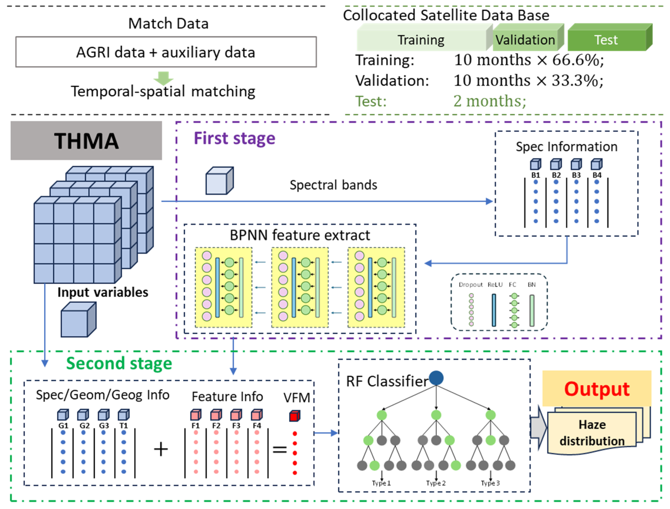
- Baseline A (RF-only). An RF classifier trained directly on the original variables. This baseline assesses the gain attributable solely to the BPNN’s feature extraction.
- Baseline B (BPNN-only). A standalone neural network, with the same architecture as the first stage, but capped with a task-specific output layer, was trained end-to-end for classification. This baseline isolates the performance of a purely machine learning approach.
- Proposed Model (BPNN + RF). The full two-stage THMA model, where the RF classifier is trained on the multi-dimensional features learned by the BPNN.
3. Results
3.1. Feature Screening
3.2. Model Accuracy Assessment
3.2.1. Ablation Experiment
3.2.2. Statistical Evaluation of the THMA Model
3.3. Application of THMA in Two Case Studies
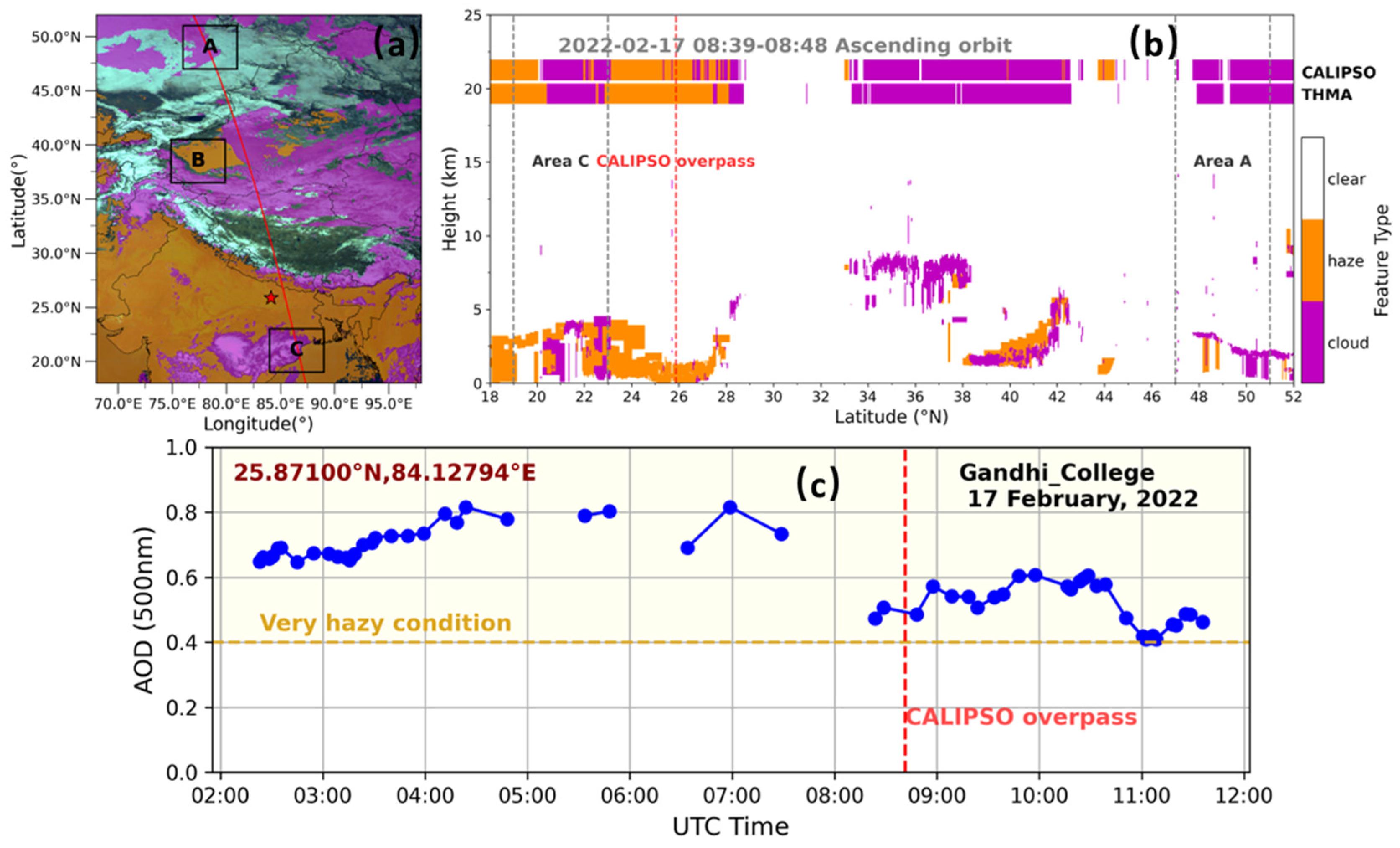
3.3.1. Case I
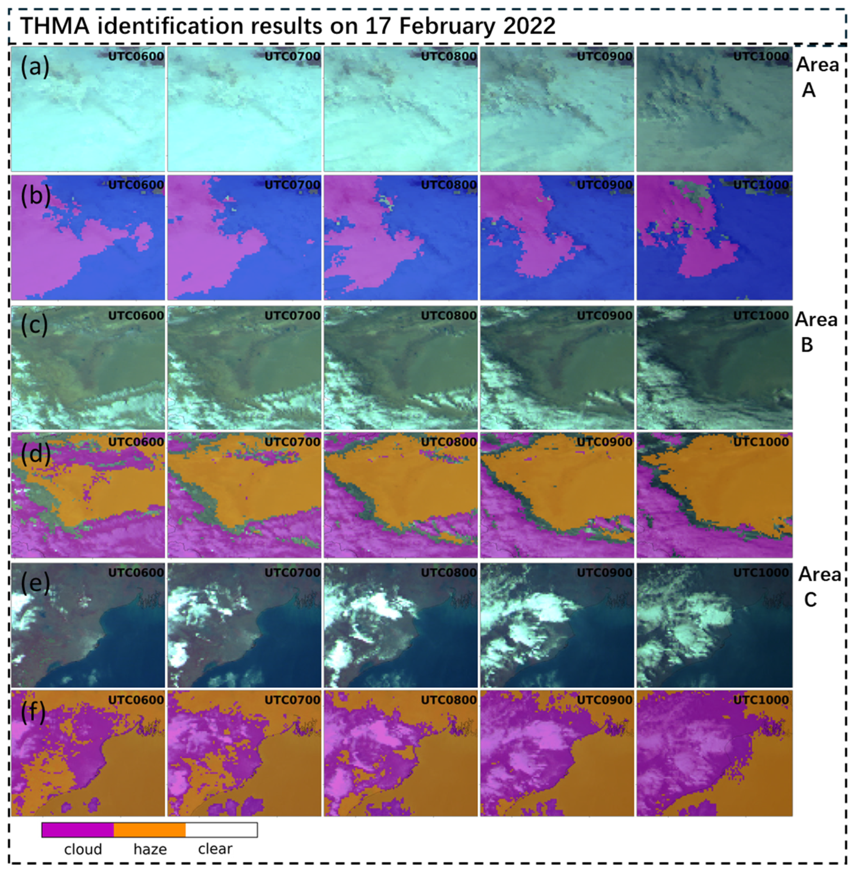
3.3.2. Case II
3.4. Diurnal Variation of Cloud and Haze
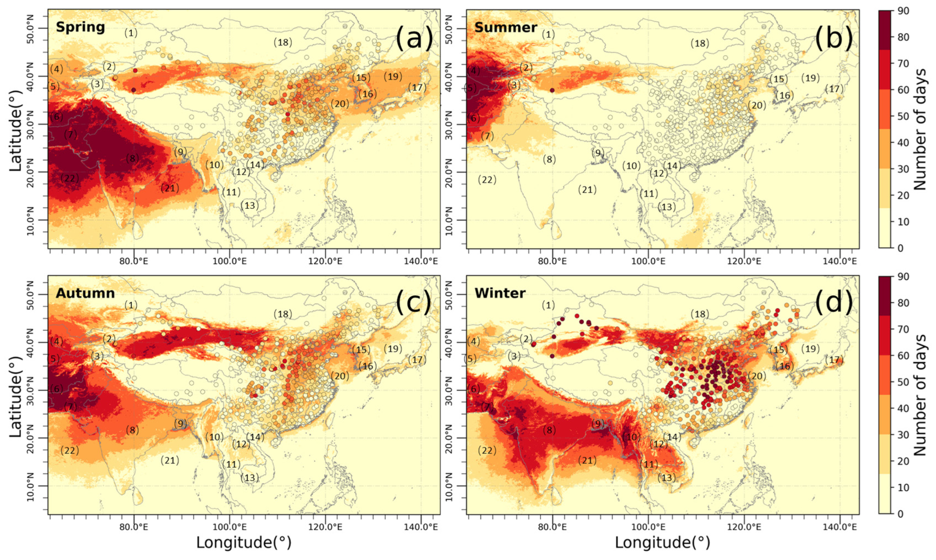
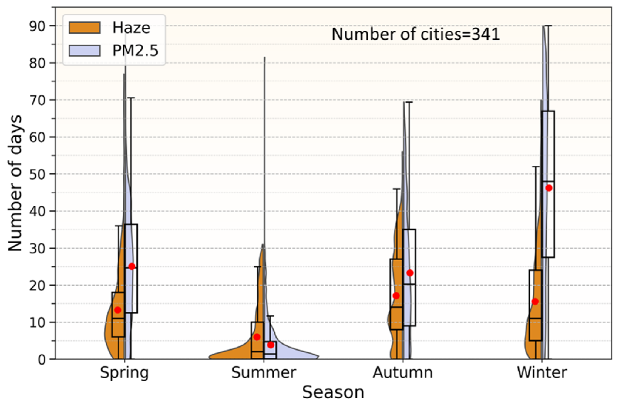
3.5. Number of Haze Days
4. Conclusions
Supplementary Materials
Author Contributions
Funding
Data Availability Statement
Acknowledgments
Conflicts of Interest
Abbreviations
| THMA | Two-stage haze mapping algorithm |
| MCR | Misclassification rate |
| FAR | False alarm rate |
| LR | Leakage rate |
| BPNN | Backpropagation neural network |
| RF | Random forest |
| AI | Artificial intelligence |
| AGRI | Advanced Geostationary Radiation Imager |
| CALIPSO | Cloud-Aerosol Lidar and Infrared Pathfinder Satellite Observations |
| CALIOP | Cloud and Aerosol Lidar with Orthogonal Polarization |
| VFM | Vertical feature mask |
| NSMC | National Satellite Meteorological Centre of China |
| NASA | National Aeronautics and Space Administration |
| AERONET | Aerosol Robotic Network |
| AOD | Aerosol optical depth |
| PM2.5 | Mass concentrations of fine particulate matter with diameters smaller than 2.5 μm |
| CNES | Centre National d’Études Spatiales |
| WMO | World Meteorological Organization |
| WHO | World Health Organization |
| CNEMC | China National Environmental Monitoring Center |
| NOAA | National Oceanic and Atmospheric Administration |
| DEM | Digital elevation model |
| ReLU | Rectified linear unit |
| ITHMA | Indicator of THMA |
| cld | Cloud |
| haz | Haze |
| cla | Clear air |
| NDVI | Normalized Difference Vegetation Index |
| NDSI | Normalized Difference Snow Index |
| NDDI | Normalized Difference Dust Index |
| NDVI-SWIR | Normalized Difference Vegetation Index-Shortwave Infrared |
| MODIS | Moderate resolution imaging spectroradiometer |
| XGBoost | Extreme gradient boosting |
| SVM | Support vector machines |
References
- World Meteorological Organization (WMO). Haze. In International Cloud Atlas; World Meteorological Organization: Geneva, Switzerland; Available online: https://cloudatlas.wmo.int/en/haze.html (accessed on 18 January 2026).
- Sun, Y.; Chen, C.; Zhang, Y.; Xu, W.; Zhou, L.; Cheng, X.; Zheng, H.; Ji, D.; Li, J.; Tang, X.; et al. Rapid Formation and Evolution of an Extreme Haze Episode in Northern China during Winter 2015. Sci. Rep. 2016, 6, 27151. [Google Scholar] [CrossRef] [Scilit]
- Neff, J.C.; Reynolds, R.L.; Munson, S.M.; Fernandez, D.; Belnap, J. The Role of Dust Storms in Total Atmospheric Particle Concentrations at Two Sites in the Western U.S. J. Geophys. Res. Atmos. 2013, 118, 11201–11212. [Google Scholar] [CrossRef] [Scilit]
- Vasilakopoulou, C.N.; Matrali, A.; Skyllakou, K.; Georgopoulou, M.; Aktypis, A.; Florou, K.; Kaltsonoudis, C.; Siouti, E.; Kostenidou, E.; Błaziak, A.; et al. Rapid Transformation of Wildfire Emissions to Harmful Background Aerosol. npj Clim. Atmos. Sci. 2023, 6, 218. [Google Scholar] [CrossRef] [Scilit]
- Bates, J.T.; Fang, T.; Verma, V.; Zeng, L.; Weber, R.J.; Tolbert, P.E.; Abrams, J.Y.; Sarnat, S.E.; Klein, M.; Mulholland, J.A.; et al. Review of Acellular Assays of Ambient Particulate Matter Oxidative Potential: Methods and Relationships with Composition, Sources, and Health Effects. Environ. Sci. Technol. 2019, 53, 4003–4019. [Google Scholar] [CrossRef] [Scilit] [PubMed]
- Johnston, F.H.; Henderson, S.B.; Chen, Y.; Randerson, J.T.; Marlier, M.; DeFries, R.S.; Kinney, P.; Bowman, D.M.J.S.; Brauer, M. Estimated Global Mortality Attributable to Smoke from Landscape Fires. Environ. Health Perspect. 2012, 120, 695–701. [Google Scholar] [CrossRef] [Scilit]
- Yu, W.; Xu, R.; Ye, T.; Abramson, M.J.; Morawska, L.; Jalaludin, B.; Johnston, F.H.; Henderson, S.B.; Knibbs, L.D.; Morgan, G.G.; et al. Estimates of Global Mortality Burden Associated with Short-Term Exposure to Fine Particulate Matter (PM2·5). Lancet Planet. Health 2024, 8, e146–e155. [Google Scholar] [CrossRef] [Scilit]
- Das, S.K.; Chatterjee, A.; Ghosh, S.K.; Raha, S. An Integrated Campaign for Investigation of Winter-Time Continental Haze over Indo-Gangetic Basin and Its Radiative Effects. Sci. Total Environ. 2015, 533, 370–382. [Google Scholar] [CrossRef] [Scilit]
- Ehn, M.; Thornton, J.A.; Kleist, E.; Sipilä, M.; Junninen, H.; Pullinen, I.; Springer, M.; Rubach, F.; Tillmann, R.; Lee, B.; et al. A Large Source of Low-Volatility Secondary Organic Aerosol. Nature 2014, 506, 476–479. [Google Scholar] [CrossRef] [Scilit]
- Bikkina, S.; Andersson, A.; Kirillova, E.N.; Holmstrand, H.; Tiwari, S.; Srivastava, A.K.; Bisht, D.S.; Gustafsson, Ö. Air Quality in Megacity Delhi Affected by Countryside Biomass Burning. Nat. Sustain. 2019, 2, 200–205. [Google Scholar] [CrossRef] [Scilit]
- Lu, S.; Gong, S.; He, J. Uncertainty Analysis of Spatiotemporal Characteristics of Haze Pollution from 1961 to 2017 in China. Atmos. Pollut. Res. 2020, 11, 310–318. [Google Scholar] [CrossRef] [Scilit]
- Shang, H.; Chen, L.; Letu, H.; Zhao, M.; Li, S.; Bao, S. Development of a Daytime Cloud and Haze Detection Algorithm for Himawari-8 Satellite Measurements over Central and Eastern China. J. Geophys. Res. Atmos. 2017, 122, 3528–3543. [Google Scholar] [CrossRef] [Scilit]
- Booth, B.B.B.; Dunstone, N.J.; Halloran, P.R.; Andrews, T.; Bellouin, N. Aerosols Implicated as a Prime Driver of Twentieth-Century North Atlantic Climate Variability. Nature 2012, 484, 228–232. [Google Scholar] [CrossRef] [Scilit]
- Kulmala, M.; Kontkanen, J.; Junninen, H.; Lehtipalo, K.; Manninen, H.E.; Nieminen, T.; Petäjä, T.; Sipilä, M.; Schobesberger, S.; Rantala, P.; et al. Direct Observations of Atmospheric Aerosol Nucleation. Science 2013, 339, 943–946. [Google Scholar] [CrossRef] [Scilit] [PubMed]
- Li, J.; Han, Z.; Wu, Y.; Xiong, Z.; Xia, X.; Li, J.; Liang, L.; Zhang, R. Aerosol Radiative Effects and Feedbacks on Boundary Layer Meteorology and PM2.5 Chemical Components during Winter Haze Events over the Beijing-Tianjin-Hebei Region. Atmos. Chem. Phys. 2020, 20, 8659–8690. [Google Scholar] [CrossRef] [Scilit]
- Zhan, J.; Chang, W.; Li, W.; Wang, Y.; Chen, L.; Yan, J. Impacts of Meteorological Conditions, Aerosol Radiative Feedbacks, and Emission Reduction Scenarios on the Coastal Haze Episodes in Southeastern China in December 2013. J. Appl. Meteorol. Climatol. 2017, 56, 1209–1229. [Google Scholar] [CrossRef] [Scilit]
- Huang, L.; Jiang, J.H.; Tackett, J.L.; Su, H.; Fu, R. Seasonal and Diurnal Variations of Aerosol Extinction Profile and Type Distribution from CALIPSO 5-year Observations. J. Geophys. Res. Atmos. 2013, 118, 4572–4596. [Google Scholar] [CrossRef] [Scilit]
- Robbins, D.; Poulsen, C.; Siems, S.; Proud, S. Improving Discrimination between Clouds and Optically Thick Aerosol Plumes in Geostationary Satellite Data. Atmos. Meas. Tech. 2022, 15, 3031–3051. [Google Scholar] [CrossRef] [Scilit]
- Shang, H.; Chen, L.; Tao, J.; Su, L.; Jia, S. Synergetic Use of MODIS Cloud Parameters for Distinguishing High Aerosol Loadings From Clouds Over the North China Plain. IEEE J. Sel. Top. Appl. Earth Obs. Remote Sens. 2014, 7, 4879–4886. [Google Scholar] [CrossRef] [Scilit]
- Tan, S.-C.; Zhang, X.; Wang, H.; Chen, B.; Shi, G.-Y.; Shi, C. Comparisons of Cloud Detection among Four Satellite Sensors on Severe Haze Days in Eastern China. Atmos. Ocean. Sci. Lett. 2018, 11, 86–93. [Google Scholar] [CrossRef] [Scilit]
- Zhang, X.; Wang, H.; Che, H.-Z.; Tan, S.-C.; Shi, G.-Y.; Yao, X.-P. The Impact of Aerosol on MODIS Cloud Detection and Property Retrieval in Seriously Polluted East China. Sci. Total Environ. 2020, 711, 134634. [Google Scholar] [CrossRef] [Scilit]
- Ackerman, S.; Strabala, K.; Menzel, P.; Frey, R.; Moeller, C.; Gumley, L.; Baum, B.; Seemann, S.W.; Zhang, H. Discriminating Clear-Sky from Cloud with MODIS: Algorithm Theoretical Basis Document (MOD35); MODIS Cloud Mask Team, NASA Goddard Space Flight Center: Greenbelt, MD, USA, 2006. Available online: https://modis-images.gsfc.nasa.gov/_docs/MOD35:MYD35_ATBD_C005.pdf (accessed on 21 January 2026).
- Martins, J.V.; Tanré, D.; Remer, L.; Kaufman, Y.; Mattoo, S.; Levy, R. MODIS Cloud Screening for Remote Sensing of Aerosols over Oceans Using Spatial Variability. Geophys. Res. Lett. 2002, 29, 1619. [Google Scholar] [CrossRef] [Scilit]
- Hutchison, K.D.; Iisager, B.D.; Kopp, T.J.; Jackson, J.M. Distinguishing Aerosols from Clouds in Global, Multispectral Satellite Data with Automated Cloud Classification Algorithms. J. Atmos. Ocean. Technol. 2008, 25, 501–518. [Google Scholar] [CrossRef] [Scilit]
- Si, Y.; Chen, L.; Zheng, Z.; Yang, L.; Wang, F.; Xu, N.; Zhang, X. A Novel Algorithm of Haze Identification Based on FY3D/MERSI-II Remote Sensing Data. Remote Sens. 2023, 15, 438. [Google Scholar] [CrossRef] [Scilit]
- Eck, T.F.; Holben, B.N.; Reid, J.S.; Dubovik, O.; Smirnov, A.; O’Neill, N.T.; Slutsker, I.; Kinney, P. Wavelength Dependence of the Optical Depth of Biomass Burning, Urban, and Desert Dust Aerosols. J. Geophys. Res. Atmos. 1999, 104, 31333–31349. [Google Scholar] [CrossRef] [Scilit]
- Shang, H.; Letu, H.; Peng, Z.; Wang, Z. Development of a Daytime Cloud and Aerosol Loadings Detection Algorithm for Himawari-8 Satellite Measurements over Desert. Int. Arch. Photogramm. Remote Sens. Spat. Inf. Sci. 2018, XLII-3/W5, 61–66. [Google Scholar] [CrossRef] [Scilit]
- Waquet, F.; Cornet, C.; Deuzé, J.-L.; Dubovik, O.; Ducos, F.; Goloub, P.; Herman, M.; Lapyonok, T.; Labonnote, L.C.; Riedi, J.; et al. Retrieval of Aerosol Microphysical and Optical Properties above Liquid Clouds from POLDER/PARASOL Polarization Measurements. Atmos. Meas. Tech. 2013, 6, 991–1016. [Google Scholar] [CrossRef] [Scilit]
- Sun, L.; Latifovic, R.; Pouliot, D. Haze Removal Based on a Fully Automated and Improved Haze Optimized Transformation for Landsat Imagery over Land. Remote Sens. 2017, 9, 972. [Google Scholar] [CrossRef] [Scilit]
- Wang, Y.; Chen, L.; Li, S.; Wang, X.; Yu, C.; Si, Y.; Zhang, Z. Interference of Heavy Aerosol Loading on the VIIRS Aerosol Optical Depth (AOD) Retrieval Algorithm. Remote Sens. 2017, 9, 397. [Google Scholar] [CrossRef] [Scilit]
- Vishwakarma, S.; Anuradha; Punj, D. A novel framework for satellite image dehazing using advanced computational techniques. In Proceedings of the 4th Asian Conference on Innovation in Technology (ASIANCON 2024), Pimpri Chinchwad, India, 23–25 August 2024; pp. 1–7. [Google Scholar] [CrossRef] [Scilit]
- Mei, L.; Vountas, M.; Gómez-Chova, L.; Rozanov, V.; Jäger, M.; Lotz, W.; Burrows, J.P.; Hollmann, R. A Cloud Masking Algorithm for the XBAER Aerosol Retrieval Using MERIS Data. Remote Sens. Environ. 2017, 197, 141–160. [Google Scholar] [CrossRef] [Scilit]
- Yan, X.; Shi, W.; Luo, N.; Zhao, W. A New Method of Satellite-Based Haze Aerosol Monitoring over the North China Plain and a Comparison with MODIS Collection 6 Aerosol Products. Atmos. Res. 2016, 171, 31–40. [Google Scholar] [CrossRef] [Scilit]
- Choi, W.; Lee, H.; Kim, D.; Kim, S. Improving Spatial Coverage of Satellite Aerosol Classification Using a Random Forest Model. Remote Sens. 2021, 13, 1268. [Google Scholar] [CrossRef] [Scilit]
- Choi, W.; Lee, H.; Park, J. A First Approach to Aerosol Classification Using Space-Borne Measurement Data: Machine Learning-Based Algorithm and Evaluation. Remote Sens. 2021, 13, 609. [Google Scholar] [CrossRef] [Scilit]
- Awais, M.; Wang, L. Machine Learning Based Aerosol Classification over South and East Asia Using MODIS Top of Atmosphere Reflectance and AERONET-Derived Clusters: A Remote Sensing Approach. Environ. Res. 2026, 288, 123315. [Google Scholar] [CrossRef] [Scilit] [PubMed]
- Rivas-Perea, P.; Rosiles, J.G.; Cota-Ruiz, J. Statistical and Neural Pattern Recognition Methods for Dust Aerosol Detection. Int. J. Remote Sens. 2013, 34, 7648–7670. [Google Scholar] [CrossRef] [Scilit]
- Marais, W.J.; Holz, R.E.; Reid, J.S.; Willett, R.M. Leveraging Spatial Textures, through Machine Learning, to Identify Aerosols and Distinct Cloud Types from Multispectral Observations. Atmos. Meas. Tech. 2020, 13, 5459–5480. [Google Scholar] [CrossRef] [Scilit]
- Lee, J.; Shi, Y.R.; Cai, C.; Ciren, P.; Wang, J.; Gangopadhyay, A.; Zhang, Z. Machine Learning Based Algorithms for Global Dust Aerosol Detection from Satellite Images: Inter-Comparisons and Evaluation. Remote Sens. 2021, 13, 456. [Google Scholar] [CrossRef] [Scilit]
- Mo, Y.; Yang, X.; Tang, H.; Li, Z. Smoke Detection from Himawari-8 Satellite Data over Kalimantan Island Using Multilayer Perceptrons. Remote Sens. 2021, 13, 3721. [Google Scholar] [CrossRef] [Scilit]
- Shi, L.; Zhang, J.; Zhang, D.; Igbawua, T.; Liu, Y. Developing a Dust Storm Detection Method Combining Support Vector Machine and Satellite Data in Typical Dust Regions of Asia. Adv. Space Res. 2020, 65, 1263–1278. [Google Scholar] [CrossRef] [Scilit]
- Segal-Rozenhaimer, M.; Li, A.; Das, K.; Chirayath, V. Cloud Detection Algorithm for Multi-Modal Satellite Imagery Using Convolutional Neural-Networks (CNN). Remote Sens. Environ. 2020, 237, 111446. [Google Scholar] [CrossRef] [Scilit]
- Shao, Z.; Pan, Y.; Diao, C.; Cai, J. Cloud Detection in Remote Sensing Images Based on Multiscale Features-Convolutional Neural Network. IEEE Trans. Geosci. Remote Sens. 2019, 57, 4062–4076. [Google Scholar] [CrossRef] [Scilit]
- Shelhamer, E.; Long, J.; Darrell, T. Fully Convolutional Networks for Semantic Segmentation. arXiv 2016, arXiv:1605.06211. [Google Scholar]
- Wei, J.; Huang, W.; Li, Z.; Sun, L.; Zhu, X.; Yuan, Q.; Liu, L.; Cribb, M. Cloud Detection for Landsat Imagery by Combining the Random Forest and Superpixels Extracted via Energy-Driven Sampling Segmentation Approaches. Remote Sens. Environ. 2020, 248, 112005. [Google Scholar] [CrossRef] [Scilit]
- Yang, Y.; Sun, W.; Chi, Y.; Yan, X.; Fan, H.; Yang, X.; Ma, Z.; Wang, Q.; Zhao, C. Machine Learning-Based Retrieval of Day and Night Cloud Macrophysical Parameters over East Asia Using Himawari-8 Data. Remote Sens. Environ. 2022, 273, 112971. [Google Scholar] [CrossRef] [Scilit]
- Chen, B.; Ye, Q.; Zhou, X.; Song, Z.; Ren, Y. Aerosol Classification under Non-Clear Sky Conditions Based on Geostationary Satellite FY-4A and Machine Learning Models. Atmos. Environ. 2024, 339, 120891. [Google Scholar] [CrossRef] [Scilit]
- Zhong, B.; Ma, Y.; Yang, A.; Wu, J. Radiometric Performance Evaluation of FY-4A/AGRI Based on Aqua/MODIS. Sensors 2021, 21, 1859. [Google Scholar] [CrossRef] [Scilit]
- He, X.; Li, H.; Zhou, G.; Tian, Z.; Wu, L. Cross-Radiometric Calibration and NDVI Application Comparison of FY-4A/AGRI Based on Aqua-MODIS. Remote Sens. 2023, 15, 5454. [Google Scholar] [CrossRef] [Scilit]
- Holben, B.N.; Eck, T.F.; Slutsker, I.; Tanré, D.; Buis, J.P.; Setzer, A.; Vermote, E.; Reagan, J.A.; Kaufman, Y.J.; Nakajima, T.; et al. AERONET—A Federated Instrument Network and Data Archive for Aerosol Characterization. Remote Sens. Environ. 1998, 66, 1–16. [Google Scholar] [CrossRef] [Scilit]
- Aybar, C.; Ysuhuaylas, L.; Loja, J.; Gonzales, K.; Herrera, F.; Bautista, L.; Yali, R.; Flores, A.; Diaz, L.; Cuenca, N.; et al. CloudSEN12, a Global Dataset for Semantic Understanding of Cloud and Cloud Shadow in Sentinel-2. Sci. Data 2022, 9, 782. [Google Scholar] [CrossRef] [Scilit]
- Romero, A.; Gatta, C.; Camps-Valls, G. Unsupervised Deep Feature Extraction for Remote Sensing Image Classification. IEEE Trans. Geosci. Remote Sens. 2016, 54, 1349–1362. [Google Scholar] [CrossRef] [Scilit]
- Zhang, J. Multi-Source Remote Sensing Data Fusion: Status and Trends. Int. J. Image Data Fusion 2010, 1, 5–24. [Google Scholar] [CrossRef] [Scilit]
- Taylor, S.; Stier, P.; White, B.; Finkensieper, S.; Stengel, M. Evaluating the Diurnal Cycle in Cloud Top Temperature from SEVIRI. Atmos. Chem. Phys. 2017, 17, 7035–7053. [Google Scholar] [CrossRef] [Scilit]
- Kim, M.; Omar, A.H.; Vaughan, M.A.; Winker, D.M.; Trepte, C.R.; Hu, Y.; Liu, Z.; Kim, S. Quantifying the Low Bias of CALIPSO’s Column Aerosol Optical Depth Due to Undetected Aerosol Layers. J. Geophys. Res. Atmos. 2017, 122, 1098–1113. [Google Scholar] [CrossRef] [Scilit] [PubMed]
- Liu, Z.; Winker, D.; Omar, A.; Vaughan, M.; Kar, J.; Trepte, C.; Hu, Y.; Schuster, G. Evaluation of CALIOP 532 Nm Aerosol Optical Depth over Opaque Water Clouds. Atmos. Chem. Phys. 2015, 15, 1265–1288. [Google Scholar] [CrossRef] [Scilit]
- Omar, A.H.; Winker, D.M.; Tackett, J.L.; Giles, D.M.; Kar, J.; Liu, Z.; Vaughan, M.A.; Powell, K.A.; Trepte, C.R. CALIOP and AERONET Aerosol Optical Depth Comparisons: One Size Fits None. J. Geophys. Res. Atmos. 2013, 118, 4748–4766. [Google Scholar] [CrossRef] [Scilit]
- Jiang, H.; He, Q.; Li, R.; Tang, H.; Zhao, Q.; Zhang, H.; Li, J.; Li, Y.; Li, J. Analysis of the Horizontal and Vertical Distribution of a Dust Weather Event in the Tarim Basin Based on Multi-Source Observational Datasets. Atmos. Pollut. Res. 2025, 16, 102455. [Google Scholar] [CrossRef] [Scilit]
- Li, Z.; Gu, X.; Wang, L.; Li, D.; Xie, Y.; Li, K.; Dubovik, O.; Schuster, G.; Goloub, P.; Zhang, Y.; et al. Aerosol Physical and Chemical Properties Retrieved from Ground-Based Remote Sensing Measurements during Heavy Haze Days in Beijing Winter. Atmos. Chem. Phys. 2013, 13, 10171–10183. [Google Scholar] [CrossRef] [Scilit]
- Zhang, M.; Ma, Y.; Gong, W.; Zhu, Z. Aerosol Optical Properties of a Haze Episode in Wuhan Based on Ground-Based and Satellite Observations. Atmosphere 2014, 5, 699–719. [Google Scholar] [CrossRef] [Scilit]
- Banerjee, T.; Shitole, A.S.; Mhawish, A.; Anand, A.; Ranjan, R.; Khan, M.F.; Srithawirat, T.; Latif, M.T.; Mall, R.K. Aerosol Climatology Over South and Southeast Asia: Aerosol Types, Vertical Profile, and Source Fields. J. Geophys. Res. Atmos. 2021, 126, e2020JD033554. [Google Scholar] [CrossRef] [Scilit]
- Strahler, A.; Muchoney, D.; Borak, J.; Friedl, M.; Gopal, S.; Lambin, E.; Moody, A. MODIS Land Cover Product Algorithm Theoretical Basis Document (ATBD): Version 5.0; Alan Strahler Center for Remote Sensing, Department of Geography, Boston University: Boston, MA, USA, 1999. Available online: https://modis.gsfc.nasa.gov/data/atbd/atbd_mod12.pdf (accessed on 21 January 2026).
- Yan, X.; Zang, Z.; Li, Z.; Chen, H.W.; Chen, J.; Jiang, Y.; Chen, Y.; He, B.; Zuo, C.; Nakajima, T.; et al. Deep Learning with Pretrained Framework Unleashes the Power of Satellite-Based Global Fine-Mode Aerosol Retrieval. Environ. Sci. Technol. 2024, 58, 14260–14270. [Google Scholar] [CrossRef] [Scilit] [PubMed]
- Hutchison, K.D.; Iisager, B.D.; Hauss, B. The Use of Global Synthetic Data for Pre-Launch Tuning of the VIIRS Cloud Mask Algorithm. Int. J. Remote Sens. 2012, 33, 1400–1423. [Google Scholar] [CrossRef] [Scilit]
- Kopp, T.J.; Thomas, W.; Heidinger, A.K.; Botambekov, D.; Frey, R.A.; Hutchison, K.D.; Iisager, B.D.; Brueske, K.; Reed, B. The VIIRS Cloud Mask: Progress in the First Year of S-NPP toward a Common Cloud Detection Scheme. J. Geophys. Res. Atmos. 2014, 119, 2441–2456. [Google Scholar] [CrossRef] [Scilit]
- Bennett, K.E.; Miller, G.; Busey, R.; Chen, M.; Lathrop, E.R.; Dann, J.B.; Nutt, M.; Crumley, R.; Dillard, S.L.; Dafflon, B.; et al. Spatial Patterns of Snow Distribution in the Sub-Arctic. Cryosphere 2022, 16, 3269–3293. [Google Scholar] [CrossRef] [Scilit]
- Hsu, N.C.; Tsay, S.C.; King, M.D.; Herman, J.R. Aerosol Properties over Bright-Reflecting Source Regions. IEEE Trans. Geosci. Remote Sens. 2004, 42, 557–569. [Google Scholar] [CrossRef] [Scilit]
- Ackerman, S.A.; Strabala, K.I.; Menzel, W.P.; Frey, R.A.; Moeller, C.C.; Gumley, L.E. Discriminating Clear Sky from Clouds with MODIS. J. Geophys. Res. Atmos. 1998, 103, 32141–32157. [Google Scholar] [CrossRef] [Scilit]
- Saunders, R.W.; Kriebel, K.T. An Improved Method for Detecting Clear Sky and Cloudy Radiances from AVHRR Data. Int. J. Remote Sens. 1988, 9, 123–150. [Google Scholar] [CrossRef] [Scilit]
- Zhang, X.; Zhao, S.-Y.; Tang, R.-X. Improved Daytime Cloud Detection Algorithm in FY-4A’s Advanced Geostationary Radiation Imager. Atmosphere 2025, 16, 1105. [Google Scholar] [CrossRef] [Scilit]
- Marchand, R.; Ackerman, T.; Smyth, M.; Rossow, W.B. A Review of Cloud Top Height and Optical Depth Histograms from MISR, ISCCP, and MODIS. J. Geophys. Res. Atmos. 2010, 115, 2009JD013422. [Google Scholar] [CrossRef] [Scilit]
- Baum, B.A.; Yang, P.; Heymsfield, A.J.; Bansemer, A.; Cole, B.H.; Merrelli, A.; Schmitt, C.; Wang, C. Ice Cloud Single-Scattering Property Models with the Full Phase Matrix at Wavelengths from 0.2 to 100 µm. J. Quant. Spectrosc. Radiat. Transf. 2014, 146, 123–139. [Google Scholar] [CrossRef] [Scilit]
- Macke, A.; Francis, P.N.; McFarquhar, G.M.; Kinne, S. The Role of Ice Particle Shapes and Size Distributions in the Single Scattering Properties of Cirrus Clouds. J. Atmos. Sci. 1998, 55, 2874–2883. [Google Scholar] [CrossRef] [Scilit]
- Jiang, H.; He, Q.; Zhang, J.; Tang, Y.; Chen, C.; Lv, X.; Zhang, Y.; Liu, Z. Dust Storm Detection of a Convolutional Neural Network and a Physical Algorithm Based on FY-4A Satellite Data. Adv. Space Res. 2022, 69, 4288–4306. [Google Scholar] [CrossRef] [Scilit]
- Zhang, Z.; Huang, J.; Chen, B.; Yi, Y.; Liu, J.; Bi, J.; Zhou, T.; Huang, Z.; Chen, S. Three-Year Continuous Observation of Pure and Polluted Dust Aerosols Over Northwest China Using the Ground-Based Lidar and Sun Photometer Data. J. Geophys. Res. Atmos. 2019, 124, 1118–1131. [Google Scholar] [CrossRef] [Scilit]
- Ali, M.A.; Bilal, M.; Wang, Y.; Qiu, Z.; Nichol, J.E.; Mhawish, A.; De Leeuw, G.; Zhang, Y.; Shahid, S.; Almazroui, M.; et al. Spatiotemporal Changes in Aerosols over Bangladesh Using 18 Years of MODIS and Reanalysis Data. J. Environ. Manag. 2022, 315, 115097. [Google Scholar] [CrossRef] [Scilit] [PubMed]
- Ali, M.A.; Assiri, M.E.; Bilal, M.; Tariq, S.; de Leeuw, G.; Islam, M.N.; Wang, Y.; Alamri, L.; Ghulam, A.S.; Shahid, S. Long-Term PM2.5 Exposure in Bangladesh: Identification of Pollution Hotspots, Trends, Sources and Health Risk Assessment. Air Qual. Atmos. Health 2025, 18, 2229–2246. [Google Scholar] [CrossRef] [Scilit]
- Bilal, M.; Mhawish, A.; Nichol, J.E.; Qiu, Z.; Nazeer, M.; Ali, M.A.; De Leeuw, G.; Levy, R.C.; Wang, Y.; Chen, Y.; et al. Air Pollution Scenario over Pakistan: Characterization and Ranking of Extremely Polluted Cities Using Long-Term Concentrations of Aerosols and Trace Gases. Remote Sens. Environ. 2021, 264, 112617. [Google Scholar] [CrossRef] [Scilit]
- Khan, R.; Kumar, K.R.; Zhao, T.; Ullah, W.; De Leeuw, G. Interdecadal Changes in Aerosol Optical Depth over Pakistan Based on the MERRA-2 Reanalysis Data during 1980–2018. Remote Sens. 2021, 13, 822. [Google Scholar] [CrossRef] [Scilit]



| Band | Center Wavelength | Bandwidth | Resolution |
|---|---|---|---|
| 1 | 0.47 µm | 0.45~0.49 µm | 1 km |
| 2 | 0.65 µm | 0.55~0.75 µm | 0.5~1 km |
| 3 | 0.825 µm | 0.75~0.90 µm | 1 km |
| 4 | 1.375 µm | 1.36~1.39 µm | 2 km |
| 5 | 1.61 µm | 1.58~1.64 µm | 2 km |
| 6 | 2.25 µm | 2.1~2.35 µm | 2~4 km |
| 7 | 3.75 µm | 3.5~4.0 µm | 2 km |
| 8 | 3.75 µm | 3.5~4.0 µm | 4 km |
| 9 | 6.25 µm | 5.8~6.7 µm | 4 km |
| 10 | 7.1 µm | 6.9~7.3 µm | 4 km |
| 11 | 8.5 µm | 8.0~9.0 µm | 4 km |
| 12 | 10.7 µm | 10.3~11.3 µm | 4 km |
| 13 | 12.0 µm | 11.5~12.5 µm | 4 km |
| 14 | 13.5 µm | 13.2~13.8 µm | 4 km |
| Variables in the First Stage | Variables in the Second Stage | |
|---|---|---|
| Spectral information | CH1(0.47 µm), CH2(0.65 µm), CH3(0.825 µm), CH4(1.375 µm), CH5(1.61 µm), CH6(2.25 µm), CH8(3.75 µm), CH9(6.25 µm), CH10(7.1 µm), CH11(8.5 µm), CH12(10.7 µm), CH13(12.0 µm), CH14(13.5 µm) | |
| Combined metrics | CH3/CH2, CH3/CH5, CH10-CH12, CH12-CH8, CH12-CH13, NDVI, NDSI, NDVI-SWIR | CH3/CH5, CH10-CH12, CH12-CH8, NDVI, NDSI |
| Geometric and geographic information | / | SZA, Elevation, Latitude, Longitude |
| Extracted features | / | N1, N5, N6, N7, N8, N10, N11, N12, N14 1 |
| Validation Data Set | Test Data Set | |||||||||||||||
|---|---|---|---|---|---|---|---|---|---|---|---|---|---|---|---|---|
| Model | Month | 1 | 3 | 4 | 5 | 6 | 7 | 9 | 11 | 12 | Ave | Total | 2 | 8 | Ave | Total |
| (%) | 1.87 | 2.15 | 2.54 | 3.58 | 3.06 | 2.15 | 1.72 | 1.53 | 1.32 | 2.24 | 7.88 | 2.16 | 2.45 | 2.28 | 13.16 | |
| THMA | (%) | 3.02 | 2.30 | 3.07 | 3.63 | 2.90 | 2.59 | 3.71 | 2.49 | 2.94 | 2.96 | 4.41 | 7.98 | 5.83 | ||
| (%) | 1.97 | 2.06 | 2.56 | 3.40 | 2.91 | 3.06 | 3.07 | 3.38 | 1.40 | 2.68 | 5.38 | 4.56 | 5.06 | |||
| (%) | 1.78 | 2.62 | 3.08 | 3.99 | 3.77 | 2.85 | 1.82 | 1.53 | 0.99 | 2.55 | 9.97 | 3.26 | 2.57 | 2.99 | 16.11 | |
| RF | (%) | 3.70 | 2.68 | 4.28 | 4.63 | 4.20 | 5.02 | 5.82 | 3.61 | 3.37 | 4.18 | 4.10 | 12.09 | 7.27 | ||
| (%) | 3.30 | 2.91 | 3.13 | 3.80 | 3.67 | 2.86 | 3.30 | 3.79 | 2.07 | 3.23 | 6.89 | 4.29 | 5.86 | |||
| (%) | 1.47 | 1.21 | 1.27 | 2.17 | 2.20 | 2.27 | 2.33 | 1.72 | 1.72 | 1.79 | 12.96 | 1.07 | 2.34 | 1.57 | 14.64 | |
| BPNN | (%) | 5.30 | 5.63 | 8.78 | 7.70 | 6.06 | 5.45 | 6.42 | 6.95 | 3.59 | 6.39 | 6.80 | 5.04 | 6.10 | ||
| (%) | 4.36 | 3.61 | 4.79 | 5.80 | 5.58 | 4.65 | 6.46 | 3.61 | 3.59 | 4.76 | 5.01 | 9.96 | 6.97 | |||
| Sample Num | 9053 | 9271 | 11,082 | 7972 | 7184 | 8805 | 9082 | 7831 | 5067 | / | 75,347 | 32,319 | 21,236 | / | 53,555 | |
| Metrics over Validation Data Set | Metrics over Test Data Set | |||||||
|---|---|---|---|---|---|---|---|---|
| Precision % | Recall % | F1 Score | Num 1 | Precision % | Recall % | F1 Score | Num 1 | |
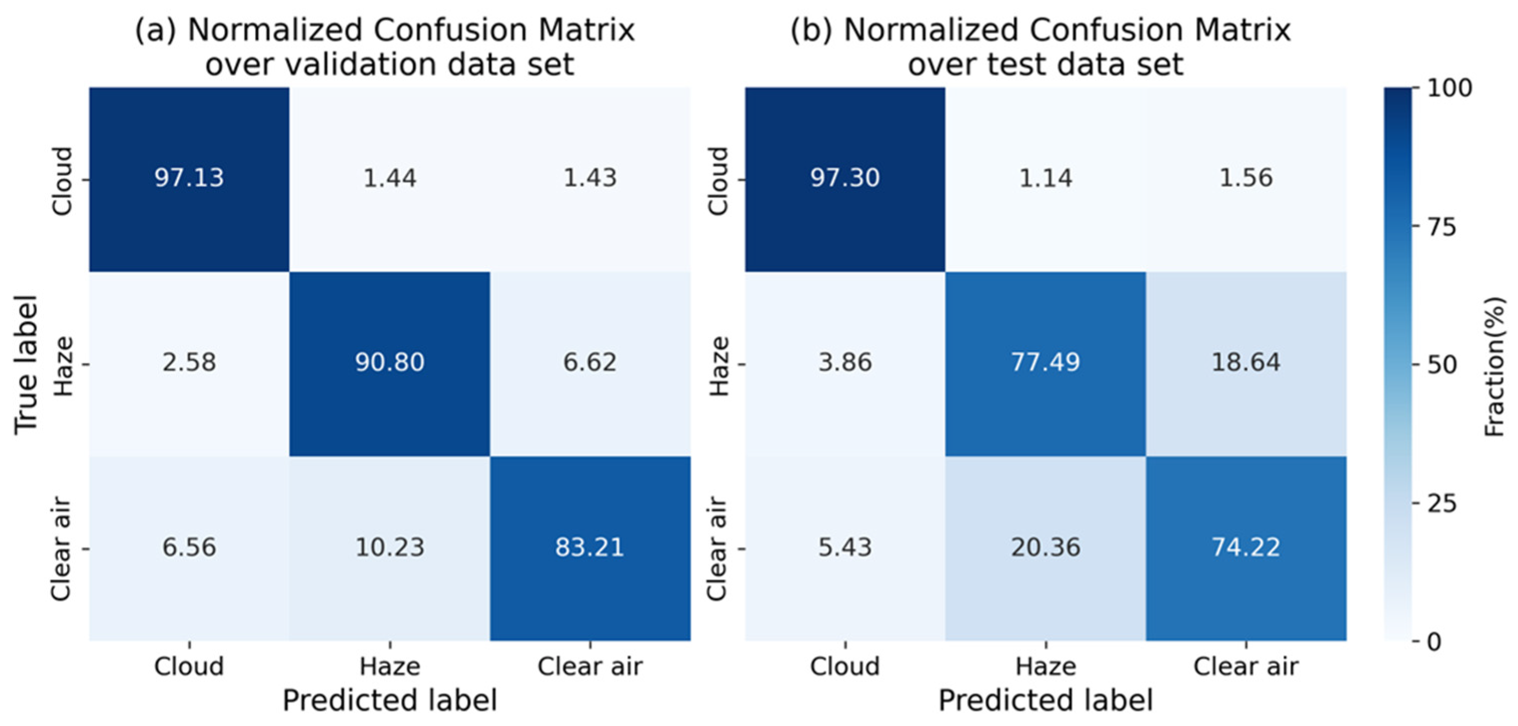
| Cloud | 95.38 | 97.13 | 0.96 | 35,852 | 95.65 | 97.30 | 0.96 | 27,556 |
| Haze | 90.24 | 90.80 | 0.91 | 22,724 | 75.21 | 77.49 | 0.76 | 12,215 |
| Clear air | 87.37 | 83.21 | 0.85 | 16,771 | 79.07 | 74.22 | 0.77 | 13,784 |
Disclaimer/Publisher’s Note: The statements, opinions and data contained in all publications are solely those of the individual author(s) and contributor(s) and not of MDPI and/or the editor(s). MDPI and/or the editor(s) disclaim responsibility for any injury to people or property resulting from any ideas, methods, instructions or products referred to in the content. |
© 2026 by the authors. Licensee MDPI, Basel, Switzerland. This article is an open access article distributed under the terms and conditions of the Creative Commons Attribution (CC BY) license.
Share and Cite
Liu, O.; Zhang, Y.; de Leeuw, G.; Yan, C.; Qie, L.; Chen, Y.; Fan, C.; Li, Z. A Two-Stage Algorithm for Pan-Asian Haze Mapping with the FY-4A/AGRI Geostationary Imager. Remote Sens. 2026, 18, 737. https://doi.org/10.3390/rs18050737
Liu O, Zhang Y, de Leeuw G, Yan C, Qie L, Chen Y, Fan C, Li Z. A Two-Stage Algorithm for Pan-Asian Haze Mapping with the FY-4A/AGRI Geostationary Imager. Remote Sensing. 2026; 18(5):737. https://doi.org/10.3390/rs18050737
Chicago/Turabian StyleLiu, Ouyang, Ying Zhang, Gerrit de Leeuw, Chaoyu Yan, Lili Qie, Yu Chen, Cheng Fan, and Zhengqiang Li. 2026. "A Two-Stage Algorithm for Pan-Asian Haze Mapping with the FY-4A/AGRI Geostationary Imager" Remote Sensing 18, no. 5: 737. https://doi.org/10.3390/rs18050737
APA StyleLiu, O., Zhang, Y., de Leeuw, G., Yan, C., Qie, L., Chen, Y., Fan, C., & Li, Z. (2026). A Two-Stage Algorithm for Pan-Asian Haze Mapping with the FY-4A/AGRI Geostationary Imager. Remote Sensing, 18(5), 737. https://doi.org/10.3390/rs18050737