Spatiotemporal Prediction of Wind Fields in Coastal Urban Environments Using Multi-Source Satellite Data: A GeoAI Approach

 , ,
, ,
Highlights
- A novel lightweight GeoAI framework (DA-DSC-UNet) is proposed to fuse multi-source satellite data (ASCAT, FY-3E, QuickSCAT) for high-resolution coastal wind field prediction.
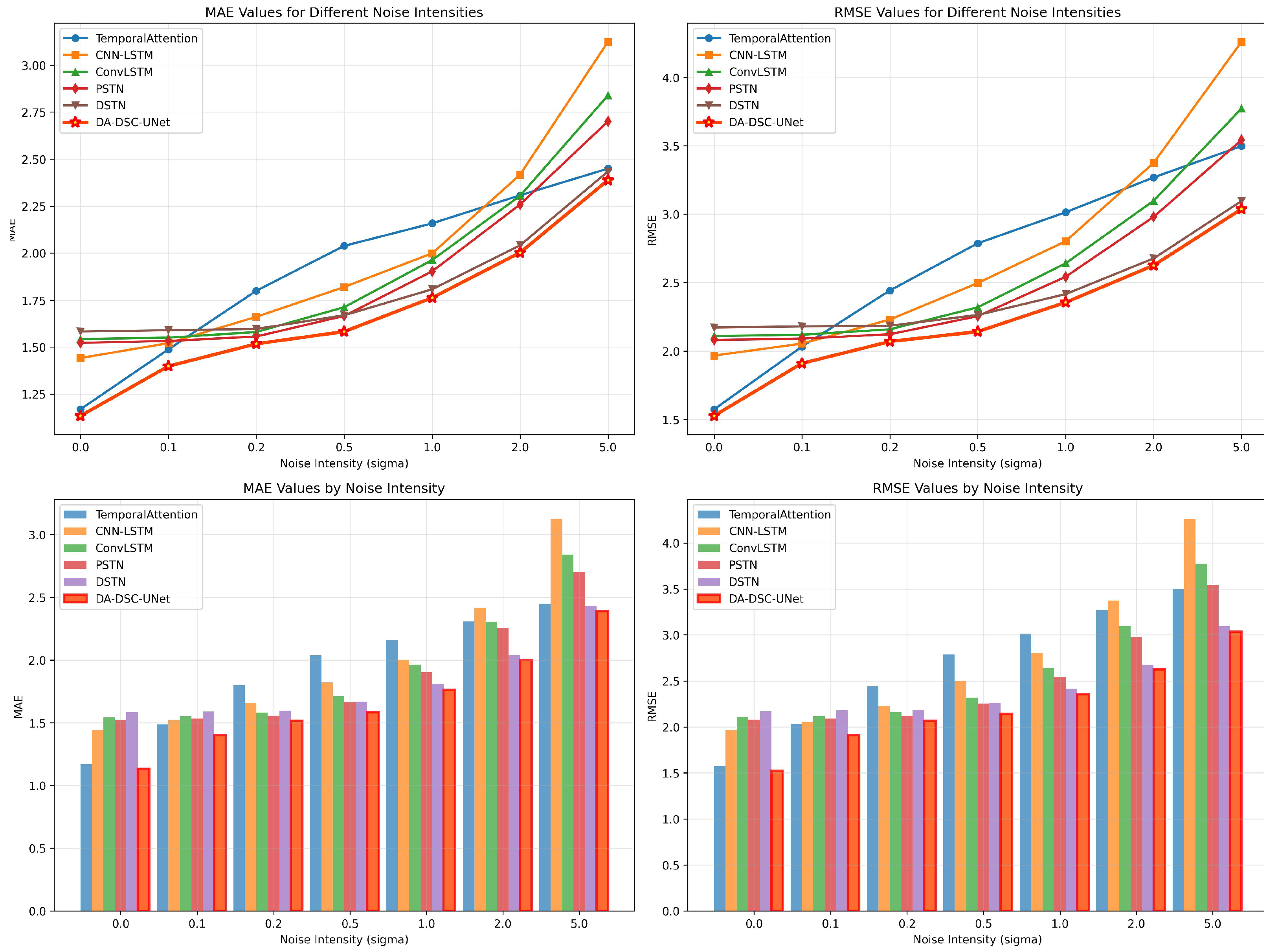
- The model significantly outperforms existing methods by reducing the Mean Absolute Error (MAE) by 14–25.8% and demonstrates exceptional robustness against observational noise.
- The accurate wind field reconstruction provides critical decision support for urban disaster mitigation, pollutant dispersion monitoring, and infrastructure resilience in complex coastal zones.
- Due to its low computational cost, the framework enables real-time deployment on edge devices, directly contributing to the monitoring of Sustainable Development Goal 11 (Sustainable Cities).
Abstract
1. Introduction
2. Materials and Methods
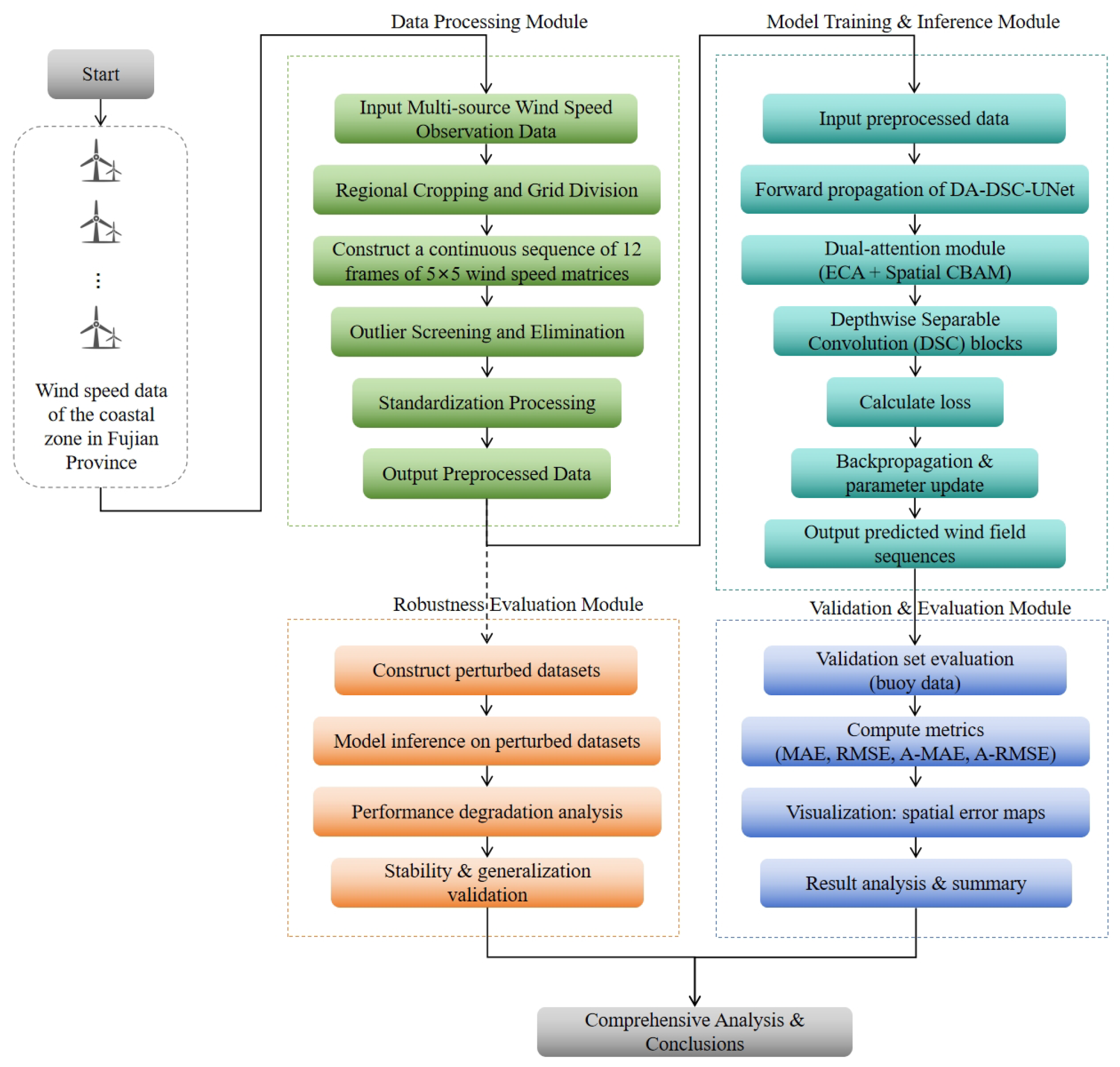
- Multi-source Data Fusion: Integrating large-scale satellite-derived wind field inversions with precise in situ buoy observations to construct a comprehensive spatiotemporal dataset covering the coastal urban agglomeration.
- GeoAI-driven Spatiotemporal Modeling: Deploying the DA-DSC-UNet, which incorporates dual-attention mechanisms and depthwise separable convolutions (DSC), to efficiently learn the nonlinear evolution of wind fields over complex terrain.
- Accuracy Assessment: Rigorous validation using independent in situ data to quantify the model’s performance in capturing local climate dynamics.
- Robustness Analysis: Evaluating the model’s stability under observational noise to ensure its reliability for practical urban environmental monitoring and disaster early warning.

2.1. Study Area and Data
- Spatiotemporal Alignment: The raw observational data were spatially cropped to the study area and re-gridded with a step size of 0.125°, mapping all multi-source observations onto a regular grid. Although this spatial resolution (approximately 14 km) is relatively coarse for resolving micro-scale urban features such as street canyons, it is highly appropriate for monitoring the mesoscale background wind field covering the entire coastal urban agglomeration. This scale effectively captures regional atmospheric transport patterns and synoptic weather systems (e.g., typhoons) that drive local urban ventilation, serving as a critical boundary condition for finer-scale urban climate models.
- Quality Control: We applied threshold-based filtering to remove physical outliers. Wind speed values outside the range of 0.2 m/s to 30 m/s were discarded. Furthermore, to ensure data integrity, any local sample patch ( grid) containing more than 12% missing values (i.e., more than 3 invalid points) was excluded.
- Sequence Construction: The valid data were organized into spatiotemporal sequences. We used a sliding window approach to construct input samples, where each sample consists of a sequence of 12 historical frames to predict the wind speed values for the next 12 time steps. To strictly prevent data leakage, the sliding window operates with a temporal stride of 1 time step exclusively within the respective training or validation periods. The dataset partitioning is based on a strict temporal split (Training: 2021; Validation: 2022), ensuring that there is no temporal overlap between the samples used for optimization and those used for evaluation. This design forces the model to learn the transferable spatiotemporal evolution rules rather than memorizing static spatial patterns. The final dataset covers the period from 1 January 2021 to February 2022.
2.2. GeoAI Model Architecture: DA-DSC-UNet
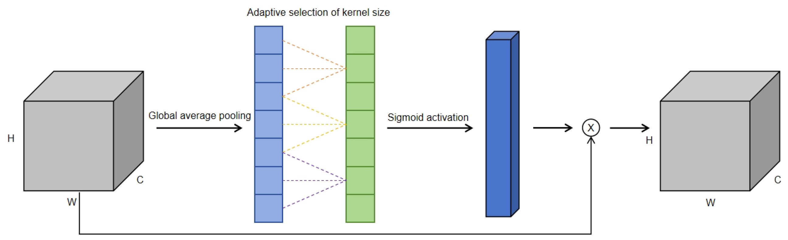
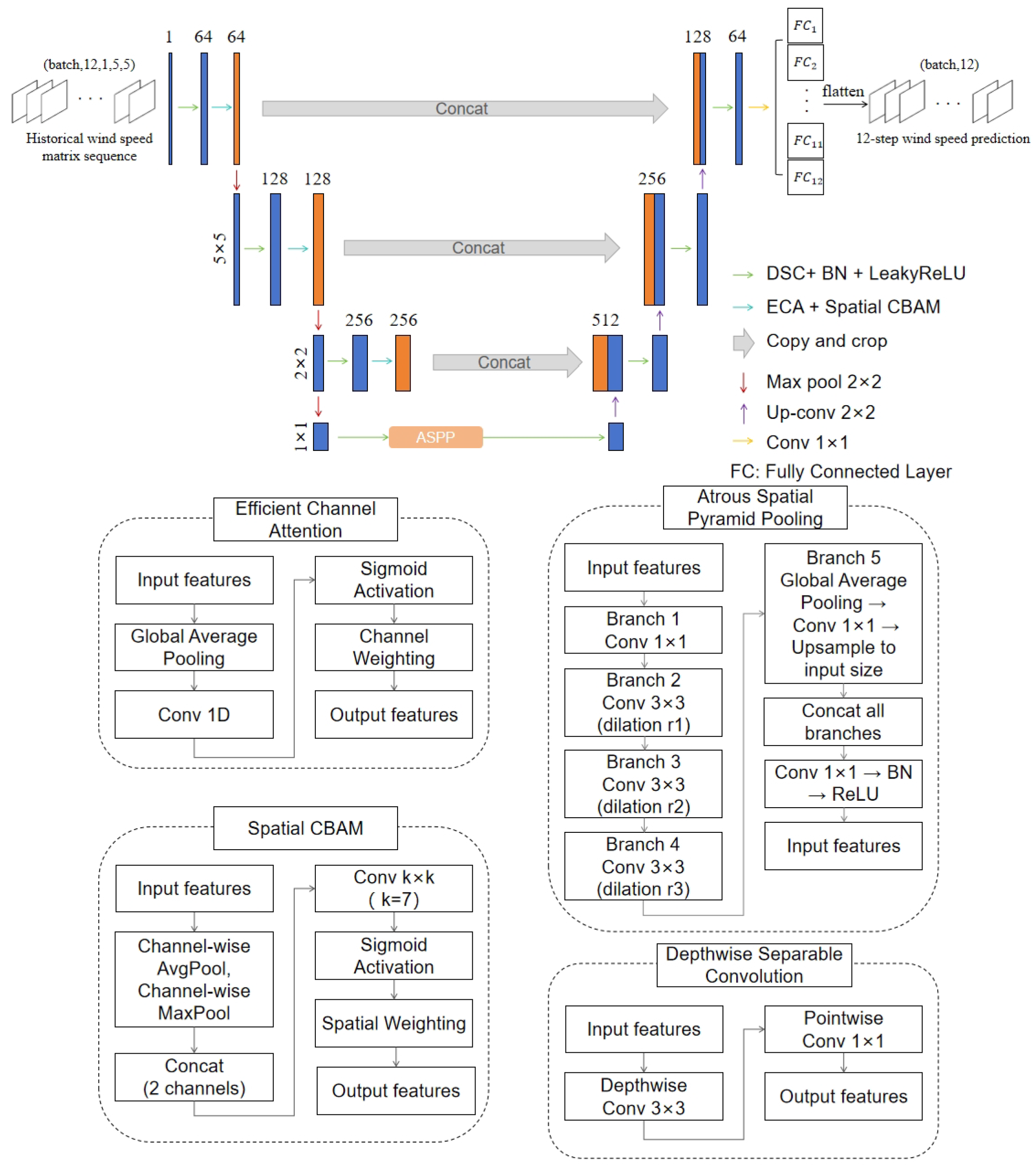
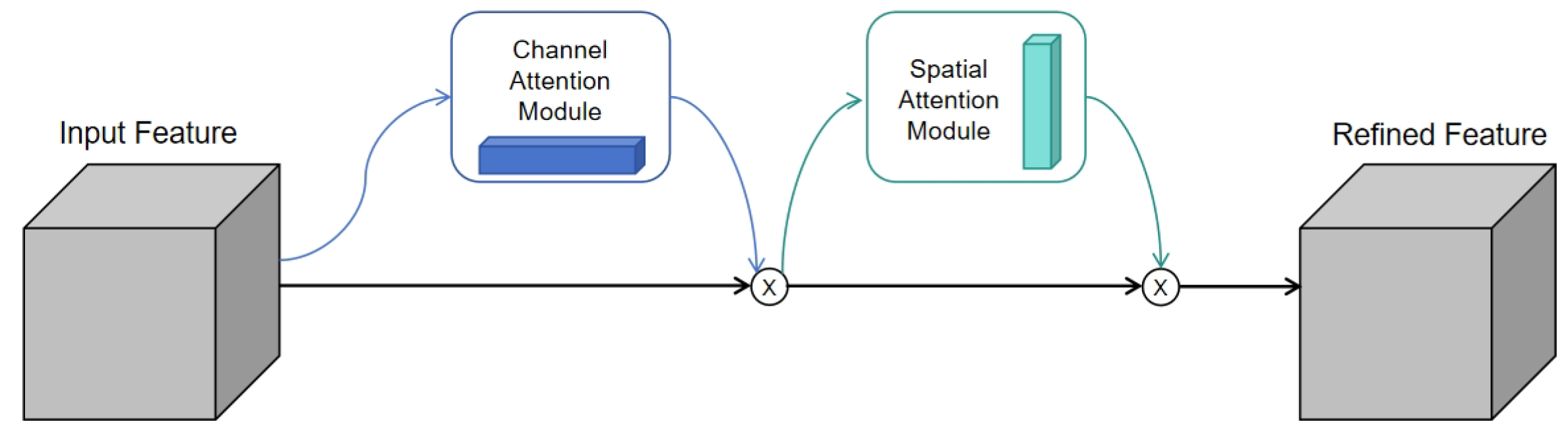
- Dual-Attention Mechanism: Embedded within the convolutional blocks to adaptively highlight geographically salient regions (e.g., coastlines, islands) and critical feature channels.
- Depthwise Separable Convolution: Replaces standard convolutions to minimize computational redundancy, facilitating efficient deployment in resource-constrained monitoring systems.
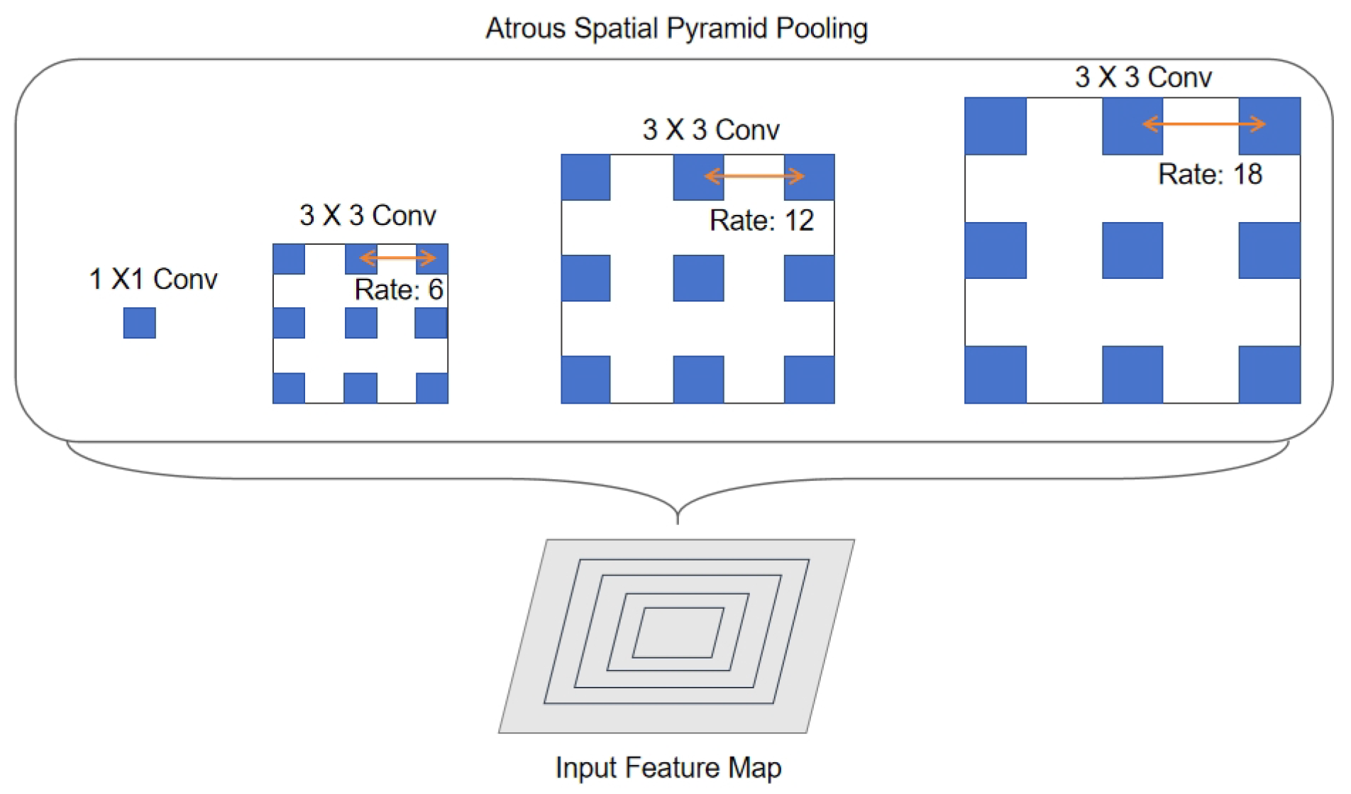
- Atrous Spatial Pyramid Pooling: Integrated at the bottleneck layer to capture multi-scale atmospheric contextual information, ranging from local urban roughness to regional circulation patterns.
2.2.1. Dual-Attention Module for Spatiotemporal Feature Refinement
2.2.2. DSC for Efficient Computation
2.2.3. ASPP for Multi-Scale Context Aggregation
2.2.4. Overall Architecture of DA-DSC-UNet
2.3. Experimental Setup
- Data Consistency: The multi-source satellite products (particularly FY-3E) provided the most stable and continuous high-quality observations during this period.
- Seasonal Representation: The training set covers a full annual cycle, enabling the model to learn seasonal wind patterns, while the validation set (Jan–Feb) represents the winter monsoon season, which is characterized by high wind speeds and volatility, serving as a rigorous test for model robustness.
2.4. Evaluation Metrics
3. Results
3.1. Overall Performance Comparison
3.2. Result Error Analysis
3.3. Spatiotemporal Error Distribution
3.4. Noise Robustness Evaluation
3.5. Ablation Experiment
- Impact of Attention Mechanisms: Both ECA and CBAM modules yield clear performance gains over the baseline. The ECA module reduces MAE by approximately 3.4%, while the dual-attention combination (ECA+CBAM-UNet) further suppresses the MAE to 1.2835 m/s. While attention mechanisms introduce a slight overhead in inference time (increasing from 14.24 ms to 15.42 ms), the cost is negligible compared to the accuracy gains.
- Efficiency of DSC: The DSC-UNet demonstrates a dramatic reduction in computational cost. By replacing standard convolutions, the parameter count drops by ∼64% (from 656 k to 233 k), and FLOPs decrease by ∼77% (from 57.97 M to 13.26 M), while maintaining accuracy comparable to the baseline. Crucially, the inference speed accelerates by nearly 2.5 times (5.82 ms vs. 14.24 ms), and memory usage drops to just 320 MB. This highlights the potential of DSC for lightweight deployment in resource-constrained urban monitoring devices.
- Importance of Multi-scale Context: The ASPP module (ASPP-UNet) significantly improves prediction accuracy (MAE drops to 1.2433 m/s) by capturing long-range dependencies. However, this comes at the cost of nearly doubling the parameter size and increasing computational load, with inference time rising to 22.56 ms.
- Synergy in the Proposed Model: The final DA-DSC-UNet achieves the optimal balance. By integrating the lightweight characteristics of DSC with the powerful feature extraction of dual attention and ASPP, our model achieves the lowest error rates (MAE = 1.1735 m/s, RMSE = 1.6708 m/s). Notably, compared to the standard UNet, our model improves MAE by 13.1% while consuming only 28.9% of the FLOPs (16.77 M vs. 57.97 M). Most importantly, despite the inclusion of the ASPP module, the efficient DSC backbone ensures that the inference time is maintained at only 9.42 ms, and memory usage is controlled at approximately 512 MB. This implies that the model can process over 100 frames per second on a standard GPU and fits comfortably within the memory limits of typical edge computing platforms (e.g., NVIDIA Jetson Nano), validating its suitability for practical real-time urban monitoring systems.
4. Discussion
4.1. Efficacy of Multi-Source Satellite Data Fusion
4.2. Implications for Coastal Urban Management and SDG 11
- Disaster Resilience and Safety: As demonstrated in the noise robustness evaluation (Section 3.4), our model maintains high stability even under significant signal interference. This reliability is critical for early warning systems during typhoons or convective storms, where sensor data is often degraded by heavy rainfall or transmission errors. Accurate wind field mapping can assist emergency responders in identifying high-risk zones for wind damage or falling debris.
- Real-time Environmental Monitoring: The lightweight nature of the DA-DSC-UNet (with only 16.77 M FLOPs and 0.71 M parameters) allows for direct deployment on resource-constrained edge computing devices. Unlike heavy numerical models that require supercomputing clusters, our framework can be integrated into portable meteorological drones or embedded edge chips (e.g., NVIDIA Jetson series). This enables on-board, real-time inference of satellite and sensor data with millisecond-level latency. This capability significantly reduces data transmission delays and supports real-time monitoring of pollutant dispersion, enabling rapid decision-making for urban traffic control or health advisories.
- Urban Planning and Energy: The high-resolution wind maps generated can inform the layout of high-rise buildings to mitigate the “urban canyon effect,” improving pedestrian comfort. Furthermore, the data can support the site selection for distributed small-scale wind energy harvesting systems in smart cities.
4.3. Limitations and Future Work
5. Conclusions
Author Contributions
Funding
Data Availability Statement
Acknowledgments
Conflicts of Interest
References
- Neumann, B.; Vafeidis, A.T.; Zimmermann, J.; Nicholls, R.J. Future coastal population growth and exposure to sea-level rise and coastal flooding-a global assessment. PLoS ONE 2015, 10, e0118571. [Google Scholar] [CrossRef] [PubMed]
- McCoy, A.; Musial, W.; Hammond, R.; Mulas Hernando, D.; Duffy, P.; Beiter, P.; Spitsen, P. Offshore Wind Market Report: 2024 Edition; Technical Report NREL/TP-5000-90525; National Renewable Energy Laboratory (NREL): Golden, CO, USA, 2024. [Google Scholar]
- Ruda Sarria, F.; Guerrero Delgado, M.; Monge Palma, R.; Palomo Amores, T.; Sánchez Ramos, J.; Álvarez Domínguez, S. Modelling pollutant dispersion in urban canyons to enhance air quality and urban planning. Appl. Sci. 2025, 15, 1752. [Google Scholar] [CrossRef]
- Esteban, M.D.; Diez, J.J.; López, J.S.; Negro, V. Why offshore wind energy? Renew. Energy 2011, 36, 444–450. [Google Scholar]
- Rotach, M.W.; Vogt, R.; Bernhofer, C.; Batchvarova, E.; Christen, A.; Clappier, A.; Feddersen, B.; Gryning, S.-E.; Martucci, G.; Mayer, H.; et al. BUBBLE—An urban boundary layer meteorology project. Theor. Appl. Climatol. 2005, 81, 231–261. [Google Scholar] [CrossRef]
- Abu-Zidan, Y.; Mendis, P.; Gunawardena, T.; Mohotti, D.; Fernando, S. Wind design of tall buildings: The state of the art. Electron. J. Struct. Eng. 2022, 22, 53–71. [Google Scholar] [CrossRef]
- Lee, T.C.; Knutson, T.R.; Kamahori, H.; Ying, M. Impacts of climate change on tropical cyclones in the western North Pacific basin. Part I: Past observations. Trop. Cyclone Res. Rev. 2012, 1, 213–235. [Google Scholar]
- Grachev, A.A.; Leo, L.S.; Fernando, H.J.; Fairall, C.W.; Creegan, E.; Blomquist, B.W.; Christman, A.J.; Hocut, C.M. Air–sea/land interaction in the coastal zone. Bound.-Layer Meteorol. 2018, 167, 181–210. [Google Scholar] [CrossRef]
- Oke, T.R.; Mills, G.; Christen, A.; Voogt, J.A. Urban Climates; Cambridge University Press: Cambridge, UK, 2017. [Google Scholar]
- Kidder, S.Q.; Vonder Haar, T.H. Satellite Meteorology: An Introduction; Elsevier: Amsterdam, The Netherlands, 1995. [Google Scholar]
- Lin, W.; Portabella, M.; Stoffelen, A.; Verhoef, A.; Turiel, A. ASCAT wind quality control near rain. IEEE Trans. Geosci. Remote Sens. 2015, 53, 4165–4177. [Google Scholar] [CrossRef]
- Fu, L.L.; Chelton, D.B.; Le Traon, P.Y.; Morrow, R. Eddy dynamics from satellite altimetry. Oceanography 2010, 23, 14–25. [Google Scholar] [CrossRef]
- Bentamy, A.; Katsaros, K.B.; Mestas-Nuñez, A.M.; Drennan, W.M.; Forde, E.B.; Roquet, H. Satellite estimates of wind speed and latent heat flux over the global oceans. J. Clim. 2003, 16, 637–656. [Google Scholar] [CrossRef]
- Lorenc, A.C. Analysis methods for numerical weather prediction. Q. J. R. Meteorol. Soc. 1986, 112, 1177–1194. [Google Scholar] [CrossRef]
- Li, H.; Claremar, B.; Wu, L.; Hallgren, C.; Körnich, H.; Ivanell, S.; Sahlée, E. A sensitivity study of the WRF model in offshore wind modeling over the Baltic Sea. Geosci. Front. 2021, 12, 101229. [Google Scholar] [CrossRef]
- Santos-Alamillos, F.J.; Pozo-Vázquez, D.; Ruiz-Arias, J.A.; Tovar-Pescador, J. Influence of land-use misrepresentation on the accuracy of WRF wind estimates: Evaluation of GLCC and CORINE land-use maps in southern Spain. Atmos. Res. 2015, 157, 17–28. [Google Scholar] [CrossRef]
- Pan, L.; Liu, Y.; Roux, G.; Cheng, W.; Liu, Y.; Hu, J.; Jin, S.; Feng, S.; Du, J.; Peng, L. Seasonal variation of the surface wind forecast performance of the high-resolution WRF-RTFDDA system over China. Atmos. Res. 2021, 259, 105673. [Google Scholar] [CrossRef]
- Zhang, W.; Tian, M.; Hai, S.; Wang, F.; An, X.; Li, W.; Sheng, L. Improving the forecasts of coastal wind speeds in Tianjin, China based on the WRF model with machine learning algorithms. J. Meteorol. Res. 2024, 38, 570–585. [Google Scholar] [CrossRef]
- Kusiak, A.; Li, W. Estimation of wind speed: A data-driven approach. J. Wind Eng. Ind. Aerodyn. 2010, 98, 559–567. [Google Scholar] [CrossRef]
- Ho, C.Y.; Cheng, K.S.; Ang, C.H. Utilizing the random forest method for short-term wind speed forecasting in the coastal area of central taiwan. Energies 2023, 16, 1374. [Google Scholar] [CrossRef]
- Renani, E.T.; Elias, M.F.M.; Rahim, N.A. Using data-driven approach for wind power prediction: A comparative study. Energy Convers. Manag. 2016, 118, 193–203. [Google Scholar] [CrossRef]
- Demetriou, D.; Michailides, C.; Papanastasiou, G.; Onoufriou, T. Coastal zone significant wave height prediction by supervised machine learning classification algorithms. Ocean Eng. 2021, 221, 108592. [Google Scholar] [CrossRef]
- Zheng, L.; Lu, W.; Zhou, Q. Weather image-based short-term dense wind speed forecast with a ConvLSTM-LSTM deep learning model. Build. Environ. 2023, 239, 110446. [Google Scholar] [CrossRef]
- Chen, R.; Wang, X.; Zhang, W.; Zhu, X.; Li, A.; Yang, C. A hybrid CNN-LSTM model for typhoon formation forecasting. GeoInformatica 2019, 23, 375–396. [Google Scholar] [CrossRef]
- Vallileka, N.; Rajkumar, G.V.; Krishnan, R.S.; Shankar, S.V.; Raj, J.R.F.; Karthikeyan, M.S. Hybrid CNN-LSTM Model for Enhanced Weather Forecasting: Leveraging Spatial and Temporal Dependencies. In Proceedings of the 2025 4th International Conference on Sentiment Analysis and Deep Learning (ICSADL), Kathmandu, Nepal, 14–15 February 2025; IEEE: New York, NY, USA, 2025; pp. 1188–1195. [Google Scholar]
- Qiao, X.; Yan, Q.; Huang, W. Hybrid CNN-Transformer network with a weighted MSE loss for global sea surface wind speed retrieval from GNSS-R data. IEEE Trans. Geosci. Remote Sens. 2025, 63, 4207013. [Google Scholar] [CrossRef]
- Daenens, S.; Verstraeten, T.; Daems, P.J.; Nowé, A.; Helsen, J. Spatio-temporal graph neural networks for power prediction in offshore wind farms using SCADA data. Wind Energy Sci. 2025, 10, 1137–1152. [Google Scholar] [CrossRef]
- Li, Y. Multi-source meteorological data fusion modeling based on spatiotemporal Transformer. In Proceedings of the 2025 IEEE 3rd International Conference on Sensors, Electronics and Computer Engineering (ICSECE), Jinzhou, China, 29–31 August 2025; IEEE: New York, NY, USA; pp. 1352–1358.
- Hu, J.; Shen, L.; Sun, G. Squeeze-and-excitation networks. In Proceedings of the IEEE Conference on Computer Vision and Pattern Recognition, Salt Lake City, UT, USA, 18–23 June 2018; IEEE: New York, NY, USA, 2018; pp. 7132–7141. [Google Scholar]
- Wang, Q.; Wu, B.; Zhu, P.; Li, P.; Zuo, W.; Hu, Q. ECA-Net: Efficient channel attention for deep convolutional neural networks. In Proceedings of the IEEE/CVF Conference on Computer Vision and Pattern Recognition, Seattle, WA, USA, 13–19 June 2020; IEEE: New York, NY, USA, 2020; pp. 11534–11542. [Google Scholar]
- Woo, S.; Park, J.; Lee, J.Y.; Kweon, I.S. Cbam: Convolutional block attention module. In Proceedings of the European Conference on Computer Vision (ECCV), Munich, Germany, 8–14 September 2018; Springer: Berlin/Heidelberg, Germany, 2018; pp. 3–19. [Google Scholar]
- Chen, L.C.; Papandreou, G.; Kokkinos, I.; Murphy, K.; Yuille, A.L. Deeplab: Semantic image segmentation with deep convolutional nets, atrous convolution, and fully connected crfs. IEEE Trans. Pattern Anal. Mach. Intell. 2017, 40, 834–848. [Google Scholar] [CrossRef]
- Lin, T.Y.; Dollár, P.; Girshick, R.; He, K.; Hariharan, B.; Belongie, S. Feature pyramid networks for object detection. In Proceedings of the IEEE Conference on Computer Vision and Pattern Recognition, Honolulu, HI, USA, 21–26 July 2017; IEEE: New York, NY, USA, 2017; pp. 2117–2125. [Google Scholar]
- Di, Z.; Duan, Q.; Shen, C.; Xie, Z. Improving WRF typhoon precipitation and intensity simulation using a surrogate-based automatic parameter optimization method. Atmosphere 2020, 11, 89. [Google Scholar] [CrossRef]
- Zhang, W.; Wu, Y.; Fan, K.; Song, X.; Pang, R.; Guoan, B. A Multi-Scale Fusion Deep Learning Approach for Wind Field Retrieval Based on Geostationary Satellite Imagery. Remote Sens. 2025, 17, 610. [Google Scholar] [CrossRef]
- Cobelli, P.; Shukla, K.; Nesmachnow, S.; Draper, M. Physics informed neural networks for wind field modeling in wind farms. J. Phys. Conf. Ser. 2023, 2505, 012051. [Google Scholar] [CrossRef]
- Chollet, F. Xception: Deep learning with depthwise separable convolutions. In Proceedings of the IEEE Conference on Computer Vision and Pattern Recognition, Honolulu, HI, USA, 21–26 July 2017; IEEE: New York, NY, USA, 2017; pp. 1251–1258. [Google Scholar]
- Ronneberger, O.; Fischer, P.; Brox, T. U-net: Convolutional networks for biomedical image segmentation. In Proceedings of the Medical Image Computing and Computer-Assisted Intervention–MICCAI 2015, Munich, Germany, 5–9 October 2015; Springer: Cham, Switzerland, 2015; pp. 234–241. [Google Scholar]
- Chen, Y.; Wang, Y.; Dong, Z.; Su, J.; Han, Z.; Zhou, D.; Zhao, Y.; Bao, Y. 2-D regional short-term wind speed forecast based on CNN-LSTM deep learning model. Energy Convers. Manag. 2021, 244, 114451. [Google Scholar] [CrossRef]
- Zhu, Q.; Chen, J.; Shi, D.; Zhu, L.; Bai, X.; Duan, X.; Liu, Y. Learning temporal and spatial correlations jointly: A unified framework for wind speed prediction. IEEE Trans. Sustain. Energy 2019, 11, 509–523. [Google Scholar] [CrossRef]
- Lai, Z.; Ling, Q. A dual spatio-temporal network for short-term wind power forecasting. Sustain. Energy Technol. Assess. 2023, 60, 103486. [Google Scholar] [CrossRef]
- Cai, P.; Yang, L.; Sun, Y. Spatio-Temporal Attention Model with Prior Knowledge for Solar Wind Speed Prediction. In Proceedings of the International Conference on Artificial Neural Networks, Crete, Greece, 26–29 September 2023; Springer: Cham, Switzerland, 2023; pp. 344–355. [Google Scholar]



| Index | Lat | Lon | Ws | Freq | ASCAT-A | ASCAT-B | ASCAT-C | CFO | Quick SCAT | FY-3E | Mean |
|---|---|---|---|---|---|---|---|---|---|---|---|
| 0 | 24.500 | 118.125 | 12.81 | 1 | 0 | 0 | 1 | 0 | 0 | 0 | 12.81 |
| 1 | 24.500 | 118.250 | 12.62 | 1 | 0 | 0 | 1 | 0 | 0 | 0 | 12.62 |
| 2 | 24.500 | 118.375 | 12.29 | 1 | 0 | 0 | 1 | 0 | 0 | 0 | 12.29 |
| 3 | 24.500 | 118.500 | 12.39 | 1 | 1 | 0 | 1 | 0 | 0 | 0 | 12.39 |
| 4 | 24.500 | 118.625 | 12.43 | 1 | 1 | 0 | 1 | 0 | 0 | 0 | 12.43 |
| … | |||||||||||
| Date | Lat (°) | Lon (°) | 10 min Avg. Wind Speed (m/s) | Altitude (m) |
|---|---|---|---|---|
| 1 January 2021 | 24.48 | 118.20 | 5.9 | 10.0 |
| 2 January 2021 | 24.48 | 118.20 | 5.5 | 10.0 |
| 3 January 2021 | 24.48 | 118.20 | 5.4 | 10.0 |
| 4 January 2021 | 24.48 | 118.20 | 2.1 | 10.0 |
| 5 January 2021 | 24.48 | 118.20 | 4.9 | 10.0 |
| … | ||||
| Model | Layers/Structure | Hidden Channels | Kernel Size | Learning Rate |
|---|---|---|---|---|
| CNN-LSTM | 2 (CNN) + 2 (LSTM) | 64, 128 (CNN); 128 (LSTM) | ||
| ConvLSTM | 4 (Stacked Layers) | 64, 64, 32, 32 | ||
| PSTN | 4 (ResNet Blocks) | 32, 64, 128, 256 | ||
| DSTN | 3 (Encoder–Decoder) | 64, 128, 64 | ||
| Temporal Attention | 2 (Self-Attention) | 128 (Model Dim) | - | |
| DA-DSC-UNet (Ours) | 4 (Encoder) + Bridge | 32, 64, 128, 256, 512 | (DSC) |
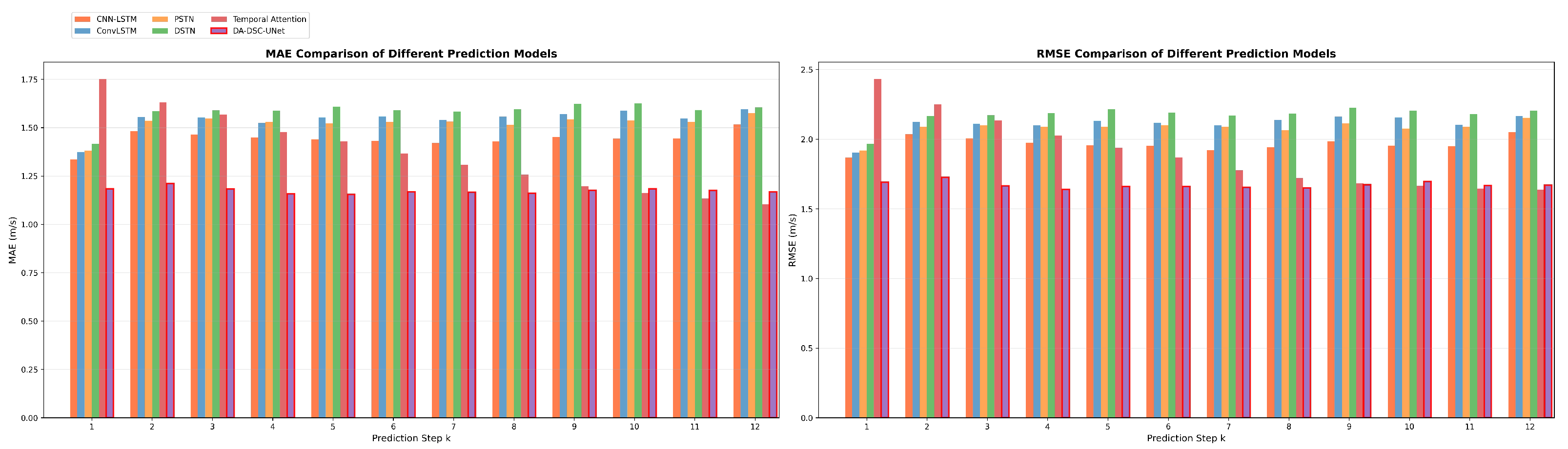
| Step k | CNN-LSTM | ConvLSTM | PSTN 1 | DSTN 2 | Temporal Attention | DA-DSC-UNet |
|---|---|---|---|---|---|---|
| 1 | 1.3350 | 1.3739 | 1.3804 | 1.4146 | 1.7512 | 1.1829 |
| 2 | 1.4823 | 1.5534 | 1.5349 | 1.5840 | 1.6317 | 1.2113 |
| 3 | 1.4654 | 1.5522 | 1.5473 | 1.5893 | 1.5666 | 1.1821 |
| 4 | 1.4481 | 1.5237 | 1.5298 | 1.5878 | 1.4779 | 1.1575 |
| 5 | 1.4387 | 1.5522 | 1.5213 | 1.6086 | 1.4292 | 1.1539 |
| 6 | 1.4302 | 1.5581 | 1.5307 | 1.5904 | 1.3663 | 1.1673 |
| 7 | 1.4195 | 1.5401 | 1.5316 | 1.5834 | 1.3074 | 1.1659 |
| 8 | 1.4288 | 1.5564 | 1.5138 | 1.5939 | 1.2563 | 1.1612 |
| 9 | 1.4518 | 1.5712 | 1.5432 | 1.6229 | 1.1972 | 1.1761 |
| 10 | 1.4432 | 1.5857 | 1.5363 | 1.6247 | 1.1623 | 1.1830 |
| 11 | 1.4437 | 1.5456 | 1.5299 | 1.5912 | 1.1329 | 1.1741 |
| 12 | 1.5161 | 1.5948 | 1.5742 | 1.6043 | 1.1032 | 1.1667 |
| Average | 1.4419 | 1.5423 | 1.5228 | 1.5829 | 1.3652 | 1.1735 |
| Step k | CNN-LSTM | ConvLSTM | PSTN | DSTN | Temporal Attention | DA-DSC-UNet |
|---|---|---|---|---|---|---|
| 1 | 1.8679 | 1.9028 | 1.9186 | 1.9655 | 2.4318 | 1.6908 |
| 2 | 2.0355 | 2.1230 | 2.0888 | 2.1652 | 2.2513 | 1.7254 |
| 3 | 2.0058 | 2.1111 | 2.0982 | 2.1715 | 2.1340 | 1.6646 |
| 4 | 1.9747 | 2.0988 | 2.0885 | 2.1867 | 2.0266 | 1.6396 |
| 5 | 1.9573 | 2.1321 | 2.0876 | 2.2143 | 1.9372 | 1.6600 |
| 6 | 1.9515 | 2.1185 | 2.0997 | 2.1893 | 1.8692 | 1.6599 |
| 7 | 1.9219 | 2.0988 | 2.0901 | 2.1699 | 1.7768 | 1.6535 |
| 8 | 1.9427 | 2.1384 | 2.0634 | 2.1842 | 1.7202 | 1.6491 |
| 9 | 1.9847 | 2.1607 | 2.1145 | 2.2248 | 1.6836 | 1.6730 |
| 10 | 1.9525 | 2.1557 | 2.0759 | 2.2054 | 1.6638 | 1.6966 |
| 11 | 1.9508 | 2.1026 | 2.0879 | 2.1795 | 1.6451 | 1.6671 |
| 12 | 2.0508 | 2.1656 | 2.1532 | 2.2022 | 1.6392 | 1.6703 |
| Average | 1.9663 | 2.1090 | 2.0805 | 2.1715 | 1.8982 | 1.6708 |
| Model | MAE | RMSE | Params | FLOPs | Infer. Time | Memory |
|---|---|---|---|---|---|---|
| (m/s) | (m/s) | (M) | (ms) | (MB) | ||
| UNet (Baseline) | 1.3512 | 1.7497 | 656,141 | 57.97 | 14.24 | 1024 |
| ECA-UNet | 1.3053 | 1.6966 | 656,153 | 58.04 | 14.85 | 1035 |
| CBAM-UNet | 1.3126 | 1.7022 | 656,533 | 58.04 | 15.10 | 1042 |
| ECA+CBAM-UNet | 1.2835 | 1.6901 | 656,545 | 58.11 | 15.42 | 1056 |
| DSC-UNet | 1.3501 | 1.7432 | 233,622 | 13.26 | 5.82 | 320 |
| ASPP-UNet | 1.2433 | 1.7162 | 1,132,045 | 61.35 | 22.56 | 1850 |
| ECA+CBAM+ASPP-UNet | 1.1857 | 1.6832 | 1,132,449 | 61.49 | 24.18 | 1920 |
| ECA+CBAM+DSC-UNet | 1.2776 | 1.6879 | 234,026 | 13.40 | 7.15 | 355 |
| DA-DSC-UNet (Ours) | 1.1735 | 1.6708 | 710,570 | 16.77 | 9.42 | 512 |
Disclaimer/Publisher’s Note: The statements, opinions and data contained in all publications are solely those of the individual author(s) and contributor(s) and not of MDPI and/or the editor(s). MDPI and/or the editor(s) disclaim responsibility for any injury to people or property resulting from any ideas, methods, instructions or products referred to in the content. |
© 2026 by the authors. Licensee MDPI, Basel, Switzerland. This article is an open access article distributed under the terms and conditions of the Creative Commons Attribution (CC BY) license.
Share and Cite
Shi, Y.; Huang, T.; Huang, L.; Huang, W.; Liu, S.; Chen, R. Spatiotemporal Prediction of Wind Fields in Coastal Urban Environments Using Multi-Source Satellite Data: A GeoAI Approach. Remote Sens. 2026, 18, 716. https://doi.org/10.3390/rs18050716
Shi Y, Huang T, Huang L, Huang W, Liu S, Chen R. Spatiotemporal Prediction of Wind Fields in Coastal Urban Environments Using Multi-Source Satellite Data: A GeoAI Approach. Remote Sensing. 2026; 18(5):716. https://doi.org/10.3390/rs18050716
Chicago/Turabian StyleShi, Yifan, Tianqiang Huang, Liqing Huang, Wei Huang, Shaoyu Liu, and Riqing Chen. 2026. "Spatiotemporal Prediction of Wind Fields in Coastal Urban Environments Using Multi-Source Satellite Data: A GeoAI Approach" Remote Sensing 18, no. 5: 716. https://doi.org/10.3390/rs18050716
APA StyleShi, Y., Huang, T., Huang, L., Huang, W., Liu, S., & Chen, R. (2026). Spatiotemporal Prediction of Wind Fields in Coastal Urban Environments Using Multi-Source Satellite Data: A GeoAI Approach. Remote Sensing, 18(5), 716. https://doi.org/10.3390/rs18050716