The Interplay Between Topographic Gradients and Lake Effects on the Spatiotemporal Dynamics of Surface Environmental Variables in the Qinghai Lake Riparian Zone


Highlights
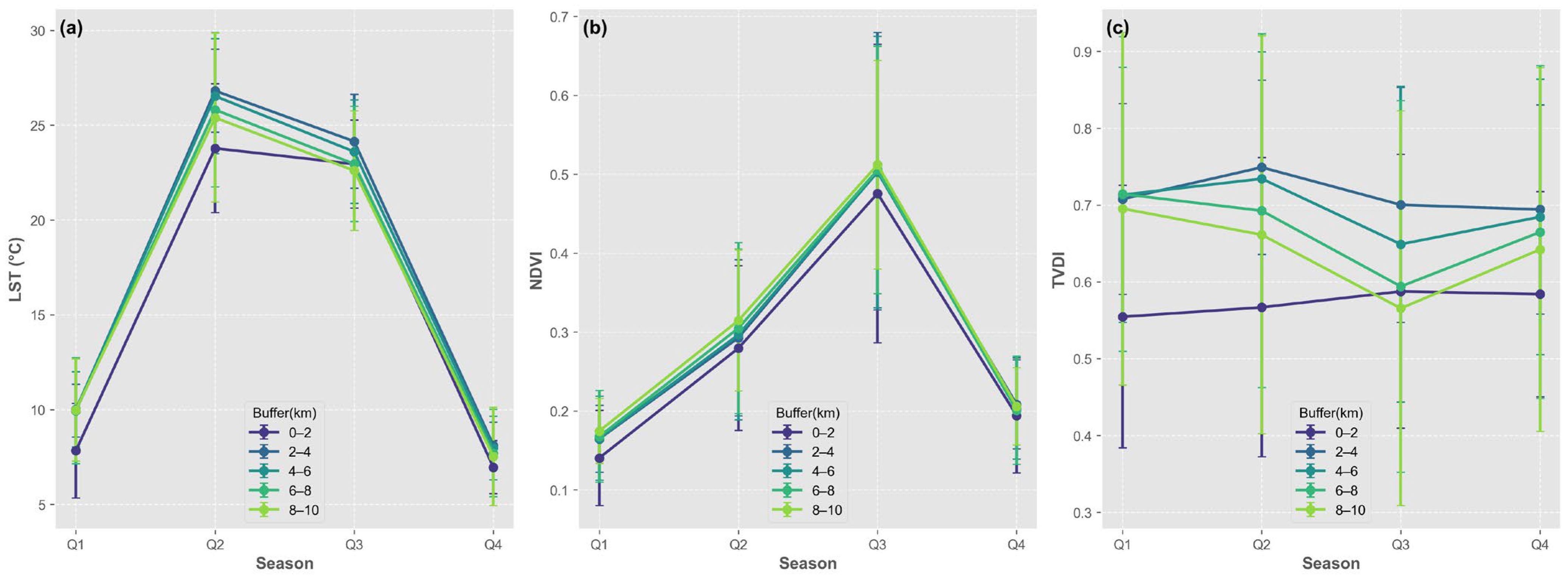
- We quantified multi-decadal (2000–2024) spatiotemporal dynamics of LST, NDVI, and TVDI, identifying a 0–2 km core buffer with dominant lacustrine cooling and humidifying effects.
- We demonstrated that topographic gradients significantly govern the spatial heterogeneity and intensity of lake effects across the 10-km riparian zone.
- It provides a quantitative framework for assessing the synergistic buffering capacity of large plateau lakes and complex terrain against climate change in fragile ecosystems.
- It offers scientific decision support for targeted ecological conservation and precision water resource management within plateau lake basins based on identified spatial thresholds.
Abstract
1. Introduction
2. Study Area and Methods
2.1. Study Area
2.2. Data Sources and Preprocessing
2.3. Methods
2.3.1. Research Framework
2.3.2. Spatial Gradient and Temporal Segmentation
2.3.3. Construction of the TVDI
2.3.4. Spatio-Temporal Trend and Gradient Analysis
2.3.5. Correlation with Topography
3. Results
3.1. Temporal Evolution Characteristics of the Surface Environment
3.1.1. Temporal Dynamics of LST
3.1.2. Temporal Dynamics of NDVI
3.1.3. Temporal Dynamics of TVDI
3.2. Statistical Distribution and Quarterly Variability Analysis
3.3. Characterization of Environmental Patterns
3.4. Interaction and Coupling Characteristics of Environmental Variables
3.5. Topographic Modulation of Surface Environmental Variables
4. Discussion
4.1. Mechanisms of Topographic Forcing on Environmental Variables Surrounding Qinghai Lake
4.2. Seasonal Rhythms and Spatio-Temporal Hydrothermal Regulation Mechanisms of Surface Environmental Variables
4.3. Evolution and Regime Shifts in the Basin Hydrological System Driven by Climate Warming and Humidification
5. Conclusions
- (1)
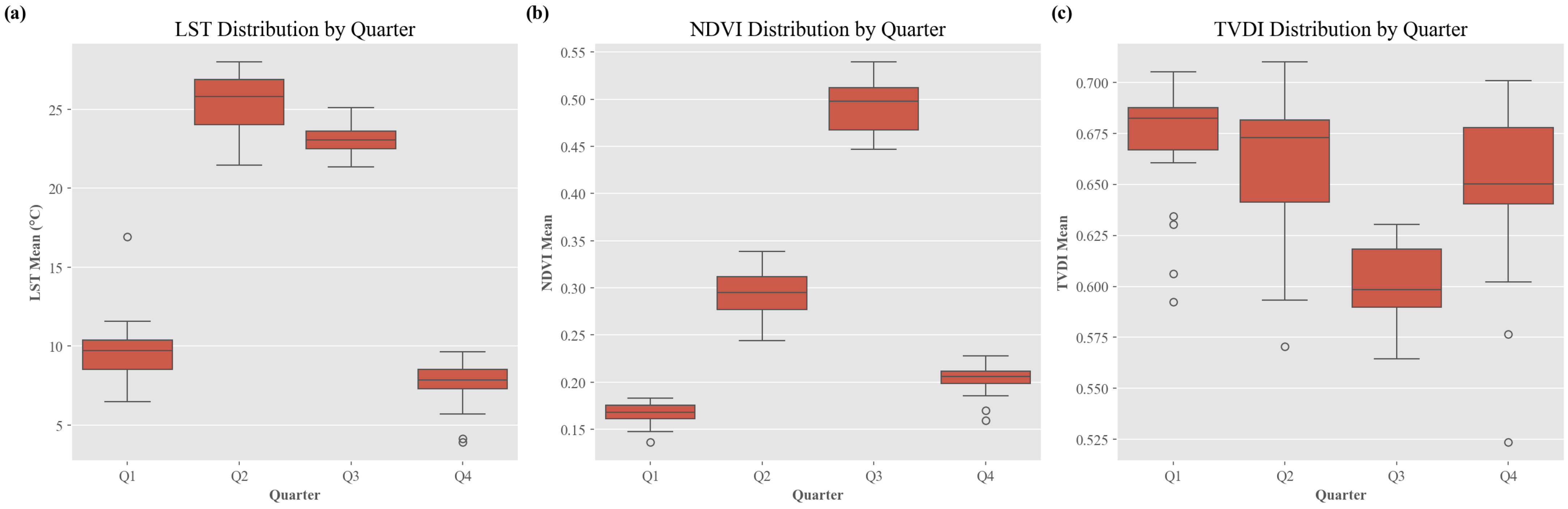
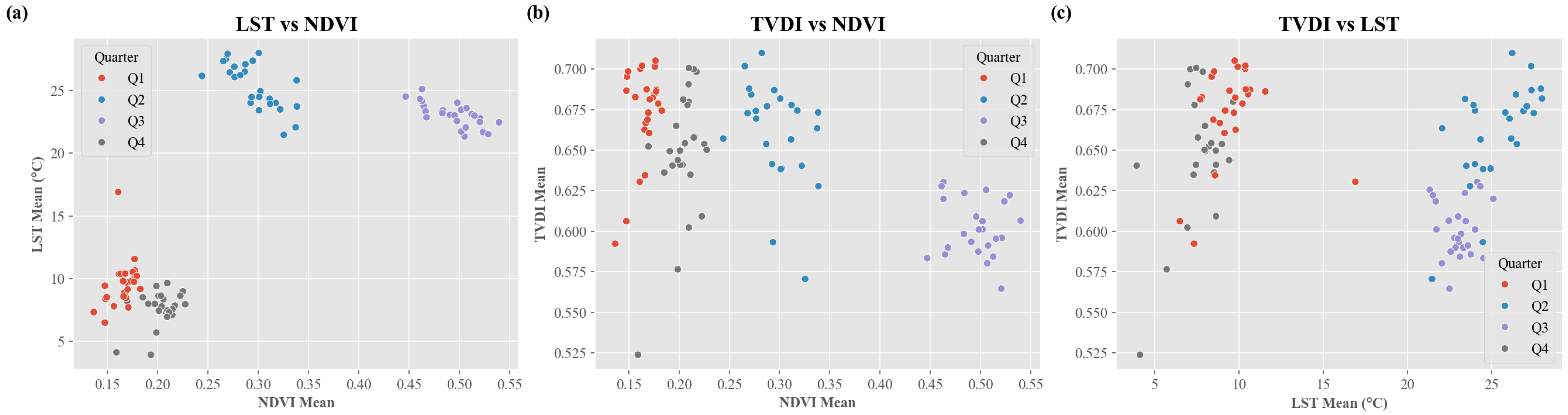
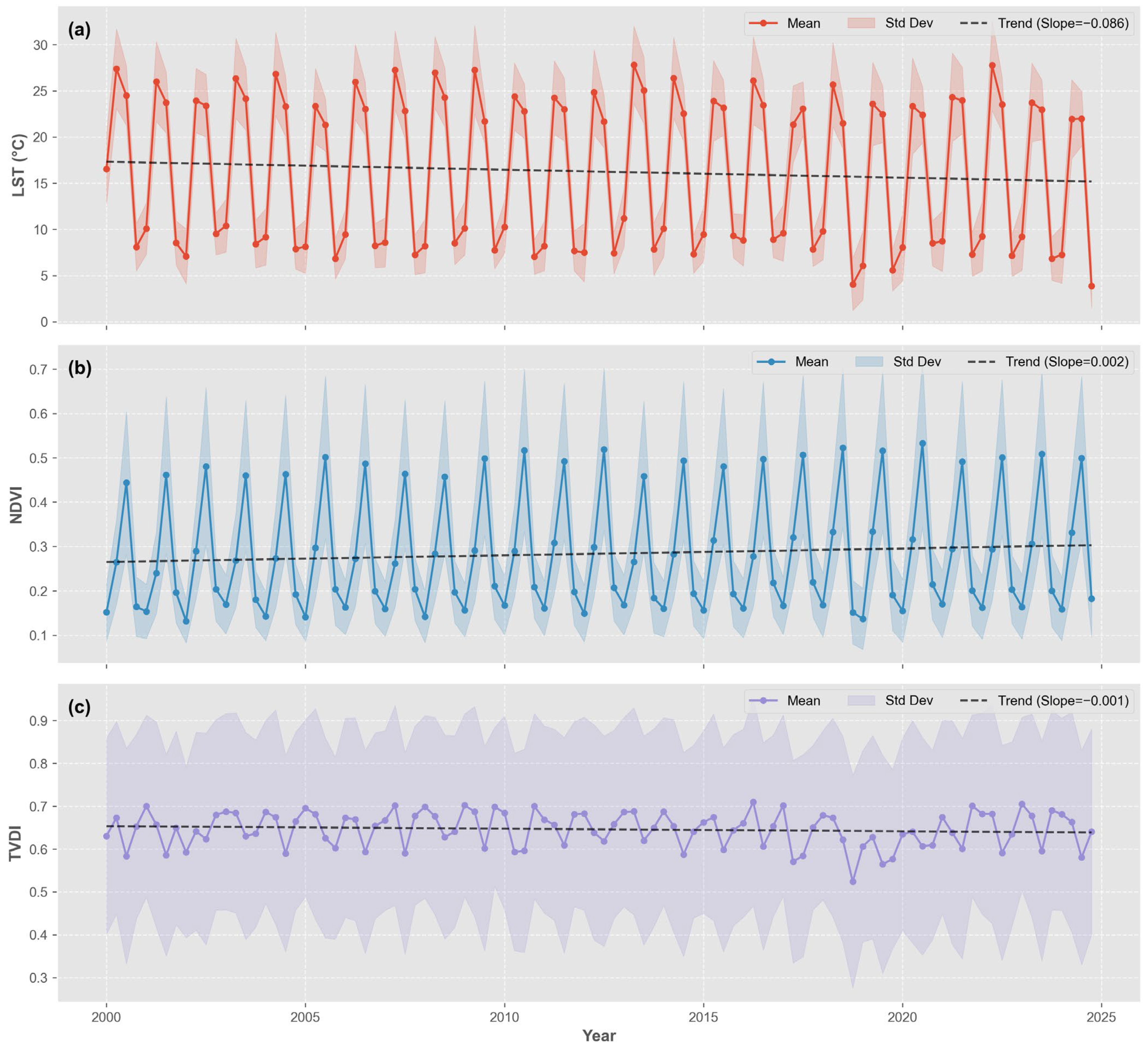
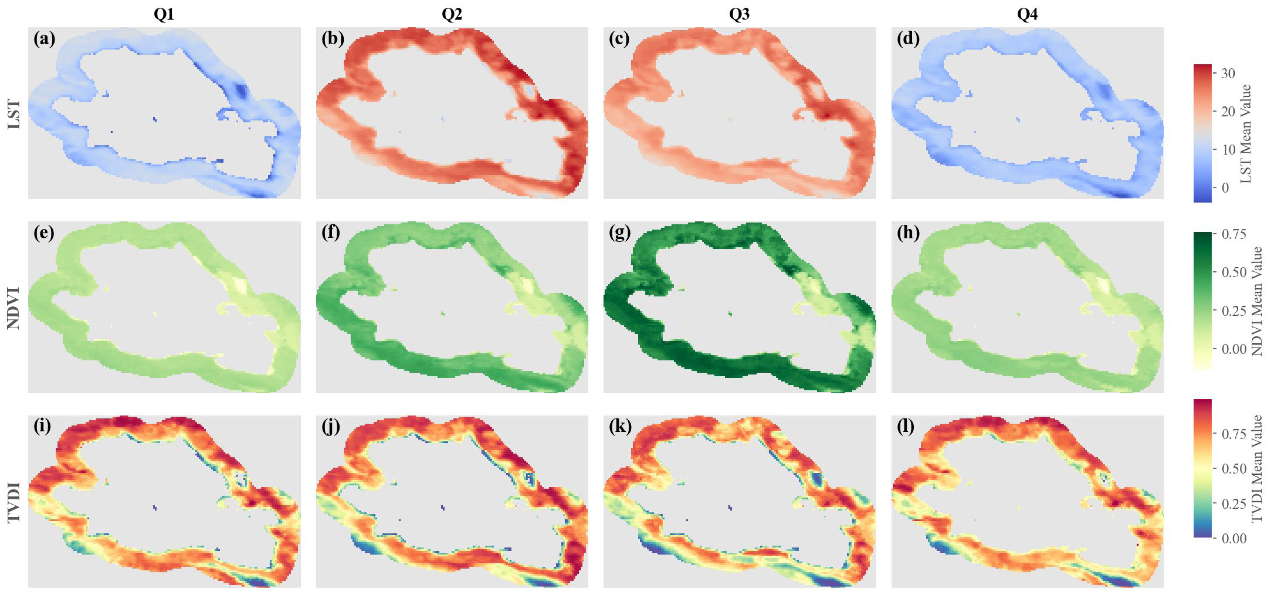
- Surface environmental variables exhibit pronounced seasonal differentiation and synergistic evolution. LST reaches its thermal peak in Q2, while NDVI achieves its phenological maximum in Q3, reflecting a lagged response of the alpine ecosystem to thermal activation thresholds. The quarterly evolution of TVDI reveals a transition from domain-wide moisture stress in Q2 to seasonal drought mitigation in Q3. Bivariate coupling analysis confirms that once thermal requirements are met, the improvement of moisture conditions in summer serves as the key contributing factor for overcoming the vegetation growth bottleneck.
- (2)
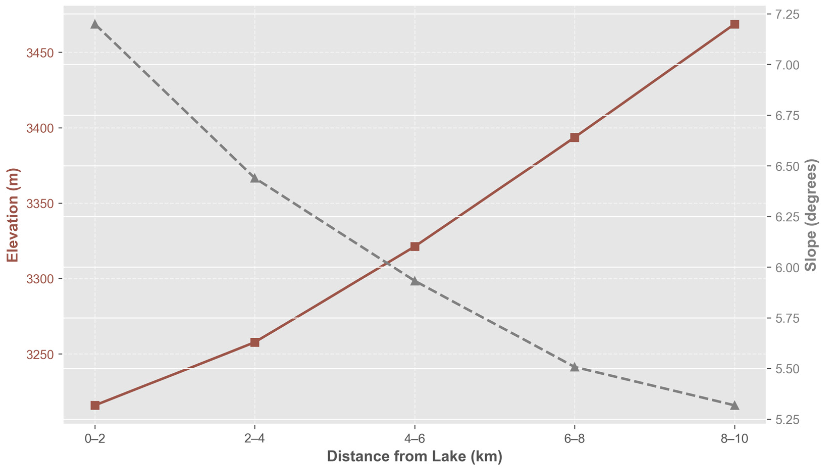
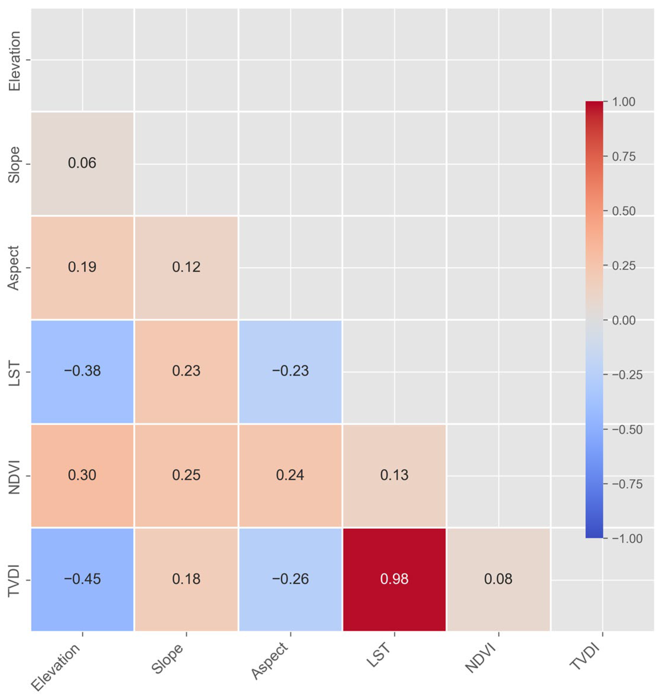
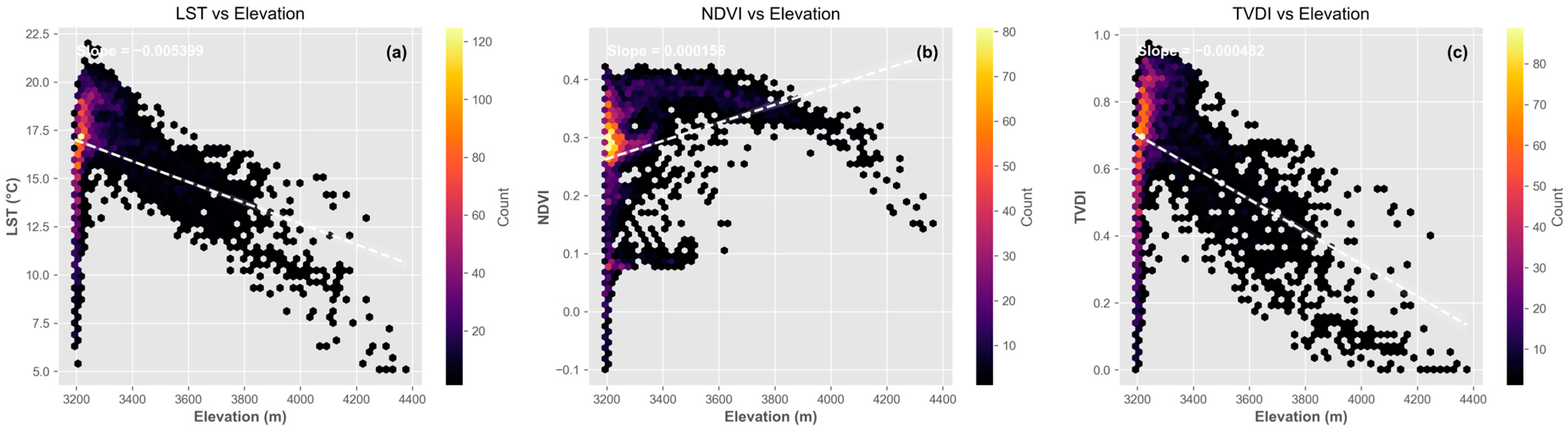
- Topographic configurations and lake effects collectively shape regional microclimatic gradients. Topography drives heat redistribution via vertical lapse rates (r = −0.38 between LST and elevation) and facilitates moisture convergence through gradual slopes (r = −0.45 between TVDI and elevation). Simultaneously, the lake is associated with a significant summer cooling and humidifying effect, establishing a 0–2 km near-shore regulatory zone. In contrast, distal areas (8–10 km) are more strongly influenced by topographic-mediated cold-moist effects, constructing a composite landscape of “near-shore stability and distal optimization.”
- (3)
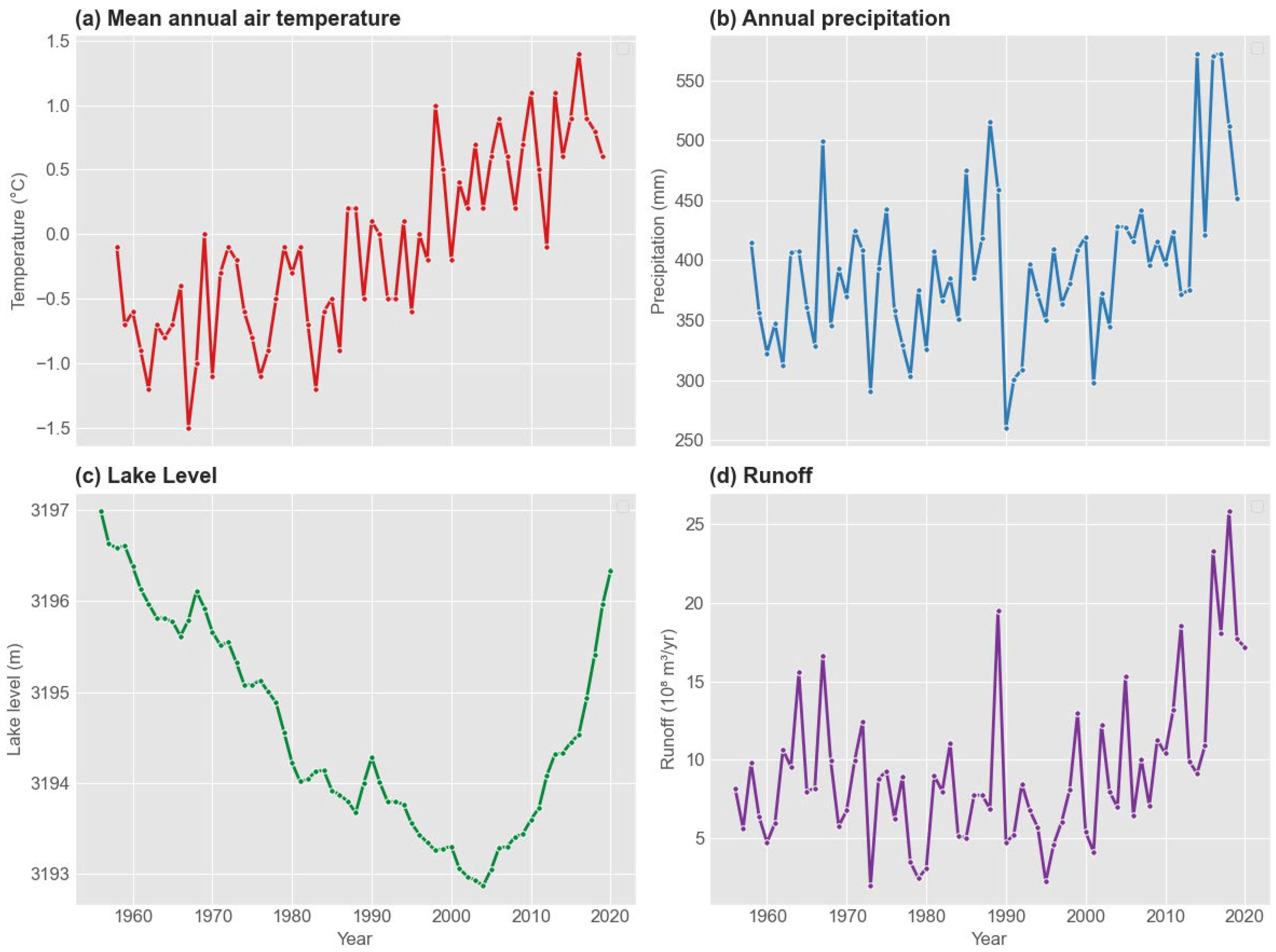
- Climate warming and humidification have co-occurred with a regime shift in the basin’s hydrological system. Since 2004, the water level of Qinghai Lake has transitioned from a prolonged decline to a rapid recovery, a hydrological shift synchronized with regional increases in temperature and precipitation. Large-scale warming and wetting have contributed to reshaped the basin’s hydrothermal balance by enhancing recharge efficiency in high-altitude regions. This profound structural adjustment indicates that the Qinghai Lake basin is undergoing a process of habitat reorganization and transition from contraction to expansion.
Supplementary Materials
Author Contributions
Funding
Data Availability Statement
Conflicts of Interest
References
- Chen, D.; Xu, B.; Yao, T.; Guo, Z.; Cui, P.; Chen, F.; Zhang, R.; Zhang, X.; Zhang, Y.; Fan, J.; et al. Assessment of past, present and future environmental changes on the Tibetan Plateau. Chin. Sci. Bull. 2015, 60, 3025–3035. [Google Scholar] [CrossRef] [Scilit]
- Li, X.; Cheng, G.D.; Jin, H.J.; Kang, E.; Che, T.; Jin, R.; Wu, L.Z.; Nan, Z.T.; Wang, J.; Shen, Y.P. Cryospheric change in China. Global Planet. Change 2008, 62, 210–218. [Google Scholar] [CrossRef] [Scilit]
- Peng, J.; Liu, Z.H.; Liu, Y.H.; Wu, J.S.; Han, Y.A. Trend analysis of vegetation dynamics in Qinghai-Tibet Plateau using Hurst Exponent. Ecol. Indic. 2012, 14, 28–39. [Google Scholar] [CrossRef] [Scilit]
- Ji, J.F.; Shen, J.; Balsam, W.; Chen, J.; Liu, L.W.; Liu, X.Q. Asian monsoon oscillations in the northeastern Qinghai-Tibet Plateau since the late glacial as interpreted from visible reflectance of Qinghai Lake sediments. Earth Planet. Sci. Lett. 2005, 233, 61–70. [Google Scholar] [CrossRef] [Scilit]
- Huang, K.; Zhang, Y.J.; Zhu, J.T.; Liu, Y.J.; Zu, J.X.; Zhang, J. The Influences of Climate Change and Human Activities on Vegetation Dynamics in the Qinghai-Tibet Plateau. Remote Sens. 2016, 8, 876. [Google Scholar] [CrossRef] [Scilit]
- Wang, Y.; Ren, Z.; Ma, P.P.; Wang, Z.M.; Niu, D.C.; Fu, H.; Elser, J.J. Effects of grassland degradation on ecological stoichiometry of soil ecosystems on the Qinghai-Tibet Plateau. Sci. Total Environ. 2020, 722, 137910. [Google Scholar] [CrossRef] [Scilit]
- Chen, F.H.; Wu, D.; Chen, J.H.; Zhou, A.F.; Yu, J.Q.; Shen, J.; Wang, S.M.; Huang, X.Z. Holocene moisture and East Asian summer monsoon evolution in the northeastern Tibetan Plateau recorded by Lake Qinghai and its environs: A review of conflicting proxies. Quat. Sci. Rev. 2016, 154, 111–129. [Google Scholar] [CrossRef] [Scilit]
- Liu, X.J.; Colman, S.M.; Brown, E.T.; Henderson, A.C.G.; Werne, J.P.; Holmes, J.A. Abrupt deglaciation on the northeastern Tibetan Plateau: Evidence from Lake Qinghai. J. Paleolimnol. 2014, 51, 223–240. [Google Scholar] [CrossRef] [Scilit]
- Li, X.Y.; Xu, H.Y.; Sun, Y.L.; Zhang, D.S.; Yang, Z.P. Lake-level change and water balance analysis at lake qinghai, west China during recent decades. Water Resour. Manag. 2007, 21, 1505–1516. [Google Scholar] [CrossRef] [Scilit]
- Fan, C.Y.; Song, C.Q.; Li, W.K.; Liu, K.; Cheng, J.; Fu, C.S.; Chen, T.; Ke, L.H.; Wang, J.D. What drives the rapid water-level recovery of the largest lake (Qinghai Lake) of China over the past half century? J. Hydrol. 2021, 593, 125921. [Google Scholar] [CrossRef] [Scilit]
- Luo, D.L.; Jin, H.J.; Marchenko, S.S.; Romanovsky, V.E. Difference between near-surface air, land surface and ground surface temperatures and their influences on the frozen ground on the Qinghai-Tibet Plateau. Geoderma 2018, 312, 74–85. [Google Scholar] [CrossRef] [Scilit]
- Luo, L.H.; Ma, W.; Zhuang, Y.L.; Zhang, Y.N.; Yi, S.H.; Xu, J.W.; Long, Y.P.; Ma, D.; Zhang, Z.Q. The impacts of climate change and human activities on alpine vegetation and permafrost in the Qinghai-Tibet Engineering Corridor. Ecol. Indic. 2018, 93, 24–35. [Google Scholar] [CrossRef] [Scilit]
- Zhang, S.Z.; Wu, S.F.; Ding, Z.K.; Niu, F.J.; Mu, Y.H. Local Surface Environmental Changes in a Basin in the Permafrost Region of Qinghai-Tibet Plateau Affected by Lake Outburst Event. Remote Sens. 2025, 17, 3392. [Google Scholar] [CrossRef] [Scilit]
- Zhang, G.Q.; Xie, H.J.; Yao, T.D.; Li, H.Y.; Duan, S.Q. Quantitative water resources assessment of Qinghai Lake basin using Snowmelt Runoff Model (SRM). J. Hydrol. 2014, 519, 976–987. [Google Scholar] [CrossRef] [Scilit]
- Zhang, W.Z.; Wang, S.L.; Zhang, B.; Zhang, F.F.; Shen, Q.; Wu, Y.H.; Mei, Y.; Qiu, R.T.; Li, J.S. Analysis of the water color transitional change in Qinghai Lake during the past 35 years observed from Landsat and MODIS. J. Hydrol. Reg. Stud. 2022, 42, 101154. [Google Scholar] [CrossRef] [Scilit]
- Li, Z.H.; Zhang, Z.J.; Xiong, S.Q.; Zhang, W.C.; Li, R. Lake Surface Temperature Predictions under Different Climate Scenarios with Machine Learning Methods: A Case Study of Qinghai Lake and Hulun Lake, China. Remote Sens. 2024, 16, 3220. [Google Scholar] [CrossRef] [Scilit]
- Li, Z.H.; Zhang, Z.J.; Zhang, W.C.; Li, Y.L. Modeling the lake water balance of a closed alpine basin using a fully distributed hydrological framework: A case study of Qinghai Lake, China. J. Hydrol. 2026, 666, 134824. [Google Scholar] [CrossRef] [Scilit]
- Li, M.; Wang, G.J.; Sun, A.H.; Wang, Y.K.; Li, F.; Liang, S.H. Monitoring Grassland Variation in a Typical Area of the Qinghai Lake Basin Using 30 m Annual Maximum NDVI Data. Remote Sens. 2024, 16, 1222. [Google Scholar] [CrossRef] [Scilit]
- Wang, X.L.; Liang, T.G.; Xie, H.J.; Huang, X.D.; Lin, H.L. Climate-driven changes in grassland vegetation, snow cover, and lake water of the Qinghai Lake basin. J. Appl. Remote Sens. 2016, 10, 036017. [Google Scholar] [CrossRef] [Scilit]
- Meng, S.J.; Tang, Z.Y.; Xue, Y.; Wu, X.T.; Li, C.G.; Wu, X.H. Relationship between Area Changes of Key Lakes and Evapotranspiration in Qinghai Province. Atmosphere 2024, 15, 1210. [Google Scholar] [CrossRef] [Scilit]
- Hou, P.F.; Qiu, S.K.; Wang, J.X.; Zhang, H.C.; Du, J. Long-term water level variations in Lake Qinghai and their climatic and human activities driving mechanisms. J. Hydrol. Reg. Stud. 2025, 61, 102755. [Google Scholar] [CrossRef] [Scilit]
- Zhang, G.Q.; Xie, H.J.; Duan, S.Q.; Tian, M.Z.; Yi, D.H. Water level variation of Lake Qinghai from satellite and ments under climate change. J. Appl. Remote Sens. 2011, 5, 053532. [Google Scholar] [CrossRef] [Scilit]
- Zhu, H.; Chen, K.J.; Li, M.J.; Hu, S.Q.; Zhang, G.Q.; Kuang, X.X.; Cui, W.F.; Zhang, S.P.; Liu, J.G. Terrestrial Water Storage Changes of Qinghai Lake on the Tibetan Plateau From Joint Inversion of GNSS and InSAR Data. Water Resour. Res. 2025, 61, e2024WR039503. [Google Scholar] [CrossRef] [Scilit]
- Fang, J.M.; Li, G.J.; Rubinato, M.; Ma, G.Q.; Zhou, J.X.; Jia, G.D.; Yu, X.X.; Wang, H.N. Analysis of Long-Term Water Level Variations in Qinghai Lake in China. Water 2019, 11, 2136. [Google Scholar] [CrossRef] [Scilit]
- Ma, Y.J.; Li, X.Y.; Liu, L.; Huang, Y.M.; Li, Z.; Hu, X.; Wu, X.C.; Yang, X.F.; Wang, P.; Zhao, S.J.; et al. Measurements and Modeling of the Water Budget in Semiarid High-Altitude Qinghai Lake Basin, Northeast Qinghai-Tibet Plateau. J. Geophys. Res-Atmos. 2018, 123, 10857–10871. [Google Scholar] [CrossRef] [Scilit]
- Wang, H.Y.; Dong, H.L.; Zhang, C.L.L.; Jiang, H.C.; Zhao, M.X.; Liu, Z.H.; Lai, Z.P.; Liu, W.G. Water depth affecting thaumarchaeol production in Lake Qinghai, northeastern Qinghai-Tibetan plateau: Implications for paleo lake levels and paleoclimate. Chem. Geol. 2014, 368, 76–84. [Google Scholar] [CrossRef] [Scilit]
- Tang, L.Y.; Duan, X.F.; Kong, F.J.; Zhang, F.; Zheng, Y.F.; Li, Z.; Mei, Y.; Zhao, Y.W.; Hu, S.J. Influences of climate change on area variation of Qinghai Lake on Qinghai-Tibetan Plateau since 1980s. Sci. Rep. 2018, 8, 7331. [Google Scholar] [CrossRef] [Scilit]
- Zhao, H.C.; Li, Y.; Chen, X.G.; Wang, H.R.; Yao, N.; Liu, F.G. Monitoring monthly soil moisture conditions in China with temperature vegetation dryness indexes based on an enhanced vegetation index and normalized difference vegetation index. Theor. Appl. Climatol. 2021, 143, 159–176. [Google Scholar] [CrossRef] [Scilit]
- Yuan, Y.P.; Ye, X.C.; Liu, T.T.; Li, X.H. Drought monitoring based on temperature vegetation dryness index and its relationship with anthropogenic pressure in a subtropical humid watershed in China. Ecol. Indic. 2023, 154, 110584. [Google Scholar] [CrossRef] [Scilit]
- Swift, L.W. Algorithm for Solar-Radiation on Mountain Slopes. Water Resour. Res. 1976, 12, 108–112. [Google Scholar] [CrossRef] [Scilit]
- Zhang, T.Q.; Yu, W.B.; Lu, Y.; Chen, L. Identification and Correlation Analysis of Engineering Environmental Risk Factors along the Qinghai-Tibet Engineering Corridor. Remote Sens. 2022, 14, 908. [Google Scholar] [CrossRef] [Scilit]
- Huang, F.; Chunyu, X.Z.; Wang, Y.K.; Zhang, X.; Qian, B.; Zhao, D.Y.; Xia, Z.Q. Impacts of Streamflow and Topographic Changes on Water Level during the Dry Season of Poyang Lake, China. J. Hydrol. Eng. 2020, 25, 05020001. [Google Scholar] [CrossRef] [Scilit]
- Sandholt, I.; Rasmussen, K.; Andersen, J. A simple interpretation of the surface temperature/vegetation index space for assessment of surface moisture status. Remote Sens. Environ. 2002, 79, 213–224. [Google Scholar] [CrossRef] [Scilit]
- Zhang, G.; Duan, S. Lakes as sentinels of climate change on the Tibetan Plateau. All Earth 2021, 33, 161–165. [Google Scholar] [CrossRef] [Scilit]






Disclaimer/Publisher’s Note: The statements, opinions and data contained in all publications are solely those of the individual author(s) and contributor(s) and not of MDPI and/or the editor(s). MDPI and/or the editor(s) disclaim responsibility for any injury to people or property resulting from any ideas, methods, instructions or products referred to in the content. |
© 2026 by the authors. Licensee MDPI, Basel, Switzerland. This article is an open access article distributed under the terms and conditions of the Creative Commons Attribution (CC BY) license.
Share and Cite
Li, F.; Liu, M.; Ding, Z.; Shi, C.; Zhou, M.; Guo, Y. The Interplay Between Topographic Gradients and Lake Effects on the Spatiotemporal Dynamics of Surface Environmental Variables in the Qinghai Lake Riparian Zone. Remote Sens. 2026, 18, 620. https://doi.org/10.3390/rs18040620
Li F, Liu M, Ding Z, Shi C, Zhou M, Guo Y. The Interplay Between Topographic Gradients and Lake Effects on the Spatiotemporal Dynamics of Surface Environmental Variables in the Qinghai Lake Riparian Zone. Remote Sensing. 2026; 18(4):620. https://doi.org/10.3390/rs18040620
Chicago/Turabian StyleLi, Fei, Minghao Liu, Zekun Ding, Chen Shi, Maoding Zhou, and Yafeng Guo. 2026. "The Interplay Between Topographic Gradients and Lake Effects on the Spatiotemporal Dynamics of Surface Environmental Variables in the Qinghai Lake Riparian Zone" Remote Sensing 18, no. 4: 620. https://doi.org/10.3390/rs18040620
APA StyleLi, F., Liu, M., Ding, Z., Shi, C., Zhou, M., & Guo, Y. (2026). The Interplay Between Topographic Gradients and Lake Effects on the Spatiotemporal Dynamics of Surface Environmental Variables in the Qinghai Lake Riparian Zone. Remote Sensing, 18(4), 620. https://doi.org/10.3390/rs18040620