Improved UCTransNet by Integrating Pyramid Kernel Interaction with Triplet Attention for Identifying Multi-Scale Landslides from GF-2 Imagery

 ,
,
Highlights
- The proposed UCTransNet-TPKI model integrates Pyramid Kernel Interaction and Triplet Attention to effectively distinguish small-scale landslides from bare soil interference.
- The method achieved state-of-the-art accuracy (F1-score 0.9008) on high-resolution GF-2 imagery, outperforming MFFENet, TransLandSeg, and Segformer++ in complex mountainous terrains.
- This framework provides a robust automated solution for rapid post-disaster landslide mapping and geological hazard risk assessment in spectrally complex regions.
- The successful synergistic integration of multi-scale convolution and cross-dimensional attention offers a transferable technical reference for solving the “same spectrum, different objects” challenge in remote sensing.
Abstract
1. Introduction
2. Study Area and Data
2.1. Study Area
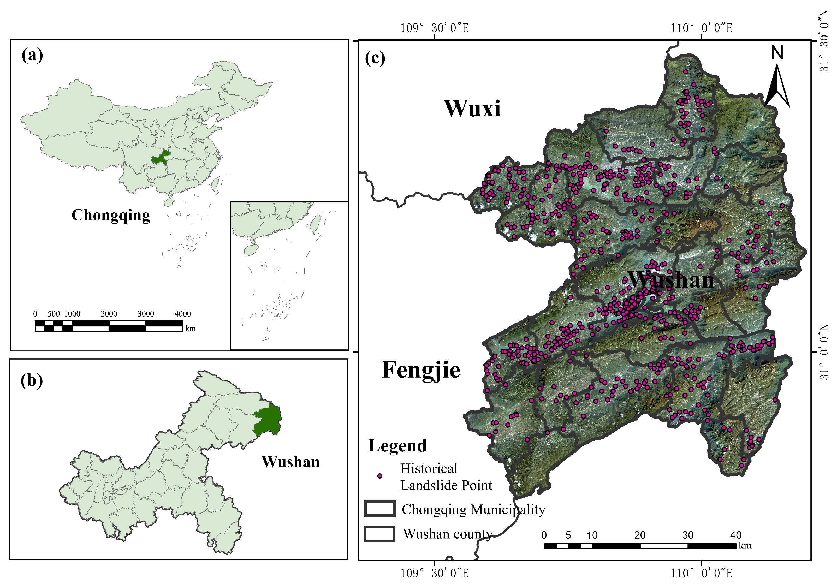
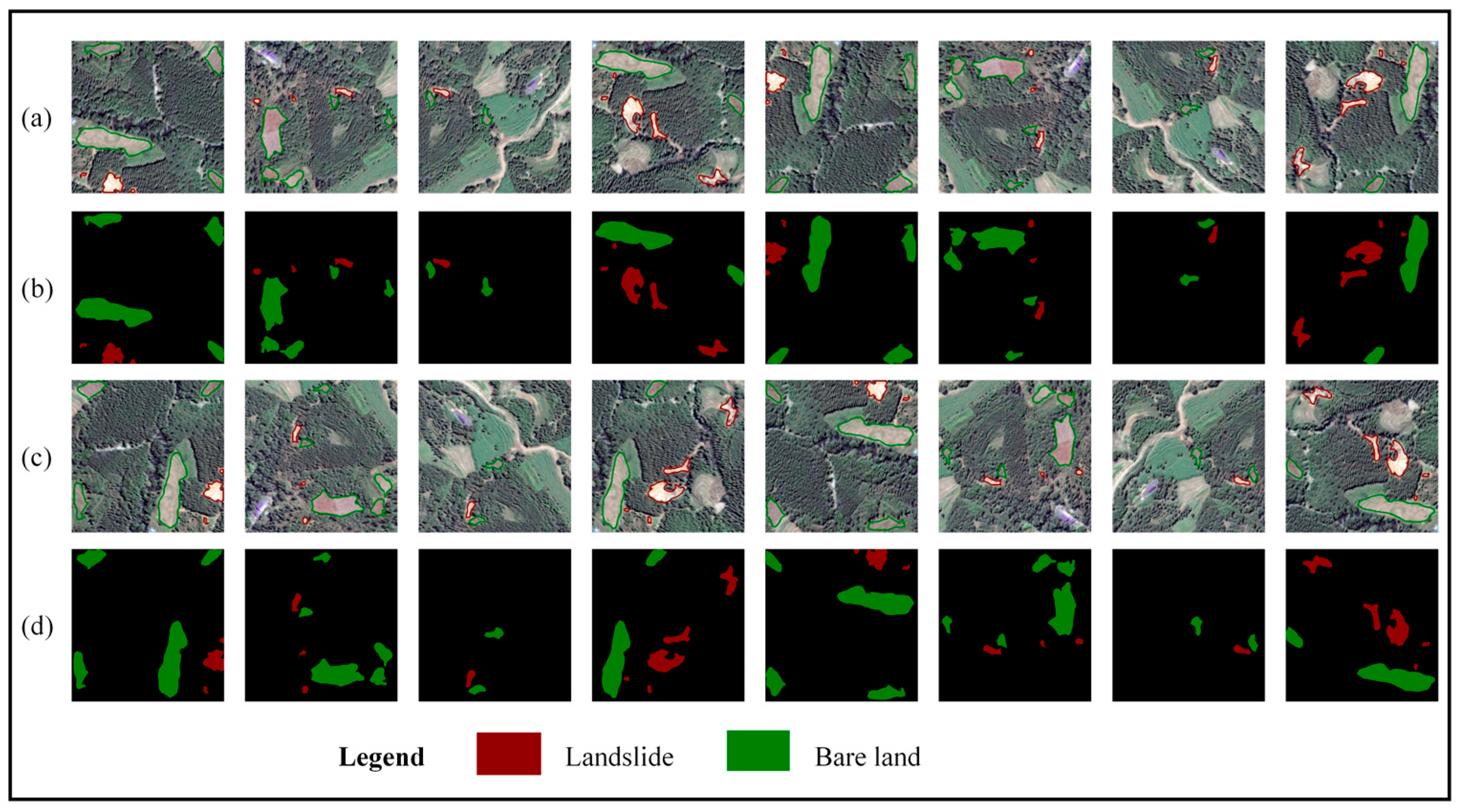
2.2. Experimental Data
3. Method
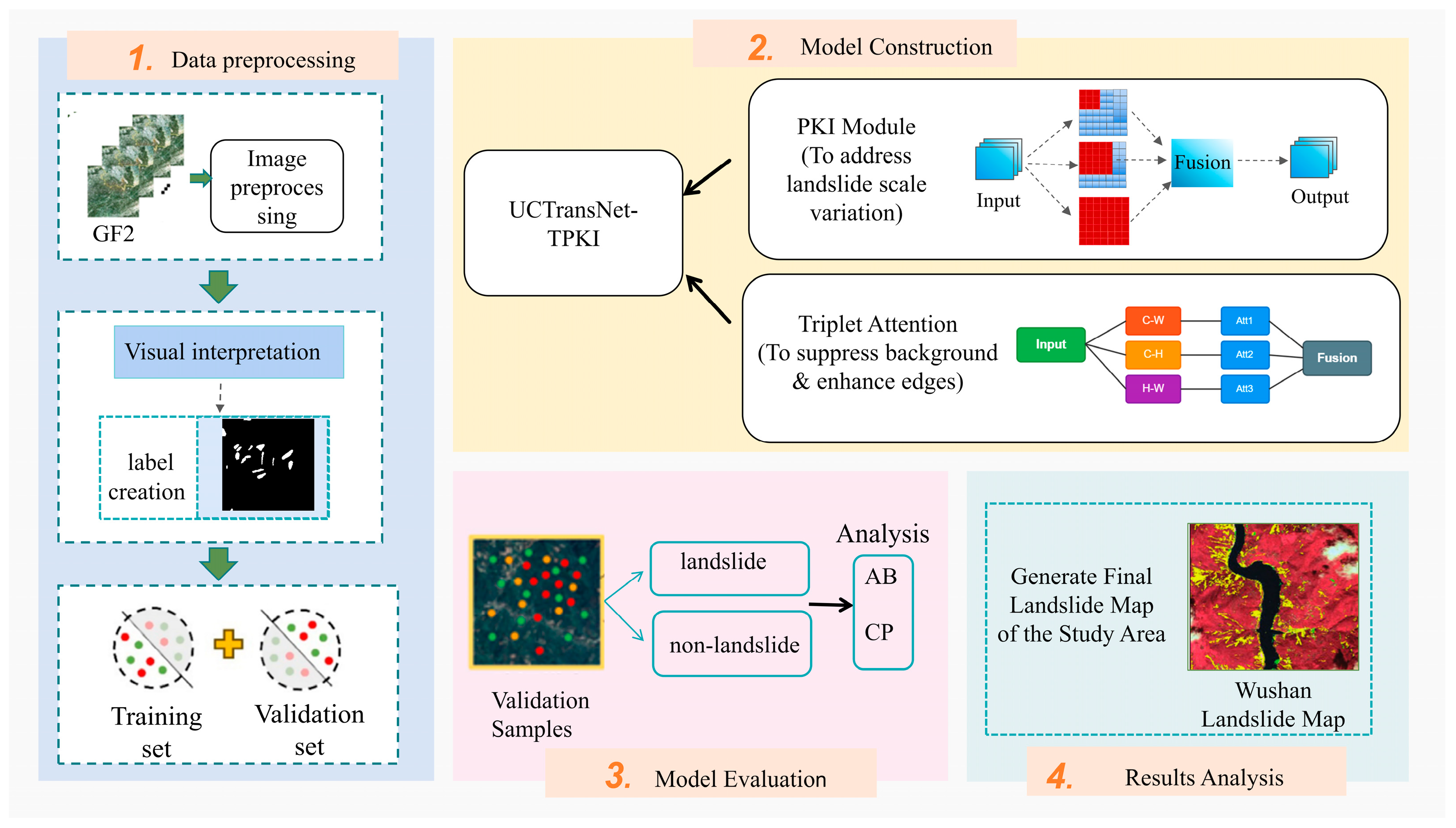
3.1. Model Construction
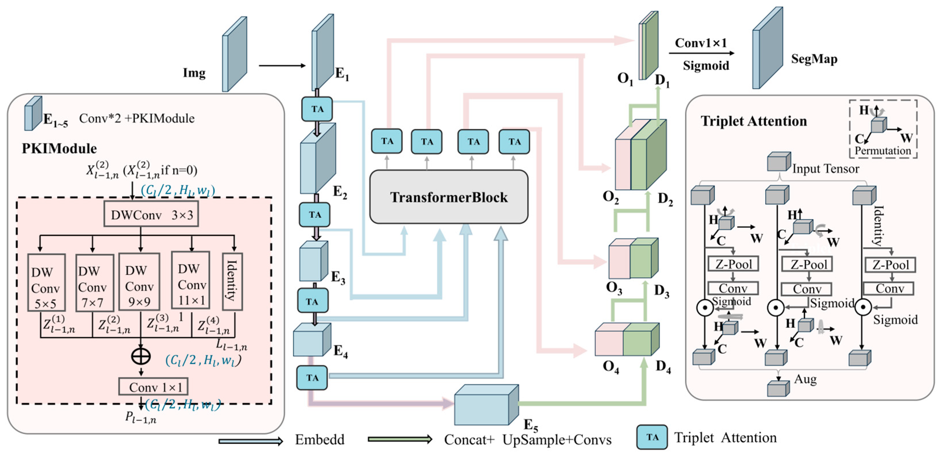
3.1.1. Original UCTransNet Architecture
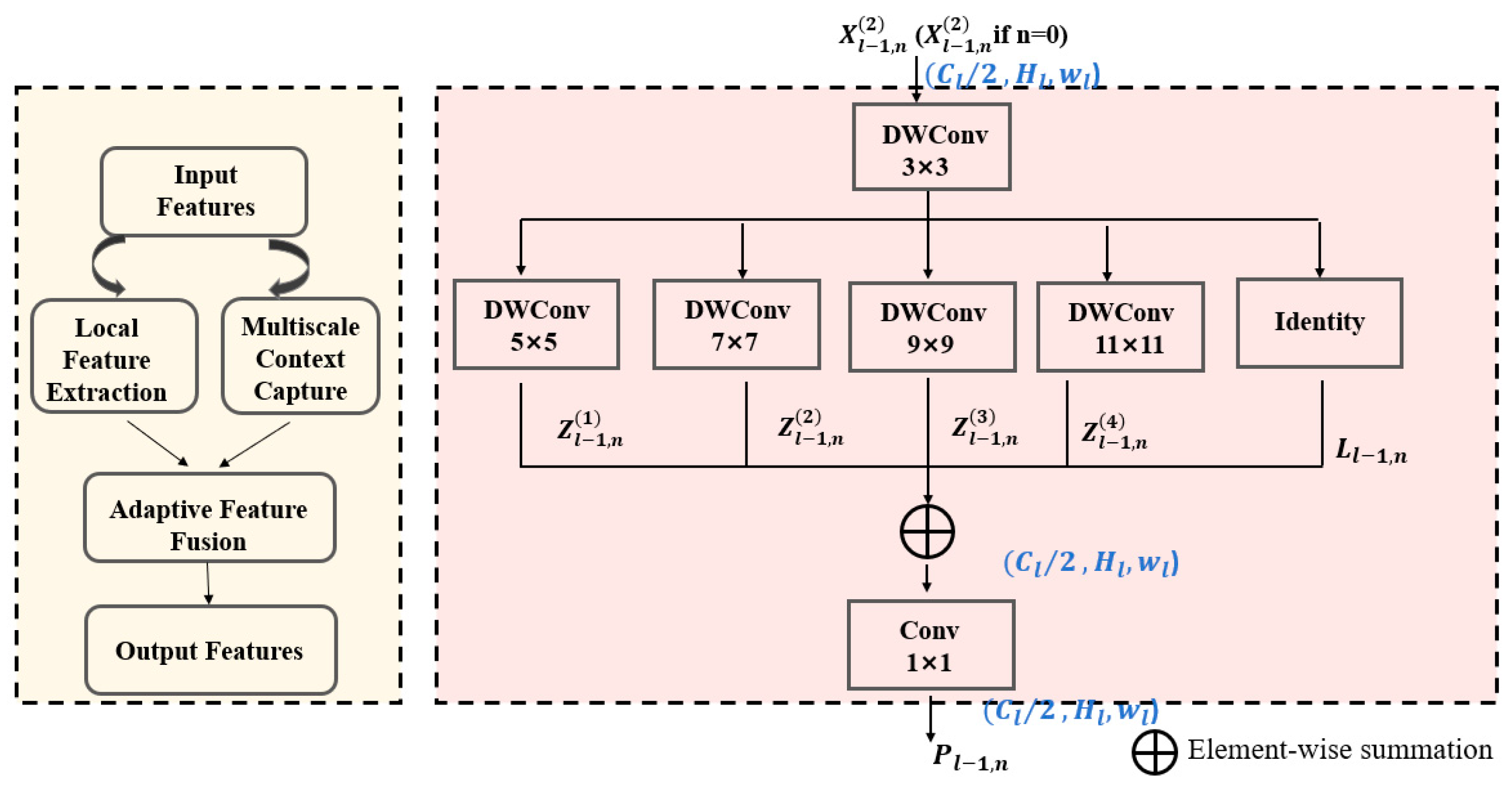
3.1.2. Pyramid Kernel Interaction (PKI) Module for Multi-Scale Feature Fusion
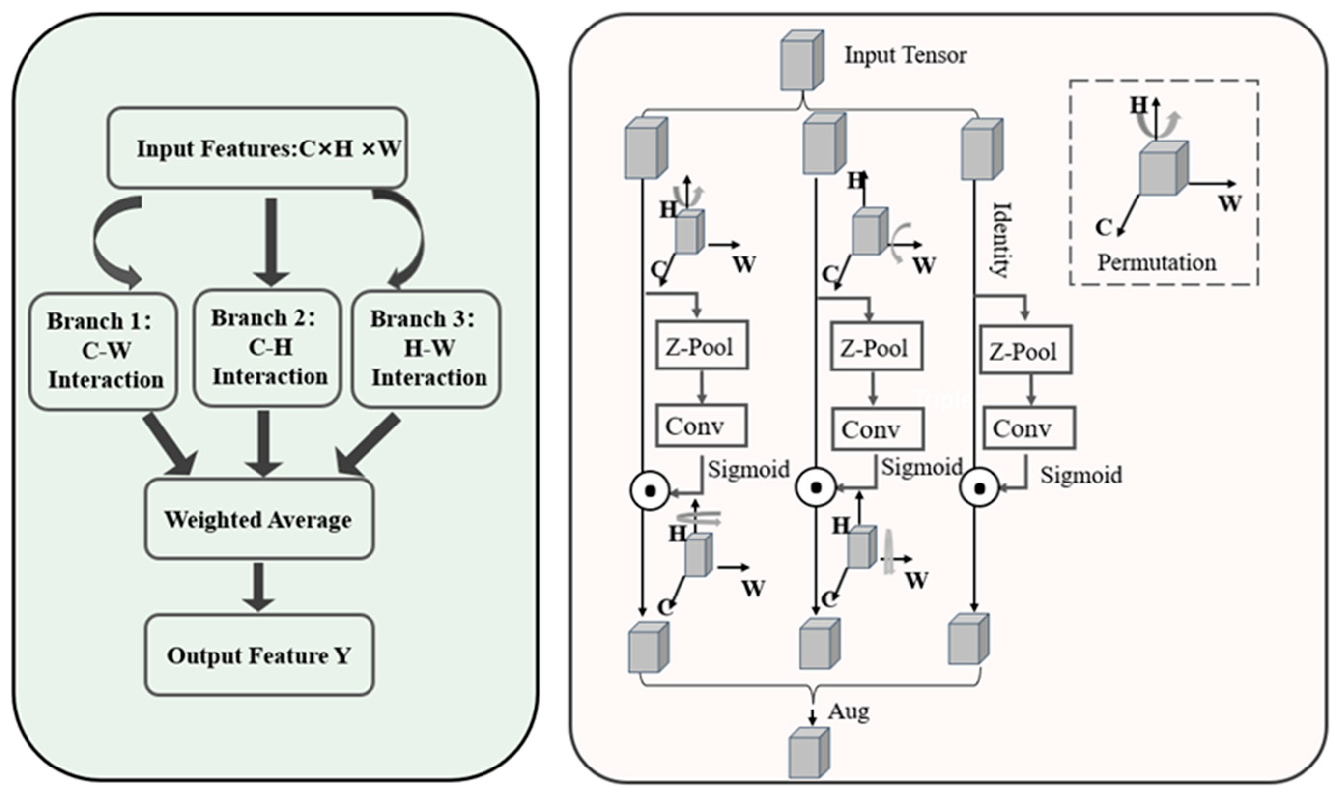
3.1.3. Triplet Attention for Suppressing Ambiguous Backgrounds and Enhancing Weak Features
3.1.4. The Encoder
3.1.5. The Decoder
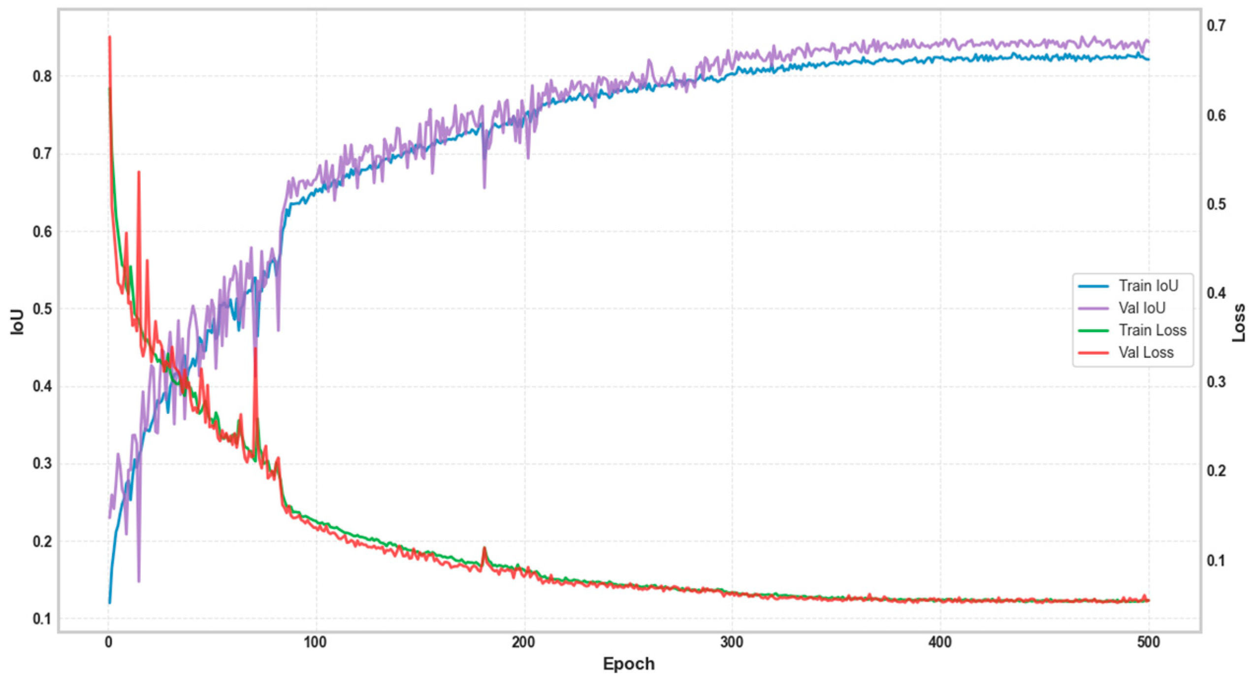
3.2. Model Training and Implementation
3.3. Performance Evaluation Metrics
- (1)
- Precision: This denotes the proportion of accurately detected positive examples among all instances projected as positive for a particular class. The calculation is performed as follows:
- (2)
- Recall: Denotes the ratio of samples predicted as positive for each class to the actual positive samples for that class in the labeled dataset, computed using the subsequent formula:
- (3)
- F1-Score: Provides a balance between accuracy and recall by taking the harmonic mean of the two measures. The formula is as follows:
- (4)
- Intersection over Union (IoU): Representing the degree of overlap between the actual labeled region and the predicted region, calculated using the following formula:
4. Results
4.1. Ablation Study
- (1)
- Full model experiment
- (2)
- Without the Triplet Attention module
- (3)
- Without the PKI module
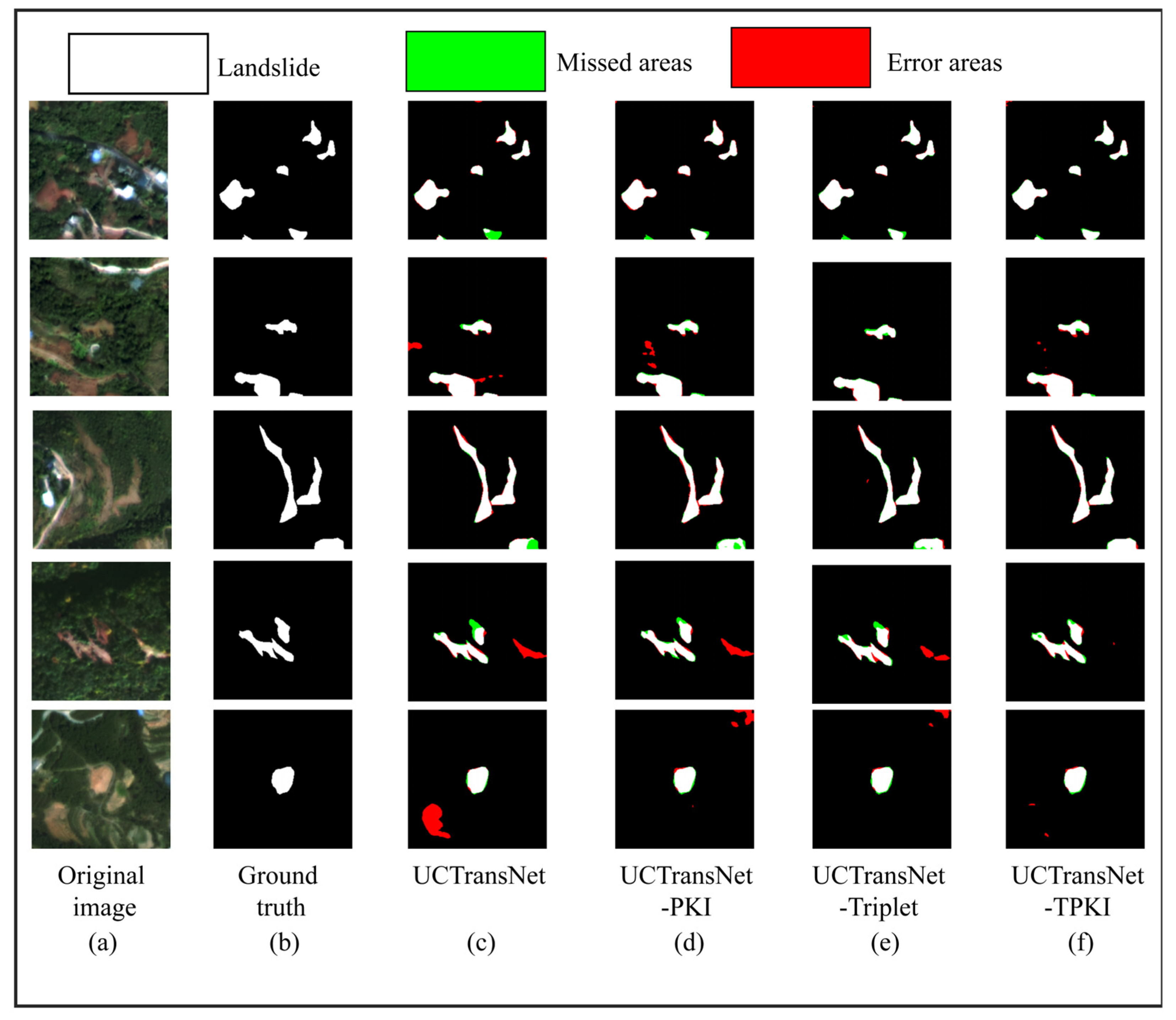
4.1.1. Ablation Study on Wushan Dataset
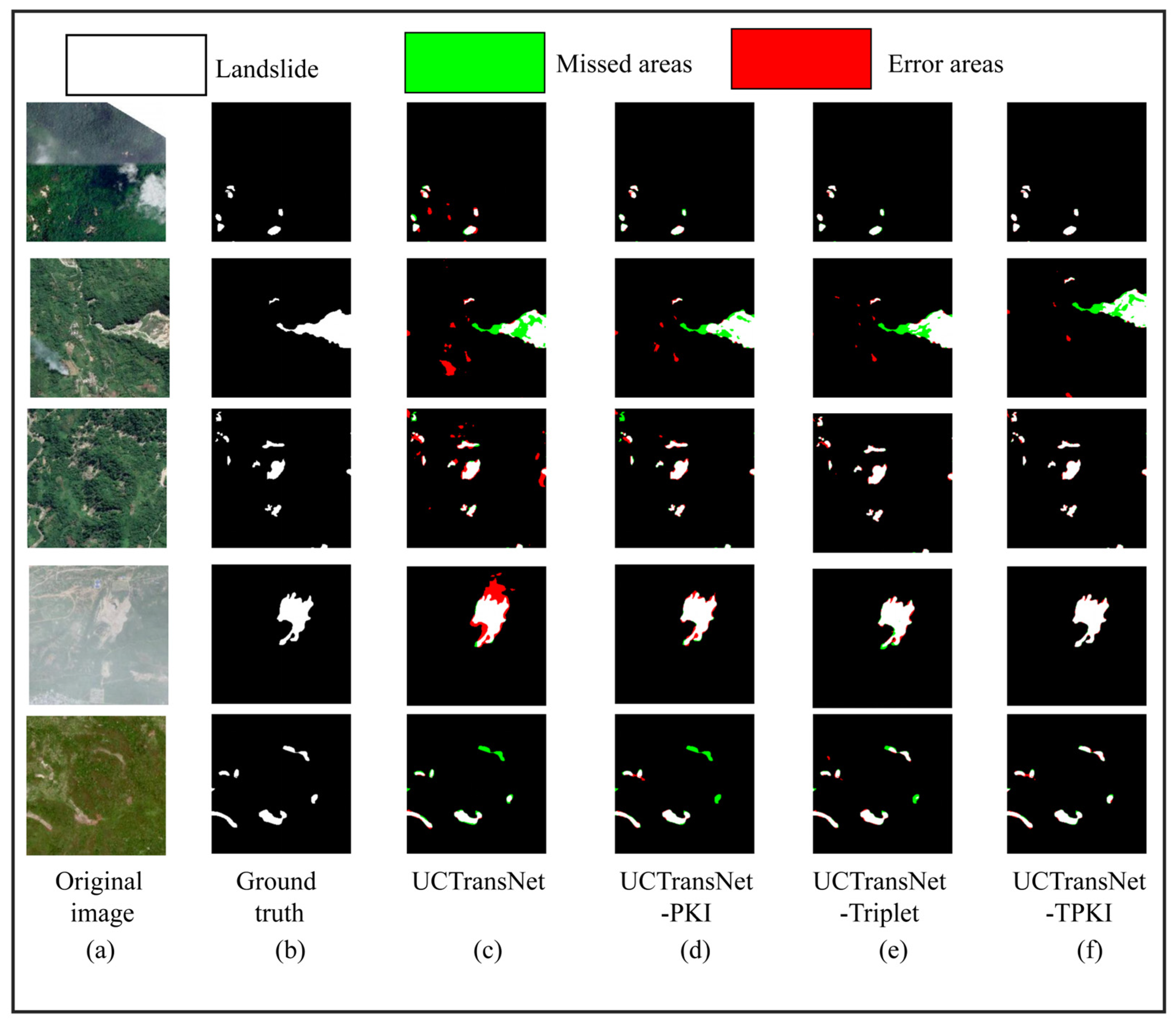
4.1.2. Ablation Study on Mengdong Dataset
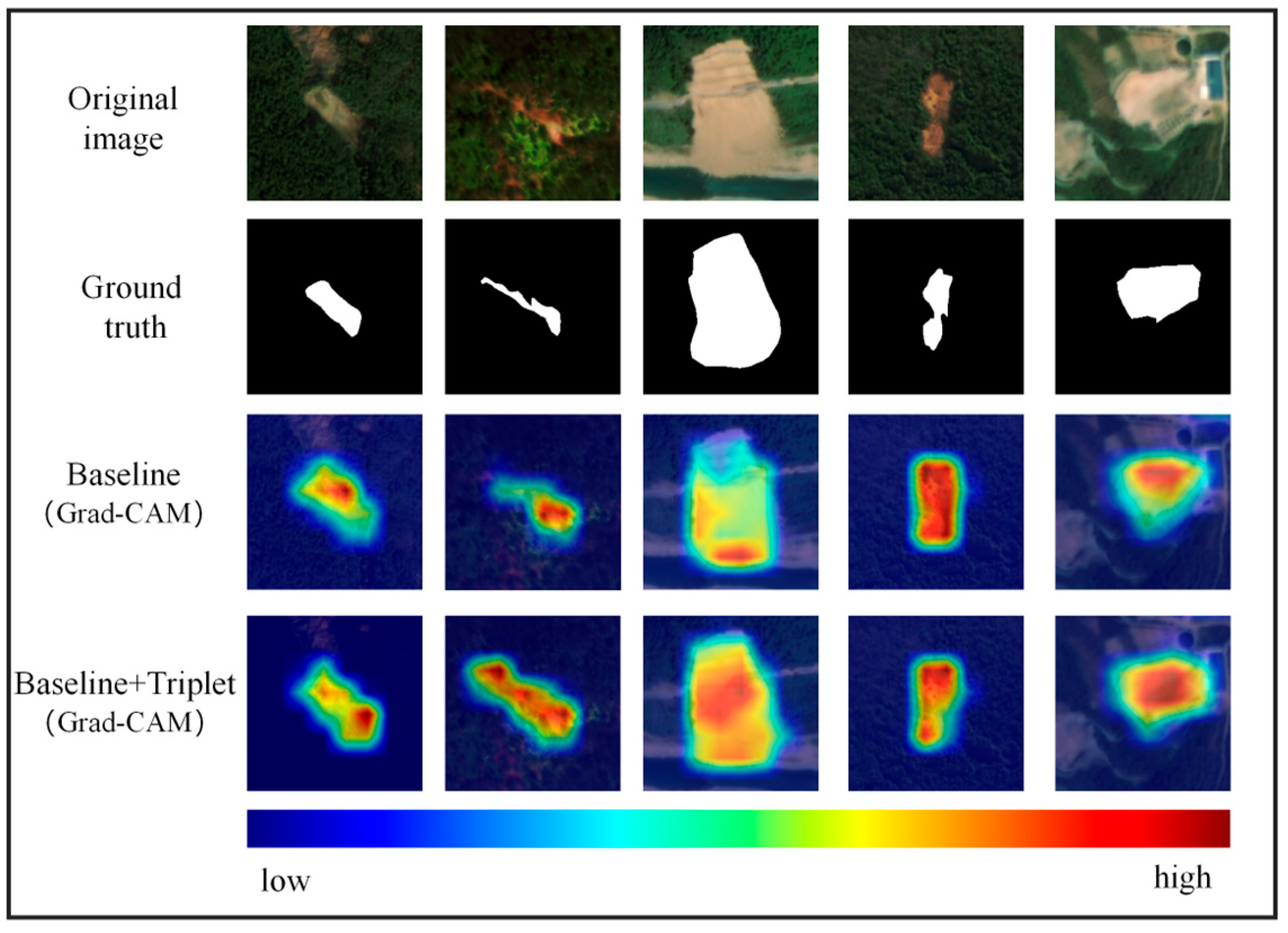
4.1.3. Visual Analysis of Feature Attention
4.2. Comparative Study
- (1)
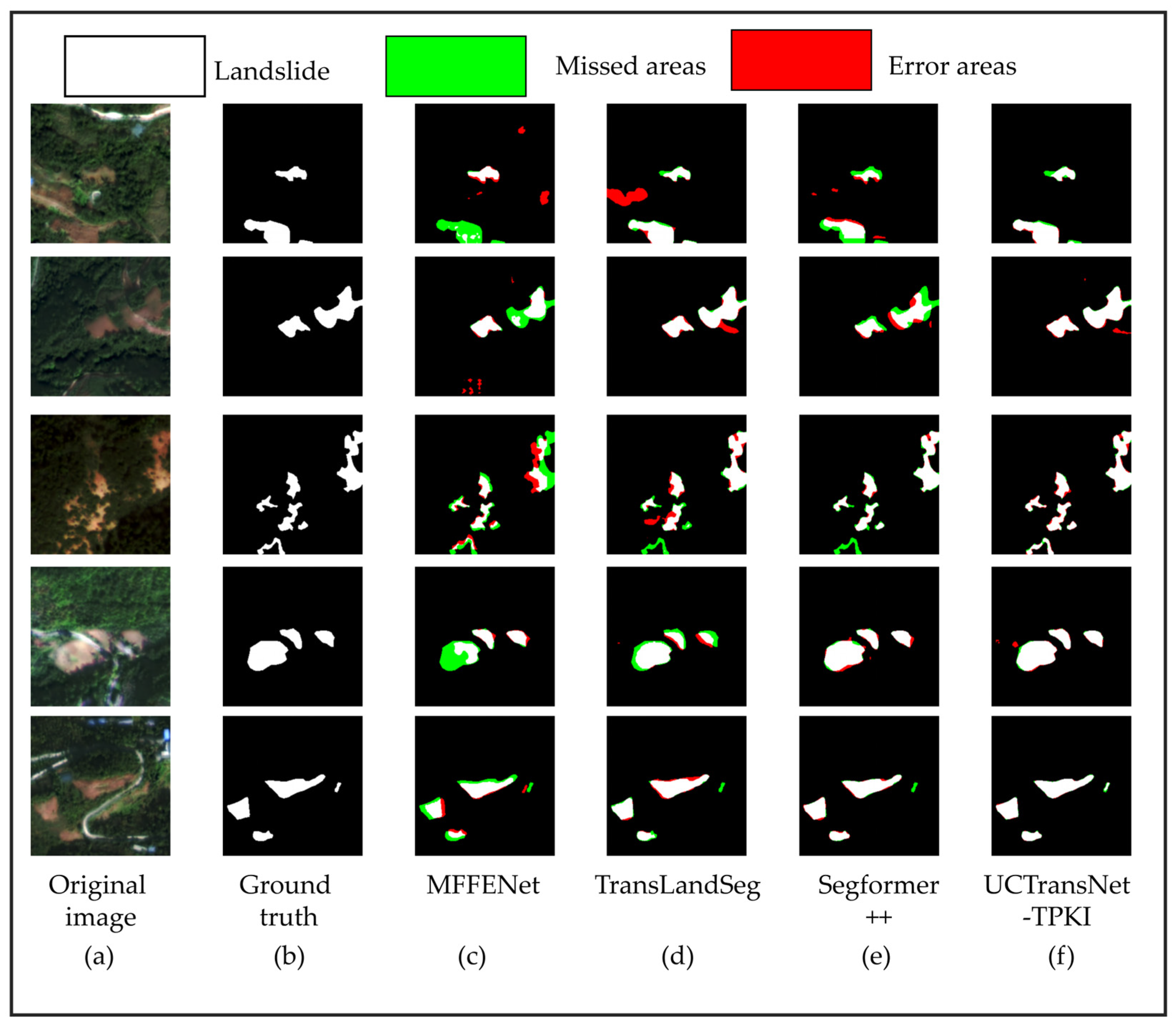
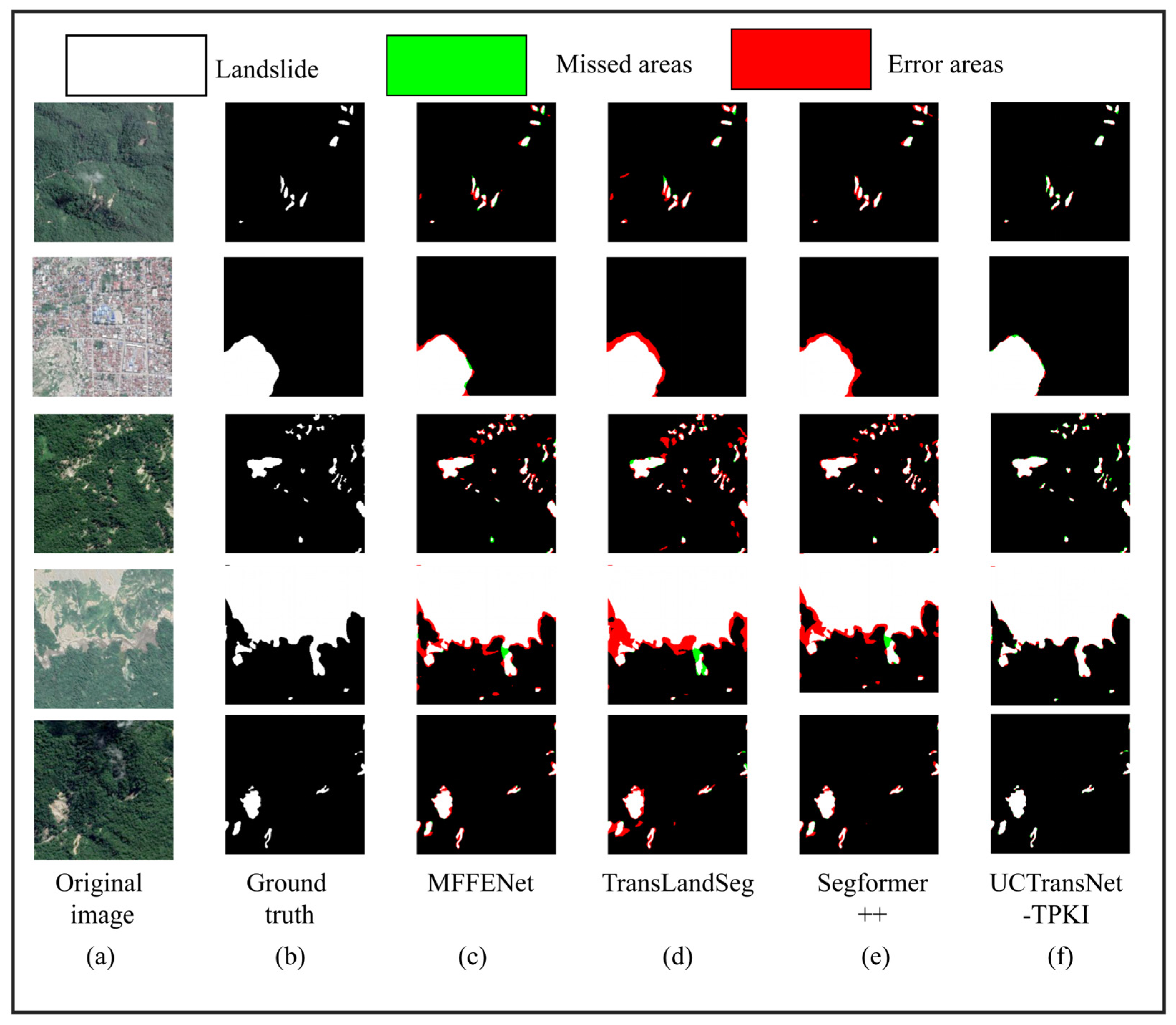
- MFFENet: The Multi-scale Feature Fusion Encoder–Decoder Network (MFFENet) integrates an Adaptive Triangle Fork (ATF) module to selectively combine features from multiple scales, along with a dense top-down feature pyramid structure. This methodology improves the network’s capacity to capture intricate local characteristics and overarching context, tackling issues such as significant intra-class variation and substantial scale discrepancies in remote sensing picture segmentation.
- (2)
- TransLandSeg: TransLandSeg is a transfer learning–based landslide segmentation framework built on a vision foundation model. It introduces an Adaptive Transfer Learning module to adapt the general segmentation capability of SAM to landslide scenes by training only a small fraction of parameters, enabling efficient knowledge transfer and competitive segmentation performance.
- (3)
- Segformer++: Segformer++ is an efficient transformer-based segmentation architecture that extends Segformer by introducing token-merging strategies to reduce computational complexity. Adaptively merging similar tokens within the hierarchical encoder improves efficiency for high-resolution semantic segmentation while largely preserving global contextual representation.
4.2.1. Comparative Study on Wushan Dataset
4.2.2. Comparative Study on Mengdong Dataset
4.3. Model Efficiency and Robustness Analysis
4.3.1. Computational Efficiency and Complexity
4.3.2. Statistical Significance and Robustness
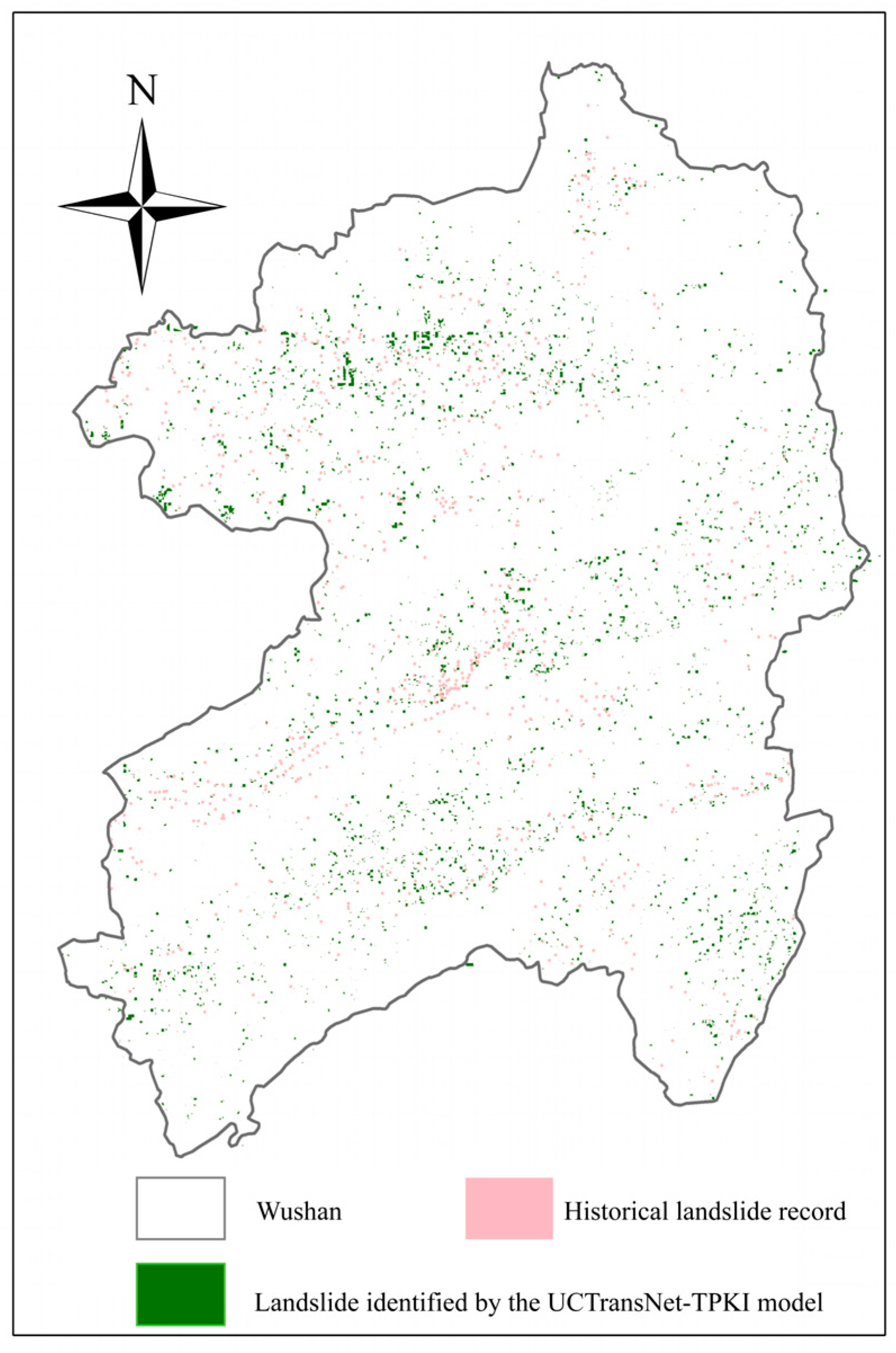
4.4. Extraction Results in Wushan County
5. Discussion
6. Conclusions
- (1)
- The UCTransNet-TPKI model, through its module integration, successfully enhances landslide recognition capabilities. The PKI module effectively captures the morphological features of different-sized landslides via parallel multi-scale convolutions, addressing the issue of scale variation. The Triplet Attention method enhances the model’s detection of weak edges and greatly increases its capacity to differentiate landslides from spectrally identical backdrops (such as barren land) because of its distinctive cross-dimensional interaction design.
- (2)
- On the Wushan County dataset, which is dominated by small-scale landslides, UCTransNet-TPKI outperformed the baseline UCTransNet model and other module combinations across all key evaluation metrics. The ablation studies and visualization results strongly demonstrate that the synergy between the PKI module and Triplet Attention is the key to this performance breakthrough.
- (3)
- The model also demonstrated consistent performance advantages on the Mengdong dataset, which has significant differences in its geographical environment and disaster causality. This indicates that the model is not limited to a specific region and possesses strong robustness and potential for broader application.
Author Contributions
Funding
Data Availability Statement
Acknowledgments
Conflicts of Interest
Appendix A

References
- Shrestha, M.; Sharma, S.; Pradhan Shrestha, R. Landslides in the Himalayas: A Comprehensive Review of Hazards, Impacts, and Adaptive Strategies. Rural Reg. Dev. 2025, 3, 10002. [Google Scholar] [CrossRef]
- Alcántara-Ayala, I. Landslides in a Changing World. Landslides 2025, 22, 2851–2865. [Google Scholar] [CrossRef]
- Alimohammadlou, Y.; Najafi, A.; Yalcin, A. Landslide Process and Impacts: A Proposed Classification Method. Catena 2013, 104, 219–232. [Google Scholar] [CrossRef]
- Geertsema, M.; Highland, L.; Vaugeouis, L. Environmental Impact of Landslides. In Landslides—Disaster Risk Reduction; Sassa, K., Canuti, P., Eds.; Springer: Berlin/Heidelberg, Germany, 2009; pp. 589–607. ISBN 978-3-540-69970-5. [Google Scholar]
- Kumari, S.; Agarwal, S.; Agrawal, N.K.; Agarwal, A.; Garg, M.C. A Comprehensive Review of Remote Sensing Technologies for Improved Geological Disaster Management. Geol. J. 2024, 60, 223–235. [Google Scholar] [CrossRef]
- Ma, Z.; Mei, G.; Piccialli, F. Machine Learning for Landslides Prevention: A Survey. Neural Comput. Appl. 2021, 33, 10881–10907. [Google Scholar] [CrossRef]
- He, H.; Wang, W.; Wang, Z.; Li, S.; Chen, J. Enhancing Seismic Landslide Susceptibility Analysis for Sustainable Disaster Risk Management through Machine Learning. Sustainability 2024, 16, 3828. [Google Scholar] [CrossRef]
- Guzzetti, F.; Mondini, A.C.; Cardinali, M.; Fiorucci, F.; Santangelo, M.; Chang, K.-T. Landslide Inventory Maps: New Tools for an Old Problem. Earth-Sci. Rev. 2012, 112, 42–66. [Google Scholar] [CrossRef]
- Fan, X.; Yunus, A.P.; Scaringi, G.; Catani, F.; Siva Subramanian, S.; Xu, Q.; Huang, R. Rapidly Evolving Controls of Landslides After a Strong Earthquake and Implications for Hazard Assessments. Geophys. Res. Lett. 2021, 48, e2020GL090509. [Google Scholar] [CrossRef]
- Dell’Acqua, F.; Gamba, P. Remote Sensing and Earthquake Damage Assessment: Experiences, Limits, and Perspectives. Proc. IEEE 2012, 100, 2876–2890. [Google Scholar] [CrossRef]
- Prakash, N.; Manconi, A.; Loew, S. A New Strategy to Map Landslides with a Generalized Convolutional Neural Network. Sci. Rep. 2021, 11, 9722. [Google Scholar] [CrossRef]
- Liu, R.; Li, L.; Pirasteh, S.; Lai, Z.; Yang, X.; Shahabi, H. The Performance Quality of LR, SVM, and RF for Earthquake-Induced Landslides Susceptibility Mapping Incorporating Remote Sensing Imagery. Arab. J. Geosci. 2021, 14, 259. [Google Scholar] [CrossRef]
- Guo, X.; Fu, B.; Du, J.; Shi, P.; Li, J.; Li, Z.; Du, J.; Chen, Q.; Fu, H. Monitoring and Assessment for the Susceptibility of Landslide Changes After the 2017 Ms 7.0 Jiuzhaigou Earthquake Using the Remote Sensing Technology. Front. Earth Sci. 2021, 9, 633117. [Google Scholar] [CrossRef]
- Casagli, N.; Intrieri, E.; Tofani, V.; Gigli, G.; Raspini, F. Landslide Detection, Monitoring and Prediction with Remote-Sensing Techniques. Nat. Rev. Earth Environ. 2023, 4, 51–64. [Google Scholar] [CrossRef]
- Achariyaviriya, W.; Kondo, T.; Karnjana, J.; Nishio, T. Landslide Semantic Segmentation Using Satellite Imagery. In Proceedings of the 2022 19th International Conference on Electrical Engineering/Electronics, Computer, Telecommunications and Information Technology (ECTI-CON), Prachuap Khiri Khan, Thailand, 24–27 May 2022; pp. 1–4. [Google Scholar]
- Carle, E.; Sirguey, P.; Cox, S.C. Measuring Landslide-Driven Ground Displacements with High-Resolution Surface Models and Optical Flow. Comput. Geosci. 2023, 178, 105378. [Google Scholar] [CrossRef]
- Li, Z.; Guo, Y. Semantic Segmentation of Landslide Images in Nyingchi Region Based on PSPNet Network. In Proceedings of the 2020 7th International Conference on Information Science and Control Engineering (ICISCE), Changsha, China, 18–20 December 2020; pp. 1269–1273. [Google Scholar]
- Chen, D.; Kang, J.; Wang, L.; Yu, Y.; Zhou, W.; Guan, H.; Karim, M. SACNet: A Novel Self-Supervised Learning Method for Shadow Detection from High-Resolution Remote Sensing Images. J. Geovisualization Spat. Anal. 2025, 9, 14. [Google Scholar] [CrossRef]
- Fang, Z.; Wang, Y.; Peng, L.; Hong, H. Integration of Convolutional Neural Network and Conventional Machine Learning Classifiers for Landslide Susceptibility Mapping. Comput. Geosci. 2020, 139, 104470. [Google Scholar] [CrossRef]
- Huang, F.; Cao, Z.; Guo, J.; Jiang, S.-H.; Li, S.; Guo, Z. Comparisons of Heuristic, General Statistical and Machine Learning Models for Landslide Susceptibility Prediction and Mapping. Catena 2020, 191, 104580. [Google Scholar] [CrossRef]
- Tehrani, F.S.; Calvello, M.; Liu, Z.; Zhang, L.; Lacasse, S. Machine Learning and Landslide Studies: Recent Advances and Applications. Nat. Hazards 2022, 114, 1197–1245. [Google Scholar] [CrossRef]
- Zhou, C.; Yin, K.; Cao, Y.; Ahmed, B.; Li, Y.; Catani, F.; Pourghasemi, H.R. Landslide Susceptibility Modeling Applying Machine Learning Methods: A Case Study from Longju in the Three Gorges Reservoir Area, China. Comput. Geosci. 2018, 112, 23–37. [Google Scholar] [CrossRef]
- Holloway, J.; Mengersen, K. Statistical Machine Learning Methods and Remote Sensing for Sustainable Development Goals: A Review. Remote Sens. 2018, 10, 1365. [Google Scholar] [CrossRef]
- Sameen, M.I.; Pradhan, B.; Lee, S. Application of Convolutional Neural Networks Featuring Bayesian Optimization for Landslide Susceptibility Assessment. Catena 2020, 186, 104249. [Google Scholar] [CrossRef]
- Guarnieri, A.; Masiero, A.; Vettore, A.; Pirotti, F. Evaluation of the Dynamic Processes of a Landslide with Laser Scanners and Bayesian Methods. Geomat. Nat. Hazards Risk 2015, 6, 614–634. [Google Scholar] [CrossRef][Green Version]
- Nhu, V.-H.; Mohammadi, A.; Shahabi, H.; Ahmad, B.B.; Al-Ansari, N.; Shirzadi, A.; Geertsema, M.; Kress, V.R.; Karimzadeh, S.; Valizadeh Kamran, K.; et al. Landslide Detection and Susceptibility Modeling on Cameron Highlands (Malaysia): A Comparison between Random Forest, Logistic Regression and Logistic Model Tree Algorithms. Forests 2020, 11, 830. [Google Scholar] [CrossRef]
- Dou, J.; Yunus, A.P.; Bui, D.T.; Merghadi, A.; Sahana, M.; Zhu, Z.; Chen, C.-W.; Han, Z.; Pham, B.T. Improved Landslide Assessment Using Support Vector Machine with Bagging, Boosting, and Stacking Ensemble Machine Learning Framework in a Mountainous Watershed, Japan. Landslides 2020, 17, 641–658. [Google Scholar] [CrossRef]
- Chen, F.; Yu, B.; Li, B. A Practical Trial of Landslide Detection from Single-Temporal Landsat8 Images Using Contour-Based Proposals and Random Forest: A Case Study of National Nepal. Landslides 2018, 15, 453–464. [Google Scholar] [CrossRef]
- Jiang, P.; Ma, Z.; Mei, G. Review Article: Deep Learning for Potential Landslide Identification: Data, Models, Applications, Challenges, and Opportunities. Nat. Hazards Earth Syst. Sci. 2026, 26(1), 487–529. [Google Scholar] [CrossRef]
- Yu, B.; Li, J.; Huang, X. STSNet: A Cross-Spatial Resolution Multi-Modal Remote Sensing Deep Fusion Network for High Resolution Land-Cover segmentation. Inf. Fusion 2025, 114, 102689. [Google Scholar] [CrossRef]
- Wang, J.; Sun, P.; Chen, L.; Yang, J.; Liu, Z.; Lian, H. Recent Advances of Deep Learning in Geological Hazard Forecasting. CMES—Comput. Model. Eng. Sci. 2023, 137, 1381–1418. [Google Scholar] [CrossRef]
- Ma, Z.; Mei, G. Deep Learning for Geological Hazards Analysis: Data, Models, Applications, and Opportunities. Earth-Sci. Rev. 2021, 223, 103858. [Google Scholar] [CrossRef]
- Xu, G.; Wang, Y.; Wang, L.; Soares, L.P.; Grohmann, C.H. Feature-Based Constraint Deep CNN Method for Mapping Rainfall-Induced Landslides in Remote Regions with Mountainous Terrain: An Application to Brazil. IEEE J. Sel. Top. Appl. Earth Obs. Remote Sens. 2022, 15, 2644–2659. [Google Scholar] [CrossRef]
- Wei, R.; Ye, C.; Sui, T.; Zhang, H.; Ge, Y.; Li, Y. A Feature Enhancement Framework for Landslide Detection. Int. J. Appl. Earth Obs. Geoinf. 2023, 124, 103521. [Google Scholar] [CrossRef]
- Wang, Q.; Sun, L.; Chen, Y. The Influence and Improvement of a Deep Learning-Based Uncertainty Model Integrating Multi-Scale Information in Landslide Detection. In Proceedings of the IGARSS 2024—2024 IEEE International Geoscience and Remote Sensing Symposium, Athens, Greece, 7–12 July 2024; pp. 10413–10416. [Google Scholar]
- Yu, B.; Zhu, M.; Chen, F.; Wang, N.; Zhao, H.; Wang, L. Multi-Scale Differential Network for Landslide Extraction from Remote Sensing Images with Different Scenarios. Int. J. Digit. Earth 2024, 17, 2441920. [Google Scholar] [CrossRef]
- Liu, X.; Xu, L.; Zhang, J. Landslide Detection with Mask R-CNN Using Complex Background Enhancement Based on Multi-Scale Samples. Geomat. Nat. Hazards Risk 2024, 15, 2300823. [Google Scholar] [CrossRef]
- Guo, S.; Li, B.; Wu, X.; Niu, R.; Wu, W. Landslide Detection Based on Differential Fusion of Multi-Level Features From Optical Remote Sensing Images and Topographical Data. Trans. GIS 2025, 29, e70046. [Google Scholar] [CrossRef]
- Zhong, C.; Liu, Y.; Gao, P.; Chen, W.; Li, H.; Hou, Y.; Nuremanguli, T.; Ma, H. Landslide Mapping with Remote Sensing: Challenges and Opportunities. Int. J. Remote Sens. 2019, 41, 1555–1581. [Google Scholar] [CrossRef]
- Martha, T.R.; Kerle, N.; Jetten, V.; van Westen, C.J.; Kumar, K.V. Characterising Spectral, Spatial and Morphometric Properties of Landslides for Semi-Automatic Detection Using Object-Oriented Methods. Geomorphology 2010, 116, 24–36. [Google Scholar] [CrossRef]
- Cai, X.; Lai, Q.; Wang, Y.; Wang, W.; Sun, Z.; Yao, Y. Poly Kernel Inception Network for Remote Sensing Detection. In Proceedings of the 2024 IEEE/CVF Conference on Computer Vision and Pattern Recognition (CVPR), Seattle, WA, USA, 16–22 June 2024; pp. 27706–27716. [Google Scholar]
- Mei, X.; Pan, E.; Ma, Y.; Dai, X.; Huang, J.; Fan, F.; Du, Q.; Zheng, H.; Ma, J. Spectral-Spatial Attention Networks for Hyperspectral Image Classification. Remote Sens. 2019, 11, 963. [Google Scholar] [CrossRef]
- Wang, H.; Cao, P.; Wang, J.; Zaiane, O.R. UCTransNet: Rethinking the Skip Connections in U-Net from a Channel-Wise Perspective with Transformer. In Proceedings of the AAAI Conference on Artificial Intelligence; PKP PS: Burnaby, BC, Canada, 2022; Volume 36, pp. 2441–2449. [Google Scholar] [CrossRef]
- Misra, D.; Nalamada, T.; Arasanipalai, A.U.; Hou, Q. Rotate to Attend: Convolutional Triplet Attention Module. In Proceedings of the 2021 IEEE Winter Conference on Applications of Computer Vision (WACV), Waikoloa, HI, USA, 3–8 January 2021; pp. 3139–3148. [Google Scholar]
- Wen, H.; Huang, J.; Qian, L.; Li, Z.; Zhang, Y.; Zhang, J. The Spatial-Temporal Evolution Patterns of Landslide-Oriented Resilience in Mountainous City: A Case Study of Chongqing, China. J. Environ. Manag. 2024, 370, 122963. [Google Scholar] [CrossRef]
- Guo, Y.; Song, W. Spatial Distribution and Simulation of Cropland Abandonment in Wushan County, Chongqing, China. Sustainability 2019, 11, 1367. [Google Scholar] [CrossRef]
- Liao, M.; Wen, H.; Yang, L. Identifying the Essential Conditioning Factors of Landslide Susceptibility Models under Different Grid Resolutions Using Hybrid Machine Learning: A Case of Wushan and Wuxi Counties, China. Catena 2022, 217, 106428. [Google Scholar] [CrossRef]
- Xu, Y.; Ouyang, C.; Xu, Q.; Wang, D.; Zhao, B.; Luo, Y. CAS Landslide Dataset: A Large-Scale and Multisensor Dataset for Deep Learning-Based Landslide Detection. Sci. Data 2024, 11, 12. [Google Scholar] [CrossRef] [PubMed]
- Li, J.; Li, Q.; Lu, J.; Zheng, K.; Wei, L.; Xiang, Q. A Transfer Learning Remote Sensing Landslide Image Segmentation Method Based on Nonlinear Modeling and Large Kernel Attention. Appl. Sci. 2025, 15, 3855. [Google Scholar] [CrossRef]
- Selvaraju, R.R.; Cogswell, M.; Das, A.; Vedantam, R.; Parikh, D.; Batra, D. Grad-CAM: Visual Explanations from Deep Networks via Gradient-Based Localization. In Proceedings of the 2017 IEEE International Conference on Computer Vision (ICCV), Venice, Italy, 22–29 October 2017; pp. 618–626. [Google Scholar]
- Xu, Q.; Ouyang, C.; Jiang, T.; Yuan, X.; Fan, X.; Cheng, D. MFFENet and ADANet: A Robust Deep Transfer Learning Method and Its Application in High Precision and Fast Cross-Scene Recognition of Earthquake-Induced Landslides. Landslides 2022, 19, 1617–1647. [Google Scholar] [CrossRef]
- Hou, C.; Yu, J.; Ge, D.; Yang, L.; Xi, L.; Pang, Y.; Wen, Y. A Transfer Learning Approach for Landslide Semantic Segmentation Based on Visual Foundation Model. IEEE J. Sel. Top. Appl. Earth Obs. Remote Sens. 2025, 18, 11561–11572. [Google Scholar] [CrossRef]
- Kienzle, D.; Kantonis, M.; Schön, R.; Lienhart, R. Segformer++: Efficient Token-Merging Strategies for High-Resolution Semantic Segmentation. In Proceedings of the 2024 IEEE 7th International Conference on Multimedia Information Processing and Retrieval (MIPR), San Jose, CA, USA, 7–9 August 2024; pp. 75–81. [Google Scholar]
- Liu, Q.; Wang, T.; Zheng, Z.; Wang, B. A Method for Identifying Gully-Type Debris Flows Based on Adaptive Multi-Scale Feature Extraction. Geomat. Nat. Hazards Risk 2025, 16, 2502593. [Google Scholar] [CrossRef]
- Liu, Z.; Cui, S.; Yan, Q. Building Extraction from High Resolution Satellite Imagery Based on Multi-Scale Image Segmentation and Model Matching. In Proceedings of the 2008 International Workshop on Earth Observation and Remote Sensing Applications, Beijing, China, 30 June–2 July 2008; pp. 1–7. [Google Scholar]
- Mantovani, J.R.; Bueno, G.T.; Alcântara, E.; Park, E.; Cunha, A.P.; Londe, L.; Massi, K.; Marengo, J.A. Novel Landslide Susceptibility Mapping Based on Multi-Criteria Decision-Making in Ouro Preto, Brazil. J. Geovisualization Spat. Anal. 2023, 7, 7. [Google Scholar] [CrossRef]
- Cai, J.; Liu, G.; Jia, H.; Zhang, B.; Wu, R.; Fu, Y.; Xiang, W.; Mao, W.; Wang, X.; Zhang, R. A New Algorithm for Landslide Dynamic Monitoring with High Temporal Resolution by Kalman Filter Integration of Multiplatform Time-Series InSAR Processing Kalman. Int. J. Appl. Earth Obs. Geoinf. 2022, 110, 102812. [Google Scholar] [CrossRef]





| Dataset Name | Quantity | Sensor | Resolution |
|---|---|---|---|
| Wushan Dataset | 1000 | GF-2 | 0.8 m |
| Mengdong Dataset | 1155 | SuperView-1 | 0.5 m |
| Hyperparameter | Value |
|---|---|
| Batch size | 6 |
| Optimizer | Adam |
| Adam β1, β2 | 0.9, 0.999 |
| Initial Learning Rate | 1 × 10⁻⁴ |
| Epoch | 500 |
| Learning Rate Scheduling Strategy | ReduceLROnPlateau |
| Loss Function Specifics | Weighted Dice-BCE Loss |
| Dataset | Model | Precision | F1 | IoU | Acc |
|---|---|---|---|---|---|
| Wushan Dataset | UCTransNet | 0.8850 | 0.8888 | 0.8151 | 0.9790 |
| UCTransNet-Triplet | 0.8925 | 0.8919 | 0.8180 | 0.9790 | |
| UCTransNet-PKI | 0.8930 | 0.8925 | 0.8185 | 0.9785 | |
| UCTransNet-TPKI | 0.8936 | 0.9008 | 0.8252 | 0.9806 |
| Dataset | Model | Precision | F1 | IoU | Acc |
|---|---|---|---|---|---|
| Mengdong Dataset | UCTransNet | 0.8825 | 0.9103 | 0.8365 | 0.9631 |
| UCTransNet-Triplet | 0.8912 | 0.9150 | 0.8437 | 0.9658 | |
| UCTransNet-PKI | 0.8950 | 0.9180 | 0.8455 | 0.9765 | |
| UCTransNet-TPKI | 0.9015 | 0.9230 | 0.8560 | 0.9780 |
| Dataset | Model | Precision | F1 | IoU | Acc |
|---|---|---|---|---|---|
| Wushan Dataset | MFFENet | 0.8992 | 0.8758 | 0.7790 | 0.9724 |
| TransLandSeg | 0.8985 | 0.8778 | 0.7823 | 0.9725 | |
| Segformer++ | 0.9056 | 0.8915 | 0.8042 | 0.9387 | |
| UCTransNet-TPKI | 0.8936 | 0.9008 | 0.8252 | 0.9806 |
| Dataset | Model | Precision | F1 | IoU | Acc |
|---|---|---|---|---|---|
| Mengdong Dataset | MFFENet | 0.8945 | 0.9149 | 0.8434 | 0.9700 |
| TransLandSeg | 0.9104 | 0.8943 | 0.8088 | 0.9762 | |
| Segformer++ | 0.9137 | 0.9019 | 0.8214 | 0.9468 | |
| UCTransNet-TPKI | 0.9015 | 0.9230 | 0.8560 | 0.9780 |
| Model | Parameters | FLOPs | Inference Time |
|---|---|---|---|
| UCTransNet | 66.24 M | 43.058 G | 23.68 ms |
| UCTransNet-Triplet | 16.83 M | 40.82 G | 16.05 ms |
| UCTransNet-TPKI | 19.56 M | 50.90 G | 16.79 ms |
| Model | IoU (Mean ± Std × 10−2) | F1-Score (Mean ± Std × 10−2) |
|---|---|---|
| UCTransNet | 0.8886 ± 0.11 | 0.8150± 0.09 |
| UCTransNet-TPKI | 0.9007 ± 0.21 | 0.8251 ± 0.23 |
Disclaimer/Publisher’s Note: The statements, opinions and data contained in all publications are solely those of the individual author(s) and contributor(s) and not of MDPI and/or the editor(s). MDPI and/or the editor(s) disclaim responsibility for any injury to people or property resulting from any ideas, methods, instructions or products referred to in the content. |
© 2026 by the authors. Licensee MDPI, Basel, Switzerland. This article is an open access article distributed under the terms and conditions of the Creative Commons Attribution (CC BY) license.
Share and Cite
Wang, M.; Ding, W.; Liu, M.; Liu, Z.; Liu, X.; Wen, Y.; Li, H. Improved UCTransNet by Integrating Pyramid Kernel Interaction with Triplet Attention for Identifying Multi-Scale Landslides from GF-2 Imagery. Remote Sens. 2026, 18, 492. https://doi.org/10.3390/rs18030492
Wang M, Ding W, Liu M, Liu Z, Liu X, Wen Y, Li H. Improved UCTransNet by Integrating Pyramid Kernel Interaction with Triplet Attention for Identifying Multi-Scale Landslides from GF-2 Imagery. Remote Sensing. 2026; 18(3):492. https://doi.org/10.3390/rs18030492
Chicago/Turabian StyleWang, Miao, Weicui Ding, Meiling Liu, Zujian Liu, Xiangnan Liu, Yanan Wen, and Hao Li. 2026. "Improved UCTransNet by Integrating Pyramid Kernel Interaction with Triplet Attention for Identifying Multi-Scale Landslides from GF-2 Imagery" Remote Sensing 18, no. 3: 492. https://doi.org/10.3390/rs18030492
APA StyleWang, M., Ding, W., Liu, M., Liu, Z., Liu, X., Wen, Y., & Li, H. (2026). Improved UCTransNet by Integrating Pyramid Kernel Interaction with Triplet Attention for Identifying Multi-Scale Landslides from GF-2 Imagery. Remote Sensing, 18(3), 492. https://doi.org/10.3390/rs18030492