Dynamics of Forest Disturbance in the Canopy of Permanent Production Forests: A Multitemporal Analysis (2004–2025) Using Spectral Unmixing in the Southeastern Peruvian Amazon

 ,
, 
 ,
, 
Highlights
- Structural degradation in the understory surpassed permanent deforestation as the primary driver of forest disturbance in the Tahuamanu Province.
- Stratified statistical analysis revealed over 10,000 hectares of hidden forest degradation that medium-resolution optical classifications fail to detect.
- Relying exclusively on uncalibrated satellite maps underestimates actual biomass loss and conceals persistent degradation beneath a false cartographic stability.
- Territorial monitoring and sustainable management require the mandatory statistical correction of areas and the integration of active sensors (LiDAR) to accurately monitor forest ecosystem integrity.
Abstract
1. Introduction
2. Materials and Methods
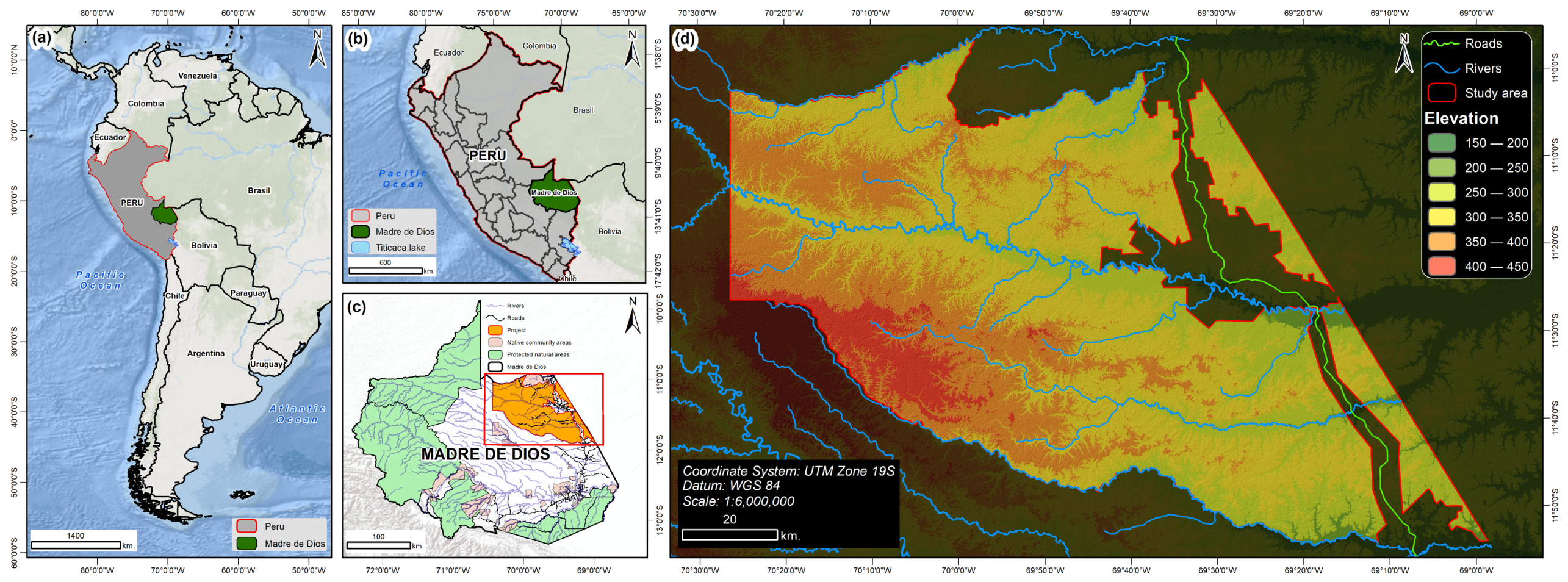
2.1. Study Area
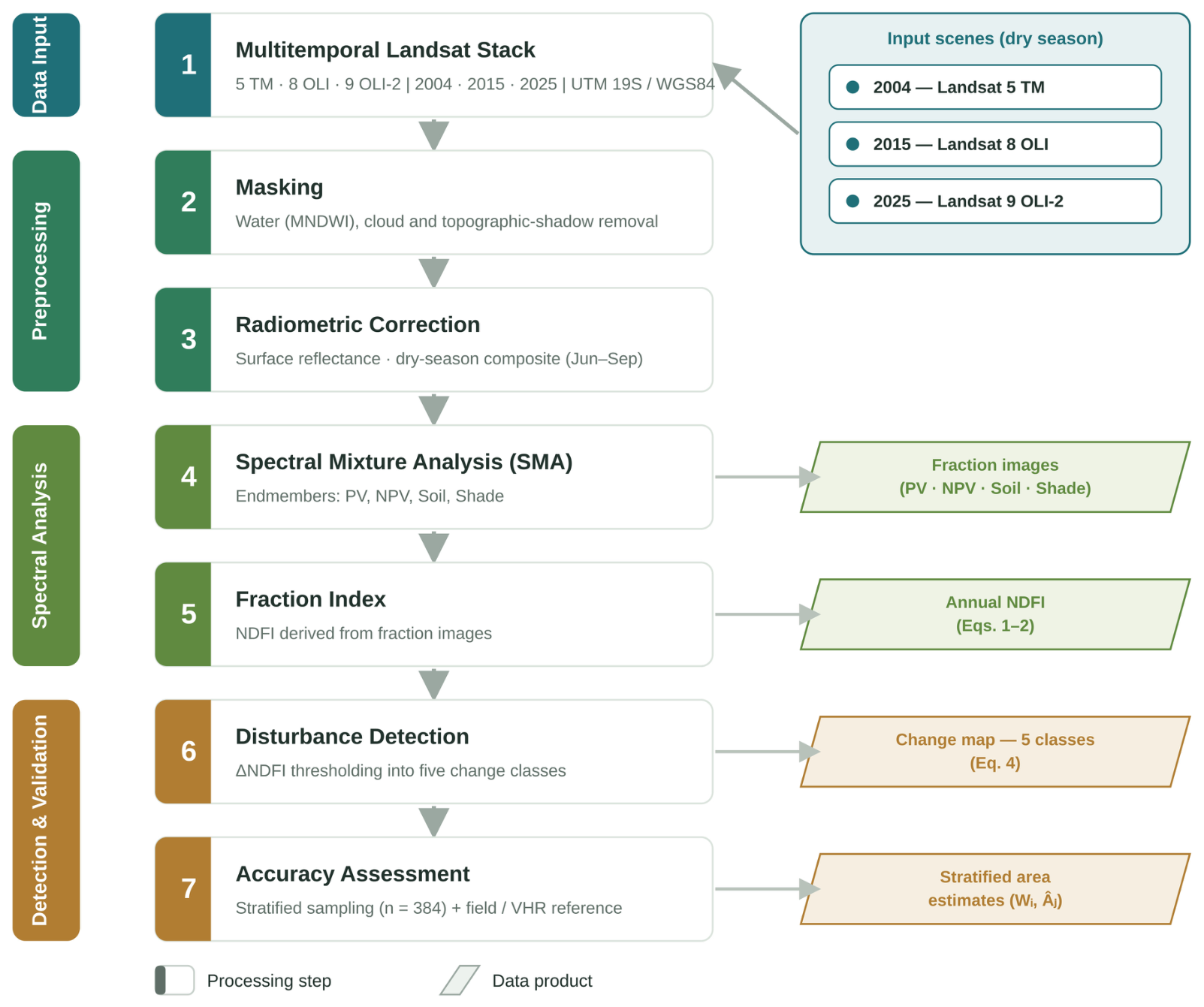
2.2. Method
2.2.1. Preprocessing and Spectral Mixture Analysis (SMA)
2.2.2. Classification of Forest Cover
2.2.3. Annual Deforestation and Degradation Rate
2.2.4. Detection of Disturbance Dynamics
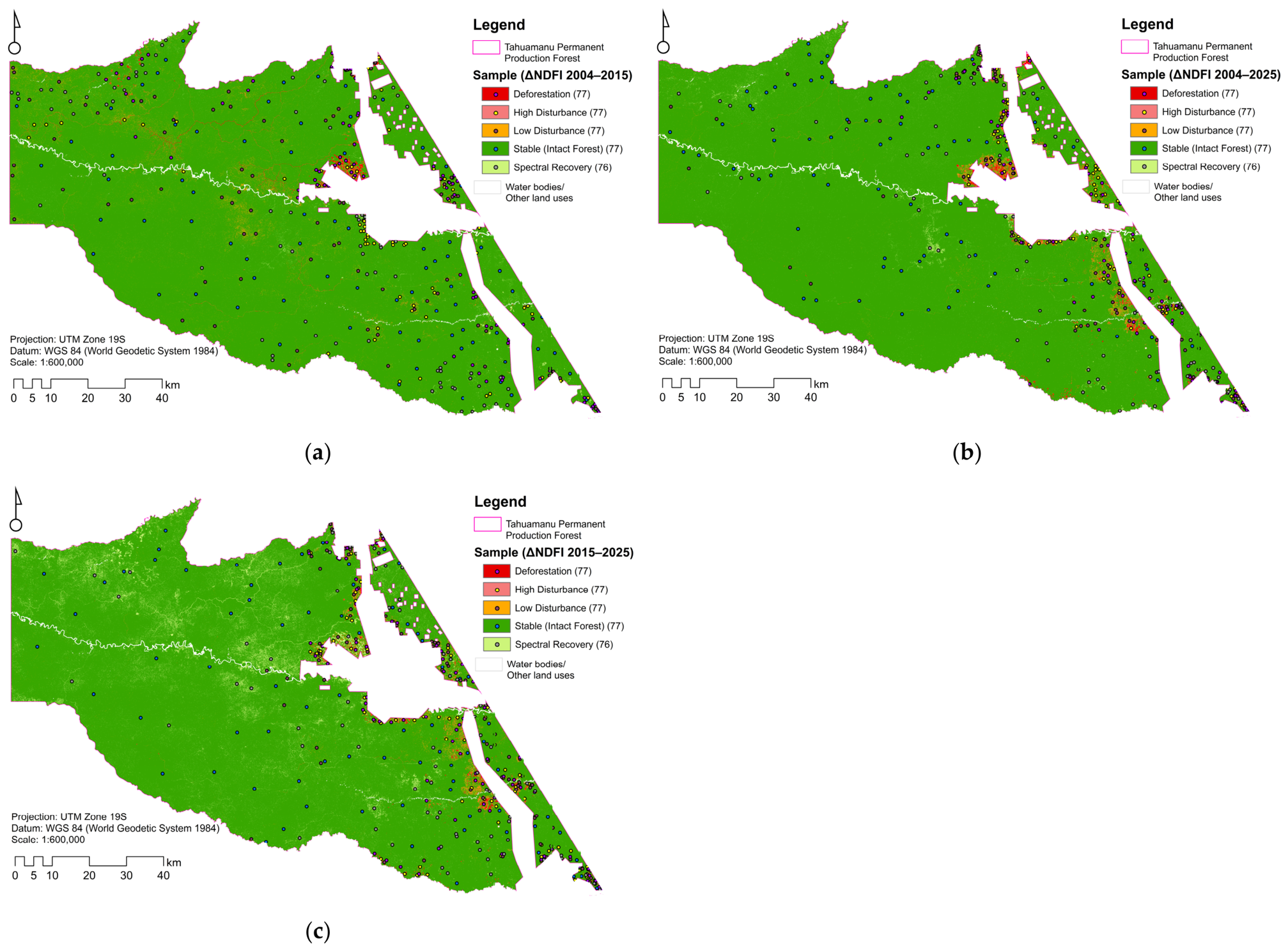
2.2.5. Sampling Design and Validation
3. Results
3.1. Validation
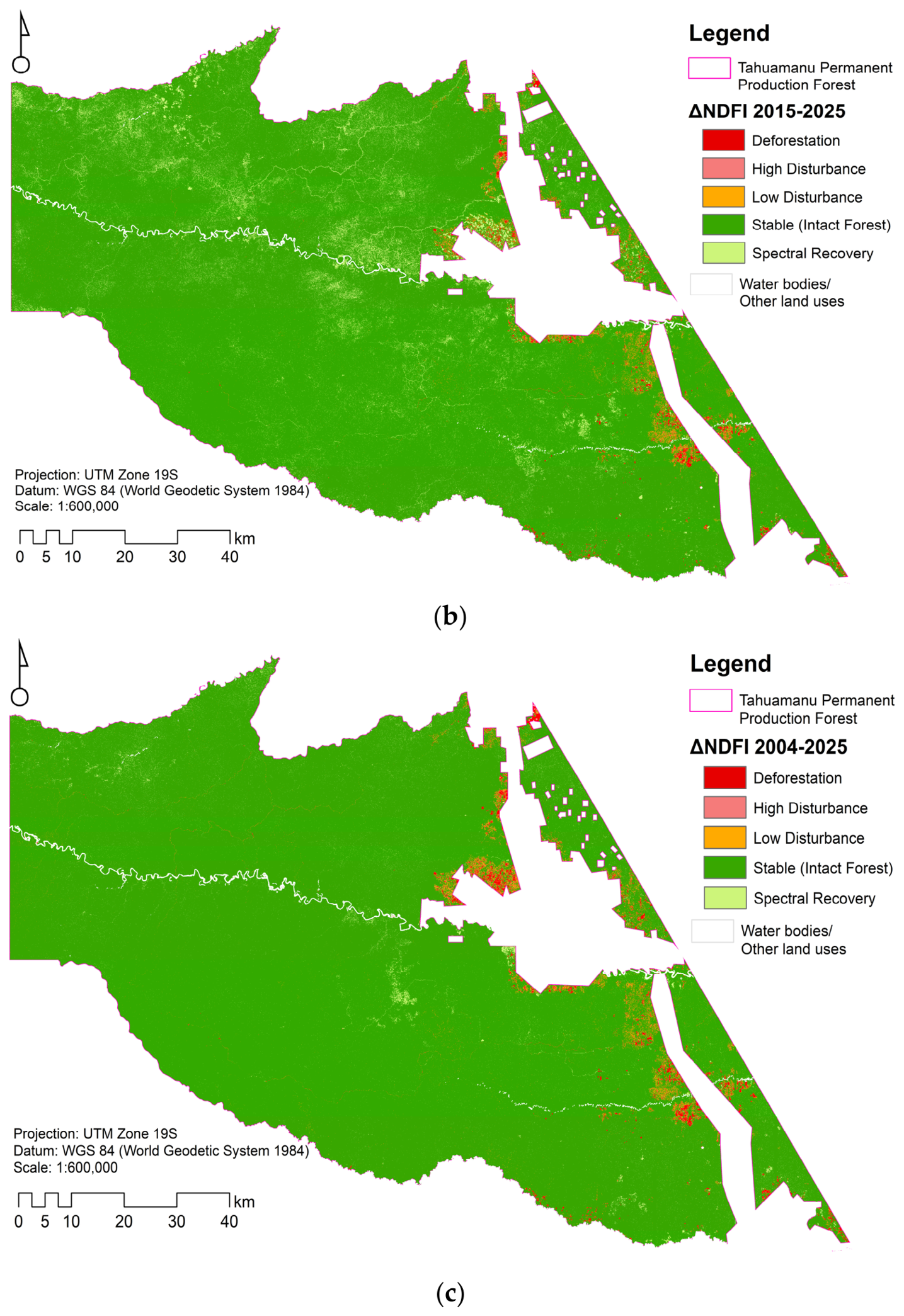
3.2. Classification of Forest Cover
3.3. Annual Rate of Deforestation and Forest Degradation
3.4. Disturbance Dynamics and Area Adjustment
4. Discussion
4.1. Spatial Patterns: Driving Forces of Alteration in Tahuamanu
4.2. Temporal Acceleration and the Shift Toward Degradation
4.3. Spectral Limitations and Understory Disturbance Detection
4.4. Adjusted Areas, Subtle Degradation, and Future Perspectives
4.5. Comparison with Other Amazonian Forest Studies
4.6. Sources of Uncertainty and Data Limitations
4.7. Selection of the NDFI Among Current Forest Disturbance-Monitoring Methods
5. Conclusions
Supplementary Materials
Author Contributions
Funding
Data Availability Statement
Acknowledgments
Conflicts of Interest
References
- Tarazona, Y.; Miyasiro-López, M. Monitoring tropical forest degradation using remote sensing. Challenges and opportunities in the Madre de Dios region, Peru. Remote Sens. Appl. Soc. Environ. 2020, 19, 100337. [Google Scholar] [CrossRef] [Scilit]
- Zhang, Y.; Woodcock, C.E.; Arévalo, P.; Olofsson, P.; Tang, X.; Stanimirova, R.; Bullock, E.; Tarrio, K.R.; Zhu, Z.; Friedl, M.A. A Global Analysis of the Spatial and Temporal Variability of Usable Landsat Observations at the Pixel Scale. Front. Remote Sens. 2022, 3, 894618. [Google Scholar] [CrossRef] [Scilit]
- Alarcon-Aguirre, G.; Canahuire, R.R.; Guevarra, F.M.G.; Rodriguez, L.; Gallegos, L.E.; Garate-Quispe, J. Dinámica de la pérdida de bosques en el sureste de la Amazonia peruana: Un estudio de caso en Madre de Dios. Ecosistemas 2021, 30, 2175. [Google Scholar] [CrossRef] [Scilit]
- Alarcon-Aguirre, G.; Mamani Mamani, M.; Canahuire-Robles, R.R.; Vasquez Zavaleta, T.; Peña Valdeiglesias, J.; Diaz Revoredo, J.; Rodríguez Achata, L.; Ramos Enciso, D.; Garate-Quispe, J. Forest Loss Related to Brazil Nut Production in Non-Timber Forest Product Concessions in a Micro-Watershed in the Peruvian Amazon. Remote Sens. 2023, 15, 5438. [Google Scholar] [CrossRef] [Scilit]
- Chávez, A.; Huamani, L.; Fernandez, R.; Bejar, N.; Valera, F.; Perz, S.; Brown, I.; Domínguez, S.; Pinedo, R.; Alarcón, G. Regional Deforestation Trends within Local Realities: Land-Cover Change in Southeastern Peru 1996–2011. Land 2013, 2, 131. [Google Scholar] [CrossRef] [Scilit]
- Perz, S.; Qiu, Y.; Xia, Y.; Southworth, J.; Sun, J.; Marsik, M.; Rocha, K.; Passos, V.; Rojas, D.; Alarcón, G.; et al. Trans-boundary infrastructure and land cover change: Highway paving and community-level deforestation in a tri-national frontier in the Amazon. Land Use Policy 2013, 34, 27–41. [Google Scholar] [CrossRef] [Scilit]
- Baraloto, C.; Alverga, P.; Quispe, S.B.; Barnes, G.; Chura, N.B.; da Silva, I.B.; Castro, W.; da Souza, H.; de Souza Moll, I.E.; Del Alcazar Chilo, J.; et al. Effects of road infrastructure on forest value across a tri-national Amazonian frontier. Biol. Conserv. 2015, 191, 674–681. [Google Scholar] [CrossRef] [Scilit]
- Souza, C.M.; Siqueira, J.V.; Sales, M.H.; Fonseca, A.V.; Ribeiro, J.G.; Numata, I. Ten-year Landsat classification of deforestation and forest degradation in the Brazilian Amazon. Remote Sens. 2013, 5, 5493. [Google Scholar] [CrossRef] [Scilit]
- Reygadas, Y.; Spera, S.; Galati, V.; Salisbury, D.S.; Silva, S.; Novoa, S. Mapping forest disturbances across the Southwestern Amazon: Tradeoffs between open-source, Landsat-based algorithms. Environ. Res. Commun. 2021, 3, 091001. [Google Scholar] [CrossRef] [Scilit]
- Bullock, E.L.; Woodcock, C.E.; Holden, C.E. Improved change monitoring using an ensemble of time series algorithms. Remote Sens. Environ. 2020, 238, 111165. [Google Scholar] [CrossRef] [Scilit]
- Bullock, E.L.; Woodcock, C.E.; Olofsson, P. Monitoring tropical forest degradation using spectral unmixing and Landsat time series analysis. Remote Sens. Environ. 2020, 238, 110968. [Google Scholar] [CrossRef] [Scilit]
- Souza, C.M.; Oliveira, L.A.; de Souza Filho, J.S.; Ferreira, B.G.; Fonseca, A.V.; Siqueira, J.V. Landsat sub-pixel land cover dynamics in the Brazilian Amazon. Front. For. Glob. Change 2023, 6, 1294552. [Google Scholar] [CrossRef] [Scilit]
- Matricardi, E.A.T.; Skole, D.L.; Costa, O.B.; Pedlowski, M.A.; Samek, J.H.; Miguel, E.P. Long-term forest degradation surpasses deforestation in the Brazilian Amazon. Science 2020, 369, 1378–1382. [Google Scholar] [CrossRef] [Scilit] [PubMed]
- Nguyen, H.; Behre, E.; Nguyen, H.K.L.; Pham, G.T.; Vu, B.T.; Egerer, M.; Bachofer, F. Forest dynamics mapping in central Vietnam from 1988 to 2022 using Landsat time-series data. Environ. Res. Lett. 2025, 20, 074048. [Google Scholar] [CrossRef] [Scilit]
- Reygadas, Y.; Spera, S.A.; Salisbury, D.S. Effects of deforestation and forest degradation on ecosystem service indicators across the Southwestern Amazon. Ecol. Indic. 2023, 147, 109996. [Google Scholar] [CrossRef] [Scilit]
- Shimabukuro, Y.E.; Arai, E.; Duarte, V.; Jorge, A.; Santos, E.G.d.; Gasparini, K.A.C.; Dutra, A.C. Monitoring deforestation and forest degradation using multi-temporal fraction images derived from Landsat sensor data in the Brazilian Amazon. Int. J. Remote Sens. 2019, 40, 5475–5496. [Google Scholar] [CrossRef] [Scilit]
- Wulder, M.A.; Roy, D.P.; Radeloff, V.C.; Loveland, T.R.; Anderson, M.C.; Johnson, D.M.; Healey, S.; Zhu, Z.; Scambos, T.A.; Pahlevan, N.; et al. Fifty years of Landsat science and impacts. Remote Sens. Environ. 2022, 280, 113195. [Google Scholar] [CrossRef] [Scilit]
- Asner, G.P.; David, E.K.; Aravindh, B.; Guayana, P.-A. Automated mapping of tropical deforestation and forest degradation: CLASlite. J. Appl. Remote Sens. 2009, 3, 033543. [Google Scholar] [CrossRef] [Scilit]
- Quintano, C.; Fernández-Manso, A.; Shimabukuro, Y.E.; Pereira, G. Spectral unmixing. Int. J. Remote Sens. 2012, 33, 5307–5340. [Google Scholar] [CrossRef] [Scilit]
- Souza, C.M.; Roberts, D. Mapping forest degradation in the Amazon region with Ikonos images. Int. J. Remote Sens. 2005, 26, 425–429. [Google Scholar] [CrossRef] [Scilit]
- Souza, C.M., Jr.; Z. Shimbo, J.; Rosa, M.R.; Parente, L.L.; A. Alencar, A.; Rudorff, B.F.T.; Hasenack, H.; Matsumoto, M.; G. Ferreira, L.; Souza-Filho, P.W.M.; et al. Reconstructing Three Decades of Land Use and Land Cover Changes in Brazilian Biomes with Landsat Archive and Earth Engine. Remote Sens. 2020, 12, 2735. [Google Scholar] [CrossRef] [Scilit]
- Franca, C.; Persson, M.; Cardoso, D.R.; Damasceno, C.; Ward, R.S.; Souza, C.M. Mapping the limits to timber traceability at origin: The case of Para, Brazil. One Earth 2025, 8, 101447. [Google Scholar] [CrossRef] [Scilit]
- Hasan, A.F.; Laurent, F.; Blanc, L.; Messner, F. The use of Landsat time series for identification of forest degradation levels in the eastern Brazilian Amazon (Paragominas). In Proceedings of the 2017 9th International Workshop on the Analysis of Multitemporal Remote Sensing Images (MultiTemp), Brugge, Belgium, 27–29 June 2017; pp. 1–4. [Google Scholar]
- Gorelick, N.; Hancher, M.; Dixon, M.; Ilyushchenko, S.; Thau, D.; Moore, R. Google Earth Engine: Planetary-scale geospatial analysis for everyone. Remote Sens. Environ. 2017, 202, 18–27. [Google Scholar] [CrossRef] [Scilit]
- Souza, C.; Firestone, L.; Silva, L.M.; Roberts, D. Mapping forest degradation in the Eastern Amazon from SPOT 4 through spectral mixture models. Remote Sens. Environ. 2003, 87, 494–506. [Google Scholar] [CrossRef] [Scilit]
- Bullock, E.L.; Woodcock, C.E.; Souza, C.; Olofsson, P. Satellite-based estimates reveal widespread forest degradation in the Amazon. Glob. Change Biol. 2020, 26, 2956–2969. [Google Scholar] [CrossRef] [Scilit] [PubMed]
- Melo, M.V.N.d.; Oliveira, M.E.G.d.; Almeida, G.L.P.d.; Gomes, N.F.; Montalvo Morales, K.R.; Santana, T.C.; Silva, P.C.; Moraes, A.S.; Pandorfi, H.; Silva, M.V.d. Spatiotemporal characterization of land cover and degradation in the agreste region of Pernambuco, Brazil, using cloud geoprocessing on Google Earth Engine. Remote Sens. Appl. Soc. Environ. 2022, 26, 100756. [Google Scholar] [CrossRef] [Scilit]
- MINAM. Bosque y Perdida de Bosque del Perú; Ministerio del Ambiente (MINAM): Lima, Peru, 2024.
- SERFOR. Anuario Forestal y de Fauna Silvestre 2023; Ministerio de Desarrollo Agrario y Riego-Servicio Nacional Forestal y de Fauna Silvestre: Lima, Peru, 2024.
- Vuohelainen, A.J.; Coad, L.; Marthews, T.R.; Malhi, Y.; Killeen, T.J. The Effectiveness of Contrasting Protected Areas in Preventing Deforestation in Madre de Dios, Peru. Environ. Manag. 2012, 50, 645–663. [Google Scholar] [CrossRef] [Scilit] [PubMed]
- Valle-Basto, D.F.; Espinosa-Quiñones, T.; Limache-de-la-Fuente, D. Evaluación de la deforestación (2000–2020) en concesiones forestales peruanas en la provincia de Tambopata (Madre de Dios) usando plataformas de datos abiertos. Rev. Kawsaypacha Soc. Medio Ambiente 2023, 12, A-010. [Google Scholar] [CrossRef] [Scilit]
- IPCC. Mitigation of Climate Change; Intergovernmental Panel on Climate Change: Geneva, Switzerland, 2014; p. 147. [Google Scholar]
- Asner, G.P.; Knapp, D.E.; Broadbent, E.N.; Oliveira, P.J.; Keller, M.; Silva, J.N. Selective logging in the Brazilian Amazon. Science 2005, 310, 480–482. [Google Scholar] [CrossRef] [Scilit] [PubMed]
- Lapola, D.M.; Pinho, P.; Barlow, J.; Aragão, L.E.O.C.; Berenguer, E.; Carmenta, R.; Liddy, H.M.; Seixas, H.; Silva, C.V.J.; Silva-Junior, C.H.L.; et al. The drivers and impacts of Amazon forest degradation. Science 2023, 379, eabp8622. [Google Scholar] [CrossRef] [Scilit] [PubMed]
- El Masri, B.; Xiao, J. Comparison of Global Aboveground Biomass Estimates From Satellite Observations and Dynamic Global Vegetation Models. J. Geophys. Res. Biogeosciences 2025, 130, e2024JG008305. [Google Scholar] [CrossRef] [Scilit]
- Guo, Q.; Du, S.; Jiang, J.; Guo, W.; Zhao, H.; Yan, X.; Zhao, Y.; Xiao, W. Combining GEDI and sentinel data to estimate forest canopy mean height and aboveground biomass. Ecol. Inform. 2023, 78, 102348. [Google Scholar] [CrossRef] [Scilit]
- MINAGRI (Ministerio de Agricultura). Resolución Ministerial N° 1351-2001-AG: Aprueban Creación de Bosques de Producción Permanente en los Departamentos de Loreto y Madre de Dios; El Peruano: Lima, Peru, 2001; Volume 7861, pp. 214857–214858.
- MINAGRI (Ministerio de Agricultura). Ley N° 27308: Ley Forestal y de Fauna Silvestre; El Peruano: Lima, Peru, 2000; Volume 7328, pp. 190283–190289.
- Kometter, R. Evaluación del Modelo de Concesiones Forestales con Fines Maderables, que Compila los Análisis Legal, Técnico y Económico Financiero, Así como las Propuestas Normativas para el Fortalecimiento del Modelo; Agencia de los Estados Unidos para el Desarrollo Internacional y el Servicio Forestal de los Estados Unidos: Lima, Peru, 2019; p. 86. [Google Scholar]
- Dourojeanni, M.J. ¿Es sostenible el aprovechamiento maderero de bosques naturales en el Perú? Rev. For. Perú 2020, 35, 80–93. [Google Scholar] [CrossRef] [Scilit]
- GOREMAD-IIAP. Macro Zonificación Ecológica Económica de Madre de Dios; Gobierno Regional de Madre de Dios e Instituto de Investigaciones de la Amazonía Peruana: Puerto Maldonado, Peru, 2009; p. 208.
- Holdridge, L.R. Life Zone Ecology; Tropical Science Center: San Jose, CA, USA, 1967. [Google Scholar]
- Roy, D.P.; Kovalskyy, V.; Zhang, H.K.; Vermote, E.F.; Yan, L.; Kumar, S.S.; Egorov, A. Characterization of Landsat-7 to Landsat-8 reflective wavelength and normalized difference vegetation index continuity. Remote Sens. Environ. 2016, 185, 57–70. [Google Scholar] [CrossRef] [Scilit] [PubMed]
- Lymburner, L.; Botha, E.; Hestir, E.; Anstee, J.; Sagar, S.; Dekker, A.; Malthus, T. Landsat 8: Providing continuity and increased precision for measuring multi-decadal time series of total suspended matter. Remote Sens. Environ. 2016, 185, 108–118. [Google Scholar] [CrossRef] [Scilit]
- Xu, H. Modification of normalised difference water index (NDWI) to enhance open water features in remotely sensed imagery. Int. J. Remote Sens. 2006, 27, 3025–3033. [Google Scholar] [CrossRef] [Scilit]
- Souza, C.M.; Roberts, D.A.; Cochrane, M.A. Combining spectral and spatial information to map canopy damage from selective logging and forest fires. Remote Sens. Environ. 2005, 98, 329–343. [Google Scholar] [CrossRef] [Scilit]
- White, P.S.; Pickett, S.T.A. Natural disturbance and patch dynamics: An introduction. In The Ecology of Natural Disturbance and Patch Dynamics; Academic Press: Cambridge, MA, USA, 1985; pp. 3–13. [Google Scholar]
- FAO. Assessing Forest Degradation-Towards the Development of Globally Applicable Guidelines; Forest Resources Assessment Working Paper 177; Food and Agriculture Organization of the United Nations (FAO) Forestry Department: Rome, Italy, 2011. [Google Scholar]
- Souza, C.M.; Roberts, D.A.; Monteiro, A. Multitemporal analysis of degraded forests in the southern Brazilian Amazon. Earth Interact. 2005, 9, 1–25. [Google Scholar] [CrossRef] [Scilit]
- Puyravaud, J.-P. Standardizing the calculation of the annual rate of deforestation. For. Ecol. Manag. 2003, 177, 593–596. [Google Scholar] [CrossRef] [Scilit]
- Alarcón, G.; Díaz, J.; Vela, M.; García, M.; Gutiérrez, J. Deforestación en el sureste de la amazonia del Perú entre los años 1999-2013; caso Regional de Madre de Dios (Puerto Maldonado–Inambari). J. High Andean Res. 2016, 18, 319–330. [Google Scholar] [CrossRef] [Scilit]
- Asner, G.; Tupayachi, R. Accelerated losses of protected forests from gold mining in the Peruvian Amazon. Environ. Res. Lett. 2017, 12, 094004. [Google Scholar] [CrossRef] [Scilit]
- Caballero, J.; Messinger, M.; Román-Dañobeytia, F.; Ascorra, C.; Fernandez, L.E.; Silman, M. Deforestation and forest degradation due to gold mining in the Peruvian Amazon: A 34-year perspective. Remote Sens. 2018, 10, 1903. [Google Scholar] [CrossRef] [Scilit]
- Olofsson, P.; Foody, G.M.; Herold, M.; Stehman, S.V.; Woodcock, C.E.; Wulder, M.A. Good practices for estimating area and assessing accuracy of land change. Remote Sens. Environ. 2014, 148, 42–57. [Google Scholar] [CrossRef] [Scilit]
- Olofsson, P.; Foody, G.M.; Stehman, S.V.; Woodcock, C.E. Making better use of accuracy data in land change studies: Estimating accuracy and area and quantifying uncertainty using stratified estimation. Remote Sens. Environ. 2013, 129, 122–131. [Google Scholar] [CrossRef] [Scilit]
- Cohen, J. A Coefficient of Agreement for Nominal Scales. Educ. Psychol. Meas. 1960, 20, 37–46. [Google Scholar] [CrossRef] [Scilit]
- Stehman, S.; Foody. Key issues in rigorous accuracy assessment of land cover products. Remote Sens. Environ. 2018, 231, 111199. [Google Scholar] [CrossRef] [Scilit]
- Congalton, R.G. A comparison of sampling schemes used in generating error matrices for assessing the accuracy of maps generated from remotely sensed data. Photogramm. Eng. Remote Sens. 1988, 54, 593–600. [Google Scholar]
- Congalton, R.G.; Green, K. Assessing the Accuracy of Remotely Sensed Data: Principles and Practices; CRC Press: Boca Raton, FL, USA, 2019. [Google Scholar]
- Bullock, E.L.; Nolte, C.; Segovia, A.R.; Woodcock, C.E. Ongoing forest disturbance in Guatemala’s protected areas. Remote Sens. Ecol. Conserv. 2020, 6, 141–152. [Google Scholar] [CrossRef] [Scilit] [PubMed]
- Nicolau, A.P.; Herndon, K.; Flores-Anderson, A.; Griffin, R. A spatial pattern analysis of forest loss in the Madre de Dios region, Peru. Environ. Res. Lett. 2019, 14, 124045. [Google Scholar] [CrossRef] [Scilit]
- Souza, C.; Oliveira, L.; Fonseca, A.V. Multi-Decadal Annual Land Cover Dynamics and Forest Disturbance in the Brazilian Amazon Biome. In Proceedings of the 2021 IEEE International Geoscience and Remote Sensing Symposium IGARSS, Brussels, Belgium, 11–16 July 2021; p. 665. [Google Scholar]
- Negrón-Juárez, R.I.; Chambers, J.Q.; Marra, D.M.; Ribeiro, G.H.P.M.; Rifai, S.W.; Higuchi, N.; Roberts, D. Detection of subpixel treefall gaps with Landsat imagery in Central Amazon forests. Remote Sens. Environ. 2011, 115, 3322–3328. [Google Scholar] [CrossRef] [Scilit]
- Matricardi, E.A.T.; Skole, D.L.; Pedlowski, M.A.; Chomentowski, W.; Fernandes, L.C. Assessment of tropical forest degradation by selective logging and fire using Landsat imagery. Remote Sens. Environ. 2010, 114, 1117–1129. [Google Scholar] [CrossRef] [Scilit]
- Gao, Y.; Skutsch, M.; Paneque-Gálvez, J.; Ghilardi, A. Remote sensing of forest degradation: A review. Environ. Res. Lett. 2020, 15, 103001. [Google Scholar] [CrossRef] [Scilit]
- Gao, L.; Wang, X.; Johnson, B.A.; Tian, Q.; Wang, Y.; Verrelst, J.; Mu, X.; Gu, X. Remote sensing algorithms for estimation of fractional vegetation cover using pure vegetation index values: A review. ISPRS J. Photogramm. Remote Sens. 2020, 159, 364–377. [Google Scholar] [CrossRef] [Scilit] [PubMed]
- Oliveira, A.H.; Matricardi, E.A.; de Aragão, L.E.; Felix, I.M.; Chaves, J.H.; Magliano, M.M.; Oliveira-Junior, J.M.; Vieira, T.A.; Santos, L.E.; Reis, L.P.; et al. Assessing Forest Degradation Through Remote Sensing in the Brazilian Amazon: Implications and Perspectives for Sustainable Forest Management. Remote Sens. 2024, 16, 4557. [Google Scholar] [CrossRef] [Scilit]





| Endmember | Blue (B1) | Green (B2) | Red (B3) | NIR (B4) | SWIR 1 (B5) | SWIR 2 (B7) |
|---|---|---|---|---|---|---|
| PV | 0.0118 | 0.0321 | 0.0155 | 0.3426 | 0.1221 | 0.0401 |
| NPV | 0.0308 | 0.0626 | 0.1109 | 0.2197 | 0.2872 | 0.1797 |
| Soil | 0.0826 | 0.1699 | 0.2736 | 0.4016 | 0.5104 | 0.3481 |
| Shade | 0.0000 | 0.0000 | 0.0000 | 0.0000 | 0.0000 | 0.0000 |
| Category | NDFI Range | Interpretation |
|---|---|---|
| Intact Forest | >0.60 | Closed canopy; dominance of photosynthetic vegetation. |
| Moderate Degradation | 0.40 < NDFI ≤ 0.60 | Partial loss of leaf density; opening of clearings. |
| Severe Degradation | 0.30 < NDFI ≤ 0.40 | High proportion of non-photosynthetic vegetation and soil; forest infrastructure. |
| Deforestation | ≤0.30 | Loss of forest vegetation; complete land-use conversion. |
| Change Category | ΔNDFI Value | Interpretation |
|---|---|---|
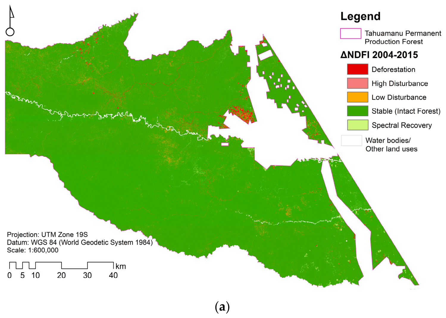
| Deforestation | <−0.45 | Complete loss of canopy cover; transition to bare ground or grassland. |
| High Disturbance | −0.45 < ΔNDFI ≤ −0.38 | Construction of logging yards and main roads. |
| Low Disturbance | −0.38 < ΔNDFI ≤ −0.23 | Creation of logging clearings or narrow skid trails. |
| Stable (Intact Forest) | −0.23 < ΔNDFI ≤ 0.20 | No structural changes; intact forest structure. |
| Spectral Recovery | >0.20 | Closure of clearings through natural regeneration. |
| Period | Category | UA (%) | PA (%) | Commission Error (%) | Omission Error (%) |
|---|---|---|---|---|---|
| 2004–2015 | Stable (Intact Forest) | 98.7 | 98.7 | 1.3 | 1.3 |
| Low Disturbance | 88.3 | 87.2 | 11.7 | 12.8 | |
| High Disturbance | 88.3 | 90.7 | 11.7 | 9.3 | |
| Deforestation | 97.4 | 96.2 | 2.6 | 3.8 | |
| Spectral Recovery | 93.4 | 93.4 | 6.6 | 6.6 | |
| Overall Accuracy | 93.2% | — | — | ||
| 2015–2025 | Stable (Intact Forest) | 98.7 | 98.7 | 1.3 | 1.3 |
| Low Disturbance | 88.3 | 88.3 | 11.7 | 11.7 | |
| High Disturbance | 88.3 | 89.5 | 11.7 | 10.5 | |
| Deforestation | 97.4 | 96.2 | 2.6 | 3.8 | |
| Spectral Recovery | 94.7 | 94.7 | 5.3 | 5.3 | |
| Overall Accuracy | 93.5% | — | — | ||
| 2004–2025 | Stable (Intact Forest) | 98.7 | 98.7 | 1.3 | 1.3 |
| Low Disturbance | 87 | 87 | 13 | 13 | |
| High Disturbance | 89.6 | 88.5 | 10.4 | 11.5 | |
| Deforestation | 96.1 | 97.4 | 3.9 | 2.6 | |
| Spectral Recovery | 93.4 | 93.4 | 6.6 | 6.6 | |
| Overall Accuracy | 93.0% | — | — | ||
| Category | 2004 (ha) | 2004 (%) | 2015 (ha) | 2015 (%) | 2025 (ha) | 2025 (%) |
|---|---|---|---|---|---|---|
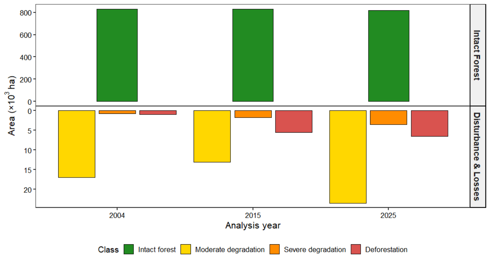
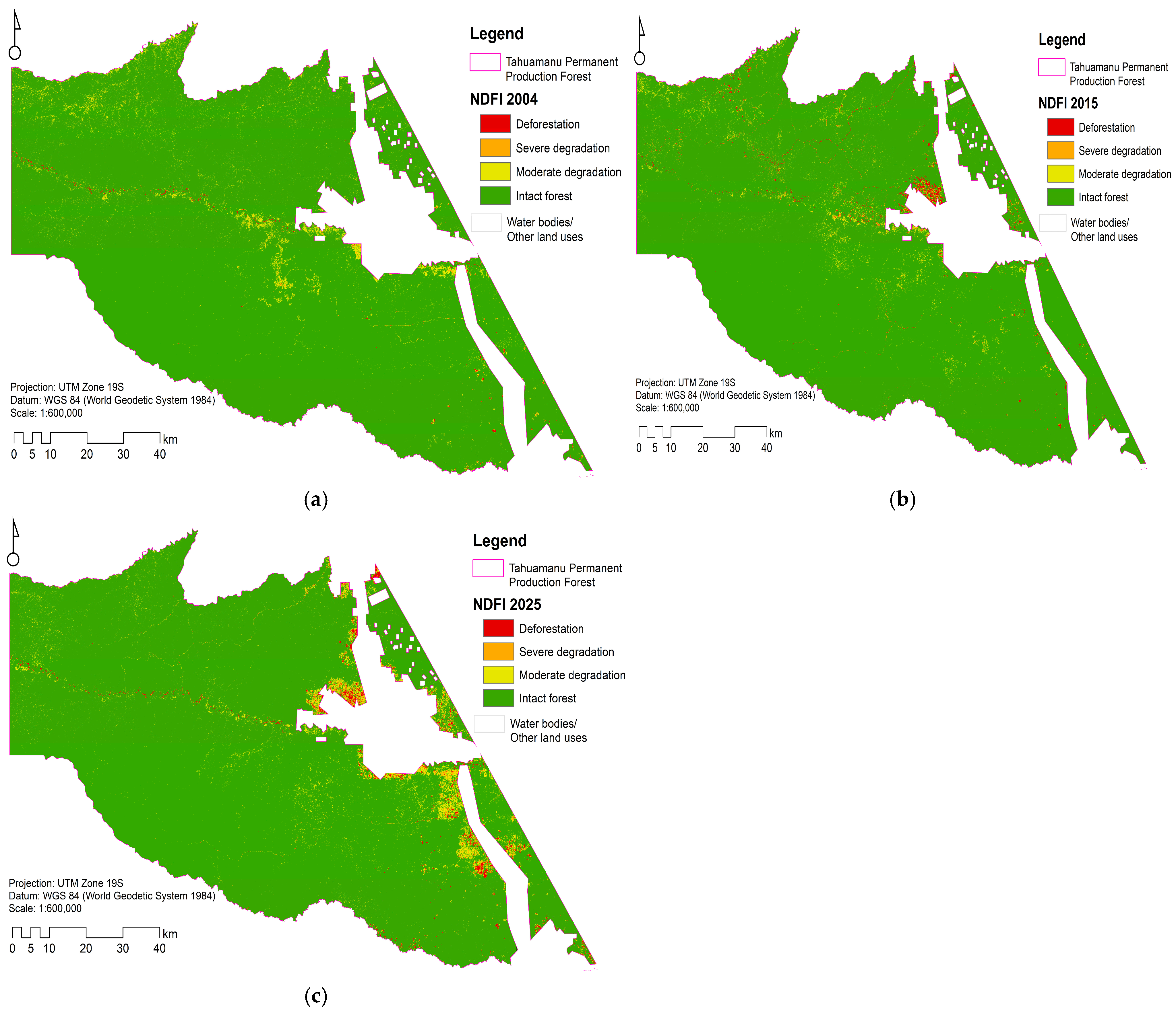
| Intact forest | 831,188 | 97.8 | 829,540 | 97.6 | 816,269 | 96.0 |
| Moderate degradation | 16,907 | 2.0 | 13,070 | 1.5 | 23,496 | 2.8 |
| Severe degradation | 748 | 0.1 | 1722 | 0.2 | 3505 | 0.4 |
| Total degradation (Sum) | 17,655 | 2.1 | 14,792 | 1.7 | 27,002 | 3.2 |
| Deforestation | 995 | 0.1 | 5506 | 0.6 | 6567 | 0.8 |
| Total study area | 849,838 | 100.0 | 849,838 | 100.0 | 849,838 | 100.0 |
| Category | Period | Net Change (ha) | Annual Change (ha⋅year−1) | Annual Rate (r%⋅year−1) |
|---|---|---|---|---|
| Intact forest | 2004–2015 | 1648 | 150 | −0.02 |
| 2015–2025 | 13,271 | 1327 | −0.16 | |
| 2004–2025 | 14,919 | 710 | −0.09 | |
| Moderate degradation | 2004–2015 | 3837 | 349 | −2.31 |
| 2015–2025 | −10,426 | −1043 | 6.04 | |
| 2004–2025 | −6589 | −314 | 1.58 | |
| Severe degradation | 2004–2015 | −974 | −89 | 7.87 |
| 2015–2025 | −1783 | −178 | 7.36 | |
| 2004–2025 | −2757 | −131 | 7.63 | |
| Total degradation (Sum) | 2004–2015 | 2863 | 260 | −1.60 |
| 2015–2025 | −12,209 | −1221 | 6.20 | |
| 2004–2025 | −9346 | −445 | 2.04 | |
| Deforestation | 2004–2015 | −4511 | −410 | 16.83 |
| 2015–2025 | −1062 | −106 | 1.78 | |
| 2004–2025 | −5573 | −265 | 9.40 |
| Transition Trajectory | Change Category | Mapped Area (ha) | Adjusted Area (ha) | SE (ha) | 95% CI (ha) |
|---|---|---|---|---|---|
| 2004–2015 | |||||
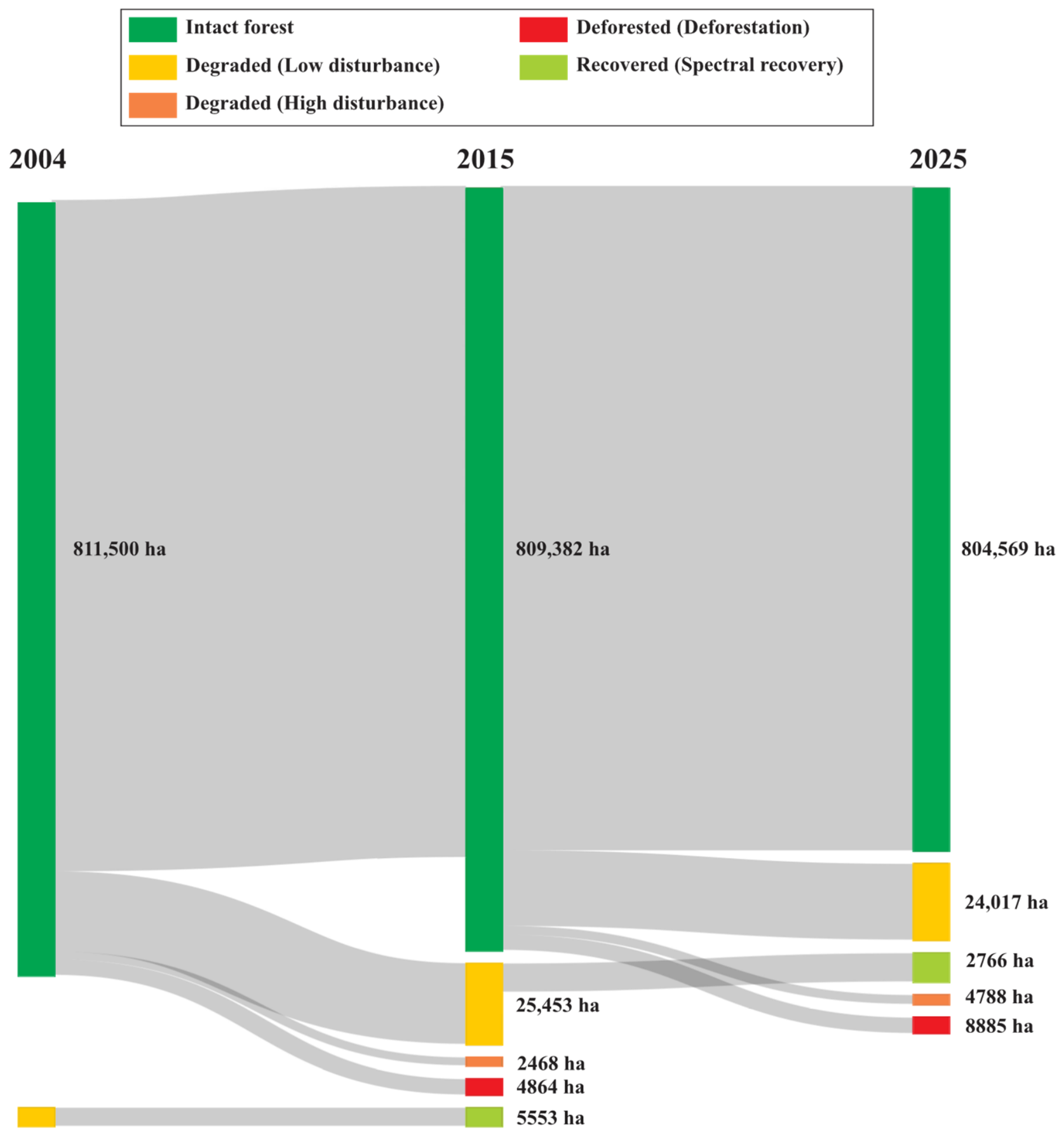
| Stable (Intact Forest) | Stable (Intact Forest) | 821,953 | 811,500 | 10,677 | 790,574–832,427 |
| Intact Forest–Degraded | Low Disturbance | 16,327 | 25,453 | 10,693 | 4496–46,411 |
| Intact Forest–Degraded | High Disturbance | 1613 | 2468 | 434 | 1617–3319 |
| Intact Forest–Degraded | Total Disturbance | 17,940 | 27,921 | 10,686 | 6976–48,866 |
| Intact Forest–Deforested | Deforestation | 4916 | 4864 | 97 | 4674–5054 |
| Degraded–Recovered | Spectral Recovery | 5029 | 5553 | 440 | 4690–6415 |
| 2015–2025 | |||||
| Stable (Intact Forest) | Stable (Intact Forest) | 819,835 | 809,382 | 10,649 | 788,509–830,253 |
| Intact Forest–Degraded | Low Disturbance | 14,604 | 24,017 | 10,663 | 3118–44,916 |
| Intact Forest–Degraded | High Disturbance | 1818 | 2766 | 443 | 1898–3634 |
| Intact Forest–Degraded | Total Disturbance | 16,422 | 26,783 | 10,657 | 5897–47,671 |
| Intact Forest–Deforested | Deforestation | 4845 | 4788 | 97 | 4598–4978 |
| Degraded–Recovered | Spectral Recovery | 8736 | 8885 | 396 | 8109–9661 |
| 2004–2025 | |||||
| Stable (Intact Forest) | Stable (Intact Forest) | 814,873 | 804,569 | 10,586 | 783,821–825,318 |
| Intact Forest–Degraded | Low Disturbance | 18,700 | 27,404 | 10,610 | 6609–48,200 |
| Intact Forest–Degraded | High Disturbance | 2054 | 3389 | 561 | 2290–4488 |
| Intact Forest–Degraded | Total Disturbance | 20,755 | 30,793 | 10,600 | 10,017–51,569 |
| Intact Forest–Deforested | Deforestation | 6237 | 6015 | 143 | 5736–6295 |
| Degraded–Recovered | Spectral Recovery | 7973 | 8461 | 529 | 7424–9497 |
Disclaimer/Publisher’s Note: The statements, opinions and data contained in all publications are solely those of the individual author(s) and contributor(s) and not of MDPI and/or the editor(s). MDPI and/or the editor(s) disclaim responsibility for any injury to people or property resulting from any ideas, methods, instructions or products referred to in the content. |
© 2026 by the authors. Licensee MDPI, Basel, Switzerland. This article is an open access article distributed under the terms and conditions of the Creative Commons Attribution (CC BY) license.
Share and Cite
Alarcon-Aguirre, G.; Canahuire-Robles, R.; Rondan Yupanqui, C.A.; García Roca, M.R.; Rodriguez Achata, L.; Zevallos Pollito, P.A.; Ramos Enciso, D.; Vela-Da-Fonseca, M.; Garate-Quispe, J. Dynamics of Forest Disturbance in the Canopy of Permanent Production Forests: A Multitemporal Analysis (2004–2025) Using Spectral Unmixing in the Southeastern Peruvian Amazon. Remote Sens. 2026, 18, 2813. https://doi.org/10.3390/rs18162813
Alarcon-Aguirre G, Canahuire-Robles R, Rondan Yupanqui CA, García Roca MR, Rodriguez Achata L, Zevallos Pollito PA, Ramos Enciso D, Vela-Da-Fonseca M, Garate-Quispe J. Dynamics of Forest Disturbance in the Canopy of Permanent Production Forests: A Multitemporal Analysis (2004–2025) Using Spectral Unmixing in the Southeastern Peruvian Amazon. Remote Sensing. 2026; 18(16):2813. https://doi.org/10.3390/rs18162813
Chicago/Turabian StyleAlarcon-Aguirre, Gabriel, Rembrandt Canahuire-Robles, Cesar Agusto Rondan Yupanqui, Mishari Rolando García Roca, Liset Rodriguez Achata, Percy A. Zevallos Pollito, Dalmiro Ramos Enciso, Mauro Vela-Da-Fonseca, and Jorge Garate-Quispe. 2026. "Dynamics of Forest Disturbance in the Canopy of Permanent Production Forests: A Multitemporal Analysis (2004–2025) Using Spectral Unmixing in the Southeastern Peruvian Amazon" Remote Sensing 18, no. 16: 2813. https://doi.org/10.3390/rs18162813
APA StyleAlarcon-Aguirre, G., Canahuire-Robles, R., Rondan Yupanqui, C. A., García Roca, M. R., Rodriguez Achata, L., Zevallos Pollito, P. A., Ramos Enciso, D., Vela-Da-Fonseca, M., & Garate-Quispe, J. (2026). Dynamics of Forest Disturbance in the Canopy of Permanent Production Forests: A Multitemporal Analysis (2004–2025) Using Spectral Unmixing in the Southeastern Peruvian Amazon. Remote Sensing, 18(16), 2813. https://doi.org/10.3390/rs18162813