Geometry-Aware InSAR Feedback Purification Sampling for Negative Sample Selection in Landslide Susceptibility Assessment: A Case Study in the Shigatse Region


Highlights
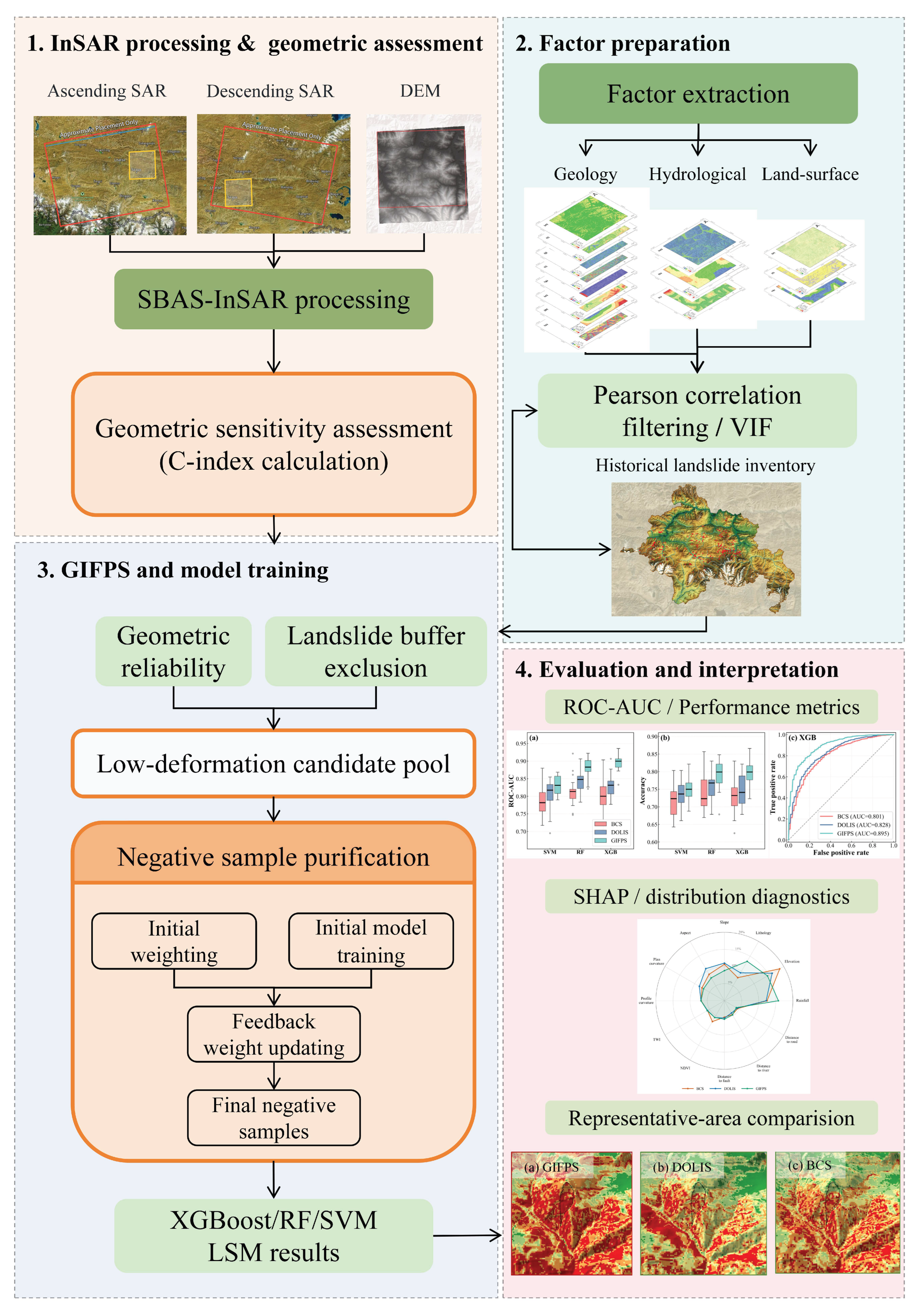
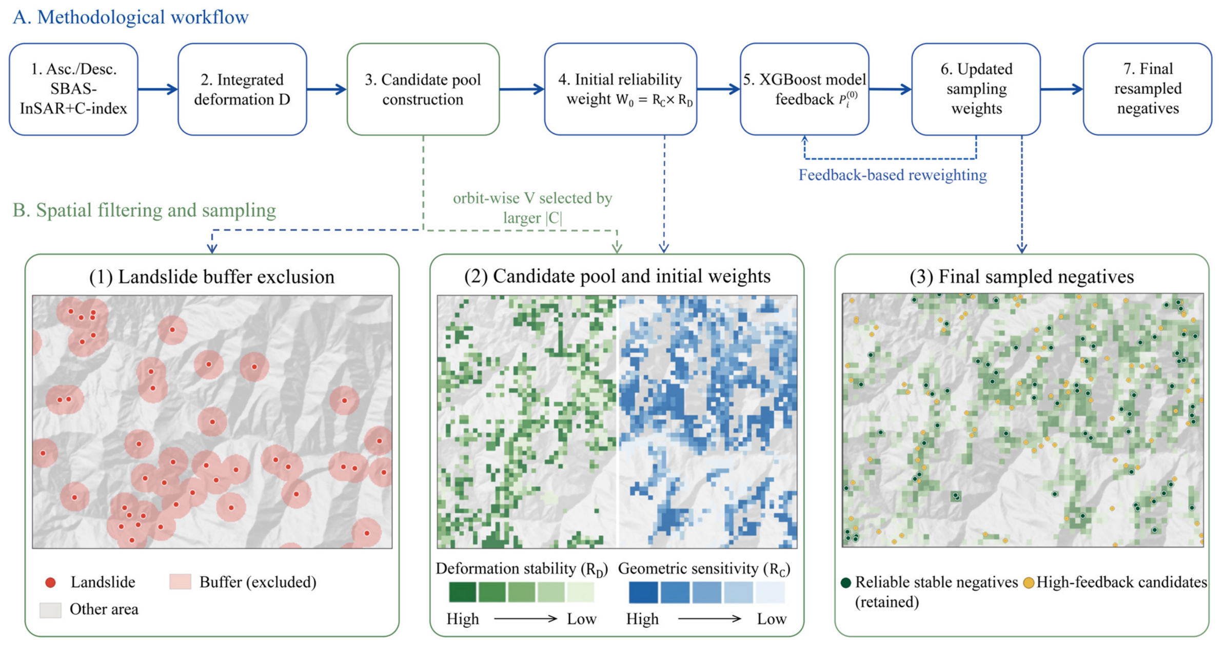
- We propose a geometry-aware InSAR feedback purification sampling strategy (GIFPS) for negative sample selection in landslide susceptibility assessment.
- GIFPS improves model performance compared with buffer-controlled sampling and dual-orbit low-deformation intersection sampling.
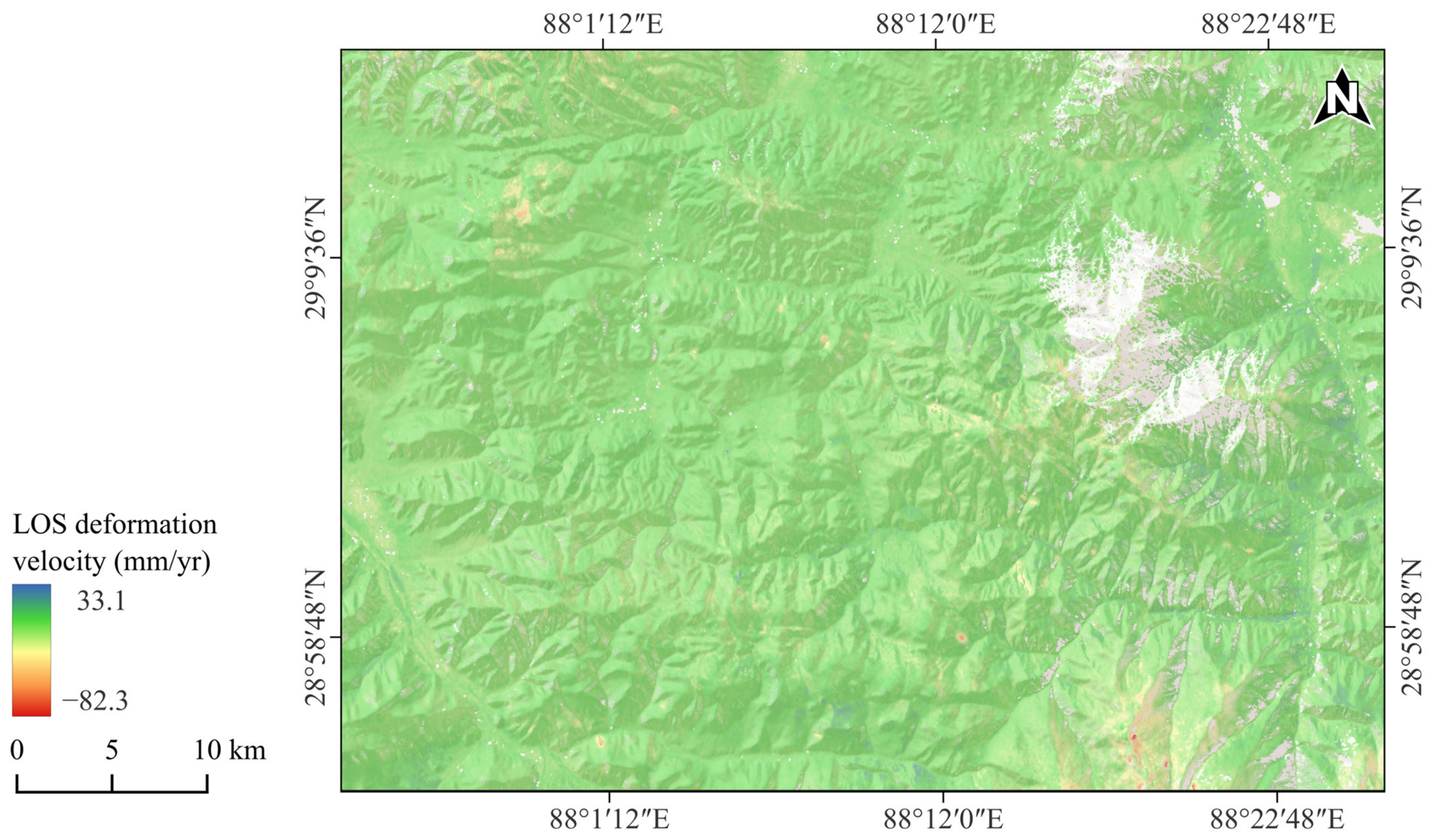
- The results indicate that considering line-of-sight geometric sensitivity is important when using low SBAS-InSAR deformation to select candidate negative samples.
- The improvement of GIFPS is mainly related to reliability-oriented sample selection rather than excessive narrowing of the candidate sample distribution.
Abstract
1. Introduction
2. Study Area and Data
2.1. Study Area
2.2. SAR Data
2.3. Landslide Conditioning Factors and Data Sources
2.3.1. Historical Landslides and Geological Data
2.3.2. Topography and Land-Cover Data
2.3.3. Hydrometeorological and Infrastructure Data
2.3.4. NDVI
3. Methods
3.1. SBAS-InSAR Surface Deformation Monitoring
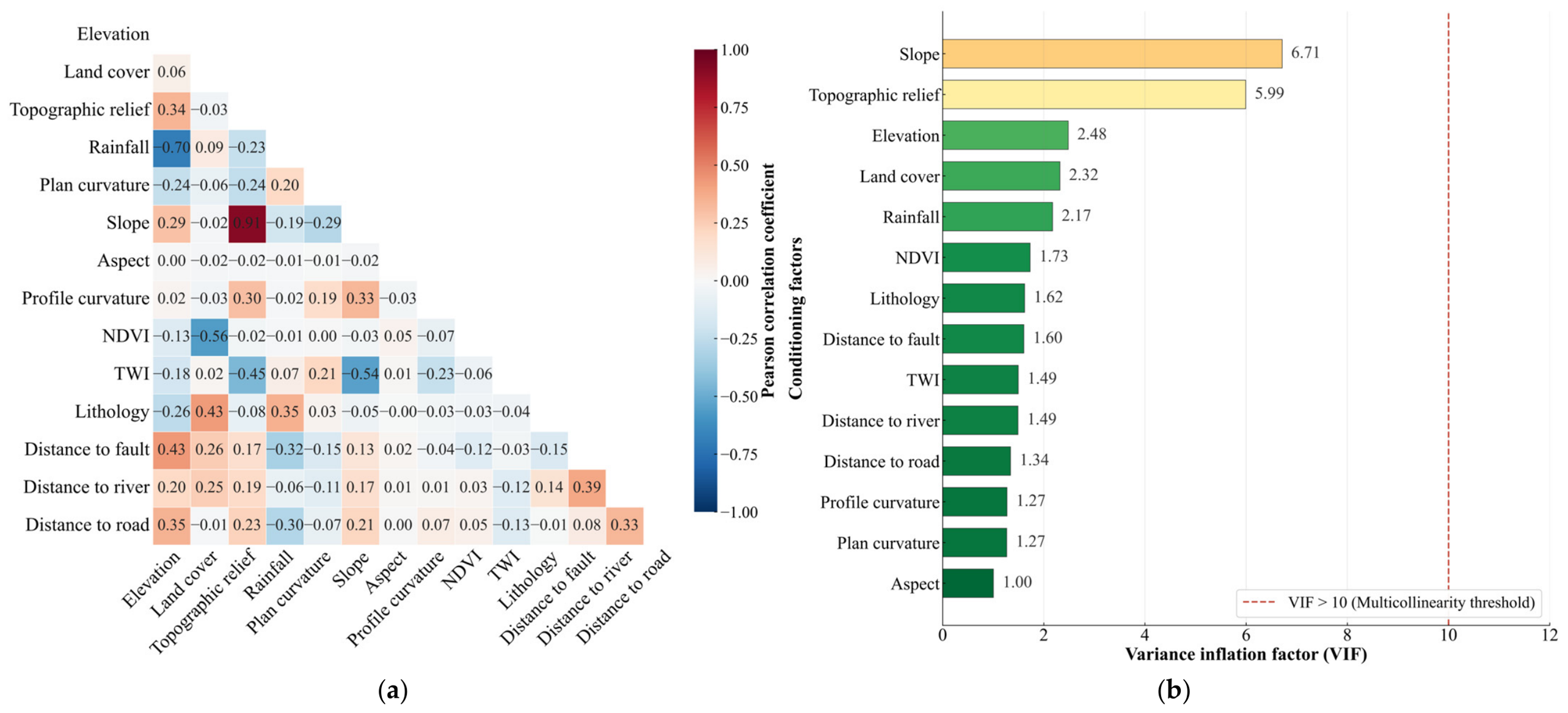
3.2. Conditioning Factor Screening
3.3. Geometry-Aware InSAR Feedback Purification Sampling
3.3.1. Construction of the Candidate Negative Sample Pool
3.3.2. Determination of Initial Sampling Weights
3.3.3. Model Feedback Purification
3.4. XGBoost Model
3.5. Spatial Block Cross-Validation
3.6. Evaluation Metrics
3.6.1. ROC Curve and AUC
3.6.2. Confusion-Matrix-Based Metrics
3.6.3. Sample-Distribution Diagnostics
4. Results
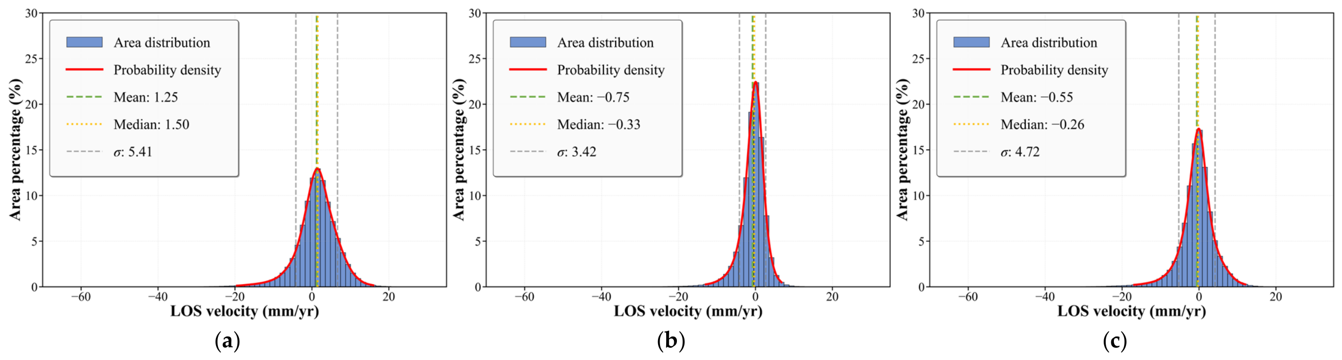
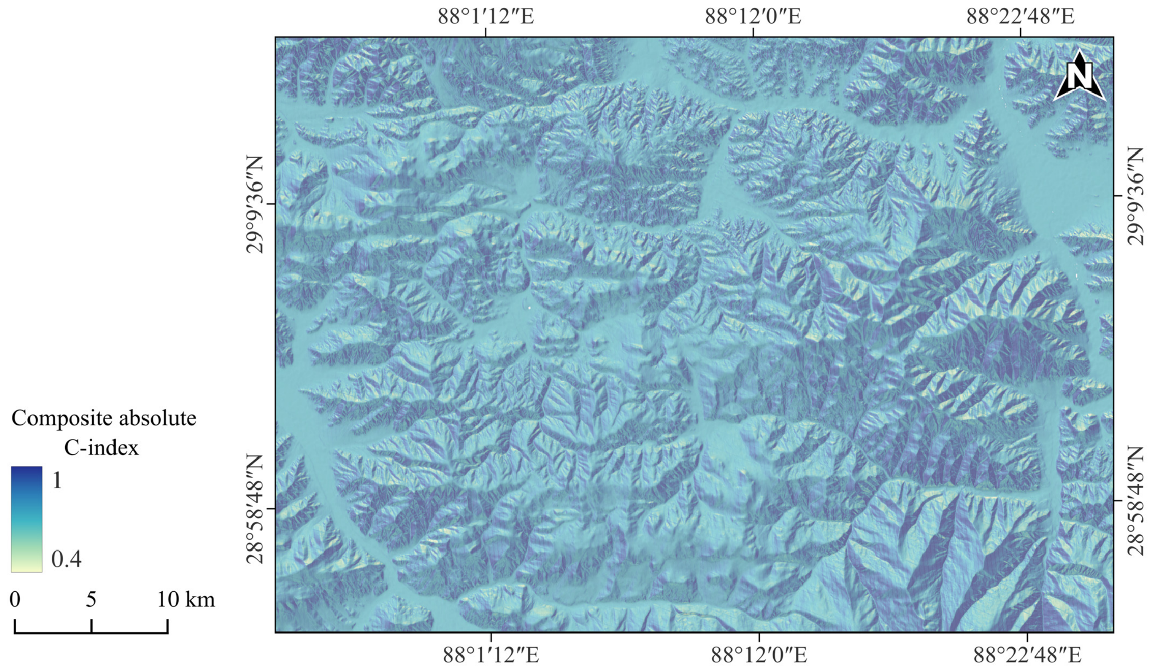
4.1. SBAS-InSAR and Geometric Sensitivity Results
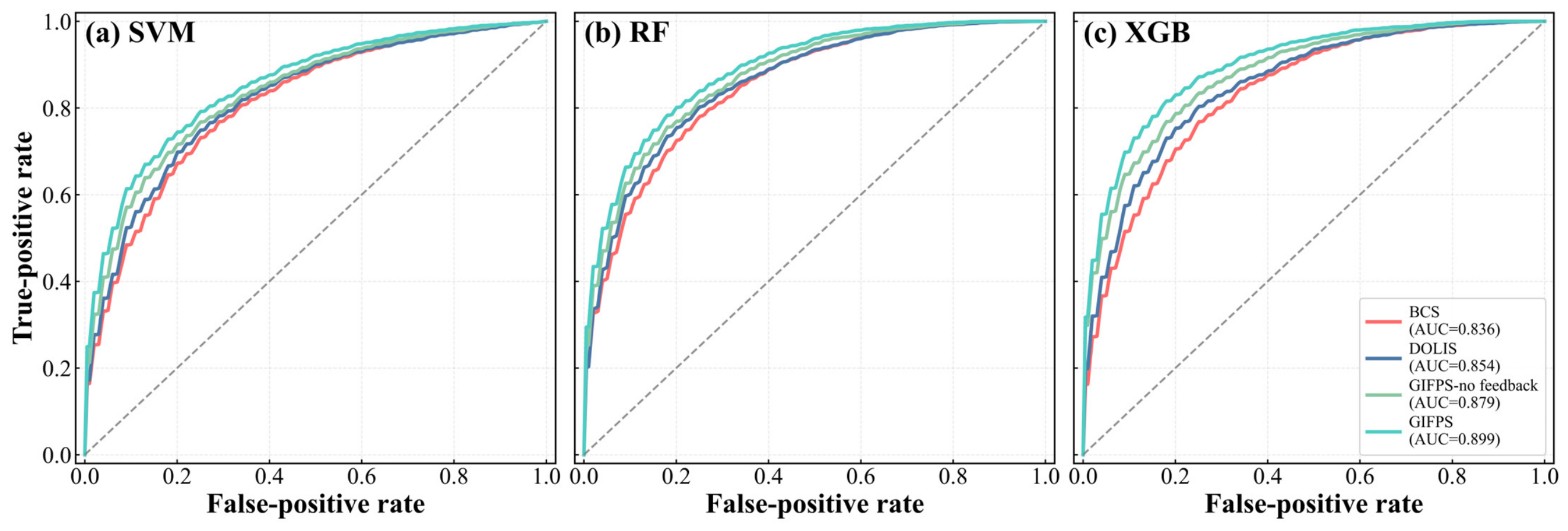
4.2. Performance of the Landslide Susceptibility Mapping
4.3. Results of Landslide Susceptibility Mapping
5. Discussion
5.1. Effect of GIFPS on Sample Selection and Model Behavior
5.2. Spatial Interpretation in Representative Landslide Areas
5.3. Effect of Spatial Autocorrelation on Model Evaluation
5.4. Comparison with Previous Studies and Limitations
6. Conclusions
- (1)
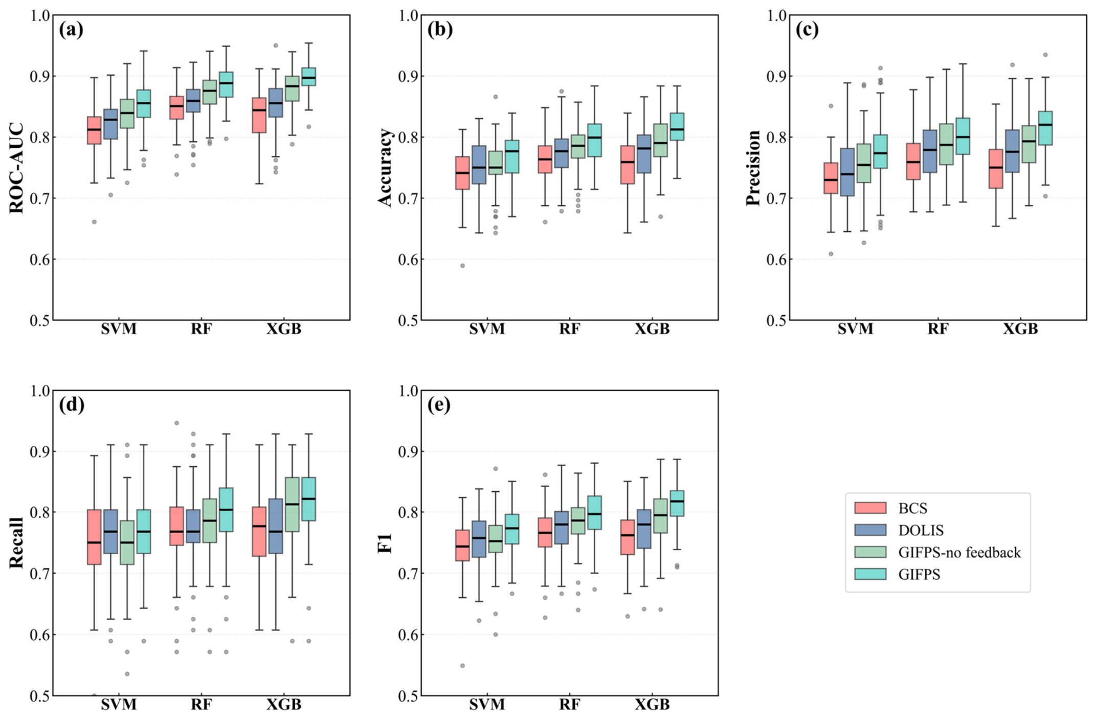
- In terms of predictive performance, GIFPS outperforms the commonly used BCS method and DOLIS. Across SVM, RF, and XGBoost classifiers, GIFPS achieves higher ROC-AUC and F1-score values. The improvement is confirmed by repeated experiments and Wilcoxon signed-rank tests. Ablation experiments further indicate that removing model feedback leads to a consistent decrease in performance, confirming its contribution within the GIFPS framework.
- (2)
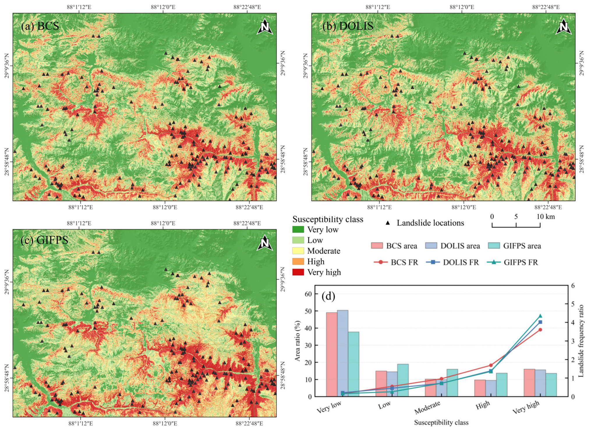
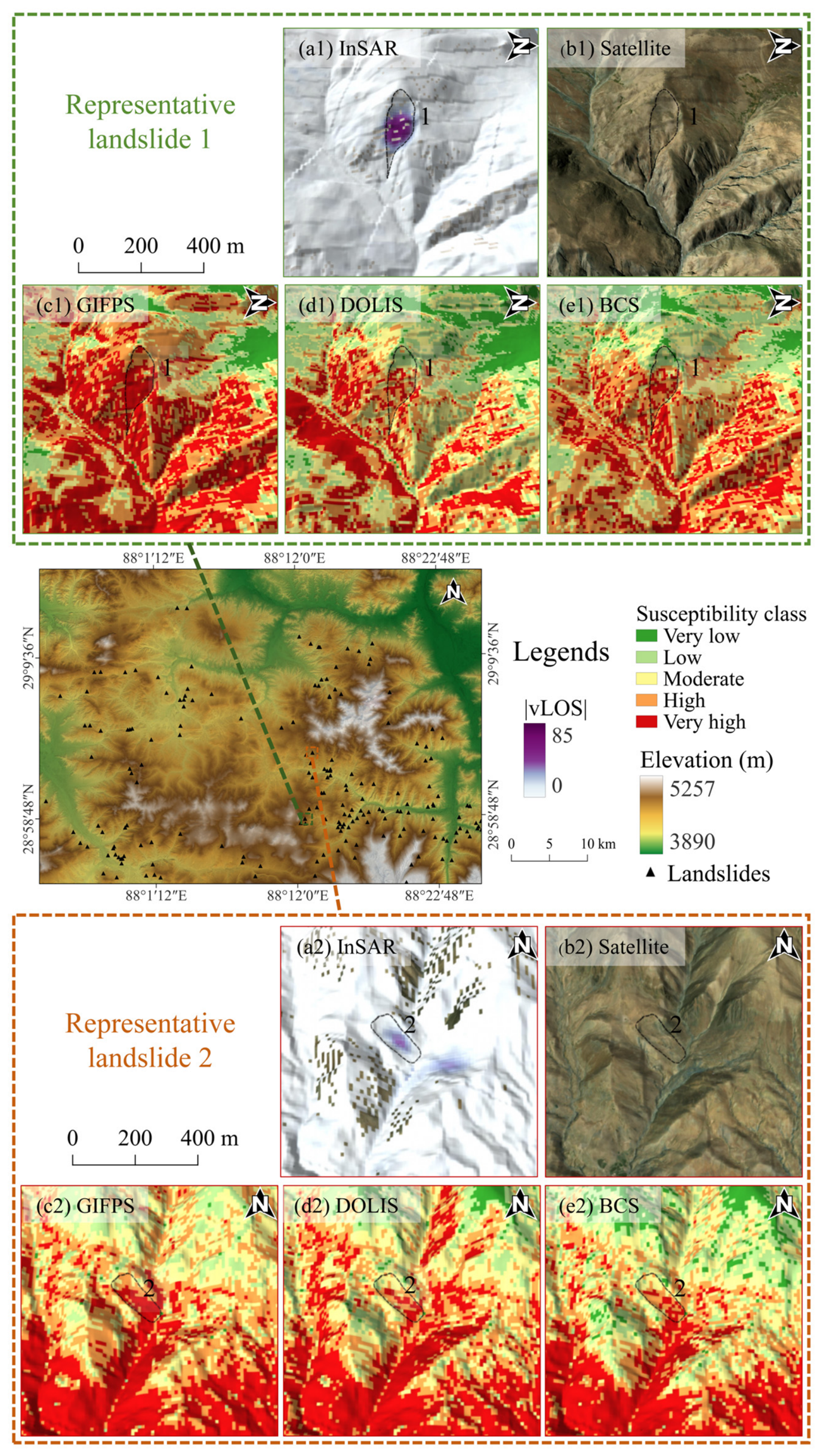
- The susceptibility map generated using GIFPS shows better spatial discrimination. The very-high-susceptibility zones contain a higher proportion of historical landslide points within a relatively limited area, while the low-susceptibility zones contain fewer historical landslide points. This indicates that GIFPS improves the spatial separation between susceptibility classes.
- (3)
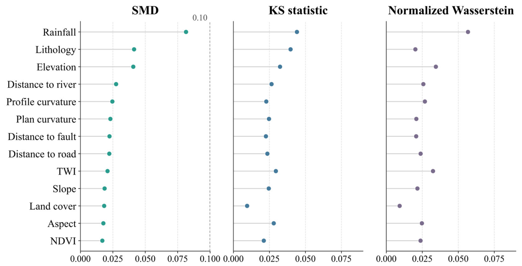
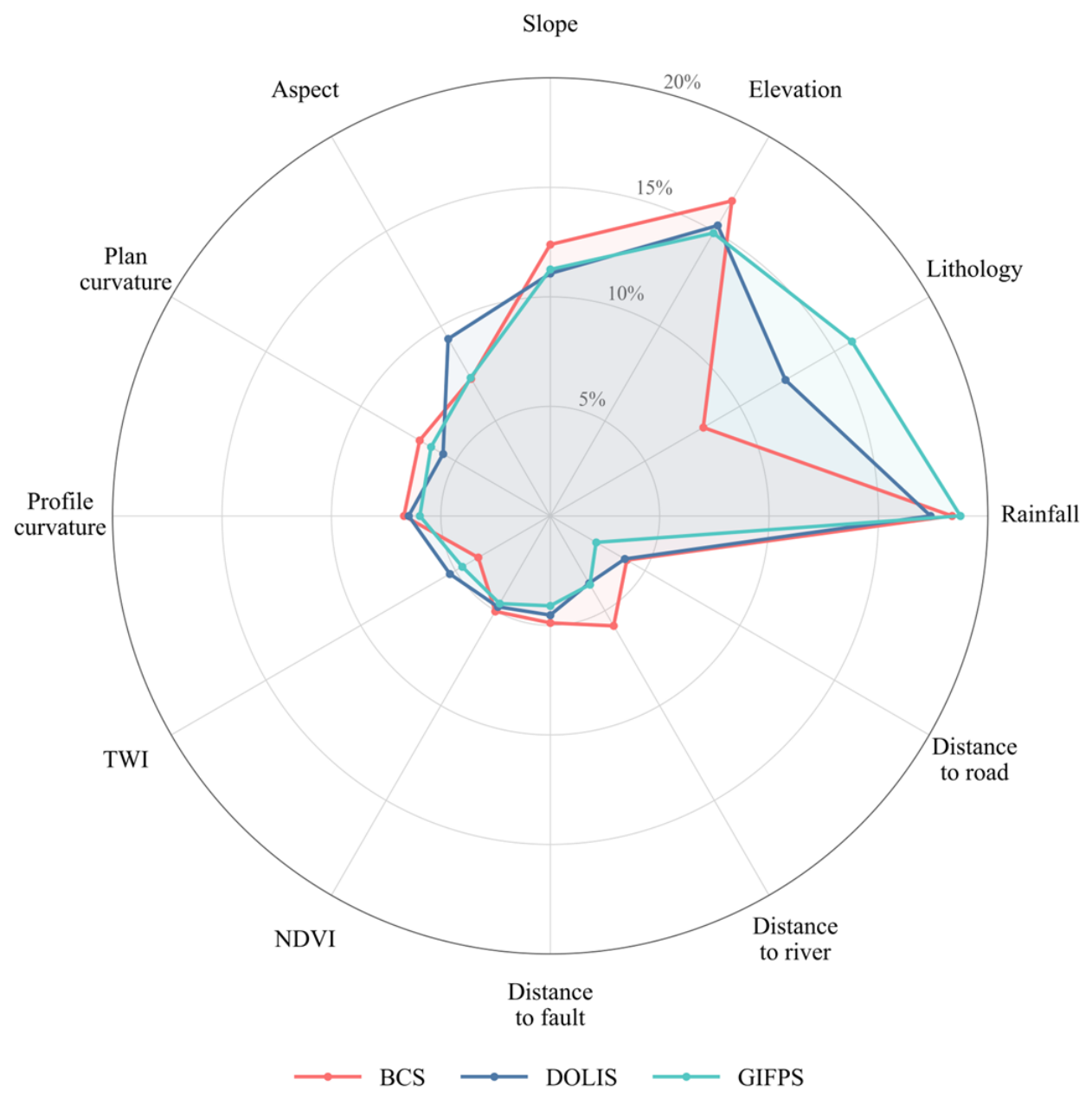
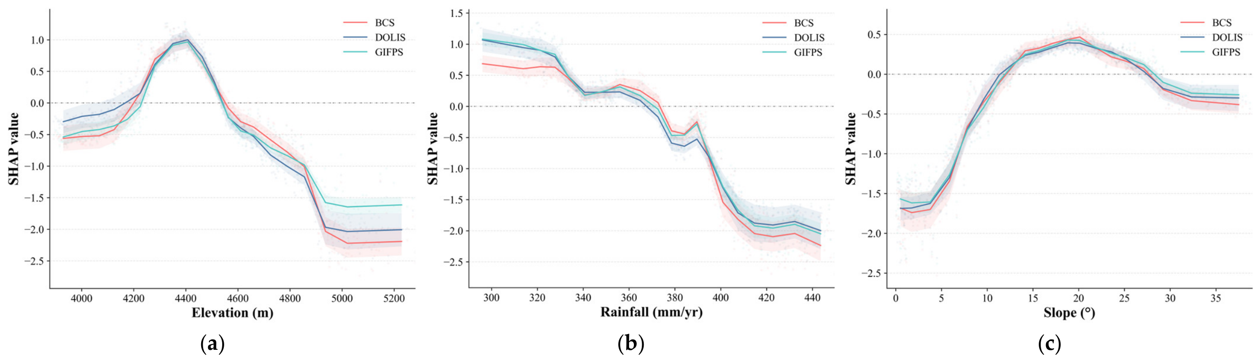
- From the perspectives of sample-distribution diagnostics and model interpretation, GIFPS alters the relative contributions of the conditioning factors but does not substantially narrow their distributions in the final negative samples relative to the candidate pool. The SMD, KS statistic, and normalized Wasserstein distance consistently indicate that the final negative samples largely preserve the conditioning-factor distributions of the candidate pool. Therefore, the performance gain of GIFPS is more likely attributable to improved negative sample reliability than to an artificially simplified classification task.
Supplementary Materials
Author Contributions
Funding
Data Availability Statement
Conflicts of Interest
References
- Niyokwiringirwa, P.; Gall, T.; Jha, A.K. Toward a Standard for Landslide Data: Bridging Gaps in Landslide Susceptibility Modeling and Early Warning Systems; World Bank: Washington, DC, USA, 2026; Available online: https://documents.worldbank.org/en/publication/documents-reports/documentdetail/099321402252610889 (accessed on 20 July 2026).
- Duan, Y.; Ding, M.; He, Y.; Zheng, H.; Delgado-Téllez, R.; Sokratov, S.; Dourado, F.; Fuchs, S. Global Projections of Future Landslide Susceptibility under Climate Change. Geosci. Front. 2025, 16, 102074. [Google Scholar] [CrossRef] [Scilit]
- Zhang, Q.; Ma, W.; Gao, Y.; Zhang, T.; Ma, X.; Li, L.; Zhou, Q.; Liu, F. Zoning of the Disaster-Inducing Environment and Driving Factors for Landslides, Collapses, and Debris Flows on the Qinghai–Tibet Plateau. Appl. Sci. 2025, 15, 6569. [Google Scholar] [CrossRef] [Scilit]
- Zhao, B.; Su, L.; Xu, Q.; Li, W.; Xu, C.; Wang, Y. A Review of Recent Earthquake-Induced Landslides on the Tibetan Plateau. Earth-Sci. Rev. 2023, 244, 104534. [Google Scholar] [CrossRef] [Scilit]
- Dong, A.; Dou, J.; Fu, Y.; Zhang, R.; Xing, K. Unraveling the Evolution of Landslide Susceptibility: A Systematic Review of 30-Years of Strategic Themes and Trends. Geocarto Int. 2023, 38, 2256308. [Google Scholar] [CrossRef] [Scilit]
- Tran, V.A.; Khuc, T.D.; Truong, X.Q.; Nguyen, A.B.; Phi, T.T. Application of Potential Machine Learning Models in Landslide Susceptibility Assessment: A Case Study of Van Yen District, Yen Bai Province, Vietnam. Quat. Sci. Adv. 2024, 14, 100181. [Google Scholar] [CrossRef] [Scilit]
- Rai, S.C.; Pandey, V.K.; Sharma, K.K.; Sharma, S. Landslide Susceptibility Analysis in the Bhilangana Basin (India) Using GIS-Based Machine Learning Methods. Geosyst. Geoenviron. 2024, 3, 100253. [Google Scholar] [CrossRef] [Scilit]
- Yao, J.; Yao, X.; Zhao, Z.; Liu, X. Performance Comparison of Landslide Susceptibility Mapping under Multiple Machine-Learning Based Models Considering InSAR Deformation: A Case Study of the Upper Jinsha River. Geomat. Nat. Hazards Risk 2023, 14, 2212833. [Google Scholar] [CrossRef] [Scilit]
- Guo, Z.; Tian, B.; Zhu, Y.; He, J.; Zhang, T. How Do the Landslide and Non-Landslide Sampling Strategies Impact Landslide Susceptibility Assessment?—A Catchment-Scale Case Study from China. J. Rock Mech. Geotech. Eng. 2024, 16, 877–894. [Google Scholar] [CrossRef] [Scilit]
- Liu, Q.; Tang, A.; Huang, D. Exploring the Uncertainty of Landslide Susceptibility Assessment Caused by the Number of Non–Landslides. CATENA 2023, 227, 107109. [Google Scholar] [CrossRef] [Scilit]
- Huang, F.; Mao, D.; Jiang, S.-H.; Zhou, C.; Fan, X.; Zeng, Z.; Catani, F.; Yu, C.; Chang, Z.; Huang, J.; et al. Uncertainties in Landslide Susceptibility Prediction Modeling: A Review on the Incompleteness of Landslide Inventory and Its Influence Rules. Geosci. Front. 2024, 15, 101886. [Google Scholar] [CrossRef] [Scilit]
- Huang, F.; Xiong, H.; Jiang, S.-H.; Yao, C.; Fan, X.; Catani, F.; Chang, Z.; Zhou, X.; Huang, J.; Liu, K. Modelling Landslide Susceptibility Prediction: A Review and Construction of Semi-Supervised Imbalanced Theory. Earth-Sci. Rev. 2024, 250, 104700. [Google Scholar] [CrossRef] [Scilit]
- Hong, H.; Wang, D.; Zhu, A.-X.; Wang, Y. Landslide Susceptibility Mapping Based on the Reliability of Landslide and Non-Landslide Sample. Expert Syst. Appl. 2024, 243, 122933. [Google Scholar] [CrossRef] [Scilit]
- Yang, Y.; Zhang, R.; Wang, T.; Liu, A.; He, Y.; Lv, J.; He, X.; Mao, W.; Xiang, W.; Zhang, B. An Information Quantity and Machine Learning Integrated Model for Landslide Susceptibility Mapping in Jiuzhaigou, China. Nat. Hazards 2024, 120, 10185–10217. [Google Scholar] [CrossRef] [Scilit]
- Yang, L.; Cui, Y.; Xu, C.; Ma, S. Application of Coupling Physics–Based Model TRIGRS with Random Forest in Rainfall-Induced Landslide-Susceptibility Assessment. Landslides 2024, 21, 2179–2193. [Google Scholar] [CrossRef] [Scilit]
- Gu, T.; Duan, P.; Wang, M.; Li, J.; Zhang, Y. Effects of Non-Landslide Sampling Strategies on Machine Learning Models in Landslide Susceptibility Mapping. Sci. Rep. 2024, 14, 7201. [Google Scholar] [CrossRef] [Scilit] [PubMed]
- Wei, R.; Li, Y.; Li, Y.; Wang, Z.; Wu, C.; Wang, J.; Zhang, B.; Ye, C. Edge-Attentive Graph Convolutional Network and Positive-Unlabeled Framework for Landslide Susceptibility Mapping. Gondwana Res. 2025, 148, 240–254. [Google Scholar] [CrossRef] [Scilit]
- Cui, Y.; Deng, Q.; Miao, H. Application of a Relief-Optimized Method for Target Space Exteriorization Sampling in Landslide Susceptibility Assessment. J. Mt. Sci. 2025, 22, 3391–3407. [Google Scholar] [CrossRef] [Scilit]
- Gu, X.; Li, Y.; Zuo, X.; Bu, J.; Yang, F.; Yang, X.; Li, Y.; Zhang, J.; Huang, C.; Shi, C.; et al. Image Compression–Based DS-InSAR Method for Landslide Identification and Monitoring of Alpine Canyon Region: A Case Study of Ahai Reservoir Area in Jinsha River Basin. Landslides 2024, 21, 2501–2517. [Google Scholar] [CrossRef] [Scilit]
- Li, Z.; Chen, B.; Liu, Y.; Peng, J.; Xu, Q.; Jiang, L.; Du, J.; Song, C.; Ding, M.; Zhu, W. Long-Term Three-Dimensional Deformation Monitoring and Risk Assessment of the Guba Landslide, Tibetan Plateau. Sci. China Earth Sci. 2025, 68, 3288–3305. [Google Scholar] [CrossRef] [Scilit]
- Ran, S.; Zhou, W.; Weng, Y.; Chi, F.; Wang, D.; Cao, X.; Ma, G. Causative Environment-Informed Active Landslide Detection with InSAR Monitoring: Empowering Reservoir Slope Hazard Management. Int. J. Appl. Earth Obs. Geoinf. 2026, 146, 105079. [Google Scholar] [CrossRef] [Scilit]
- Cheng, Y.; Pang, H.; Li, Y.; Fan, L.; Wei, S.; Yuan, Z.; Fang, Y. Applications and Advancements of Spaceborne InSAR in Landslide Monitoring and Susceptibility Mapping: A Systematic Review. Remote Sens. 2025, 17, 999. [Google Scholar] [CrossRef] [Scilit]
- Zhang, R.; Zhang, L.; Fang, Z.; Oguchi, T.; Merghadi, A.; Fu, Z.; Dong, A.; Dou, J. Interferometric Synthetic Aperture Radar (InSAR)-Based Absence Sampling for Machine-Learning-Based Landslide Susceptibility Mapping: The Three Gorges Reservoir Area, China. Remote Sens. 2024, 16, 2394. [Google Scholar] [CrossRef] [Scilit]
- Liu, Z.; Zhang, Z.; Zhang, W.; Ren, J.; Chen, Q. InSAR-Based Landslide Susceptibility Analysis in Karst Erosion Landforms Using a Non-Landslide Sampling Strategy. Int. J. Appl. Earth Obs. Geoinf. 2025, 145, 104997. [Google Scholar] [CrossRef] [Scilit]
- Xu, S.; Song, Y.; Lu, P.; Mu, G.; Yang, K.; Wang, S. An Optimized Non-Landslide Sampling Method for Landslide Susceptibility Evaluation Using Machine Learning Models. Nat. Hazards 2025, 121, 5873–5900. [Google Scholar] [CrossRef] [Scilit]
- Hanssen, R.F. Stochastic Model for Radar Interferometry. In Radar Interferometry: Data Interpretation and Error Analysis; Springer: Dordrecht, The Netherlands, 2001; pp. 81–159. [Google Scholar]
- Sharifi, S.; Macciotta, R.; Hendry, M.; Rotheram-Clarke, D.; Huntley, D. Evaluating Topography-Based Methods in 3D Decomposition of InSAR 1D Velocities Obtained for Translational Landslides: Thompson River Valley in Canada. Landslides 2024, 21, 411–427. [Google Scholar] [CrossRef] [Scilit]
- Guo, R.; Li, S.; Chen, Y.; Li, X.; Yuan, L. Identification and Monitoring Landslides in Longitudinal Range-Gorge Region with InSAR Fusion Integrated Visibility Analysis. Landslides 2021, 18, 551–568. [Google Scholar] [CrossRef] [Scilit]
- Yang, S.; Li, D.; Liu, Y.; Xu, Z.; Sun, Y.; She, X. Landslide Identification in Human-Modified Alpine and Canyon Area of the Niulan River Basin Based on SBAS-InSAR and Optical Images. Remote Sens. 2023, 15, 1998. [Google Scholar] [CrossRef] [Scilit]
- Torre, D.; Galve, J.P.; Reyes-Carmona, C.; Alfonso-Jorde, D.; Ballesteros, D.; Menichetti, M.; Piacentini, D.; Troiani, F.; Azañón, J.M. Geomorphological Assessment as Basic Complement of InSAR Analysis for Landslide Processes Understanding. Landslides 2024, 21, 1273–1292. [Google Scholar] [CrossRef] [Scilit]
- Plank, S.; Singer, J.; Minet, C.; Thuro, K. Pre-Survey Suitability Evaluation of the Differential Synthetic Aperture Radar Interferometry Method for Landslide Monitoring. Int. J. Remote Sens. 2012, 33, 6623–6637. [Google Scholar] [CrossRef] [Scilit]
- Zhang, J.; Zuo, X.; Li, Y.; Shi, M.; Shi, C.; Huang, C.; Tang, X. Detection and Assessment of Potential Landslides in the Xiaojiang River Basin Using SBAS-InSAR. Sci. Rep. 2025, 15, 16082. [Google Scholar] [CrossRef] [Scilit] [PubMed]
- Li, X.; Fan, Q.; Niu, Y.; Zhang, S.; Zhao, J.; Si, J.; Wang, Z.; Ju, Z.; Lu, Z. A Two-Dimensional InSAR-Based Framework for Landslide Identification and Movement Pattern Classification. Remote Sens. 2025, 17, 3889. [Google Scholar] [CrossRef] [Scilit]
- Sun, K.; Li, Z.; Wang, S.; Hu, R. A Support Vector Machine Model of Landslide Susceptibility Mapping Based on Hyperparameter Optimization Using the Bayesian Algorithm: A Case Study of the Highways in the Southern Qinghai–Tibet Plateau. Nat. Hazards 2024, 120, 11377–11398. [Google Scholar] [CrossRef] [Scilit]
- Huang, F.; Liu, K.; Jiang, S.; Catani, F.; Liu, W.; Fan, X.; Huang, J. Optimization Method of Conditioning Factors Selection and Combination for Landslide Susceptibility Prediction. J. Rock Mech. Geotech. Eng. 2025, 17, 722–746. [Google Scholar] [CrossRef] [Scilit]
- Sajadi, P.; Sang, Y.-F.; Gholamnia, M.; Bonafoni, S.; Mukherjee, S. Evaluation of the Landslide Susceptibility and Its Spatial Difference in the Whole Qinghai-Tibetan Plateau Region by Five Learning Algorithms. Geosci. Lett. 2022, 9, 9. [Google Scholar] [CrossRef] [Scilit]
- Zhang, C. 1:100000 Geological Hazard Distribution Data of China Nepal Transportation Corridor (2022–2023). 2023. Available online: https://data.tpdc.ac.cn/zh-hans/data/f252a14d-91d9-4fed-9b7b-638c671d6399 (accessed on 16 January 2026).
- Xu, X. China Active Fault Database. 2023. Available online: https://github.com/gmt-china/china-geospatial-data/releases (accessed on 16 January 2026).
- Steinshouer, D.W.; Qiang, J.; McCabe, P.J.; Ryder, R.T. Maps Showing Geology, Oil and Gas Fields, and Geologic Provinces of the Asia Pacific Region. 1999. Available online: https://pubs.usgs.gov/of/1997/ofr-97-470/OF97-470F/ (accessed on 17 January 2026).
- Zanaga, D.; Van De Kerchove, R.; De Keersmaecker, W.; Souverijns, N.; Brockmann, C.; Quast, R.; Wevers, J.; Grosu, A.; Paccini, A.; Vergnaud, S.; et al. ESA WorldCover 10 m 2020 V100. 2021. Available online: https://zenodo.org/record/5571936 (accessed on 9 February 2026).
- Yue, D. Grid Dataset of Meteorological Elements for 1km of China Nepal Transportation Corridor (1992–2022). 2024. Available online: https://data.tpdc.ac.cn/zh-hans/data/e5daef81-b973-4cce-b7e8-82a0ad03dfc8 (accessed on 18 January 2026).
- Zhao, B. China-Nepal Transport Corridor 1:10 00000 Stream Data Set (2017). 2017. Available online: https://data.tpdc.ac.cn/zh-hans/data/244f6fa0-ded1-4a29-9c21-3486405a2c8b (accessed on 16 January 2026).
- Berardino, P.; Fornaro, G.; Lanari, R.; Sansosti, E. A New Algorithm for Surface Deformation Monitoring Based on Small Baseline Differential SAR Interferograms. IEEE Trans. Geosci. Remote Sens. 2002, 40, 2375–2383. [Google Scholar] [CrossRef] [Scilit]
- Wang, F.; Wen, Z.; Gao, Q.; Yu, Q.; Li, D.; Chen, L. Thermokarst Landslides Susceptibility Evaluation across the Permafrost Region of the Central Qinghai-Tibet Plateau: Integrating a Machine Learning Model with InSAR Technology. J. Hydrol. 2024, 642, 131800. [Google Scholar] [CrossRef] [Scilit]
- Hussain, S.; Pan, B.; Hussain, W.; Sajjad, M.M.; Ali, M.; Afzal, Z.; Abdullah-Al-Wadud, M.; Tariq, A. Integrated PSInSAR and SBAS-InSAR Analysis for Landslide Detection and Monitoring. Phys. Chem. Earth Parts ABC 2025, 139, 103956. [Google Scholar] [CrossRef] [Scilit]
- Ullah, M.; Tang, B.; Huangfu, W.; Yang, D.; Wei, Y.; Qiu, H. Machine Learning-Driven Landslide Susceptibility Mapping in the Himalayan China–Pakistan Economic Corridor Region. Land 2024, 13, 1011. [Google Scholar] [CrossRef] [Scilit]
- Zhao, F.; Miao, F.; Wu, Y.; Ke, C.; Gong, S.; Ding, Y. Refined Landslide Susceptibility Mapping in Township Area Using Ensemble Machine Learning Method under Dataset Replenishment Strategy. Gondwana Res. 2024, 131, 20–37. [Google Scholar] [CrossRef] [Scilit]
- O’brien, R.M. A Caution Regarding Rules of Thumb for Variance Inflation Factors. Qual. Quant. 2007, 41, 673–690. [Google Scholar] [CrossRef] [Scilit]
- Xiong, Z.; Zhang, M.; Ma, J.; Xing, G.; Feng, G.; An, Q. InSAR-Based Landslide Detection Method with the Assistance of C-Index. Landslides 2023, 20, 2709–2723. [Google Scholar] [CrossRef] [Scilit]
- Dai, K.; Chen, Y.; Xu, Q.; Hancock, C.; Jiang, M.; Deng, J.; Zhuo, G. A Functional Model for Determining Maximum Detectable Deformation Gradients of InSAR Considering the Topography in Mountainous Areas. IEEE Trans. Geosci. Remote Sens. 2023, 61, 1–11. [Google Scholar] [CrossRef] [Scilit]
- Chen, B.; Jiang, J.; Wang, X.; Wan, P.; Wang, J.; Long, M. Debiased Self-Training for Semi-Supervised Learning. In Proceedings of the Advances in Neural Information Processing Systems; Koyejo, S., Mohamed, S., Agarwal, A., Belgrave, D., Cho, K., Oh, A., Eds.; Curran Associates, Inc.: Red Hook, NY, USA, 2022; Volume 35, pp. 32424–32437. [Google Scholar]
- Sahin, E.K. Assessing the Predictive Capability of Ensemble Tree Methods for Landslide Susceptibility Mapping Using XGBoost, Gradient Boosting Machine, and Random Forest. SN Appl. Sci. 2020, 2, 1308. [Google Scholar] [CrossRef] [Scilit]
- Tu, L.; Chen, M.; Leng, P.; Liu, S.; Liu, M.; Luo, W.; Mao, Y. Improving Landslide Susceptibility Assessment Through Non-Landslide Sampling Strategies. Land 2025, 14, 2059. [Google Scholar] [CrossRef] [Scilit]
- Shan, Y.; Xu, Z.; Zhou, S.; Lu, H.; Yu, W.; Li, Z.; Cao, X.; Li, P.; Li, W. Landslide Hazard Assessment Combined with InSAR Deformation: A Case Study in the Zagunao River Basin, Sichuan Province, Southwestern China. Remote Sens. 2023, 16, 99. [Google Scholar] [CrossRef] [Scilit]
- Qin, J.; Li, W.; Zhou, S.; Shan, Y.; He, G.; Fan, L. Optimizing Negative Sample Selection and Results for Landslide Susceptibility Assessment Using InSAR Surface Deformation. Geomat. Inf. Sci. Wuhan Univ. 2026, 51, 1228–1241. (In Chinese) [Google Scholar] [CrossRef]
- Austin, P.C. An Introduction to Propensity Score Methods for Reducing the Effects of Confounding in Observational Studies. Multivar. Behav. Res. 2011, 46, 399–424. [Google Scholar] [CrossRef] [Scilit] [PubMed]
- Wu, B.; Shi, Z.; Zheng, H.; Peng, M.; Meng, S. Impact of Sampling for Landslide Susceptibility Assessment Using Interpretable Machine Learning Models. Bull. Eng. Geol. Environ. 2024, 83, 461. [Google Scholar] [CrossRef] [Scilit]
- Zhao, F.; Miao, F.; Wu, Y.; Gong, S.; Qian, Z.; Zheng, G. Integration of Interpretable Machine Learning and MT-InSAR for Dynamic Enhancement of Landslide Susceptibility in the Three Gorges Reservoir Area. J. Rock Mech. Geotech. Eng. 2026, 18, 1193–1212. [Google Scholar] [CrossRef] [Scilit]
- Zhang, J.; Ma, X.; Zhang, J.; Sun, D.; Zhou, X.; Mi, C.; Wen, H. Insights into Geospatial Heterogeneity of Landslide Susceptibility Based on the SHAP-XGBoost Model. J. Environ. Manag. 2023, 332, 117357. [Google Scholar] [CrossRef] [Scilit] [PubMed]
- Fu, Z.; Ma, H.; Wang, F.; Dou, J.; Zhang, B.; Fang, Z. An Integrated Framework of Positive-Unlabeled and Imbalanced Learning for Landslide Susceptibility Mapping. IEEE J. Sel. Top. Appl. Earth Obs. Remote Sens. 2024, 17, 15596–15611. [Google Scholar] [CrossRef] [Scilit]
- Zhang, Q.; He, Y.; Zhang, L.; Lu, J.; Gao, B.; Yang, W.; Chen, H.; Zhang, Y. A Landslide Susceptibility Assessment Method Considering the Similarity of Geographic Environments Based on Graph Neural Network. Gondwana Res. 2024, 132, 323–342. [Google Scholar] [CrossRef] [Scilit]
- Liu, X.; Wang, S.; Liao, M. Landslide Susceptibility Assessment Incorporating Sample Optimization: A Case Study of Liujiaxia Reservoir Area. Remote Sens. Appl. Soc. Environ. 2026, 43, 102173. [Google Scholar] [CrossRef] [Scilit]
- Van Natijne, A.L.; Bogaard, T.A.; Van Leijen, F.J.; Hanssen, R.F.; Lindenbergh, R.C. World-Wide InSAR Sensitivity Index for Landslide Deformation Tracking. Int. J. Appl. Earth Obs. Geoinf. 2022, 111, 102829. [Google Scholar] [CrossRef] [Scilit]
- Bonì, R.; Bordoni, M.; Vivaldi, V.; Troisi, C.; Tararbra, M.; Lanteri, L.; Zucca, F.; Meisina, C. Assessment of the Sentinel-1 Based Ground Motion Data Feasibility for Large Scale Landslide Monitoring. Landslides 2020, 17, 2287–2299. [Google Scholar] [CrossRef] [Scilit]
- Wang, Y.; Dong, J.; Zhang, L.; Zhang, L.; Deng, S.; Zhang, G.; Liao, M.; Gong, J. Refined InSAR Tropospheric Delay Correction for Wide-Area Landslide Identification and Monitoring. Remote Sens. Environ. 2022, 275, 113013. [Google Scholar] [CrossRef] [Scilit]
- Li, S.; Xu, W.; Li, Z. Review of the SBAS InSAR Time-Series Algorithms, Applications, and Challenges. Geod. Geodyn. 2022, 13, 114–126. [Google Scholar] [CrossRef] [Scilit]
- Lu, J.; He, Y.; Zhang, L.; Zhang, Q.; Gao, B.; Chen, H.; Fang, Y. Ensemble Learning Landslide Susceptibility Assessment with Optimized Non-Landslide Samples Selection. Geomat. Nat. Hazards Risk 2024, 15, 2378176. [Google Scholar] [CrossRef] [Scilit]
- Liu, S.; Wang, L.; Zhang, W.; Sun, W.; Wang, Y.; Liu, J. Physics-Informed Optimization for a Data-Driven Approach in Landslide Susceptibility Evaluation. J. Rock Mech. Geotech. Eng. 2024, 16, 3192–3205. [Google Scholar] [CrossRef] [Scilit]
- Novellino, A.; Pennington, C.; Leeming, K.; Taylor, S.; Alvarez, I.G.; McAllister, E.; Arnhardt, C.; Winson, A. Mapping Landslides from Space: A Review. Landslides 2024, 21, 1041–1052. [Google Scholar] [CrossRef] [Scilit]
- Wu, B.; Liu, C.; Chen, J. A Review of Spaceborne High-Resolution Spotlight/Sliding Spotlight Mode SAR Imaging. Remote Sens. 2024, 17, 38. [Google Scholar] [CrossRef] [Scilit]






| Parameters | Ascending Dataset | Descending Dataset |
|---|---|---|
| Sensor | Sentinel-1A | Sentinel-1A |
| Acquisition mode | IW | IW |
| Orbit direction | Ascending | Descending |
| Relative orbit (track) | 12 | 48 |
| Revisit period | 12 days | 12 days |
| Polarization | VV | VV |
| Incidence angle | 43.78° | 43.11° |
| Pixel spacing (range × azimuth) | 2.33 m × 13.94 m | 2.33 m × 13.94 m |
| Radar wavelength | 5.6 cm | 5.6 cm |
| Classifier | Hyperparameter | Setting |
|---|---|---|
| SVM | Kernel | RBF |
| C | 10 | |
| Gamma | 0.03 | |
| Probability output | True | |
| RF | Number of trees | 300 |
| Maximum features | sqrt | |
| Maximum depth | None | |
| Minimum samples per leaf | 1 | |
| XGBoost | Number of trees | 100 |
| Learning rate | 0.1 | |
| Maximum depth | 4 | |
| Subsample | 1 | |
| Column subsample | 1 | |
| Minimum child weight | 1 | |
| L2 regularization | 1 | |
| Objective function | binary: logistic | |
| Evaluation metric | logloss |
| Classifier | Method | ROC-AUC | Accuracy | Precision | Recall | F1 |
|---|---|---|---|---|---|---|
| RF | BCS | 0.8490 | 0.7629 | 0.7615 | 0.7698 | 0.7639 |
| DOLIS | 0.8577 | 0.7749 | 0.7778 | 0.7743 | 0.7745 | |
| GIFPS-no feedback | 0.8716 | 0.7830 | 0.7863 | 0.7818 | 0.7823 | |
| GIFPS | 0.8874 | 0.7970 | 0.8008 | 0.7950 | 0.7962 | |
| SVM | BCS | 0.8108 | 0.7395 | 0.7312 | 0.7598 | 0.7437 |
| DOLIS | 0.8204 | 0.7496 | 0.7454 | 0.7643 | 0.7528 | |
| GIFPS-no feedback | 0.8351 | 0.7526 | 0.7561 | 0.7520 | 0.7520 | |
| GIFPS | 0.8525 | 0.7697 | 0.7763 | 0.7629 | 0.7680 | |
| XGBoost | BCS | 0.8357 | 0.7554 | 0.7491 | 0.7704 | 0.7581 |
| DOLIS | 0.8530 | 0.7732 | 0.7759 | 0.7741 | 0.7731 | |
| GIFPS-no feedback | 0.8788 | 0.7919 | 0.7892 | 0.8000 | 0.7930 | |
| GIFPS | 0.8986 | 0.8141 | 0.8152 | 0.8164 | 0.8140 |
| ID | Scale | Area (m2) | Relief (m) | Max Elevation (m) | Mean Elevation (m) | Mean Slope (°) |
|---|---|---|---|---|---|---|
| 1 | Large | 204,084.5 | 267 | 4970 | 4845.4 | 21.3 |
| 2 | Medium | 93,411.6 | 169 | 4655 | 4571.5 | 18.8 |
| Block Size | Method | ROC-AUC | Accuracy | Precision | Recall | F1-Score |
|---|---|---|---|---|---|---|
| 5 km | BCS | 0.794 | 0.7243 | 0.7429 | 0.7125 | 0.7184 |
| DOLIS | 0.7807 | 0.7088 | 0.7295 | 0.685 | 0.695 | |
| GIFPS | 0.8372 | 0.7433 | 0.7538 | 0.7507 | 0.7345 | |
| 10 km | BCS | 0.7847 | 0.7045 | 0.7176 | 0.7014 | 0.7015 |
| DOLIS | 0.7789 | 0.6902 | 0.7131 | 0.6772 | 0.6808 | |
| GIFPS | 0.8228 | 0.7062 | 0.7473 | 0.679 | 0.6934 |
Disclaimer/Publisher’s Note: The statements, opinions and data contained in all publications are solely those of the individual author(s) and contributor(s) and not of MDPI and/or the editor(s). MDPI and/or the editor(s) disclaim responsibility for any injury to people or property resulting from any ideas, methods, instructions or products referred to in the content. |
© 2026 by the authors. Licensee MDPI, Basel, Switzerland. This article is an open access article distributed under the terms and conditions of the Creative Commons Attribution (CC BY) license.
Share and Cite
Chen, H.; Zhou, C.; Li, Y.; Dou, J.; Chen, Y.; Song, Y. Geometry-Aware InSAR Feedback Purification Sampling for Negative Sample Selection in Landslide Susceptibility Assessment: A Case Study in the Shigatse Region. Remote Sens. 2026, 18, 2591. https://doi.org/10.3390/rs18152591
Chen H, Zhou C, Li Y, Dou J, Chen Y, Song Y. Geometry-Aware InSAR Feedback Purification Sampling for Negative Sample Selection in Landslide Susceptibility Assessment: A Case Study in the Shigatse Region. Remote Sensing. 2026; 18(15):2591. https://doi.org/10.3390/rs18152591
Chicago/Turabian StyleChen, Honglai, Chao Zhou, Yi Li, Jie Dou, Yi Chen, and Yan Song. 2026. "Geometry-Aware InSAR Feedback Purification Sampling for Negative Sample Selection in Landslide Susceptibility Assessment: A Case Study in the Shigatse Region" Remote Sensing 18, no. 15: 2591. https://doi.org/10.3390/rs18152591
APA StyleChen, H., Zhou, C., Li, Y., Dou, J., Chen, Y., & Song, Y. (2026). Geometry-Aware InSAR Feedback Purification Sampling for Negative Sample Selection in Landslide Susceptibility Assessment: A Case Study in the Shigatse Region. Remote Sensing, 18(15), 2591. https://doi.org/10.3390/rs18152591