Review

Vegetation Optical Depth at Enhanced Spatial Resolution: Progress, Challenges, and Perspectives

by
Mohamed El-Khayati-Ramouz
1,*,
Gerard Portal
2,
Carlos López-Martínez
1,2,
Mercè Vall-llossera
1,2,
David Chaparro
3,
Alberto Alonso-González
1 and
Adriano Camps
1,2,4
1
CommSensLab-UPC, Department of Signal Theory and Communications, Universitat Politècnica de Catalunya, Carrer de Jordi Girona 31, 08034 Barcelona, Spain
2
Institut d’Estudis Espacials de Catalunya IEEC, Parc Mediterrani de la Tecnologia (PMT), Campus del Baix Llobregat, UPC, 08860 Barcelona, Spain
3
Center for Ecological Research and Forestry Applications, 08193 Cerdanyola del Vallès, Spain
4
College of Engineering, United Arab Emirates University, Al Ain P.O. Box 15551, United Arab Emirates
*
Author to whom correspondence should be addressed.
Remote Sens. 2026, 18(15), 2530; https://doi.org/10.3390/rs18152530
Submission received: 11 June 2026 / Revised: 13 July 2026 / Accepted: 21 July 2026 / Published: 3 August 2026

Abstract

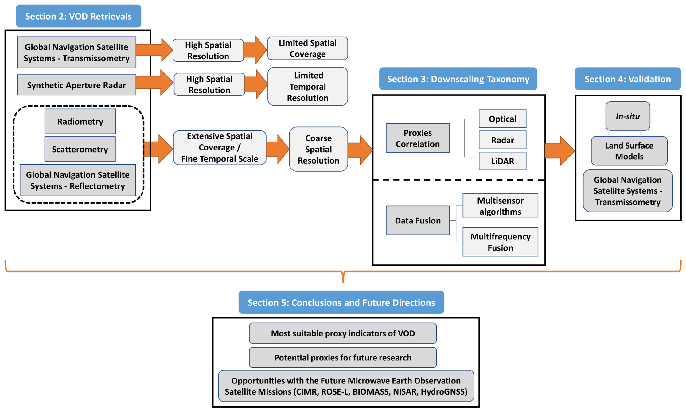
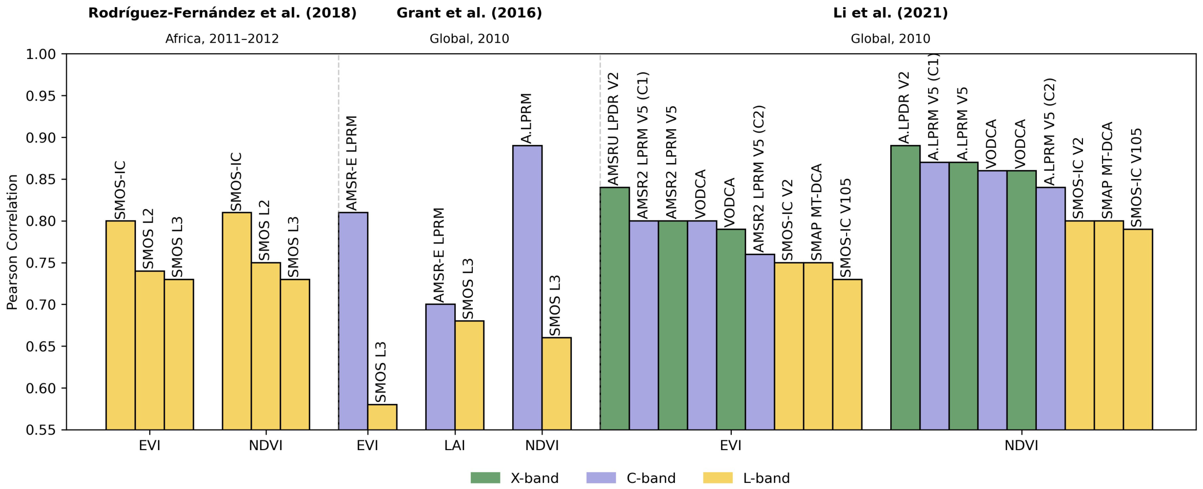
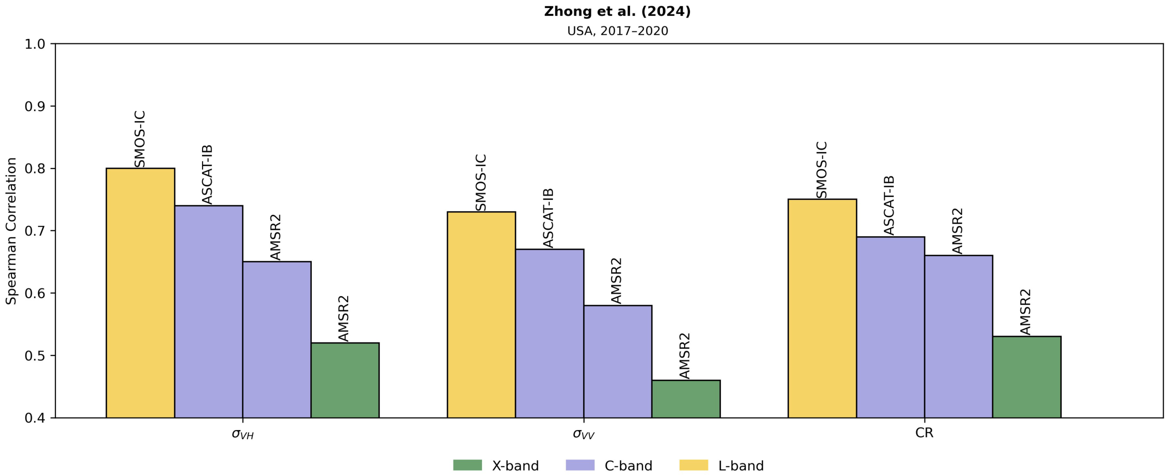
Microwave satellite vegetation parameters are widely used to monitor ecosystem spatiotemporal dynamics. Among these, vegetation optical depth (VOD) stands out as a critical microwave vegetation indicator, widely used for applications such as monitoring crop yield, estimating carbon stocks, and assessing risks threatening forests and their resilience to them. However, current VOD products are available at a coarse resolution, often around tens of kilometers, limiting their usefulness to only large-scale applications or those that do not need high spatial precision. Nevertheless, although extensive research has been conducted to improve the spatial resolution of several geophysical indicators, such as soil moisture, advances have been scarce for VOD. Here, we review the advances conducted to estimate VOD at medium-high spatial resolutions, overviewing the state of the art of different methods and their potentials and limitations. Basedon the available literature, we propose a taxonomy that classifies existing VOD downscaling approaches into proxy-based methods, which exploit the relationship between VOD and auxiliary variables, and data-fusion strategies that combine complementary microwave observations across sensors and frequencies. Also, we synthesize the suitability of different proxy variables according to the VOD frequency band, showing that while optical vegetation indices perform well for high-frequency VOD, the downscaling of low-frequency VOD benefits from the integration of complementary radar-derived proxies. Additionally, we examine the effectiveness and affordability of current validation methods and review the potential of emerging ones, such as GNSS technology and land surface models, to guarantee the reliable quality of future VOD downscaled products. Finally, we highlight the capabilities of future missions, particularly the upcoming CIMR multiresolution capability across frequency bands, which could considerably aid in obtaining VOD at better spatial scales.
Keywords: microwave remote sensing; vegetation optical depth; spatial resolution; downscaling algorithms microwave remote sensing; vegetation optical depth; spatial resolution; downscaling algorithms