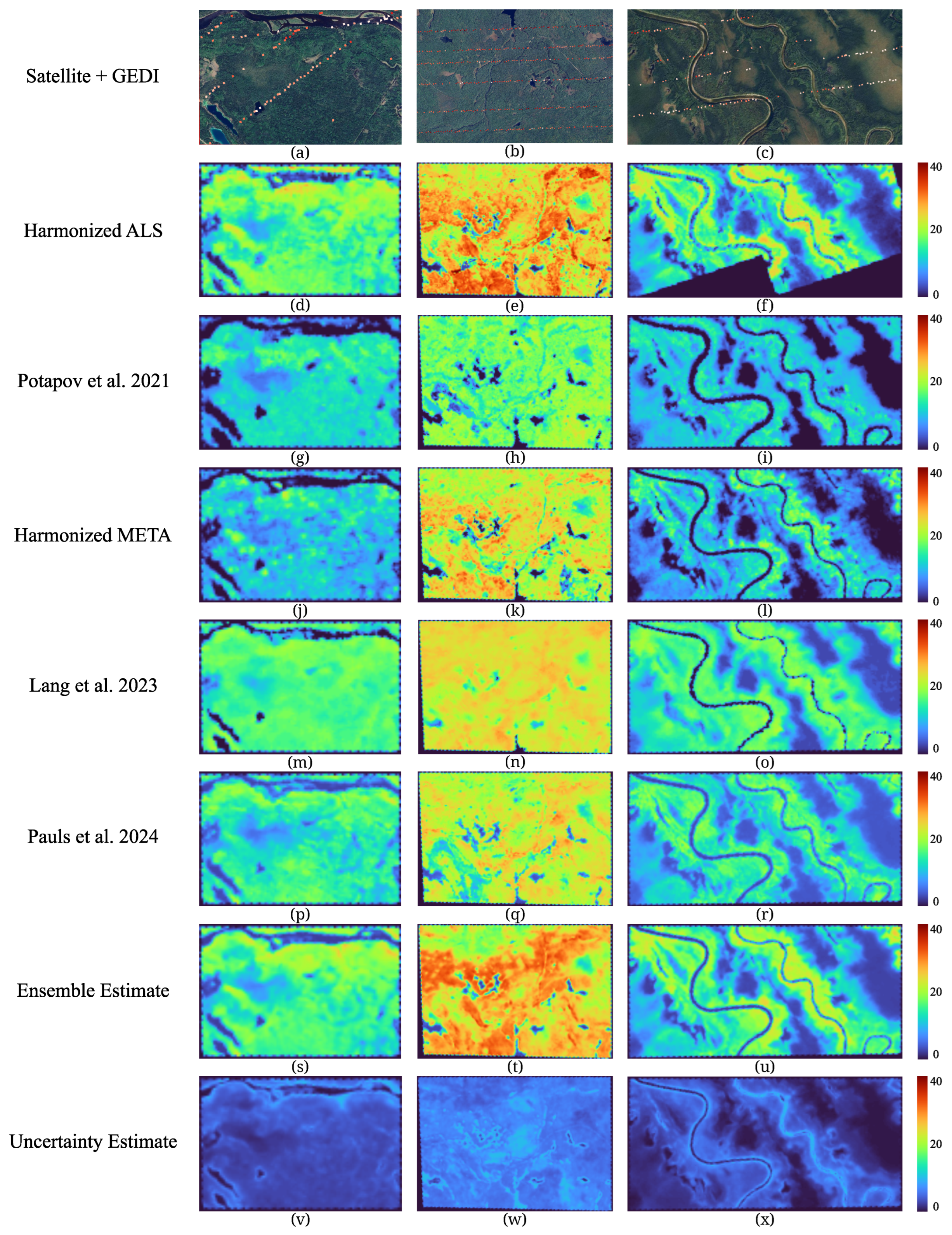
An Integrated Deep Learning Approach to Estimate Canopy Height and Uncertainty by Combining Seasonal Optical, SAR and Limited GEDI LiDAR Data over Ontario’s Managed Forests, Canada



Highlights
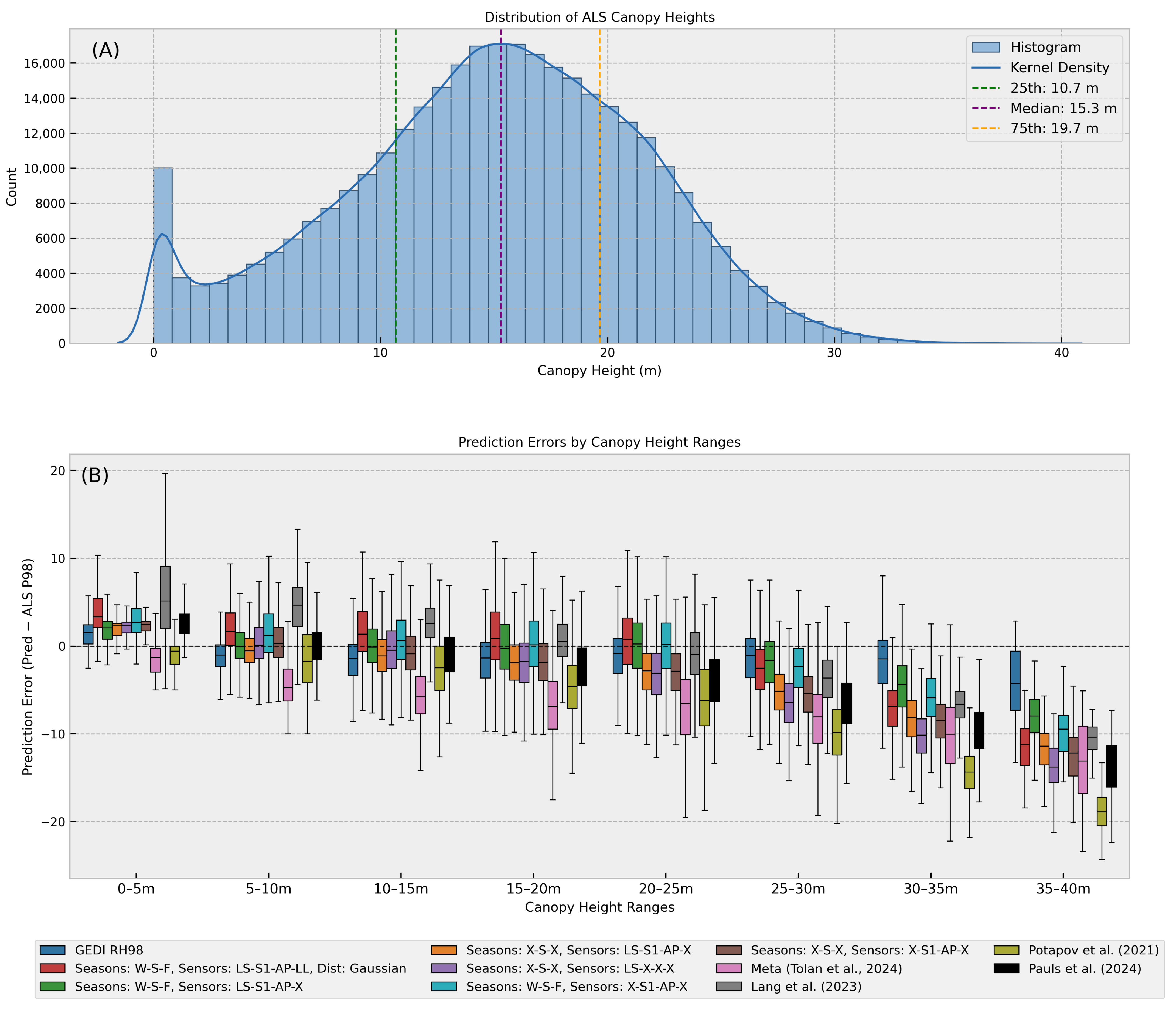
- The Laplace-loss ResUNet ensemble reduced canopy-height bias and achieved 3.65 m RMSE against independent airborne LiDAR.
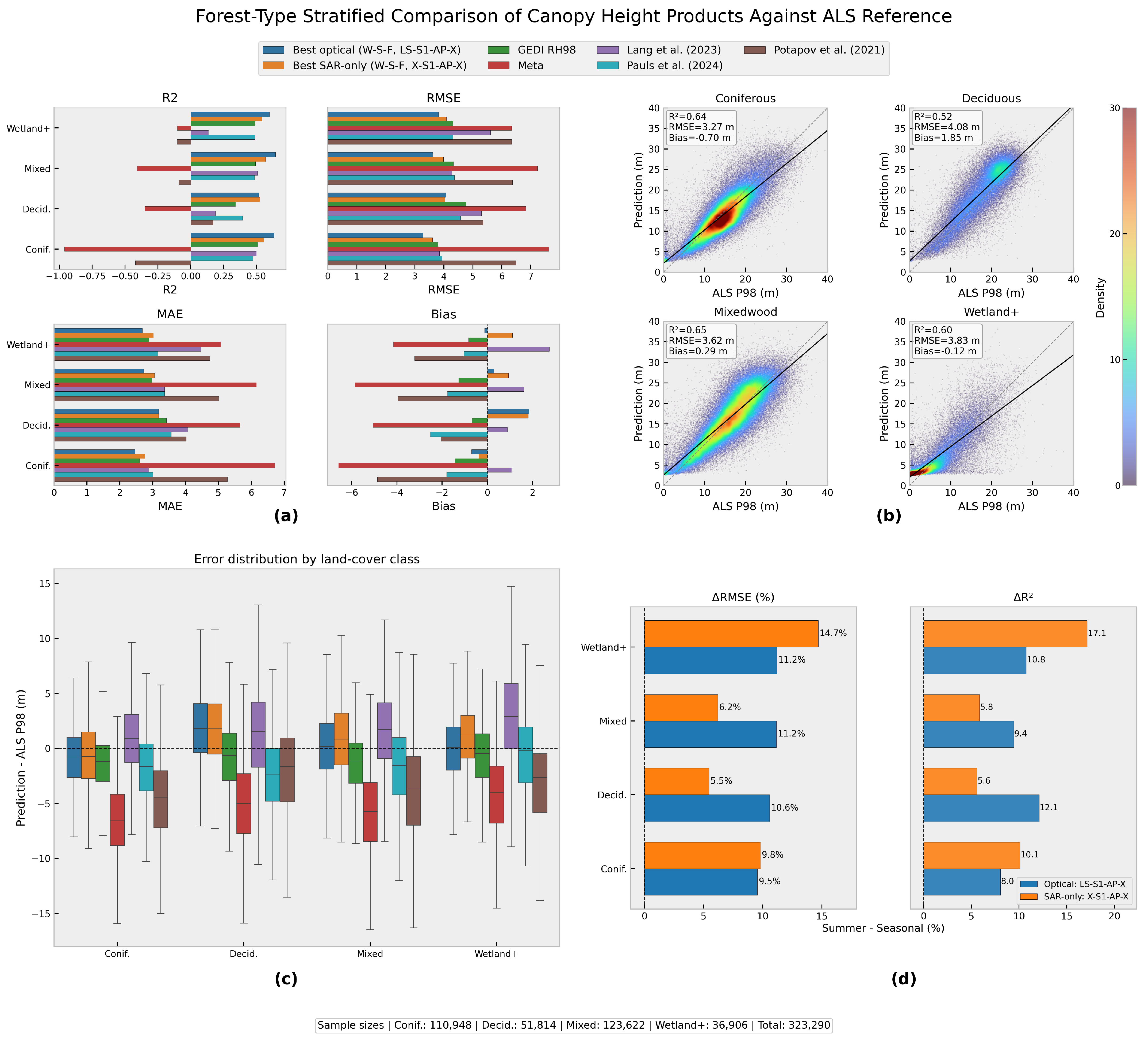
- Seasonal optical and SAR inputs improved canopy-height accuracy, while SAR-only models outperformed the tested global products across forest classes.
- More accurate, less biased canopy-height estimates can improve aboveground biomass and forest carbon-stock mapping.
- SAR-based canopy-height mapping can support biomass applications in cloud-prone northern forests where optical observations and LiDAR samples are limited.
Abstract
1. Introduction
2. Materials and Methods
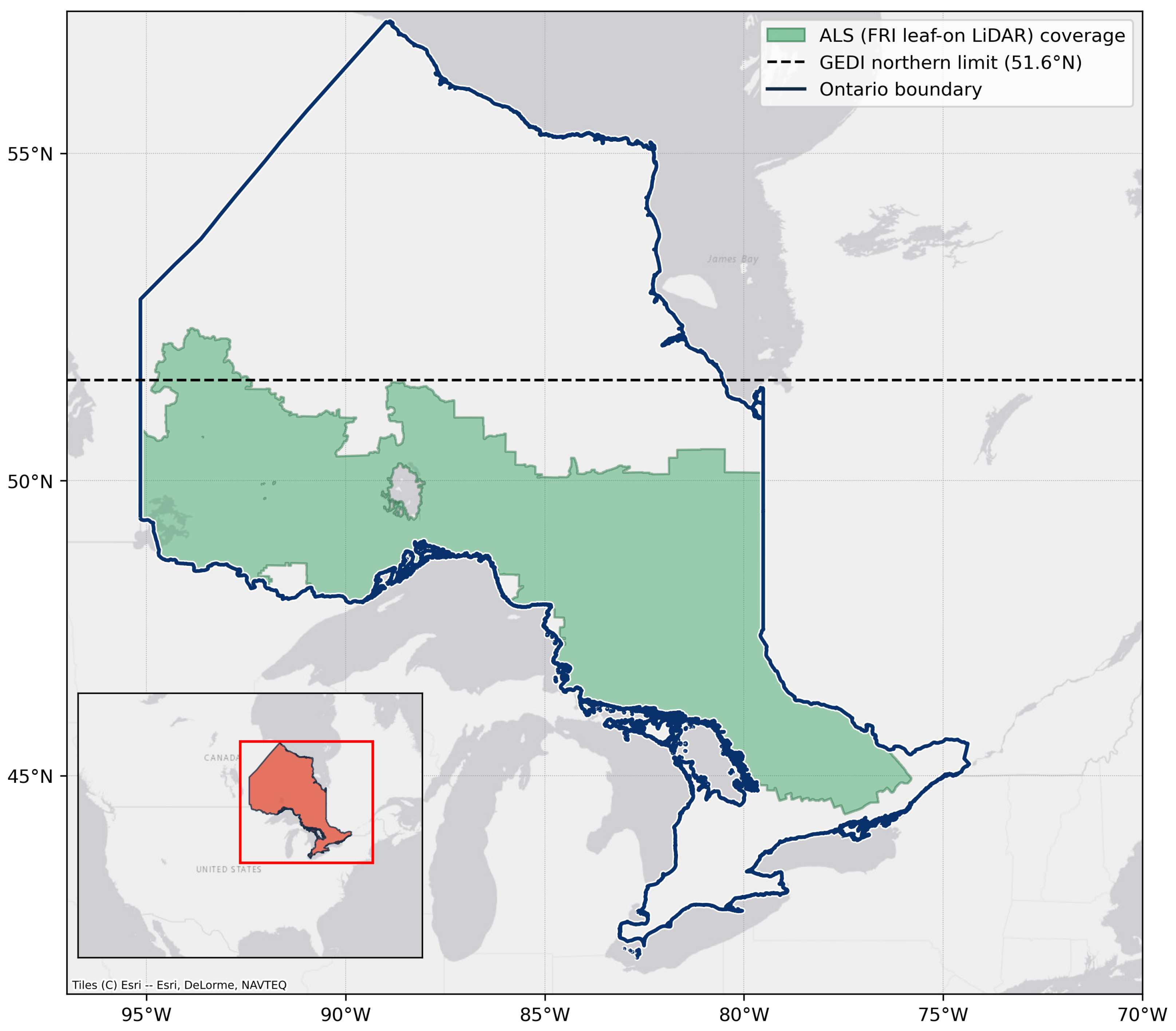
2.1. Study Area
2.2. Data
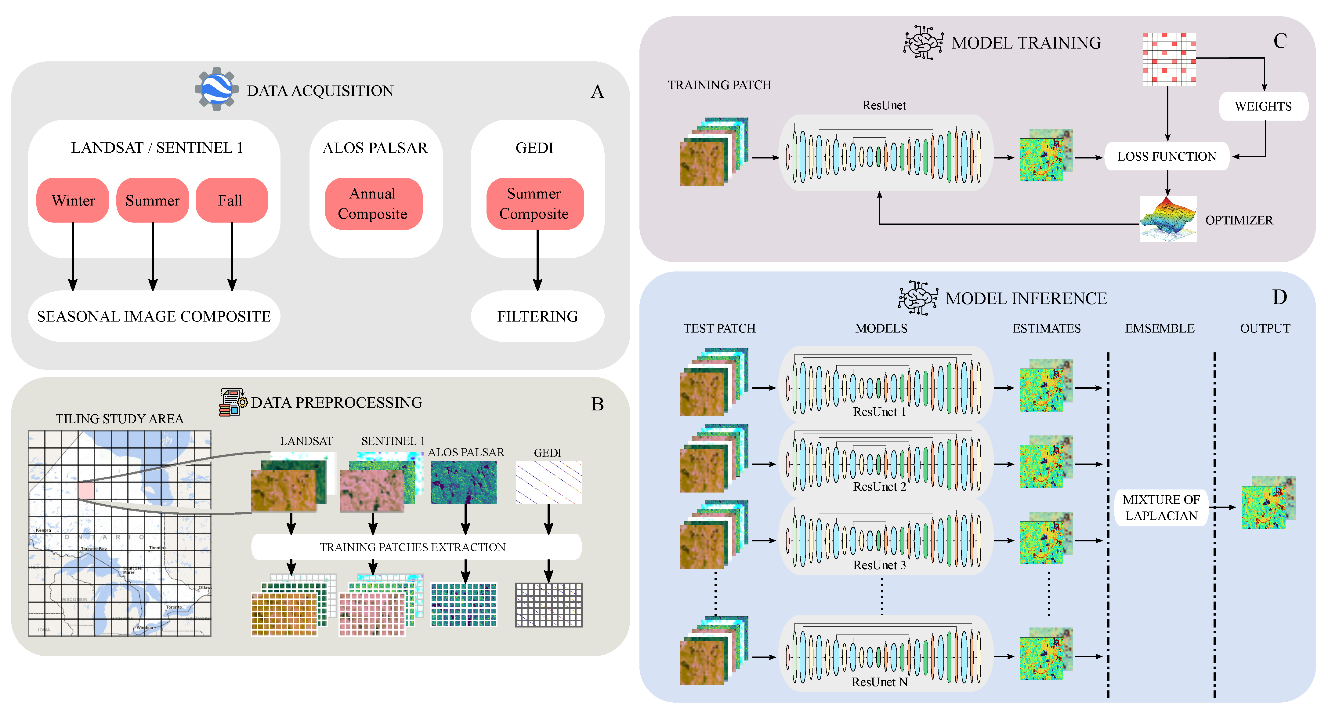
2.2.1. Satellite Data and Pre-Processing
| Algorithm 1 Seasonal Image Composite Algorithm (SICA) |
| Require: Y: Year; : Season; : Sensor; : Region of Interest; N: minimum number of observations at each pixel location; W: number of years back considered. ▹ initialise the target collection with an empty image collection while do ▹ count valid observations per pixel ▹ gather images matching Y, , , if is optical then ▹ mask out clouds, shadows, snow, etc. end if ▹ concatenate only at pixels with fewer than N valid observations ▹ update the target year end while ▹ compute the median image return |
2.2.2. Reference Airborne LiDAR (ALS) Data
2.2.3. Global Canopy-Height Products
2.2.4. Spatial Co-Location and Statistical Aggregation of GEDI with Reference Datasets
- Stage 1: Spatial Co-Location (Geometric Matching).
- Stage 2: Statistical Aggregation (Zonal Statistics).
2.3. Methodology
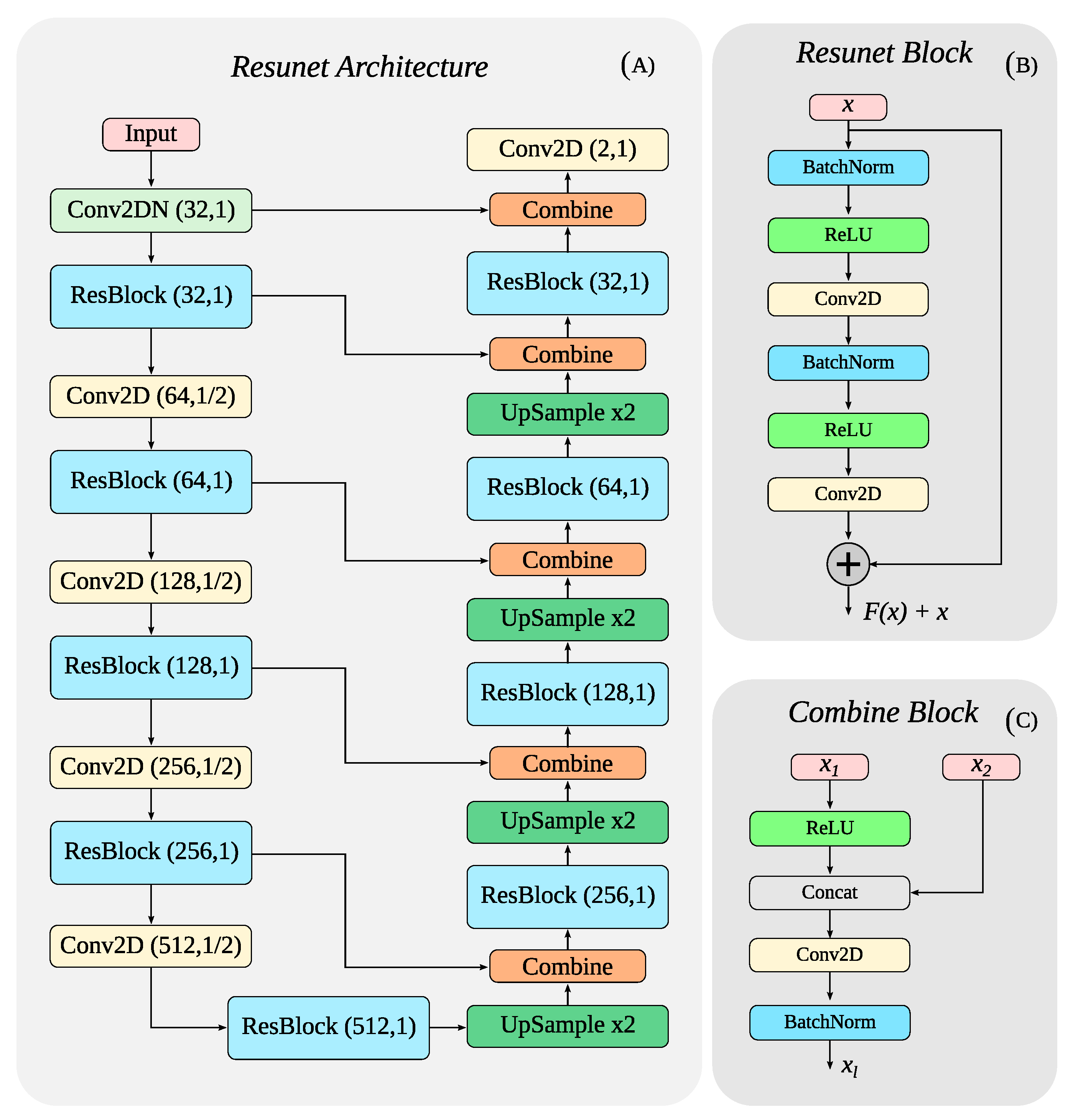
2.3.1. Neural Network Architecture
2.3.2. Model Setup and Parametrisation
2.3.3. Uncertainty Estimation and Calibration
2.4. Experimental Design
3. Results
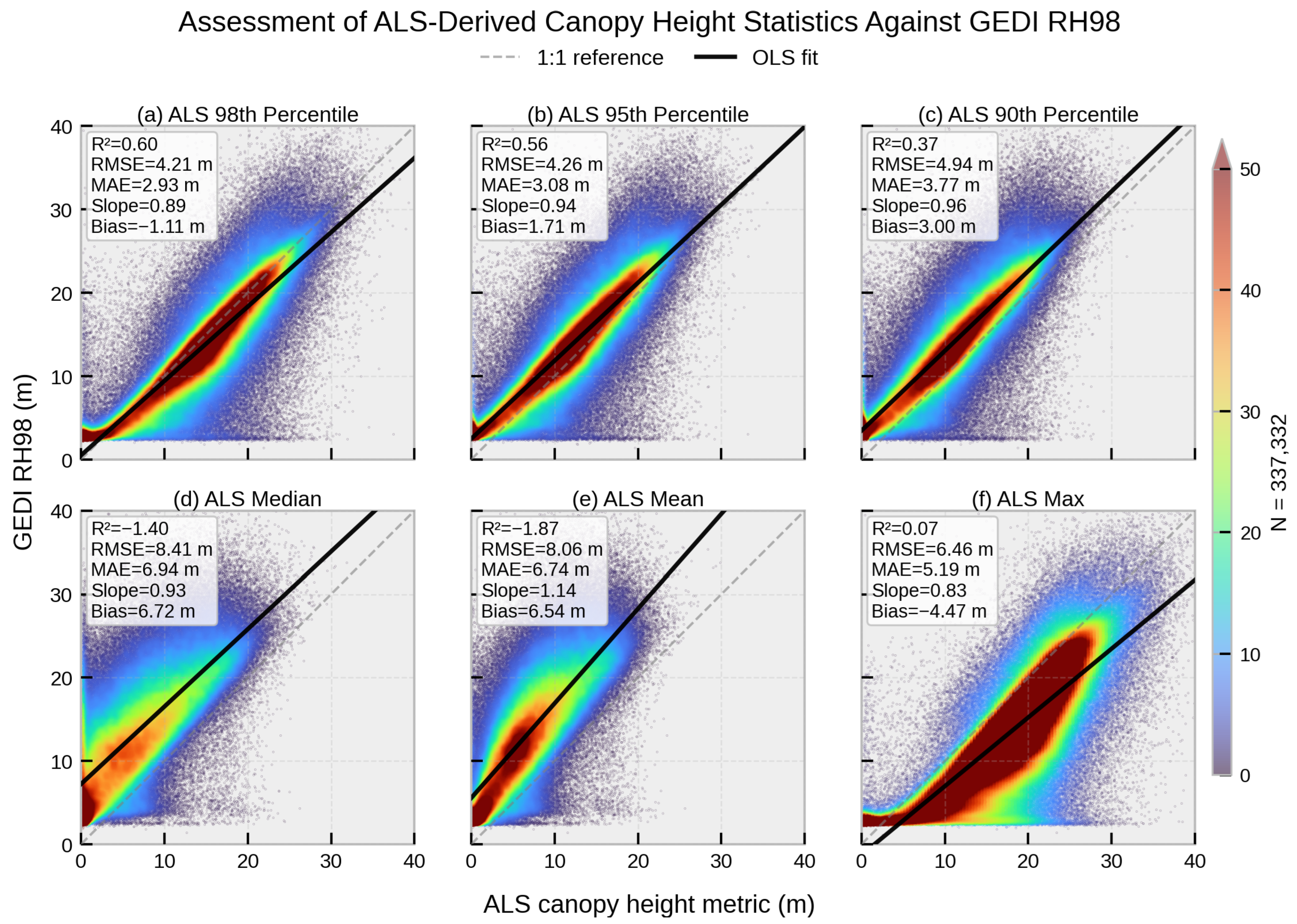
3.1. Agreement Between GEDI RH98 and ALS-Derived Metrics
3.2. Effect of the Laplace vs. Gaussian Negative Log-Likelihood Loss
3.3. Overall Canopy-Height Estimation Performance
3.4. Contribution of Seasonal Observations
3.5. Contribution of Multi-Sensor Fusion
3.6. Comparison with GEDI Observations and Global Canopy-Height Products
3.7. Prediction Error Along Canopy Heights
3.8. Uncertainty Analysis
3.9. Visual Analysis
3.10. Performance Across Forest Types
4. Discussion
4.1. Effect of the Laplace NLL Loss
4.2. Seasonal Information and Sensor Complementarity
4.3. SAR-Only Viability in Cloud-Prone Regions
4.4. Forest-Type-Specific Behaviour
4.5. Geographic Coordinates as Inputs
4.6. Performance of Global Products
4.7. Low-Canopy Bias and the Role of Anchor Samples
4.8. Uncertainty Maps as a Usable Confidence Layer
4.9. Limitations
5. Conclusions
Supplementary Materials
Author Contributions
Funding
Data Availability Statement
Acknowledgments
Conflicts of Interest
Abbreviations
| AGB | Aboveground Biomass |
| ALS | Airborne LiDAR |
| BAP | Best Available Pixel |
| CH | Canopy Height |
| CHM | Canopy-Height Model |
| CNN | Convolutional Neural Network |
| DL | Deep Learning |
| DSM | Digital Surface Model |
| DTM | Digital Terrain Model |
| FCN | Fully Convolutional Network |
| FRI | Forest Resources Inventory |
| GEDI | Global Ecosystem Dynamics Investigation |
| GEE | Google Earth Engine |
| ISS | International Space Station |
| KDE | Kernel Density Estimate |
| LDS | Label Distribution Smoothing |
| LiDAR | Light Detection and Ranging |
| NLL | Negative Log-Likelihood |
| RH98 | Relative Height 98th percentile |
| RMSE | Root Mean Square Error |
| SAR | Synthetic Aperture Radar |
| SICA | Seasonal Image Composite Algorithm |
| SPL | Single Photon LiDAR |
| UCE | Uncertainty Calibration Error |
| UCNN | Uncertainty Convolutional Neural Network |
References
- Asner, G.P.; Martin, R.E.; Carranza-Jiménez, L.; Sinca, F.; Tupayachi, R.; Anderson, C.B.; Martinez, P. Functional and biological diversity of foliar spectra in tree canopies throughout the Andes to Amazon region. New Phytol. 2014, 204, 127–139. [Google Scholar] [CrossRef] [Scilit] [PubMed]
- Mitchard, E.T.; Feldpausch, T.R.; Brienen, R.J.; Lopez-Gonzalez, G.; Monteagudo, A.; Baker, T.R.; Lewis, S.L.; Lloyd, J.; Quesada, C.A.; Gloor, M.; et al. Markedly divergent estimates of A mazon forest carbon density from ground plots and satellites. Glob. Ecol. Biogeogr. 2014, 23, 935–946. [Google Scholar] [CrossRef] [Scilit] [PubMed]
- Stovall, A.E.; Fatoyinbo, T.; Thomas, N.M.; Armston, J.; Ebanega, M.O.; Simard, M.; Trettin, C.; Zogo, R.V.O.; Aken, I.A.; Debina, M.; et al. Comprehensive comparison of airborne and spaceborne SAR and LiDAR estimates of forest structure in the tallest mangrove forest on earth. Sci. Remote Sens. 2021, 4, 100034. [Google Scholar] [CrossRef] [Scilit]
- Pan, Y.; Birdsey, R.A.; Phillips, O.L.; Houghton, R.A.; Fang, J.; Kauppi, P.E.; Keith, H.; Kurz, W.A.; Ito, A.; Lewis, S.L.; et al. The enduring world forest carbon sink. Nature 2024, 631, 563–569. [Google Scholar] [CrossRef] [Scilit] [PubMed]
- IPCC. Climate Change 2023: Synthesis Report. Contribution of Working Groups I, II and III to the Sixth Assessment Report of the Intergovernmental Panel on Climate Change; IPCC: Geneva, Switzerland, 2023. [Google Scholar] [CrossRef] [Scilit]
- Jucker, T.; Caspersen, J.; Chave, J.; Antin, C.; Barbier, N.; Bongers, F.; Dalponte, M.; van Ewijk, K.Y.; Forrester, D.I.; Haeni, M.; et al. Allometric equations for integrating remote sensing imagery into forest monitoring programmes. Glob. Change Biol. 2017, 23, 177–190. [Google Scholar] [CrossRef] [Scilit] [PubMed]
- Carreiras, J.M.; Quegan, S.; Le Toan, T.; Minh, D.H.T.; Saatchi, S.S.; Carvalhais, N.; Reichstein, M.; Scipal, K. Coverage of high biomass forests by the ESA BIOMASS mission under defense restrictions. Remote Sens. Environ. 2017, 196, 154–162. [Google Scholar] [CrossRef] [Scilit]
- Csillik, O.; Kumar, P.; Mascaro, J.; O’Shea, T.; Asner, G.P. Monitoring tropical forest carbon stocks and emissions using Planet satellite data. Sci. Rep. 2019, 9, 17831. [Google Scholar] [CrossRef] [Scilit] [PubMed]
- Qi, W.; Saarela, S.; Armston, J.; Ståhl, G.; Dubayah, R. Forest biomass estimation over three distinct forest types using TanDEM-X InSAR data and simulated GEDI lidar data. Remote Sens. Environ. 2019, 232, 111283. [Google Scholar] [CrossRef] [Scilit]
- Hentz, Â.M.; Silva, C.A.; Dalla Corte, A.P.; Netto, S.P.; Strager, M.P.; Klauberg, C. Estimating forest uniformity in Eucalyptus spp. and Pinus taeda L. stands using field measurements and structure from motion point clouds generated from unmanned aerial vehicle (UAV) data collection. For. Syst. 2018, 27, e005. [Google Scholar] [CrossRef] [Scilit]
- Silva, C.; Hudak, A.; Vierling, L.; Valbuena, R.; Cardil, A.; Mohan, M.; Almeida, D.; Broadbent, E.; Zambrano, A.; Wilkinson, B.; et al. Treetop: A Shiny-Based Application for Extracting Forest Information from LiDAR Data. Version 0.0. 3. Methods Ecol. Evol. 2022, 13, 1164–1176. [Google Scholar] [CrossRef] [Scilit]
- Stephenson, N.L.; Das, A.; Condit, R.; Russo, S.; Baker, P.; Beckman, N.G.; Coomes, D.; Lines, E.; Morris, W.; Rüger, N.; et al. Rate of tree carbon accumulation increases continuously with tree size. Nature 2014, 507, 90–93. [Google Scholar] [CrossRef] [Scilit] [PubMed]
- Wulder, M.A.; White, J.C.; Nelson, R.F.; Næsset, E.; Ørka, H.O.; Coops, N.C.; Hilker, T.; Bater, C.W.; Gobakken, T. Lidar sampling for large-area forest characterization: A review. Remote Sens. Environ. 2012, 121, 196–209. [Google Scholar] [CrossRef] [Scilit]
- Tompalski, P.; Coops, N.C.; White, J.C.; Goodbody, T.R.; Hennigar, C.R.; Wulder, M.A.; Socha, J.; Woods, M.E. Estimating changes in forest attributes and enhancing growth projections: A review of existing approaches and future directions using airborne 3D point cloud data. Curr. For. Rep. 2021, 7, 1–24. [Google Scholar] [CrossRef] [Scilit]
- Dubayah, R.; Blair, J.B.; Goetz, S.; Fatoyinbo, L.; Hansen, M.; Healey, S.; Hofton, M.; Hurtt, G.; Kellner, J.; Luthcke, S.; et al. The Global Ecosystem Dynamics Investigation: High-resolution laser ranging of the Earth’s forests and topography. Sci. Remote Sens. 2020, 1, 100002. [Google Scholar] [CrossRef] [Scilit]
- Liu, A.; Cheng, X.; Chen, Z. Performance evaluation of GEDI and ICESat-2 laser altimeter data for terrain and canopy height retrievals. Remote Sens. Environ. 2021, 264, 112571. [Google Scholar] [CrossRef] [Scilit]
- Qi, W.; Armston, J.; Choi, C.; Stovall, A.; Saarela, S.; Pardini, M.; Fatoyinbo, L.; Papathanassiou, K.; Pascual, A.; Dubayah, R. Mapping large-scale pantropical forest canopy height by integrating GEDI lidar and TanDEM-X InSAR data. Remote Sens. Environ. 2025, 318, 114534. [Google Scholar] [CrossRef] [Scilit]
- Krieger, G.; Moreira, A.; Fiedler, H.; Hajnsek, I.; Werner, M.; Younis, M.; Zink, M. TanDEM-X: A satellite formation for high-resolution SAR interferometry. IEEE Trans. Geosci. Remote Sens. 2007, 45, 3317–3341. [Google Scholar] [CrossRef] [Scilit]
- Silveira, E.M.; Radeloff, V.C.; Martinuzzi, S.; Pastur, G.J.M.; Bono, J.; Politi, N.; Lizarraga, L.; Rivera, L.O.; Ciuffoli, L.; Rosas, Y.M.; et al. Nationwide native forest structure maps for Argentina based on forest inventory data, SAR Sentinel-1 and vegetation metrics from Sentinel-2 imagery. Remote Sens. Environ. 2023, 285, 113391. [Google Scholar] [CrossRef] [Scilit]
- Sothe, C.; Gonsamo, A.; Lourenço, R.B.; Kurz, W.A.; Snider, J. Spatially continuous mapping of forest canopy height in Canada by combining GEDI and ICESat-2 with PALSAR and Sentinel. Remote Sens. 2022, 14, 5158. [Google Scholar] [CrossRef] [Scilit]
- Potapov, P.; Li, X.; Hernandez-Serna, A.; Tyukavina, A.; Hansen, M.C.; Kommareddy, A.; Pickens, A.; Turubanova, S.; Tang, H.; Silva, C.E.; et al. Mapping global forest canopy height through integration of GEDI and Landsat data. Remote Sens. Environ. 2021, 253, 112165. [Google Scholar] [CrossRef] [Scilit]
- Travers-Smith, H.; Coops, N.C.; Mulverhill, C.; Wulder, M.A.; Ignace, D.; Lantz, T.C. Mapping vegetation height and identifying the northern forest limit across Canada using ICESat-2, Landsat time series and topographic data. Remote Sens. Environ. 2024, 305, 114097. [Google Scholar] [CrossRef] [Scilit]
- Wright, M.N.; Dankowski, T.; Ziegler, A. Unbiased split variable selection for random survival forests using maximally selected rank statistics. Stat. Med. 2017, 36, 1272–1284. [Google Scholar] [CrossRef] [Scilit] [PubMed]
- Hengl, T.; Nussbaum, M.; Wright, M.N.; Heuvelink, G.B.; Gräler, B. Random forest as a generic framework for predictive modeling of spatial and spatio-temporal variables. PeerJ 2018, 6, e5518. [Google Scholar] [CrossRef] [Scilit] [PubMed]
- Fayad, I.; Ciais, P.; Schwartz, M.; Wigneron, J.P.; Baghdadi, N.; de Truchis, A.; d’Aspremont, A.; Frappart, F.; Saatchi, S.; Sean, E.; et al. Hy-TeC: A hybrid vision transformer model for high-resolution and large-scale mapping of canopy height. Remote Sens. Environ. 2024, 302, 113945. [Google Scholar] [CrossRef] [Scilit]
- Lang, N.; Kalischek, N.; Armston, J.; Schindler, K.; Dubayah, R.; Wegner, J.D. Global canopy height regression and uncertainty estimation from GEDI LIDAR waveforms with deep ensembles. Remote Sens. Environ. 2022, 268, 112760. [Google Scholar] [CrossRef] [Scilit]
- Lang, N.; Jetz, W.; Schindler, K.; Wegner, J.D. A high-resolution canopy height model of the Earth. Nat. Ecol. Evol. 2023, 7, 1778–1789. [Google Scholar] [CrossRef] [Scilit] [PubMed]
- Pauls, J.; Zimmer, M.; Kelly, U.M.; Schwartz, M.; Saatchi, S.; Ciais, P.; Pokutta, S.; Brandt, M.; Gieseke, F. Estimating canopy height at scale. arXiv 2024, arXiv:2406.01076. [Google Scholar]
- Liu, J.; Quan, Y.; Wang, B.; Shi, J.; Ming, L.; Li, M. Estimation of Forest Stock Volume Combining Airborne LiDAR Sampling Approaches with Multi-Sensor Imagery. Forests 2023, 14, 2453. [Google Scholar] [CrossRef] [Scilit]
- Tolan, J.; Yang, H.I.; Nosarzewski, B.; Couairon, G.; Vo, H.V.; Brandt, J.; Spore, J.; Majumdar, S.; Haziza, D.; Vamaraju, J.; et al. Very high resolution canopy height maps from RGB imagery using self-supervised vision transformer and convolutional decoder trained on aerial lidar. Remote Sens. Environ. 2024, 300, 113888. [Google Scholar] [CrossRef] [Scilit]
- Wagner, F.H.; Roberts, S.; Ritz, A.L.; Carter, G.; Dalagnol, R.; Favrichon, S.; Hirye, M.C.M.; Brandt, M.; Ciais, P.; Saatchi, S. Sub-meter tree height mapping of California using aerial images and LiDAR-informed U-Net model. Remote Sens. Environ. 2024, 305, 114099. [Google Scholar] [CrossRef] [Scilit]
- Barbier, N.; Couteron, P.; Proisy, C.; Malhi, Y.; Gastellu-Etchegorry, J.P. The variation of apparent crown size and canopy heterogeneity across lowland Amazonian forests. Glob. Ecol. Biogeogr. 2010, 19, 72–84. [Google Scholar] [CrossRef] [Scilit]
- Couteron, P.; Pelissier, R.; Nicolini, E.A.; Paget, D. Predicting tropical forest stand structure parameters from Fourier transform of very high-resolution remotely sensed canopy images. J. Appl. Ecol. 2005, 42, 1121–1128. [Google Scholar] [CrossRef] [Scilit]
- Ploton, P.; Pélissier, R.; Barbier, N.; Proisy, C.; Ramesh, B.R.; Couteron, P. Canopy texture analysis for large-scale assessments of tropical forest stand structure and biomass. In Treetops at Risk: Challenges of Global Canopy Ecology and Conservation; Lowman, M.D., Devy, S., Ganesh, T., Eds.; Springer: New York, NY, USA, 2013; pp. 237–245. [Google Scholar] [CrossRef] [Scilit]
- Lu, D.; Chen, Q.; Wang, G.; Moran, E.; Batistella, M.; Zhang, M.; Vaglio Laurin, G.; Saah, D. Aboveground forest biomass estimation with Landsat and LiDAR data and uncertainty analysis of the estimates. Int. J. For. Res. 2012, 2012, 436537. [Google Scholar] [CrossRef] [Scilit]
- Le Toan, T.; Quegan, S.; Davidson, M.; Balzter, H.; Paillou, P.; Papathanassiou, K.; Plummer, S.; Rocca, F.; Saatchi, S.; Shugart, H.; et al. The BIOMASS mission: Mapping global forest biomass to better understand the terrestrial carbon cycle. Remote Sens. Environ. 2011, 115, 2850–2860. [Google Scholar] [CrossRef] [Scilit]
- Duncanson, L.; Kellner, J.R.; Armston, J.; Dubayah, R.; Minor, D.M.; Hancock, S.; Healey, S.P.; Patterson, P.L.; Saarela, S.; Marselis, S.; et al. Aboveground biomass density models for NASA’s Global Ecosystem Dynamics Investigation (GEDI) lidar mission. Remote Sens. Environ. 2022, 270, 112845. [Google Scholar] [CrossRef] [Scilit]
- Commission for Environmental Cooperation (CEC). 2020 Land Cover of North America at 30 Meters; Ed. 1.0, Raster Digital Data [30 m]; North American Land Change Monitoring System (NALCMS): Montreal, QC, Canada; Canada Centre for Remote Sensing (CCRS): Ottawa, ON, Canada; U.S. Geological Survey (USGS): Reston, VA, USA; CONABIO: Mexico City, Mexico; CONAFOR: Zapopan, Mexico; INEGI: Aguascalientes, Mexico, 2023; Available online: http://www.cec.org/north-american-environmental-atlas/land-cover-30m-2020/ (accessed on 15 July 2026).
- Gorelick, N.; Hancher, M.; Dixon, M.; Ilyushchenko, S.; Thau, D.; Moore, R. Google Earth Engine: Planetary-scale geospatial analysis for everyone. Remote Sens. Environ. 2017, 202, 18–27. [Google Scholar] [CrossRef] [Scilit]
- Thompson, S.D.; Nelson, T.A.; White, J.C.; Wulder, M.A. Mapping dominant tree species over large forested areas using Landsat best-available-pixel image composites. Can. J. Remote Sens. 2015, 41, 203–218. [Google Scholar] [CrossRef] [Scilit]
- Mao, L.; Bater, C.W.; Stadt, J.J.; White, B.; Tompalski, P.; Coops, N.C.; Nielsen, S.E. Environmental landscape determinants of maximum forest canopy height of boreal forests. J. Plant Ecol. 2019, 12, 96–102. [Google Scholar] [CrossRef] [Scilit]
- Bilyk, A.; Pulkki, R.; Shahi, C.; Larocque, G.R. Development of the Ontario Forest Resources Inventory: A historical review. Can. J. For. Res. 2021, 51, 198–209. [Google Scholar] [CrossRef] [Scilit]
- Oquab, M.; Darcet, T.; Moutakanni, T.; Vo, H.; Szafraniec, M.; Khalidov, V.; Fernandez, P.; Haziza, D.; Massa, F.; El-Nouby, A.; et al. Dinov2: Learning robust visual features without supervision. arXiv 2023, arXiv:2304.07193. [Google Scholar] [CrossRef] [Scilit]
- Kutchartt, G.; Neuenschwander, A.; Hancock, S.; Hofton, M.; Blair, J.; Luthcke, S. Assessment of ranging and positioning accuracy of the GEDI laser altimeter on the International Space Station. Remote Sens. Environ. 2022, 274, 112963. [Google Scholar] [CrossRef] [Scilit]
- Long, J.; Shelhamer, E.; Darrell, T. Fully convolutional networks for semantic segmentation. In Proceedings of the IEEE Conference on Computer Vision and Pattern Recognition; IEEE: Piscataway, NJ, USA, 2015; pp. 3431–3440. [Google Scholar] [CrossRef] [Scilit]
- Diakogiannis, F.I.; Waldner, F.; Caccetta, P.; Wu, C. ResUNet-a: A deep learning framework for semantic segmentation of remotely sensed data. ISPRS J. Photogramm. Remote Sens. 2020, 162, 94–114. [Google Scholar] [CrossRef] [Scilit]
- Lakshminarayanan, B.; Pritzel, A.; Blundell, C. Simple and scalable predictive uncertainty estimation using deep ensembles. In Proceedings of the Advances in Neural Information Processing Systems (NeurIPS), Long Beach, CA, USA, 4–9 December 2017; Volume 30. [Google Scholar]
- Chen, L.C.; Papandreou, G.; Kokkinos, I.; Murphy, K.; Yuille, A.L. Deeplab: Semantic image segmentation with deep convolutional nets, atrous convolution, and fully connected crfs. IEEE Trans. Pattern Anal. Mach. Intell. 2017, 40, 834–848. [Google Scholar] [CrossRef] [Scilit] [PubMed]
- He, K.; Zhang, X.; Ren, S.; Sun, J. Identity mappings in deep residual networks. In Proceedings of the European Conference on Computer Vision; Springer: Berlin/Heidelberg, Germany, 2016; pp. 630–645. [Google Scholar]
- Ioffe, S. Batch normalization: Accelerating deep network training by reducing internal covariate shift. arXiv 2015, arXiv:1502.03167. [Google Scholar]
- Nair, D.S.; Hochgeschwender, N.; Olivares-Méndez, M.A. Maximum likelihood uncertainty estimation: Robustness to outliers. arXiv 2022, arXiv:2202.03870. [Google Scholar]
- Kotz, S.; Kozubowski, T.; Podgorski, K. The Laplace Distribution and Generalizations: A Revisit with Applications to Communications, Economics, Engineering, and Finance; Springer Science & Business Media: Berlin/Heidelberg, Germany, 2012. [Google Scholar] [CrossRef] [Scilit]
- Yang, Y.; Zha, K.; Chen, Y.; Wang, H.; Katabi, D. Delving into deep imbalanced regression. In Proceedings of the International Conference on Machine Learning; PMLR: Cambridge, MA, USA, 2021; pp. 11842–11851. [Google Scholar]
- Steininger, M.; Kobs, K.; Davidson, P.; Krause, A.; Hotho, A. Density-based weighting for imbalanced regression. Mach. Learn. 2021, 110, 2187–2211. [Google Scholar] [CrossRef] [Scilit]
- Lahssini, K.; Baghdadi, N.; Le Maire, G.; Fayad, I. Influence of GEDI acquisition and processing parameters on canopy height estimates over tropical forests. Remote Sens. 2022, 14, 6264. [Google Scholar] [CrossRef] [Scilit]
- Fayad, I.; Baghdadi, N.; Riedi, J. Quality assessment of acquired gedi waveforms: Case study over france, tunisia and french guiana. Remote Sens. 2021, 13, 3144. [Google Scholar] [CrossRef] [Scilit]
- Tang, H.; Stoker, J.; Luthcke, S.; Armston, J.; Lee, K.; Blair, B.; Hofton, M. Evaluating and mitigating the impact of systematic geolocation error on canopy height measurement performance of GEDI. Remote Sens. Environ. 2023, 291, 113571. [Google Scholar] [CrossRef] [Scilit]
- Laves, M.H.; Ihler, S.; Kortmann, K.P.; Ortmaier, T. Well-calibrated model uncertainty with temperature scaling for dropout variational inference. arXiv 2019, arXiv:1909.13550. [Google Scholar]
- Laves, M.H.; Ihler, S.; Fast, J.F.; Kahrs, L.A.; Ortmaier, T. Well-Calibrated Regression Uncertainty in Medical Imaging with Deep Learning. In Proceedings of the Third Conference on Medical Imaging with Deep Learning, Montreal, QC, Canada, 6–8 July 2020; Proceedings of Machine Learning Research; Arbel, T., Ben Ayed, I., de Bruijne, M., Descoteaux, M., Lombaert, H., Pal, C., Eds.; PMLR: Cambridge, MA, USA, 2020; Volume 121, pp. 393–412. [Google Scholar]
- Kuleshov, V.; Fenner, N.; Ermon, S. Accurate uncertainties for deep learning using calibrated regression. In Proceedings of the International Conference on Machine Learning; PMLR: Cambridge, MA, USA, 2018; pp. 2796–2804. [Google Scholar]
- Dawood, T.; Chen, C.; Sidhu, B.S.; Ruijsink, B.; Gould, J.; Porter, B.; Elliott, M.K.; Mehta, V.; Rinaldi, C.A.; Puyol-Antón, E.; et al. Uncertainty aware training to improve deep learning model calibration for classification of cardiac MR images. Med. Image Anal. 2023, 88, 102861. [Google Scholar] [CrossRef] [Scilit] [PubMed]
- Zhang, H.; Zhang, Y.; Yu, Y.; Madeka, D.; Foster, D.; Xing, E.; Lakkaraju, H.; Kakade, S. A Study on the Calibration of In-context Learning. In Proceedings of the 2024 Conference of the North American Chapter of the Association for Computational Linguistics: Human Language Technologies; Duh, K., Gomez, H., Bethard, S., Eds.; Association for Computational Linguistics (ACL): Mexico City, Mexico, 2024; Volume 1: Long Papers, pp. 6118–6136. [Google Scholar] [CrossRef] [Scilit]
- Platt, J. Probabilistic outputs for support vector machines and comparisons to regularized likelihood methods. Adv. Large Margin Classif. 1999, 10, 61–74. [Google Scholar]
- Réjou-Méchain, M.; Muller-Landau, H.C.; Detto, M.; Thomas, S.C.; Le Toan, T.; Saatchi, S.S.; Barreto-Silva, J.S.; Bourg, N.A.; Bunyavejchewin, S.; Butt, N.; et al. Local spatial structure of forest biomass and its consequences for remote sensing of carbon stocks. Biogeosciences 2014, 11, 6827–6840. [Google Scholar] [CrossRef] [Scilit]
- Mascaro, J.; Detto, M.; Asner, G.P.; Muller-Landau, H.C. Evaluating uncertainty in mapping forest carbon with airborne LiDAR. Remote Sens. Environ. 2011, 115, 3770–3774. [Google Scholar] [CrossRef] [Scilit]
- Ploton, P.; Mortier, F.; Réjou-Méchain, M.; Barbier, N.; Piber, A.; Rossi, V.; Dormann, C.F.; Cornu, G.; Viennois, G.; Bayol, N.; et al. Spatial validation reveals poor predictive performance of large-scale ecological mapping models. Nat. Commun. 2020, 11, 4540. [Google Scholar] [CrossRef] [Scilit] [PubMed]
- Roberts, D.R.; Bahn, V.; Ciuti, S.; Boyce, M.S.; Elith, J.; Guillera-Arroita, G.; Hauenstein, S.; Lahoz-Monfort, J.J.; Schröder, B.; Thuiller, W.; et al. Cross-validation strategies for data with temporal, spatial, hierarchical, or phylogenetic structure. Ecography 2017, 40, 913–929. [Google Scholar] [CrossRef] [Scilit]
- Chan, T.F.; Golub, G.H.; LeVeque, R.J. Algorithms for computing the sample variance: Analysis and recommendations. Am. Stat. 1983, 37, 242–247. [Google Scholar] [CrossRef] [Scilit]
- Pedregosa, F.; Varoquaux, G.; Gramfort, A.; Michel, V.; Thirion, B.; Grisel, O.; Blondel, M.; Prettenhofer, P.; Weiss, R.; Dubourg, V.; et al. Scikit-learn: Machine learning in Python. J. Mach. Learn. Res. 2011, 12, 2825–2830. [Google Scholar]
- Huang, L.; Qin, J.; Zhou, Y.; Zhu, F.; Liu, L.; Shao, L. Normalization techniques in training dnns: Methodology, analysis and application. IEEE Trans. Pattern Anal. Mach. Intell. 2023, 45, 10173–10196. [Google Scholar] [CrossRef] [Scilit] [PubMed]
- Abadi, M.; Agarwal, A.; Barham, P.; Brevdo, E.; Chen, Z.; Citro, C.; Corrado, G.S.; Davis, A.; Dean, J.; Devin, M.; et al. TensorFlow: Large-Scale Machine Learning on Heterogeneous Systems. 2015. Available online: https://www.tensorflow.org (accessed on 15 July 2026).
- Kingma, D.P.; Ba, J. Adam: A method for stochastic optimization. arXiv 2014, arXiv:1412.6980. [Google Scholar] [CrossRef] [Scilit]
- Loshchilov, I.; Hutter, F. Sgdr: Stochastic gradient descent with warm restarts. arXiv 2016, arXiv:1608.03983. [Google Scholar] [CrossRef] [Scilit]
- Branco, P.; Torgo, L.; Ribeiro, R.P. A survey of predictive modeling on imbalanced domains. ACM Comput. Surv. 2016, 49, 31. [Google Scholar] [CrossRef] [Scilit]
- Ribeiro, R.P.; Moniz, N. Imbalanced regression and extreme value prediction. Mach. Learn. 2020, 109, 1803–1835. [Google Scholar] [CrossRef] [Scilit]
- Chen, J.M.; Liu, J.; Leblanc, S.G.; Lacaze, R.; Roujean, J.L. Multi-angular optical remote sensing for assessing vegetation structure and carbon absorption. Remote Sens. Environ. 2003, 84, 516–525. [Google Scholar] [CrossRef] [Scilit]
- Yan, X.; Li, J.; Smith, A.R.; Yang, D.; Ma, T.; Su, Y.; Shao, J. Evaluation of machine learning methods and multi-source remote sensing data combinations to construct forest above-ground biomass models. Int. J. Digit. Earth 2023, 16, 4471–4491. [Google Scholar] [CrossRef] [Scilit]
- Ohki, M.; Motohka, T.; Kankaku, Y.; Miura, S.H.; Tadono, T.; Arikawa, Y. Advanced Land Observing Satellite-4: Mission Concepts and Technical Overview: Pioneering a new era of L-band SAR. IEEE Geosci. Remote Sens. Mag. 2025, 13, 35–40. [Google Scholar] [CrossRef] [Scilit]
- Kellogg, K.; Hoffman, P.; Standley, S.; Shaffer, S.; Rosen, P.; Edelstein, W.; Dunn, C.; Baker, C.; Barela, P.; Shen, Y.; et al. NASA-ISRO synthetic aperture radar (NISAR) mission. In Proceedings of the 2020 IEEE Aerospace Conference; IEEE: Piscataway, NJ, USA, 2020; pp. 1–21. [Google Scholar]
- European Space Agency (ESA). Introducing BIOMASS; European Space Agency (ESA): Paris, France, 2023. [Google Scholar]
- Sahour, H.; Kemink, K.M.; O’Connell, J. Integrating SAR and Optical Remote Sensing for Conservation-Targeted Wetlands Mapping. Remote Sens. 2022, 14, 159. [Google Scholar] [CrossRef] [Scilit]
- Adam, M.; Urbazaev, M.; Dubois, C.; Schmullius, C. Accuracy assessment of GEDI terrain elevation and canopy height estimates in European temperate forests: Influence of environmental and acquisition parameters. Remote Sens. 2020, 12, 3948. [Google Scholar] [CrossRef] [Scilit]
- Matasci, G.; Coops, N.C.; Williams, D.A.; Page, N. Mapping tree canopies in urban environments using airborne laser scanning (ALS): A Vancouver case study. For. Ecosyst. 2018, 5, 31. [Google Scholar] [CrossRef] [Scilit]
- Min, W.; Chen, Y.; Huang, W.; Wilson, J.P.; Tang, H.; Guo, M.; Xu, R. Incorporating of spatial effects in forest canopy height mapping using airborne, spaceborne lidar and spatial continuous remote sensing data. Int. J. Appl. Earth Obs. Geoinf. 2024, 133, 104123. [Google Scholar] [CrossRef] [Scilit]
- Shen, H.; Wang, Y.; Guan, X.; Huang, W.; Chen, J.; Lin, D.; Gan, W. A spatiotemporal constrained machine learning method for OCO-2 solar-induced chlorophyll fluorescence (SIF) reconstruction. IEEE Trans. Geosci. Remote Sens. 2022, 60, 4413817. [Google Scholar] [CrossRef] [Scilit]
- Feng, Z.; Jaffer, S.; Knezevic, J.; Sormunen, S.; Young, R.; Lisaius, M.C.; Immitzer, M.; Ball, J.; Atzberger, C.; Coomes, D.A.; et al. TESSERA: Temporal Embeddings of Surface Spectra for Earth Representation and Analysis. In Proceedings of the IEEE/CVF Conference on Computer Vision and Pattern Recognition (CVPR); IEEE: Piscataway, NJ, USA, 2026; pp. 1–11. [Google Scholar]
- Friedman, J.H. Greedy function approximation: A gradient boosting machine. Ann. Stat. 2001, 29, 1189–1232. [Google Scholar] [CrossRef] [Scilit]
- Meinshausen, N. Quantile Regression Forests. J. Mach. Learn. Res. 2006, 7, 983–999. [Google Scholar]
- Pal, M. Random forest classifier for remote sensing classification. Int. J. Remote Sens. 2005, 26, 217–222. [Google Scholar] [CrossRef] [Scilit]
- Dhargay, S.; Lyell, C.S.; Brown, T.P.; Inbar, A.; Sheridan, G.J.; Lane, P.N.J. Performance of GEDI space-borne lidar for quantifying structural variation in the temperate forests of south-eastern Australia. Remote Sens. 2022, 14, 3615. [Google Scholar] [CrossRef] [Scilit]
- Moudrý, V.; Gdullová, K.; Holešinský, T.; Wild, J.; Kopecký, M.; Lánský, D.; Adámek, M. How to Find Accurate Terrain and Canopy Height GEDI Footprints in Temperate Forests and Grasslands? Earth Space Sci. 2024, 11, e2024EA003709. [Google Scholar] [CrossRef] [Scilit]
- Schlund, M.; Magdon, P.; Eaton, B.; Aumann, C.; Erasmi, S. Canopy height estimation with TanDEM-X in temperate and boreal forests. Int. J. Appl. Earth Obs. Geoinf. 2019, 82, 101904. [Google Scholar] [CrossRef] [Scilit]
- Schlund, S.; Kostolani, D. Towards designing adaptive and personalized work systems in manufacturing. In Digitization of the Work Environment for Sustainable Production; GITO mbH Verlag: Berlin, Germany, 2022; p. 81. [Google Scholar] [CrossRef] [Scilit]
- Eggleston, H.S.; Buendia, L.; Miwa, K.; Ngara, T.; Tanabe, K. (Eds.) 2006 IPCC Guidelines for National Greenhouse Gas Inventories. Volume 4: Agriculture, Forestry and Other Land Use (AFOLU); Institute for Global Environmental Strategies (IGES): Hayama, Japan, 2006; Volume 4. [Google Scholar]
- FAO. Global Forest Resources Assessment 2020: Main Report; Food and Agriculture Organization of the United Nations (FAO): Rome, Italy, 2020. [Google Scholar] [CrossRef] [Scilit]
- McFeeters, S.K. The use of the Normalized Difference Water Index (NDWI) in the delineation of open water features. Int. J. Remote Sens. 1996, 17, 1425–1432. [Google Scholar] [CrossRef] [Scilit]
- Xu, H. Modification of normalised difference water index (NDWI) to enhance open water features in remotely sensed imagery. Int. J. Remote Sens. 2006, 27, 3025–3033. [Google Scholar] [CrossRef] [Scilit]
- Zanaga, D.; Van De Kerchove, R.; De Keersmaecker, W.; Souverijns, N.; Brockmann, C.; Quast, R.; Wevers, J.; Grosu, A.; Paccini, A.; Vergnaud, S.; et al. ESA WorldCover 10 m 2020 v100. 2022. Available online: https://zenodo.org/records/5571936 (accessed on 15 July 2026).
- Valavi, R.; Elith, J.; Lahoz-Monfort, J.J.; Guillera-Arroita, G. blockCV: An R package for generating spatially or environmentally separated folds for k-fold cross-validation of species distribution models. Methods Ecol. Evol. 2019, 10, 225–232. [Google Scholar] [CrossRef] [Scilit]






| Features | Details |
|---|---|
| Landsat 7 & 8 | Type: Optical (multispectral) |
| Features: Blue, Green, Red, NIR, SWIR1 | |
| Temporal aggregation: Winter, Summer, Fall (3 seasons) | |
| Covariates: 5 per season (15 total) | |
| Notes: Standardised across sensors (Tier 1, SR) | |
| Sentinel-1 | Type: C-band SAR |
| Features: VV, VH polarisation | |
| Temporal aggregation: Winter, Summer, Fall (3 seasons) | |
| Covariates: 2 per season (6 total) | |
| Notes: Interferometric Wide swath, ascending pass | |
| ALOS-PALSAR-2 | Type: L-band SAR |
| Features: HH, HV polarisation | |
| Temporal aggregation: Annual composite | |
| Covariates: 2 total | |
| Notes: 1-year composite (2019–2020) | |
| Location | Type: Spatial features |
| Features: lat, | |
| Temporal aggregation: Static | |
| Covariates: 3 total (following [27] encoding) | |
| Total | 26 covariates |
| Product | Input Data | Target | Native Resolution |
|---|---|---|---|
| Meta [30] | Commercial HR imagery | ALS-derived canopy top | 1 m |
| Lang et al. [27] | Sentinel-2 | GEDI canopy height | 10 m |
| Potapov et al. [21] | Multi-temporal Landsat-8 | GEDI RH95 | 30 m |
| Pauls et al. [28] | Sentinel-1 + Sentinel-2 | GEDI (shift-tolerant) | 10 m |
| Token | Meaning |
|---|---|
| Temporal pattern (3 tokens) | |
| W | Winter composite included (Jan–Mar) |
| S | Summer composite included (Jun–Aug) |
| F | Fall composite included (Sep–Nov) |
| Sensor/geographic pattern (4 tokens) | |
| LS | Landsat (B, G, R, NIR, SWIR1) included |
| S1 | Sentinel-1 (VV, VH) included |
| AP | ALOS-PALSAR-2 (HH, HV) included |
| LL | Latitude/longitude coordinates included |
| X | Corresponding component omitted |
| Configuration | RMSE (m) | MAE (m) | Bias (m) | Slope | |
|---|---|---|---|---|---|
| All-season optical-containing (W–S–F) | |||||
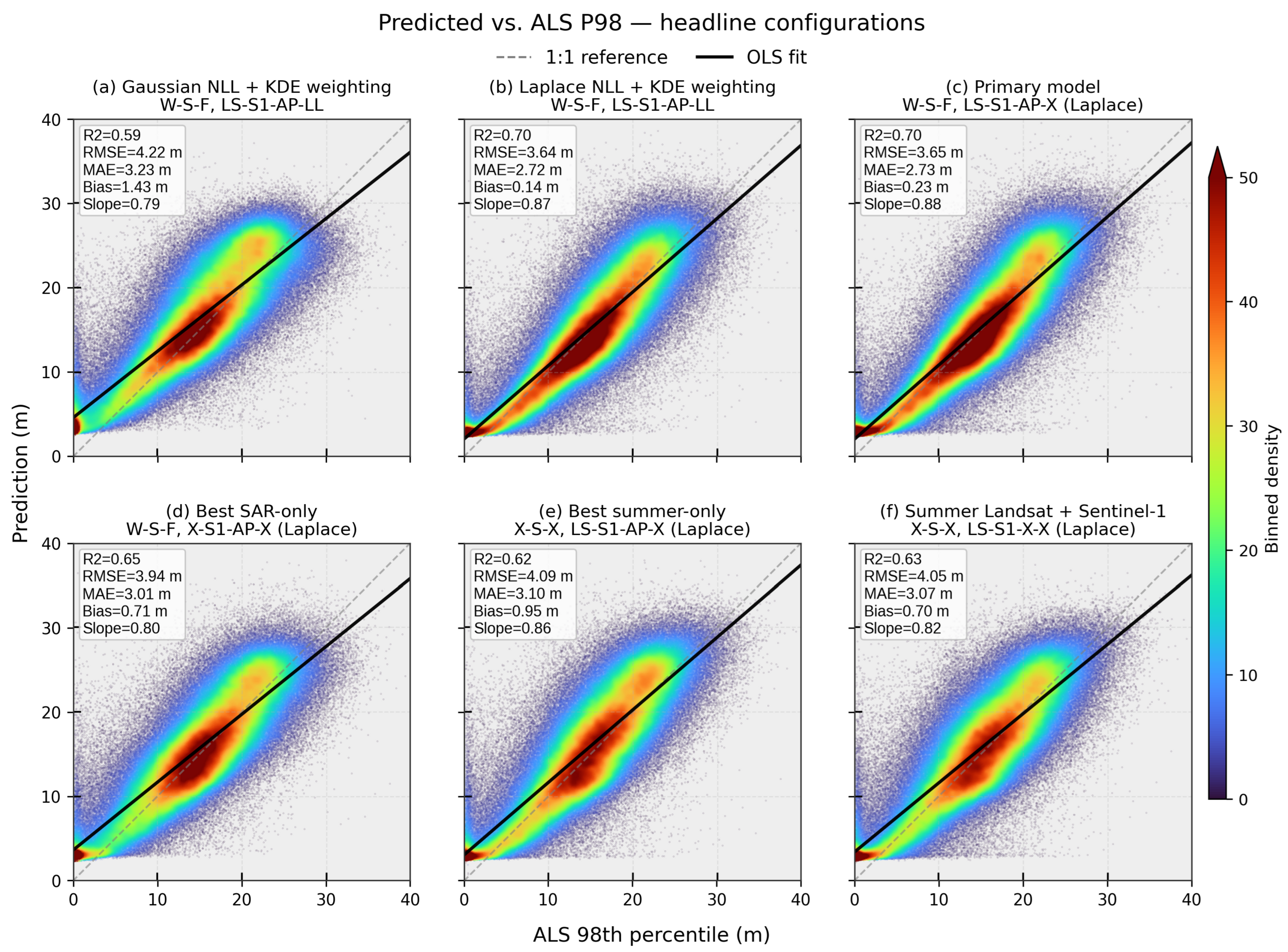
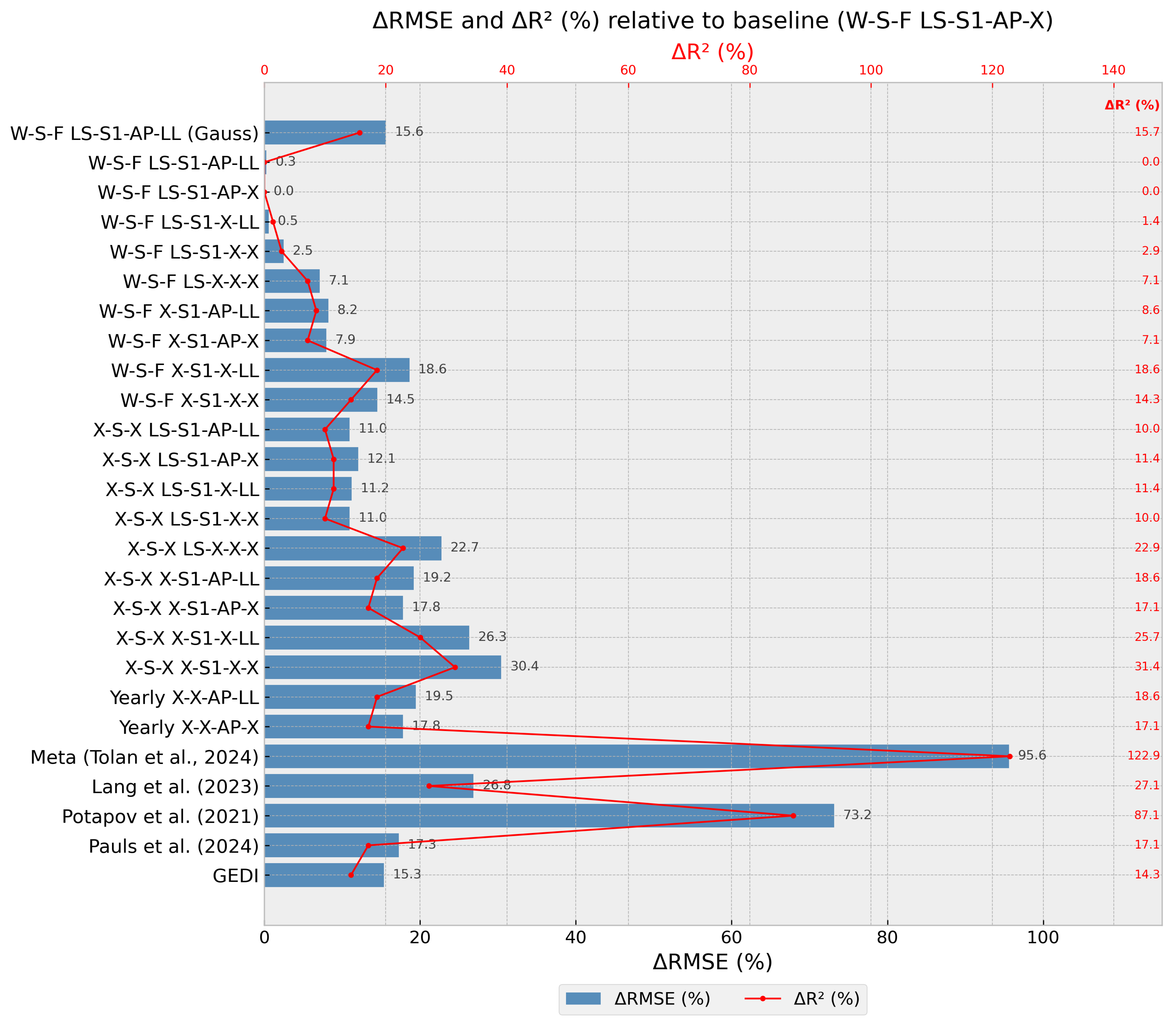
| W–S–F LS–S1–AP–X a | 0.70 | 3.65 | 2.73 | 0.23 | 0.88 |
| W–S–F LS–S1–AP–LL | 0.70 | 3.64 | 2.72 | 0.14 | 0.87 |
| W–S–F LS–S1–X–LL | 0.69 | 3.67 | 2.76 | 0.07 | 0.83 |
| W–S–F LS–S1–X–X | 0.68 | 3.74 | 2.81 | 0.27 | 0.87 |
| W–S–F LS–X–X–X | 0.65 | 3.91 | 2.98 | 0.42 | 0.84 |
| W–S–F LS–S1–AP–LL (Gaussian) | 0.59 | 4.22 | 3.23 | 1.43 | 0.79 |
| All-season SAR-only (W–S–F) | |||||
| W–S–F X–S1–AP–X | 0.65 | 3.94 | 3.01 | 0.71 | 0.80 |
| W–S–F X–S1–AP–LL | 0.64 | 3.95 | 3.01 | 0.81 | 0.79 |
| W–S–F X–S1–X–X | 0.60 | 4.18 | 3.20 | 0.89 | 0.77 |
| W–S–F X–S1–X–LL | 0.57 | 4.33 | 3.33 | 1.17 | 0.77 |
| Yearly X–X–AP–X b | 0.58 | 4.30 | 3.37 | −1.05 | 0.61 |
| Yearly X–X–AP–LL b | 0.57 | 4.36 | 3.42 | −1.40 | 0.59 |
| Summer-only (X–S–X) | |||||
| X–S–X LS–S1–AP–LL | 0.63 | 4.05 | 3.06 | 0.88 | 0.84 |
| X–S–X LS–S1–AP–X | 0.62 | 4.09 | 3.10 | 0.95 | 0.86 |
| X–S–X LS–S1–X–LL | 0.62 | 4.06 | 3.07 | 0.69 | 0.80 |
| X–S–X LS–S1–X–X | 0.63 | 4.05 | 3.07 | 0.70 | 0.82 |
| X–S–X LS–X–X–X | 0.54 | 4.48 | 3.44 | 0.88 | 0.75 |
| X–S–X X–S1–AP–X | 0.58 | 4.30 | 3.29 | 1.27 | 0.80 |
| X–S–X X–S1–AP–LL | 0.57 | 4.35 | 3.31 | 1.28 | 0.79 |
| X–S–X X–S1–X–LL | 0.52 | 4.61 | 3.52 | 1.12 | 0.68 |
| X–S–X X–S1–X–X | 0.48 | 4.76 | 3.62 | 1.66 | 0.73 |
| Reference and global products | |||||
| GEDI RH98 | 0.60 | 4.21 | 2.93 | −1.11 | 0.89 |
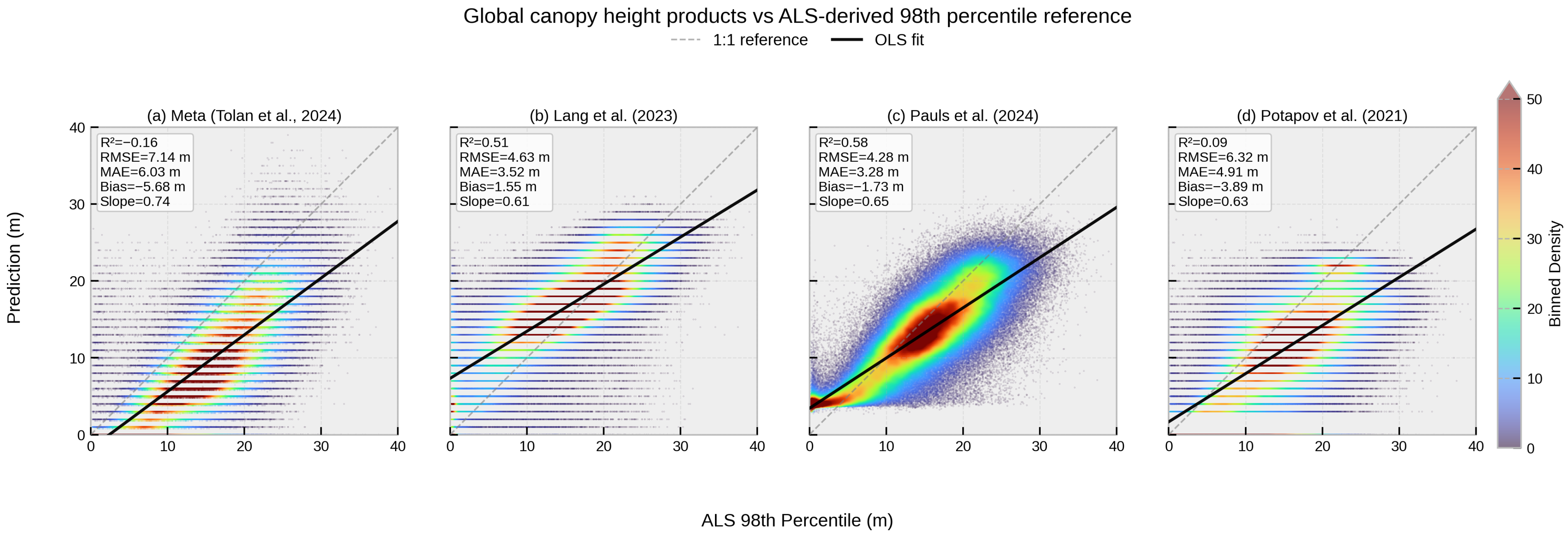
| Pauls et al. [28] | 0.58 | 4.28 | 3.28 | −1.73 | 0.65 |
| Lang et al. [27] | 0.51 | 4.63 | 3.52 | 1.55 | 0.61 |
| Potapov et al. [21] | 0.09 | 6.32 | 4.91 | −3.89 | 0.63 |
| Meta [30] | −0.16 | 7.14 | 6.03 | −5.68 | 0.74 |
Disclaimer/Publisher’s Note: The statements, opinions and data contained in all publications are solely those of the individual author(s) and contributor(s) and not of MDPI and/or the editor(s). MDPI and/or the editor(s) disclaim responsibility for any injury to people or property resulting from any ideas, methods, instructions or products referred to in the content. |
© 2026 by the authors. Licensee MDPI, Basel, Switzerland. This article is an open access article distributed under the terms and conditions of the Creative Commons Attribution (CC BY) license.
Share and Cite
Bermudez, J.; Rogers, C.; Sothe, C.; Cyr, D.; Gonsamo, A. An Integrated Deep Learning Approach to Estimate Canopy Height and Uncertainty by Combining Seasonal Optical, SAR and Limited GEDI LiDAR Data over Ontario’s Managed Forests, Canada. Remote Sens. 2026, 18, 2477. https://doi.org/10.3390/rs18152477
Bermudez J, Rogers C, Sothe C, Cyr D, Gonsamo A. An Integrated Deep Learning Approach to Estimate Canopy Height and Uncertainty by Combining Seasonal Optical, SAR and Limited GEDI LiDAR Data over Ontario’s Managed Forests, Canada. Remote Sensing. 2026; 18(15):2477. https://doi.org/10.3390/rs18152477
Chicago/Turabian StyleBermudez, Jose, Cheryl Rogers, Camile Sothe, Dominic Cyr, and Alemu Gonsamo. 2026. "An Integrated Deep Learning Approach to Estimate Canopy Height and Uncertainty by Combining Seasonal Optical, SAR and Limited GEDI LiDAR Data over Ontario’s Managed Forests, Canada" Remote Sensing 18, no. 15: 2477. https://doi.org/10.3390/rs18152477
APA StyleBermudez, J., Rogers, C., Sothe, C., Cyr, D., & Gonsamo, A. (2026). An Integrated Deep Learning Approach to Estimate Canopy Height and Uncertainty by Combining Seasonal Optical, SAR and Limited GEDI LiDAR Data over Ontario’s Managed Forests, Canada. Remote Sensing, 18(15), 2477. https://doi.org/10.3390/rs18152477