A Two-Stage Reference-Guided Workflow for Improving VIIRS Leaf Area Index Retrieval over Mixed Pixels


Highlights
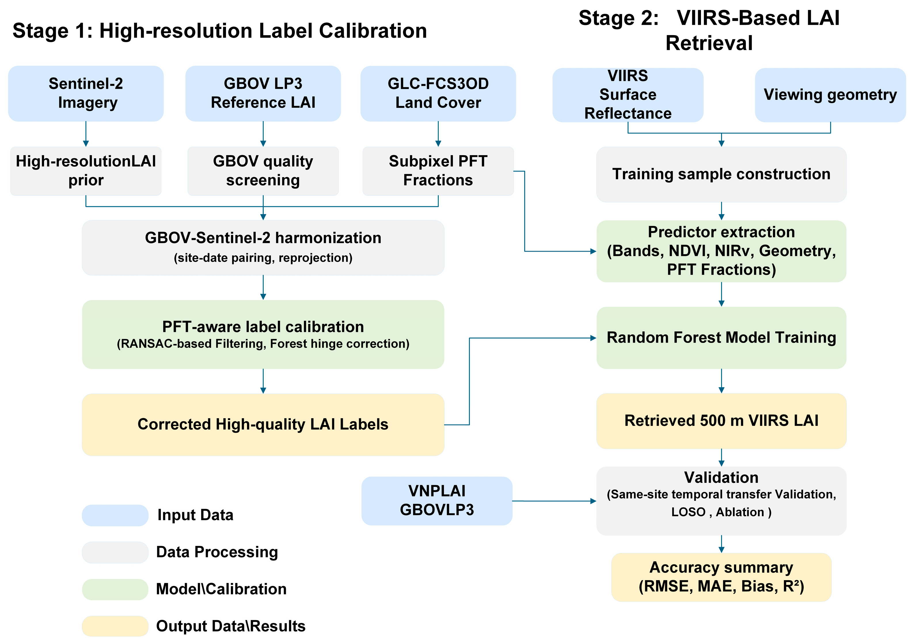
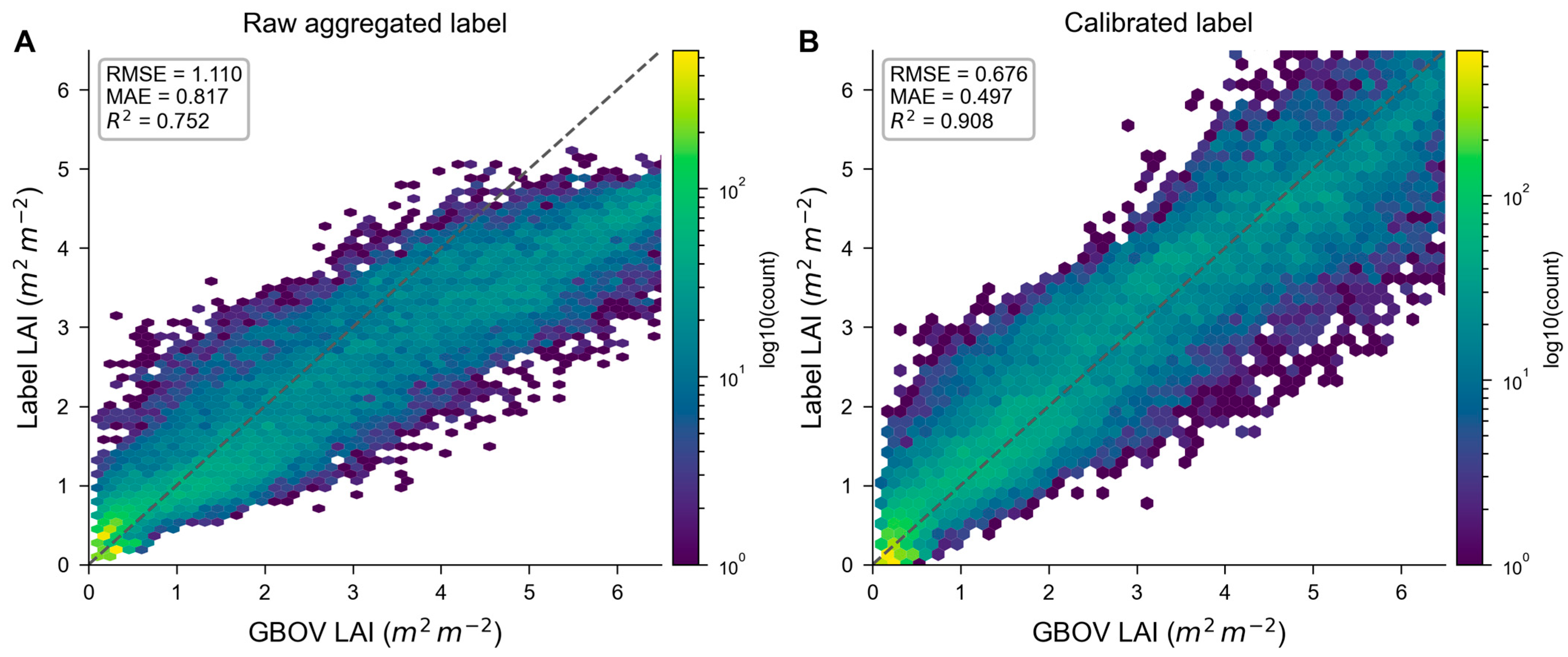
- A GBOV-anchored two-stage workflow substantially improved 500 m VIIRS LAI retrieval over mixed pixels by correcting supervisory labels before final inversion.
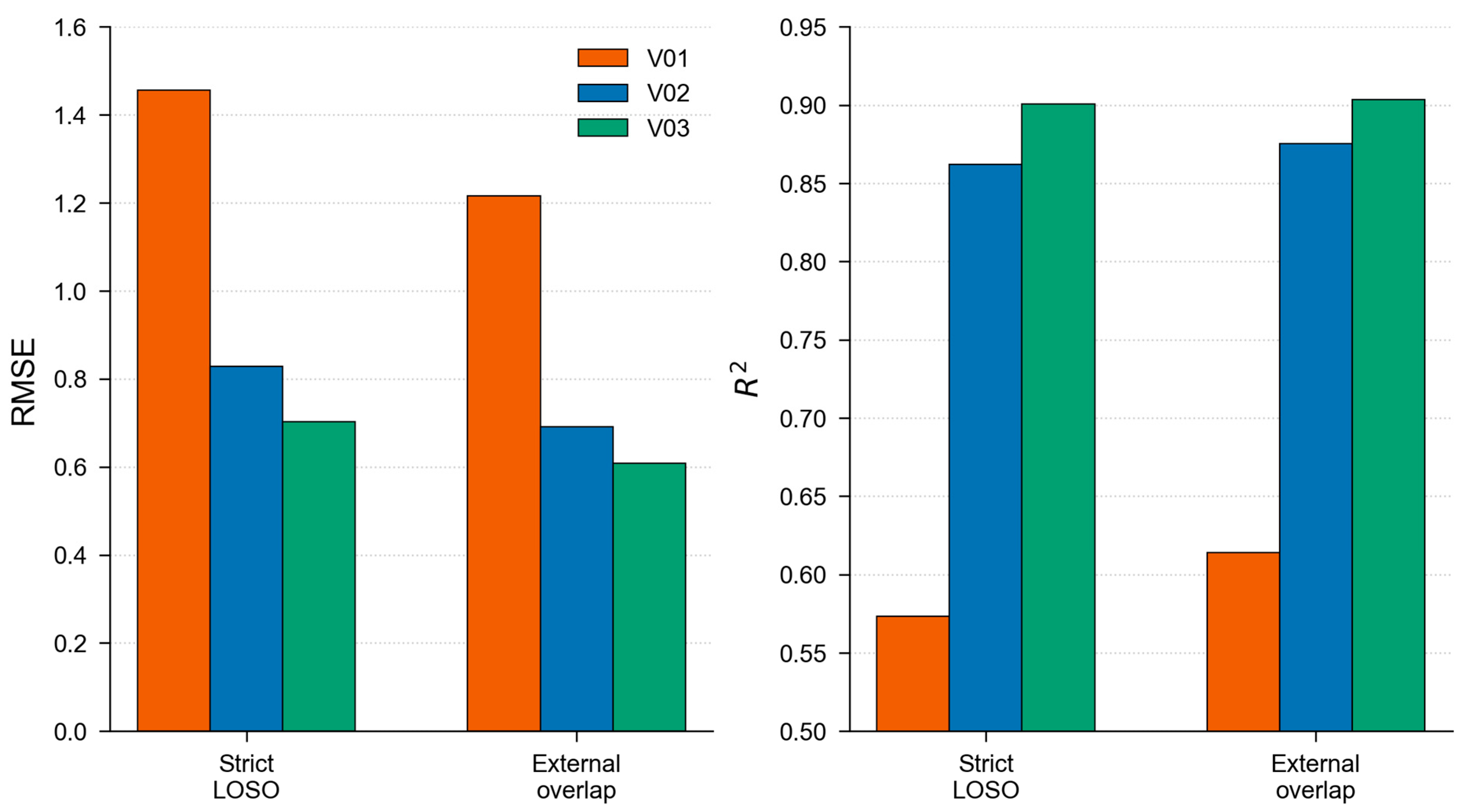
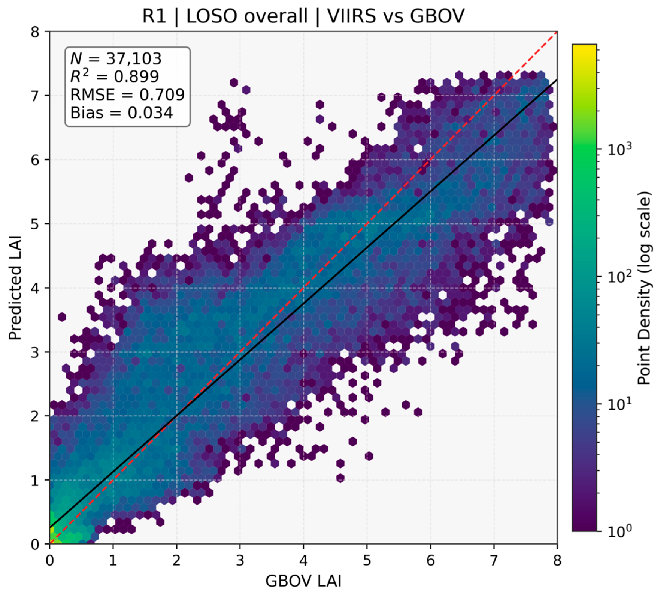
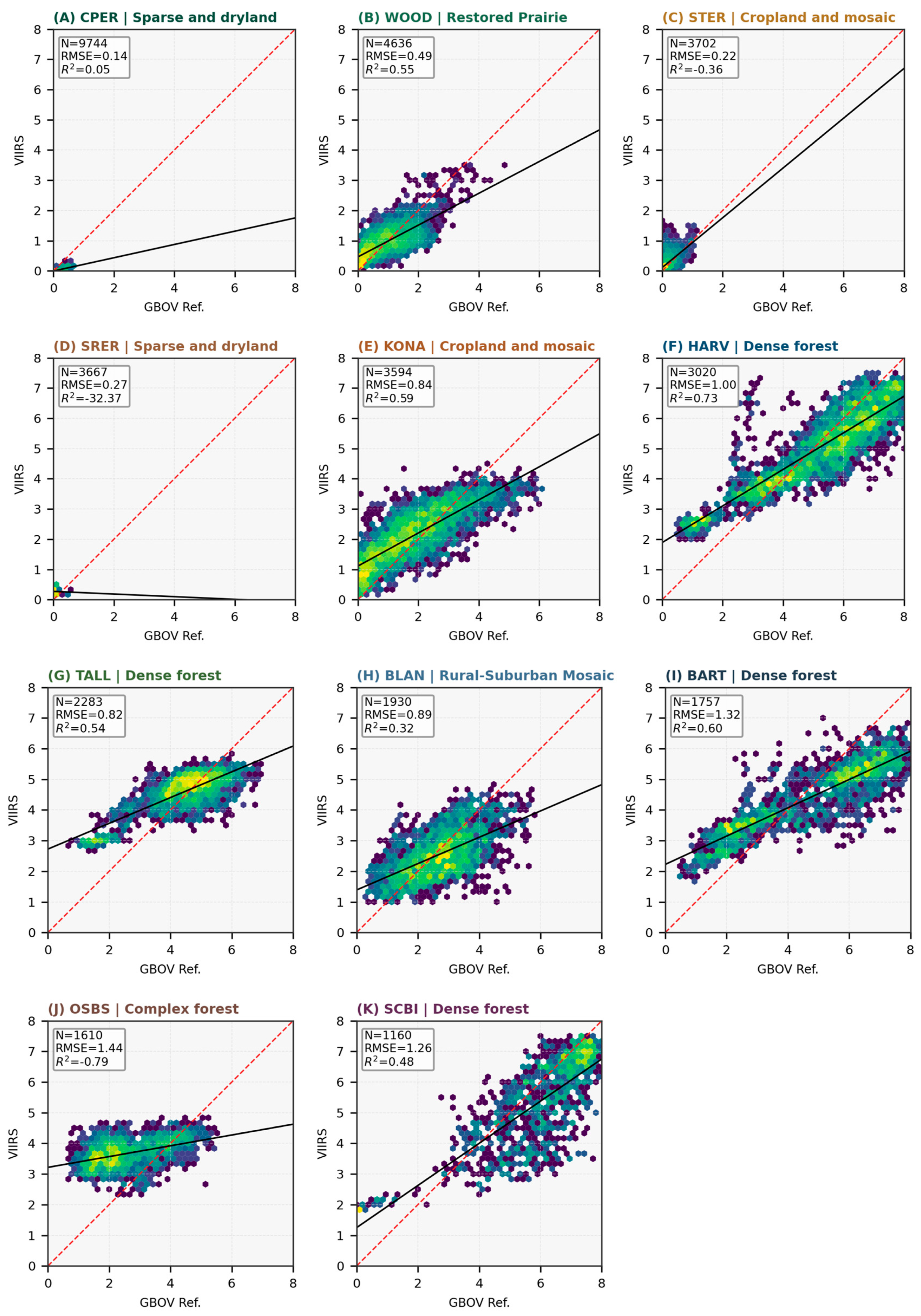
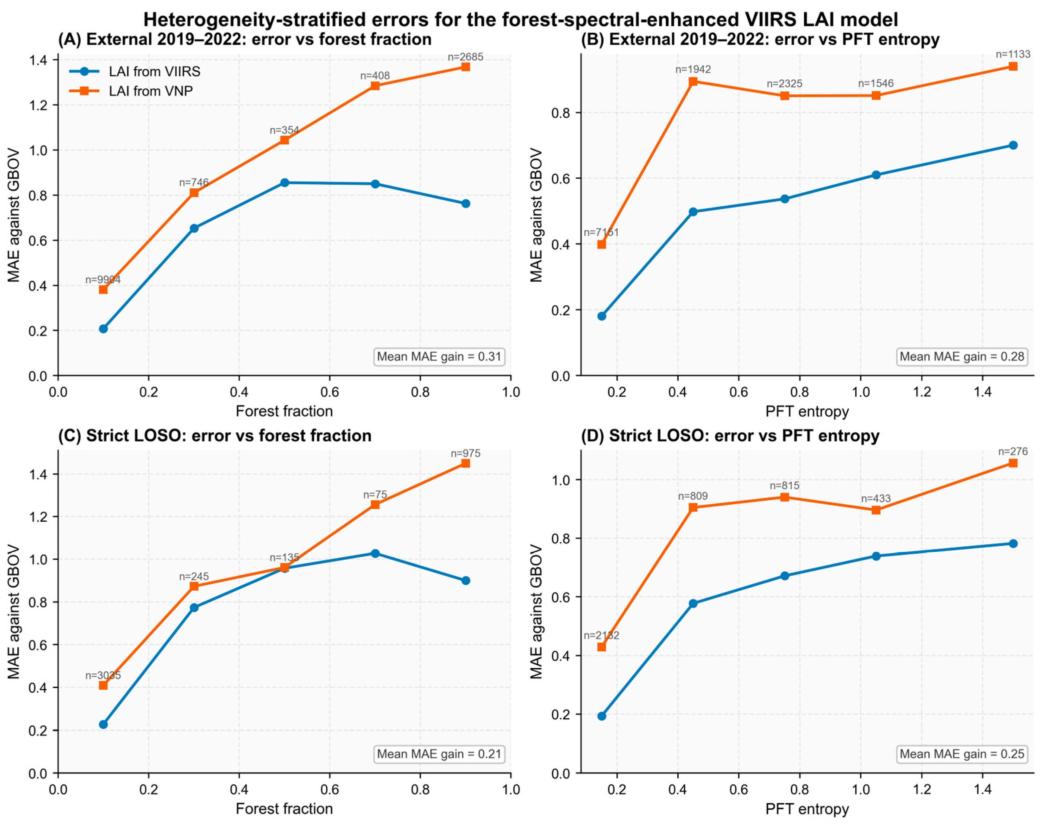
- The largest performance gain came from label correction, while subpixel PFT information provided an additional and consistent improvement over both LOSO validation and same-site temporal-transfer evaluation.
- Mixed-pixel LAI retrieval should be treated not only as a predictor-side problem, but also as a supervisory-label quality problem when high-resolution products are aggregated to moderate resolution.
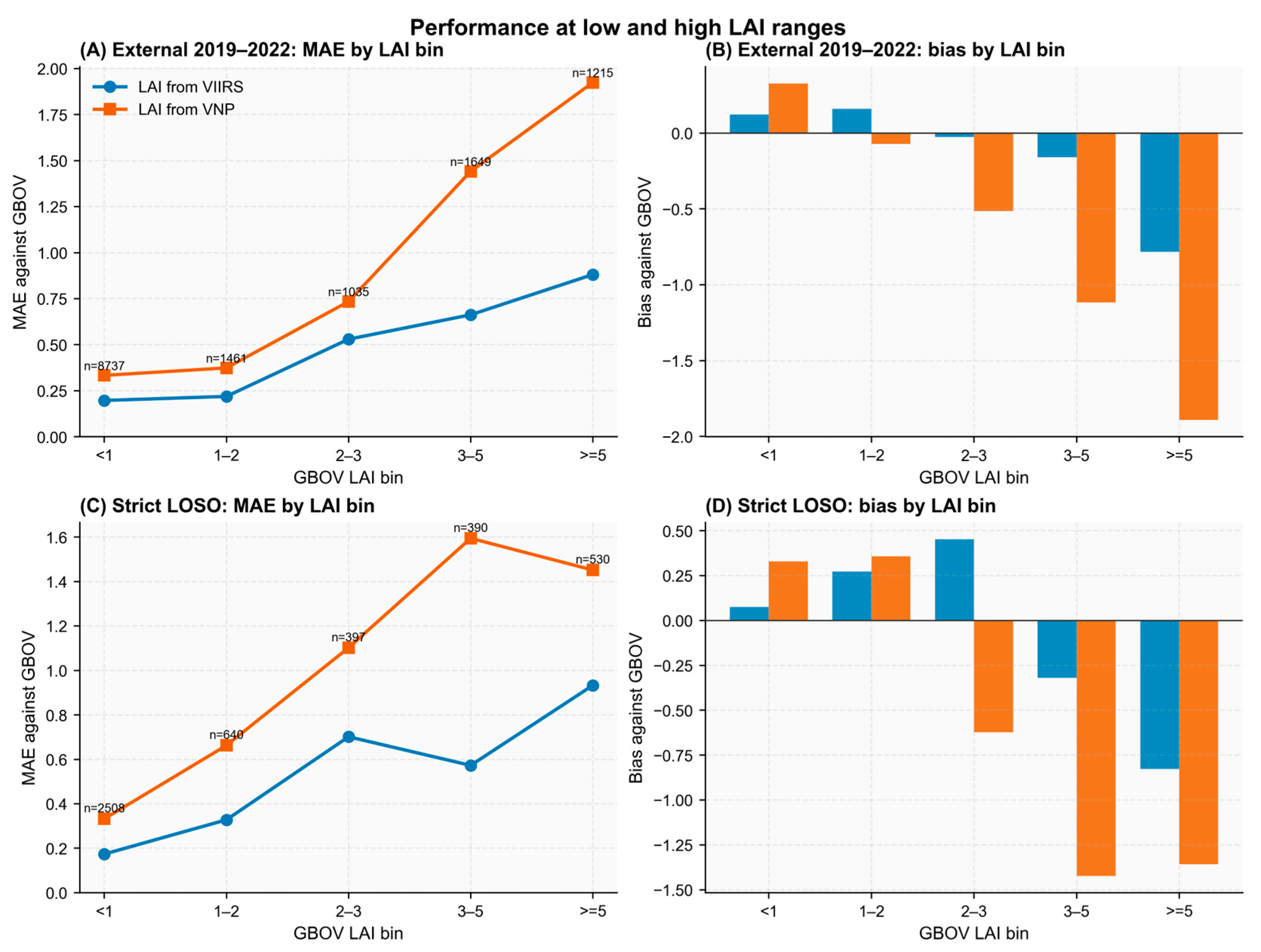
- Reference-guided label correction provides a practical way to improve operational VIIRS LAI retrieval in heterogeneous landscapes, especially where dense canopies and canopy-background mixing remain challenging.
Abstract
1. Introduction
2. Materials and Methods
2.1. Study Area and Dataset
2.1.1. VIIRS Surface Reflectance
2.1.2. Sentinel-2 High-Resolution LAI and Subpixel PFT Composition
2.1.3. GBOV LP3 Reference LAI Data
2.2. Method
2.2.1. Overall Framework
2.2.2. Spatiotemporal Harmonization
2.2.3. GBOV-Anchored PFT-Aware Label Calibration
2.2.4. VIIRS LAI Retrieval with Subpixel Heterogeneity
2.2.5. Evaluation Design
3. Results
3.1. Ablation of Label Correction and PFT Information
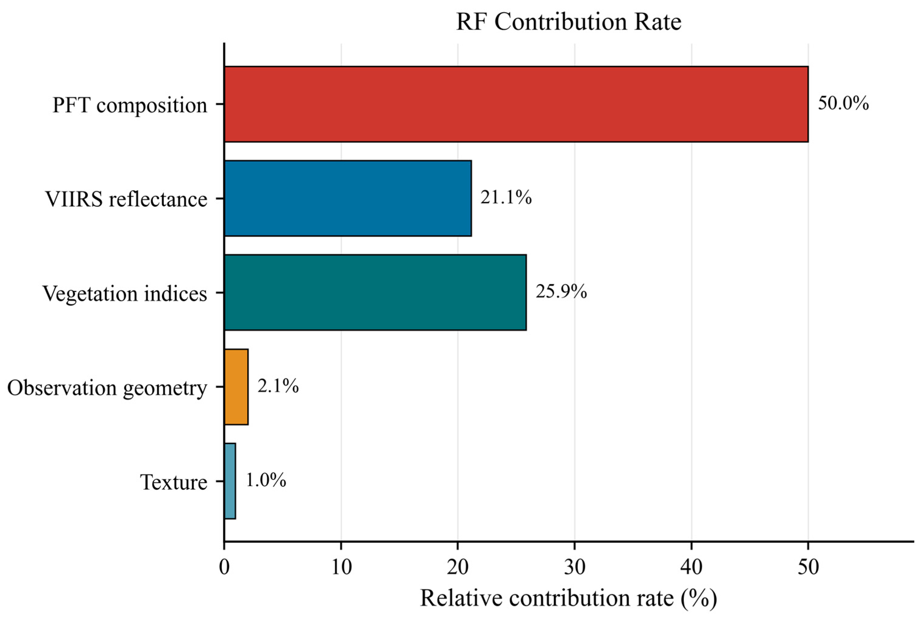
3.2. Feature Importance of the Final Retrieval Model
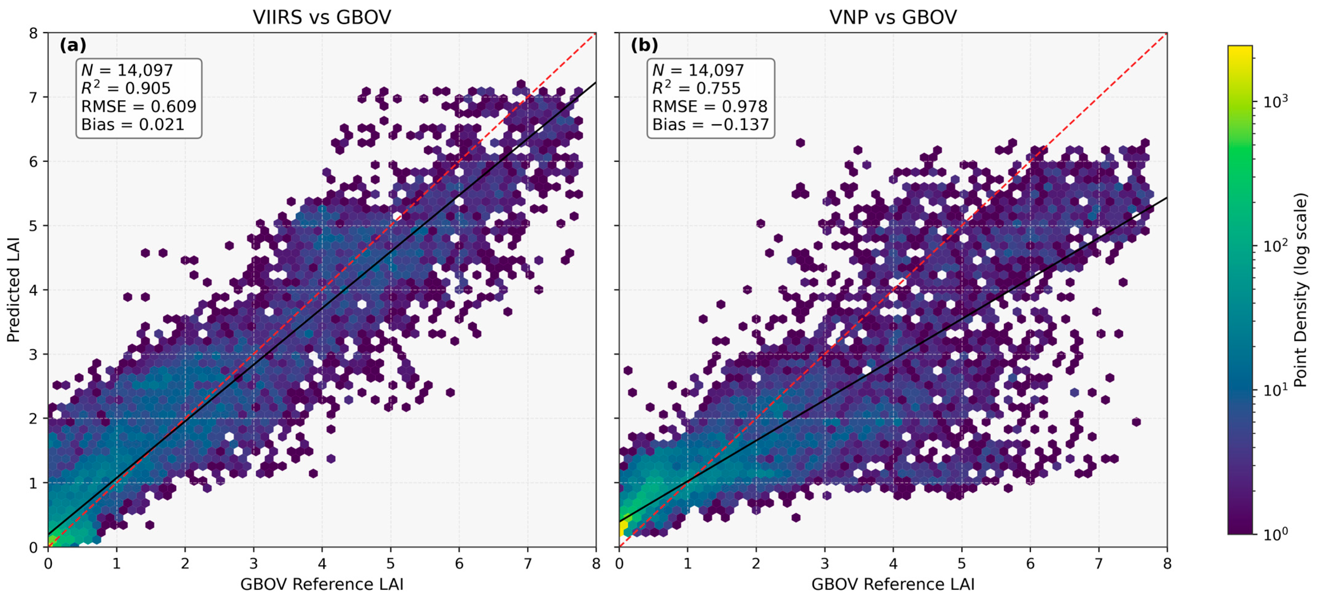
3.3. Comparison with the Official VNP Product
3.4. LOSO Validation
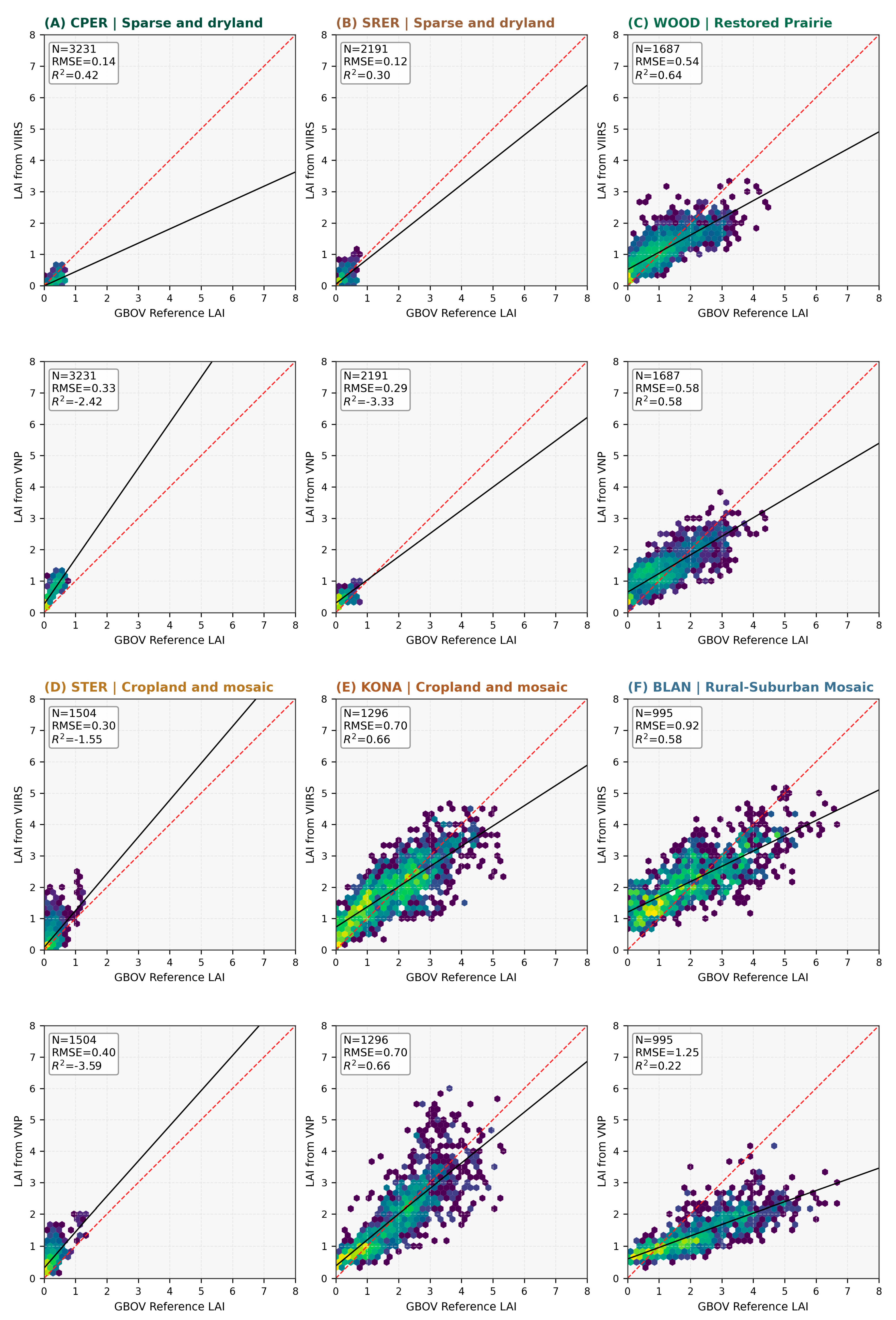
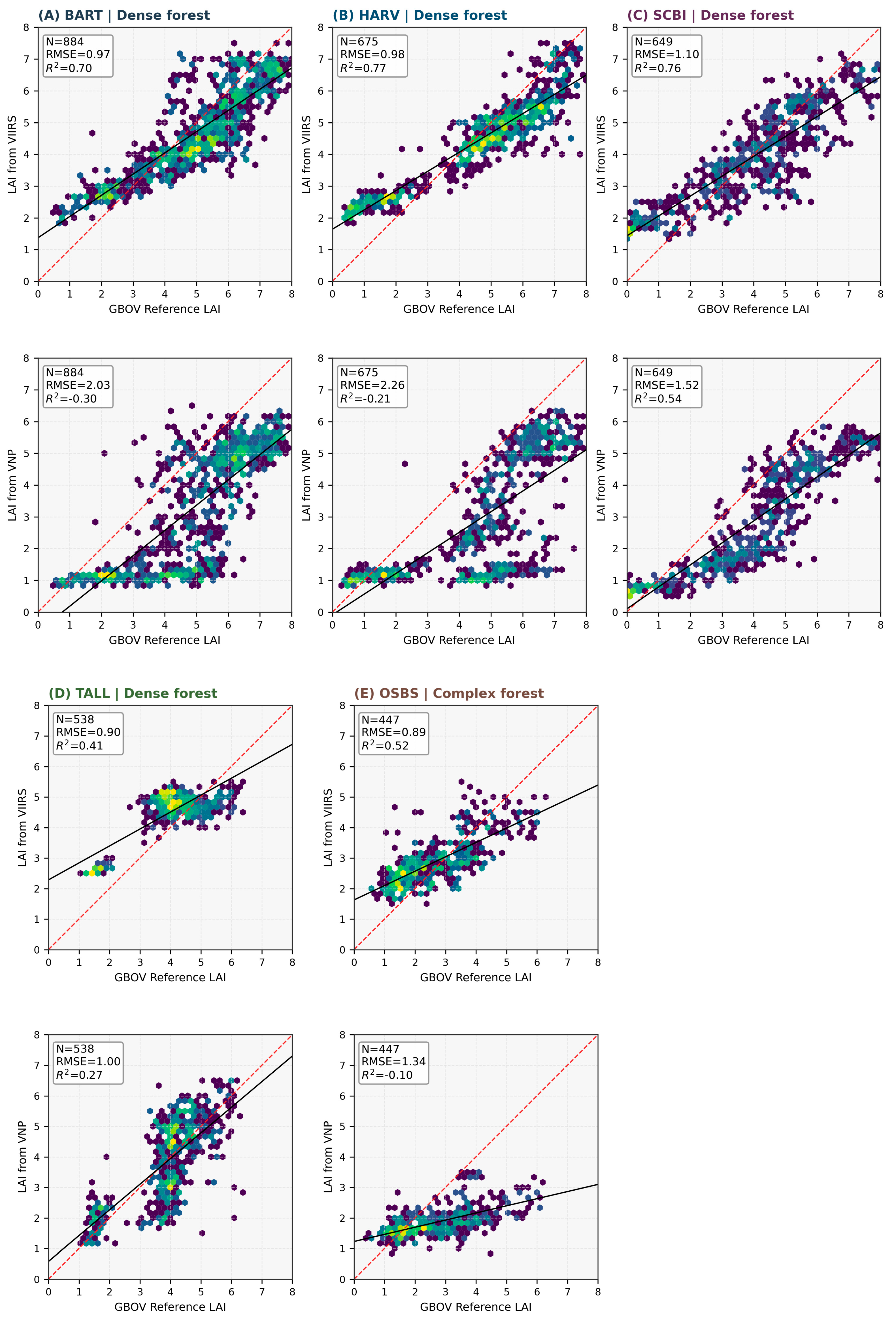
3.5. Heterogeneity-Stratified Error Analysis
4. Discussion
4.1. Interpretation of the Two-Stage Improvement
4.2. Relationship to Existing Mixed-Pixel and VIIRS LAI Studies
4.3. Performance Across Heterogeneity and LAI Gradients
4.4. Limitations and Domain of Applicability
4.5. Implications and Future Work
5. Conclusions
Author Contributions
Funding
Data Availability Statement
Acknowledgments
Conflicts of Interest
References
- World Meteorological Organization. Leaf Area Index. Available online: https://space.oscar.wmo.int/variables/view/leaf_area_index_lai (accessed on 24 April 2026).
- Zheng, G.; Moskal, L.M. Retrieving leaf area index (LAI) using remote sensing: Theories, methods and sensors. Sensors 2009, 9, 2719–2745. [Google Scholar] [CrossRef] [PubMed]
- Myneni, R.B.; Hoffman, S.; Knyazikhin, Y.; Privette, J.L.; Glassy, J.; Tian, Y.; Wang, Y.; Song, X.; Zhang, Y.; Smith, G.R.; et al. Global products of vegetation leaf area and fraction absorbed PAR from year one of MODIS data. Remote Sens. Environ. 2002, 83, 214–231. [Google Scholar] [CrossRef]
- Mthembu, N.; Lottering, R.; Kotze, H. Forest, crop and grassland leaf area index estimation using remote sensing: A review of current research methods, sensors, estimation models and accomplishments. Appl. Sci. 2023, 13, 4005. [Google Scholar] [CrossRef]
- Tian, Y.; Woodcock, C.E.; Wang, Y.; Privette, J.L.; Shabanov, N.V.; Zhou, L.; Zhang, Y.; Buermann, W.; Dong, J.; Veikkanen, B.; et al. Multiscale analysis and validation of the MODIS LAI product: I. Uncertainty assessment. Remote Sens. Environ. 2002, 83, 414–430. [Google Scholar] [CrossRef]
- Tian, Y.; Wang, Y.; Zhang, Y.; Knyazikhin, Y.; Bogaert, J.; Myneni, R.B. Multiscale analysis and validation of the MODIS LAI product: II. Sampling strategy. Remote Sens. Environ. 2002, 83, 431–441. [Google Scholar] [CrossRef]
- Garrigues, S.; Allard, D.; Baret, F.; Weiss, M. Influence of landscape spatial heterogeneity on the non-linear estimation of leaf area index from moderate spatial resolution remote sensing data. Remote Sens. Environ. 2006, 105, 286–298. [Google Scholar] [CrossRef]
- Fang, H.; Wei, S.; Liang, S. Theoretical uncertainty analysis of global MODIS, CYCLOPES, and GLOBCARBON LAI products using a triple collocation method. Remote Sens. Environ. 2012, 124, 610–621. [Google Scholar] [CrossRef]
- Brown, L.A.; Meier, C.; Morris, H.; Pastor-Guzman, J.; Bai, G.; Lerebourg, C.; Gobron, N.; Lanconelli, C.; Clerici, M.; Dash, J. Evaluation of global leaf area index and fraction of absorbed photosynthetically active radiation products over North America using Copernicus Ground Based Observations for Validation data. Remote Sens. Environ. 2020, 247, 111935. [Google Scholar] [CrossRef]
- Yan, K.; Park, T.; Yan, G.; Chen, C.; Yang, B.; Liu, Z.; Nemani, R.R.; Knyazikhin, Y.; Myneni, R.B. Performance stability of the MODIS and VIIRS LAI algorithms inferred from analysis of long time series of products. Remote Sens. Environ. 2021, 260, 112438. [Google Scholar] [CrossRef]
- Xu, B.; Li, J.; Park, T.; Liu, H.; Xiao, Z.; Knyazikhin, Y. Improving leaf area index retrieval over heterogeneous surface mixed with water. Remote Sens. Environ. 2020, 240, 111700. [Google Scholar] [CrossRef]
- Dong, Y.; Li, J.; Jiao, Z.; Liu, Q.; Zhao, J.; Xu, B.; Zhang, H.; Zhang, Z.; Liu, C.; Knyazikhin, Y.; et al. A method for retrieving coarse-resolution leaf area index for mixed biomes using a mixed-pixel correction factor. IEEE Trans. Geosci. Remote Sens. 2023, 61, 4400317. [Google Scholar] [CrossRef]
- Wan, L.; Ryu, Y.; Dechant, B.; Hwang, Y.; Feng, H.; Kang, Y.; Jeong, S.; Lee, J.; Choi, C.; Bae, J. Correcting confounding canopy structure, biochemistry and soil background effects improves leaf area index estimates across diverse ecosystems from Sentinel-2 imagery. Remote Sens. Environ. 2024, 309, 114224. [Google Scholar] [CrossRef]
- Jin, W.; Zhang, Z.; Wu, T.; Meng, K.; Wang, Q.; Tong, W.; Wang, C.; Yin, G.; Xu, B. Retrieval of leaf area index from MODIS surface reflectance by incorporating the subpixel information from decametric-resolution data. IEEE Trans. Geosci. Remote Sens. 2024, 62, 1–17. [Google Scholar] [CrossRef]
- Zou, D.; Yan, K.; Pu, J.; Gao, S.; Li, W.; Mu, X.; Knyazikhin, Y.; Myneni, R.B. Revisit the performance of MODIS and VIIRS leaf area index products from the perspective of time-series stability. IEEE J. Sel. Top. Appl. Earth Obs. Remote Sens. 2022, 15, 8958–8973. [Google Scholar] [CrossRef]
- Li, J.; Xiao, Z.; Sun, R.; Song, J. Retrieval of the leaf area index from Visible Infrared Imaging Radiometer Suite (VIIRS) surface reflectance based on unsupervised domain adaptation. Remote Sens. 2022, 14, 1826. [Google Scholar] [CrossRef]
- Li, J.; Xiao, Z.; Sun, R.; Song, J. A method to estimate leaf area index from VIIRS surface reflectance using deep transfer learning. ISPRS J. Photogramm. Remote Sens. 2023, 202, 512–527. [Google Scholar] [CrossRef]
- Peng, R.; Yan, K.; Liu, J.; Gao, S.; Pu, J.; Maeda, E.E.; Zhu, P.; Knyazikhin, Y.; Myneni, R.B. Revisiting the consistency of MODIS LAI products from a new perspective of spatiotemporal variability. Int. J. Digit. Earth 2024, 17, 2407045. [Google Scholar] [CrossRef]
- Zhang, X.; Liu, J.; Yang, K.; Pu, J.; Yan, G.; Heiskanen, J.; Zhu, P.; Knyazikhin, Y.; Myneni, R.B. An insight into the internal consistency of MODIS global leaf area index products. IEEE Trans. Geosci. Remote Sens. 2024, 62, 4411716. [Google Scholar] [CrossRef]
- Pu, J.; Yan, K.; Roy, S.; Zhu, Z.; Rautiainen, M.; Knyazikhin, Y.; Myneni, R.B. Sensor-independent LAI/FPAR CDR: Reconstructing a global sensor-independent climate data record of MODIS and VIIRS LAI/FPAR from 2000 to 2022. Earth Syst. Sci. Data 2024, 16, 15–34. [Google Scholar] [CrossRef]
- Pu, J.; Yan, K.; Gao, S.; Zhang, Y.; Park, T.; Sun, X.; Weiss, M.; Knyazikhin, Y.; Myneni, R.B. Improving the MODIS LAI compositing using prior time-series information. Remote Sens. Environ. 2023, 287, 113493. [Google Scholar] [CrossRef]
- Wang, J.; Yan, K.; Gao, S.; Pu, J.; Liu, J.; Park, T.; Bi, J.; Maeda, E.E.; Heiskanen, J.; Knyazikhin, Y.; et al. Improving the quality of MODIS LAI products by exploiting spatiotemporal correlation information. IEEE Trans. Geosci. Remote Sens. 2023, 61, 4402319. [Google Scholar] [CrossRef]
- Yan, K.; Wang, J.; Peng, R.; Yang, K.; Chen, X.; Yin, G.; Dong, J.; Weiss, M.; Pu, J.; Myneni, R.B. HiQ-LAI: A high-quality reprocessed MODIS leaf area index dataset with better spatiotemporal consistency from 2000 to 2022. Earth Syst. Sci. Data 2024, 16, 1601–1622. [Google Scholar] [CrossRef]
- National Ecological Observatory Network. Explore Field Sites. Available online: https://www.neonscience.org/field-sites/explore-field-sites (accessed on 24 April 2026).
- Copernicus Land Monitoring Service. Ground-Based Observations for Validation (GBOV). Available online: https://land.copernicus.eu/en/products/GBOV (accessed on 24 April 2026).
- Vermote, E.; Franch, B.; Claverie, M. VIIRS/NPP Surface Reflectance Daily L2G Global 1 Km and 500 M SIN Grid V002; NASA EOSDIS Land Processes Distributed Active Archive Center: Sioux Falls, SD, USA, 2023. [CrossRef]
- NASA Land Processes Distributed Active Archive Center. Suomi-NPP VIIRS Surface Reflectance User’s Guide: V2 Reprocessing, Version 2.0. Available online: https://lpdaac.usgs.gov/documents/1657/VNP09_User_Guide_V2.pdf (accessed on 24 April 2026).
- Zhang, X.; Liu, L.; Chen, X.; Gao, Y.; Xie, S.; Mi, J. GLC_FCS30: Global land-cover product with fine classification system at 30 m using time-series Landsat imagery. Earth Syst. Sci. Data 2021, 13, 2753–2776. [Google Scholar] [CrossRef]
- Copernicus Land Monitoring Service. Algorithm Theoretical Basis Document for Vegetation Products: LP3 LAI, LP4 FAPAR and LP5 FCOVER, Version 3.2. Available online: https://land.copernicus.eu/en/technical-library/algorithm-theoretical-basis-document-for-vegetation-products-lp-3-lai-lp-4-fapar-and-lp-5-fcover/%40%40download/file (accessed on 24 April 2026).
- Fischler, M.A.; Bolles, R.C. Random sample consensus: A paradigm for model fitting with applications to image analysis and automated cartography. Commun. ACM 1981, 24, 381–395. [Google Scholar] [CrossRef]
- Zhao, J.; Li, J.; Liu, Q.; Yang, L. A preliminary study on mechanism of LAI inversion saturation. Int. Arch. Photogramm. Remote Sens. Spat. Inf. Sci. 2012, XXXIX-B1, 77–81. [Google Scholar] [CrossRef]
- Baret, F.; Hagolle, O.; Geiger, B.; Bicheron, P.; Miras, B.; Huc, M.; Berthelot, B.; Niño, F.; Weiss, M.; Samain, O.; et al. LAI, fAPAR and fCover CYCLOPES global products derived from VEGETATION: Part 1: Principles of the algorithm. Remote Sens. Environ. 2007, 110, 275–286. [Google Scholar] [CrossRef]
- Breiman, L. Random forests. Mach. Learn. 2001, 45, 5–32. [Google Scholar] [CrossRef]
- Belgiu, M.; Drăguţ, L. Random forest in remote sensing: A review of applications and future directions. ISPRS J. Photogramm. Remote Sens. 2016, 114, 24–31. [Google Scholar] [CrossRef]
- Meyer, H.; Pebesma, E. Predicting into unknown space? Estimating the area of applicability of spatial prediction models. Methods Ecol. Evol. 2021, 12, 1620–1633. [Google Scholar] [CrossRef]
- Roberts, D.R.; Bahn, V.; Ciuti, S.; Boyce, M.S.; Elith, J.; Guillera-Arroita, G.; Hauenstein, S.; Lahoz-Monfort, J.J.; Schröder, B.; Thuiller, W.; et al. Cross-validation strategies for data with temporal, spatial, hierarchical, or phylogenetic structure. Ecography 2017, 40, 913–929. [Google Scholar] [CrossRef]



| GBOV LAI Interval | RMSE | MAE | Bias |
|---|---|---|---|
| 0–1 | 0.395 | 0.270 | 0.193 |
| 1–2 | 0.559 | 0.443 | −0.024 |
| 2–3 | 0.688 | 0.576 | −0.335 |
| 3–4 | 0.839 | 0.682 | −0.562 |
| 4–5 | 1.181 | 1.048 | −1.033 |
| 5–6 | 1.626 | 1.557 | −1.557 |
| 6–8 | 2.259 | 2.216 | −2.216 |
| Group | Variables |
|---|---|
| VIIRS reflectance | I1_RED, I2_NIR, I3_SWIR, M3_BLUE, M4_GREEN, M11_SWIR2 |
| Vegetation indices | NDVI, NIRv |
| Observation geometry | SZA, VZA, RAA, cos(SZA), cos(VZA), cos(RAA) |
| Texture | 3 × 3 NDVI standard deviation |
| PFT composition | Frac_CRO, Frac_SHR, Frac_GRA, Frac_WSA, Frac_WET, Frac_ENF, Frac_EBF, Frac_DBF, Frac_MF, Dominant-component fraction |
| Model | LOSO | Same-Site Temporal Transfer | ||||
|---|---|---|---|---|---|---|
| RMSE | MAE | R2 | RMSE | MAE | R2 | |
| v01 | 1.457 | 0.932 | 0.573 | 1.216 | 0.743 | 0.614 |
| v02 | 0.828 | 0.518 | 0.862 | 0.710 | 0.452 | 0.878 |
| v03 | 0.703 | 0.452 | 0.901 | 0.608 | 0.379 | 0.900 |
Disclaimer/Publisher’s Note: The statements, opinions and data contained in all publications are solely those of the individual author(s) and contributor(s) and not of MDPI and/or the editor(s). MDPI and/or the editor(s) disclaim responsibility for any injury to people or property resulting from any ideas, methods, instructions or products referred to in the content. |
© 2026 by the authors. Licensee MDPI, Basel, Switzerland. This article is an open access article distributed under the terms and conditions of the Creative Commons Attribution (CC BY) license.
Share and Cite
Yue, T.; Ding, H.; Zhang, Y. A Two-Stage Reference-Guided Workflow for Improving VIIRS Leaf Area Index Retrieval over Mixed Pixels. Remote Sens. 2026, 18, 2214. https://doi.org/10.3390/rs18132214
Yue T, Ding H, Zhang Y. A Two-Stage Reference-Guided Workflow for Improving VIIRS Leaf Area Index Retrieval over Mixed Pixels. Remote Sensing. 2026; 18(13):2214. https://doi.org/10.3390/rs18132214
Chicago/Turabian StyleYue, Tengqi, Haiyong Ding, and Yuanfei Zhang. 2026. "A Two-Stage Reference-Guided Workflow for Improving VIIRS Leaf Area Index Retrieval over Mixed Pixels" Remote Sensing 18, no. 13: 2214. https://doi.org/10.3390/rs18132214
APA StyleYue, T., Ding, H., & Zhang, Y. (2026). A Two-Stage Reference-Guided Workflow for Improving VIIRS Leaf Area Index Retrieval over Mixed Pixels. Remote Sensing, 18(13), 2214. https://doi.org/10.3390/rs18132214