Technical Note

Comprehensive Validation of ICESat-2 ATL08 Terrain Height Product Using High-Resolution DSM: A Multi-Site Study in Central-South China

1
School of Civil Architectural Engineering, Shaoyang University, Shaoyang 422000, China
2
School of Automation and Electronic Information, Xiangtan University, Xiangtan 411105, China
3
China Construction Huxiang Design Co., Ltd., Changsha 410000, China
4
Shaoyang City Planning and Design Institute, Shaoyang 422000, China
*
Author to whom correspondence should be addressed.
Remote Sens. 2026, 18(13), 2160; https://doi.org/10.3390/rs18132160
Submission received: 7 May 2026 / Revised: 16 June 2026 / Accepted: 30 June 2026 / Published: 3 July 2026
(This article belongs to the Section Satellite Missions for Earth and Planetary Exploration)

Highlights

What are the main findings?
  • Validation across 18 sites reveals a mean RMSE of 3.318 m for ATL08 terrain height in central-south China, with accuracy exhibiting a clear terrain-dependent gradient from plains (RMSE ≈ 1.044 m) to alpine canyons (RMSE ≈ 4.280 m).
What are the implications of the main findings?
  • The terrain-dependent accuracy gradient provides a quantitative benchmark for users to anticipate ATL08 performance based on local topographic complexity.

Abstract

ICESat-2 ATL08 is an important data source for global land surface elevation monitoring, while its accuracy has not been systematically evaluated in the complex terrain areas of central and southern China. Taking high-resolution digital surface models as reference data, this study carries out systematic verification with a total of 949 valid verification points covering 18 typical geomorphological areas in central and southern China. The verification sites cover various terrain types including plains, hills, mountains and alpine canyons. The results show that the average root mean square error of all sites is 3.318 m, ranging from 1.044 m to 5.120 m. Among them, plain areas have the highest accuracy (HS, RMSE = 1.044 m), followed by hilly areas with RMSE of approximately 1.610–3.871 m, and mountainous and alpine canyon areas show relatively poorer accuracy with RMSE of approximately 2.374–5.120 m. The overall mean error (ME) is −1.032 m, with ME values ranging from −4.575 m to +2.548 m across sites. The accuracy of ICESat-2 ATL08 in central-southern China is highly terrain-dependent: RMSE is 1.044 m in the plain site and ranges from 1.610 to 3.871 m in hilly areas and from 2.374 to 5.120 m in mountainous and alpine canyon areas. Therefore, users should consider terrain complexity when applying this product, and post-processing correction incorporating topographic information is recommended for alpine canyon areas where RMSE exceeds 5 m.

1. Introduction

ICESat-2 (Ice, Cloud, and Land Elevation Satellite-2) has become an important data source for global land surface elevation monitoring since its launch in 2018, benefiting from the onboard ATLAS (Advanced Topographic Laser Altimeter System) sensor [1,2]. Its ATL08 land and vegetation elevation product is specially designed to retrieve terrain elevation and canopy height in vegetation-covered areas. Traditional optical remote sensing is vulnerable to cloud and fog interference, and radar interferometry tends to lose coherence in steep terrain. In contrast, photon-counting LiDAR can penetrate vegetation canopies and obtain elevation information closer to the real ground surface. Accordingly, ATL08 data have been widely used in global forest carbon sink estimation, land planning and design, and the calibration and validation of digital elevation models [3,4,5].
In terms of terrain height verification, existing studies generally agree that ATL08 exhibits excellent vertical accuracy in flat areas or regions covered by low vegetation [6]. The validation conducted by Neuenschwander et al. using airborne LiDAR (ALS) in boreal forests shows that the root mean square error (RMSE) of its terrain elevation can reach 0.73 m [7,8]. Subsequent global-scale verification by Wang et al. further confirmed that ATL08 can achieve sub-meter terrain retrieval in non-forest areas, while its accuracy is highly dependent on surface slope [9,10,11]. In regions with complex terrain, the geometric stretching of footprints on slopes causes ranging deviation from the true ground surface. Dandabathula et al. pointed out that terrain undulation remains the main cause of vertical bias even under strong beam observations [12].
To explore the potential of ICESat-2 data, academic investigations have been conducted from multiple perspectives. At the data filtering level, Shang D et al. developed an extraction method integrating the accuracy and positional requirements of control points based on ATL08 data. After eliminating elevation abnormal points caused by surface changes and misclassification, the control points extracted by this method can achieve an elevation accuracy of 0.3 m [13]. Yang J et al. constructed an ICESat-2 data processing framework ranging from underlying physical modeling to high-level parameter inversion [14,15,16]. Zhang X L et al. screened ATL03 and ATL according to evaluation labels, and the accuracy of the screened control points was improved by 54.46% [17]. Wang M et al. established a global laser point control database containing 560 million points using ICESat-2 ATL08 data, among which 90% of control points possess elevation accuracy better than 0.7 m [18]. Collectively, these studies reveal that ATL08 data exhibit great inherent potential in raw measurement accuracy, yet their practical performance hinges largely on appropriate post-processing and quality control.
However, obvious deficiencies still exist in current studies. First, most validation efforts focus on flat areas in North America, Europe and northern China, while large-scale validation for complex terrain in central and southern China, such as the hills of western Hunan and alpine canyon areas of western Sichuan, is seriously insufficient. Second, many studies adopt SRTM (30 m resolution) or ASTER GDEM as the true reference values. In regions with dramatic elevation variations, these global DEM products themselves contain errors of several meters or even tens of meters, resulting in evaluation bias equivalent to using an inaccurate ruler to measure another one. For example, a recent comprehensive evaluation by Liu et al. [19] using high-precision GPS control points (vertical accuracy < 0.1 m) across 16 regions in China—including Hunan, Sichuan, and Henan, which overlap with our study areas—reported that SRTM (30 m) exhibits RMSE values ranging from 1.059 m to 4.894 m, with errors typically between 3 and 5 m in hilly and mountainous terrains. ASTER GDEM (30 m) shows significantly lower accuracy, with RMSE ranging from 2.710 m to 19.367 m and values exceeding 6–10 m in most areas of central-south China. Such error magnitudes are comparable to or even larger than the ATL08 terrain height errors we aim to evaluate. Therefore, using SRTM or ASTER GDEM as reference would inevitably introduce substantial bias, especially in complex terrain regions.
To fill the above research gaps, this study adopts high-resolution digital surface models as reference data to conduct a systematic validation of ICESat-2 ATL08 data across 18 typical geomorphological regions in central and southern China. Compared with previous studies, this work has the following advantages: (1) a large sample size, with a total of 949 valid verification points covering multiple terrain types including plains, hills, mountains and alpine canyons; (2) high-quality reference data. The adopted high-resolution DSM possesses fine spatial resolution and high vertical accuracy, which can more reliably represent the real surface elevation and provide a more accurate reference benchmark for the accuracy evaluation of ATL08 than those in previous studies.
This study aims to address the following two key scientific questions: (1) What is the quantitative range of the vertical accuracy of the ATL08 product, measured by RMSE and MAE, across different geomorphological zones in central and southern China? Does the vertical accuracy exhibit geomorphology-dependent variability? (2) What spatial distribution characteristics do the elevation errors of ATL08 present under varied terrain conditions?
The remainder of this paper is organized as follows. Section 2 introduces the overview of the study area and data sources. Section 3 elaborates the data matching method, accuracy evaluation metrics and the screening procedure for valid points. Section 4 presents the validation results. Section 5 discusses the error causes. Section 6 summarizes the main conclusions.

2. Study Area and Data

2.1. Study Area

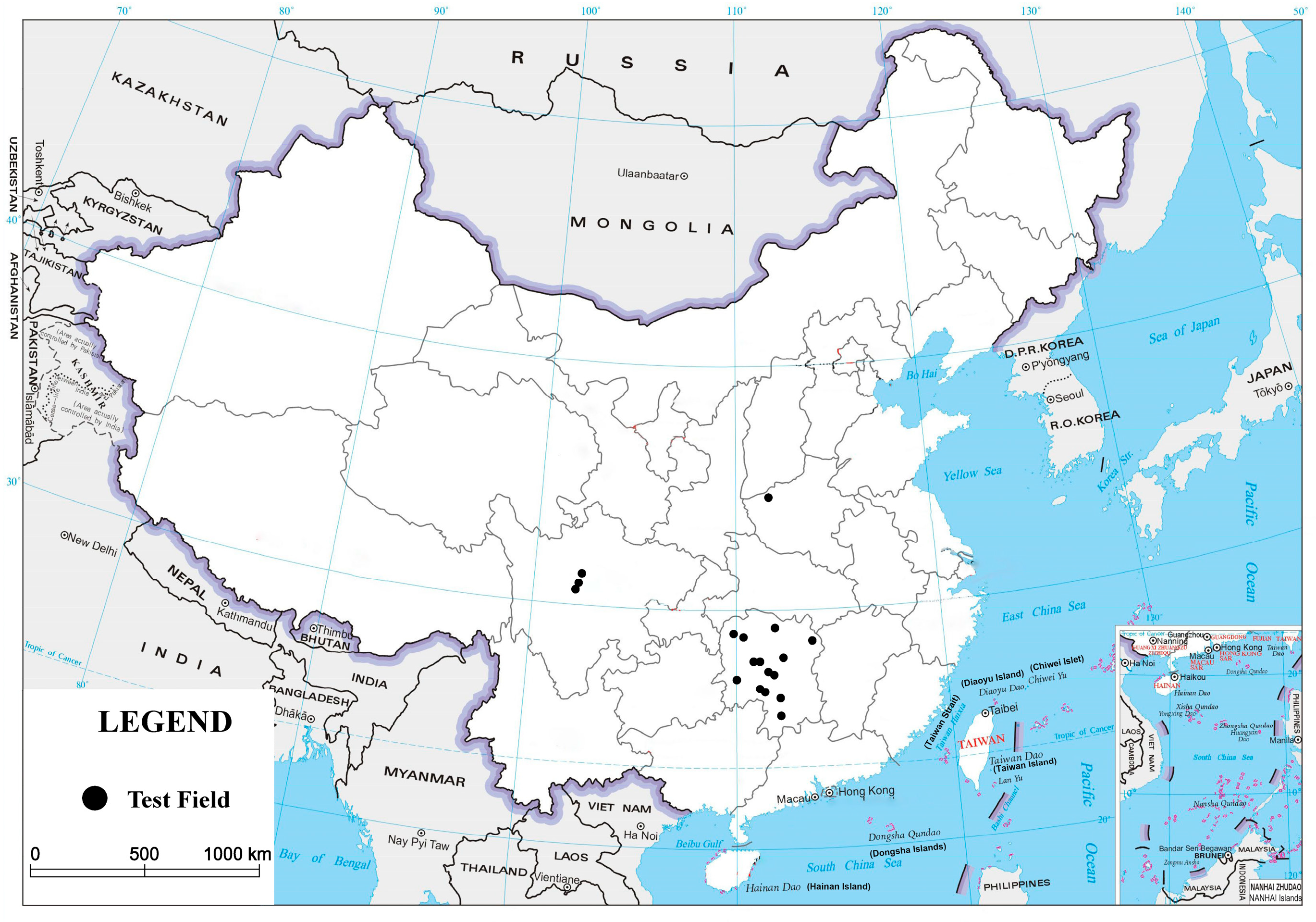
This study selects 18 typical geomorphological regions in central and southern China as validation sites, which are geographically distributed across Hunan, Sichuan, Henan and other provinces, with their spatial distribution shown in Figure 1. According to topographic characteristics, these sites are classified into four categories: plain area (one site), hilly area (five sites), mountainous area (nine sites), and alpine canyon area (three sites). The basic information of each site is listed in Table 1.
Among them, Hanshou is located in the Dongting Lake Plain with an elevation of approximately 5–10 m, representing flat agricultural areas. Sites including Heting of Ningyuan, Xinweijiang, Qiyang City, Jinsou of Xiangxiang and Tanxi of Xinshao are situated in the hilly region of central Hunan, with elevations ranging from 100 to 600 m. Guihuayuan of Hongjiang, Paikou of Guzhang, Jindong of Yongzhou, Caojia of Xinhua, Gutaishan of Xinhua, Baiyangping, Bajiaolong and Pingshang of Xinshao are distributed in the mountainous areas of western and southern Hunan, with elevations of 100–1260 m. Shuizi, Badi and Donggu of Danba are located in the alpine canyon area of western Sichuan, with elevations ranging from 1870 to 2830 m. In addition, Xizhang of Shanzhou in the mountainous area of western Henan is taken as an additional validation site.

2.2. ICESat-2 ATL08 Data

ICESat-2 carries the ATLAS sensor that adopts the micro-pulse photon-counting technology and samples the surface with laser pulses at a wavelength of 532 nm, acquiring one photon event every 0.7 m along the track. Different from conventional linear LiDAR, photon-counting LiDAR features high repetition frequency and low power consumption, enabling higher-density surface sampling. ATL08 (Land and Vegetation Height) is the official land and vegetation elevation product released by ICESat-2. The product divides the along-track track into segments of 100 m each. It applies the Differential Regression Algorithm (DRAGANN) to classify and identify ground photons and canopy photons from the raw photon point cloud, and further retrieves terrain elevation (terrain_h) and canopy height (canopy_h) within each segment. In this study, the terrain elevation parameter is taken as the value to be validated, which corresponds to the terrain_h field in the ATL08 dataset. The ICESat-2 ATL08 data used in this study span from October 2018 to April 2026.

2.3. High-Resolution DSM Reference Data

To provide reliable reference elevations for validating ICESat-2 ATL08 terrain heights, UAV-borne LiDAR surveys were conducted across the 18 study sites. The acquired raw LiDAR observations were processed in DJI Terra to generate high-resolution digital surface models (DSMs). In this study, the hardware-related description was limited to the minimum information necessary for data traceability, while the focus was placed on point-cloud processing, DSM reconstruction, and quality assessment.
The LiDAR data processing workflow mainly included five steps. First, raw LiDAR observations, GNSS data, and inertial measurement unit (IMU) records were imported into DJI Terra for trajectory calculation and direct georeferencing. The differential GNSS/RTK information was used to improve the absolute positioning accuracy of the UAV trajectory. Second, point-cloud reconstruction was performed by integrating the georeferenced laser returns from different flight strips. Strip alignment was then conducted to reduce inter-strip discrepancies and improve the internal consistency of the point cloud. Third, obvious noise points, isolated points, and gross outliers were removed through the point-cloud quality-control tools in DJI Terra. Fourth, the cleaned point clouds were rasterized to generate DSM products. Since the purpose of this study was to compare ATL08 terrain heights with high-resolution surface elevation references at the validation locations, the highest or representative surface elevation within each output grid cell was retained during DSM generation. Finally, all DSM products were exported in a unified geodetic reference system and resampled to a consistent grid resolution for subsequent spatial matching with ATL08 observations.
The quality of the UAV LiDAR-derived DSMs was assessed from three aspects: point-cloud completeness, internal consistency, and external geometric accuracy. Point-cloud completeness was evaluated using point density and spatial coverage. The average point-cloud density of the surveyed sites was approximately 200–300 points m−2, which was sufficient to represent local topographic variations at a spatial scale much finer than the ATL08 footprint. Internal consistency was examined using the residuals after strip alignment and by visually checking for strip gaps, abnormal elevation discontinuities, and isolated noise clusters. Sites with incomplete coverage, obvious point-cloud discontinuities, or abnormal elevation artifacts were excluded from subsequent validation.
External accuracy was evaluated using ground control points and independent check points measured by differential GNSS. These points were distributed as evenly as possible within each study area, with additional points placed near terrain breaks and site boundaries to strengthen vertical control. The horizontal and vertical RMSEs of the check points were better than 0.05 m and 0.08 m, respectively. After point-cloud filtering, strip adjustment, and raster DSM generation, the final DSM products achieved a vertical RMSE better than 0.15 m.
The spatial resolution and vertical accuracy of the LiDAR-derived DSMs are substantially higher than those of the ATL08 terrain-height product. Considering the approximately 17 m footprint diameter of ICESat-2/ATLAS observations, the UAV LiDAR DSMs provide sufficient spatial detail and geometric accuracy to serve as reference data for evaluating ATL08 terrain heights under different topographic conditions.

3. Methodology

3.1. Data Matching Strategy

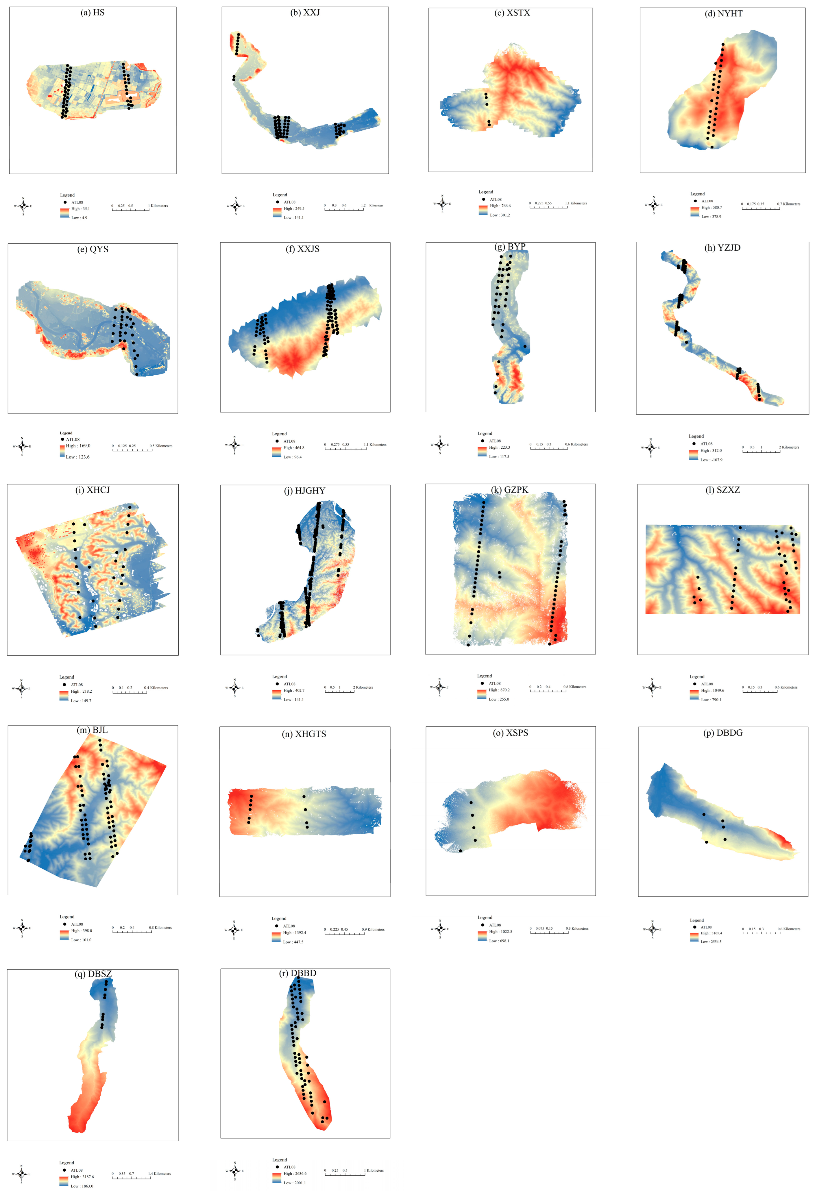
To ensure the reliability of the comparison between ICESat-2 ATL08 terrain elevation and the reference DSM elevation (Figure 2), this study formulated a systematic data matching and preprocessing workflow, which mainly includes three steps: quality filtering, outlier elimination, and spatial interpolation matching.

3.1.1. Preprocessing of ICESat-2 ATL08 Data

To reduce the influence of clouds, noise and other interference on elevation validation results, considering the characteristics of multi-site and large-scale statistical verification in this study, a dedicated data preprocessing workflow was designed as follows:
(1) Removal of invalid and abnormal values
Segments with an invalid flag of ‘h_te_uncertainty’ (e.g., 3.4028235 × 1038) were eliminated. Meanwhile, segments whose ‘terrain_h’ obviously exceeded the reasonable elevation range of the corresponding site (±30 m relative to the reference DEM) were removed as outliers.
(2) Filtering of cloud and atmospheric interference
Based on the ‘cloud_flag_atm’ field, segments with a cloud flag greater than 2 were excluded to mitigate the degradation of laser signal quality caused by clouds and aerosols.
(3) Constraints on photon quantity and ground photon proportion
The ground photon ratio was calculated as ratio_te = n_te_photons/(n_te_photons + n_ca_photons + n_to_photons). Segments with a ratio_te of less than 0.6 were discarded to guarantee the dominance of ground photons. Segments with a total photon number of less than 30 were also removed due to excessive noise or weak signal intensity. This study draws on the classic ATL08 photon filtering scheme proposed by Shang et al. [13] and published in IEEE Transactions on Geoscience and Remote Sensing (TGRS).
It should be noted that the above screening strategy adopts a relatively loose threshold, without setting stricter constraints on terrain slope and land cover. This is mainly because a high-precision DSM was used as the reference elevation in this study. With fine spatial resolution and high vertical accuracy, the DSM can effectively identify and eliminate gross errors and anomalies in ATL08 data. Therefore, moderate preprocessing was sufficient to meet the requirements of subsequent elevation validation while ensuring data quality, avoiding excessive filtering and the loss of valid samples.

3.1.2. Elevation Extraction Method of Reference DSM

Due to the difference in spatial resolution, the latitude and longitude coordinates of ICESat-2 ATL08 do not strictly coincide with the DSM grid points. To eliminate the influence of spatial heterogeneity on validation results, a single-point extraction strategy was adopted in this study. Specifically, the DSM elevation at the center of each ATL08 footprint was directly extracted as the reference value. Considering that the effective footprint diameter of ATL08 is approximately 17 m and the spatial resolution of the DSM is better than 5 m, single-point extraction can fully retain surface details and avoid smoothing errors introduced by multi-pixel averaging. The elevation datum of all validation points is unified to geodetic height. The bilinear interpolation method was employed to extract the DSM elevation corresponding to each ATL08 laser point location.

3.2. Accuracy Evaluation Metrics

This study adopts the following metrics to evaluate the vertical accuracy of the ATL08 product:
(1) Mean Error (ME)
Mean Error is the arithmetic average of the differences between ATL08 elevation and DSM reference elevation, which reflects the systematic bias of ATL08 measurements. Its calculation formula is as follows:
M E = 1 n i = 1 n h A T L 08 ,   i h D S M , i = 1 n i = 1 n h i
where n is the number of check points, h A T L 08 , i denotes the elevation value from ATL08 data, h D S M , i represents the elevation value from DSM data, and h i is the elevation difference of the i-th sample point.
(2) Mean Absolute Error (MAE)
Mean Absolute Error is the arithmetic mean of the absolute difference between ATL08 elevation and DSM reference elevation, reflecting the average magnitude of errors regardless of error direction. Its calculation formula is as follows:
M A E = 1 n i = 1 n h A T L 08 ,   i h D S M , i
(3) Root Mean Square Error (RMSE)
Root Mean Square Error is the square root of the mean squared difference between ATL08 elevation and DSM reference elevation. It is the most commonly used indicator for evaluating overall accuracy and assigns higher weights to large errors. Its calculation formula is as follows:
R M S E = 1 n i = 1 n h A T L 08 ,   i h D S M , i 2
(4) Standard Deviation of Errors (STD)
The standard deviation of errors is the square root of the mean of the squared deviations between individual errors and their mean value. It reflects the dispersion degree of errors or the magnitude of random errors, and is independent of systematic bias. Its calculation formula is as follows:
S T D = 1 n i = 1 n h i h ¯ 2
where h ¯ is the arithmetic mean of elevation differences for all validation points.

4. Results

4.1. Overall Accuracy Statistics

Table 2 summarizes the accuracy evaluation results for the 18 sites. The average RMSE for all sites is 3.318 m, ranging from 1.0444 m (HS) to 5.120 m (XSPS). The overall mean error (ME) is −1.032 m, with site-specific ME values ranging from −4.575 m to +2.548 m. Most sites show negative ME, while two sites (XSTX, ME = +0.090 m; XHGTS, ME = +2.548 m) show positive ME. Given the varying sample sizes across sites, some were as low as 5–10 points.
Plain area (HS): RMSE = 1.04 m, achieving the highest accuracy; ME = −0.694 m, with errors mostly concentrated within ±1 m.
Hilly areas (XXJ, XSTX, NYHT, QYS, XXJS): RMSE ranges from 1.610 m to 3.871 m, with an average RMSE of approximately 2.253 m. XXJ performs the best (RMSE = 1.61 m), while XXJS shows relatively lower accuracy (RMSE = 3.87 m).
Mountainous areas (BYP, YZJD, XHCJ, HJGHY, GZPK, SZXZ, BJL, XHGTS, XSPS): RMSE varies from 2.374 m to 5.120 m, with an average RMSE of about 3.842 m. BYP has the best performance (RMSE = 2.374 m), whereas XSPS exhibits the lowest accuracy (RMSE = 5.120 m).
Alpine canyon areas (DBDG, DBSZ, DBBD): RMSE ranges between 3.702 m and 5.076 m, with an average RMSE of around 4.280 m. DBDG has an RMSE of 3.702 m, and DBBD reaches 5.076 m.
For sites with small sample sizes (e.g., XSTX, n = 5; XSPS, n = 5; DBDG, n = 5; DBSZ, n = 10; XHGTS, n = 10), the derived metrics may be less robust; however, they still provide valuable indications of ATL08 performance in these challenging terrains, especially when compared with other sites of the same terrain type.

4.2. Error Distribution Characteristics

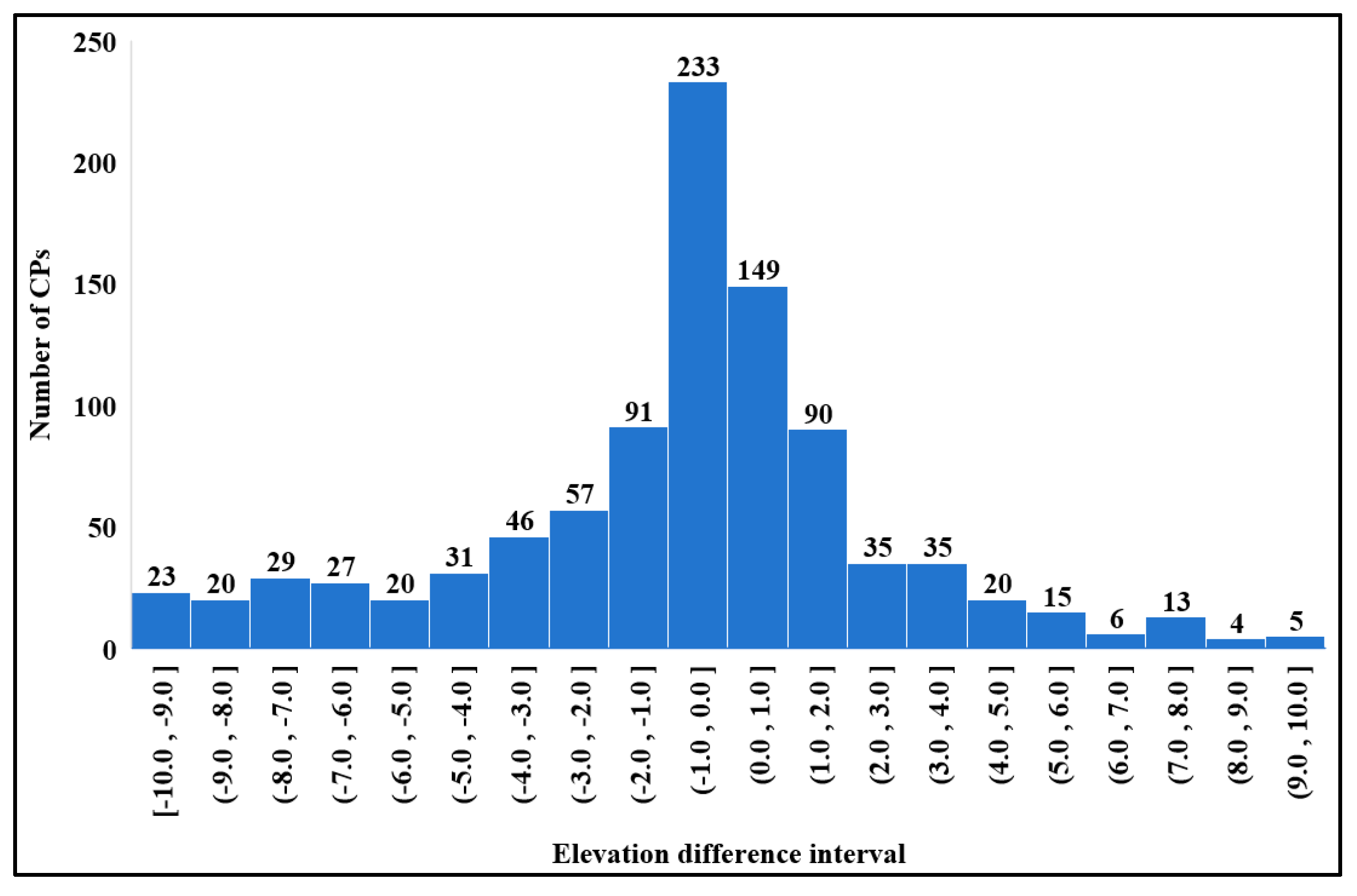
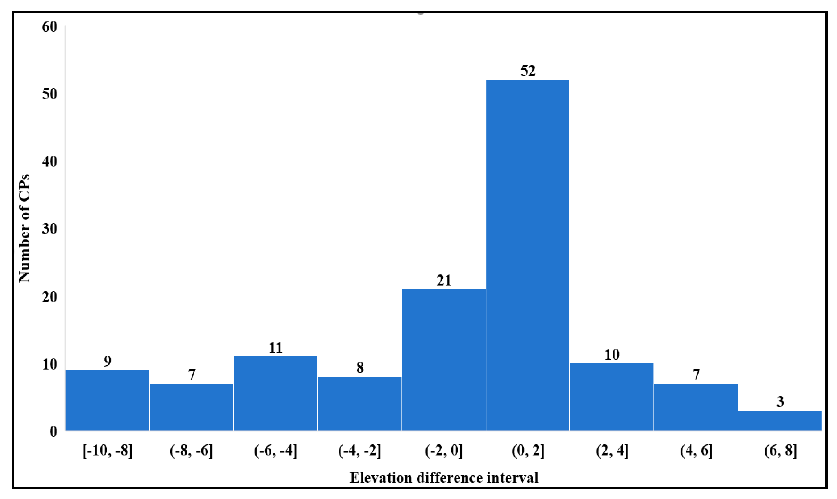
Figure 3 presents the error distribution histogram of all 949 valid sample points. The error distribution approximately follows a normal distribution, with the center concentrated near −0.79 m. Statistical results show that about 82.9% of the points have an absolute error of less than 5 m, and approximately 94.5% are within 8 m. Samples with absolute errors between 8 m and 10 m only account for 5.5% of the total.
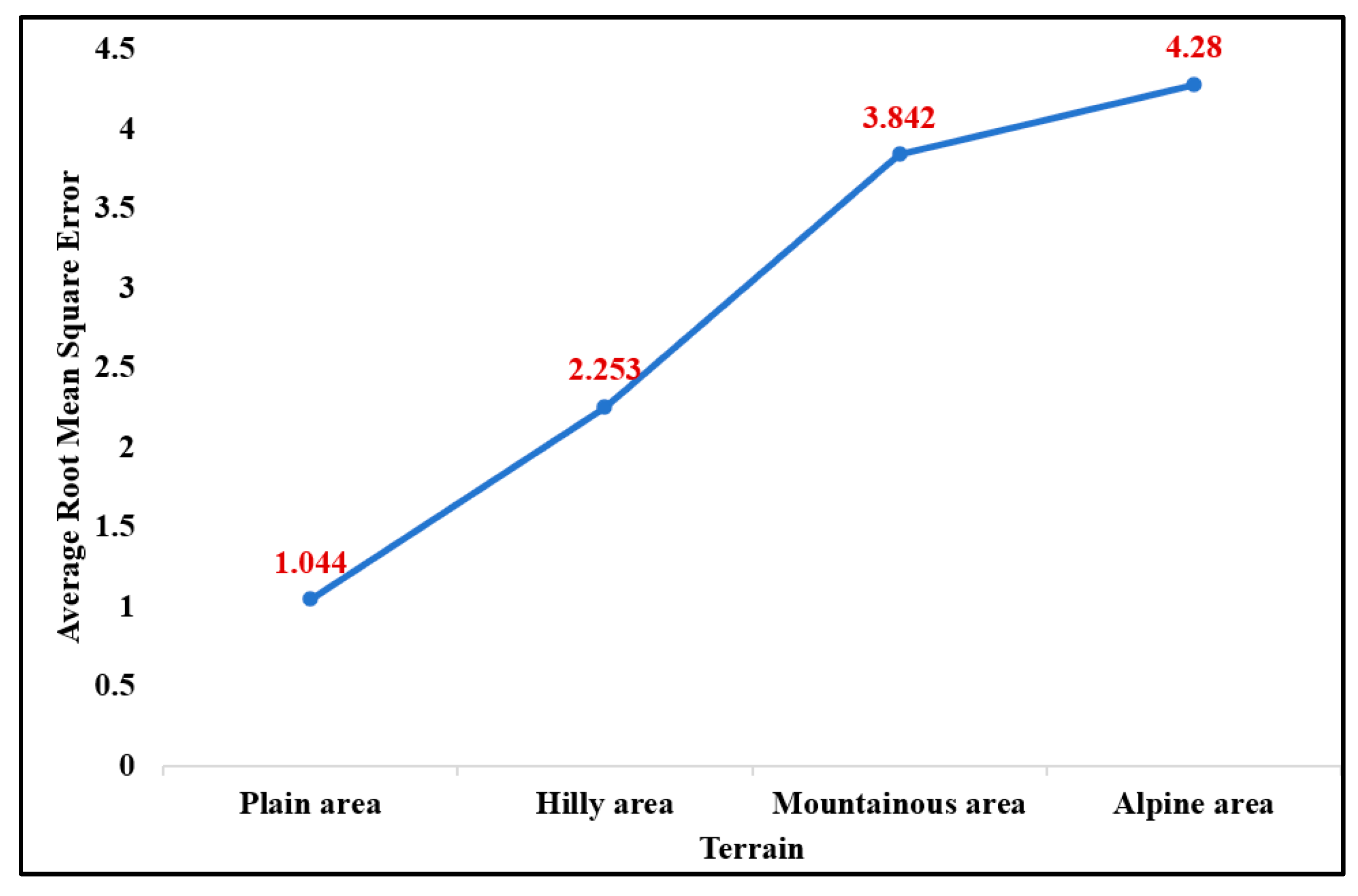
Figure 4 illustrates the variation trend of RMSE across different terrain types. As terrain complexity increases, the RMSE shows a distinct rising trend: the median RMSE is approximately 1.044 m for plain areas, 2.253 m for hilly areas, 3.842 m for mountainous areas, and 4.28 m for alpine canyon areas. This trend indicates that terrain complexity is one of the dominant factors affecting the vertical accuracy of the ATL08 product.
Figure 5 shows the scatter plot of elevation differences between ICESat-2 ATL08 and DSM at the HS site. Its RMSE is only 1.044 m, with an ME of −0.694 m. Located in the Dongting Lake Plain, this site features flat terrain dominated by farmland with low vegetation height. This case indicates that the ICESat-2 ATL08 terrain elevation product can achieve high accuracy in flat areas with low vegetation coverage, and can reliably replace traditional ground surveying methods.
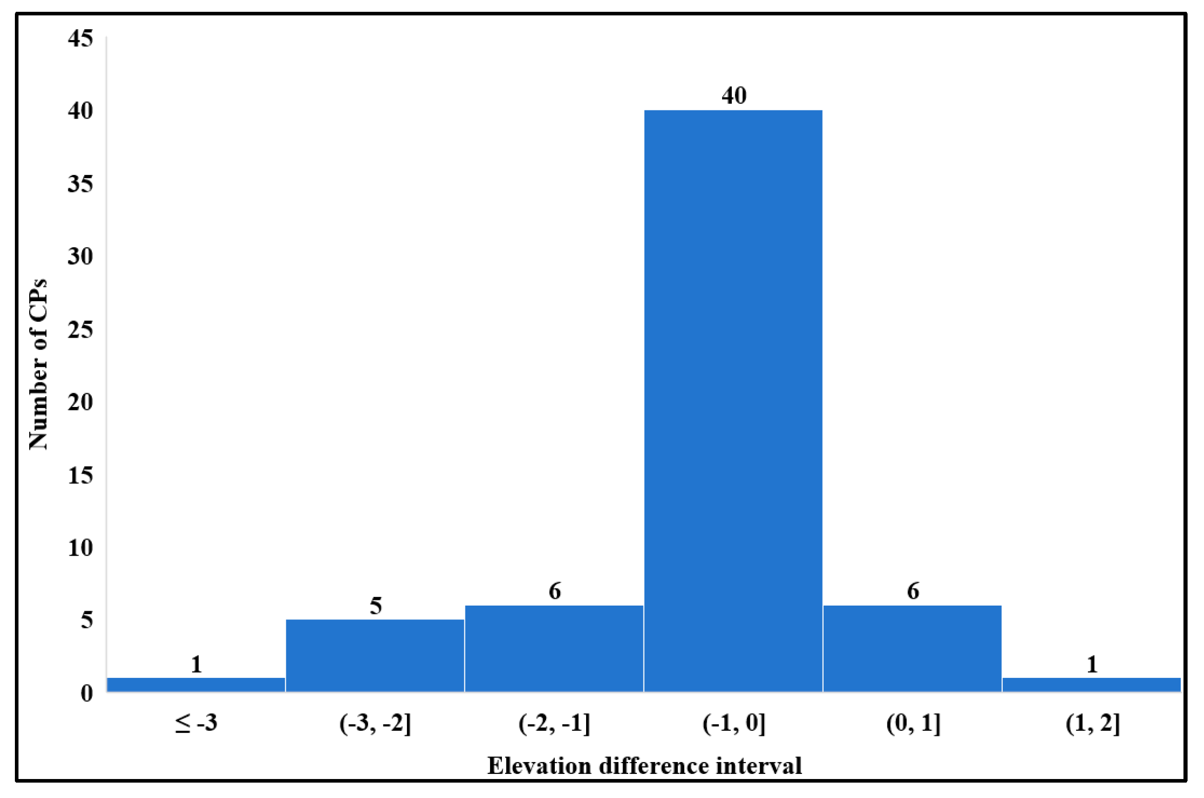
Figure 6 illustrates the spatial distribution of errors at the XXJS site. The RMSE of this site is 3.871 m, which is at the average level for hilly areas. Most sample points have errors within ±5 m, while a small number of discrete points show errors close to 10 m.
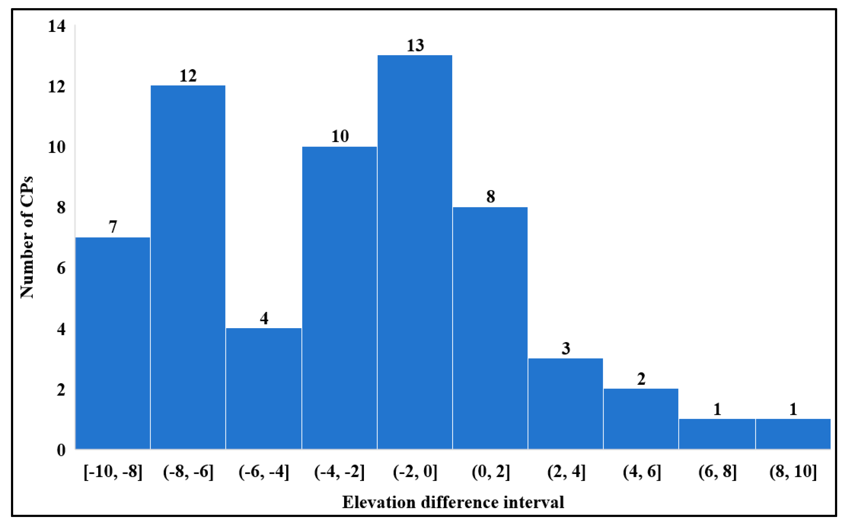
Figure 7 presents the scatter plot of ATL08 elevation versus DSM elevation at the DBBD site. With an RMSE of 5.076 m, this site ranks among the lowest in accuracy across all experimental sites. The scatter plot reveals significantly higher point dispersion compared with plain areas.
DBBD is located in the alpine canyon region of western Sichuan, characterized by steep terrain and dramatic elevation variations ranging approximately from 2000 m to 2600 m. Under such complex topographic conditions, the ground photon recognition of ATL08 faces considerable challenges, resulting in an obvious decline in measurement accuracy.

5. Discussion

5.1. Additional Validation Using GNSS Measurements

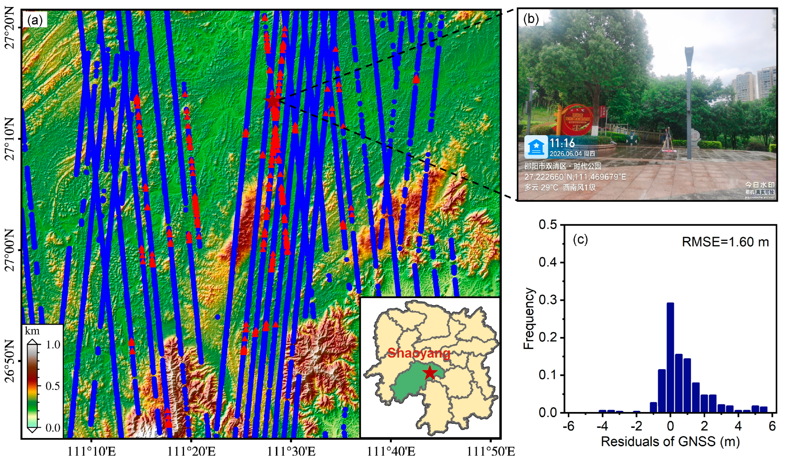
To further validate the accuracy of the ICESat-2 ATL08 terrain height product in central-south China, the Shaoyang region in Hunan Province (111°10′E–111°50′E, 26°40′N–27°20′N) was selected as the validation area. We deployed 343 GNSS control points across the study area to obtain centimeter-accurate ground elevation benchmarks. Field measurements were collected via network RTK, whose horizontal and vertical accuracy both exceeded 0.1 m. Comparing the ATL08 segment center elevations with the co-located GNSS elevations yields an overall RMSE of 1.6 m (Figure 8).
This RMSE lies between the values obtained for plain (1.044 m) and hilly (1.610–3.871 m) sites in our DSM-based validation, which is consistent with the relatively gentle topography and open land cover of the Shaoyang validation area. The result further confirms that ATL08 accuracy degrades with increasing terrain complexity.

5.2. Comparison with Existing Studies

Based on high-resolution DSM, the verification results for the ATL08 terrain elevation product at 18 sites in central and southern China both confirm and supplement existing domestic and international verification conclusions. In flat terrain areas, the RMSE for the plain site (HS) in this study was 1.044 m, which is generally consistent with findings from other studies in low-relief regions [8]. This further confirms that ATL08 exhibits excellent vertical accuracy in low-relief regions.
In mountainous terrain areas, the accuracy range (RMSE: 2.374–5.120 m) of this study is comparable with multiple verification results in China. Zhang et al. [20] verified, in the Maoer Mountain National Forest Park in Northeast China, that the RMSE of the ATL08 strong-beam ground elevation was 1.9 m, and as the slope increased from 0° to more than 20°, the RMSE deteriorated from 2.3 m to 7.7 m. With a larger number of mountainous sites and wider coverage, the RMSE of this study is basically consistent with the slope-related error range reported by them. In more complex mountainous areas, the study by Zhang Yanli et al. [21] provides important reference significance: in the Qilian Mountains, the official ATL08 product (Version 04) had an RMSE of 2.72 m and a mean bias error (MBE) of −1.27 m in mountainous areas with slopes of greater than 20°, which is consistent with the average RMSE (approximately 3.84 m) and overall mean error (ME) (−1.032 m) for the mountainous sites in this study. The RMSE for the alpine canyon sites in this study was higher (3.70–5.08 m), which may be attributed to the fact that the elevation relief and vegetation density in the western Sichuan canyon area were both higher than those in the Qilian Mountains study area, and the dual superposition effect of terrain and vegetation further amplified the errors.

5.3. Analysis of Error Sources

It should be noted that due to the inherent horizontal geolocation errors of the ICESat-2/ATLAS product, even when the reference DSM and laser point coordinates are in the same geodetic reference frame, point-level horizontal misalignment remains unavoidable. The horizontal accuracy of ICESat-2 has been extensively validated in previous studies, with reported horizontal positioning errors on the order of 3.8–4.7 m [2,22]. Such horizontal residuals can be further amplified by terrain slope in undulating landscapes, leading to significant vertical discrepancies. Although our validation method cannot eliminate these inherent errors, it reflects the actual achievable accuracy of the ATL08 product under real-world usage conditions.
To further illustrate the impact of horizontal geolocation errors under different terrain conditions, we added a group-wise accuracy analysis by landform type in this section. The results clearly show that terrain complexity exerts a significant influence on ATL08 elevation accuracy. In alpine canyon sites (e.g., DBBD, RMSE = 5.076 m), the measurement accuracy is only one-fifth of that in the plain site (HS, RMSE = 1.044 m). Grouped by landform type, the average RMSE is 1.044 m for plains, about 2.253 m for hilly areas, roughly 3.842 m for mountainous areas, and 4.280 m for alpine canyons. As terrain complexity increases, RMSE shows a steady, monotonic upward trend. This gradient pattern is consistent with the findings of Osama et al. [23] and Tian and Shan [24], who reported that larger slopes amplify the vertical discrepancies caused by horizontal residuals. The analysis further demonstrates that the impact of horizontal geolocation errors on validation results is itself highly dependent on terrain complexity.
However, terrain complexity alone cannot fully explain all the differences in errors. Both XXJS and XXJ are hilly sites, yet the RMSE at XXJS (3.871 m) is 2.4 times that at XXJ (1.610 m). Their mean errors (ME) are quite close: −0.748 m and −0.688 m, respectively. This comparison suggests that XXJS has a much larger random error (STD = 3.798 m, compared to 1.456 m at XXJ).
To further investigate the causes of the errors, we analyzed land cover types around the validation points using a global 10 m land cover map. We used the Esri 10 m global land cover dataset, which is generated from Sentinel-2 L2A imagery combined with Impact Observatory’s deep learning classification model. This dataset divides the land surface into nine main categories, including trees, built-up areas, bare land, etc. The statistics are shown in the table below (only classes with a proportion >10% are listed). From Table 3, we see that the dominant land cover at XXJ is crops, while at XXJS, it is trees. A likely explanation is that tree-covered areas have greater effective terrain roughness than crop areas, which degrades the elevation accuracy of the ATL08 product.
To further analyze the influence of land cover, we classified the surface types for all 949 validation points (only the main categories are listed). The results are shown in Table 4 below. Crop and water areas tend to give higher accuracy.

6. Conclusions

Based on high-resolution digital surface models (DSM), this study systematically evaluated the accuracy of ICESat-2 ATL08 terrain elevation products. The validation was conducted at 18 sites across four typical geomorphological types in south-central China, including plains, hills, mountains, and alpine canyons, with a total of 949 valid check points. In addition, an independent validation using 343 high-precision GNSS control points (Section 5.1) was carried out, yielding an overall RMSE of 1.6 m in relatively gentle and open terrain. The main conclusions are summarized as follows:
(1) The ATL08 product achieves satisfactory overall accuracy.
The overall average RMSE across all 18 DSM-based validation sites is 3.318 m. The GNSS validation result (1.6 m) is consistent with the accuracy observed in plain and gentle hilly areas, further confirming the reliability of ATL08 in low-relief regions.
(2) Product accuracy exhibits a significant monotonically increasing dependence on topographic complexity.
The vertical accuracy of ATL08 degrades monotonically with rising topographic complexity, showing an evident gradient pattern. Plain areas present the best accuracy (RMSE = 1.044 m, ME = −0.694 m), followed by hilly regions with RMSE ranging from 1.610 to 3.871 m (mean ~2.253 m). Mountainous areas rank third, with RMSE between 2.374 and 5.120 m (mean ~3.842 m), while alpine canyon areas have the lowest accuracy (RMSE: 3.702–5.076 m, mean ~4.280 m). This trend suggests that topographic complexity acts as the primary constraint on ATL08 accuracy. In plain and gentle hilly areas, ATL08 can be directly used as a reliable elevation dataset. By contrast, in mountainous and alpine canyon regions, users should properly recognize its accuracy limitation according to terrain conditions and interpret single-point elevation values with caution.
(3) After strict quality control, ICESat-2 ATL08 performs robustly in south-central China and remains applicable even in complex terrain.
After systematic quality screening and invalid value removal, the RMSE of all 18 sites ranges from 1.044 m to 5.120 m, reflecting stable overall accuracy. Even in the most challenging alpine canyon areas of western Sichuan (Danba sites), the RMSE is maintained within 3.70–5.08 m. The results prove that quality-controlled ICESat-2 ATL08 data still have acceptable applicability in the complex terrain of south-central China, and can serve as an auxiliary data source for terrain analysis and modeling.

Author Contributions

J.C. and W.W. wrote the paper, processed the image data and conducted the experiments. J.L. and Y.G. carried out field GNSS point measurement campaigns. M.D. and G.L. guided the experiments and structure of the paper. All authors have read and agreed to the published version of the manuscript.

Funding

This research was funded by the Nature Science Foundation of Hunan Province (Nos. 2024JJ6411 and 2026JJ80754) and the Nature Science Foundation of Shaoyang City (No. 2024PT6099).

Data Availability Statement

The data presented in this study are available on request from the corresponding author.

Conflicts of Interest

Author Jingqi Liu was employed by the China Construction Huxiang Design Co., Ltd. The remaining authors declare that the research was conducted in the absence of any commercial or financial relationships that could be construed as a potential conflict of interest.

References

  1. Markus, T.; Neumann, T.; Martino, A.; Abdalati, W.; Brunt, K.; Csatho, B.; Farrell, S.; Fricker, H.; Gardner, A.; Harding, D.; et al. The Ice, Cloud, and Land Elevation Satellite-2 (ICESat-2): Science Requirements, Concept, and Implementation. Remote Sens. Environ. 2017, 190, 260–273. [Google Scholar] [CrossRef] [Scilit]
  2. Lian, W.; Zhang, G.; Cui, H.; Chen, Z.; Wei, S.; Zhu, Y. Extraction of High-Accuracy Control Points Using ICESat-2 ATL03 in Urban Areas. Int. J. Appl. Earth Obs. Geoinf. 2022, 115, 103116. [Google Scholar] [CrossRef] [Scilit]
  3. Li, B.; Xie, H.; Tong, X.; Tang, H.; Liu, S. A Global-Scale DEM Elevation Correction Model Using ICESat-2 Laser Altimetry Data. IEEE Trans. Geosci. Remote Sens. 2023, 61, 1–15. [Google Scholar] [CrossRef] [Scilit]
  4. Xie, J.; Zhong, J.; Mo, F.; Liu, Z.; Li, S.; Zeng, J. Denoising and Accuracy Evaluation of ICESat-2/ATLAS Photon Data for Nearshore Waters Based on Improved Local Distance Statistics. Remote Sens. 2023, 15, 2828. [Google Scholar] [CrossRef] [Scilit]
  5. Zhang, G.; Xing, S.; Xu, Q.; Li, P.; Liu, D. A Pre-Pruning Quadtree Isolation Method with Changing Threshold for ICESat-2 Bathymetric Photon Extraction. Remote Sens. 2023, 15, 1629. [Google Scholar] [CrossRef] [Scilit]
  6. Yin, G.; Liu, X.; Meng, W.; Liu, Y.; Zhao, J. Adaptive OPTICS Algorithm Denoising ICESat-2 Laser Photon Data. IEEE Geosci. Remote Sens. Lett. 2024, 21, 1–5. [Google Scholar] [CrossRef] [Scilit]
  7. Neuenschwander, A.; Pitts, K. The ATL08 Land and Vegetation Product for the ICESat-2 Mission. Remote Sens. Environ. 2019, 233, 111380. [Google Scholar]
  8. Neuenschwander, A.; Magruder, L.; Kanaloš, M. Validation of ICESat-2 Terrain and Canopy Heights in Boreal Forests. Remote Sens. 2020, 12, 1156. [Google Scholar]
  9. Wang, C.; Liang, X. Global Validation of ICESat-2 ATL08 Terrain Height Using High-Precision ALS Data. J. Remote Sens. 2023, 3, 0045. [Google Scholar]
  10. Malambo, L.; Popescu, S.C. Assessing the Accuracy of ICESat-2 ATL08 Canopy Height Products across Diverse Ecosystems. Int. J. Appl. Earth Obs. Geoinf. 2021, 99, 102321. [Google Scholar]
  11. Feng, S.; Li, W.; Zhang, Y.; Chen, J.; Wang, H. Evaluation of ICESat-2 ATL08 Terrain and Canopy Height Products with Airborne LiDAR Data in a Complex Mountainous Forest. IEEE Trans. Geosci. Remote Sens. 2023, 61, 1–15. [Google Scholar]
  12. Dandabathula, G.; Sitiraju, S.R.; Jha, C.S.; Rizvi, S.H. Validation of ICESat-2 ATL08 Terrain Height Product over Various Land Cover Types Using DGPS Measurements. Geocarto Int. 2020, 37, 2942–2961. [Google Scholar]
  13. Shang, D.; Zhang, Y.; Dai, C.; Li, G.; Huang, J.; Yin, T. Extraction Strategy for ICESat-2 Elevation Control Points Based on ATL08 Product. IEEE Trans. Geosci. Remote Sens. 2022, 60, 1–12. [Google Scholar] [CrossRef] [Scilit]
  14. Yang, J.; Zheng, H.; Ma, Y.; Liu, R.; Zhang, J. Background Noise Model of Spaceborne Photon-Counting Lidars over Oceans and Aerosol Optical Depth Retrieval from ICESat-2 Noise Data. Remote Sens. Environ. 2023, 299, 113858. [Google Scholar] [CrossRef] [Scilit]
  15. Chang, B.; Xiong, H.; Li, Y.; Guo, R.; Yang, H.; Zhang, K. ALCSF: An Adaptive and Anti-Noise Filtering Method for Extracting Ground and Top of Canopy from ICESat-2 LiDAR Data along Single Tracks. ISPRS J. Photogramm. Remote Sens. 2024, 215, 80–98. [Google Scholar]
  16. Tian, X.; Shan, J. Detection of Signal and Ground Photons from ICESat-2 ATL03 Data. IEEE Trans. Geosci. Remote Sens. 2022, 61, 1–14. [Google Scholar] [CrossRef] [Scilit]
  17. Zhang, X.; Xing, S.; Xu, Q.; Zhang, G.; Li, P.; Liu, D. Satellite Remote Sensing Image Stereoscopic Positioning Accuracy Promotion Based on Joint Block Adjustment with ICESat-2 Laser Altimetry Data. IEEE Access 2021, 9, 113362–113376. [Google Scholar] [CrossRef] [Scilit]
  18. Wang, M.; Wei, Y.; Pi, Y. Geometric Positioning Integrating Optical Satellite Stereo Imagery and a Global Database of ICESat-2 Laser Control Points: A Framework and Key Technologies. Geo-Spat. Inf. Sci. 2023, 26, 206–217. [Google Scholar] [CrossRef] [Scilit]
  19. Liu, X.; Ran, M.; Xia, H.; Deng, M. Evaluating Vertical Accuracies of Open-Source Digital Elevation Models over Multiple Sites in China Using GPS Control Points. Remote Sens. 2022, 14, 2000. [Google Scholar] [CrossRef] [Scilit]
  20. Zhang, C.K.; Yu, Y. Accuracy Verification of Ground Elevation and Vegetation Canopy Height Inversion from ICESat-2/ATLAS Data. For. Eng. 2023, 39, 1–11. [Google Scholar]
  21. Zhang, Y.; Zhao, P.; Li, X.; Yang, B.; Zhao, J.; Hu, J.; Wei, Q.; Li, K.; He, M. Retrieval of terrain surface elevation in mountainous areas with ICESat-2/ATLAS. Remote Sens. Environ. 2025, 327, 114823. [Google Scholar] [CrossRef] [Scilit]
  22. Gao, M.; Xing, S.; Zhang, G.; Zhang, X.; Li, P. Assessment of ICESat-2’s Horizontal Accuracy Using an Iterative Matching Method Based on High-Accuracy Terrains. Remote Sens. 2023, 15, 2236. [Google Scholar]
  23. Osama, N.; Shao, Z.; Ma, Y.; Yan, J.; Fan, Y.; Habib, S.M.; Freeshah, M. The ATL08 as a Height Reference for the Global Digital Elevation Models. Geo-Spat. Inf. Sci. 2024, 27, 327–346. [Google Scholar]
  24. Tian, X.; Shan, J. Comprehensive Evaluation of the ICESat-2 ATL08 Terrain Product. IEEE Trans. Geosci. Remote Sens. 2021, 59, 8195–8209. [Google Scholar] [CrossRef] [Scilit]
Figure 1. Spatial distribution of 18 study areas.
Remotesensing 18 02160 g001
Figure 2. Distribution of ATL08 laser points and DSM.
Remotesensing 18 02160 g002
Figure 3. Error histogram of all validation points.
Remotesensing 18 02160 g003
Figure 4. Variation trend of RMSE of each site with terrain type.
Remotesensing 18 02160 g004
Figure 5. Error histogram of elevation difference between ATL08 and DSM at HS site.
Remotesensing 18 02160 g005
Figure 6. Error histogram of elevation difference between ATL08 and DSM at XXJS site.
Remotesensing 18 02160 g006
Figure 7. Error histogram of elevation difference between ATL08 and DSM at Danba Badi site.
Remotesensing 18 02160 g007
Figure 8. (a) Distribution of GNSS stations, where the red pentagrams represent GNSS sites and blue dots denote ATL08 points; (b) GNSS measurement scenario, corresponding to the location of the red pentagram in (a); (c) histogram of statistical results.
Remotesensing 18 02160 g008
Table 1. Basic information table of the experimental areas.
No.Site NameCodeValid PointsProportion (%)Main Land Cover TypeTerrain Type
1HanShouHS596.2WaterPlain area
2XinXuJiangXXJ778.1CropsHilly area
3XinShaoTanXiXSTX50.5Trees
4NingYunaHeTingNYHT313.3Rangeland
5QiYangShiQYS313.3Crops
6XiangXiangJinShuXXJS12813.5Trees
7BaiYangPingBYP373.9Built AreaMountainous area
8YongZhouJinDongYZJD798.3Trees
9XinHuaCaoJiaXHCJ283.0Crops
10HongJiangGuiHuaYanHJGHY19921.0Built-Area
11GuZhangPaiKouGZPK596.2Trees
12ShanZhouXiZhangSZXZ434.5Trees
13BaJiaoLongBJL828.6Trees
14XinHuaGuTaiShanXHGTS101.1Trees
15XinShaoPingShangXSPS50.5Trees
16DanBaDongGuDBDG50.5TreesAlpine area
17DanBaShuiZiDBSZ101.1Built-Area
18DanBaBaDiDBBD616.4Trees
Note: Sites with fewer than 20 valid points (e.g., XSTX, XHGTS, XSPS, DBDG, DBSZ) have limited statistical representativeness. Their accuracy metrics are presented for completeness of terrain coverage, but should be interpreted with caution and in conjunction with other sites of the same terrain type.
Table 2. Accuracy statistics of ICESat-2 ATL08 at each site.
No.CodeRMSE
(m)
ME
(m)
MAE
(m)
STD
(m)
Terrain Type
1HS1.044−0.6940.7600.780Plain area
2XXJ1.610−0.6880.8221.456Hilly area
3XSTX1.7480.0901.5911.746
4NYHT1.876−0.8861.5161.654
5QYS2.159−0.8591.0681.980
6XXJS3.871−0.7482.7363.798
7BYP2.374−1.2381.4502.026Mountainous area
8YZJD3.155−0.1352.2663.152
9XHCJ3.219−1.7752.0092.685
10HJGHY3.993−0.6203.0473.944
11GZPK4.091−0.4912.9994.060
12SZXZ4.108−0.3703.2904.091
13BJL4.259−0.4543.0704.235
14XHGTS4.2602.5483.2623.415
15XSPS5.120−4.5754.5752.300
16DBDG3.702−2.2542.6512.937Alpine area
17DBSZ4.062−2.7692.9362.973
18DBBD5.076−2.6514.0504.329
Total3.318−1.032--
Table 3. Land Cover Type Distribution in Validation Area.
CodeWaterTreesCropsBuilt AreaRangeland
HS34 (57.63%)-24 (40.68%)--
XXJ--58 (75.32%)19 (24.68%)-
XSTX-5 (100%)---
NYHT-6 (19.35%)--21 (67.74%)
QYS--25 (80.65%)4 (12.9%)-
XXJS-78 (60.94%) 43 (33.59%)-
BYP-4 (10.81%)13 (35.14%)18 (48.65%)-
YZJD25 (31.65%)34 (43.04%)-17 (21.52%)-
XHCJ--9 (32.14%)7 (25%)8 (28.57%)
HJGHY-74 (37.19%)-108 (54.27%)-
GZPK-54 (91.53%)---
SZXZ-39 (90.7%)---
BJL-43 (52.44%)9 (10.98%)18 (21.95%)-
XHGTS-10 (100%)---
XSPS-5 (100%)---
DBDG1 (20%)2 (40%)-1 (20%)1 (20%)
DBSZ---5 (50%)5 (50%)
DBBD-28 (45.9%)--23 (37.7%)
Table 4. Validation Results for Verification Points of Different Land Cover Types.
Land Cover TypeNumber of PointsRMSE (m)
Water682.307
Trees3864.637
Crops1561.451
Built Area2462.725
Rangeland694.294
Disclaimer/Publisher’s Note: The statements, opinions and data contained in all publications are solely those of the individual author(s) and contributor(s) and not of MDPI and/or the editor(s). MDPI and/or the editor(s) disclaim responsibility for any injury to people or property resulting from any ideas, methods, instructions or products referred to in the content.