Article

Lightweight and Accurate Forest Canopy Segmentation and Cover Estimation via Text-Prompted Pre-Annotation


1
College of Information Technology, Jilin Agricultural University, Changchun 130118, China
2
College of Humanities, Jilin Agricultural University, Changchun 130118, China
3
Northeast Institute of Geography and Agroecology, Chinese Academy of Sciences, Changchun 130102, China
*
Author to whom correspondence should be addressed.
Remote Sens. 2026, 18(11), 1767; https://doi.org/10.3390/rs18111767
Submission received: 5 April 2026 / Revised: 22 May 2026 / Accepted: 26 May 2026 / Published: 1 June 2026
(This article belongs to the Section Forest Remote Sensing)

Highlights

What are the main findings?
  • A human–machine collaborative pre-annotation paradigm driven by Grounding DINO was proposed, completely eliminating the reliance on manual pixel-wise tracing and constructing high-quality tree crown datasets with minimal manual cost.
  • A custom lightweight network (LGBU-Net) tailored for dense forests was developed. With merely 4.85 M parameters, it effectively overcomes semantic confusion and boundary adhesion, achieving high-precision individual tree extraction (IoU: 90.45%) and accurate canopy cover (CC) inversion.
What are the implications of the main findings?
  • It breaks the accuracy and computational bottlenecks of generic large vision models during direct inference in dense forests, providing a practical solution for real-time edge deployment on resource-constrained UAV nodes.
  • It provides a highly accurate and cost-effective technological pathway for large-scale forest resource surveys, significantly broadening the practical applications of individual-tree biomass estimation and dynamic understory light environment monitoring.

Abstract

Traditional high-precision canopy segmentation heavily relies on tedious pixel-level manual annotation, while general-purpose zero-shot visual detection algorithms are prone to boundary adhesion and excessive computational load in dense forest areas. To address this, this study proposes a human–machine collaborative, efficient canopy segmentation and canopy cover inversion paradigm, combining the zero-shot pre-annotation capabilities of text-driven object detection with the high-precision segmentation advantages of the lightweight proprietary network LGBU-Net. In the offline annotation stage, this method automatically locates candidate canopy regions using Grounding DINO combined with text prompts and generates initial pixel-level masks using SAM. A high-quality training set is then constructed through minimal manual correction, significantly reducing the cost of traditional fully manual annotation. Subsequently, an improved LGBU-Net designed for complex forest conditions is used for supervised learning. In the feature extraction stage, a lightweight phantom-coordinate attention module (LG-CAM) is introduced to enhance the network’s focus on the geometric center of the tree canopy and suppress semantic interference caused by the forest background, light spots, and shadows. In the decoding stage, a boundary difference fusion module (BDF-Block) is deployed to alleviate the problem of adjacent tree canopy boundaries adhering by utilizing high-frequency gradient information from the underlying layers of UAV imagery. Combined with a boundary-aware hybrid loss function, the clarity of individual tree boundaries is further improved in the gradient domain. Experiments based on UAV imagery of high-density mixed and coniferous forests in Baishan, Jilin Province, show that, with low manual annotation costs, LGBU-Net achieves a canopy segmentation IoU of 90.45% and an individual tree separation F1 score of 89.35%, significantly outperforming general visual algorithms with zero-shot direct inference, and with only 4.85 M model parameters. Furthermore, the segmentation results are used for plot-level canopy vertical cover (CC) inversion, and the estimated values are highly consistent with ground-based measurements. This research provides a high-precision, low-annotation-cost technical solution with good edge deployment potential for large-scale forest resource surveys and forest understory light environment assessment.

1. Introduction

The forest canopy is a crucial interface for material and energy exchange in terrestrial ecosystems. Accurately extracting tree crown outlines is fundamental to forest biomass estimation, understory habitat assessment, and the high-precision retrieval of canopy cover [1]. The widespread application of unmanned aerial vehicle (UAV) remote sensing has facilitated the acquisition of high-resolution forest orthomosaics [2]. This provides crucial data support for the quantitative retrieval of forest canopy cover. However, in natural forests with high canopy cover, crown distributions are highly complex [3]. Branches and leaves of adjacent trees frequently intertwine and occlude each other [4]. Consequently, precise individual-tree segmentation and subsequent accurate CC estimation remain challenging.
Fully supervised deep learning methods are currently prevalent in remote sensing image segmentation [5]. By learning from massive sample features, these approaches achieve high pixel-level classification accuracy. For example, classical convolutional neural networks (e.g., U-Net, Mask R-CNN) and recent vision transformers have demonstrated overall accuracies above 90% on specific localized forest datasets. However, their performance heavily relies on finely annotated manual masks. In forestry scenarios, constructing large-scale tree crown datasets is exceptionally time-consuming and prone to subjective biases [6]. Such heavy reliance on extensive samples limits the generalization ability and deployment potential of traditional models in cross-regional monitoring tasks [7].
Recently, the development of open-vocabulary and zero-shot object detection technologies (e.g., Grounding DINO) has offered new perspectives for reducing annotation costs. Pre-trained on massive datasets, these algorithms exhibit strong text-driven localization and generalization capabilities. Nevertheless, directly applying these general-purpose vision models to tree crown segmentation presents distinct limitations [8]. For instance, while the Segment Anything Model (SAM) exhibits remarkable zero-shot segmentation capabilities in natural scenes, it frequently fails when attempting to delineate or “penetrate” intricate tree crowns. This failure primarily occurs because SAM’s region-growing and grouping mechanisms heavily rely on distinct edge gradients and homogeneous spatial continuity. In dense forests, the fractal-like nature of leaves, irregular shadows within canopy gaps, and the severe boundary adhesion between intertwining branches disrupt these visual cues. Lacking forestry-specific topological priors and 3D structural awareness, SAM struggles to differentiate interlocking branches, frequently resulting in either the over-segmentation of a single crown into fragmented foliage patches or the under-segmentation of adjacent trees into a single connected mass. Furthermore, their massive parameters and high computational demands complicate direct deployment on resource-constrained UAV edge computing nodes [9], hindering the high-precision retrieval of macroscopic forest parameters [10].
Consequently, a human–machine collaborative approach has emerged as a promising breakthrough. This strategy combines the efficiency of text-driven pre-annotation with the specialized feature extraction capabilities of lightweight networks [11]. It utilizes zero-shot detection algorithms to rapidly generate initial target regions, followed by minimal manual correction. This process drastically reduces the cost of constructing high-quality datasets [12]. Meanwhile, when processing UAV imagery of closed-canopy forests, conventional lightweight networks still face two major spatial challenges [13]. First, variable illumination creates dark canopy gaps and highlights understory weeds, often leading to semantic confusion. Second, the dense intertwining of branches and leaves causes severe boundary adhesion between individual trees, making them difficult to separate [14]. Therefore, a critical issue in fine-grained canopy segmentation remains unresolved: how to enhance the robustness of lightweight networks against complex forest disturbances and accurately delineate individual physical boundaries, all while maintaining low annotation costs [15].
To address these challenges, this study proposes a novel framework for canopy extraction and CC retrieval. The framework integrates zero-shot human–machine collaborative pre-annotation with a lightweight, high-precision segmentation network (LGBU-Net). Specifically, the framework first employs Grounding DINO [16] with text prompts to automatically locate candidate crown regions. The Segment Anything Model (SAM ViT-H version) [17] is then used to generate initial masks. Recognizing SAM’s inherent limitations in separating intertwined branches, minimal manual refinement is applied to these initial masks to correct over-segmented and under-segmented boundaries, thereby efficiently constructing accurate pixel-level training labels. This approach replaces the traditional, labor-intensive process of manual pixel-by-pixel delineation across entire images [18]. Subsequently, LGBU-Net is deployed for domain-specific feature learning and fine-grained segmentation [19].

2. Materials and Methods

2.1. Overview of the Study Area

The study area is located in Hunjiang District, Baishan City, Jilin Province. According to the Geospatial Data Cloud platform (https://www.gscloud.cn/), the site lies between 126°45′E–126°49′E and 42°14′N–42°20′N, with an elevation ranging from 600 to 1200 m. The total area of the data collection is approximately 2.5 square kilometers. The primary vegetation types are coniferous–broadleaf mixed forests and broadleaf mixed forests [20]. The canopy layers are highly complex, exhibiting a wide range of canopy cover (0.40 to 0.95). Notably, these forest types account for over 70% of the forested area in Northeast China. Although geographically concentrated, the study area exhibits extremely high spatial heterogeneity and diverse canopy morphologies [21]. It encompasses various typical scenarios of branch occlusion and canopy overlap that are characteristic of temperate forests. Such complex forest stand conditions provide a challenging testing ground for evaluating the robustness of the segmentation model [22]. Additionally, the site includes several pure coniferous forest plots. This inclusion facilitates a comprehensive evaluation of the model’s generalization ability across different forest stand structures [23]. Furthermore, given the widespread distribution of understory cash crops in this region, accurately quantifying canopy cover holds significant practical value. This is crucial for large-scale vegetation surveys [24].

2.2. Data Acquisition

2.2.1. UAV Remote Sensing Data

To acquire the experimental data, UAV flights were executed in July 2025. This timing corresponded to the peak growing season of the trees, characterized by full leaf expansion, which simultaneously aligned with the main growth stage of the local understory crops [25]. To minimize motion blur caused by swaying branches, all flights were performed under clear skies and calm wind conditions [26]. The specifications of the UAV equipment are detailed in Table 1.
During post-processing, Agisoft Metashape software (version 2.0.1) and the Structure from Motion (SfM) [27] algorithm were utilized. The acquired images underwent aerial triangulation and image stitching to generate the Digital Orthophotography Map (DOM) of the study area [28]. Because the primary objective of this study focuses on canopy structure extraction, and the plot coordinates were provided by relevant authorities, the onboard GNSS data of the UAV were directly used for georeferencing [29]. During the image alignment stage, the processing accuracy was set to “High”. The final average reprojection error was measured at only 0.5 pixels, demonstrating excellent internal geometric consistency within the stitched imagery. The final output DOM achieved a spatial resolution better than 1.5 cm (hereafter referred to as “high-resolution”). This spatial resolution fully satisfies the requirements for subsequent fine-grained canopy feature extraction [30].

2.2.2. Field Measurement and Accuracy Verification

To validate the accuracy of the UAV-based retrievals, synchronous ground-truth measurements were conducted simultaneously with the UAV flights [31]. Field data collection primarily relied on hemispherical photography. A digital camera equipped with a fisheye lens was positioned 1.5 m above the ground at the center and representative locations of each plot [32]. The lens was oriented vertically upward to capture canopy images. According to the forestry department’s standards, the area of each sample plot is 10 m × 10 m.
Notably, canopy cover derived from conventional hemispherical photography often includes occlusion from branches at oblique viewing angles [33]. In contrast, UAV orthomosaics capture canopy cover in a strict vertical projection. Given the fundamental differences in their spatial observation geometries, a field-of-view (FOV) constraint method was introduced to align the two metrics [34]. Specifically, during the analysis of the fisheye images using dedicated image processing software, the effective calculation area was strictly restricted to a central disk region corresponding to a zenith angle θ ∈ [0°, 30°] (denoted as Ω 0 30 ). Image binarization was applied to this restricted region to extract the near-zenith canopy hemispherical percentage ( C H P 0 30 ) using the following equation:
C H P 0 30 = N c a n o p y ( Ω 0 30 ) N t o t a l ( Ω 0 30 )
where N c a n o p y ( Ω 0 30 ) represents the number of vegetation pixels within the restricted FOV, and N t o t a l ( Ω 0 30 ) is the total number of pixels within the same region. The resulting C H P 0 30 closely approximates true vertical cover in its spatial geometric characteristics. Therefore, it was established as the ground-truth benchmark to validate the extraction results from the UAV orthomosaics [35].
To avoid conceptual confusion in subsequent discussions regarding UAV orthomosaics, the term “canopy cover” is uniformly defined as canopy cover [36]. Correspondingly, the ground-based C H P 0 30 calculated with the restricted zenith angle shares the same geometric connotation. Thus, it is designated as the observed ground truth ( C C o b s ) to evaluate the accuracy of the model’s predictions ( C C p r e d ).

2.3. Data Processing

The raw RGB images acquired by the DJI Mini 4 Pro UAV possess a high spatial resolution (4032 × 2268 pixels). Feeding these entire images directly into deep learning networks often causes out-of-memory errors and hinders the extraction of fine-grained local features. Furthermore, to achieve precise tree crown segmentation and improve annotation efficiency, this study cascades Grounding DINO with the Segment Anything Model (SAM). This cascaded framework locates candidate targets and generates initial masks to facilitate subsequent pixel-level labeling. Finally, manual refinement is applied to these initial outputs to construct a reliable dataset for supervised training.

2.3.1. Data Partitioning and Preprocessing

To objectively evaluate model performance and mitigate data leakage caused by spatial autocorrelation in remote sensing imagery, the dataset was initially split at the raw image level rather than the patch level. The raw 4032 × 2268-pixel images acquired by the DJI Mini 4 Pro were randomly divided into training, validation, and test sets in an 8:1:1 ratio. Because the original image size was large, a sliding window non-overlapping cropping strategy was then applied to each subset, with the window size set to 512 × 512 pixels. This size was selected to minimize the truncation of tree crowns at the patch boundaries, thereby preserving their morphological integrity. After cropping, invalid patches containing exclusively background pixels (e.g., bare soil, roads, or non-vegetated areas) were discarded to alleviate class imbalance. This preprocessing workflow yielded a total of 1680 valid patch samples. Specifically, the training set comprises 1344 patches (80%) for model parameter updating and feature fitting. The validation set contains 168 patches (10%) for hyperparameter tuning and triggering the early stopping strategy. The test set consists of the remaining 168 patches (10%), which serve as independent, unseen data for the final accuracy evaluation.

2.3.2. Efficient Tag Construction Based on Human–Machine Collaboration

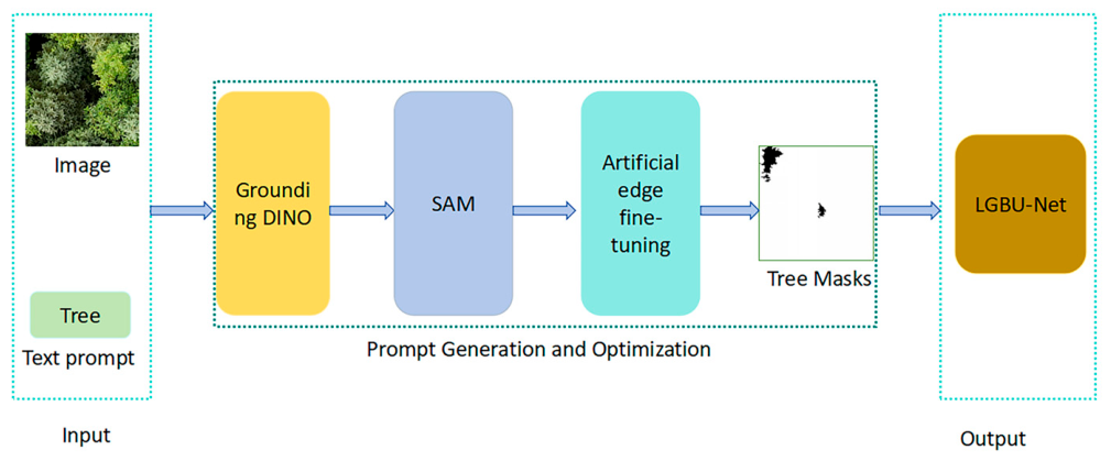
To reduce the pixel-level annotation cost of high-resolution UAV images while ensuring boundary quality for supervised training, this study developed a human-in-the-loop label generation workflow. This workflow consists of text-driven target pre-localization, initial mask generation, and local manual refinement. In this pipeline, Grounding DINO provides spatial priors for tree crown candidate regions. SAM then generates initial pixel-level masks constrained by these candidate bounding boxes. This approach replaces the most time-consuming steps of traditional manual annotation, namely full-image target searching and from-scratch delineation. Compared to completely manual annotation (which takes approximately 5 min per image), using SAM to assist in generating the initial mask, followed by manual correction, reduces annotation time to approximately 2 min per image, lowering costs by 60%.
Specifically, the cropped 512 × 512-pixel RGB patches were first fed into the pre-trained Grounding DINO model. Zero-shot detection was then executed using “tree” as the text prompt. Initial bounding boxes for tree crown candidates were automatically generated by setting appropriate box confidence and text matching thresholds. Overlapping detections were subsequently filtered using Non-Maximum Suppression (NMS) to eliminate redundant candidate regions.
The bounding boxes output by Grounding DINO were then utilized as prompt inputs for SAM to generate the corresponding initial tree crown masks. However, adjacent tree crowns in dense forest areas frequently exhibit occlusion, overlapping, and morphological adhesion. Consequently, the automatically generated initial masks may still suffer from overly smoothed boundaries, local misclassifications, or the merging of adjacent connected components. To address this, annotators performed manual refinement on the initial masks. This step focused on fitting tree crown boundaries accurately, separating adhered adjacent canopies, and removing falsely detected regions.
Following manual revision, quality control was conducted using connected component area analysis and morphological constraints. Mislabeled objects that were excessively small or geometrically deviated from typical tree crown features were removed. Ultimately, high-quality binary labels strictly paired with the UAV image patches were constructed. It is important to note that Grounding DINO and SAM were exclusively utilized during the offline training data construction phase. They were not involved in the subsequent training or the forward computation during the deployment and inference of the LGBU-Net. Therefore, the model parameters and FLOPs reported in this study apply solely to the finally deployed LGBU-Net segmentation network.

2.3.3. Quantitative Estimation of Forest Canopy Cover Based on Segmentation Mask

Prior to the quantitative calculation, a mild connected-component post-processing was applied to the output masks. This step aims to remove isolated noise caused by tiny canopy gaps, ensuring compliance with the definition of continuous cover in forestry [37]. This procedure effectively filters micro-scale misclassification noise and smooths tree crown outlines. Consequently, it further enhances the accuracy of subsequent parameter retrieval. The mathematical expression for vertical canopy cover is defined as follows:
C C = N c a n o p y N t o t a l
where N c a n o p y represents the cumulative number of pixels identified as the canopy foreground within a specific Region of Interest (ROI), and N t o t a l denotes the total number of valid pixels within that same ROI.
Following the spatial alignment rationale established in Section 2.2.2, the CC variable extracted via this method physically corresponds well with the ground-measured near-zenith canopy hemispherical percentage ( C H P 0 30 ). Therefore, it serves as a reliable proxy for representing the actual forest canopy cover. Furthermore, this evaluation framework exhibits strong scale adaptability [38]. On the one hand, precise calculations can be executed within local ROIs that match the ground survey plots. This facilitates rigorous ground-truth validation. On the other hand, combined with a multi-scale sliding window mechanism, the framework can traverse the entire orthomosaic [39]. This enables the generation of continuous spatial distribution maps of canopy cover. This capability provides a novel perspective for intuitively revealing the local spatial heterogeneity of forest stand structures.
In summary, the pixel-ratio retrieval method, driven by high-precision network masks, effectively circumvents the inherent limitations of traditional manual operations. It avoids both the excessive time consumption and the interference of subjective bias. Consequently, it establishes a quantification paradigm for canopy cover that is both computationally efficient and highly reproducible. This approach not only provides a new pathway for the automated monitoring of ecological parameters in local forests. It also constructs a high-resolution data foundation for the fine-grained assessment of understory crop habitat suitability, demonstrating substantial practical value for forestry applications [40].

2.3.4. Data Augmentation and Standardization

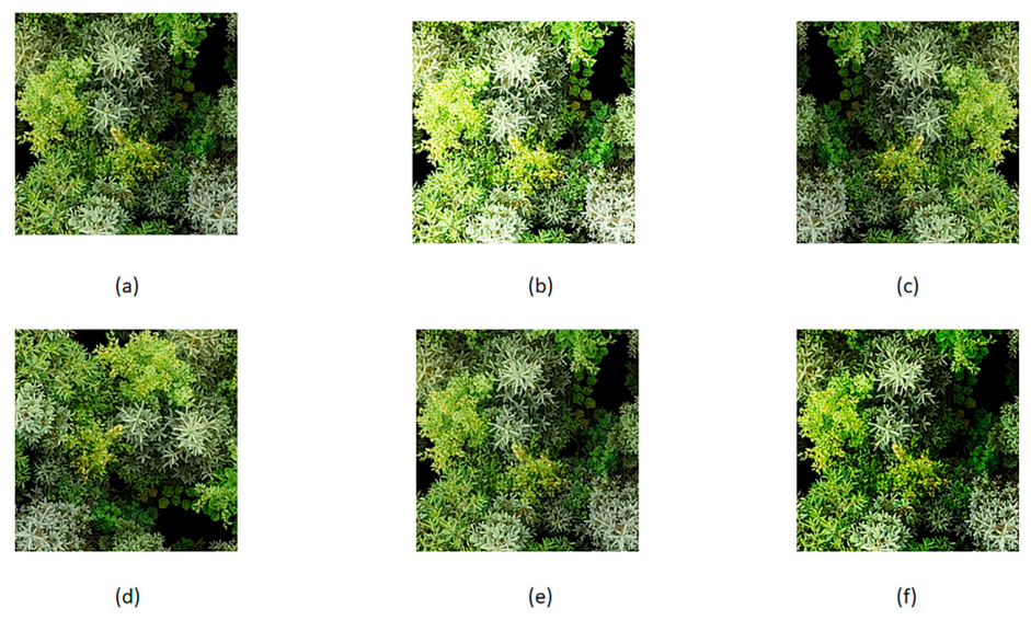
The acquired forest orthomosaics frequently exhibit illumination variations and slight distortions due to field weather conditions and UAV sensor characteristics. To enhance model generalization, spatial and pixel-level data augmentation strategies were applied to the 1344 base samples in the training set. The validation and test sets retained their original data distributions. In the spatial dimension, the rotational invariance of orthophotos was leveraged. Orthogonal rotation (90°) and horizontal flipping were applied simultaneously to the image patches and their corresponding masks. This approach mitigates biases related to flight trajectory orientation while preserving the physical topology of the tree crowns. In the pixel dimension, color jittering (adjusting brightness by 90% and contrast by 80%) was applied to the RGB inputs. This simulates variations in forest light flecks and shadows caused by cloud cover and changes in the solar elevation angle. Additionally, motion blur and Gaussian noise were introduced with a 15% probability. This step simulates the dynamic blurring of branches and leaves under natural wind conditions, as well as the electronic noise generated by sensors in low-light areas [41]. These strategies force the network to reduce its reliance on shallow color features and focus more on the morphological structures and boundary characteristics of tree crowns. Through these procedures, the sample size of the training set was effectively expanded. The data augmentation operations are illustrated in Figure 1.
Before being fed into the network, all images across the training, validation, and test sets were standardized. Specifically, Z-Score normalization was applied to linearly scale the pixel values of the three RGB channels, transforming them into a distribution with a mean of 0 and a standard deviation of 1. The calculation is formulated as follows:
x c = x c μ c σ c
where x c represents the original pixel value of channel c , while μ c and σ c denote the mean and standard deviation of channel c across the dataset, respectively. This standardization process accelerates the convergence of gradient descent and helps mitigate the issues of vanishing or exploding gradients during model training.

2.4. Overall Model Architecture

In tree crown segmentation for high-precision canopy cover estimation, current methodologies face the dual challenges of high manual annotation costs and the limited practical deployment of detection algorithms in complex forests. Traditional fully supervised methods rely heavily on fine, pixel-wise manual masks, making the acquisition of large-scale forestry inventory data highly expensive. Although direct inference with vision segmentation models can eliminate the data annotation process, their massive computational overhead restricts real-time deployment on UAV edge devices. Furthermore, lacking specific prior knowledge of forest morphology, these algorithms often erroneously merge adjacent intertwined tree crowns in dense, closed-canopy forests. Consequently, they struggle to directly provide reliable, fine-grained geometric representations of individual trees.
To address these challenges, this study proposes a novel segmentation paradigm: “intelligent pre-annotation + manual refinement + high-precision learning via a lightweight network” (Figure 2).
As detailed in Section 2.3.2, this study initially employed a text-driven algorithm to automatically generate spatial priors for tree crown candidates. SAM was then utilized to produce initial masks, significantly reducing the cost of manual searching. Subsequent manual fine-tuning efficiently yielded a high-quality, high-precision dataset for supervised network training. However, even with reliable ground-truth labels, directly applying conventional lightweight segmentation networks to high-resolution UAV images faces two physical spatial challenges in complex natural forests. First, closed-canopy forests frequently exhibit complex light scattering and occlusion. Dark shadows in canopy gaps and homogeneous green understory vegetation can easily cause semantic confusion and background misclassification within the network. Second, in mixed stands with intertwined tree crowns, conventional networks often lose fine boundary features during continuous downsampling operations. This loss inevitably leads to edge adhesion in the predicted individual tree masks. Therefore, to accurately retrieve forest canopy cover, it is crucial to design a specialized, computationally efficient network architecture that can mitigate interference from complex habitats and sharpen the gap features between actual tree crowns.
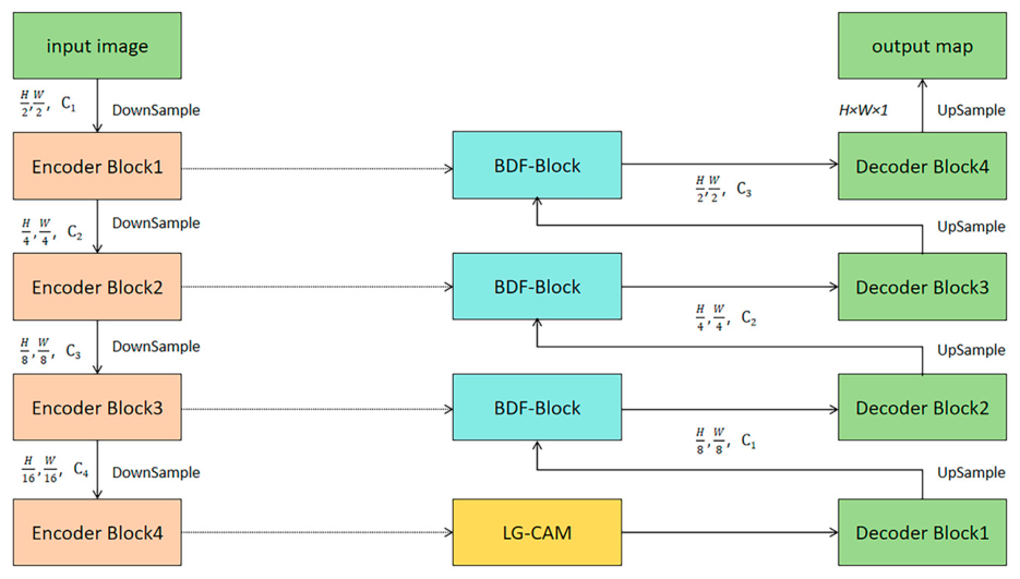
To address these issues, this study proposes LGBU-Net (Lightweight Ghost-Boundary U-Net). Built upon a lightweight backbone, this specialized network is designed for the fine-grained segmentation of individual trees and exhibits robust adaptability to diverse forest conditions (Figure 3).
Specifically, the Lightweight Ghost-Coordinate Attention Module (LG-CAM) is embedded into the core stages of the MobileNetV3 encoder. This module steers the network’s receptive field toward the geometric centers of tree crowns, thereby mitigating background interference from understory shadows and weeds. Along the skip connection paths of the decoder, the Boundary Differential Fusion Block (BDF-Block) is introduced. This block extracts low-level, high-frequency physical gradients from the high-resolution images, forcing the network to preserve sharp, interlaced branch edges within the deep semantic features. Finally, the model is optimized using a boundary-aware hybrid loss, which imposes strict optimization constraints on boundary morphology in the gradient domain. Once trained and deployed, LGBU-Net efficiently generates accurate individual tree masks in complex real-world forests with low computational overhead.
It is important to clarify that the proposed framework consists of two stages: offline label construction and online segmentation inference. During the offline stage, Grounding DINO automatically provides spatial priors for tree crown candidates, while SAM generates initial masks guided by these bounding boxes. This assists human annotators in rapidly creating pixel-level labels. Once high-quality labels are acquired, LGBU-Net undergoes supervised training as the final segmentation model. During the subsequent online inference and deployment stage, Grounding DINO and SAM are no longer utilized. Instead, test image patches are fed directly into LGBU-Net to predict tree crown masks. Consequently, all discussions regarding model parameters, FLOPs, and edge deployment potential in this study apply solely to LGBU-Net.

2.4.1. Lightweight Ghost-Coordinate Attention Module (LG-CAM)

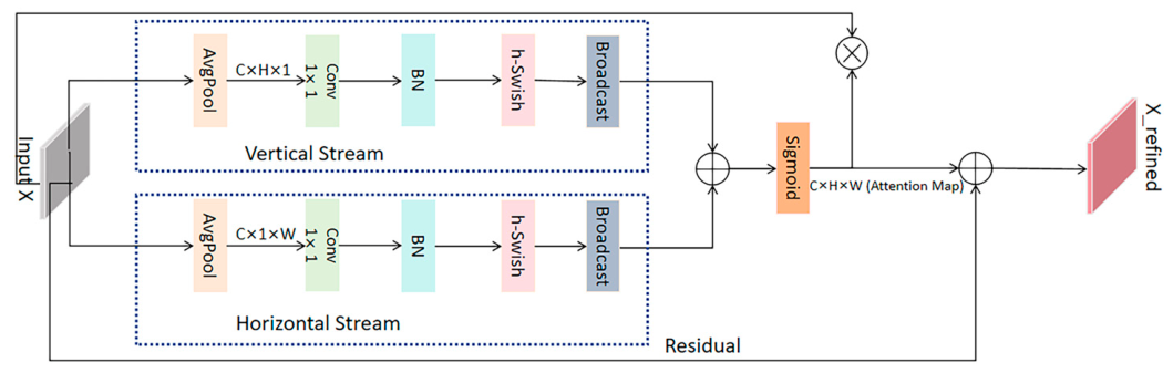
In high-resolution orthomosaics of closed-canopy forests, dark shadows in canopy gaps caused by illumination changes and homogeneous green understory vegetation frequently cause semantic confusion and background misclassification in conventional segmentation networks. To enhance the network’s perception of the core regions of actual tree crowns and suppress interference from non-target backgrounds, the Lightweight Ghost-Coordinate Attention Module (LG-CAM) is embedded into the feature extraction stage. As illustrated in Figure 4, this module aims to improve the localization accuracy of individual tree targets and strengthen feature robustness against interference. It achieves this by enhancing the spatial directionality of the extracted features while maintaining a low computational load.
Traditional channel attention mechanisms (e.g., SE-Block) compress spatial information into a single scalar via global pooling. When processing densely arranged forest canopies, this approach frequently loses the physical positional constraints between individual trees. To address this, LG-CAM introduces an improved coordinate attention mechanism. Given an input feature tensor X R C × H × W , two average pooling kernels with different directions are utilized. They aggregate features along the vertical ( H -axis) and horizontal ( W -axis) directions to generate the feature vectors z c h and z c w , respectively. The formulations are expressed as follows:
z c h ( h ) = 1 W 0 i < W x c ( h , i ) , z c w ( w ) = 1 H 0 j < H x c ( j , w )
This decomposition enables the network to perceive overall geometric contour features along one spatial direction while preserving the precise positional indices of individual trees along the other. Subsequently, the feature vectors from both directions are transformed via 1 × 1 convolutions. They are then expanded back to the H × W spatial dimension using a broadcast mechanism ( B ) and added element-wise. Finally, a Sigmoid function ( σ ) is applied to generate the attention weight map M a t t , which encodes fine-grained spatial coordinate information. This computation is formulated as
M a t t = σ B ( C o n v h ( z h ) ) + B ( C o n v w ( z w ) )
Amidst complex forest backgrounds, this weight map highlights high-response values near the geometric centers of tree crowns. This property guides the network to avoid erroneously focusing on shadow edges. The position-enhanced feature map is then obtained via a residual connection: X r e f i n e d = X M a t t + X .
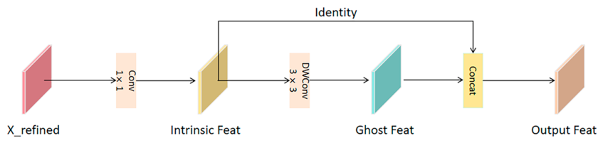
Furthermore, to alleviate the computational burden imposed by high-resolution UAV images and better accommodate the limited computing capacity of airborne edge devices, LG-CAM incorporates a Ghost Module strategy, as illustrated in Figure 5.
First, a limited number of standard convolutional kernels are utilized to extract the core semantic features, denoted as Y = f p r i m a r y ( X r e f i n e d ) . Subsequently, a series of low-cost linear operations Φ j are applied to Y to generate the ghost features y g h o s t , j . Finally, these feature maps are concatenated to yield the combined output Y = C o n c a t ( [ Y , Y g h o s t ] ) . This design not only maintains computational efficiency but also improves the generalization capability of feature extraction in complex forest scenarios with varied illumination, occlusions, and diverse tree morphologies.

2.4.2. Boundary Difference Fusion Module

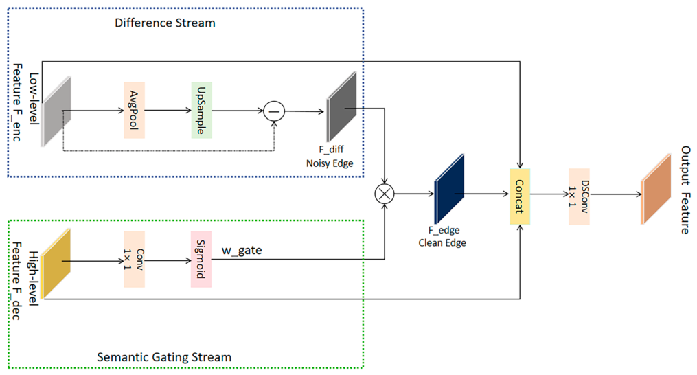
In dense natural forest stands, the branches and leaves of adjacent trees physically intertwine, often exhibiting contiguous growth patterns. Traditional U-Net architectures tend to lose subtle features of tree boundaries and canopy gaps during successive downsampling operations. Furthermore, when transferring low-level features to the decoder, conventional skip connections often introduce significant background noise, such as understory grass textures and projected shadows. Consequently, the final predicted masks fail to effectively sharpen the boundaries of overlapping tree crowns, which hinders individual tree separation in dense regions. To address this issue, we design a Boundary Difference Fusion Module specifically tailored for complex intertwined environments, as illustrated in Figure 6.
The BDF-Block is deployed along each skip connection of the network. It leverages spatial low-pass and high-pass decomposition to isolate high-frequency edge information. First, average pooling with a kernel size of k = 3 followed by upsampling is applied to the shallow input features F e n c , generating blurred low-frequency features. A difference operation is then performed between the original and the blurred features. This strips away large smooth background regions (e.g., continuous canopy sun flecks) and extracts the differential high-frequency features F d i f f containing physical branch contours. The formulation is as follows:
F d i f f = F e n c U u p ( P a v g ( F e n c ) )
Although F d i f f retains rich canopy edge information, it inadvertently includes high-frequency textures from rough understory vegetation. To mitigate this, the module introduces a semantic gating mechanism guided by the high-level semantic features F d e c . A gating weight W g a t e = σ ( C o n v 1 × 1 ( F d e c ) ) is generated via a 1 × 1 convolution and a Sigmoid activation function. This deep semantic weight matrix is used to weight and filter the shallow differential features. It suppresses high-frequency responses in non-canopy regions, yielding the purified boundary features F e d g e :
F e d g e = F d i f f W g a t e
This strategy of semantic guidance and differential correction serves a dual purpose: a low-level noise filter and a canopy edge sharpener. Finally, Depthwise Separable Convolutions (DSConv) are employed to efficiently concatenate and fuse F e n c , F e d g e , and F d e c along the channel dimension. This module fully exploits the inherent physical pixel gradients of high-resolution UAV imagery. It compels the network to restore canopy gaps that were blurred during downsampling within the deep semantic reconstruction process. Consequently, it effectively alleviates the issue of adjoining individual trees in dense stands.

2.5. Boundary-Aware Hybrid Loss Function

Canopy images often suffer from imbalanced background pixel proportions. Furthermore, even manually refined edges in dense forests struggle to achieve absolute pixel-perfect alignment. Consequently, relying solely on Cross-Entropy or Dice loss often leads to smooth or blurred predictions at complex boundaries. To achieve finer end-to-end supervision, we design a hybrid loss function comprising a region consistency loss ( L r e g i o n ) and a boundary-aware loss ( L b o u n d ).
To alleviate training bias caused by imbalanced background pixels, we combine Dice Loss and Focal Loss to construct the region loss L r e g i o n . The Dice Loss is utilized to optimize the overall set similarity, formulated as
L D i c e = 1 2 i = 1 N p i y i + ϵ i = 1 N p i + i = 1 N y i + ϵ
The Focal Loss is employed to modulate hard samples (e.g., easily confused shadows), expressed as
L F o c a l = 1 N i = 1 N α y i ( 1 p i ) γ log ( p i ) + ( 1 α ) ( 1 y i ) p i γ log ( 1 p i )
The region loss is defined as L r e g i o n = L D i c e + L F o c a l .
To prevent the network from generating jagged edges in intertwined environments and to maximize the edge extraction capability of the BDF-Block, a gradient-based boundary-aware loss is introduced. A differentiable Sobel operator is utilized to extract the gradient magnitude maps P and Y from the prediction map P and the ground truth Y , respectively. The boundary constraint is formulated as the Dice distance on the gradient maps, calculated as
L b o u n d = 1 2 i = 1 N ( p i · y i ) + ϵ i = 1 N ( p i ) 2 + i = 1 N ( y i ) 2 + ϵ
By optimizing L b o u n d , the network is forced to generate more distinct gradient responses at canopy boundaries, thereby improving the quality of instance separation in densely planted regions.
The total optimization objective is defined as L t o t a l = L r e g i o n + λ L b o u n d , where λ is a balancing coefficient. To prevent numerical overflow caused by a zero denominator during computation, a small constant ϵ is introduced as a smoothing term in the aforementioned equations. In this study, ϵ is uniformly set to 1 × 1 0 5 . Through the synergistic effect of the aforementioned structural improvements and the hybrid loss, LGBU-Net successfully extracts more essential canopy features from manually refined, high-quality labels. This achieves a highly accurate and efficient individual tree segmentation solution for forestry remote sensing, which is well-suited for edge deployment.

2.6. Model Evaluation Metrics

To comprehensively and objectively quantify the actual performance of the proposed improved model in fine tree crown segmentation tasks, this paper constructs a multi-dimensional quantitative evaluation system. This system covers computational overhead, pixel-level segmentation accuracy, and instance-level boundary quality. First, to evaluate operational efficiency and lightweight deployment potential, parameters and floating-point operations (FLOPs) are introduced as physical metrics. These two metrics intuitively reflect the spatial storage cost and temporal inference complexity of the algorithm, respectively, serving as crucial criteria for assessing the feasibility of deploying the model in practical forestry remote sensing applications.
Regarding pixel-level accuracy evaluation, all metrics are derived from the confusion matrix. The specific statistical components are defined as follows: True Positive (TP) represents the number of pixels correctly predicted as tree crowns; False Negative (FN) denotes undetected actual tree crown pixels; False Positive (FP) refers to background pixels erroneously classified as tree crowns; and True Negative (TN) stands for accurately identified background regions. Based on these components, three core metrics are selected: Intersection over Union (IoU), Overall Accuracy (Acc), and F1-score. As the primary benchmark in remote sensing semantic segmentation, IoU strictly quantifies the spatial overlap between the predicted masks and the ground truth annotations. Acc indicates the probability of all pixels in the global image being correctly classified, reflecting the model’s overall prediction capability. The F1-score, serving as the harmonic mean of precision and recall, effectively overcomes evaluation biases caused by complex forest backgrounds and severe foreground/background pixel imbalances, demonstrating the model’s robustness against class imbalance. The corresponding formulas are as follows:
I o U = T P T P + F P + F N
A c c = T P + T N T P + T N + F P + F N
F 1 = 2 × T P 2 × T P + F P + F N
However, since canopy distributions in natural forests are often dense and frequently accompanied by severe interlocking and overlapping, relying solely on global pixel-level metrics struggles to accurately reflect the model’s capability to differentiate individual trees and delineate fine edges. Therefore, this paper further explicitly introduces the object-level F1-score ( F 1 o b j , %) and the 95th percentile Hausdorff Distance (HD95, pixels). Calculated based on connected component analysis, F 1 o b j directly reflects the model’s ability at the object level to overcome adjacent canopy adhesion and achieve effective individual tree separation. HD95 is specifically utilized to measure the maximum local spatial deviation between the predicted canopy boundaries and the physical ground truth boundaries. Compared to IoU, which is more sensitive to internal pixels, HD95 focuses more on the morphological fitting degree of the contours. A smaller HD95 value indicates a tighter alignment between the predicted and actual boundaries, with less jagged noise and boundary blurring. Relying on this hierarchical evaluation system, this paper systematically assesses the comprehensive performance of the network across four dimensions: underlying computational efficiency, global spatial response, instance-level separation capability, and local edge fidelity.
F 1 o b j = 2 × P r e c i s i o n o b j × R e c a l l o b j P r e c i s i o n o b j + R e c a l l o b j
H D 95 ( X , Y ) = max ( P 95 % ( { min y Y | | x y | | | x X } ) , P 95 % ( { min x X | | x y | | | y Y } ) )

3. Results

3.1. Experimental Setup

To ensure the objectivity and rigor of the experimental comparisons, all baseline models evaluated in this study are uniformly integrated and reproduced within the MMSegmentation open-source vision framework. During the training process, the global random seed is fixed to eliminate the interference of random errors caused by network initialization. Furthermore, no additional or complex customized hyperparameter tuning is applied to the comparative models. Meanwhile, consistent computational environments and data partitioning strategies are adopted for the training and validation of different algorithms, thereby establishing a reliable evaluation benchmark. The specific training configurations and core hyperparameter settings for this study are detailed in Table 2 and Table 3.

3.2. Comparative Experiment and Results Analysis

To objectively evaluate the segmentation performance and robustness of LGBU-Net on the manually refined dataset, this study constructs multi-dimensional baseline comparative experiments. First, the universal zero-shot vision baseline, Grounding DINO + SAM, is introduced to assess the direct inference capability of foundation models without specific training on forestry scenarios. Secondly, four representative mainstream segmentation networks are selected as comparative baselines trained on the identical supervised data. These networks encompass the classic fully convolutional architecture FCN-8s, the foundational encoder–decoder network U-Net, DeepLabV3+ featuring the Atrous Spatial Pyramid Pooling (ASPP) module, and the vision Transformer-based SegFormer. Furthermore, to quantify the accuracy gap between the lightweight improved architecture and traditional complex fully supervised methods, this study additionally introduces a well-performing conventional fully supervised model to serve as a performance reference for this task, as illustrated in Figure 7.
The comprehensive quantitative evaluation results of each model are detailed in Table 4.
Through a comprehensive comparison and in-depth analysis of the quantitative results in Table 4, the proposed LGBU-Net achieves optimal performance across multiple metrics. This robustly validates the significant superiority of this paradigm compared to traditional semantic segmentation methods.
First, the cascaded model of Grounding DINO and SAM, serving as the baseline for auxiliary preliminary annotation and comparison, possesses over 350 M parameters and an extensive computational overhead exceeding 1500 G FLOPs. However, lacking prior inductive biases specific to the vertical forestry domain, it tends to mistakenly identify adjacent tree crowns as a single entity when processing high-canopy-density forest areas. This limitation, arising from the absence of targeted training on specific forest stand characteristics, results in an object-level F 1 o b j of merely 64.20% for individual trees, while the HD95 metric, which reflects boundary errors, reaches as high as 19.5 pixels.
Under the condition of utilizing the identical batch of manually refined, high-quality training data as supervision signals, traditional global fully convolutional networks (e.g., FCN-8s and DeepLabV3+) lack an edge sharpening mechanism tailored for densely intertwined canopies. Consequently, they are prone to connected component misjudgments and boundary blurring in complex forest regions. Notably, even when employing a conventional MobileNetV3-based U-Net for pure semantic segmentation, despite achieving a pixel-level IoU of 88.59%, its performance remains restricted. The lack of attentional focus on target regions within the global image makes it susceptible to interference from homogenous understory backgrounds, thereby limiting both individual tree separation accuracy ( F 1 o b j 85.20%) and boundary alignment (HD95 12.6 pixels).
Compared to the zero-shot direct inference results of general vision foundation models, LGBU-Net benefits from the high-quality training labels generated with the assistance of Grounding DINO and SAM and subsequently refined manually. This allows the network to more comprehensively learn canopy structural priors and boundary features under complex forest conditions, yielding superior performance in pixel-level accuracy, individual tree separation capability, and boundary-fitting quality. Specifically, its canopy IoU increases to a peak value of 90.45%, the object-level F 1 o b j improves to 89.35%, and the HD95 error is compressed to 6.8 pixels. Concurrently, our model achieves a statistical significance level of p < 0.05 with both IoU and F1-score. This series of significant accuracy enhancements demonstrates that the proposed paradigm effectively overcomes the challenge of target adhesion in complex forest stands. Guided by manually refined, high-quality supervisory signals, the network can better learn and reconstruct the authentic and distinct physical morphological features of tree crowns.
While achieving substantial accuracy improvements, LGBU-Net strikes a favorable balance between computational overhead and inference efficiency. Benefiting from the Ghost feature generation strategy introduced during the feature extraction stage and the depthwise separable convolution design in the feature fusion pathways, the overall parameter count of LGBU-Net is compressed to merely 4.85 M, with the computational cost reduced to 5.42 G FLOPs—lower than the 6.71G FLOPs of the conventional MobileNetV3-based U-Net. It is important to note that the parameters and FLOPs reported in Table 4 exclusively account for the ultimately deployed LGBU-Net segmentation network. They do not include Grounding DINO and SAM, which are utilized during the offline label construction phase. Since the foundation models are employed solely for training data generation and are not involved in the forward inference during model deployment, our discussions regarding lightweight design and edge deployment capabilities are strictly focused on LGBU-Net itself.
To further investigate and validate the specific physical contributions of the internal innovative designs of LGBU-Net in handling complex backgrounds and resolving the issue of dense individual tree adhesion, this study conducts progressive ablation experiments while maintaining the identical test set. The experiments utilize the MobileNetV3-based U-Net, trained with a pure Dice loss function, as the evolutionary baseline. By incrementally integrating the Lightweight Ghost-Coordinate Attention Module (LG-CAM), the Boundary Difference Fusion Module (BDF-Block), and the hybrid loss function, the study aims to systematically reveal how these core components operate synergistically to achieve background suppression and individual tree boundary rectification in complex habitats.

3.3. Ablation Experiments and Noise Reduction Mechanisms

To thoroughly investigate the specific contributions of the core components in LGBU-Net (i.e., LG-CAM, BDF-Block, and the hybrid loss function) towards mitigating label noise and resolving individual tree adhesion, we conducted progressive ablation experiments on the identical test set. A MobileNetV3-based U-Net trained exclusively with the Dice loss function was utilized as the baseline model. The quantitative results of the ablation study are shown in Table 5.
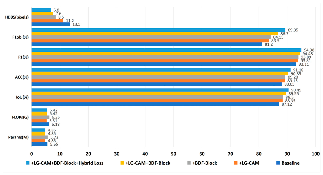
The data in Table 5 indicate that the three key mechanisms designed in this study yield favorable practical results in mitigating complex background interference and resolving individual tree adhesion. Based on the baseline model (Model A), which utilizes MobileNetV3-UNet trained with Dice Loss, the independent introduction of the Lightweight Ghost-Coordinate Attention Module (LG-CAM, Model B) brings notable improvements. Benefiting from the redundant feature elimination mechanism of the Ghost Module, the network’s parameter count decreases from 5.65 M to 4.85 M, with floating-point operations simultaneously reduced to 5.31 G. While the computational overhead is lowered, the canopy IoU steadily increases by 1.23 percentage points (reaching 88.35%). This data variation suggests that in training environments featuring complex ground backgrounds, the coordinate perception capability of LG-CAM helps the network better concentrate response features on the central regions of the canopy. This mechanism effectively suppresses interference from background noise, such as understory grass and shadows, thereby improving the stability of individual tree localization while simultaneously reducing computational costs.
Regarding the core challenge of canopy adhesion in dense forest stands, the Boundary Difference Fusion Module (BDF-Block) plays a crucial corrective role. When the baseline model solely integrates this module (Model C), the object-level F 1 o b j , a core metric reflecting the degree of adhesion, exhibits a significant improvement from 81.20% to 84.15%. More importantly, the HD95 metric, which measures boundary error, drops substantially from 13.5 pixels to 8.5 pixels. This performance shift elucidates the physical significance of the BDF-Block from a data perspective. Traditional direct skip connections in U-Net tend to introduce blurred connected components from deep semantic features. Conversely, the BDF-Block explicitly extracts high-frequency physical gradients from the low-level features of the original UAV imagery. This differential gradient, derived from the original image information, acts as a spatial sharpener. It effectively separates adjacent canopies in dense regions and guides the network to optimize segmentation boundaries using authentic physical leaf edges. When the network combines both LG-CAM and BDF-Block (Model D), the model further elevates the object-level F 1 o b j to 86.70% and decreases HD95 to 7.6 pixels, all while maintaining a low parameter count of 4.85 M.
Building upon the integration of the aforementioned structural improvements in feature extraction and fusion, replacing the traditional single classification loss with a hybrid loss function that includes boundary-aware constraints (Model E) further enhances model performance. It is worth emphasizing that, as a strategy applying constraints solely during the training phase, the introduction of the hybrid loss achieves a substantial leap in accuracy without increasing inference parameters or computational burden. The hybrid loss boosts the canopy IoU to 90.45% and achieves an object-level F 1 o b j of 89.35%, and further compresses the HD95 error to 6.8 pixels. This result demonstrates that during gradient backpropagation, the boundary-aware constraint forces the network to reduce its reliance on blurred edge transition zones in the final stages of training, thereby generating sharper geometric edge responses. This loss function and the BDF-Block constitute a synergistic mechanism spanning from feature representation to target optimization. It effectively compensates for the lack of topological constraints in individual tree separation within high-canopy-density complex forests. Synthesizing the ablation results above, it is confirmed that the high-accuracy performance of LGBU-Net stems from the targeted optimization of complex backgrounds and edge details by both the internal network architecture and external supervision strategies. This ultimately establishes a reliable geometric foundation of individual trees for accurate canopy cover estimation. Figure 8 shows a bar chart comparison of ablation experimental data.

3.4. Qualitative Comparative Result Analysis

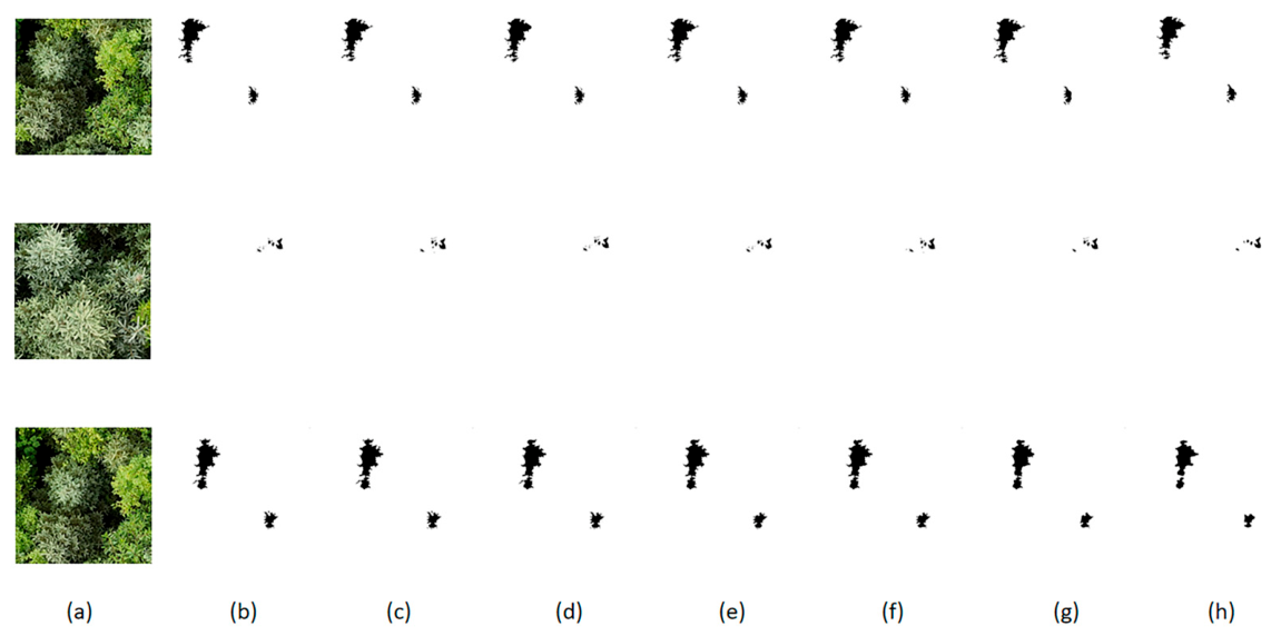
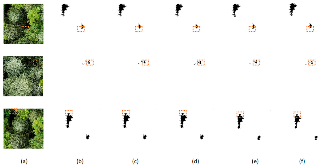
To evaluate the performance of the proposed canopy segmentation model, this section selects images of mixed and pure coniferous forest plots for qualitative comparison and visual analysis. Specifically, we compare the prediction results of the zero-shot vision baseline (Grounding DINO + SAM), several supervised segmentation baselines, and the proposed LGBU-Net. As illustrated in Figure 9, the various models exhibit distinct characteristics in delineating individual tree morphology, preserving edge details, and resisting interference from complex backgrounds.
Observing the extraction results of the Grounding DINO + SAM baseline reveals its fundamental target localization capability, as it successfully identifies the approximate spatial positions of most isolated tree crowns. However, in forest stands with high canopy density, the inference performance of this method is susceptible to the color similarity of canopies and mutual physical occlusions. In regions where multiple tree crowns intersect, the predicted masks generated by Grounding DINO and SAM frequently exhibit morphological smoothing and the merging of adjacent crowns, struggling to achieve fine delineation of individual tree boundaries. Such segmentation results, driven by global feature similarity, suffer from evident under-segmentation errors and topological adhesion. If directly applied to forest stand parameter extraction, these inaccuracies often obscure authentic canopy gaps.
In contrast, the LGBU-Net model demonstrates superior capabilities in detailed feature extraction and individual tree separation. As observed in the visualization results, LGBU-Net clearly delineates individual tree contours and restores boundary details frequently overlooked by other methods. This visual performance is primarily attributed to the internal Boundary Difference Fusion Module. By extracting high-frequency physical gradients from UAV imagery, this module guides the network to locate leaf intersection gaps within dense regions. In mixed forest areas characterized by overlapping canopies, the individual tree boundaries output by LGBU-Net exhibit rich morphological variations that reflect the physical traits of irregular crown extension. This demonstrates the network’s robust capacity to extract effective semantic features within the spatial domain.
Further examination of local details under complex environmental interference reflects the model’s adaptability to challenging optical conditions. In the boxed regions of Figure 9, forest gap shadows, understory bare soil, and weeds easily induce semantic confusion for segmentation algorithms. Within such areas, the baseline models are prone to over-segmentation, frequently fragmenting continuous canopies due to localized shadows. Conversely, leveraging the feature-focusing effect of the Lightweight Ghost-Coordinate Attention mechanism, LGBU-Net maintains a receptive field that stably anchors on the geometric centers of individual trees. Visually, the network effectively mitigates understory background interference and preserves the relative structural integrity of individual trees in plots with uneven illumination. Furthermore, constrained by the boundary-aware hybrid loss, the model exhibits high sensitivity to the radial branch edges characteristic of coniferous forests, facilitating a clear separation of intertwined coniferous canopies.
This restoration of pixel-level boundaries positively impacts subsequent canopy cover estimation. Because LGBU-Net effectively suppresses the adhesion of adjacent canopies, subtle canopy gaps are successfully preserved. The accurate identification of these gaps is a prerequisite for improving the precision of canopy cover estimations. Qualitative results demonstrate that the proposed segmentation framework reconstructs a highly reliable spatial topology of individual trees. It generates highly discriminative binary maps of canopy cover, thereby providing a robust morphological foundation for deriving objective forest canopy cover indices in subsequent analyses.

3.5. Verification and Error Analysis of Canopy Cover Estimation Accuracy

As shown in Table 6, the analysis of the stratification inversion results of 168 plots independent of the training area shows that the proposed canopy segmentation model achieves high quantitative estimation accuracy within a canopy coverage range of 40% to 100%. Specifically, it yields an overall root-mean-square error (RMSE) of 3.65% and an overall bias of −0.45%. Furthermore, comparisons using selected representative plots reveal a coefficient of determination ( R 2 ) greater than 0.90, indicating a significant positive correlation. These results indicate that the proposed model can achieve reliable canopy cover inversion relying solely on consumer-grade UAV RGB sensors. Consequently, it provides a viable technical solution for rapid, low-cost, and large-scale forestry monitoring.
The error patterns across different canopy cover levels reflect the physical limitations of optical remote sensing in complex forest scenarios, while also demonstrating the practical efficacy of the feature extraction and optimization mechanisms proposed in this study. In traditional image segmentation algorithms, positive biases in low-canopy-cover plots are typically caused by background noise from forest clearings. Illumination variations often lead to the misclassification of dark shadows, low shrubs, or tall herbs as tree crowns, thereby resulting in an overestimation of canopy cover. However, benefiting from the supervisory role of high-quality, manually refined training labels and the feature anchoring effect of LG-CAM on central target regions, LGBU-Net effectively filters out homogeneous understory noise. Consequently, it successfully restrains the positive bias in low-density areas to a minimal level.
Conversely, the negative bias observed in high-canopy-cover areas is primarily attributed to canopy overlap and the absence of clear physical boundaries within dense forest stands. Traditional algorithms are prone to under-segmentation in such regions, erroneously merging adjacent trees and resulting in a total extracted projected canopy area that is smaller than the actual value. To address this issue, the Boundary Difference Fusion Module (BDF-Block) and the hybrid loss function, both introduced during the decoding stage in this study, play a crucial role. By explicitly extracting high-frequency physical gradients from the original UAV imagery, the network assists in restoring the physical gaps and edges of authentic canopies in the spatial domain, thereby ameliorating the topological adhesion of dense tree crowns. Therefore, although a slight underestimation (−1.85%) persists in high-density stands due to the physical intertwining of branches and leaves, LGBU-Net demonstrates superior boundary fidelity and error control capabilities compared to the substantial negative biases typical of traditional methods. This indicates that the proposed segmentation model, while maintaining a strong balance between computational efficiency (5.42 G FLOPs) and extraction accuracy, provides a feasible, lightweight solution for the edge-computing-based inversion of large-scale forest ecological parameters.

4. Discussion

The performance of LGBU-Net in fine-grained forest canopy segmentation demonstrates a significant methodological advancement over conventional segmentation frameworks, which often struggle with the morphological distortion and over-smoothing characteristic of complex forest imagery [42]. By integrating a boundary-aware hybrid loss function and the BDF-Block, our approach moves beyond the limitations of purely global semantic-driven methods, such as standard U-Net or DeepLabV3+ architectures, by explicitly leveraging high-frequency gradient information. This is quantitatively supported by the marked reduction in the 95th percentile Hausdorff Distance (HD95) to 6.8 pixels, a substantial improvement compared to classical frameworks like FCN-8s (22.4 pixels) and DeepLabV3+ with ResNet-50 (16.5 pixels). This decrease in HD95 indicates that our boundary-preserving mechanisms preserve sharper, geometrically more accurate crown edges rather than over-smoothed approximations. This shift from relying on global color/texture similarities to prioritizing topological boundary constraints allows for a more precise delineation of individual trees in dense stands.
While recent studies have highlighted the efficiency of various deep learning architectures in remote sensing, LGBU-Net addresses a critical gap by maintaining high segmentation accuracy with a substantially lower parameter count (4.85 M) and computational complexity (5.42 G FLOPs). Compared to massive zero-shot foundation models such as Grounding DINO + SAM, which require excessive resources (>350 M parameters and >1500 G FLOPs) but underperform on this domain-specific task with an IoU of 76.85%, LGBU-Net demonstrates a much more efficient trade-off with an IoU of 90.45%. Furthermore, when benchmarked against popular lightweight networks, our model outperforms BiSeNetV2 (3.45 M parameters, 77.58% IoU) and DeepLabV3+ with a MobileNetV2 backbone (5.86 M parameters, 83.45% IoU) across all metrics while keeping the computational footprint within a comparable or even lower range. This provides a more viable pathway for real-time edge-computing applications in forestry inventories compared to existing heavy transformer-based models.
Despite these advancements, the framework is subject to physical and geographical constraints that must be acknowledged. The observed residual bias in high-canopy-cover areas (Bias = −1.85%) underscores the inherent limitation of relying solely on 2D RGB optical imagery, which lacks the vertical spatial data necessary to fully resolve three-dimensional canopy structures or distinguish understory saplings from dominant canopy layers [43]. This limitation suggests that 2D segmentation remains constrained by the “top-down” nature of visible-light sensors, a finding consistent with broader challenges reported in canopy extraction literature regarding the occlusion of sub-canopy layers. Furthermore, while the model exhibits robustness within the tested mixed and coniferous plots, its direct transferability to more structurally diverse biomes—such as tropical broadleaf forests with massive, interlocked canopies, temperate deciduous forests with high seasonal phenological variance, or sparse savannas—remains to be verified. The distinct canopy architectures and spectral properties of these ecosystems may challenge the model’s pre-trained feature extraction capabilities, indicating that further validation across heterogeneous landscapes is essential. Future work will focus on addressing these gaps by integrating auxiliary elevation priors, such as Digital Surface Models (DSM) or Canopy Height Models (CHM), to filter ground vegetation noise and facilitate vertical layer decoupling. Additionally, we aim to enhance the model’s universality by incorporating multi-biome training datasets and exploring adaptive feature alignment strategies, ensuring that the system can autonomously adjust its sensitivity to varying structural patterns across diverse global forest ecosystems.

5. Conclusions

To address the issues of boundary adhesion and high computational load faced by traditional high-precision tree canopy segmentation in dense forests, this study proposes and validates a canopy segmentation method based on a lightweight network (LGBU-Net). During the feature extraction and decoding stages, LGBU-Net introduces the lightweight Ghost-Coordinate Attention Mechanism (LG-CAM) and the Boundary Difference Fusion Block (BDF-Block), supplemented by a boundary-aware hybrid loss function. By combining localized feature attention with high-frequency gradient recovery, this design successfully improves the network’s segmentation performance in complex forest regions. The model effectively overcomes canopy overlap and adhesion issues within complex mixed and pure coniferous forests, achieving an individual tree F 1 o b j of 89.35%. Furthermore, it attains pixel-level accuracy superior to various conventional segmentation networks while maintaining a low computational cost (5.42 G FLOPs). In the application of macroscopic forest parameter retrieval, the canopy masks extracted by the model enable accurate plot-level canopy cover estimation (RMSE = 3.65%). In conclusion, this study provides an effective theoretical framework for resolving the challenge of separating high-canopy-cover tree crowns in forestry remote sensing. Additionally, it demonstrates strong potential for deployment on edge devices with limited computing power. This work lays a solid technical foundation for the future dynamic inventory of large-scale forest resources and UAV-based ecological monitoring.

Author Contributions

Conceptualization, H.C. and Z.L.; methodology, Z.L.; validation, M.L. and Z.X.; formal analysis, S.Z.; investigation, L.L. and Z.L.; resources, M.L.; data curation, Y.Z.; writing—original draft preparation, Z.L.; writing—review and editing, H.C.; supervision, C.W.; project administration, Y.Z.; funding acquisition, H.C. All authors have read and agreed to the published version of the manuscript.

Funding

This research was funded by the Science and Technology Basic Resources Investigation Program of China (2022FY101901-2) and the Industrial Technology and Development Project of the Development and Reform Commission of Jilin Province (2023C030-3).

Data Availability Statement

The original contributions presented in this study are included in the article. Further inquiries can be directed to the corresponding author.

Acknowledgments

The author thanks the relevant forestry departments for providing the data.

Conflicts of Interest

The authors declare no conflicts of interest.

References

  1. Zhang, B.; Wang, Z.; Ma, T.; Wang, Z.; Li, H.; Ji, W.; He, M.; Jiao, A.; Feng, Z. Correcting forest aboveground biomass biases by incorporating independent canopy height retrieval with conventional machine learning models using GEDI and ICESat-2 data. Ecol. Inform. 2025, 86, 103045. [Google Scholar] [CrossRef]
  2. Beloiu, M.; Heinzmann, L.; Rehush, N.; Gessler, A.; Griess, V.C. Individual tree-crown detection and species identification in heterogeneous forests using aerial RGB imagery and deep learning. Remote Sens. 2023, 15, 1463. [Google Scholar] [CrossRef]
  3. Xiao, Y.; Wang, Q.; Xi, H.; Tong, X. A 30 m canopy height map in China created by fusion of multiple relative height metrics. IEEE Trans. Geosci. Remote Sens. 2025, 63, 4411116. [Google Scholar] [CrossRef]
  4. Wang, Q.; Bi, W.; Xu, W.; Huang, W.; Yin, X. A voxel-based canopy closure estimation method considering LiDAR scanning density. Eng. Res. Express 2025, 7, 025275. [Google Scholar] [CrossRef]
  5. Luo, H.; Ou, G.; Yue, C.; Zhu, B.; Wu, Y.; Zhang, X.; Lu, C.; Tang, J. A framework for montane forest canopy height estimation via integrating deep learning and multi-source remote sensing data. Int. J. Appl. Earth Obs. Geoinf. 2025, 138, 104474. [Google Scholar] [CrossRef]
  6. Abolt, C.J.; Santos, J.E.; Atchley, A.L.; Wells, L.; Martin, D.; Parsons, R.A.; Linn, R.R. Deep-learning-based canopy height model generation from sub-meter resolution panchromatic satellite imagery. Mach. Learn. Sci. Technol. 2025, 6, 015013. [Google Scholar] [CrossRef]
  7. Asadpour, V.; Xie, F. Artificial intelligence for medical imaging: A review of U-Net technology for anatomical feature analysis. Intell. Med. 2025, 6, 24–39. [Google Scholar] [CrossRef]
  8. Chen, H.; Li, Z.; Li, M.; Song, Y.; Zhai, H.; Liu, J.; Wu, H.; Wen, C.; Zhang, Y. Research on Forest Canopy Cover Estimation Method Based on MSG-UNet Using UAV Remote Sensing Data. Remote Sens. 2026, 18, 809. [Google Scholar] [CrossRef]
  9. Yao, Z.; Chai, G.; Lei, L.; Jia, X.; Zhang, X. Individual tree species identification and crown parameters extraction based on mask R-CNN: Assessing the applicability of unmanned aerial vehicle optical images. Remote Sens. 2023, 15, 5164. [Google Scholar] [CrossRef]
  10. Syazwani, R.W.N.; Asraf, H.M.; Amin, M.M.S.; Dalila, K.N. Automated image identification, detection and fruit counting of top-view pineapple crown using machine learning. Alex. Eng. J. 2022, 61, 1265–1276. [Google Scholar] [CrossRef]
  11. Ball, J.G.; Hickman, S.H.; Jackson, T.D.; Koay, X.J.; Hirst, J.; Jay, W.; Archer, M.; Aubry-Kientz, M.; Vincent, G.; Coomes, D.A. Accurate delineation of individual tree crowns in tropical forests from aerial RGB imagery using Mask R-CNN. Remote Sens. Ecol. Conserv. 2023, 9, 641–655. [Google Scholar] [CrossRef]
  12. Huo, L.; Lindberg, E.; Holmgren, J. Towards low vegetation identification: A new method for tree crown segmentation from LiDAR data based on a symmetrical structure detection algorithm (SSD). Remote Sens. Environ. 2022, 270, 112857. [Google Scholar] [CrossRef]
  13. Santini, F.; Kefauver, S.C.; Araus, J.L.; Resco de Dios, V.; Martin Garcia, S.; Grivet, D.; Voltas, J. Bridging the genotype—Phenotype gap for a Mediterranean pine by semi-automatic crown identification and multispectral imagery. New Phytol. 2021, 229, 245–258. [Google Scholar] [CrossRef]
  14. Ecke, S.; Stehr, F.; Frey, J.; Tiede, D.; Dempewolf, J.; Klemmt, H.J.; Endres, E.; Seifert, T. Towards operational UAV-based forest health monitoring: Species identification and crown condition assessment by means of deep learning. Comput. Electron. Agric. 2024, 219, 108785. [Google Scholar] [CrossRef]
  15. Chen, B.; Zhang, N.; Li, Y.; Li, Z.; Chai, X. Cross-modal data integration and spectral optimization for enhanced individual apple tree canopy nitrogen concentration estimation using UAV remote sensing. Plant Phenomics 2026, 8, 100172. [Google Scholar] [CrossRef] [PubMed]
  16. Liu, S.; Zeng, Z.; Ren, T.; Li, F.; Zhang, H.; Yang, J.; Jiang, Q.; Li, C.; Yang, J.; Su, H.; et al. Grounding dino: Marrying dino with grounded pre-training for open-set object detection. In Proceedings of the European Conference on Computer Vision; Springer: Berlin/Heidelberg, Germany, 2024; pp. 38–55. [Google Scholar]
  17. Kirillov, A.; Mintun, E.; Ravi, N.; Mao, H.; Rolland, C.; Gustafson, L.; Xiao, T.; Whitehead, S.; Berg, A.C.; Lo, W.Y.; et al. Segment anything. In Proceedings of the IEEE/CVF International Conference on Computer Vision; IEEE: New York, NY, USA, 2023; pp. 4015–4026. [Google Scholar]
  18. Hao, Z.; Lin, L.; Post, C.J.; Mikhailova, E.A.; Li, M.; Chen, Y.; Yu, K.; Liu, J. Automated tree-crown and height detection in a young forest plantation using mask region-based convolutional neural network (Mask R-CNN). ISPRS J. Photogramm. Remote Sens. 2021, 178, 112–123. [Google Scholar] [CrossRef]
  19. Bahadir, M.; Karsli, F.; Yildirim, F.S.; Misir, M. Tree crown segmentation and estimation of metrics from point clouds with improved local maximum method. Photogramm. Rec. 2025, 40, e70015. [Google Scholar] [CrossRef]
  20. Ren, X.; Cheng, B.; Wang, S.; Dong, M.; Chai, P.; Yang, Z. Research on fine segmentation method of hyperspectral remote sensing canopy images based on quantum-enhanced U-Net. J. Electron. Imaging 2026, 35, 023010. [Google Scholar] [CrossRef]
  21. Zhong, Y.; Liu, S.; Sun, H. A 3D point cloud instance segmentation network for extracting individual trees from complex forest scenes. Comput. Electron. Agric. 2026, 242, 111333. [Google Scholar] [CrossRef]
  22. Howard, A.; Sandler, M.; Chu, G.; Chen, L.C.; Chen, B.; Tan, M.; Wang, W.; Zhu, Y.; Pang, R.; Vasudevan, V.; et al. Searching for mobilenetv3. In Proceedings of the IEEE/CVF International Conference on Computer Vision, Seoul, Republic of Korea, 27 October–2 November 2019; pp. 1314–1324. [Google Scholar]
  23. Hosingholizade, A.; Erfanifard, Y.; Alavipanah, S.K.; Millan, V.E.G.; Mielcarek, M.; Pirasteh, S.; Stereńczak, K. Assessment of Pine Tree Crown Delineation Algorithms on UAV Data: From K-Means Clustering to CNN Segmentation. Forests 2025, 16, 228. [Google Scholar] [CrossRef]
  24. Pucino, N.; McVicar, T.R.; Levick, S.R.; van Dijk, A.I. Assessing optimization strategies for unsupervised individual tree crown detection and delineation to support continental-scale inventories: Role of vegetation type and point cloud data density. Sci. Remote Sens. 2026, 13, 100396. [Google Scholar] [CrossRef]
  25. Lu, T.; Huang, F.; Ding, Y.; Lv, Q.; Guan, H.; Li, G.; Kang, X.; Teng, G. A Novel Urban Biological Parameter Estimation Method Based on LiDAR Point Cloud Single-Tree Segmentation. Remote Sens. 2026, 18, 1001. [Google Scholar] [CrossRef]
  26. Ács, N.; Heil, B.; Szász, B.; Folcz, Á.; Preisinger, M.; Sándor, G.; Czimber, K. Two-Phase Forest Damage Assessment with Sentinel-2 NDVI Double Differencing and UAV-Based Segmentation in the Sopron Mountains. Remote Sens. 2026, 18, 803. [Google Scholar] [CrossRef]
  27. Lei, L.; Chai, G.; Yao, Z.; Li, Y.; Jia, X.; Zhang, X. A novel self-similarity cluster grouping approach for individual tree crown segmentation using multi-features from UAV-based LiDAR and multi-angle photogrammetry data. Remote Sens. Environ. 2025, 318, 114588. [Google Scholar] [CrossRef]
  28. Ma, G.; Yang, G.; Lu, H.; Zhang, X. Forest Three-Dimensional Reconstruction Method Based on High-Resolution Remote Sensing Image Using Tree Crown Segmentation and Individual Tree Parameter Extraction Model. Remote Sens. 2025, 17, 2179. [Google Scholar] [CrossRef]
  29. Tong, F.; Zhang, Y. Individual tree crown delineation in high resolution aerial RGB imagery using StarDist-based model. Remote Sens. Environ. 2025, 319, 114618. [Google Scholar] [CrossRef]
  30. Lungo Vaschetti, J.; Arnaudo, E.; Rossi, C. TreePseCo: Scaling Individual Tree Crown Segmentation using Large Vision Models. Int. Arch. Photogramm. Remote Sens. Spat. Inf. Sci. 2025, 48, 275–282. [Google Scholar] [CrossRef]
  31. Ma, J.; Yan, L.; Chen, B.; Zhang, L. A Tree Crown Segmentation Approach for Unmanned Aerial Vehicle Remote Sensing Images on Field Programmable Gate Array (FPGA) Neural Network Accelerator. Sensors 2025, 25, 2729. [Google Scholar] [CrossRef] [PubMed]
  32. Ding, J.; You, L.; Liang, Y.; Huang, J.; Wu, Z.; Huang, R.; Chen, J.; You, H. Research on eucalyptus individual tree segmentation and age estimation utilizing improved Mask R-CNN algorithm based on UAV stereo images. Ind. Crops Prod. 2025, 230, 121073. [Google Scholar] [CrossRef]
  33. Sun, Z.; Xue, B.; Zhang, M.; Schindler, J. Feature Fusion to Improve YOLOv8 for Segmenting and Classifying Aerial Images of Tree Crowns. IEEE J. Sel. Top. Appl. Earth Obs. Remote Sens. 2025, 18, 14752–14765. [Google Scholar] [CrossRef]
  34. Park, G.; Song, B.; Park, K. Mapping individual tree crowns to extract morphological attributes in urban areas using unmanned aerial vehicle-based LiDAR and RGB data. Ecol. Inform. 2025, 88, 103165. [Google Scholar] [CrossRef]
  35. Rodrıguez-Malpica, A.E.L.; Zouaghi, H.; Moshkenani, M.M.; Peng, W. Tree crown prediction of spruce tree using a machine- learning-based hybrid image processing method. Urban For. Urban Green. 2025, 107, 128815. [Google Scholar] [CrossRef]
  36. Li, N.; Jiang, S.; Zhou, Y.; He, W.; Jia, S. Fuzzy Boundary-Aware Network for Hyperspectral Individual Tree Fine Recognition. IEEE Trans. Geosci. Remote Sens. 2025, 63, 5541016. [Google Scholar] [CrossRef]
  37. Shaheen, L.; Rasheed, B.; Mazzara, M. Self-Supervised Learning for Precise Individual Tree Segmentation in Airborne LiDAR Point Clouds. IEEE Access 2025, 13, 70895–70908. [Google Scholar] [CrossRef]
  38. Ma, H.; Zhang, F.; Chen, S.; Yu, J. Individual Tree Segmentation Using Deep Learning and Climbing Algorithm: A Method for Achieving High-precision Single-tree Segmentation in High-density Forests under Complex Environments. Photogramm. Eng. Remote Sens. 2025, 91, 101–110. [Google Scholar] [CrossRef]
  39. Barber, C.; Cruz, J.; Graves, S.J.; Bohlman, S.A.; Zuidema, P.A.; Asner, G.P.; Carignan, A.; Vasquez, V.; Brandt, J.; Caughlin, T.T. Large, isolated trees have higher mortality than smaller trees in forest fragments across a tropical pastoral landscape. Ecol. Appl. 2025, 35, e70046. [Google Scholar] [CrossRef]
  40. Kefalas, A.; Kalampokas, T.; Vrochidou, E.; Papakostas, G.A. A vision-based pruning algorithm for cherry tree structure elements segmentation and exact pruning points determination. Comput. Electron. Agric. 2025, 237, 110735. [Google Scholar] [CrossRef]
  41. Zhong, Y.; Qin, J.; Liu, S.; Ma, Z.; Liu, E.; Fan, H. An unsupervised semantic segmentation network for wood-leaf separation from 3D point clouds. Plant Phenomics 2025, 7, 100064. [Google Scholar] [CrossRef]
  42. Chen, L.; Chen, Y. Intelligent Tree Canopy Segmentation From UAV Imagery to Support Urban and Rural Garden Design. IEEE J. Sel. Top. Appl. Earth Obs. Remote Sens. 2026, 19, 11541–11559. [Google Scholar] [CrossRef]
  43. Monroy-Anieva, J.A.; Téllez-Quiñones, A.; Lopez-Farías, R.; Aguilar-Sierra, H. Tree Canopy Segmentation and Characterization Using LiDAR for Machine Learning Models. In Proceedings of the 2026 IEEE/SICE International Symposium on System Integration (SII); IEEE: New York, NY, USA, 2026; pp. 1399–1406. [Google Scholar]
Figure 1. Data augmentation operations: (a) original image; (b) brightness adjustment to 90%; (c) horizontal flip; (d) clockwise rotation to 90°; (e) add noise; (f) contrast adjustment to 80%.
Remotesensing 18 01767 g001
Figure 2. Flowchart of the partitioning paradigm.
Remotesensing 18 01767 g002
Figure 3. Overall network architecture of the model.
Remotesensing 18 01767 g003
Figure 4. Lightweight Ghost-Coordinate Attention Module network structure diagram.
Remotesensing 18 01767 g004
Figure 5. Ghost Module network structure diagram.
Remotesensing 18 01767 g005
Figure 6. Boundary Difference Fusion Module network structure diagram.
Remotesensing 18 01767 g006
Figure 7. Comparison of experiments for each model in the comparative experiment: (a) UAV imagery model results; (b) Grounding DINO + SAM results; (c) FCN-8s model results; (d) U-Net model results; (e) DeepLabV3+ model results; (f) SegFormer model results; (g) U-Net model results; (h) results of this model.
Remotesensing 18 01767 g007
Figure 8. Bar graph comparison of data in ablation experiments.
Remotesensing 18 01767 g008
Figure 9. Comparison and analysis of segmentation results: (a) original UAV RGB image; (b) segmentation result of Model A; (c) segmentation result of Model B; (d) segmentation result of Model C; (e) segmentation result of Model D; (f) segmentation result of Model E.
Remotesensing 18 01767 g009
Table 1. Aerial photography equipment parameter data sheet.
ParameterSpecification
Equipment nameDJI Mini 4 Pro (DJI, Shenzhen, China)
Sensor1/1.3-inch CMOS sensor
Corresponding ground sampling distance1.3 cm
Effective pixels48 million
Relative flight altitude50 m
Equivalent focal length24 mm
Heading overlap≥80%
Lateral overlap≥70%
Spacing parallel routes22 m
Table 2. Experimental training configuration.
CategoryComponentSpecification
HardwareCPUIntel Xeon Gold 6330
GPUNVIDIA GeForce RTX 3090 (24 GB VRAM)
SoftwareOperating SystemUbuntu 20.04
Programming LanguagePython 3.8
Deep Learning FrameworkPyTorch 2.0.0
Computing PlatformCUDA 11.8
Table 3. Detailed hyperparameters of the experiment.
ParametersSetup
Epochs200
Batch Size16
Weight Decay5 × 10−4
Initial Learning Rate1 × 10−4
Train Images8064
Input Size512 × 512
OptimizerAdam
Table 4. Comprehensive performance comparison of different methods.
ModelBackboneParams (M)FLOPs (G)IoU (%)Acc (%)F1 (%)F1obj (%)HD95 (pixels)
Grounding DINO + SAMViT-H>350>150076.8580.2281.3464.2019.5
FCN-8sVGG16134.5162.8574.1278.5379.1560.1522.4
U-NetVGG1629.0565.4276.5581.1282.0565.8418.2
DeepLabV3+ResNet-5040.3545.2878.4783.0584.1169.4516.5
BiSeNetV2---3.455.8277.5882.1483.2568.4517.2
DeepLabV3+MobileNetV25.866.2583.4585.7289.5578.6514.8
SegFormerMiT-B113.7615.9179.6584.1585.2272.1515.1
U-NetMobileNetV35.656.7188.5988.6293.9585.2012.6
LGBU-Net (Ours)MobileNetV34.855.4290.4591.1894.9889.356.8
Table 5. Ablation experiment results.
ModelLG-CAMBDF-BlockHybrid Loss Params (M)FLOPs (G)IoU (%)ACC (%)F1 (%)F1obj (%)HD95 (pixels)
A 5.656.1887.1288.0593.1181.2013.5
B 4.855.3188.3589.1593.8183.5011.2
C 5.726.2588.5089.2893.8984.158.5
D 4.855.4289.5590.3594.4886.707.6
E (Ours)4.855.4290.4591.1894.9889.356.8
Table 6. Stratified validation statistics for canopy cover estimation across different density levels.
Density LevelRangeNo. of PlotsRMSE (%)Bias Error (%)
Low40–60%482.45+0.28
Medium60–80%703.36−0.12
High>80%504.95−1.85
Total 40–100%1683.65−0.45
Disclaimer/Publisher’s Note: The statements, opinions and data contained in all publications are solely those of the individual author(s) and contributor(s) and not of MDPI and/or the editor(s). MDPI and/or the editor(s) disclaim responsibility for any injury to people or property resulting from any ideas, methods, instructions or products referred to in the content.