
Integration of Optical and Microwave Satellite Data for Monitoring Vegetation Status in Sorghum Fields

 , , , , ,
  , ,
, ,  and
and
Abstract

1. Introduction
2. Materials and Methods
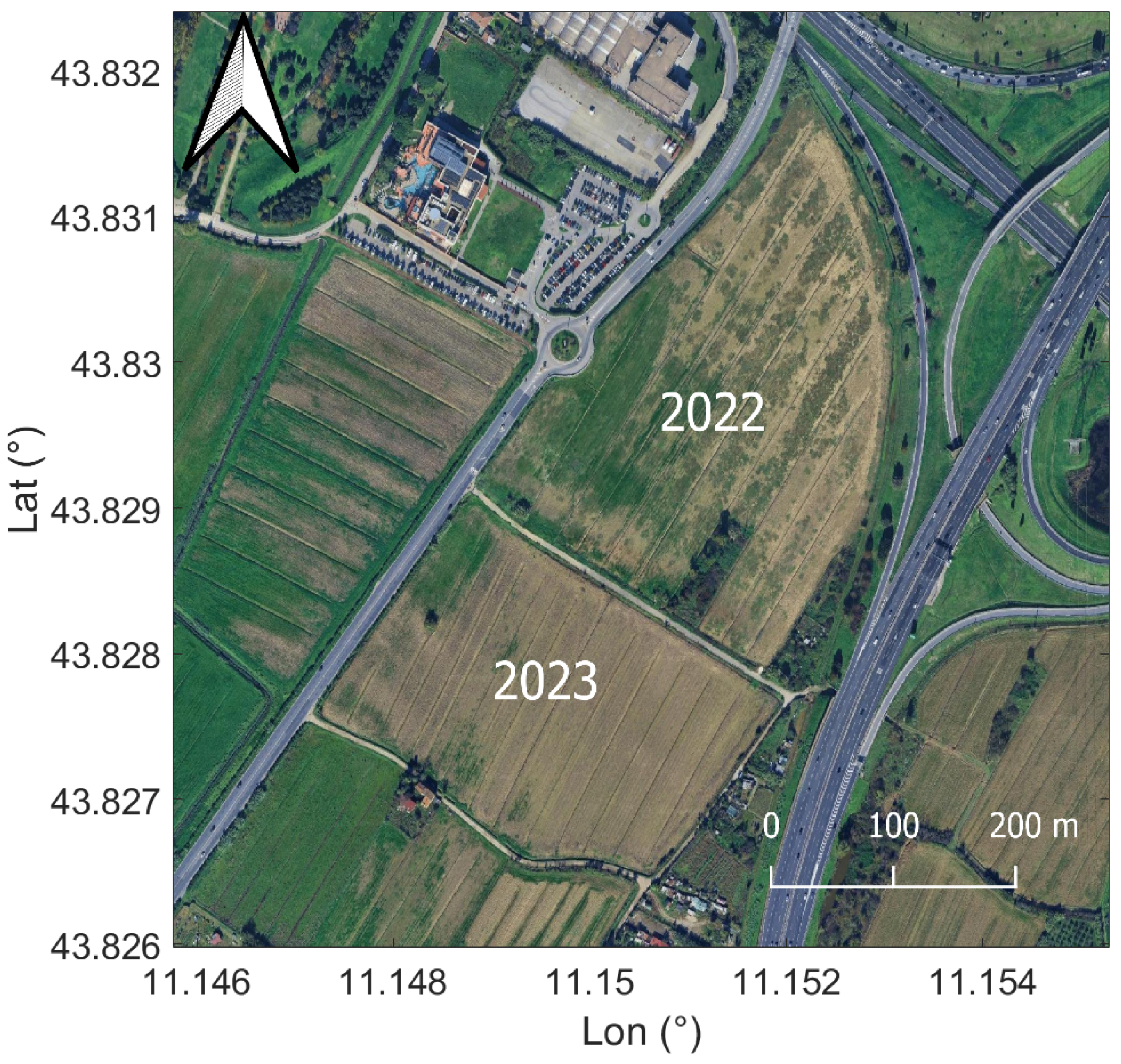
2.1. Test Area
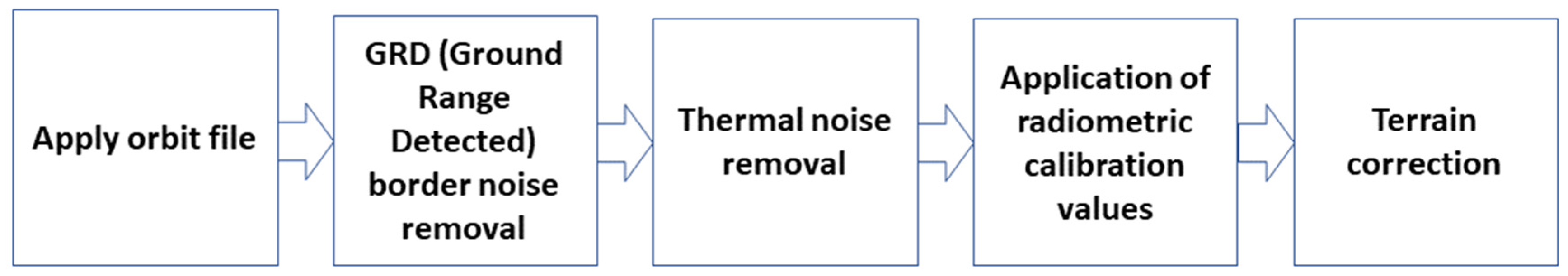
2.2. Satellite Data
2.3. In Situ Measurements
2.4. Electromagnetic Models
3. Results
4. Discussion
5. Conclusions
Author Contributions
Funding
Data Availability Statement
Conflicts of Interest
References
- Furtak, K.; Wolińska, A. The impact of extreme weather events as a consequence of climate change on the soil moisture and on the quality of the soil environment and agriculture—A review. Catena 2023, 231, 107378. [Google Scholar] [CrossRef]
- Donati II, M.; Viaggi, D.; Srdjevic, Z.; Srdjevic, B.; Di Fonzo, A.; Del Giudice, T.; Cimino, O.; Martelli, A.; Dalla Marta, A.; Henke, R.; et al. An analysis of preference weights and setting priorities by irrigation advisory services users based on the analytic hierarchy process. Agriculture 2023, 13, 1545. [Google Scholar] [CrossRef]
- Della Rocca, F.; De Feis, I.; Masiello, G.; Pasquariello, P.; Serio, C. Comparison of the IASI water deficit index and other vegetation indices: The case study of the intense 2022 drought over the Po Valley. In Remote Sensing of Clouds and the Atmosphere XXVIII; SPIE: Bellingham, WA, USA, 2023; Volume 12730, pp. 94–107. [Google Scholar]
- Farooq, A.; Farooq, N.; Akbar, H.; Hassan, Z.U.; Gheewala, S.H. A critical review of climate change impact at a global scale on cereal crop production. Agronomy 2023, 13, 162. [Google Scholar] [CrossRef]
- Ramat, G.; Santi, E.; Paloscia, S.; Fontanelli, G.; Pettinato, S.; Santurri, L.; Souissi, N.; Da Ponte, E.; Abdel Wahab, M.M.; Khalil, A.A.; et al. Remote sensing techniques for water management and climate change monitoring in drought areas: Case studies in Egypt and Tunisia. Eur. J. Remote Sens. 2023, 56, 2157335. [Google Scholar]
- FAO. FAO Publications Catalogue 2023; FAO: Rome, Italy, 2023. [Google Scholar] [CrossRef]
- Tian, J.; Zhang, Z.; Philpot, W.D.; Tian, Q.; Zhan, W.; Xi, Y.; Wang, Y.; Zhu, C. Simultaneous estimation of fractional cover of photosynthetic and non-photosynthetic vegetation using visible-near infrared satellite imagery. Remote Sens. Environ. 2023, 290, 113549. [Google Scholar] [CrossRef]
- Thenkabail, P.S.; Smith, R.B.; De Pauw, E. Hyperspectral vegetation indices and their relationships with agricultural crop characteristics. Remote Sens. Environ. 2000, 71, 158–182. [Google Scholar]
- Harries, J.; Carli, B.; Rizzi, R.; Serio, C.; Mlynczak, M.; Palchetti, L.; Maestri, T.; Brindley, H.; Masiello, G. The far-infrared Earth. Rev. Geophys. 2008, 46. [Google Scholar] [CrossRef]
- Wolanin, A.; Camps-Valls, G.; Gómez-Chova, L.; Mateo-García, G.; van der Tol, C.; Zhang, Y.; Guanter, L. Estimating crop primary productivity with Sentinel-2 and Landsat 8 using machine learning methods trained with radiative transfer simulations. Remote Sens. Environ. 2019, 225, 441–457. [Google Scholar]
- Murino, L.; Amato, U.; Carfora, M.F.; Antoniadis, A.; Huang, B.; Menzel, W.P.; Serio, C. Cloud detection of MODIS multispectral images. J. Atmos. Ocean. Technol. 2014, 31, 347–365. [Google Scholar]
- Paloscia, S.; Santi, E.; Fontanelli, G.; Montomoli, F.; Brogioni, M.; Macelloni, G.; Pampaloni, P.; Pettinato, S. The sensitivity of COSMO-SkyMed backscatter to agricultural crop type and vegetation parameters. IEEE J. Sel. Top. Appl. Earth Obs. Remote Sens. 2014, 7, 2856–2868. [Google Scholar]
- Santi, E.; Paloscia, S.; Pettinato, S.; Fontanelli, G.; Mura, M.; Zolli, C.; Maselli, F.; Chiesi, M.; Bottai, L.; Chirici, G. The potential of multifrequency SAR images for estimating forest biomass in Mediterranean areas. Remote Sens. Environ. 2017, 200, 63–73. [Google Scholar] [CrossRef]
- Macelloni, G.; Paloscia, S.; Pampaloni, P.; Marliani, F.; Gai, M. The relationship between the backscattering coefficient and the biomass of narrow and broad leaf crops. IEEE Trans. Geosci. Remote Sens. 2001, 39, 873–884. [Google Scholar] [CrossRef]
- Paloscia, S.; Pettinato, S.; Santi, E.; Notarnicola, C.; Pasolli, L.; Reppucci, A. Soil moisture mapping using Sentinel-1 images: Algorithm and preliminary validation. Remote Sens. Environ. 2013, 134, 234–248. [Google Scholar]
- Khati, U.; Lavalle, M.; Singh, G. The role of time-series L-band SAR and GEDI in mapping sub-tropical above-ground biomass. Front. Earth Sci. 2021, 9, 752254. [Google Scholar]
- Hensley, S.; Van Zyl, J.; Lavalle, M.; Neumann, M.; Michel, T.; Muellerschoen, R.; Pinto, N.; Simard, M.; Moghaddam, M. L-band and P-band studies of vegetation at JPL. In Proceedings of the 2015 IEEE Radar Conference, Johannesburg, South Africa, 27–30 October 2015; pp. 516–520. [Google Scholar]
- Potin, P.; Rosich, B.; Grimont, P.; Miranda, N.; Shurmer, I.; O’Connell, A.; Torres, R.; Krassenburg, M. Sentinel-1 mission status. In Proceedings of the EUSAR 2016: 11th European Conference on Synthetic Aperture Radar, Hamburg, Germany, 6–9 June 2016; pp. 1–6. [Google Scholar]
- Segarra, J.; Buchaillot, M.L.; Araus, J.L.; Kefauver, S.C. Remote sensing for precision agriculture: Sentinel-2 improved features and applications. Agronomy 2020, 10, 641. [Google Scholar] [CrossRef]
- Xue, J.; Su, B. Significant remote sensing vegetation indices: A review of developments and applications. J. Sens. 2017, 2017, 1353691. [Google Scholar] [CrossRef]
- Gamon, J.A.; Penuelas, J.; Field, C.B. A narrow-waveband spectral index that tracks diurnal changes in photosynthetic efficiency. Remote Sens. Environ. 1992, 41, 35–44. [Google Scholar]
- Peñuelas, J.; Filella, I.; Gamon, J.A. Assessment of photosynthetic radiation-use efficiency with spectral reflectance. New Phytol. 1995, 131, 291–296. [Google Scholar]
- Garbulsky, M.F.; Peñuelas, J.; Gamon, J.; Inoue, Y.; Filella, I. The photochemical reflectance index (PRI) and the remote sensing of leaf, canopy and ecosystem radiation use efficiencies: A review and meta-analysis. Remote Sens. Environ. 2011, 115, 281–297. [Google Scholar] [CrossRef]
- Zhang, C.; Filella, I.; Garbulsky, M.F.; Peñuelas, J. Affecting factors and recent improvements of the photochemical reflectance index (PRI) for remotely sensing foliar, canopy and ecosystemic radiation-use efficiencies. Remote Sens. 2016, 8, 677. [Google Scholar] [CrossRef]
- Gamon, J.A.; Kovalchuck, O.; Wong CY, S.; Harris, A.; Garrity, S.R. Monitoring seasonal and diurnal changes in photosynthetic pigments with automated PRI and NDVI sensors. Biogeosciences 2015, 12, 4149–4159. [Google Scholar] [CrossRef]
- Garbulsky, M.F. Remote estimation of carbon dioxide uptake of terrestrial ecosystems. Nat. Preced. 2007. [Google Scholar] [CrossRef]
- Zarco-Tejada, P.J.; Hornero, A.; Hernández-Clemente, R.; Beck, P.S.A. Understanding the temporal dimension of the red-edge spectral region for forest decline detection using high-resolution hyperspectral and Sentinel-2a imagery. ISPRS J. Photogramm. Remote Sens. 2018, 137, 134–148. [Google Scholar] [CrossRef]
- Mateo-Sanchis, A.; Piles, M.; Muñoz-Marí, J.; Adsuara, J.E.; Pérez-Suay, A.; Camps-Valls, G. Synergistic integration of optical and microwave satellite data for crop yield estimation. Remote Sens. Environ. 2019, 234, 111460. [Google Scholar] [CrossRef]
- Attema EP, W.; Ulaby, F.T. Vegetation modeled as a water cloud. Radio Sci. 1978, 13, 357–364. [Google Scholar] [CrossRef]
- Baghdadi, N.; El Hajj, M.; Zribi, M.; Bousbih, S. Calibration of the water cloud model at C-band for winter crop fields and grasslands. Remote Sens. 2017, 9, 969. [Google Scholar] [CrossRef]
- Gao, Q.; Zribi, M.; Escorihuela, M.J.; Baghdadi, N. Synergetic use of Sentinel-1 and Sentinel-2 data for soil moisture mapping at 100 m resolution. Sensors 2017, 17, 1966. [Google Scholar] [CrossRef] [PubMed]
- Bao, X.; Zhang, R.; He, X.; Shama, A.; Yin, G.; Chen, J.; Zhang, H.; Liu, G. An Integrated Time-Series Relative Soil Moisture Monitoring Method Based on a SAR Backscattering Model. IEEE J. Sel. Top. Appl. Earth Obs. Remote Sens. 2024, 18, 2137–2156. [Google Scholar] [CrossRef]
- Santi, E.; Paloscia, S.; Pettinato, S.; Entekhabi, D.; Alemohammad, S.H.; Konings, A.G. Integration of passive and active microwave data from SMAP, AMSR2 and Sentinel-1 for Soil Moisture monitoring. In Proceedings of the 2016 IEEE International Geoscience and Remote Sensing Symposium (IGARSS), Beijing, China, 10–15 July 2016; pp. 5252–5255. [Google Scholar]
- Fung, A.K. Microwave Scattering and Emission Models and Their Applications; Artech House Publishers: London, UK, 1994. [Google Scholar]
- Oh, Y.; Sarabandi, K.; Ulaby, F.T. An empirical model and an inversion technique for radar scattering from bare soil surfaces. IEEE Trans. Geosci. Remote Sens. 1992, 30, 370–381. [Google Scholar] [CrossRef]
- Dobson, M.C.; Ulaby, F.T.; Hallikainen, M.T.; El-Rayes, M.A. Microwave dielectric behavior of wet soil-Part II: Dielectric mixing models. IEEE Trans. Geosci. Remote Sens. 1985, 23, 35–46. [Google Scholar] [CrossRef]
- Pilia, S.; Fontanelli, G.; Santurri, L.; Ramat, G.; Baroni, F.; Santi, E.; Lapini, A.; Pettinato, S.; Paloscia, S. Data integration of Sentinel-1 and Sentinel-2 for evaluating vegetation biomass and water status. In Proceedings of the 2023 IEEE International Workshop on Metrology for Agriculture and Forestry (MetroAgriFor), Pisa, Italy, 6–8 November 2023; pp. 694–698. [Google Scholar]
- Pilia, S.; Baroni, F.; Fontanelli, G.; Ramat, G.; Palchetti, E.; Paloscia, S.; Pettinato, S.; Santi, E.; Santurri, L. Soil and Vegetation Water Status Monitoring by Integrating Optical and Microwave Satellite Data. In Proceedings of the IGARSS 2024-2024 IEEE International Geoscience and Remote Sensing Symposium, Athens, Greece, 7–12 July 2024; pp. 1470–1473. [Google Scholar]
- Available online: https://world-soils.com/ (accessed on 30 August 2024).
- Available online: https://www.esa.int/Applications/Observing_the_Earth/Copernicus/Sentinel-1/Mission_ends_for_Copernicus_Sentinel-1B_satellite (accessed on 26 April 2025).
- Barnes, E.M.; Clarke, T.R.; Richards, S.E.; Colaizzi, P.D.; Haberland, J.; Kostrzewski, M.; Waller, P.; Choi, C.; Riley, E.; Thompson, T.; et al. Coincident detection of crop water stress, nitrogen status and canopy density using ground based multispectral data. In Proceedings of the Fifth International Conference on Precision Agriculture, Bloomington, MN, USA, 16–19 July 2000; Volume 1619. No. 6. [Google Scholar]
- Gamon, J.A.; Surfus, J.S. Assessing leaf pigment content and activity with a reflectometer. New Phytol. 1999, 143, 105–117. [Google Scholar] [CrossRef]
- Merzlyak, M.N.; Gitelson, A.A.; Chivkunova, O.B.; Rakitin, V.Y. Non-destructive optical detection of pigment changes during leaf senescence and fruit ripening. Physiol. Plant. 1999, 106, 135–141. [Google Scholar] [CrossRef]
- Penuelas, J.; Baret, F.; Filella, I. Semi-empirical indices to assess carotenoids/chlorophyll a ratio from leaf spectral reflectance. Photosynthetica 1995, 31, 221–230. [Google Scholar]
- Gorelick, N.; Hancher, M.; Dixon, M.; Ilyushchenko, S.; Thau, D.; Moore, R. Google Earth Engine: Planetary-scale geospatial analysis for everyone. Remote Sens. Environ. 2017, 202, 18–27. [Google Scholar] [CrossRef]
- Clemente, J.P.; Fontanelli, G.; Ovando, G.G.; Roa, Y.L.B.; Lapini, A.; Santi, E. Google Earth Engine: Application of algorithms for remote sensing of crops in Tuscany (Italy). In Proceedings of the 2020 IEEE Latin American GRSS & ISPRS Remote Sensing Conference (LAGIRS), Santiago, Chile, 22–26 March 2020; pp. 195–200. [Google Scholar]
- Cai, Y.; Zhang, M.; Lin, H. Estimating the urban fractional vegetation cover using an object-based mixture analysis method and Sentinel-2 MSI imagery. IEEE J. Sel. Top. Appl. Earth Obs. Remote Sens. 2020, 13, 341–350. [Google Scholar] [CrossRef]
- Andreatta, D.; Gianelle, D.; Scotton, M.; Dalponte, M. Estimating grassland vegetation cover with remote sensing: A comparison between Landsat-8, Sentinel-2 and PlanetScope imagery. Ecol. Indic. 2022, 141, 109102. [Google Scholar] [CrossRef]
- Available online: https://www.specmeters.com/FieldScout-TDR350-Soil-Moisture-Meter (accessed on 30 August 2024).
- Available online: https://handheld.psi.cz/products/plantpen-ndvi-and-pri/ (accessed on 30 August 2024).
- Konings, A.G.; Rao, K.; Steele-Dunne, S.C. Macro to micro: Microwave remote sensing of plant water content for physiology and ecology. New Phytol. 2019, 223, 1166–1172. [Google Scholar] [CrossRef]
- Ulaby, F.T.; Moore, R.K.; Fung, A.K. Microwave Remote Sensing: Active and Passive. Volume 2-Radar Remote Sensing and Surface Scattering and Emission Theory; NTRS: Hilversum, The Netherlands, 1982. [Google Scholar]
- Available online: https://www.lamma.toscana.it/meteo/osservazioni-e-dati/dati-stazioni (accessed on 26 April 2025).
- Takala, T.L.; Mõttus, M. Spatial variation of canopy PRI with shadow fraction caused by leaf-level irradiation conditions. Remote Sens. Environ. 2016, 182, 99–112. [Google Scholar] [CrossRef]
- Ouaadi, N.; Jarlan, L.; Ezzahar, J.; Khabba, S.; Le Dantec, V.; Rafi, Z.; Zribi, M.; Frison, P.L. Water stress detection over irrigated wheat crops in semi-arid areas using the diurnal differences of Sentinel-1 backscatter. In Proceedings of the 2020 Mediterranean and Middle-East Geoscience and Remote Sensing Symposium (M2GARSS), Tunis, Tunisia, 9–11 March 2020; pp. 306–309. [Google Scholar]
- Rockström, J.; Karlberg, L.; Wani, S.P.; Barron, J.; Hatibu, N.; Oweis, T.; Bruggeman, A.; Farahani, J.; Qiang, Z. Managing water in rainfed agriculture—The need for a paradigm shift. Agric. Water Manag. 2010, 97, 543–550. [Google Scholar] [CrossRef]
- Available online: https://joint-research-centre.ec.europa.eu/european-and-global-drought-observatories/current-drought-situation-europe_en (accessed on 3 September 2024).
- Amiri, M.A.; Gocic, M. Analysis of temporal and spatial variations of drought over Serbia by investigating the applicability of precipitation-based drought indices. Theor. Appl. Climatol. 2023, 154, 261–274. [Google Scholar] [CrossRef]
- Edwards, B.; Gray, M.; Hunter, B. The social and economic impacts of drought. Aust. J. Soc. Issues 2019, 54, 22–31. [Google Scholar] [CrossRef]
- Dotzler, S.; Hill, J.; Buddenbaum, H.; Stoffels, J. The potential of EnMAP and Sentinel-2 data for detecting drought stress phenomena in deciduous forest communities. Remote Sens. 2015, 7, 14227–14258. [Google Scholar] [CrossRef]
- Baup, F.; Fieuzal, R.; Ygorra, B.; Frappart, F.; Riazanoff, S.; Martin-Comte, A.; Gorrab, A. 6-Years of Sar (Sentinel-1) and Optical (Sentinel 2, Landsat-8) Acquisitions Over Agricultural Surfaces in Southwestern, France. 2025. Available online: https://papers.ssrn.com/sol3/papers.cfm?abstract_id=5078835 (accessed on 26 April 2025).


| S-1 Orbit | Angle of Incidence [deg] | Overpass Time [UTC] |
|---|---|---|
| 117-Ascending | 34.20 | 17:06 |
| 15-Ascending | 43.82 | 17:14 |
| 95-Descending | 43.18 | 05:19 |
| 168-Descending | 33.20 | 05:27 |
| Index | Formula | Reference |
|---|---|---|
| NDRE | [41] | |
| RGR | [42] | |
| PSRI | [43] | |
| SIPI | [44] |
| Date S-1 | Date S-2 | Type of Orbit |
|---|---|---|
| 07/07/2022 | 07/07/2022 | Descending |
| 14/07/2022 | 12/07/2022 | Descending |
| 19/07/2022 | 17/07/2022 | Descending |
| 20/07/2022 | 22/07/2022 | Ascending |
| 27/07/2022 | 27/07/2022 | Ascending |
| 01/08/2022 | 01/08/2022 | Ascending |
| 08/08/2022 | 06/08/2022 | Ascending |
| 13/08/2022 | 16/08/2022 | Ascending |
| 25/08/2022 | 26/08/2022 | Ascending |
| 31/08/2022 | 31/08/2022 | Descending |
| 27/07/2023 | 27/07/2023 | Ascending |
| 15/08/2023 | 16/08/2023 | Ascending |
| 26/08/2023 | 26/08/2023 | Descending |
| 07/09/2023 | 05/09/2023 | Descending |
| 12/09/2023 | 10/09/2023 | Descending |
| 13/09/2023 | 15/09/2023 | Ascending |
| 25/09/2023 | 25/09/2023 | Ascending |
| 01/10/2023 | 30/09/2023 | Descending |
| Index | Regressions | R2 |
|---|---|---|
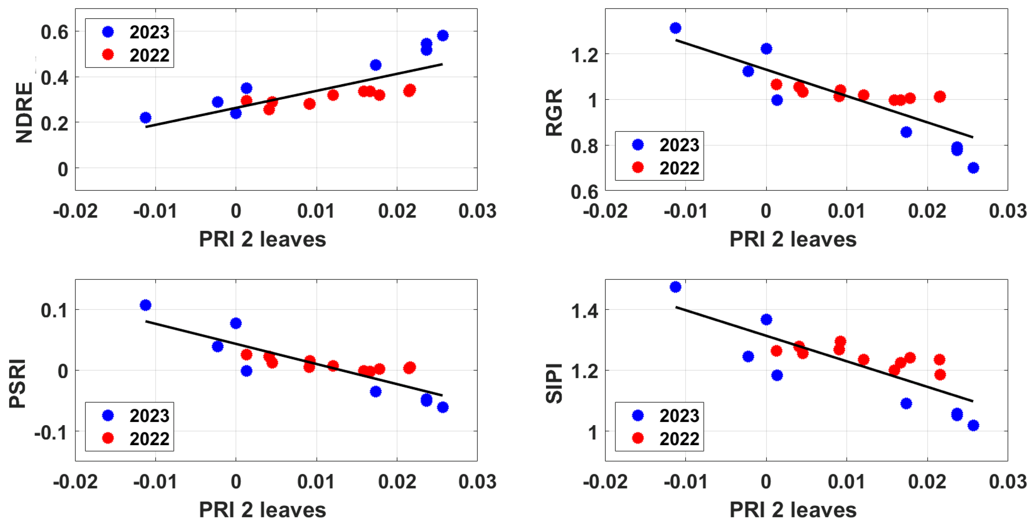
| NDRE | 7.4594·PRI + 0.2634 | 0.58 |
| RGR | −11.571·PRI + 1.1308 | 0.70 |
| PSRI | −3.3099·PRI + 0.0434 | 0.73 |
| SIPI | −8.4102·PRI + 1.3135 | 0.64 |
| Index | Fitting | R2 |
|---|---|---|
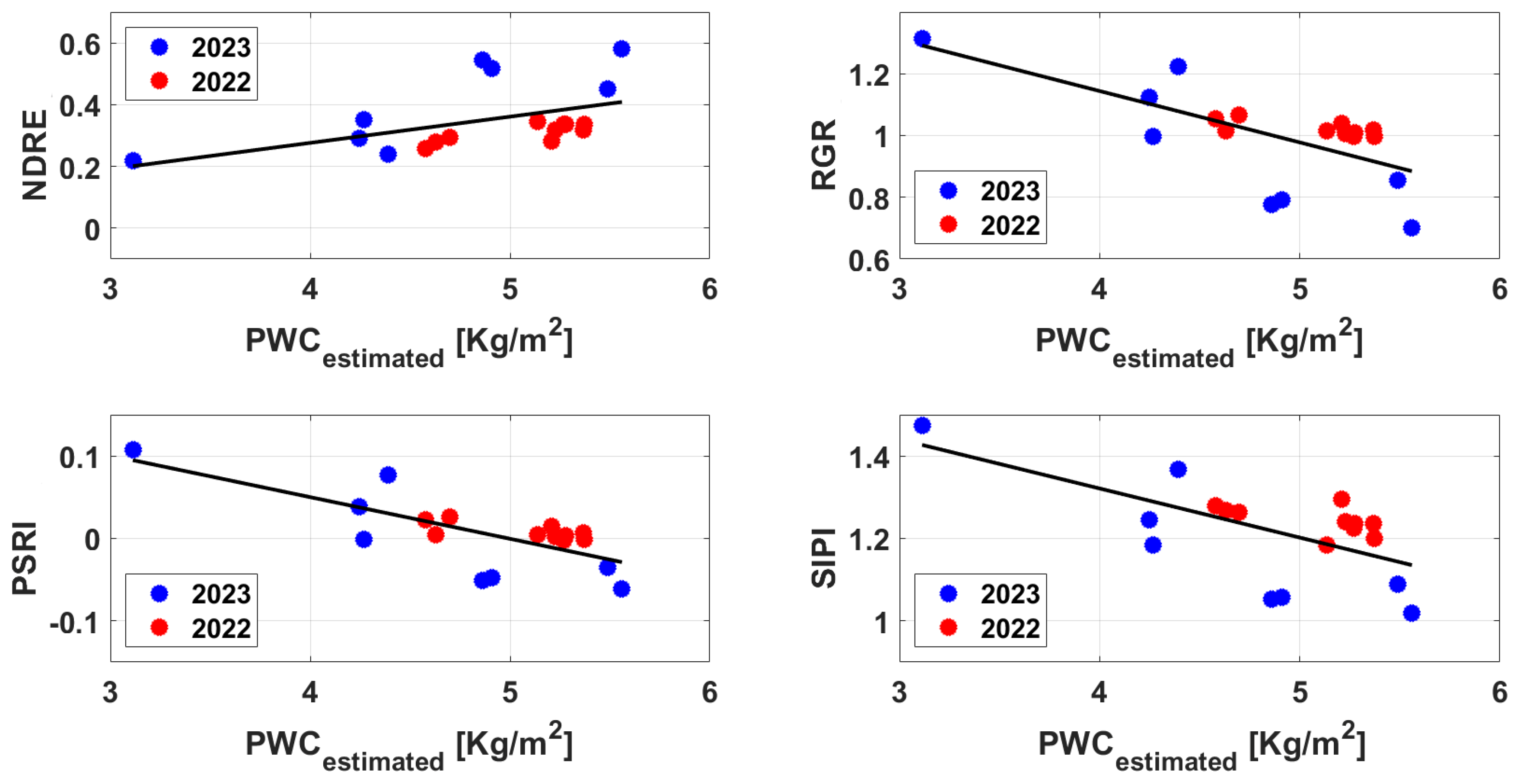
| NDRE | 3.9302·PRI + 0.3136 | 0.43 |
| RGR | −6.9413·PRI + 1.06 | 0.67 |
| PSRI | −2.0475·PRI + 0.0236 | 0.75 |
| SIPI | −5.0091·PRI + 1.2618 | 0.61 |
| Index | Fitting | R2 |
|---|---|---|
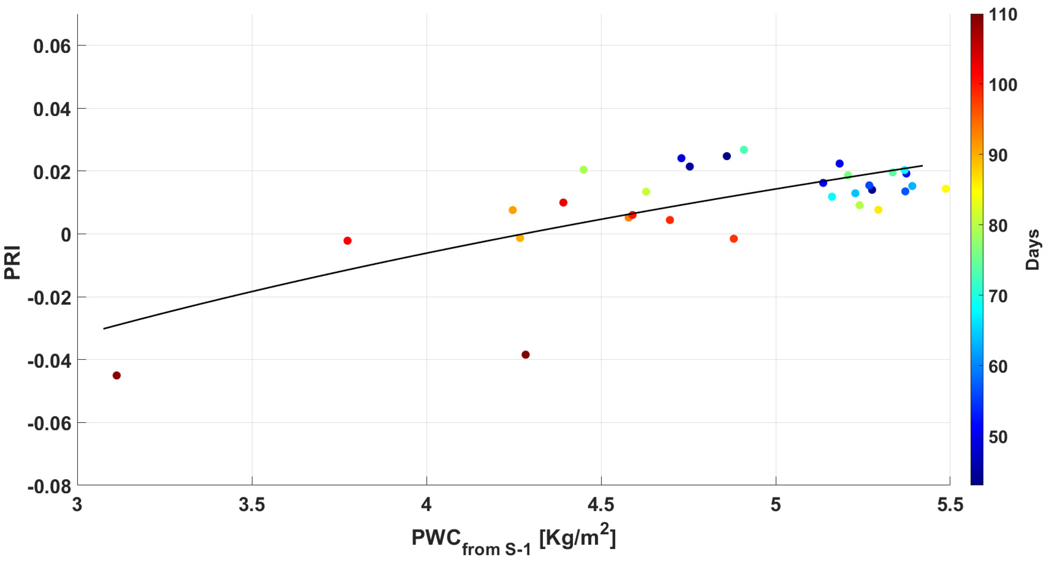
| NDRE | 0.0849∙PWC − 0.0634 | 0.24 |
| RGR | −0.1664∙PWC + 1.8097 | 0.46 |
| PSRI | −0.0505∙PWC + 0.2521 | 0.54 |
| SIPI | −0.1191∙PWC + 1.7976 | 0.41 |
Disclaimer/Publisher’s Note: The statements, opinions and data contained in all publications are solely those of the individual author(s) and contributor(s) and not of MDPI and/or the editor(s). MDPI and/or the editor(s) disclaim responsibility for any injury to people or property resulting from any ideas, methods, instructions or products referred to in the content. |
© 2025 by the authors. Licensee MDPI, Basel, Switzerland. This article is an open access article distributed under the terms and conditions of the Creative Commons Attribution (CC BY) license (https://creativecommons.org/licenses/by/4.0/).
Share and Cite
Pilia, S.; Fontanelli, G.; Santurri, L.; Palchetti, E.; Ramat, G.; Baroni, F.; Santi, E.; Lapini, A.; Pettinato, S.; Paloscia, S. Integration of Optical and Microwave Satellite Data for Monitoring Vegetation Status in Sorghum Fields. Remote Sens. 2025, 17, 1591. https://doi.org/10.3390/rs17091591
Pilia S, Fontanelli G, Santurri L, Palchetti E, Ramat G, Baroni F, Santi E, Lapini A, Pettinato S, Paloscia S. Integration of Optical and Microwave Satellite Data for Monitoring Vegetation Status in Sorghum Fields. Remote Sensing. 2025; 17(9):1591. https://doi.org/10.3390/rs17091591
Chicago/Turabian StylePilia, Simone, Giacomo Fontanelli, Leonardo Santurri, Enrico Palchetti, Giuliano Ramat, Fabrizio Baroni, Emanuele Santi, Alessandro Lapini, Simone Pettinato, and Simonetta Paloscia. 2025. "Integration of Optical and Microwave Satellite Data for Monitoring Vegetation Status in Sorghum Fields" Remote Sensing 17, no. 9: 1591. https://doi.org/10.3390/rs17091591
APA StylePilia, S., Fontanelli, G., Santurri, L., Palchetti, E., Ramat, G., Baroni, F., Santi, E., Lapini, A., Pettinato, S., & Paloscia, S. (2025). Integration of Optical and Microwave Satellite Data for Monitoring Vegetation Status in Sorghum Fields. Remote Sensing, 17(9), 1591. https://doi.org/10.3390/rs17091591