Abstract
Thermodynamic and liquid water profiles can be retrieved by a ground-based microwave radiometer (MWR) in nearly all weather conditions, which is useful for detecting mesoscale phenomena. This paper reviews the advances in remote sensing of atmospheric profiles and cloud properties by MWR in central China. Comparative studies indicate that MWR retrieval accuracy is different under various skies, especially those that decay under precipitation. The off-zenith method is proven to be capable of reducing the impact of precipitation and snow on MWR retrieval accuracy. Application studies demonstrate that MWR retrievals are helpful for early warning of rainstorms, hailstorms, and thunderstorms. Moreover, MWR retrievals provide a way to study cloud properties. The temporal variations of cloud occurrence frequency (COF) and liquid water path (LWP) are different for low, middle, and high clouds, and the vertical distribution of COF is also different in autumn and other seasons. Note that MWR can infer valid retrievals over the eastern Tibetan Plateau due to the weak precipitation over there. Also, cloud properties over the eastern Tibetan Plateau present differences from those over central China, and this is related to the different characteristics of atmospheric water vapor between these two regions. To bring more benefits for mechanism study and early warning of severe weather and numerical weather prediction, the decayed accuracy of MWR zenith retrievals under precipitation should be resolved. And combining MWR with other instruments is necessary for MWR application in detecting multi-layer clouds and ice clouds.
1. Introduction
Atmospheric profiles are essential in meteorological studies and are mainly obtained from radiosonde sounding, which is generally released twice daily at 00 and 12 UTC. However, the temporal resolution of radiosonde observation is insufficient for studies of mesoscale phenomena. A ground-based microwave radiometer (MWR) can retrieve atmospheric profiles from atmospheric radiation in the microwave band. Most MWRs operate in the frequency range of 20–60 GHz with wavelengths ranging from 0.5 cm to 1.5 cm, because in this frequency range, atmospheric thermal emission is closely related to atmospheric temperature, humidity, and hydrometeors [1,2]. As a passive remote sensing instrument, MWR measures the natural down-welling thermal emission originating from Earth’s atmosphere and the cosmic background in its operating frequency range. The radiance observations are usually expressed as an equivalent brightness temperature. By using the brightness temperatures from oxygen absorption at 55–60 GHz, atmospheric temperature profiles are estimated, and the brightness temperatures from water vapor absorption at around 22 GHz are used in estimating atmospheric humidity profiles. Also, low-resolution cloud liquid water content (LWC) profiles can be inferred by using the brightness temperatures at 22–59 GHz together with a cloud base height (CBH) measurement. Finally, with these thermodynamic and LWC profiles, the column-integrated water vapor (IWV) and liquid water path (LWP) can be derived [3,4,5,6,7]. Studies show that MWR-retrieved profiles have compatible accuracy with most meteorology applications, especially in the lower troposphere [8,9,10,11]. Moreover, MWR-retrieved profiles are available with minute-level temporal resolution under nearly all weather conditions, and this is very useful for the detection of mesoscale phenomena that require very high spatial and temporal scales [1,12,13,14]. Furthermore, because the emission of clouds is proportional to the water volume, remote sensing by MWR is proven to be an accurate method for deriving the vertical integral of LWC, i.e., integrated liquid water (ILW) or LWP [15,16,17], and this provides a way to study clouds. Therefore, MWR retrievals have high spatiotemporal resolution, which can compensate for the shortcomings of coarse temporal resolution in radiosonde observation, so MWRs are widely being established in many countries for climate, weather, numerical weather prediction, and other meteorology applications [1,2,3,13,18,19].
Since MWR is a remote sensing instrument and its retrieval of atmospheric profiles is based on neural networks trained by local historical radiosonde observation [3], it is necessary to verify MWR retrieval accuracy in the region where MWR is located, especially under different skies. Moreover, the off-zenith method is suggested to provide higher accuracy for MWR retrievals during precipitation by weakening the impact of liquid water and ice on the radome of MWR [11], yet few studies are reported on statistical comparison between MWR retrievals in the off-zenith method and radiosondes, so quantitative evaluation of MWR retrieval accuracy in the off-zenith method helps to better understand the effect of the off-zenith method on reducing the impact of precipitation. Furthermore, although MWR retrievals have been gradually applied to severe weather research [1,12,13], few progresses in this area were reported in China before 2010, and there are also few MWR applications in studying cloud properties. This is because the widespread deployment of MWR in China is relatively late. In central China, several MWRs have been gradually deployed since 2008 by the Institute of Heavy Rain (IHR), China Meteorological Administration, Wuhan. The off-zenith method is adopted in MWR retrieval for the first time in China, which opens the door to conducting the studies mentioned above in the involved region.
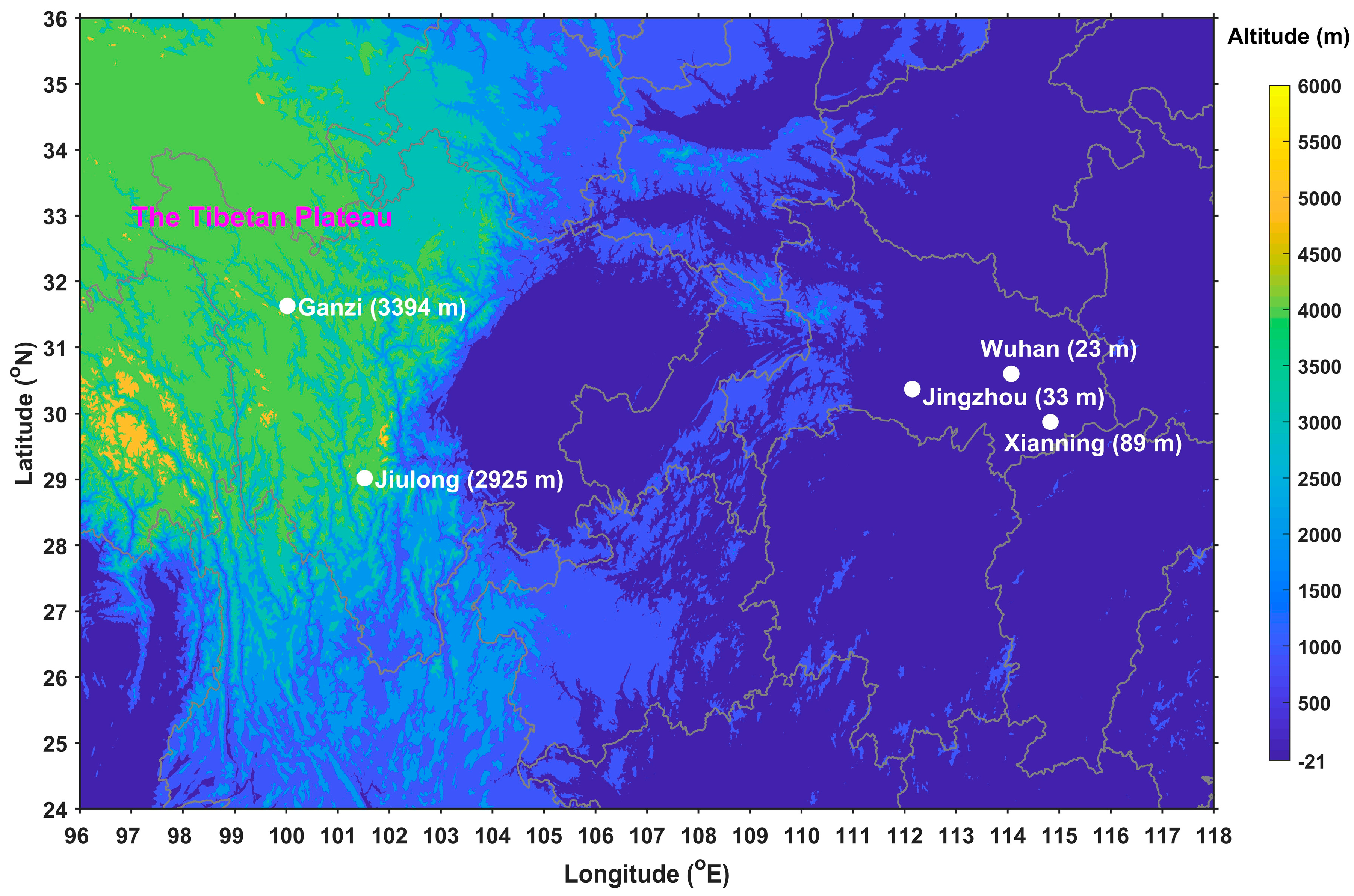
As shown in Figure 1, three MWRs have been gradually established at Wuhan (114.1°E, 30.6°N), Xianning (114.3°E, 29.8°N), and Jingzhou (112.2°E, 30.3°N) in central China since 2008 by IHR, aiming to detect atmospheric fine thermal profiles and cloud properties of cloud precipitation systems [20]. Moreover, IHR established two MWRs at Ganzi (31.6°N, 100.0°E) and Jiulong (29.0°N, 101.5°E) in the eastern Tibetan Plateau (Figure 1) in the summers of 2017–2020, also aiming to detect atmospheric fine thermal profiles and cloud properties over there [21] and conduct comparisons with those over central China. All five MWRs are units of the MP-3000A, manufactured by the Radiometrics Corporation of the USA [3,22]. This unit of MWR observes atmospheric radiation at 21 K-band (22–30 GHz) and 14 V-band (51–59 GHz) microwave channels at multiple elevation angles, equipped with a zenith-looking infrared thermometer (IRT, operating at 9.6–11.5 μm) and surface temperature, humidity, and pressure sensors. These observations, including microwave, infrared, and surface meteorological measurements, are automatically inputted into pretrained neural networks as input parameters and then converted into atmospheric temperature, vapor density, relative humidity, and LWC profiles, as well as IWV and LWP [3,11]. Historical radiosondes are used to characterize atmospheric states at a particular location in the training of neural networks. The radiosondes are also applied to forward model brightness temperatures incident at ground level for each radiosonde sounding by radiative transfer equations, which are also used in the training of neural networks. Since radiosonde soundings do not observe liquid water, an artificial value of liquid water is assigned in the radiosonde soundings at levels where humidity is close to saturation [23]. The zenith-looking IRT equipped on the MWR is used to observe atmospheric background temperature under a clear sky and cloud base temperature under a cloudy sky. Then CBH can be set to the lowest height where the cloud base temperature from IRT is equal to the contemporaneous MWR-retrieved temperature profile [3]. The vertical resolution of MWR retrieval profiles is set to 50 m at the heights of 0–500 m, 100 m at the heights of 500–2000 m, and 250 m at the heights of 2000–10,000 m, with a temporal resolution of ~3 min [3,22]. Using the observation of the above five MWRs, studies on the validation and application of MWR in the involved region are continuously conducted.
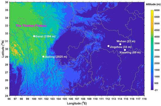
Figure 1.
Locations and altitudes of the three MWR sites (Wuhan, Xianning, and Jingzhou) in central China and the two MWR sites (Ganzi and Jiulong) in the eastern Tibetan Plateau.
This paper aims to review the advances in remote sensing of atmospheric profiles and cloud properties by MWR in central China. Section 2 introduces the accuracies of MWR-retrieved atmospheric profiles under various sky conditions, while reducing precipitation impact on MWR retrieval accuracy by the off-zenith method is presented in Section 3. Section 4 introduces the application of MWR retrievals in severe weather, followed by remote sensing of cloud properties by MWR in Section 5, and finally, the summary and outlook are given in Section 6.
2. Accuracies of MWR-Retrieved Atmospheric Profiles under Various Sky Conditions
Since MWR retrievals are derived from the observation of atmospheric thermal emission, it is necessary to validate the MWR retrieval accuracy under various sky conditions before conducting the application of MWR retrievals. Using the 3.5-year observations of MWR and radiosonde in Wuhan, Xu et al. (2015) [24] analyzed the MWR retrieval accuracy under clear and cloudy skies. The MWR-retrieved atmospheric profiles over a 1 h interval centered at radiosonde launching times (00 and 12 UTC) are averaged to couple with the radiosonde observation. Based on the coupled MWR and radiosonde profiles, the biases of MWR-retrieved temperature, vapor density, and relative humidity are their discrepancies against the coupled radiosonde observation, and the root mean square error (RMSE) is the standard deviation of the bias (the same below). It is found that, on the whole, MWR retrievals have a higher correlation coefficient with radiosondes under a cloudy sky than a clear sky; MWR temperature shows better bias and RMSE under a cloudy sky; and MWR vapor density and relative humidity show close accuracy under clear and cloudy skies (Table 1). However, considering the RMSE normalized by the mean (NRMSE), the NRMSE of MWR vapor density under a cloudy sky is 22%, smaller than the value of 48% under a clear sky. Moreover, MWR temperature presents a negative bias against radiosondes, and MWR relative humidity presents a wet bias. This is because radiosonde humidity has a systematic dry bias from solar heating while radiosonde temperature has a positive one [25,26,27], and due to less solar heating on the radiosonde sensors under a cloudy sky, the MWR temperature negative bias becomes smaller than that under a clear sky. With the comparison between MWR and radiosonde at each profile height, this result is safe at most profile heights, and MWR retrievals present better accuracy at lower levels than at upper levels because of more weighting functions at lower levels [28]. It is also found that the correlation coefficient between MWR and radiosonde temperatures decreases with height while the MWR temperature absolute bias and RMSE increase, which is suggested to be related to the increased wind speed and drifted distance of the sounding balloon. As shown in Figure 2, the MWR temperature bias presents a negative correlation with wind speed, with a correlation coefficient of −0.4856 under a cloudy sky and −0.7057 under a clear sky, respectively. When wind speed increases with height, the negative correlation between MWR temperature bias and wind speed also becomes significant. However, the biases of MWR vapor density and relative humidity present a weak correlation with wind speed. Additionally, based on available CBHs from IRT, Xu et al. (2015) [24] classified clouds into low, middle, and high clouds to explore MWR retrieval accuracy against radiosondes when different types of clouds exist, and for each type of cloud, the comparison between the whole MWR retrieval profile and radiosonde profile is conducted. For temperature comparison, the correlation coefficient between MWR and radiosonde is the highest for high clouds with the lowest bias and RMSE between them, but it is opposite for low clouds. For vapor density comparison, the correlation coefficient between MWR and radiosonde is the highest for middle clouds with the lowest bias between them, and high clouds have the lowest correlation coefficient and the largest bias and RMSE. Additionally, the NRMSE of MWR temperature is 34% when high clouds exist, smaller than the value of 49% for low clouds; although the bias of MWR vapor density is larger when high clouds exist than that for middle clouds, both of them have a NRSME of around 21%. It should be noted that due to the lack of cloud tops in MWR measurements, understanding the impact of clouds on MWR retrieval accuracy is limited, and to have better information about MWR performance when different types of clouds exist, future work with additional cloud top measurements is necessary.

Table 1.
Comparative results between MWR retrievals and radiosondes for all profile heights under clear and cloudy skies from June 2010 to December 2013 in Wuhan [24].
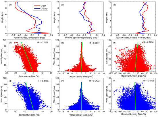
Figure 2.
Correlations between wind speed and the biases of MWR temperature (a,d,g), vapor density (b,e,h), and relative humidity (c,f,i) under clear (red) and cloudy (blue) skies from June 2010 to December 2013 in Wuhan. R is the correlation coefficient.
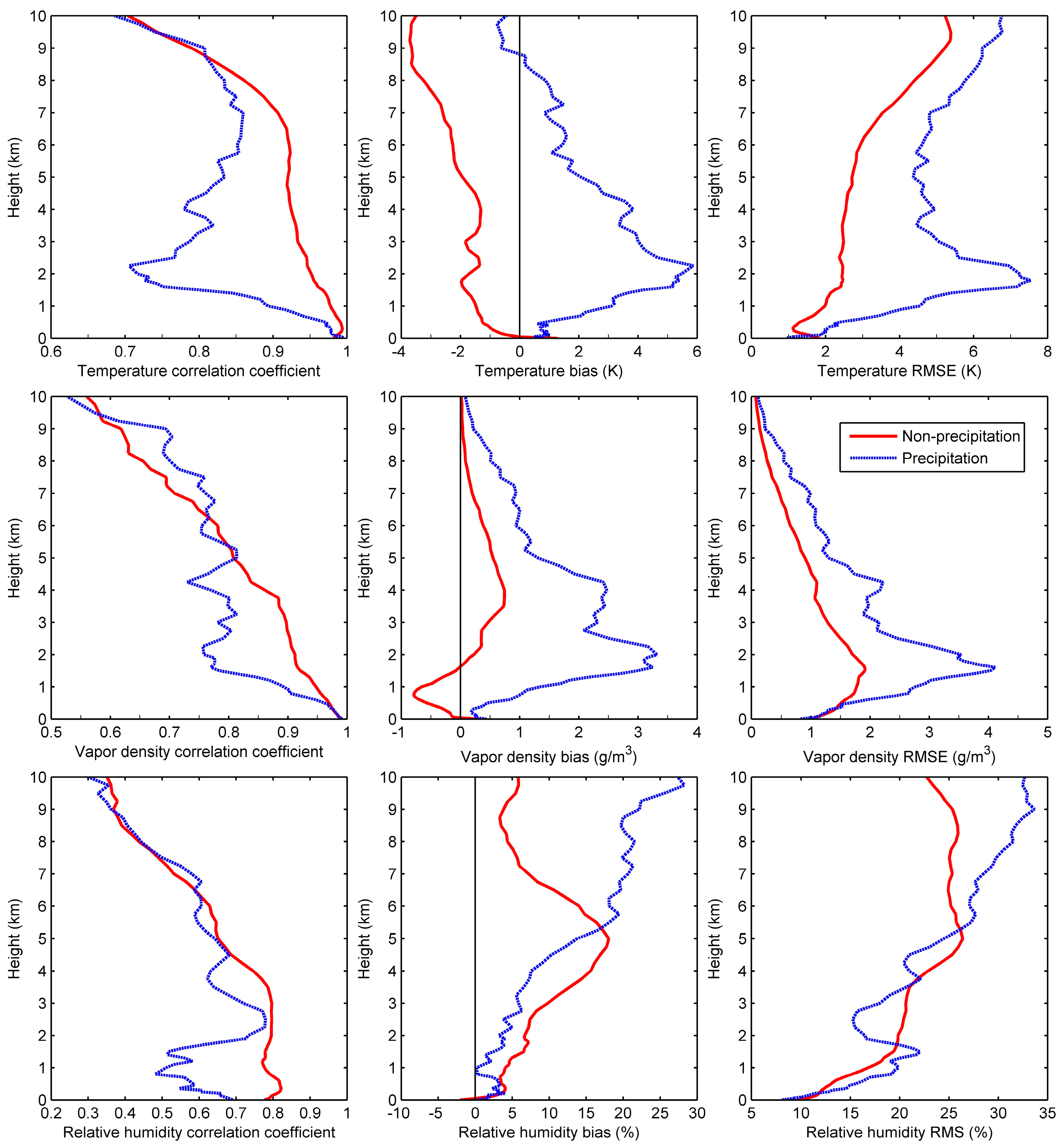
In the MWR retrieval principle, the scattering and emission/absorption effects of rain are usually not included, and the presence of a water film on the outer housing (radome) of the MWR may decay the performance of MWR retrievals under a precipitation sky; hence, MWR is mainly used under a non-precipitation sky [2,11,29]. Using the 3-year observations of MWR and radiosonde in Wuhan, Xu et al. (2014) [22] investigated the impact of precipitation on MWR retrieval accuracy. As shown in Table 2, the agreement between MWR retrievals and radiosondes is slightly weakened under a precipitation sky, and MWR retrieval accuracy becomes poor. Against radiosondes, MWR temperature bias is −1.9 K under a non-precipitation sky and becomes 2.1 K under a precipitation sky, with MWR temperature RMSE increasing from 3.2 K to 5.3 K. For vapor density, the bias of 1.31 g/m3 under precipitation sky is clearly greater than the bias of 0.06 g/m3 under non-precipitation sky, and the RMSE is the same situation; even the NRMSE of MWR vapor density is 45% under precipitation sky, greater than the value of 29% under non-precipitation sky. By contrast, the bias and RMSE of MWR relative humidity become slightly greater under a precipitation sky than under a non-precipitation sky. The insensitivity of the relative humidity bias to the sky condition may be related to the fact that relative humidity is artificially limited to less than 100% in radiosondes and MWR retrievals, which may benefit the agreement of relative humidity between MWR and radiosonde during saturated conditions. It is obvious that MWR retrieval accuracy decays under precipitation. The study of Xu et al. (2014) [22] also indicates that the impact of precipitation on MWR temperature is mostly significant around 2 km height, where MWR temperature presents a low-value peak of correlation coefficient with radiosondes but with high peaks of temperature bias and RMSE between them (Figure 3). It is the same situation for MWR vapor density. Also, the differences between the precipitation and non-precipitation cases are mostly statistically significant. However, the impact of precipitation on MWR relative humidity around 2 km height is not as significant as that for MWR temperature and vapor density. In addition, Zhang et al. (2014, 2017) [30,31] compared MWR retrievals with radiosondes in a 3 h temporal interval in Wuhan to check the diurnal variation of MWR retrieval discrepancy against radiosondes. It was found that MWR temperature has a relatively large deviation in the afternoon but in the early morning for MWR vapor density and relative humidity, and precipitation, especially heavy ones, has an impact on MWR retrieval accuracy.

Table 2.
Comparative results between MWR retrievals and radiosondes for all profile heights under non-precipitation and precipitation skies from June 2010 to April 2013 in Wuhan [22].
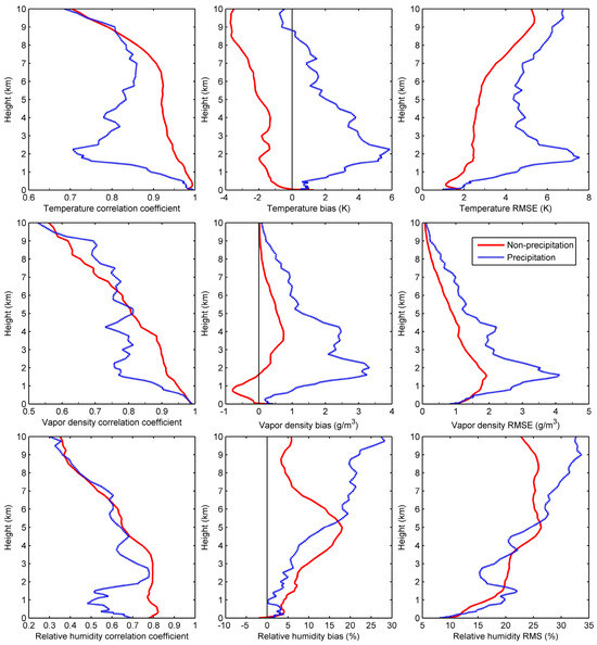
Figure 3.
Comparison of MWR temperature (top panels), vapor density (middle panels), and relative humidity (bottom panels) against radiosondes at each profile height under non-precipitation (red) and precipitation (blue) skies from June 2010 to April 2013 in Wuhan [22].
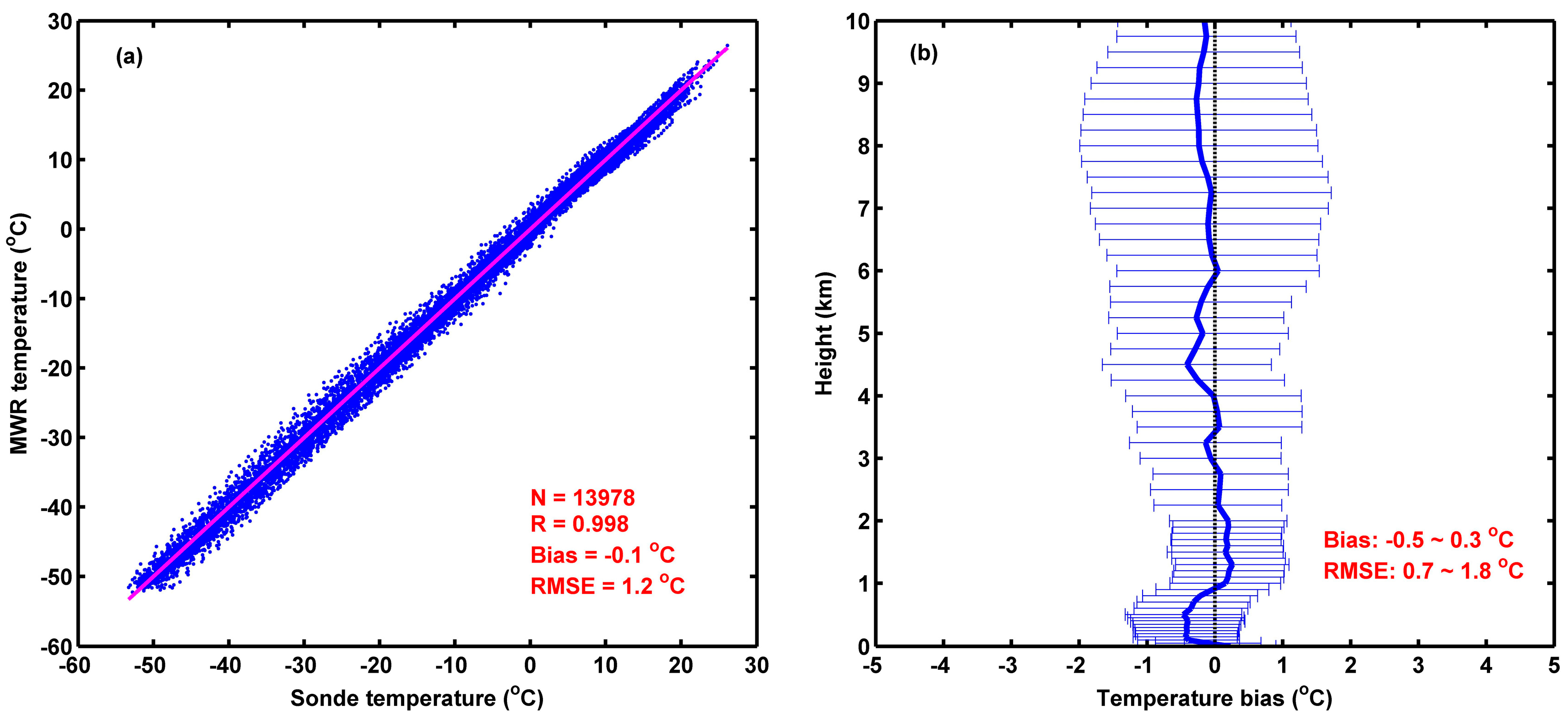
Although MWR is mainly used under non-precipitation, it is suggested that MWR can also infer valid retrievals in the presence of low-moderate precipitation, such as a rainfall rate less than 10 mm/h [2,29]. IHR conducted a field experiment in the warm season of 2017 at Ganzi in the eastern Tibetan Plateau to explore the applicability of MWR over there, where the rainfall rate is much lower than that in central China. For example, the maximum rainfall rate in Ganzi in the warm season of 2017 is 4.9 mm/h, while that in Wuhan is 49.2 mm/h. Using the observations of MWR and radiosonde in Ganzi, Xu et al. (2019) [21] investigated the MWR retrieval accuracy over there. As shown in Table 3, MWR temperature and relative humidity present close bias and RMSE against radiosondes in Ganzi under both non-precipitation and precipitation skies, and MWR vapor density even presents better bias and RMSE against radiosondes under precipitation skies. Compared to the results in central China (Table 2), the MWR retrieval accuracy is generally reasonable in the eastern Tibetan Plateau. Additionally, with the data of MWR and GPS radiosonde from June to July in 2018–2019 at Jiulong in eastern Tibetan Plateau, Xu et al. (2023) [32] analyzed the accuracy of MWR temperature under a cloudy sky. It is shown in Figure 4 that MWR temperature agrees well with GPS radiosondes, and MWR temperature bias has a mean value of −0.1 °C and varies with height in the range of −0.5 °C to 0.3 °C, while MWR temperature RMSE varies with height in the range of 0.7 °C to 1.8 °C with a mean value of 1.2 °C. These results indicate that MWR can infer valid retrievals over the eastern Tibetan Plateau, and the impact of precipitation on MWR retrieval accuracy is weak because of the weak precipitation over there.

Table 3.
Comparative results between MWR retrievals and radiosondes for all profile heights under non-precipitation and precipitation skies from August to October 2017 in Ganzi [21].
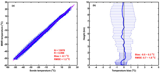
Figure 4.
(a) Scatter plot and (b) deviation profile between MWR and GPS radiosonde temperatures under a cloudy sky from June to July in 2018–2019 in Jiulong [32]. Here, the height of the vertical axis in (b) is above the ground.
3. Reducing Precipitation Impact on MWR Retrieval Accuracy by Off-Zenith Method
MWR retrieval accuracy usually decays under precipitation, especially when heavy precipitation occurs. To explore a solution to this issue, the off-zenith (15° elevation) observation of MWR is adopted by the Radiometrics Corporation to retrieve thermodynamic and liquid profiles [33]. When comparing MWR retrievals in the zenith method, MWR retrievals in the off-zenith method provide higher accuracy during precipitation because the influence of liquid water and ice on the MWR radome is minimized in the off-zenith method [10,11,34]. To further quantitatively evaluate the effect of the off-zenith method on reducing the impact of precipitation on MWR retrieval accuracy, Xu et al. (2014) [22] adopted the zenith and off-zenith methods simultaneously in MWR retrieval for comparison from May to September 2013 in Wuhan. It is found that under precipitation, MWR temperature bias (RMSE) against radiosondes decreases from 3.6 K (4.2 K) in the zenith method to 1.3 K (3.1 K) in the off-zenith method, and MWR vapor density bias (RMSE) also decreases from 1.10 g/m3 (2.90 g/m3) in the zenith method to 0.18 g/m3 (1.91 g/m3) in the off-zenith method (Table 4). However, the off-zenith method does not work well for MWR relative humidity. Compared to those in the zenith method, the bias and RMSE of MWR relative humidity against radiosondes under precipitation sky become greater in the off-zenith method but not smaller. As mentioned above, this may be related to the fact that relative humidity is artificially limited to less than 100% in radiosondes and MWR retrievals. Under a precipitation sky, the zenith brightness temperature is pseudo high due to the impact of precipitation, resulting in the MWR-retrieved relative humidity being more prone to saturation or even oversaturation; however, the pseudo high brightness temperature is not significant in the off-zenith method as the impact of precipitation is weakened, thus the MWR-retrieved relative humidity is not easily saturated as in the zenith method, which may benefit the agreement of relative humidity between MWR and radiosonde in the zenith method during saturated conditions. The comparison between MWR and radiosonde at each profile height shows MWR temperature and vapor density in the off-zenith method agree better with radiosondes at most profile heights than those in the zenith method, while the deviations against radiosondes are also smaller in the off-zenith method. Therefore, it can be concluded that the off-zenith method generally reduces the impact of precipitation on MWR retrieval accuracy because raindrops are not easily adhered to the radome sides due to gravity, and the off-zenith observation is more representative of the condition in which radiosonde sounding is taken [22].

Table 4.
Comparative results between radiosondes and MWR retrievals in the zenith and off-zenith methods for all profile heights under precipitation from May to September 2013 in Wuhan [22].
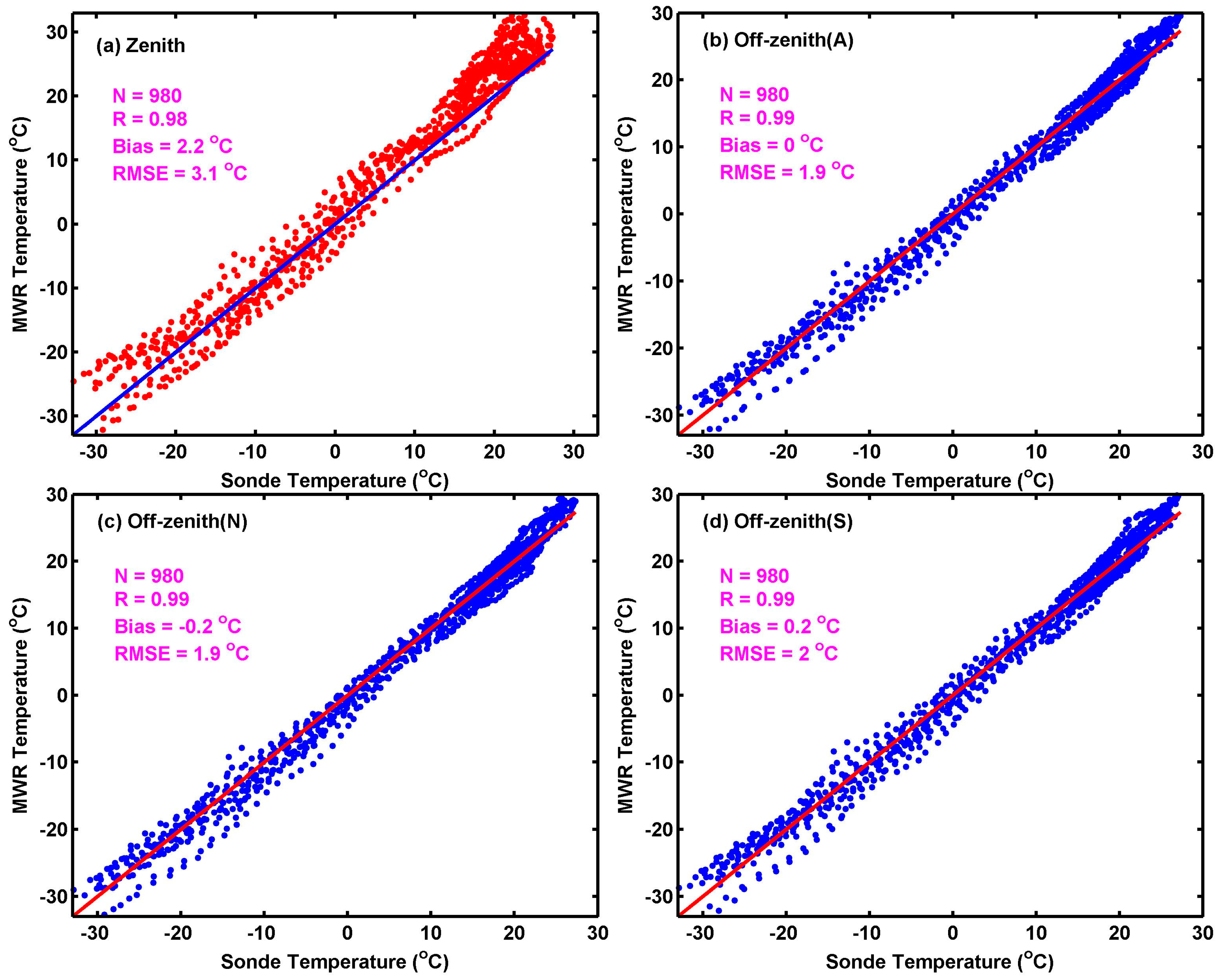
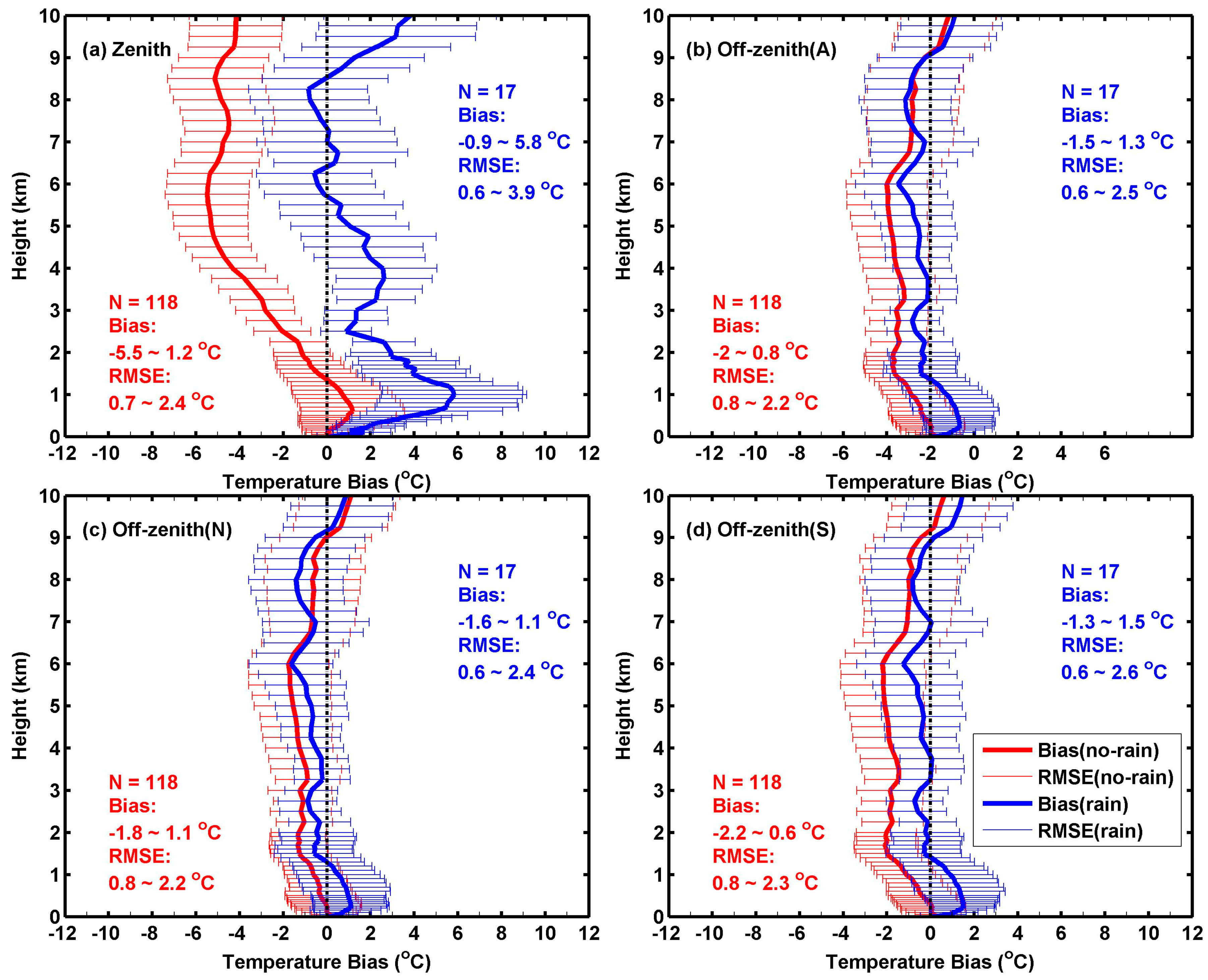
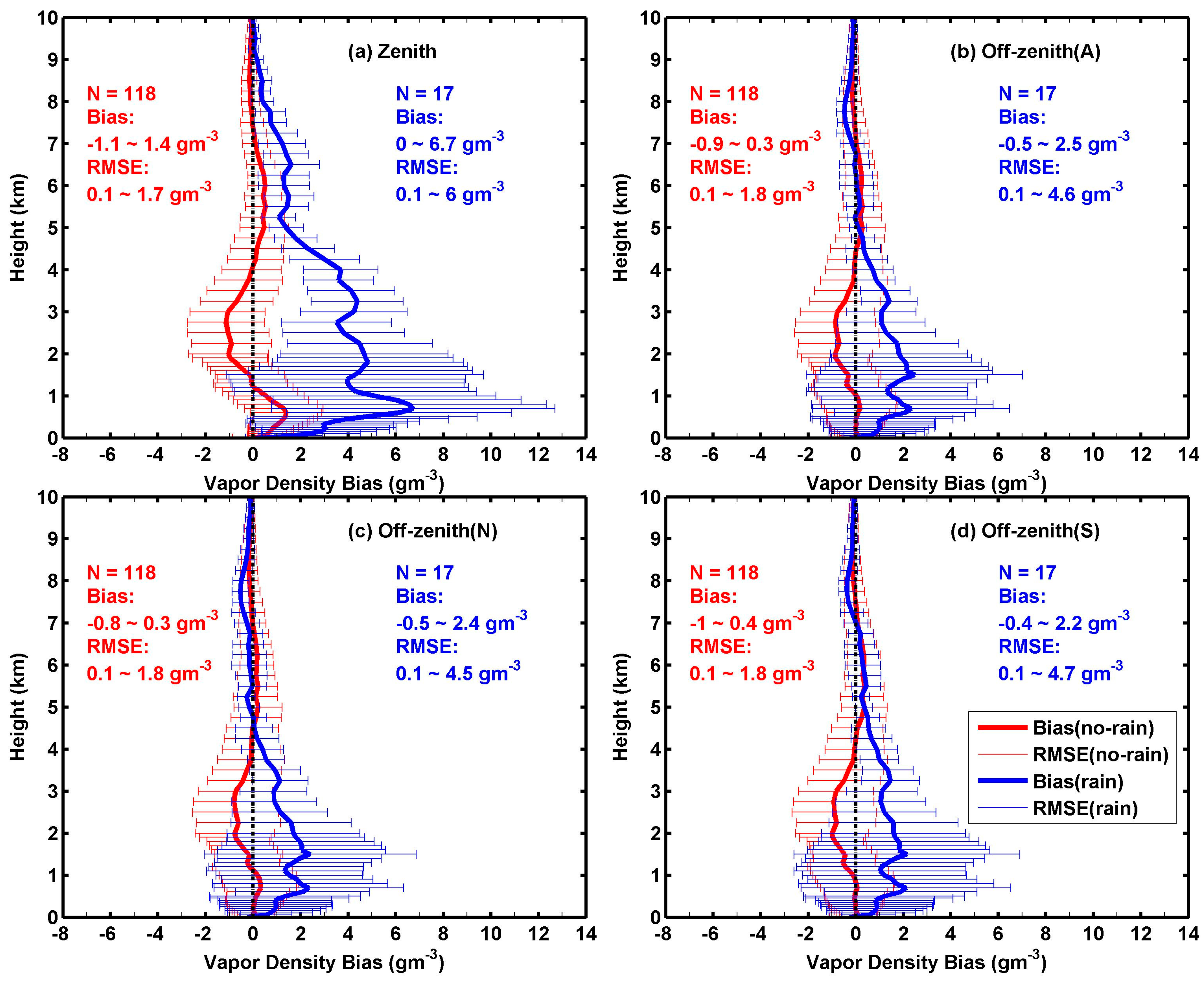
To explore whether there is a difference in the off-zenith method from different directions, the MWR in Wuhan was operated with the off-zenith method in the north and south directions as well as with the zenith method from June to August of 2017. It is found that under precipitation sky, the difference in off-zenith method from different directions is insignificant. The results in Figure 5 show that both MWR off-zenith temperatures in north and south directions present better accuracy against radiosondes than that in the zenith method, and the off-zenith discrepancy between north and south directions is small. Slight improvement seems to exist in MWR off-zenith temperature averaged from north and south directions, and this treatment is usually adopted in MWR off-zenith retrieval. Error profiles of MWR temperature against radiosondes under precipitation sky show that the off-zenith method has a smaller bias and RMSE than the zenith method at most profile heights (Figure 6). Moreover, MWR temperature accuracy under a non-precipitation sky is generally improved by the off-zenith method, which is also found in the study of Xu et al. (2014) [22]. Vapor density comparison between MWR with various methods and radiosonde presents a similar result to that for temperature (Figure 7). Obviously, this experiment confirms that regardless of the off-zenith method in the north or south direction, it can reduce the impact of precipitation on MWR retrieval accuracy.

Figure 5.
Scatter plots between radiosonde temperature and MWR temperatures in zenith and off-zenith methods under precipitation sky from June to August 2017 in Wuhan. (a) Zenith, (b) off-zenith averaged from north and south directions, (c) off-zenith in north direction, and (d) off-zenith in south direction.
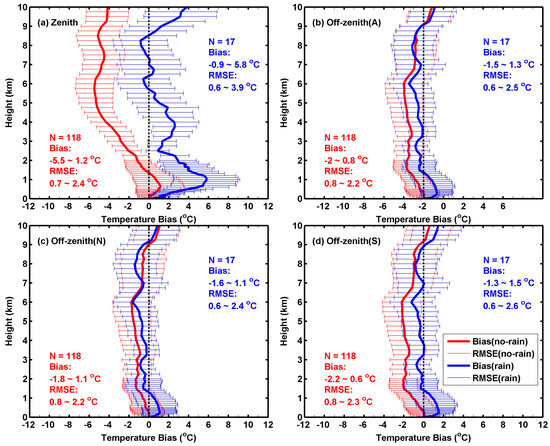
Figure 6.
Error profiles of MWR temperatures in various methods against radiosondes under precipitation sky from June to August 2017 in Wuhan. (a) Zenith, (b) off-zenith averaged from north and south directions, (c) off-zenith in north direction, and (d) off-zenith in south direction.
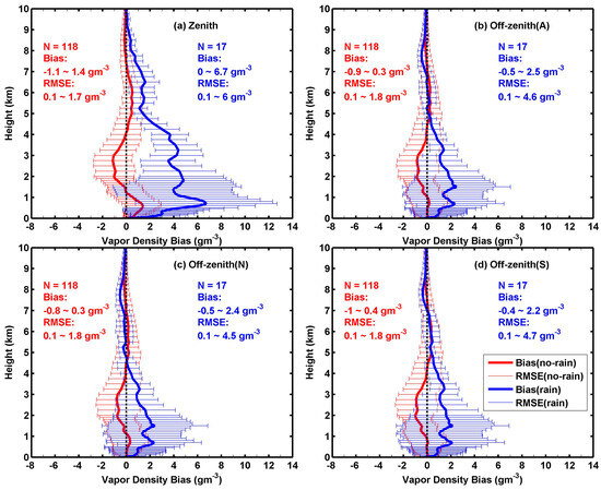
Figure 7.
Error profiles of MWR vapor density in various methods against radiosondes under precipitation sky from June to August 2017 in Wuhan. (a) Zenith, (b) off-zenith averaged from north and south directions, (c) off-zenith in north direction, and (d) off-zenith in south direction.
The off-zenith method can also reduce the impact of snow on MWR retrieval accuracy. According to a case study under a rainy and snowy sky in Wuhan, the signal saturation phenomenon of brightness temperature at K and V bands in the zenith method can be effectively eliminated in the off-zenith method [35]. Moreover, Zhang et al. (2017) [36] compared MWR retrievals in zenith and off-zenith methods with radiosondes during three snow cases in 2014 in Wuhan. The results show that MWR retrievals in the off-zenith method obviously agree better with radiosondes than those in the zenith method (Table 5). For MWR temperature, the bias of 0.1 K in the off-zenith method is significantly smaller than that of 5.2 K in the zenith method, and the RMSE also decreases from 5.4 K to 2.0 K. It is the same situation for MWR vapor density; the bias decreases from 1.51 g/m3 in the zenith method to 0.17 g/m3 in the off-zenith method, with the corresponding RMSE decreasing from 2.04 g/m3 to 0.63 g/m3. And the accuracy of MWR relative humidity is also improved by the off-zenith method. Moreover, the comparison between MWR retrievals and radiosondes at each profile height shows that at most profile heights, the MWR retrieval accuracy is improved in the off-zenith method compared to that in the zenith method. Therefore, according to the studies of [22,35,36], the off-zenith method can improve MWR retrieval accuracy under precipitation and snowy skies in central China.

Table 5.
Comparative results between radiosondes and MWR retrievals in zenith and off-zenith methods for all profile heights during three snow cases from 2014 in Wuhan [36].
4. Application of MWR Retrievals in Severe Weather
MWR is a robust and unattended instrument and can continuously provide atmospheric profiles at minute-level temporal resolution under nearly all weather conditions; therefore, it is useful in support of nowcasting and short-range weather forecasting [1]. Although MWR mainly operates in the zenith observation method and its retrieval accuracy decays under precipitation and snowy skies, it still provides a reasonable way to detect the evolution of atmospheric thermal structure in severe weather due to its high temporal and vertical resolutions, especially when combined with other instruments. Additionally, as shown in Table 6, some forecast indices, such as the K index, the TT (total totals) index, and the A index, can also be calculated from MWR retrievals. The K index introduced by George (1960) [37] can reflect the stability of atmospheric stratification; a higher K index indicates a higher probability of thunderstorms; and empirical thresholds of the K index are generally used to separate weak, moderate, and strong thunderstorm potential [1]. The TT index, introduced by Miller (1972) [38], is commonly used as a severe weather indicator; the larger the TT index, the more likely convective weather is to occur. A TT lower than 45 °C generally indicates weak thunderstorm potential, while a TT larger than 55 °C indicates a high possibility of severe thunderstorms [1]. The A index is a physical quantity that comprehensively considers the atmospheric thermal stability and saturation degree of water vapor. The larger the A index, the more unstable the atmosphere or the higher the saturation level of the lower and middle troposphere, which is more conducive to generating convective precipitation [39,40]. These forecast indices can enhance the application of MWR retrievals in severe weather research.

Table 6.
Definition and physical explanation of K index, A index, and TT index [1,40].
Using MWR observation from June 2008 to August 2012 in Xianning, Huang et al. (2013) [41] analyzed the characteristics of MWR retrievals before the occurrence of short-term rainstorms and other general rainfalls. The results indicate that rapid increasing in LWP and IWV is found within 12 h before short-term rainstorm occurrence; moreover, there exists temperature inversion near 800–950 hPa, while the largest K index and TT index are above 35 °C and 40 °C, respectively, within 6 h before short-term rainstorm occurrence; and the relative humidity in 0–6 km heights is saturating in 3 h before rainfall occurrence. With these signals, the probability of a short-term rainstorm occurrence is high in the coming 3 or 6 h. Based on hourly precipitation and MWR observation in 2012 in Wuhan, Wang et al. (2016) [42] explored the differences in MWR retrievals for rainfall events with different precipitation intensities. It is found that a significant increase in relative humidity in the atmosphere, especially in low atmospheres, is necessary for rainfall occurrence. The incremental center of vapor density below 2 km precedes the incremental center of LWC by 0.5–1 h. At 1.5–1 h before rainfall occurrence, the growth rates of vapor density and LWC increase rapidly. For heavy rainfall, relative humidity is saturated at 7 h in advance, while CBH decreases rapidly. When heavy rainfall is coming, the increase in LWP is significant, and vapor density and LWC have their maximum values in the low atmosphere. However, before weak rainfall occurrence, the increases in relative humidity, vapor density, and LWC in low atmosphere occur earlier and are stable, with weak incremental centers at a relatively high height. In addition, with a combined dataset of MWR, cloud radar, micro rain radar, ceilometer, and rain gauge, Zhang et al. (2020) [43] investigated the cloud LWC (CLWC) and rain LWC (RLWC) in various stages of monsoon precipitation in 2018 in Xianning. The CLWC profiles of MWR and the RLWC profiles of micro-rain radar during various stages of the precipitation case are temporally averaged, respectively, to analyze the vertical distributions of CLWC and RLWC. The results show that CLWC generally decreases with height before precipitation occurrence, and during the precipitation increasing period, CLWC first decreases with height below 0.9 km and then increases to 3.5 km before decreasing again. Above 1.0 km, CLWC presents a similar vertical structure during the precipitation increasing and decreasing periods, but the latter with small values. For RLWC, it varies with height, like CLWC below 3 km during the precipitation-increasing period, i.e., RLWC first decreases and then increases with height. However, RLWC decreases slowly with height during the precipitation decreasing period, and the value of RLWC is smaller compared to that in the precipitation increasing period. It is also found that deeper cloud thickness can easily lead to a larger CLWC, while a larger CLWC can easily result in a larger RLWC, which in turn causes a greater rain rate. This qualitatively explains the relationships among cloud thickness, CLWC, RLWC, and rain rate during monsoon precipitation.
MWR can also be applied to studying hail events. With observations of MWR and weather radar, Tang et al. (2012) [44] analyzed a hailstorm event on 12 April 2010 in Xianning. A multi-peak structure is found in the variations of IWV and LWP during the hailstorm event due to the strong updraft in the hail cloud, and the CBH fluctuates violently. The K index calculated from MWR retrievals shows a good indication of the hailstorm event. If taking the K index above 38 °C as an early warning indicator of the hailstorm event, early warning can be issued 45 min ahead of the first convective cell of the hailstorm event, and early warning can also be issued 20 min, 40 min, and 42 min ahead of the second, third, and fourth convective cells of the hailstorm event, respectively. Huang et al. (2014) [45] also analyzed two hailstorm cases that happened in Xianning on 26 February 2009 and 12 April 2010 with MWR observation. It is found that low-level warm air transportation and mid-level dry cold air intrusion result in the “upper dry and lower wet” vertical structure of relative humidity. The sensible heat and latent heat transported by the updraft from low levels cause significant warming at 2–3 km layers, and then the 0 °C, −5 °C, and −20 °C layers are slightly raised. Due to the rise of low-level moisture, IWV and LWP, as well as super-cooled liquid water, increased rapidly before hail occurrence. After the hail, IWV and LWP, including LWC below 0 °C, decrease because part of them becomes hail or precipitation during the hail event. Based on observations of wind profile radar and MWR, the hailstorm event on 12 April 2010 in Xianning was further studied by Huang et al. (2015) [46]. At 0.5 h prior to hail occurrence, the fluctuation of vertical velocity increases with height at 0–4 km layers. There exists deep wind shear at 0–6 km layers, with the maximum appearing about 1.5 h prior to hail occurrence. Besides the “upper dry and lower wet” vertical structure, the K index exceeds 35 °C, about 6 h ahead of hail. When IWV and LWP grow rapidly and reach their peaks, the hail is initiated. These studies demonstrate the potential of MWR for hail monitoring and early warning.
Furthermore, MWR retrievals can be used to study thunderstorm activity. Gou et al. (2018) [40] carried out application analysis of MWR retrievals in lightning potential predictability at Wuhan and Jingzhou. It is found that the K index, temperature difference between 850 hPa and 500 hPa, and A index present good correlation with the lightning when their values are above 35 °C, 25 °C, and 12 °C, respectively. The lightning potential predictability calculated by the instability index with thresholds obtained from MWR retrievals is improved to some extent. Based on the observations of Doppler radar and three MWRs at Wuhan, Xianning, and Jingzhou, Sun et al. (2019) [47] analyzed the characteristics of lightning and precipitation in three different severe convective events in central China. The results show that the differences in cloud-ground lightning (CG) flashes and precipitation are related to the LWC structure and the LWC peak height, and the collision of ice particles makes it hard to generate electricity under high LWC conditions. Also, the differences in convective available potential energy (CAPE), precipitation, and CG flashes are caused by a sudden increase in vapor density at 1.5–3 km heights. Moreover, the production of CG flashes is sensitive to the surface relative humidity, and when the relative humidity increases, the total number of CG flashes also increases. Additionally, Gou et al. (2020) [48] conducted an analysis of lightning and precipitation in three elevated convective events with observations of Doppler radar and MWR in Wuhan. The results indicate that the variation characteristics of the instability index calculated from MWR retrievals have important meaning for monitoring and early warning of elevated thunderstorms in the cold season. When the A index, TT index, K index, and temperature difference between 850 hPa and 500 hPa change rapidly, it can be judged that there will be thunderstorms. While the fluctuation curve begins to decline and become stable, it means that thunderstorms will weaken and disappear. Obviously, MWR provides a way to study atmospheric fine structure and its evolution in thunderstorms.
5. Remote Sensing of Cloud Property by MWR
MWR has been proven to be an accurate method for remote sensing LWP [15,16,17]. Especially, MWR features an IRT to detect cloud base temperature, and CBH can be inferred by using the contemporaneous MWR-retrieved temperature profile [3]. As MWR can automatically operate in all-weather conditions and provides observations at minute-level temporal intervals, it is a favorable instrument for the detection of long-term and continuous CBH as well as LWC and LWP at fixed points.
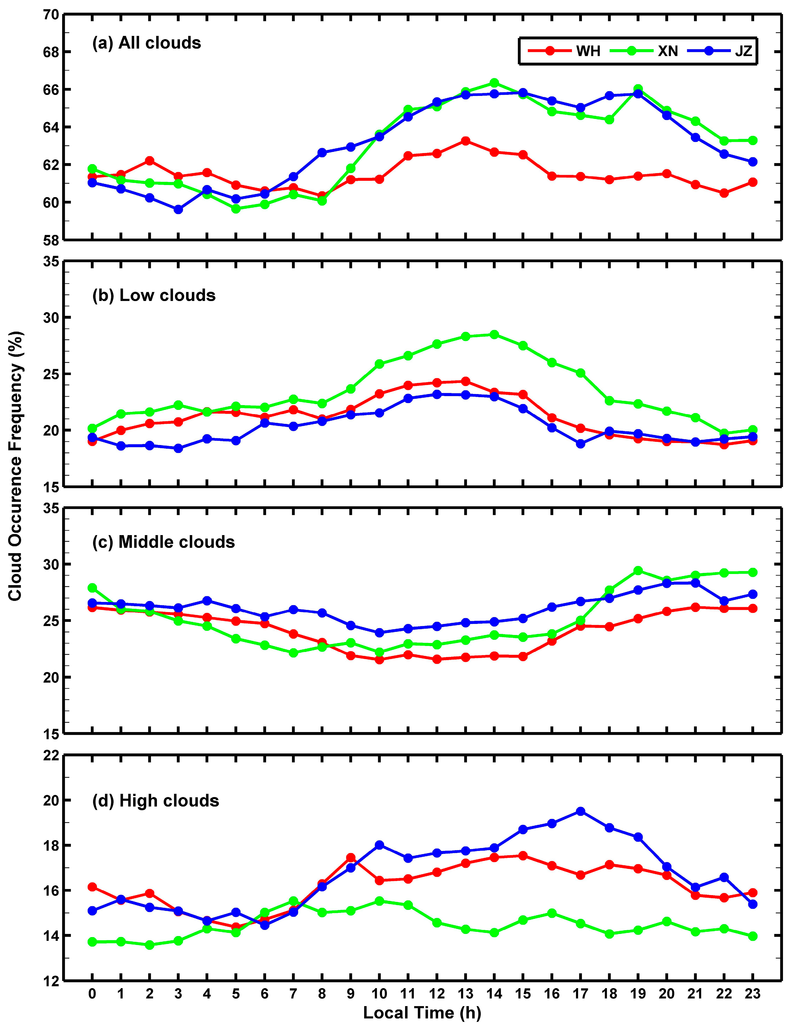
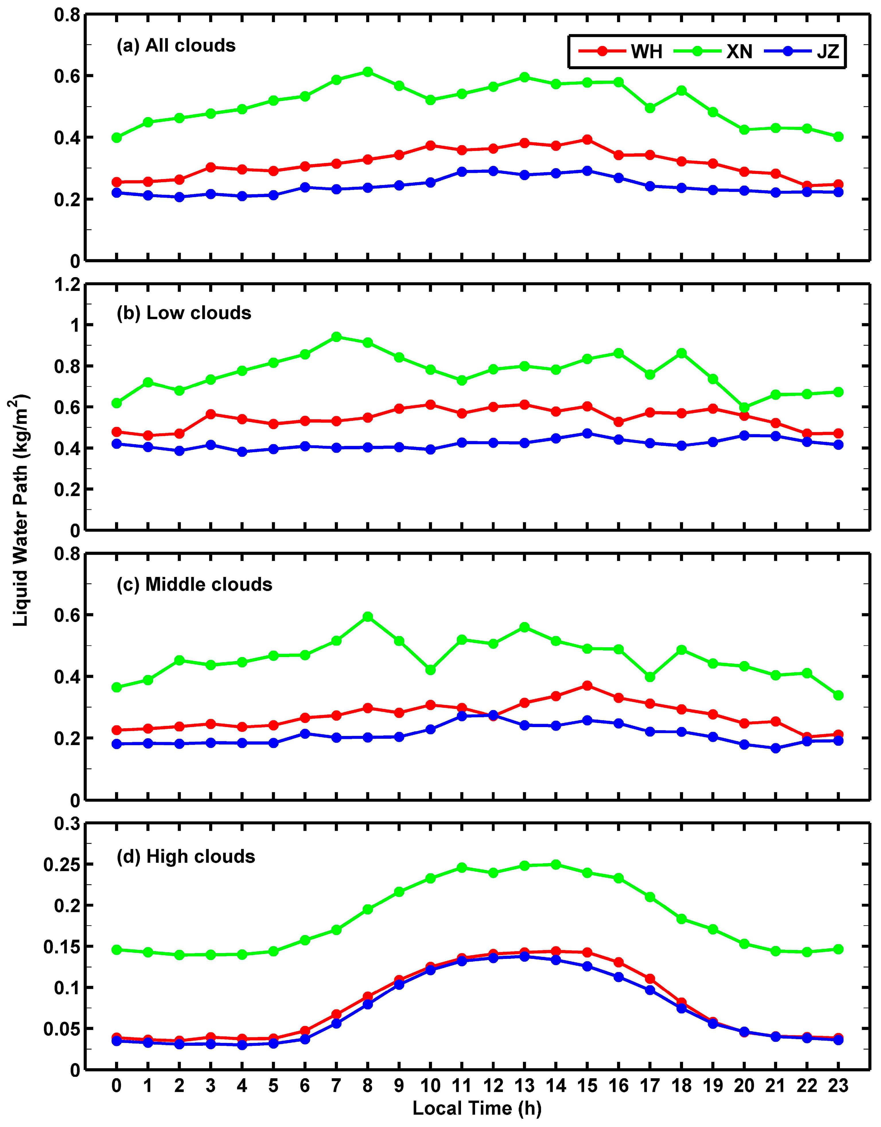
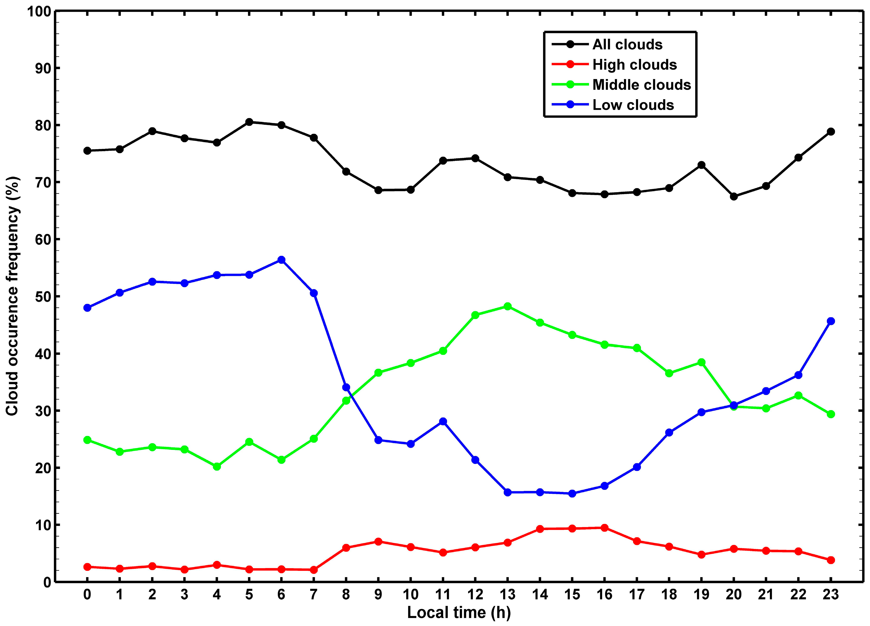
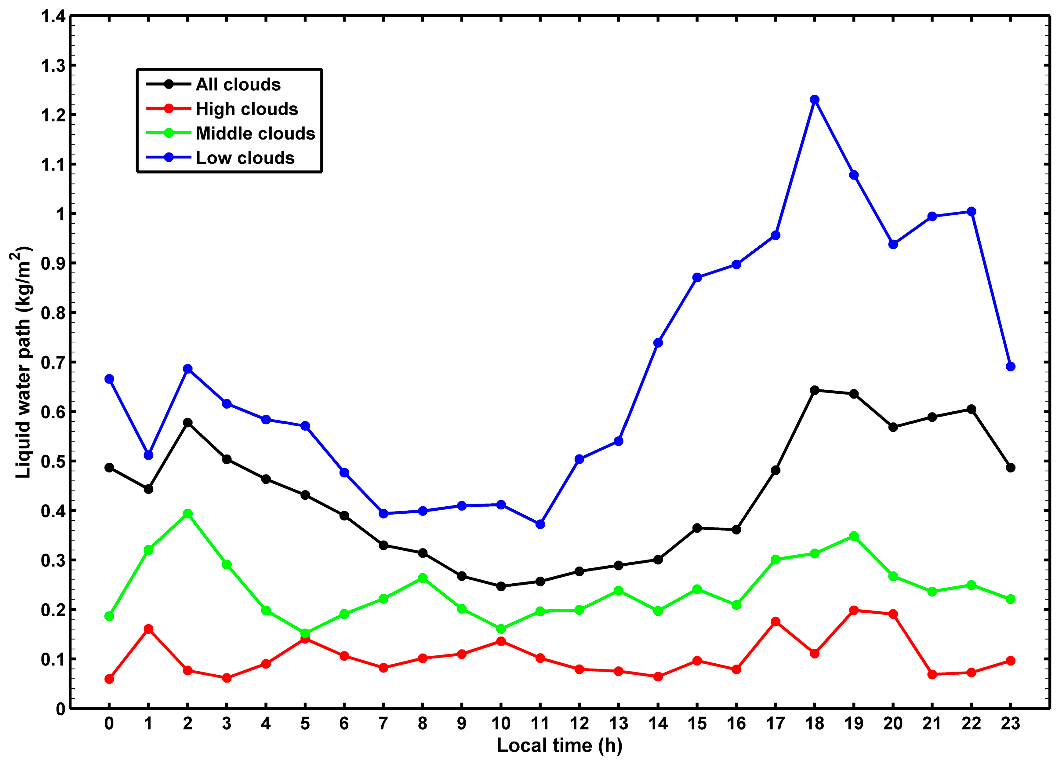
Using the 6-year data of MWR-retrieved CBH and LWP at Wuhan, Xianning, and Jingzhou, Xu et al. (2021) [49] investigated the temporal variations of cloud occurrence frequency (COF) and LWP for non-precipitating clouds in central China and also explored the vertical structure of COF. The COF is the ratio of the sample number of cloudy skies to the sample number of all skies, and the study of Xu et al. (2021) [49] just focuses on the lowest-level cloud because the IRT cannot penetrate clouds. The results indicate that there is a difference in the annual variation pattern of COF for different types of clouds; the COF is high in summer and low in winter for middle and high clouds, but the seasonal variation of COF for low clouds is insignificant. Comparable COFs are found for low, middle, and high clouds in the warm season, but the COF for high clouds in the cold season is lower than that for low and middle clouds, and the latter two still have comparable COFs. Moreover, there are also differences in the diurnal variation pattern of COF for different types of clouds (Figure 8). The COFs of low and high clouds are high during the day and low at night, but the COF of middle clouds is in the opposite direction. And the total COF presents a similar diurnal variation to that for low and high clouds. LWP over central China presents a quasi-bimodal pattern in its annual variation, with one peak occurring in April or June and another peak in September or October, and it is more obvious for LWP over middle clouds. A similar pattern is found in the diurnal variation of LWP for low, middle, and high clouds, in which LWP is relatively high in daytime and low in nighttime, and this pattern is significant for high clouds, showing a strong response to the diurnal variation of solar radiation (Figure 9). Additionally, the vertical distribution of COF presents a bimodal pattern in spring, summer, and winter, but it tends to be a unimodal pattern in autumn because the peak at high height weakens significantly. No matter how the vertical distribution of COF varies, there is a peak of COF always occurring at ~2.5 km height. Wang and Rossow (1995) [50] also found a lower peak in the vertical distribution of COF from upper-air observation at an ocean station with close latitude to central China, but at a lower height of ~1.5 km, showing the regional difference in the vertical distribution of COF.
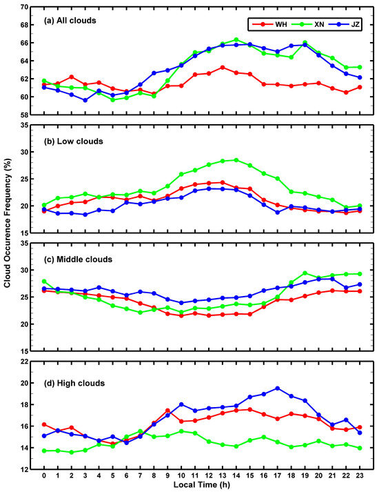
Figure 8.
Mean diurnal variations of COF for (a) all non-precipitating clouds, (b) low clouds, (c) middle clouds, and (d) high clouds at Wuhan (WH), Xianning (XN), and Jingzhou (JZ) from June 2010 to May 2016 [49].
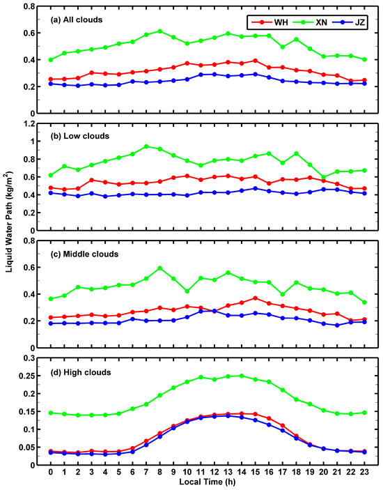
Figure 9.
Mean diurnal variations of LWP for (a) all non-precipitating clouds, (b) low clouds, (c) middle clouds, and (d) high clouds at Wuhan (WH), Xianning (XN), and Jingzhou (JZ) from June 2010 to May 2016 [49].
For comparison, Xu et al. (2023) [32] also analyzed the cloud properties of non-precipitating clouds observed by MWR at Jiulong in the eastern Tibetan Plateau from June to August in 2018–2019. It is interesting that the COFs of low and middle clouds at Jiulong present opposite diurnal variations to those over central China. As shown in Figure 10, the COF of low clouds at Jiulong is low in daytime and high in nighttime, while it is opposite for the COF of middle clouds, and both of them are respectively in the opposite direction to that over central China (Figure 8). Moreover, the COF at Jiulong presents a unimodal pattern in its vertical distribution, with the peak occurring at ~2 km height, and this is similar to the result of the lowest-level clouds observed by millimeter-wavelength cloud radar at Jiulong [51]. However, the COF over central China shows a bimodal pattern in its vertical distribution [49], different from the unimodal pattern of the COF at Jiulong. Furthermore, the LWP of low clouds observed by MWR at Jiulong is low in daytime and high in nighttime (Figure 11), which is similar to the diurnal variation of COF for low clouds but different from that over central China. Also, the diurnal variation of LWP of high clouds at Jiulong is insignificant, not showing an obvious response to the diurnal variation of solar radiation like that over central China [49], because the COF of high clouds at Jiulong is far lower than that over central China. According to the studies of Xu et al. (2021, 2023) [32,49], the summer monthly average COF for non-precipitating clouds at Jiulong (67–82%) is lower than that over central China (83–95%), with COF of low clouds (28–43%) much higher than that over central China (13–28%) but COF of high clouds (5–6%) much lower than that over central China (21–43%). These results show there are differences in cloud properties between the eastern Tibetan Plateau and central China, and this is related to the different characteristics of atmospheric water vapor between these two regions [52].
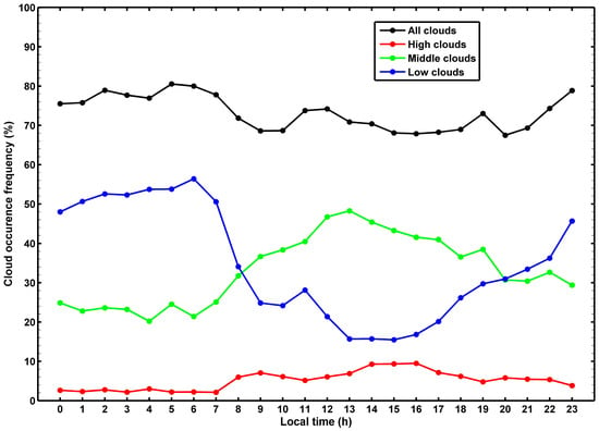
Figure 10.
Mean diurnal variation of COF for non-precipitating clouds from June to August in 2018–2019 at Jiulong [32].
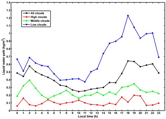
Figure 11.
Mean diurnal variation of LWP for non-precipitating clouds from June to August in 2018–2019 at Jiulong [32].
Although the resolution of the MWR-retrieved LWC profile is limited due to the relative insensitivity of MWR to vertical liquid water distribution [3,11,53], Zhang et al. (2020) [43] conducted an attempt to analyze the vertical distribution of LWC in clouds by MWR observation at Xianning during the monsoon of 2018. It is found that the mean LWC in non-precipitating clouds generally increases first with height and then decreases after reaching a peak of 0.08 g/m3, and this pattern is similar to the results obtained from cloud model statistics and observations of lidar and cloud radar [54,55]. Additionally, the study of Zhang et al. (2020) [43] also indicates that in precipitating clouds with a rain rate below 12 mm/h, the vertical distribution of LWC is similar to that for non-precipitating clouds, but the peak of 0.43 g/m3 is greater than the value of 0.08 g/m3 in non-precipitating clouds. This is because precipitation with a rain rate below 12 mm/h is not strong and mostly comes from nimbostratus. In such conditions, few cloud droplets collide due to the weak convective motion; therefore, the size and distribution of cloud droplets tend to be relatively uniform, which leads to stable LWC in clouds. To confirm these phenomena, Zhang et al. (2020) [43] also retrieved LWC profiles from the observation of cloud radar at Xianning. The results show that the vertical distribution of LWC obtained from cloud radar is similar to that from MWR for both non-precipitating and precipitating clouds. Nevertheless, the LWC of cloud radar presents a larger value than that of MWR. This is because cloud radar is more sensitive to small rain drops than MWR. The study of Zhang et al. (2020) [43] demonstrates the potential of MWR-retrieved LWC profiles in research on cloud structure.
6. Summary and Outlook
Comparative results in central China show that MWR temperature presents better consistency with radiosondes than MWR vapor density and relative humidity, and MWR retrieval accuracy is better at lower levels and also better under a cloudy sky than a clear sky. MWR retrieval accuracy usually decays under precipitation skies due to the effect of raindrops not included in the MWR retrieval principle. The off-zenith observation method is proven to be a way to reduce the impact of precipitation and snow on MWR retrieval accuracy and also shows improvement on MWR retrieval accuracy under a non-precipitation sky. Probably due to the limitation of sample size, the improvement of MWR retrieval accuracy under different precipitation intensities by the off-zenith method is rarely reported, and this work is worth exploring in the future with a reasonable sample size. Compared to central China, MWR can infer valid retrievals over the eastern Tibetan Plateau under both non-precipitation and precipitation skies because of the weak precipitation over there.
Application of MWR retrievals in central China demonstrates that the evolution of atmospheric thermal structure in severe weather can be detected, especially the “upper dry and lower wet” vertical structure in hailstorms, which is evident in MWR observation. The K index, A index, and TT index can be calculated from MWR retrievals, and these indexes as well as MWR-retrieved IWV and LWP are helpful for early warning on rainstorms, hailstorms, and thunderstorms.
MWR retrievals are also applied to study cloud properties, especially for non-precipitation clouds. In central China, the COF is high in summer and low in winter for middle and high clouds; it is also high in daytime and low in nighttime for low and high clouds but is opposite for middle clouds. Furthermore, the vertical distribution of COF presents a unimodal pattern in autumn and a bimodal one in other seasons, always with a peak at ~2.5 km height. LWP presents a quasi-bimodal pattern in its annual variation, and it is more significant for middle clouds. Although LWP presents similar diurnal variation for low, middle, and high clouds, the high LWP in daytime and low LWP in nighttime are more significant for high clouds, showing a strong response to the diurnal variation of solar radiation. Additionally, there are differences in cloud properties between the eastern Tibetan Plateau and central China.
However, even though the off-zenith method can reduce the precipitation impact on MWR retrieval accuracy, the decayed accuracy of MWR retrievals in the zenith method under precipitation sky remains a key issue to be resolved because most MWRs are currently operating in the zenith method. As a hydrophobic radome and forced airflow over the radome surface are helpful to obtain reasonably accurate MWR retrievals at a rainfall rate up to 10 mm/h [29], the improvement of radome waterproof performance and external blower efficiency is expected to help explore this issue. Since forecast indices derived from MWR retrievals are proven to be useful in support of nowcasting and short-range weather forecasting [1], and this review paper also shows the application of MWR retrievals in severe weather in central China, the improvement of MWR retrieval accuracy in the zenith method, especially under precipitation skies, will greatly promote the application of MWR retrievals in mechanism study and early warning of severe weather. Moreover, data assimilation of MWR retrievals shows a positive impact on accumulations and the distribution of precipitation in the early stage after forecast initialization [19,56]. And MWR-derived thermodynamic profiles present a larger impact than classical radiosonde observations in data denial experiments. Therefore, if MWR retrievals have comparable accuracy to radiosondes under all skies, data assimilation results can do better in taking advantage of MWR observation and bring more benefit for weather forecasting [2]. Furthermore, MWR cannot measure the clod top height but only the CBH of the lowest level cloud, and it is less sensitive to ice clouds than to liquid clouds [3,49]. Thus, to study multi-layer clouds or ice clouds, it is necessary to combine MWR with the instruments with better ability to detect these objects, such as millimeter-wavelength cloud radar, ceilometers, satellite-based radar, and so on.
Funding
This research was funded by the National Natural Science Foundation of China (Grant No. 42375139) and the Open Foundation of the Key Laboratory of Urban Meteorology, China Meteorological Administration (Grant No. LUM-2023-08).
Acknowledgments
The author is very grateful to the anonymous reviewers for their careful reading and comments that improved the flow and presentation of the manuscript.
Conflicts of Interest
The authors declare no conflicts of interest.
References
- Cimini, D.; Nelson, M.; Güldner, J.; Ware, R. Forecast indices from a ground-based microwave radiometer for operational meteorology. Atmos. Meas. Tech. 2015, 8, 315–333. [Google Scholar] [CrossRef]
- Illingworth, A.; Cimini, D.; Haefele, A.; Haeffelin, M.; Hervo, M.; Kotthaus, S.; Löhnert, U.; Martinet, P.; Mattis, I.; O’Connor, E.; et al. How can existing ground-based profiling instruments improve European weather forecast? Bull. Am. Meteorol. Soc. 2019, 100, 605–619. [Google Scholar] [CrossRef]
- Ware, R.; Carpenter, R.; Güldner, J.; Liljegren, J.; Nehrkorn, T.; Solheim, F.; Vandenberghe, F. A multi-channel radiometric profiler of temperature, humidity and cloud liquid. Radio Sci. 2003, 38, 8079. [Google Scholar] [CrossRef]
- Crewell, S.; Bloemink, H.; Feijt, A.; Garcia, S.G.; Jolivet, D.; Krasnov, O.A.; Van Lammeren, A.; Löhnert, U.; Van Meijgaard, E.; Meywerk, J.; et al. The BALTEX BRIDGE campaign: An integrated approach for a better understanding of clouds. Bull. Am. Meteorol. Soc. 2004, 85, 1565–1584. [Google Scholar] [CrossRef]
- Westwater, E.R.; Crewell, S.; Mätzler, C. A review of surfaced-based microwave and millimeter-wave radiometric remote sensing of the Troposphere. Radio Sci. Bull. 2004, 310, 59–80. [Google Scholar] [CrossRef]
- Löhnert, U.; Crewell, S.; Simmer, C. An integrated approach towards retrieving physically consistent profiles of temperature, humidity, and cloud liquid water. J. Appl. Meteorol. 2004, 43, 1295–1307. [Google Scholar] [CrossRef]
- Cimini, D.; Westwater, E.R.; Gasiewski, A.J. Temperature and humidity profiling in the Arctic using millimeter-wave radiometry and 1-DVAR. IEEE Trans. Geosci. Remote Sens. 2010, 48, 1381–1388. [Google Scholar] [CrossRef]
- Güldner, J.; Spȁnkuch, D. Remote sensing of the thermodynamic state of the atmospheric boundary layer by ground-based microwave radiometry. J. Atmos. Ocean. Technol. 2001, 18, 925–933. [Google Scholar] [CrossRef]
- Hewison, T. 1D-VAR retrievals of temperature and humidity profiles from a ground-based microwave radiometer. IEEE Trans. Geosci. Remote Sens. 2007, 45, 2163–2168. [Google Scholar] [CrossRef]
- Cimini, D.; Campos, E.; Ware, R.; Albers, S.; Giuliani, G.; Oreamuno, J.; Joe, P.; Koch, S.; Cober, S.; Westwater, E. Thermodynamic atmospheric profiling during the 2010 Winter Olympics using ground-based microwave radiometry. IEEE Trans. Geosci. Remote Sens. 2011, 49, 4959–4969. [Google Scholar] [CrossRef]
- Ware, R.; Cimini, D.; Campos, E.; Giuliani, G.; Albers, S.; Nelson, M.; Koch, S.E.; Joe, P.; Cober, S. Thermodynamic and liquid profiling during the 2010 Winter Olympics. Atmos. Res. 2013, 132–133, 278–290. [Google Scholar] [CrossRef]
- Knupp, K.; Ware, R.; Cimini, D.; Vandenberghe, F.; Vivekanandan, J.; Westwater, E.; Coleman, T. Ground-based passive microwave profiling during dynamic weather conditions. J. Atmos. Ocean. Technol. 2009, 26, 1057–1073. [Google Scholar] [CrossRef]
- Madhulatha, A.; Rajeevan, M.; Ratnam, M.V.; Bhate, J.; Naidu, C.V. Nowcasting severe convective activity over southeast India using ground-based microwave radiometer observations. J. Geophys. Res. Atmos. 2013, 118, 1–13. [Google Scholar] [CrossRef]
- Harikishan, G.; Padmakumari, B.; Maheskumar, R.S.; Pandithurai, G.; Min, Q.L. Macrophysical and microphysical properties of monsoon clouds over a rain shadow region in India from ground-based radiometric measurements. J. Geophys. Res. Atmos. 2014, 119, 4736–4749. [Google Scholar] [CrossRef]
- Westwater, E.R. The accuracy of water vapor and cloud liquid determination by dual-frequency ground-based microwave radiometry. Radio Sci. 1978, 13, 677–685. [Google Scholar] [CrossRef]
- Liljegren, J.C.; Clothiaux, E.E.; Mace, G.G.; Kato, S.; Dong, X. A new retrieval for cloud liquid water path using a groundbased microwave radiometer and measurements of cloud temperature. J. Geophys. Res. 2001, 106, 14485–14500. [Google Scholar] [CrossRef]
- Crewell, S.; Löhnert, U. Accuracy of cloud liquid water path from ground-based microwave radiometry 2. Sensor accuracy and synergy. Radio Sci. 2003, 38, 8042. [Google Scholar] [CrossRef]
- Cadeddu, M.P.; Liljegren, J.C.; Turner, D.D. The atmospheric radiation measurement (ARM) program network of microwave radiometers: Instrumentation, data, and retrievals. Atmos. Meas. Tech. 2013, 6, 2359–2372. [Google Scholar] [CrossRef]
- He, W.; Chen, H.; Li, J. Influence of assimilating ground-based microwave radiometer data into the WRF model on precipitation. Atmos. Ocean. Sci. 2020, 13, 107–112. [Google Scholar] [CrossRef]
- Cui, C.; Wan, R.; Wang, B.; Dong, X.; Li, H.; Wang, X.; Xu, G.; Wang, X.; Wang, Y.; Xiao, Y.; et al. The mesoscale heavy rainfall observing system (MHROS) over the middle region of the Yangtze River in China. J. Geophys. Res. Atmos. 2015, 120, 10399–10417. [Google Scholar] [CrossRef]
- Xu, G.; Zhang, W.; Wan, X.; Wang, B.; Leng, L.; Zhou, L.; Wan, R. Analysis on atmospheric profiles retrieved from microwave radiometer observation at Ganzi in the eastern Qinghai-Tibet Plateau. Torrential Rain Disasters 2019, 38, 238–248. (In Chinese) [Google Scholar] [CrossRef]
- Xu, G.; Ware, R.; Zhang, W.; Feng, G.; Liao, K.; Liu, Y. Effect of off-zenith observations on reducing the impact of precipitation on ground-based microwave radiometer measurement accuracy. Atmos. Res. 2014, 140–141, 85–94. [Google Scholar] [CrossRef]
- Decker, M.; Westwater, E.; Guiraud, F. Experimental evaluation of ground-based microwave sensing of atmospheric temperature and water vapor. J. Appl. Meteorol. 1978, 17, 1788–1795. [Google Scholar] [CrossRef]
- Xu, G.; Xi, B.; Zhang, W.; Cui, C.; Dong, X.; Liu, Y.; Yan, G. Comparison of atmospheric profiles between microwave radiometer retrievals and radiosonde soundings. J. Geophys. Res. Atmos. 2015, 120, 10313–10323. [Google Scholar] [CrossRef]
- Vömel, H.; Selkirk, H.; Miloshevich, L.; Valverde-Canossa, J.; Valdes, J.; Kyro, E.; Kivi, R.; Stolz, W.; Peng, G.; Diaz, Z. Radiation dry bias of the Vaisala RS92 humidity sensors. J. Atmos. Ocean. Technol. 2007, 24, 953–963. [Google Scholar] [CrossRef]
- Yoneyama, K.; Fujita, M.; Sato, N.; Fujiwara, M.; Inai, Y.; Hasebe, F. Correct for radiation dry bias found in RS92 radiosonde data during the MISMO field experiment. SOLA 2008, 4, 13–16. [Google Scholar] [CrossRef]
- Bian, J.; Chen, H.; Vömel, H.; Duan, Y.; Xuan, Y.; Lü, D. Intercomparison of humidity and temperature sensors: GTS1, Vaisala RS80, and CFH. Adv. Atmos. Sci. 2011, 28, 139–146. [Google Scholar] [CrossRef]
- Askne, J.I.; Westwater, E.R. A review of ground-based remote sensing of temperature and moisture by passive microwave radiometers. IEEE Trans. Geosci. Remote Sens. 1986, GE-24, 340–352. [Google Scholar] [CrossRef]
- Chan, P.W. Performance and application of a multi-wavelength, ground-based microwave radiometer in intense convective weather. Meteorol. Z. 2009, 18, 253–265. [Google Scholar] [CrossRef]
- Zhang, W.; Xu, G.; Yan, G.; Li, N.; Huang, Z.; Feng, G. Comparative analysis of microwave radiometer and radiosonde data. Meteorol. Sci. Technol. 2014, 42, 737–741. (In Chinese) [Google Scholar] [CrossRef]
- Zhang, W.; Xu, G.; Liao, K.; Yan, G.; Feng, G. Analysis on variation of ground-based microwave radiometer measurement accuracy. Torrential Rain Disasters 2017, 36, 373–381. (In Chinese) [Google Scholar] [CrossRef]
- Xu, G.; Wang, X.; Wan, R.; Li, P.; Li, Y.; Wang, J. Observational characteristics of summer non-precipitation clouds in Jiulong on the east side of the Qinghai-Tibet Plateau. Torrential Rain Disasters, 2023; in press. (In Chinese). [Google Scholar] [CrossRef]
- Solheim, F.; Godwin, J.; Westwater, E.; Han, Y.; Keihm, S.; Marsh, K.; Ware, R. Radiometric profiling of temperature, water vapor, and cloud liquid water using various inversion methods. Radio Sci. 1998, 33, 393–404. [Google Scholar] [CrossRef]
- Raju, S.; Renju, R.; Antony, T.; Mathew, N.; Moorthy, K. Microwave radiometric observation of a waterspout over coastal Arabian Sea. IEEE Geosci. Remote Sens. Lett. 2013, 10, 1075–1079. [Google Scholar] [CrossRef]
- Chen, Y.; Yang, F.; Xu, G.; Li, D.; Yuan, Z.; Xiong, J. Comparative analysis of the zenith and off-zenith retrieved results from microwaver radiometer in rain and snow weather conditions. Torrential Rain Disasters 2015, 34, 375–383. (In Chinese) [Google Scholar] [CrossRef]
- Zhang, W.; Xu, G.; Liu, Y.; Yan, G.; Li, D.; Wang, S. Uncertainties of ground-based microwave radiometer retrievals in zenith and off-zenith observations under snow conditions. Atmos. Meas. Tech. 2017, 10, 155–165. [Google Scholar] [CrossRef]
- George, J.J. Weather Forecasting for Aeronautics; Academic Press: New York, NY, USA, 1960; p. 673. [Google Scholar]
- Miller, R.C. Notes on Analysis and Severe Storm Forecasting Procedures of the Air Force Global Weather Central; Technical Report 200 (Rev.); Air Weather Service, United States Air Force: St. Claire, IL, USA, 1972; p. 190. [Google Scholar]
- Wang, J.; Liu, H.; Liu, W. Stratification conditions of severe convective weather on the Leizhou Peninsula in July and August 2007. Meteorol. Mon. 2008, 34, 262–265. (In Chinese) [Google Scholar] [CrossRef]
- Gou, A.; Han, F.; Zhang, W.; Liu, X.; Niu, B. An application analysis of the ground-based microwave radiometer observation in lightning potential predictability. J. Trop. Meteorol. 2018, 34, 268–278. (In Chinese) [Google Scholar] [CrossRef]
- Huang, Z.; Xu, G.; Wang, X.; Tang, Y. Applications of ground-based microwave radiation data to short-term rainstorm and potential forecast. J. Appl. Meteorol. Sci. 2013, 24, 576–584. (In Chinese) [Google Scholar]
- Wang, X.; Xu, G.; Yuan, K. Different characteristic analysis of inversion parameters for heavy rainfall and weak rainfall by microwave radiometer data. Torrential Rain Disasters 2016, 35, 227–233. (In Chinese) [Google Scholar] [CrossRef]
- Zhang, W.; Xu, G.; Xi, B.; Ren, J.; Wan, X.; Zhou, L.; Cui, C.; Wu, D. Comparative study of cloud liquid water and rain liquid water obtained from microwave radiometer and micro rain radar observations over central China during the Monsoon. J. Geophys. Res. Atmos. 2020, 125, e2020JD032456. [Google Scholar] [CrossRef]
- Tang, R.; Li, D.; Xiang, Y.; Xu, G.; Li, Y.; Chen, Y. Analysis of a hailstorm event in the middle Yangtze River basin using ground microwave radiometers. Acta Meteorol. Sin. 2012, 70, 806–813. (In Chinese) [Google Scholar] [CrossRef]
- Huang, Z.; Xu, G.; Wang, X.; Tang, Y. Analysis on two hailstorm events in Xianning based on observations of ground-based microwave radiometer. Meteorol. Mon. 2014, 40, 216–222. (In Chinese) [Google Scholar] [CrossRef]
- Huang, Z.; Zhou, Z.; Xu, G.; Zhang, W.; Wang, Y. Monitoring application of hailstorm event with the observation of wind profile radar and ground-based microwave radiometer. Plateau Meteorol. 2015, 34, 269–278. (In Chinese) [Google Scholar] [CrossRef]
- Sun, J.; Chai, J.; Leng, L.; Xu, G. Analysis of lightning and precipitation activities in three severe convective events based on Doppler radar and microwave radiometer over the central China region. Atmosphere 2019, 10, 298. [Google Scholar] [CrossRef]
- Gou, A.; Gao, Z.; Hou, J.; Han, F.; Liu, W.; Zhang, W.; Zhang, W. Analysis of lightning and precipitation activities in three elevated convective events based on Doppler radar and microwave radiometer in Hubei province. J. Trop. Meteorol. 2020, 36, 528–541. (In Chinese) [Google Scholar] [CrossRef]
- Xu, G.; Zhang, W.; Wan, X.; Wang, B. Cloud occurrence frequency and cloud liquid water path for non-precipitation clouds using ground-based measurements over central China. J. Atmos. Solar-Terr. Phys. 2021, 215, 105575. [Google Scholar] [CrossRef]
- Wang, J.; Rossow, B. Determination of cloud vertical structure from upper-air observations. J Appl. Meteorol. 1995, 34, 2243–2258. [Google Scholar] [CrossRef]
- Wan, X.; Zheng, J.; Wan, R.; Xu, G.; Qin, J.; Yi, L. Intercomparison of cloud vertical structures over four different sites of the eastern slope of the Tibetan Plateau in summer using Ka-band millimeter-wave radar measurements. Remote Sens. 2022, 14, 3702. [Google Scholar] [CrossRef]
- Xu, G.; Cui, C.; Li, W.; Zhang, W.; Feng, G. Variations of GPS precipitable water over the Qinghai-Tibet Plateau: Possible teleconnection triggering rainfall over the Yangtze river valley. Terr. Atmos. Ocean. Sci. 2011, 22, 195–202. [Google Scholar] [CrossRef]
- Crewell, S.; Ebell, K.; Löhnert, U.; Turner, D. Can liquid water profiles be retrieved from passive microwave zenith observations? Geophys. Res. Lett. 2009, 36, L06803. [Google Scholar] [CrossRef]
- Löhnert, U.; Crewell, S. Accuracy of cloud liquid water path from ground-based microwave radiometry 1. Dependency on cloud model statistics. Radio Sci. 2003, 38, 8041. [Google Scholar] [CrossRef]
- Sakai, T.; Whiteman, D.N.; Russo, F.; Turner, D.D.; Veselovskii, I.; Melfi, S.H.; Nagai, T.; Mano, Y. Liquid water cloud measurements using the Raman lidar technique: Current understanding and future research needs. J. Atmos. Ocean. Tech. 2013, 30, 1337–1353. [Google Scholar] [CrossRef]
- Caumont, O.; Cimini, D.; Löhnert, U.; Alados-Arboledas, L.; Bleisch, R.; Buffa, F.; Ferrario, M.E.; Haefele, A.; Huet, T.; Madonna, F.; et al. Assimilation of humidity and temperature observations retrieved from ground-based microwave radiometers into a convective-scale NWP model. Q. J. R. Meteorol. Soc. 2016, 142, 2692–2704. [Google Scholar] [CrossRef]
Disclaimer/Publisher’s Note: The statements, opinions and data contained in all publications are solely those of the individual author(s) and contributor(s) and not of MDPI and/or the editor(s). MDPI and/or the editor(s) disclaim responsibility for any injury to people or property resulting from any ideas, methods, instructions or products referred to in the content. |
© 2024 by the author. Licensee MDPI, Basel, Switzerland. This article is an open access article distributed under the terms and conditions of the Creative Commons Attribution (CC BY) license (https://creativecommons.org/licenses/by/4.0/).

