Intercomparison of Leaf Area Index Products Derived from Satellite Data over the Heihe River Basin
Abstract
1. Introduction
2. Study Area and Data
2.1. Study Area
2.2. Data
2.2.1. MCD15A2H
2.2.2. VNP15A2H
2.2.3. CLMS
2.2.4. GLASS
3. Method
3.1. Triple Collocation Method
3.2. Data Analysis
3.2.1. Triple Collocation Analysis Within Grid Cells
3.2.2. Triple Collocation Analysis for Each Pixel
4. Results
4.1. Direct Intercomparison of LAI Products over the Heihe River Basin
4.2. Absolute Uncertainties
4.3. Relative Uncertainties
5. Discussion
5.1. Performance of the Triple Collocation Method
5.2. Limitations and Future Prospects
6. Conclusions
Author Contributions
Funding
Data Availability Statement
Conflicts of Interest
Appendix A


References
- Chen, J.M.; Black, T.A. Defining Leaf Area Index for Non-Flat Leaves. Plant Cell Environ. 1992, 15, 421–429. [Google Scholar] [CrossRef]
- Al-Kaisi, M.; Brun, L.J.; Enz, J.W. Transpiration and Evapotranspiration from Maize as Related to Leaf Area Index. Agric. For. Meteorol. 1989, 48, 111–116. [Google Scholar] [CrossRef]
- Alton, P.B. Decadal Trends in Photosynthetic Capacity and Leaf Area Index Inferred from Satellite Remote Sensing for Global Vegetation Types. Agric. For. Meteorol. 2018, 250–251, 361–375. [Google Scholar] [CrossRef]
- Jarlan, L.; Balsamo, G.; Lafont, S.; Beljaars, A.; Calvet, J.C.; Mougin, E. Analysis of Leaf Area Index in the ECMWF Land Surface Model and Impact on Latent Heat and Carbon Fluxes: Application to West Africa. J. Geophys. Res. Atmos. 2008, 113, D24117. [Google Scholar] [CrossRef]
- Belward, A.; Bourassa, M.; Dowell, M.; Briggs, S.; Dolman, H.A.J.; Holmlund, K.; Husband, R.; Quegan, S.; Simmons, A.; Sloyan, B.; et al. The Global Observing System for Climate: Implementation Needs; World Meteorological Organization: Geneva, Switzerland, 2016. [Google Scholar]
- Hirofumi, H.; Wang, W.; Milesi, C.; White, M.A.; Ganguly, S.; Gamo, M.; Hirata, R.; Myneni, R.B.; Nemani, R.R. Exploring Simple Algorithms for Estimating Gross Primary Production in Forested Areas from Satellite Data. Remote Sens. 2012, 4, 303–326. [Google Scholar] [CrossRef]
- Ray, L.; Zhang, Y.Q.; Rajaud, A.; Cleugh, H.; Tu, K. A Simple Surface Conductance Model to Estimate Regional Evaporation Using MODIS Leaf Area Index and the Penman-Monteith Equation. Water Resour. Res. 2008, 44, W10419. [Google Scholar] [CrossRef]
- Donohue, R.J.; Roderick, M.L.; McVicar, T.R. On the Importance of Including Vegetation Dynamics in Budyko’s Hydrological Model. Hydrol. Earth Syst. Sci. 2007, 11, 983–995. [Google Scholar] [CrossRef]
- Fang, H.; Baret, F.; Plummer, S.; Schaepman-Strub, G. An Overview of Global Leaf Area Index (LAI): Methods, Products, Validation, and Applications. Rev. Geophys. 2019, 57, 739–799. [Google Scholar] [CrossRef]
- Fernandes, R.; Plummer, S.; Nightingale, J.; Baret, F.; Camacho, F.; Fang, H.; Garrigues, S.; Gobron, N.; Lang, M.; Lacaze, R.; et al. Global leaf area index product validation good practices, in Best practice for satellite-derived land product validation, 2.0. In Land Product Validation Subgroup; Fernandes, R., Plummer, S., Nightingale, J., Eds.; Committee on Earth Observation Satellites Working Group on Calibration and Validation: Greenbelt, MD, USA, 2014. [Google Scholar] [CrossRef]
- Li, X.; Ma, M.; Wang, J.; Liu, Q.; Che, T.; Hu, Z.; Xiao, Q.; Liu, Q. Simultaneous Remote Sensing and Ground-based Experiment in the Heihe River Basin: Scientific Objectives and Experiment Design. Adv. Earth Sci. 2008, 23, 897–914. [Google Scholar]
- Li, X.; Li, X.; Li, Z. Watershed Allied Telemetry Experimental Research (WATER) Datasets are Available for Open Access. Remote Sens. Technol. Appl. 2010, 25, 761–765. [Google Scholar] [CrossRef]
- Li, X.; Wang, S.G.; Ge, Y.; Jin, R.; Liu, S.M.; Ma, M.G.; Shi, W.Z.; Li, R.X.; Liu, Q.H. Development and Experimental Verification of Key Techniques to Validate Remote Sensing Products. ISPRS Int. Arch. Photogramm. Remote Sens. Spat. Inf. Sci. 2013, XL-2/W1, 25–30. [Google Scholar] [CrossRef]
- Zhang, Y.; Qu, Y.; Wang, J.; Liang, S.; Liu, Y. Estimating Leaf Area Index from MODIS and Surface Meteorological Data Using a Dynamic Bayesian Network. Remote Sens. Environ. 2012, 127, 30–43. [Google Scholar] [CrossRef]
- Chen, Y.P.; Wei, W.; Patterson, A.E.; Tong, L. Spatial Scale Conversion Approach for Moderate-Resolution Imaging Spectroradiometer Leaf Area Index Product Validation. J. Appl. Remote Sens. 2013, 7, 073463. [Google Scholar] [CrossRef]
- Qu, Y.; Han, W.; Ma, M. Retrieval of a Temporal High-Resolution Leaf Area Index (LAI) by Combining MODIS LAI and ASTER Reflectance Data. Remote Sens. 2015, 7, 195–210. [Google Scholar] [CrossRef]
- Shi, Y.; Wang, J.; Qin, J.; Qu, Y. An Upscaling Algorithm to Obtain the Representative Ground Truth of LAI Time Series in Heterogeneous Land Surface. Remote Sens. 2015, 7, 12887–12908. [Google Scholar] [CrossRef]
- Buermann, W.; Wang, Y.; Dong, J.; Zhou, L.; Zeng, X.; Dickinson, R.E.; Potter, C.S.; Myneni, R.B. Analysis of a Multiyear Global Vegetation Leaf Area Index Data Set. J. Geophys. Res. Atmos. 2002, 107, 14–16. [Google Scholar] [CrossRef]
- Kang, H.-S.; Xue, Y.; Collatz, G.J. Impact Assessment of Satellite-Derived Leaf Area Index Datasets Using a General Circulation Model. J. Clim. 2007, 20, 993–1015. [Google Scholar] [CrossRef]
- Camacho, F.; Cernicharo, J.; Lacaze, R.; Baret, F.; Weiss, M. GEOV1: LAI, FAPAR Essential Climate Variables and FCOVER Global Time Series Capitalizing over Existing Products. Part 2: Validation and Intercomparison with Reference Products. Remote Sens. Environ. 2013, 137, 310–329. [Google Scholar] [CrossRef]
- Jin, H.; Li, A.; Bian, J.; Nan, X.; Zhao, W.; Zhang, Z.; Yin, G. Intercomparison and Validation of MODIS and GLASS Leaf Area Index (LAI) Products over Mountain Areas: A Case Study in Southwestern China. Int. J. Appl. Earth Obs. Geoinf. 2017, 55, 52–67. [Google Scholar] [CrossRef]
- D’Odorico, P.; Gonsamo, A.; Pinty, B.; Gobron, N.; Coops, N.; Mendez, E.; Schaepman, M.E. Intercomparison of Fraction of Absorbed Photosynthetically Active Radiation Products Derived from Satellite Data over Europe. Remote Sens. Environ. 2014, 142, 141–154. [Google Scholar] [CrossRef]
- Xu, B.; Li, J.; Park, T.; Liu, Q.; Zeng, Y.; Yin, G.; Zhao, J.; Fan, W.; Yang, L.; Knyazikhin, Y.; et al. An Integrated Method for Validating Long-Term Leaf Area Index Products Using Global Networks of Site-Based Measurements. Remote Sens. Environ. 2018, 209, 134–151. [Google Scholar] [CrossRef]
- Croft, H.; Chen, J.M.; Zhang, Y. Temporal Disparity in Leaf Chlorophyll Content and Leaf Area Index across a Growing Season in a Temperate Deciduous Forest. Int. J. Appl. Earth Obs. Geoinf. 2014, 33, 312–320. [Google Scholar] [CrossRef]
- Zhu, Z.; Bi, J.; Pan, Y.; Ganguly, S.; Anav, A.; Xu, L.; Samanta, A.; Piao, S.; Nemani, R.R.; Myneni, R.B. Global Data Sets of Vegetation Leaf Area Index (LAI)3g and Fraction of Photosynthetically Active Radiation (FPAR)3g Derived from Global Inventory Modeling and Mapping Studies (GIMMS) Normalized Difference Vegetation Index (NDVI3g) for the Period 1981 to 2011. Remote Sens. 2013, 5, 927–948. [Google Scholar] [CrossRef]
- Anav, A.; Murray-Tortarolo, G.; Friedlingstein, P.; Sitch, S.; Piao, S.; Zhu, Z. Evaluation of Land Surface Models in Reproducing Satellite Derived Leaf Area Index over the High-Latitude Northern Hemisphere. Part II: Earth System Models. Remote Sens. 2013, 5, 3637–3661. [Google Scholar] [CrossRef]
- Fang, H.; Wei, S.; Jiang, C.; Scipal, K. Theoretical Uncertainty Analysis of Global MODIS, CYCLOPES, and GLOBCARBON LAI Products Using a Triple Collocation Method. Remote Sens. Environ. 2012, 124, 610–621. [Google Scholar] [CrossRef]
- García-Haro, F.J.; Campos-Taberner, M.; Muñoz-Marí, J.; Laparra, V.; Camacho, F.; Sánchez-Zapero, J.; Camps-Valls, G. Derivation of Global Vegetation Biophysical Parameters from EUMETSAT Polar System. ISPRS J. Photogramm. Remote Sens. 2018, 139, 57–74. [Google Scholar] [CrossRef]
- Xiao, Z.; Liang, S.; Wang, J.; Chen, P.; Yin, X.; Zhang, L.; Song, J. Use of General Regression Neural Networks for Generating the GLASS Leaf Area Index Product from Time-Series MODIS Surface Reflectance. IEEE Trans. Geosci. Remote Sens. 2014, 52, 209–223. [Google Scholar] [CrossRef]
- Frederic, B.; Hagolle, O.; Geiger, B.; Bicheron, P.; Miras, B.; Huc, M.; Berthelot, B.; Niño, F.; Weiss, M.; Samain, O.; et al. LAI, fAPAR and fCover CYCLOPES Global Products Derived from VEGETATION: Part 1: Principles of the Algorithm. Remote Sens. Environ. 2007, 110, 275–286. [Google Scholar] [CrossRef]
- Knyazikhin, Y.; Martonchik, J.V.; Diner, D.J.; Myneni, R.B.; Verstraete, M.; Pinty, B.; Gobron, N. Estimation of Vegetation Canopy Leaf Area Index and Fraction of Absorbed Photosynthetically Active Radiation from Atmosphere-Corrected MISR Data. J. Geophys. Res. Atmos. 1998, 103, 32239–32256. [Google Scholar] [CrossRef]
- Yan, K.; Park, T.; Chen, C.; Xu, B.; Song, W.; Yang, B.; Zeng, Y.; Liu, Z.; Yan, G. Generating Global Products of LAI and FPAR From SNPP-VIIRS Data: Theoretical Background and Implementation. IEEE Trans. Geosci. Remote Sens. 2018, 56, 2119–2137. [Google Scholar] [CrossRef]
- Pinty, B.; Andredakis, I.; Clerici, M.; Kaminski, T.; Taberner, M.; Verstraete, M.M.; Gobron, N.; Plummer, S.; Widlowski, J.-L. Exploiting the MODIS Albedos with the Two-Stream Inversion Package (JRC-TIP): 1. Effective Leaf Area Index, Vegetation, and Soil Properties. J. Geophys. Res. Atmos. 2011, 116, 1–20. [Google Scholar] [CrossRef]
- McColl, K.A.; Vogelzang, J.; Konings, A.G.; Entekhabi, D.; Piles, M.; Stoffelen, A. Extended Triple Collocation: Estimating Errors and Correlation Coefficients with Respect to an Unknown Target. Geophys. Res. Lett. 2014, 41, 6229–6236. [Google Scholar] [CrossRef]
- Ganguly, S.; Samanta, A.; Shabanov, N.; Cristina, M.; Nemani, R.; Knyazikhin, Y.; Myneni, R. Generating Vegetation Leaf Area Index Earth System Data Record from Multiple Sensors. Part 1: Theory. Remote Sens. Environ. 2008, 112, 4333–4343. [Google Scholar] [CrossRef]
- Yan, K.; Park, T.; Yan, G.; Liu, Z.; Yang, B.; Chen, C.; Nemani, R.R.; Knyazikhin, Y.; Myneni, R.B. Evaluation of MODIS LAI/FPAR Product Collection 6. Part 2: Validation and Intercomparison. Remote Sens. 2016, 8, 460. [Google Scholar] [CrossRef]
- Xu, B.; Park, T.; Yan, K.; Chen, C.; Zeng, Y.; Song, W.; Yin, G.; Li, J.; Liu, Q.; Knyazikhin, Y.; et al. Analysis of Global LAI/FPAR Products from VIIRS and MODIS Sensors for Spatio-Temporal Consistency and Uncertainty from 2012–2016. Forests 2018, 9, 73. [Google Scholar] [CrossRef]
- Zhang, X.; Liu, L.; Liu, Y.; Jayavelu, S.; Wang, J.; Moon, M.; Henebry, G.M.; Friedl, M.A.; Schaaf, C.B. Generation and Evaluation of the VIIRS Land Surface Phenology Product. Remote Sens. Environ. 2018, 216, 212–229. [Google Scholar] [CrossRef]
- Justice, C.O.; Román, M.O.; Csiszar, I.; Vermote, E.F.; Wolfe, R.E.; Hook, S.J.; Friedl, M.; Wang, Z.; Schaaf, C.B.; Miura, T.; et al. Land and Cryosphere Products from Suomi NPP VIIRS: Overview and Status. J. Geophys. Res. Atmos. 2013, 118, 9753–9765. [Google Scholar] [CrossRef]
- Fuster, B.; Sánchez-Zapero, J.; Camacho, F.; García-Santos, V.; Verger, A.; Lacaze, R.; Weiss, M.; Baret, F.; Smets, B. Quality Assessment of CLMS LAI, fAPAR and fCOVER Collection 300 m Products of Copernicus Global Land Service. Remote Sens. 2020, 12, 1017. [Google Scholar] [CrossRef]
- Ma, H.; Liang, S. Development of the GLASS 250-m Leaf Area Index Product (Version 6) from MODIS Data Using the Bidirectional LSTM Deep Learning Model. Remote Sens. Environ. 2022, 273, 112985. [Google Scholar] [CrossRef]
- Stoffelen, A. Toward the True Near-Surface Wind Speed: Error Modeling and Calibration Using Triple Collocation. J. Geophys. Res. Ocean. 1998, 103, 7755–7766. [Google Scholar] [CrossRef]
- Portabella, M.; Stoffelen, A. On Scatterometer Ocean Stress. J. Atmos. Ocean. Technol. 2009, 26, 368–382. [Google Scholar] [CrossRef]
- Vogelzang, J.; Stoffelen, A.; Verhoef, A.; Figa-Saldaña, J. On the Quality of High-Resolution Scatterometer Winds. J. Geophys. Res. Ocean. 2011, 116, 5565. [Google Scholar] [CrossRef]
- Caires, S.; Sterl, A. Validation of Ocean Wind and Wave Data Using Triple Collocation. J. Geophys. Res. Ocean. 2003, 108, 3098. [Google Scholar] [CrossRef]
- Janssen, P.A.E.M.; Abdalla, S.; Hersbach, H.; Bidlot, J.-R. Error Estimation of Buoy, Satellite, and Model Wave Height Data. J. Atmos. Ocean. Technol. 2007, 24, 1665–1677. [Google Scholar] [CrossRef]
- Scipal, K.; Holmes, T.; de Jeu, R.; Naeimi, V.; Wagner, W. A Possible Solution for the Problem of Estimating the Error Structure of Global Soil Moisture Data Sets. Geophys. Res. Lett. 2008, 35, L24403. [Google Scholar] [CrossRef]
- Kim, H.; Wigneron, J.-P.; Kumar, S.; Dong, J.; Wagner, W.; Cosh, M.H.; Bosch, D.D.; Collins, C.H.; Starks, P.J.; Seyfried, M.; et al. Global Scale Error Assessments of Soil Moisture Estimates from Microwave-Based Active and Passive Satellites and Land Surface Models over Forest and Mixed Irrigated/Dryland Agriculture Regions. Remote Sens. Environ. 2020, 251, 112052. [Google Scholar] [CrossRef]
- Chen, F.; Crow, W.T.; Bindlish, R.; Colliander, A.; Burgin, M.S.; Asanuma, J.; Aida, K. Global-Scale Evaluation of SMAP, SMOS and ASCAT Soil Moisture Products Using Triple Collocation. Remote Sens. Environ. 2018, 214, 1–13. [Google Scholar] [CrossRef] [PubMed]
- Loew, A.; Schlenz, F. A Dynamic Approach for Evaluating Coarse Scale Satellite Soil Moisture Products. Hydrol. Earth Syst. Sci. 2011, 15, 75–90. [Google Scholar] [CrossRef]
- Gruber, A.; Su, C.-H.; Zwieback, S.; Crow, W.; Dorigo, W.; Wagner, W. Recent Advances in (Soil Moisture) Triple Collocation Analysis. Int. J. Appl. Earth Obs. Geoinf. 2016, 45, 200–211. [Google Scholar] [CrossRef]
- Su, C.-H.; Ryu, D.; Crow, W.T.; Western, A.W. Beyond Triple Collocation: Applications to Soil Moisture Monitoring. J. Geophys. Res. Atmos. 2014, 119, 6419–6439. [Google Scholar] [CrossRef]
- Yilmaz, M.T.; Crow, W.T. The Optimality of Potential Rescaling Approaches in Land Data Assimilation. J. Hydrol. 2013, 14, 650–660. [Google Scholar] [CrossRef]
- Gessner, U.; Niklaus, M.; Kuenzer, C.; Dech, S. Intercomparison of Leaf Area Index Products for a Gradient of Sub-Humid to Arid Environments in West Africa. Remote Sens. 2013, 5, 1235–1257. [Google Scholar] [CrossRef]
- World Meteorological Organization (WMO); United Nations Environment Programme (UNEP); International Science Council (ISC); Scientific and Cultural Organization (IOC-UNESCO). Intergovernmental Oceanographic Commission of the United Nations Educational. The 2022 GCOS ECVs Requirements (GCOS 245). 2025. Available online: https://library.wmo.int/records/item/58111-the-2022-gcos-ecvs-requirements-gcos-245 (accessed on 18 January 2025).
- Tian, Y.; Dickinson, R.E.; Zhou, L.; Zeng, X.; Dai, Y.; Myneni, R.B.; Knyazikhin, Y.; Zhang, X.; Friedl, M.; Yu, H.; et al. Comparison of Seasonal and Spatial Variations of Leaf Area Index and Fraction of Absorbed Photosynthetically Active Radiation from Moderate Resolution Imaging Spectroradiometer (MODIS) and Common Land Model. J. Geophys. Res. Atmos. 2004, 109, D01103. [Google Scholar] [CrossRef]
- Fang, H.; Zhang, Y.; Wei, S.; Li, W.; Ye, Y.; Sun, T.; Liu, W. Validation of Global Moderate Resolution Leaf Area Index (LAI) Products over Croplands in Northeastern China. Remote Sens. Environ. 2019, 233, 111377. [Google Scholar] [CrossRef]
- Baret, F.; Weiss, M.; Verger, A.; Smets, B. ATBD for LAI, FAPAR and FCOVER from CLMS Products at 300M Resolution (GEOV3). IMAGINES\_RP2.1\_ATBD-LAI300M, 61. 2016. Available online: http://fp7-imagines.eu/pages/documents.php (accessed on 3 December 2023).
- He, Y.; Wang, C.; Hu, J.; Mao, H.; Duan, Z.; Qu, C.; Li, R.; Wang, M.; Song, X. Discovering Optimal Triplets for Assessing the Uncertainties of Satellite-Derived Evapotranspiration Products. Remote Sens. 2023, 15, 3215. [Google Scholar] [CrossRef]
- Yilmaz, M.T.; Crow, W.T. Evaluation of Assumptions in Soil Moisture Triple Collocation Analysis. J. Hydrometeorol. 2014, 15, 1293–1302. [Google Scholar] [CrossRef]
- Kim, H.; Crow, W.; Li, X.; Wagner, W.; Hahn, S.; Lakshmi, V. True Global Error Maps for SMAP, SMOS, and ASCAT Soil Moisture Data Based on Machine Learning and Triple Collocation Analysis. Remote Sens. Environ. 2023, 298, 113776. [Google Scholar] [CrossRef]




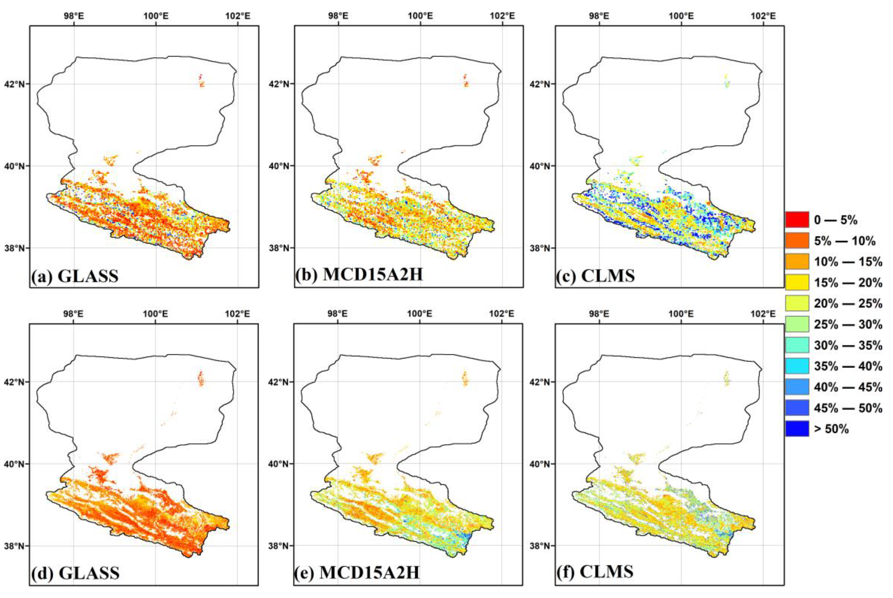
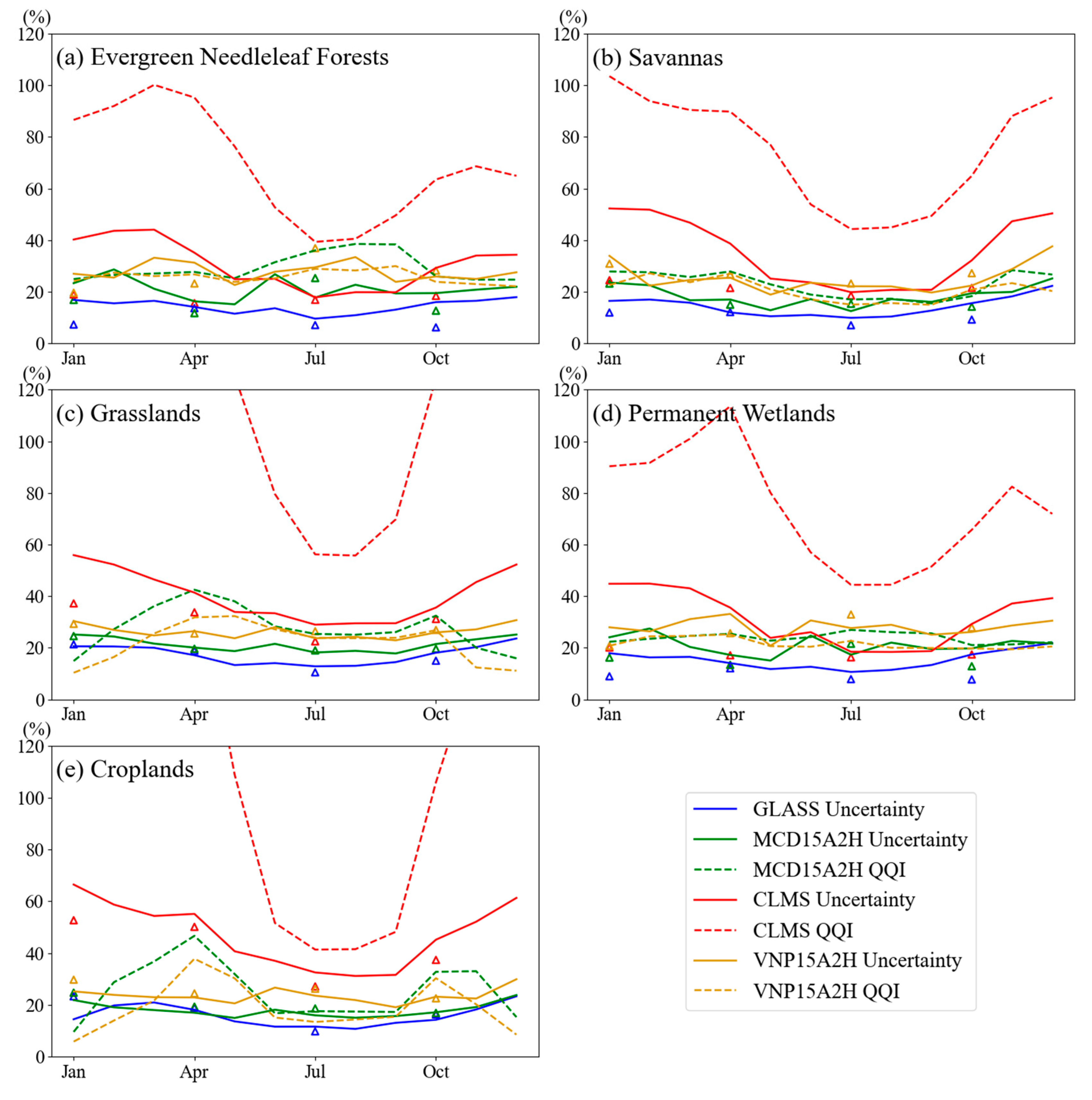
| Product | Needleleaf Forests | Savannas | Grasslands | Permanent Wetlands | Croplands | Overall | |
|---|---|---|---|---|---|---|---|
| Mean LAI | GLASS | 3.17 | 1.51 | 1.13 | 2.68 | 2.18 | 1.27 |
| MCD15A2H | 2.74 | 1.28 | 1.20 | 2.17 | 2.49 | 1.37 | |
| CLMS | 2.61 | 1.77 | 1.21 | 2.40 | 2.51 | 1.37 | |
| VNP15A2H | 2.31 | 1.20 | 1.03 | 2.00 | 2.26 | 1.20 | |
| Uncertainty TCEM | GLASS | 0.24 | 0.16 | 0.13 | 0.24 | 0.22 | 0.14 |
| MCD15A2H | 0.39 | 0.18 | 0.20 | 0.35 | 0.36 | 0.22 | |
| CLMS | 0.43 | 0.34 | 0.33 | 0.41 | 0.71 | 0.37 | |
| VNP15A2H | 0.57 | 0.29 | 0.24 | 0.48 | 0.47 | 0.27 | |
| Relative TCEM (%) | GLASS | 9.55 | 9.87 | 12.81 | 10.63 | 11.57 | 12.64 |
| MCD15A2H | 17.72 | 12.49 | 18.17 | 17.31 | 15.94 | 17.89 | |
| CLMS | 17.80 | 19.81 | 28.95 | 18.45 | 32.51 | 29.27 | |
| VNP15A2H | 29.46 | 22.11 | 23.68 | 27.63 | 23.53 | 23.68 | |
| Uncertainty QQI | GLASS | N/A | N/A | N/A | N/A | N/A | N/A |
| MCD15A2H | 1.01 | 0.23 | 0.23 | 0.63 | 0.44 | 0.26 | |
| CLMS | 0.99 | 0.75 | 0.51 | 0.93 | 0.92 | 0.56 | |
| VNP15A2H | 0.70 | 0.18 | 0.18 | 0.48 | 0.29 | 0.20 | |
| Relative QQI (%) | GLASS | N/A | N/A | N/A | N/A | N/A | N/A |
| MCD15A2H | 36.02 | 16.98 | 25.36 | 26.93 | 17.53 | 24.40 | |
| CLMS | 39.32 | 44.27 | 56.20 | 44.40 | 41.35 | 54.43 | |
| VNP15A2H | 28.88 | 14.99 | 23.91 | 22.67 | 13.38 | 22.51 | |
| valid collocates (%) | 0.19 | 0.21 | 85.97 | 0.53 | 13.10 | 100 |
| Product | Needleleaf Forests | Savannas | Grasslands | Permanent Wetlands | Croplands | Overall | |
|---|---|---|---|---|---|---|---|
| Mean LAI | GLASS | 2.90 | 1.35 | 0.95 | 2.38 | 1.77 | 1.06 |
| MCD15A2H | 2.19 | 1.09 | 0.9 | 1.78 | 1.81 | 1.03 | |
| CLMS | 2.10 | 1.44 | 0.89 | 1.94 | 1.75 | 1.00 | |
| VNP15A2H | 1.85 | 0.96 | 0.77 | 1.50 | 1.62 | 0.88 | |
| Uncertainty TCEM | GLASS | 0.20 | 0.10 | 0.10 | 0.19 | 0.17 | 0.11 |
| MCD15A2H | 0.56 | 0.17 | 0.19 | 0.38 | 0.37 | 0.22 | |
| CLMS | 0.35 | 0.27 | 0.22 | 0.33 | 0.50 | 0.26 | |
| VNP15A2H | 0.66 | 0.23 | 0.23 | 0.48 | 0.45 | 0.27 | |
| Relative TCEM (%) | GLASS | 7.06 | 7.02 | 10.47 | 7.83 | 9.73 | 10.34 |
| MCD15A2H | 25.29 | 15.30 | 18.97 | 21.55 | 18.57 | 18.92 | |
| CLMS | 16.83 | 18.48 | 22.47 | 16.28 | 27.09 | 23.10 | |
| VNP15A2H | 36.88 | 23.18 | 26.40 | 32.88 | 26.23 | 26.40 |
| Product | 1 | 2 | 3 | 4 | 5 | 6 | 7 | 8 | 9 | 10 | 11 | 12 | |
|---|---|---|---|---|---|---|---|---|---|---|---|---|---|
| Uncertainty ≤0.5 (%) | GLASS | 100.0 | 100.0 | 100.0 | 100.0 | 100.0 | 99.7 | 99.6 | 99.5 | 99.8 | 100.0 | 100.0 | 100.0 |
| MCD15A2H | 100.0 | 100.0 | 100.0 | 100.0 | 99.9 | 96.0 | 91.1 | 93.4 | 98.5 | 99.7 | 99.9 | 99.9 | |
| CLMS | 99.9 | 100.0 | 100.0 | 100.0 | 98.7 | 80.4 | 74.5 | 79.5 | 95.2 | 97.9 | 100.0 | 100.0 | |
| VNP15A2H | 100.0 | 100.0 | 100.0 | 100.0 | 99.9 | 93.5 | 86.8 | 91.4 | 98.9 | 99.7 | 100.0 | 100.0 | |
| Relative ≤20% (%) | GLASS | 55.8 | 51.3 | 54.3 | 70.3 | 84.9 | 80.4 | 83.2 | 82.5 | 78.9 | 70.0 | 55.9 | 33.6 |
| MCD15A2H | 37.6 | 40.0 | 49.7 | 58.5 | 66.0 | 53.0 | 65.6 | 62.3 | 67.7 | 54.1 | 45.3 | 39.0 | |
| CLMS | 0.9 | 1.0 | 2.1 | 6.1 | 16.0 | 18.6 | 29.2 | 28.6 | 30.6 | 13.7 | 2.2 | 1.6 | |
| VNP15A2H | 23.7 | 24.7 | 29.1 | 30.1 | 42.9 | 31.1 | 44.3 | 43.2 | 46.8 | 34.9 | 31.0 | 23.1 |
Disclaimer/Publisher’s Note: The statements, opinions and data contained in all publications are solely those of the individual author(s) and contributor(s) and not of MDPI and/or the editor(s). MDPI and/or the editor(s) disclaim responsibility for any injury to people or property resulting from any ideas, methods, instructions or products referred to in the content. |
© 2025 by the authors. Licensee MDPI, Basel, Switzerland. This article is an open access article distributed under the terms and conditions of the Creative Commons Attribution (CC BY) license (https://creativecommons.org/licenses/by/4.0/).
Share and Cite
Zhou, P.; Geng, L.; Li, J.; Wang, H. Intercomparison of Leaf Area Index Products Derived from Satellite Data over the Heihe River Basin. Remote Sens. 2025, 17, 1233. https://doi.org/10.3390/rs17071233
Zhou P, Geng L, Li J, Wang H. Intercomparison of Leaf Area Index Products Derived from Satellite Data over the Heihe River Basin. Remote Sensing. 2025; 17(7):1233. https://doi.org/10.3390/rs17071233
Chicago/Turabian StyleZhou, Pan, Liying Geng, Jun Li, and Haibo Wang. 2025. "Intercomparison of Leaf Area Index Products Derived from Satellite Data over the Heihe River Basin" Remote Sensing 17, no. 7: 1233. https://doi.org/10.3390/rs17071233
APA StyleZhou, P., Geng, L., Li, J., & Wang, H. (2025). Intercomparison of Leaf Area Index Products Derived from Satellite Data over the Heihe River Basin. Remote Sensing, 17(7), 1233. https://doi.org/10.3390/rs17071233


