
Remote Sensing Identification and Analysis of Global Building Electrification (2012–2023)


 ,
, 
Abstract
1. Introduction
2. Study Area and Datasets
2.1. Study Area
2.2. Data
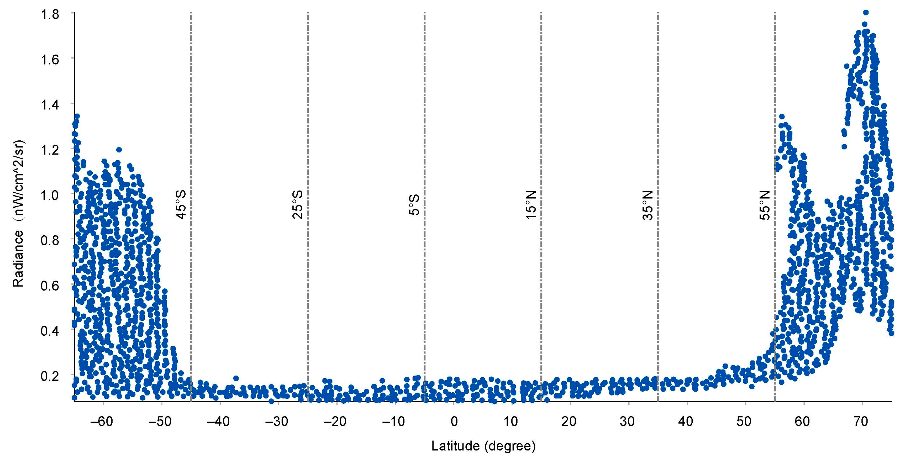
2.2.1. NPP/VIIRS Annual NTL Imagery
2.2.2. Global Human Settlement Layer
2.2.3. ESA_CCI Land Cover Data
2.2.4. Field Survey Data
2.3. Data Preprocessing
3. Methodology
3.1. Sample Creation and Validation
3.2. Regional Identification of Electrified Areas
- (1)
- Image stretching: The 2023 max_VNL and med_VNL data were imported into ArcGIS, and a ‘standard deviation’ stretch method was applied to the image (Gamma = 0.5) to reduce contrast in darker areas and enhance contrast in brighter areas.
- (2)
- Determining the minimum radiance for actual ESs: High-resolution historical imagery and the ESs from the validation set were imported. The radiance of ESs was sorted in ascending order and examined individually until an ES was identified that both fell within a built-up area and exhibited a radiance distinctly different from surrounding pixels in the max_VNL. Its radiance was considered the minimum radiance for actual ESs.
- (3)
- Determining the maximum radiance for actual UNESs: The UNESs from the validation set were imported. Their radiance values were sorted in descending order and examined individually until a UNES was identified that both fell within a non-built-up area and exhibited a radiance consistent with surrounding non-built-up pixels in the med_VNL. Its radiance was considered the maximum radiance for actual UNESs.
- (4)
- Threshold calculation: A traditional mean value method was implemented to segment max_VNL data and distinguish electrified from unelectrified areas. The final output is a series of annual binary global NTL images, using the following calculation method:
3.3. Accuracy Assessment
3.4. Identification of Building Electrification Status
4. Results
4.1. Determination of Thresholds for Electrified Buildings Across Global Regions
4.2. Accuracy Verification
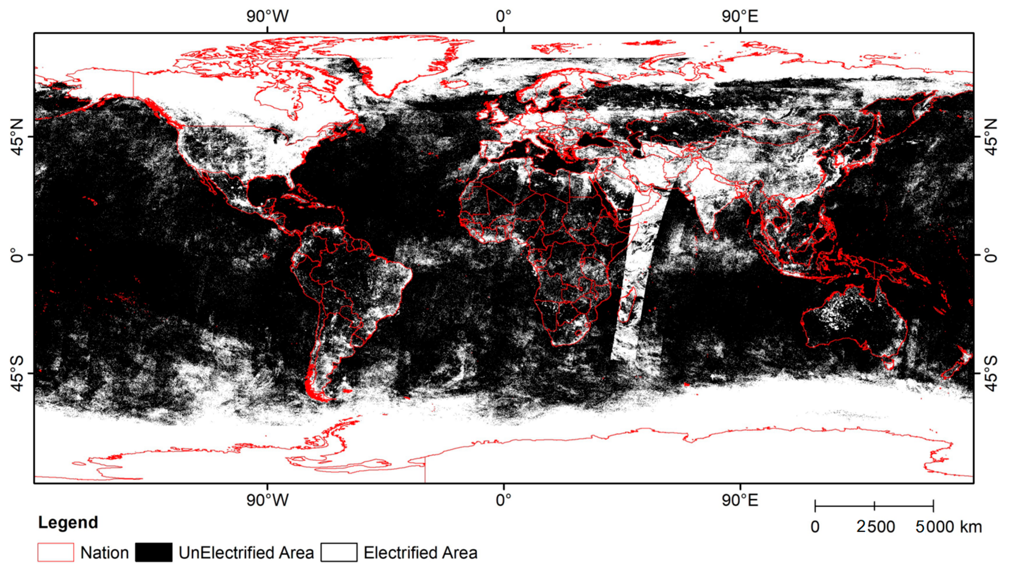
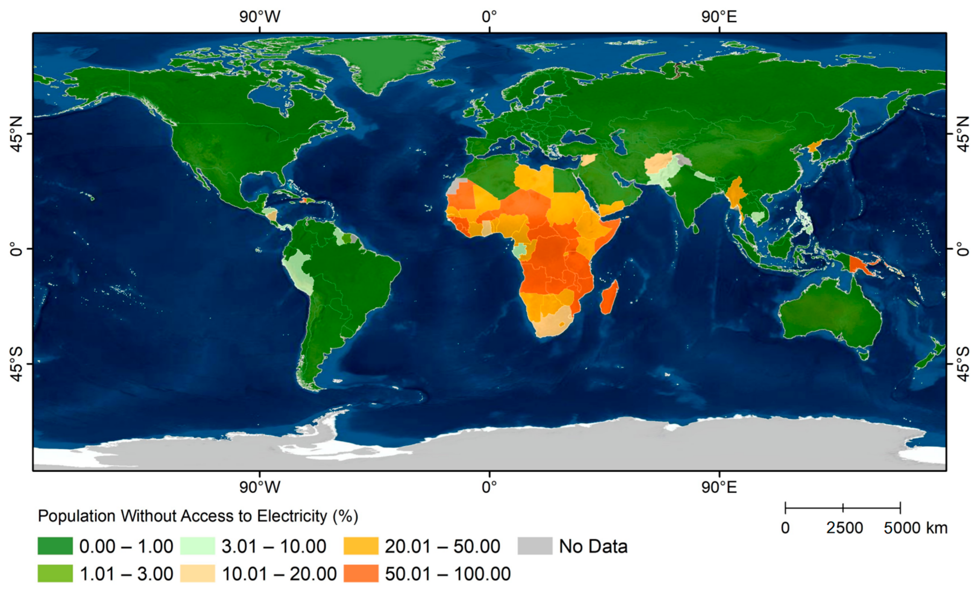
4.3. Global Electrification Status Identification Results
5. Discussion
5.1. Comparison with Existing Methods
5.1.1. Global Accuracy Comparison
5.1.2. Accuracy Comparison in Rural Areas
5.2. Analysis of Global Electrification Status Spatial Distribution Differences
- (1)
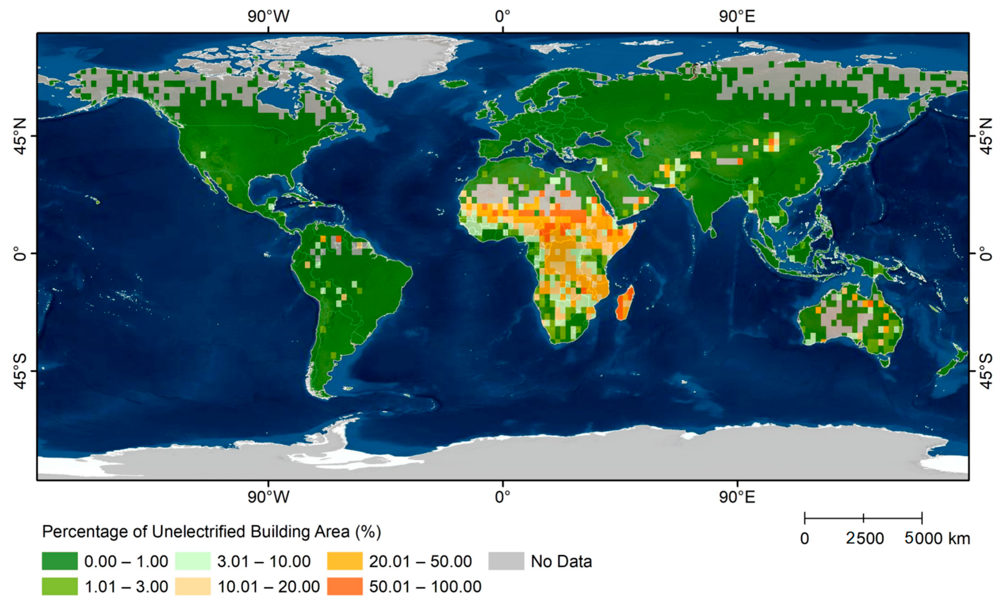
- Regional differences: UNEBs are mainly found in developing countries. In developed nations and countries with mid-to-high development levels, the proportion of UNEBs is 4.07%. These countries have stronger economic foundations and better-developed electrical infrastructure. In contrast, the proportion of UNEBs in Least Developed Countries (LDC), Land Locked Developing Countries (LLDC), and Small Island Developing States (SIDS) is 44.10%, 37.46%, and 29.96%, respectively. Among the top 20 countries with the highest proportion of UNEBs, except for Pitcairn Islands and Norfolk Island, all are developing countries, with 70% located in Sub-Saharan Africa. Although the Pitcairn Islands and Norfolk Island are overseas territories of developed countries, their small size and limited resources result in a relatively high proportion of UNEBs.
- (2)
- Urban–rural differences: UNEBs are primarily concentrated in rural areas of developing countries. Globally, the proportion of UNEBs in rural areas (9.55%) is 11.5 times higher than that in town areas (0.83%). The proportions of UNEBs in city, township, and rural areas are 0.05%, 1.63%, and 98.32%, respectively. In countries where the proportion of UNEBs in towns is ≥1%, all 55 are developing countries, with 40 located in Sub-Saharan Africa. In these countries, the proportions of UNEBs in towns and rural areas are 14.99% and 52.48%, respectively. In rural areas, the proportion of UNEBs in developing countries (13.78%) is 4.23 times higher than in developed countries (3.26%). There are 97 countries where the proportion of UNEBs is ≥10%; except Australia and Uruguay, all are developing countries. The respective proportions of UNEBs in towns and rural areas are 99.36% and 57.79% in Australia, and 100% and 80.71% in Uruguay. Typically, there are small-scale UNEBs in rural areas, and investment in electrical infrastructure may be insufficient.
5.3. Analysis of Temporal Dynamics of Global Electrification Status
5.3.1. Differences in Electrification Status of New Versus Existing Buildings
5.3.2. Comparative Analysis of Electrification Improvement Rates in City, Township, and Rural Areas
5.3.3. Regional Analysis of Global Changes in Building Electrification Status
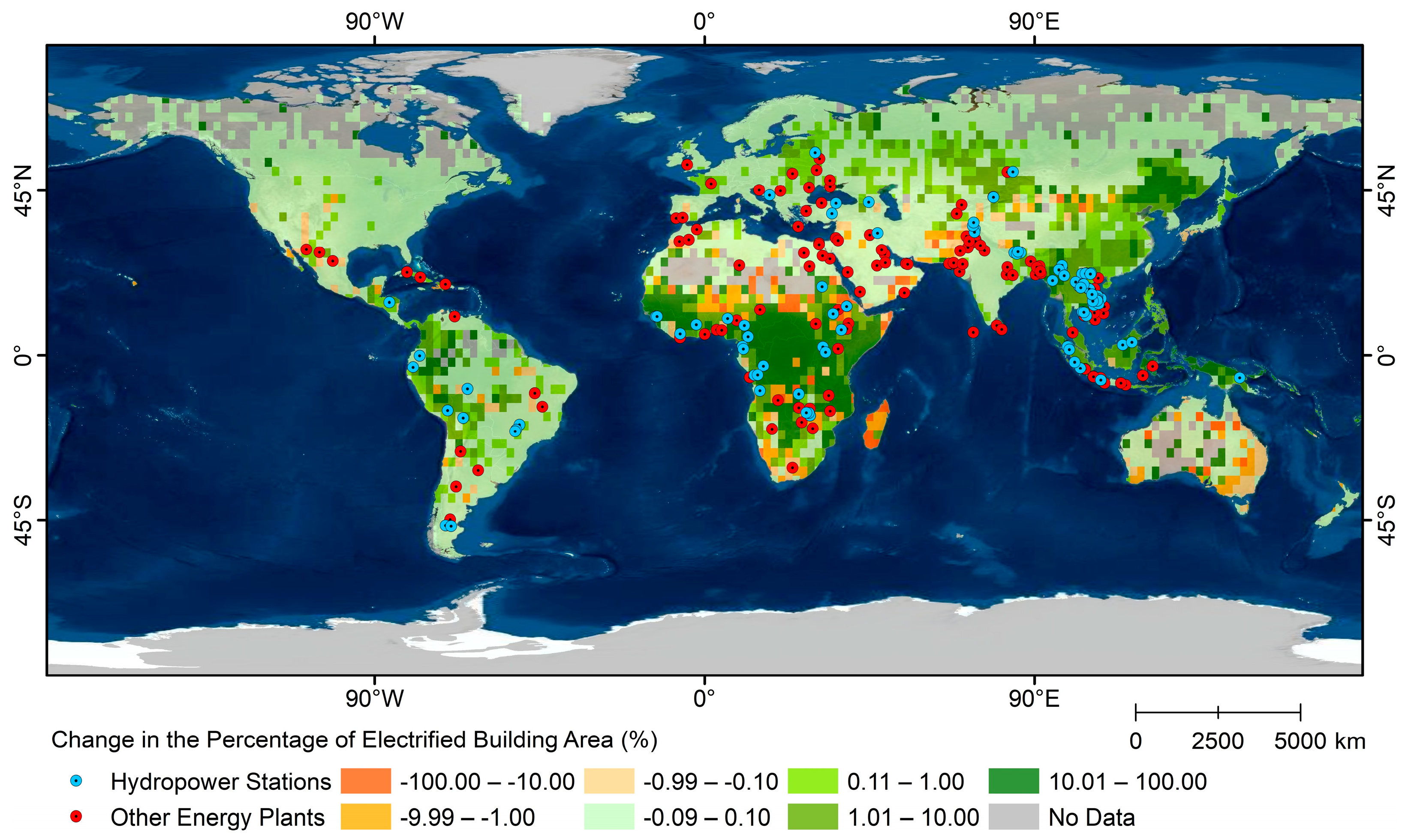
- (1)
- Buildings with improved electrification status are primarily concentrated in the interior regions of Africa and urban areas of Southeast Asia. Economic globalization has led to increased financial and trade openness, boosting electricity supply and narrowing regional electricity gaps [61]. The rise in power stations, especially renewable energy stations, has not only met economic and social needs but also provided stable power for various sectors, such as industry, commerce, and agriculture [62]. In 2023, the proportion of UNEB area decreased by 18.50% in Sub-Saharan Africa and by 28.68% in Southeast Asia. The international community has undertaken several power station projects in these regions, increasing the rate of electrification for buildings. For instance, by 2020, China had invested in 109 hydropower stations and 124 other energy stations (Figure 11) worldwide [63,64]. Among these, 30 hydropower stations and 20 other energy stations were in Sub-Saharan Africa, and 46 hydropower stations and 18 other energy stations were in Southeast Asia. The analysis indicates that the proportion of UNEB area in the 70 countries hosting these 233 stations decreased from 21.03% in 2012 to 11.85% in 2023. Notably, Cambodia experienced the most significant improvement, where China constructed six hydropower stations and one thermal power station, resulting in a 76.71% increase in the EB area.
- (2)
- Buildings with deteriorated electrification status are mainly found in mountainous regions. These areas have low building density, and as urbanization accelerates, populations concentrate in towns and plains, leading to abandoned buildings with no nighttime lighting. Consequently, these buildings are identified as ‘unelectrified’.
5.3.4. Analysis of the Gap in Achieving the 2030 Global Electricity Access Goal
5.4. Analysis of Factors Affecting Global Electrification Status
5.4.1. Impact of the COVID-19 Pandemic
5.4.2. Analysis of the Impact of Extreme Climate Events
5.4.3. Analysis of the Impact of Armed Conflicts
5.5. Analysis of Errors and Limitations
- (1)
- To address noise issues such as aurora pollution in NPP/VIIRS NTL imagery, the regional threshold method and mask-denoising approach were used. Nonetheless, the noise was not completely eliminated. Recent advancements in NTL data processing [24,73,74,75] have further enhanced the quality of NPP/VIIRS datasets by addressing angular effects, geolocation mismatches, and short-term variability. Building on these advancements, future research will explore the potential of higher-quality datasets, including other advanced products such as VNP46A2, VNP46A3, and VNP46A4 from NASA’s NPP/VIIRS Black Marble suite.
- (2)
- The accuracy of the GHS-BUILT-UP-S R2023 dataset is relatively low in Central and Southern Africa (86.4% and 83.8%, respectively) [41]. Errors in depicting built-up areas can reduce the accuracy of identifying the electrification status of dispersed buildings. Meanwhile, the mismatch between the GHSL data and NTL data years may lead to errors. Improving the temporal resolution of built-up area data remains a potential area for future research.
- (3)
- NTL imagery with a spatial resolution of 20 m or higher can more effectively reflect detailed information about built-up areas [76,77]. The 500 m resolution NTL images used in our study provide a relatively coarse assessment of electrification in built-up areas, limiting monitoring capabilities. Future research should utilize higher-resolution data, such as the 10 m resolution NTL data from the Sustainable Development Goals Satellite-1 (SDGSAT-1) [78].
- (4)
- The NPP/VIIRS satellite passes overhead around 01:30 local time. If residents turn off their lights before this, monitoring ‘unelectrified’ buildings may lead to misinterpretation. Therefore, field research should be used to validate the results when applying our product. Notably, numerous recently launched or planned nighttime satellites operate earlier at night. For instance, SDGSAT-1’s NTL imagery is captured around 22:30 local time [78], significantly reducing the risk of misclassifying unelectrified areas. In addition, satellite constellations will be able to reveal the change in upward artificial lighting over the course of the night, with the benefit of finding out the habits of lighting usage.
- (5)
- Natural disasters such as earthquakes, floods, and typhoons can also affect power supply. However, due to their episodic nature and the inherent recovery capacity of cities, it is challenging to assess their impact on building electrification over an annual timescale [28,29]. Future research could estimate these effects using daily NTL imagery [74,79].
- (6)
- Due to the absence of spatial distribution data for known UNEBs, the accuracy assessment focuses solely on the binary global NTL data, which may result in errors in the classification accuracy for UNEBs. Future research could incorporate field survey statistics on UNEBs to further validate and refine classification accuracy.
- (7)
6. Conclusions
- (1)
- The accuracy metrics of our product—Accuracy, Precision, Recall, F1-score, and MCC—were all above 0.9, indicating a high level of accuracy in determining electrification status by combining max_VNL with the regional threshold method. Compared to existing products, Recall for 2014 and 2020 improved by 8.04% and 1.22%, respectively.
- (2)
- In 2023, the global EB area accounted for 91.88%. Meanwhile, there are significant regional and urban–rural disparities in the spatial distribution of UNEBs. Among the top 20 countries with the highest proportions of UNEB areas, 70% are located in Sub-Saharan Africa. Due to the challenges of grid expansion and maintenance, unelectrified buildings are predominantly concentrated in the rural areas of developing countries.
- (3)
- From 2012 to 2023, the global EB area increased by 2.4199 million km2, with rural areas experiencing a faster rate of electrification than town areas. The annual decrease in the UNEB area was approximately 0.62%. To achieve SDG7 by 2030, the rate of reduction in UNEB areas needs to be increased by 1.88 times.
- (4)
- The COVID-19 pandemic, extreme climate events, and armed conflicts are the primary factors affecting global electrification. Power supply in developing countries is particularly vulnerable to external disruptions, necessitating increased investment in stable renewable energy sources to mitigate the impact of these crises on global regions’ power supply, especially those that are fragile.
Supplementary Materials
Author Contributions
Funding
Data Availability Statement
Conflicts of Interest
References
- Rajkumari, L. Relation between electricity consumption and economic growth in Karnataka, India: An aggregate and sector-wise analysis. Electr. J. 2020, 33, 106768. [Google Scholar] [CrossRef]
- Wb. World Bank Database. 2024. Available online: https://data.worldbank.org.cn/indicator/EG.ELC.ACCS.ZS (accessed on 10 February 2025).
- World Health Organization. Tracking SDG7: The Energy Progress Report 2023. 2023. Available online: https://www.iea.org/reports/tracking-sdg7-the-energy-progress-report-2023 (accessed on 1 March 2024).
- Li, D.; Bae, J.H.; Rishi, M. Sustainable development and SDG-7 in Sub-Saharan Africa: Balancing energy access, economic growth, and carbon emissions. Eur. J. Dev. Res. 2023, 35, 112. [Google Scholar] [CrossRef] [PubMed]
- IEA. World Energy Outlook 2019; International Energy Agency: Paris, France, 2019. [Google Scholar]
- IEA. World Energy Outlook 2020; International Energy Agency: Paris, France, 2020. [Google Scholar]
- Guo, H.; Liang, D.; Chen, F.; Sun, Z.; Liu, J. Big earth data facilitates sustainable development goals. Bull. Chin. Acad. Sci. (Chin. Version) 2021, 36, 874–884. [Google Scholar]
- Guo, H. Big Earth Data in Support of the Sustainable Development Goals (2022)—The Belt and Road; Springer: Berlin/Heidelberg, Germany, 2024. [Google Scholar]
- Doll, C.N.; Pachauri, S. Estimating rural populations without access to electricity in developing countries through night-time light satellite imagery. Energy Policy 2010, 38, 5661–5670. [Google Scholar] [CrossRef]
- Elvidge, C.D.; Baugh, K.E.; Sutton, P.C.; Bhaduri, B.; Tuttle, B.T.; Ghosh, T.; Ziskin, D.; Erwin, E.H. Who’s in the dark-satellite based estimates of electrification rates. In Urban Remote Sensing: Monitoring, Synthesis and Modeling in the Urban Environment; Wiley Blackwell: Hoboken, NJ, USA, 2011; pp. 211–224. [Google Scholar]
- Burlig, F.; Preonas, L. Out of the darkness and into the light? development effects of rural electrification. J. Political Econ. 2024, 132, 2937–2971. [Google Scholar] [CrossRef]
- Min, B.; Gaba, K.M.; Sarr, O.F.; Agalassou, A. Detection of rural electrification in Africa using DMSP-OLS night lights imagery. Int. J. Remote Sens. 2013, 34, 8118–8141. [Google Scholar] [CrossRef]
- Min, B.; Gaba, K.M. Tracking electrification in Vietnam using nighttime lights. Remote Sens. 2014, 6, 9511–9529. [Google Scholar] [CrossRef]
- Dugoua, E.; Kennedy, R.; Urpelainen, J. Satellite data for the social sciences: Measuring rural electrification with night-time lights. Int. J. Remote Sens. 2018, 39, 2690–2701. [Google Scholar] [CrossRef]
- Salat, H.; Schläpfer, M.; Smoreda, Z.; Rubrichi, S. Analysing the impact of electrification on rural attractiveness in Senegal with mobile phone data. R. Soc. Open Sci. 2021, 8, 201898. [Google Scholar] [CrossRef] [PubMed]
- Ramdani, F.; Setiani, P. Multiscale assessment of progress of electrification in Indonesia based on brightness level derived from nighttime satellite imagery. Environ. Monit. Assess. 2017, 189, 1–15. [Google Scholar] [CrossRef]
- Bertheau, P.; Oyewo, A.S.; Cader, C.; Breyer, C.; Blechinger, P. Visualizing national electrification scenarios for sub-saharan African countries. Energies 2017, 10, 1899. [Google Scholar] [CrossRef]
- Andrade-Pacheco, R.; Savory, D.J.; Midekisa, A.; Gething, P.W.; Sturrock, H.J.; Bennett, A. Household electricity access in Africa (2000–2013): Closing information gaps with model-based geostatistics. PLoS ONE 2019, 14, e0214635. [Google Scholar] [CrossRef]
- Falchetta, G.; Pachauri, S.; Parkinson, S.; Byers, E. A high-resolution gridded dataset to assess electrification in sub-Saharan Africa. Sci. Data 2019, 6, 110. [Google Scholar] [CrossRef] [PubMed]
- Principe, J.; Takeuchi, W. Supply and demand assessment of solar PV as Off-Grid option in asia pacific region with remotely sensed data. Remote Sens. 2019, 11, 2255. [Google Scholar] [CrossRef]
- Gao, X.; Wu, M.; Niu, Z.; Chen, F. Global Identification of Unelectrified Built-Up Areas by Remote Sensing. Remote Sens. 2022, 14, 1941. [Google Scholar] [CrossRef]
- Elvidge, C.D.; Baugh, K.E.; Zhizhin, M.; Hsu, F.C. Why VIIRS data are superior to DMSP for mapping nighttime lights. Proc. Asia-Pac. Adv. Netw. 2013, 35, 62. [Google Scholar] [CrossRef]
- Elvidge, C.D.; Zhizhin, M.; Ghosh, T.; Hsu, F.C.; Taneja, J. Annual time series of global VIIRS nighttime lights derived from monthly averages: 2012 to 2019. Remote Sens. 2021, 13, 922. [Google Scholar] [CrossRef]
- Li, X.; Ma, R.; Zhang, Q.; Li, D.; Liu, S.; He, T.; Zhao, L. Anisotropic characteristic of artificial light at night–Systematic investigation with VIIRS DNB multi-temporal observations. Remote Sens. Environ. 2019, 233, 111357. [Google Scholar] [CrossRef]
- Elarde, J.; Kim, J.S.; Kavak, H.; Züfle, A.; Anderson, T. Change of human mobility during COVID-19: A United States case study. PLoS ONE 2021, 16, e0259031. [Google Scholar] [CrossRef]
- Xu, G.; Wang, C.; Meng, Q.; Xiu, T.; Li, X. Spatio-temporal variations of night-time lights at early stages of the COVID-19 epidemic in the United States. Natl. Remote Sens. Bull. 2023, 26, 1777–1788. [Google Scholar]
- Chen, Z.; Yu, B.; Ta, N.; Shi, K.; Yang, C.; Wang, C.; Zhao, X.; Deng, S.; Wu, J. Delineating seasonal relationships between Suomi NPP-VIIRS nighttime light and human activity across Shanghai, China. IEEE J. Sel. Top. Appl. Earth Obs. Remote Sens. 2019, 12, 4275–4283. [Google Scholar]
- Yu, B.; Chen, F.; Wang, N.; Wang, L.; Guo, H. Assessing changes in nighttime lighting in the aftermath of the Turkey-Syria earthquake using SDGSAT-1 satellite data. Innovation 2023, 4, 100419. [Google Scholar] [CrossRef]
- Li, X.; Cao, H.; Gong, Y. Earthquake hazard assessment in Turkey and Syria using high-resolution night-light images. Geomat. Inf. Sci. Wuhan Univ. 2023, 48, 1697–1705. [Google Scholar]
- Román, M.O.; Stokes, E.C. Holidays in lights: Tracking cultural patterns in demand for energy services. Earth’s Future 2015, 3, 182–205. [Google Scholar] [CrossRef]
- Levin, N.; Kyba, C.C.; Zhang, Q.; de Miguel, A.S.; Román, M.O.; Li, X.; Portnov, B.A.; Molthan, A.L.; Jechow, A.; Miller, S.D.; et al. Remote sensing of night lights: A review and an outlook for the future. Remote Sens. Environ. 2020, 237, 111443. [Google Scholar] [CrossRef]
- Chen, J.; Zheng, Z.; Wu, Z.; Qian, Q. Review and prospect of application of nighttime light remote sensing data. Prog. Geogr. 2019, 38, 205–223. [Google Scholar]
- Chai, Z.; Wang, S.; Qiao, J. Township GDP estimation of the Pearl River Delta based on the NPP-VIIRS night-time satellite data. Trop. Geogr. 2015, 35, 379–385. [Google Scholar]
- Shi, K.; Yu, B.; Huang, Y.; Hu, Y.; Yin, B.; Chen, Z.; Chen, L.; Wu, J. Evaluating the ability of NPP-VIIRS nighttime light data to estimate the gross domestic product and the electric power consumption of China at multiple scales: A comparison with DMSP-OLS data. Remote Sens. 2014, 6, 1705–1724. [Google Scholar] [CrossRef]
- Li, X.; Chen, Z.; Wu, J.; Wang, W.; Qu, L.; Zhou, S.; Han, X. Gridding methods of city permanent population based on night light data and spatial regression models. J. Geo-Inf. Sci. 2017, 19, 1298–1305. [Google Scholar]
- Gao, Y.; Wang, H.; Wang, P.T.; Sun, X.Y.; Lv, T.T. Population spatial processing for Chinese coastal zones based on census and multiple night light data. Resour. Sci. 2013, 35, 2517–2523. [Google Scholar]
- Hu, Y.; Zhao, G.; Zhang, Q.L. Spatial distribution of population data based on nighttime light and LUC data in the Sichuan-Chongqing Region. J. Geo-Inf. Sci. 2018, 20, 68–78. [Google Scholar]
- Shi, K.; Huang, C.; Yu, B.; Yin, B.; Huang, Y.; Wu, J. Evaluation of NPP-VIIRS night-time light composite data for extracting built-up urban areas. Remote Sens. Lett. 2014, 5, 358–366. [Google Scholar] [CrossRef]
- Cao, Z.Y. Estimating the Spatial Distribution of GDP Based on Nighttime Light Image and Analysis of Correlation Between It and PM2.5 Concentration; Graduate University of Chinese Academy of Sciences (Guangzhou Institute of Geochemistry): Guangzhou, China, 2016. [Google Scholar]
- Burger, W.; Burge, M.J. Digital Image Processing: An Algorithmic Introduction; Springer: Berlin/Heidelberg, Germany, 2022. [Google Scholar]
- European Commission. GHSL Data Package 2023; Publications Office of the European Union: Luxembourg, 2024; Available online: https://human-settlement.emergency.copernicus.eu/download.php?ds=pop (accessed on 1 April 2024).
- Pesaresi, M.; Politis, P. GHS-BUILT-S R2023A—GHS Built-Up Surface Grid, Derived from Sentinel2 Composite and Landsat, Multitemporal (1975–2030) European Commission, Joint Research Centre (JRC). 2023. Available online: http://data.europa.eu/89h/9f06f36f-4b11-47ec-abb0-4f8b7b1d72ea (accessed on 1 March 2024).
- Pesaresi, M.; Huadong, G.; Blaes, X.; Ehrlich, D.; Ferri, S.; Gueguen, L.; Halkia, M.; Kauffmann, M.; Kemper, T.; Lu, L.; et al. A global human settlement layer from optical HR/VHR RS data: Concept and first results. IEEE J. Sel. Top. Appl. Earth Obs. Remote Sens. 2013, 6, 2102–2131. [Google Scholar] [CrossRef]
- Store, C.C.D. Land cover classification gridded maps from 1992 to present derived from satellite observations. Copernic. Clim. Change Serv. 2019, 7–9. [Google Scholar]
- Elvidge, C.D.; Baugh, K.; Zhizhin, M.; Hsu, F.C.; Ghosh, T. VIIRS night-time lights. Int. J. Remote Sens. 2017, 38, 5860–5879. [Google Scholar] [CrossRef]
- Monsivais, D.; Bhattacharya, K.; Ghosh, A.; Dunbar, R.I.; Kaski, K. Seasonal and geographical impact on human resting periods. Sci. Rep. 2017, 7, 10717. [Google Scholar] [CrossRef]
- Shi, Z.; Liu, S.; Xia, H. A remote sensing image registration method combining feature information clustering and partitioning. J. Univ. Chin. Acad. Sci. 2024, 41, 97. [Google Scholar]
- Fan, P.; Chen, J.; Ouyang, Z.; Groisman, P.; Loboda, T.; Gutman, G.; Prishchepov, A.V.; Kvashnina, A.; Messina, J.; Moore, N.; et al. Urbanization and sustainability under transitional economies: A synthesis for Asian Russia. Environ. Res. Lett. 2018, 13, 095007. [Google Scholar] [CrossRef]
- Wang, J.; Qiu, S.; Du, J.; Meng, S.; Wang, C.; Teng, F.; Liu, Y. Spatial and temporal changes of urban built-up area in the Yellow River Basin from nighttime light data. Land 2022, 11, 1067. [Google Scholar] [CrossRef]
- Deng, C.; Zhou, D.; Wang, Y.; Wu, J.; Yin, Z. Association between Land Use and Urban Vitality in the Guangdong–Hong Kong–Macao Greater Bay Area: A Multiscale Study. Land 2024, 13, 1574. [Google Scholar] [CrossRef]
- Wang, J.; Xu, C. Geographic detectors: Principles and prospects. Geogr. J. 2017, 72, 116–134. [Google Scholar]
- Zhou, L.; Divakarla, M.; Liu, X. An overview of the joint polar satellite system (JPSS) science data product calibration and validation. Remote Sens. 2016, 8, 139. [Google Scholar] [CrossRef]
- Corbane, C.; Florczyk, A.; Pesaresi, M.; Politis, P.; Syrris, V. GHS Built-Up Grid, Derived from Landsat, Multitemporal (1975–1990–2000–2014); R2018A; European Commission, Joint Research Centre (JRC): Petten, The Netherlands, 2018. [Google Scholar] [CrossRef]
- Aglina, M.K.; Agbejule, A.; Nyamuame, G.Y. Policy framework on energy access and key development indicators: ECOWAS interventions and the case of Ghana. Energy Policy 2016, 97, 332–342. [Google Scholar] [CrossRef]
- Wassie, Y.T.; Adaramola, M.S. Socio-economic and environmental impacts of rural electrification with Solar Photovoltaic systems: Evidence from southern Ethiopia. Energy Sustain. Dev. 2021, 60, 52–66. [Google Scholar] [CrossRef]
- Daka, K.R.; Ballet, J. Children’s education and home electrification: A case study in northwestern Madagascar. Energy Policy 2011, 39, 2866–2874. [Google Scholar] [CrossRef]
- Markandya, A.; Wilkinson, P. Electricity generation and health. Lancet 2007, 370, 979–990. [Google Scholar] [CrossRef]
- Vernet, A.; Khayesi, J.N.; George, V.; George, G.; Bahaj, A.S. How does energy matter? Rural electrification, entrepreneurship, and community development in Kenya. Energy Policy 2019, 126, 88–98. [Google Scholar] [CrossRef]
- Javadi, F.S.; Rismanchi, B.; Sarraf, M.; Afshar, O.; Saidur, R.; Ping, H.W.; Rahim, N.A. Global policy of rural electrification. Renew. Sustain. Energy Rev. 2013, 19, 402–416. [Google Scholar] [CrossRef]
- Alqahtani, B.J.; Patino-Echeverri, D. Identifying economic and clean strategies to provide electricity in remote rural areas: Main-grid extension vs. Distributed electricity generation. Energies 2023, 16, 958. [Google Scholar] [CrossRef]
- Noumba, I.; Nguea, S.M. Assessing the role of globalization for universal electricity access. Int. Econ. 2023, 174, 180–195. [Google Scholar] [CrossRef]
- Li, X.; Gong, Y.; Shao, Z.; Li, X. Evaluation of China’s Aid to Central Asia from the Perspective of Night-Time Light Remote Sensing. Geomat. Inf. Sci. Wuhan Univ. 2023, 48, 1914–1922. [Google Scholar]
- Yin, F.; Wu, M.; Xiao, J.; Niu, Z. Dataset of China’s overseas hydropower station projects from 2002 to 2019. Chin. Sci. Data 2019, 4. [Google Scholar] [CrossRef]
- Jiang, Y.; Wu, M.; Huang, C.; Niu, Z. China Overseas Power Project Information Dataset 2000–2019. Chin. Sci. Data 2019, 4. [Google Scholar] [CrossRef]
- Vera, C.S.; Osman, M. Activity of the Southern Annular Mode During 2015–2016 El Niño Event and Its Impact on Southern Hemisphere Climate Anomalies. Int. J. Climatol. 2018, 38, e1288–e1295. [Google Scholar] [CrossRef]
- Conway, D.; Dalin, C.; Landman, W.A.; Osborn, T.J. Hydropower plans in eastern and southern Africa increase risk of concurrent climate-related electricity supply disruption. Nat. Energy 2017, 2, 946–953. [Google Scholar] [CrossRef]
- Jamal, T.; Urmee, T.; Calais, M.; Shafiullah, G.M.; Carter, C. Technical challenges of PV deployment into remote Australian electricity networks: A review. Renew. Sustain. Energy Rev. 2017, 77, 1309–1325. [Google Scholar] [CrossRef]
- Brumby, S.; Adams, J.; Kloot, K.; Baker, T.; Hewson, E. O-371 High Heat Days, Thermal Impacts And Emergency Presentations Across Rural Southwest Victoria, Australia. Occup. Med. 2024, 74 (Suppl. 1), 1349. [Google Scholar] [CrossRef]
- Blackberry, I.; Morris, N. The impact of population ageing on rural aged care needs in Australia: Identifying projected gaps in service provision by 2032. Geriatrics 2023, 8, 47. [Google Scholar] [CrossRef]
- Jevtic, M.; Matkovic, V.; Bouland, C. Poverty and energy issues as environmental and health challenges in SDGs. Eur. J. Public Health 2021, 31 (Suppl. 3), ckab164-734. [Google Scholar] [CrossRef]
- Wang, S.; Li, X. Use of Nighttime Light Images in Evaluating Refugee Settlement. IEEE J. Sel. Top. Appl. Earth Obs. Remote Sens. 2024, 17, 14122–14132. [Google Scholar] [CrossRef]
- Li, X.; Liu, S.; Jendryke, M.; Li, D.; Wu, C. Night-time light dynamics during the Iraqi civil war. Remote Sens. 2018, 10, 858. [Google Scholar] [CrossRef]
- Cao, H.; Wang, Y.; Li, X.; Hu, S.; Qiu, S.; Wei, Y. Detecting Farmland Fire in VIIRS Night-time Light Images. Geomat. Inf. Sci. Wuhan Univ. 2023. [Google Scholar] [CrossRef]
- Li, T.; Zhu, Z.; Wang, Z.; Román, M.O.; Kalb, V.L.; Zhao, Y. Continuous monitoring of nighttime light changes based on daily NASA’s Black Marble product suite. Remote Sens. Environ. 2022, 282, 113269. [Google Scholar] [CrossRef]
- Hu, Y.; Zhou XYamazaki, D.; Chen, J. A self-adjusting method to generate daily consistent nighttime light data for the detection of short-term rapid human activities. Remote Sens. Environ. 2024, 304, 114077. [Google Scholar] [CrossRef]
- Zhong, Q.; Xiao, R.; Cao, H.; Li, X.; Wu, J. Evaluation of Venusstar-1 nighttime light images. Geomat. Inf. Sci. Wuhan Univ. 2023, 48, 1273–1285. [Google Scholar]
- Shi, Q.; Zhu, J.; Liu, Z.; Guo, H.; Gao, S.; Liu, M.; Liu, Z.; Liu, X. The Last Puzzle of Global Building Footprints—Mapping 280 Million Buildings in East Asia Based on VHR Images. J. Remote Sens. 2024, 4, 0138. [Google Scholar] [CrossRef]
- Guo, H.; Dou, C.; Chen, H.; Liu, J.; Fu, B.; Li, X.; Zou, Z.; Liang, D. SDGSAT-1: The world’s first scientific satellite for sustainable development goals. Sci. Bull. 2023, 68, 34–38. [Google Scholar] [CrossRef] [PubMed]
- Jia, M.; Li, X.; Gong, Y.; Belabbes, S.; Dell’Oro, L. Estimating natural disaster loss using improved daily night-time light data. Int. J. Appl. Earth Obs. Geoinf. 2023, 120, 103359. [Google Scholar] [CrossRef]


| Time | TN | FP | FN | TP | Accuracy | Precision | Recall | F1-Score | MCC |
|---|---|---|---|---|---|---|---|---|---|
| 2012 | 102,893 | 1653 | 1029 | 103,517 | 0.9872 | 0.9843 | 0.9902 | 0.9872 | 0.9744 |
| 2013 | 101,993 | 2553 | 382 | 104,164 | 0.9860 | 0.9761 | 0.9963 | 0.9861 | 0.9721 |
| 2014 | 102,687 | 1859 | 178 | 104,368 | 0.9903 | 0.9825 | 0.9983 | 0.9903 | 0.9806 |
| 2015 | 100,503 | 4043 | 108 | 104,438 | 0.9801 | 0.9627 | 0.9990 | 0.9805 | 0.9610 |
| 2016 | 102,664 | 1882 | 111 | 104,435 | 0.9905 | 0.9823 | 0.9989 | 0.9905 | 0.9811 |
| 2017 | 99,977 | 4569 | 64 | 104,482 | 0.9778 | 0.9581 | 0.9994 | 0.9783 | 0.9566 |
| 2018 | 102,814 | 1732 | 27 | 104,519 | 0.9916 | 0.9837 | 0.9997 | 0.9917 | 0.9833 |
| 2019 | 99,185 | 5361 | 12 | 104,534 | 0.9743 | 0.9512 | 0.9999 | 0.9749 | 0.9499 |
| 2020 | 103,025 | 1521 | 23 | 104,523 | 0.9926 | 0.9857 | 0.9998 | 0.9927 | 0.9853 |
| 2021 | 102,101 | 2445 | 6 | 104,540 | 0.9883 | 0.9771 | 0.9999 | 0.9884 | 0.9768 |
| 2022 | 101,215 | 3331 | 7 | 104,539 | 0.9840 | 0.9691 | 0.9999 | 0.9843 | 0.9686 |
| 2023 | 101,316 | 3230 | 0 | 104,546 | 0.9846 | 0.9700 | 1.0000 | 0.9848 | 0.9696 |
| Total | 1,220,373 | 34,179 | 1947 | 1,252,605 | 0.9856 | 0.9734 | 0.9984 | 0.9858 | 0.9715 |
| Time | Data | Threshold Selection Method | Classification Threshold (nW·cm⁻2·sr⁻1) | Identification Rate of Villages with Electricity (%) | FN | TP | Recall |
|---|---|---|---|---|---|---|---|
| 2014 | ave_VNL | Single Threshold | 0.35 | 4.17 | 9433 | 95,113 | 0.9098 |
| max_VNL | Single Threshold | 0.4534 | 33.33 | 3061 | 101,485 | 0.9707 | |
| max_VNL | Regional Threshold | 0.2938 | 87.50 | 1029 | 103,517 | 0.9902 | |
| 2020 | ave_VNL | Single Threshold | 0.48 | 54.17 | 1663 | 102,883 | 0.9841 |
| max_VNL | Single Threshold | 0.6578 | 58.33 | 951 | 103,595 | 0.9909 | |
| max_VNL | Regional Threshold | 0.4488 | 100.00 | 382 | 104,164 | 0.9963 |
Disclaimer/Publisher’s Note: The statements, opinions and data contained in all publications are solely those of the individual author(s) and contributor(s) and not of MDPI and/or the editor(s). MDPI and/or the editor(s) disclaim responsibility for any injury to people or property resulting from any ideas, methods, instructions or products referred to in the content. |
© 2025 by the authors. Licensee MDPI, Basel, Switzerland. This article is an open access article distributed under the terms and conditions of the Creative Commons Attribution (CC BY) license (https://creativecommons.org/licenses/by/4.0/).
Share and Cite
Ou, S.; Wu, M.; Niu, Z.; Chen, F.; Liu, J.; Wang, M.; Tian, D. Remote Sensing Identification and Analysis of Global Building Electrification (2012–2023). Remote Sens. 2025, 17, 777. https://doi.org/10.3390/rs17050777
Ou S, Wu M, Niu Z, Chen F, Liu J, Wang M, Tian D. Remote Sensing Identification and Analysis of Global Building Electrification (2012–2023). Remote Sensing. 2025; 17(5):777. https://doi.org/10.3390/rs17050777
Chicago/Turabian StyleOu, Shengya, Mingquan Wu, Zheng Niu, Fang Chen, Jie Liu, Meng Wang, and Dinghui Tian. 2025. "Remote Sensing Identification and Analysis of Global Building Electrification (2012–2023)" Remote Sensing 17, no. 5: 777. https://doi.org/10.3390/rs17050777
APA StyleOu, S., Wu, M., Niu, Z., Chen, F., Liu, J., Wang, M., & Tian, D. (2025). Remote Sensing Identification and Analysis of Global Building Electrification (2012–2023). Remote Sensing, 17(5), 777. https://doi.org/10.3390/rs17050777