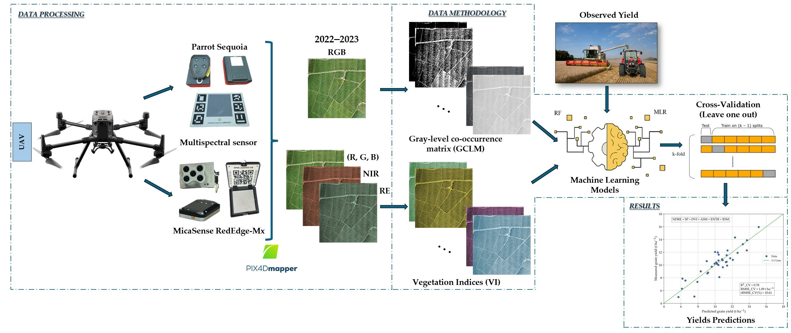
Rice Yield Prediction Using Spectral and Textural Indices Derived from UAV Imagery and Machine Learning Models in Lambayeque, Peru

 ,
,  ,
,  ,
,  ,
,  , and
, and 
Abstract
1. Introduction
2. Materials and Methods
2.1. Study Sites
2.2. Meteorological Characteritics
2.3. Soil Characterization
2.4. Crop Management
2.5. Data Acquisition and Processing
2.5.1. Multispectral and RGB Imaging with an Unmanned Aerial Vehicle (UAV)
2.5.2. Measurement of Rice Grain Yield
2.5.3. Spectral and Textural Index Calculations
2.6. Modeling Methods
2.6.1. Multiple Linear Regression with Sequential Forward Selection (SFS-MLR)
2.6.2. Support Vector Machine-Based Sequential Forward Selection Regression (SFS-SVR)
2.6.3. Random Forest Regression (RFR)
2.7. Model Validation
3. Results
3.1. Relationships Between Yield and Vegetation Indices (VIs) and Textural Indices (TIs)
3.2. Correlation Analysis Between Multiple-Period Vegetation Indices (VIs) and Textural Indices (TIs) and Rice Yield
3.3. Performance of Machine Learning Models for Rice Yield Prediction in 2022, 2023, and Their Combination
3.3.1. Prediction Models with Multiple Linear Regression (MLR) and Support Vector Machine (SVR) Using Sequential Forward Selection (SFS)
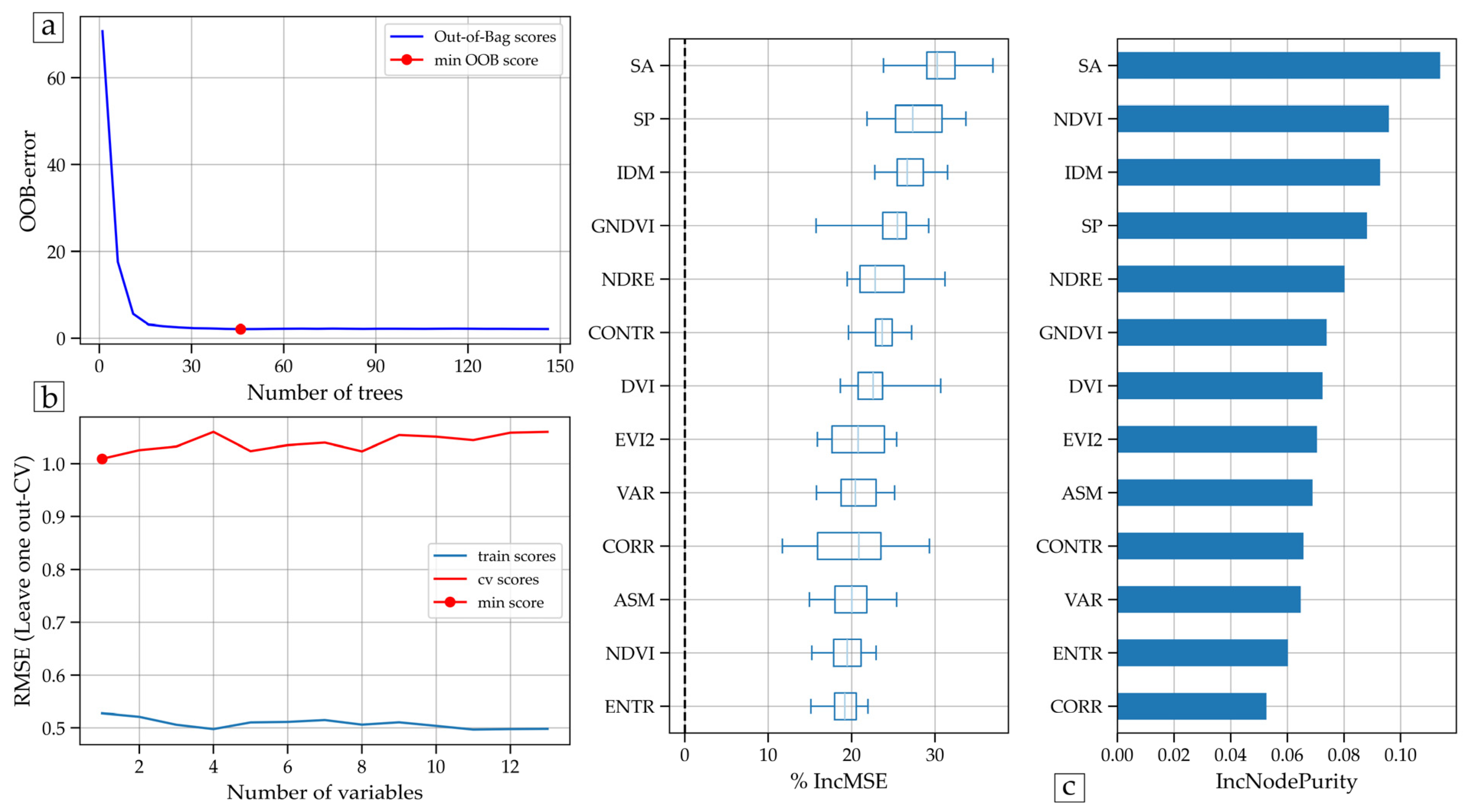
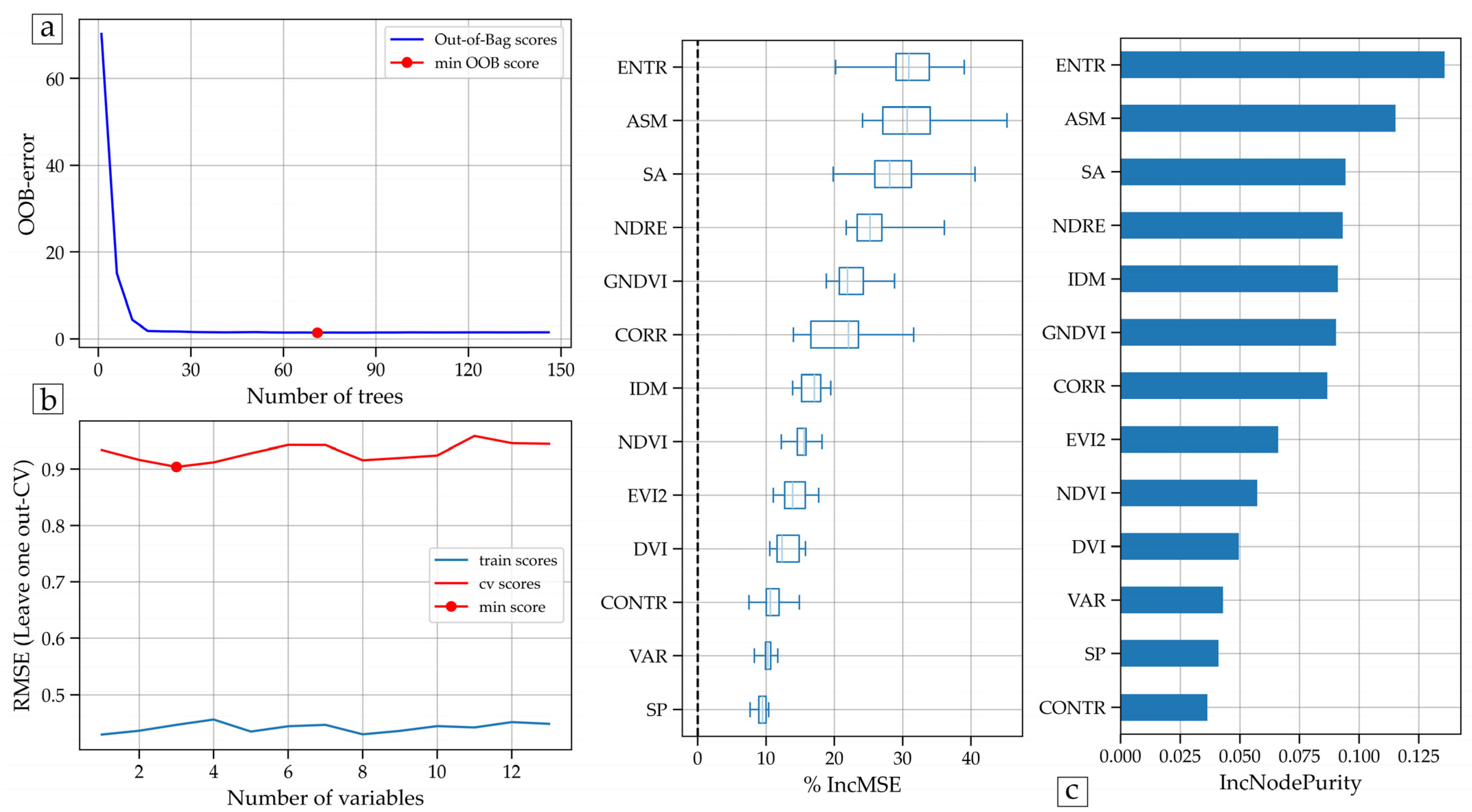
3.3.2. Random Forest (RF)-Based Yield Modeling
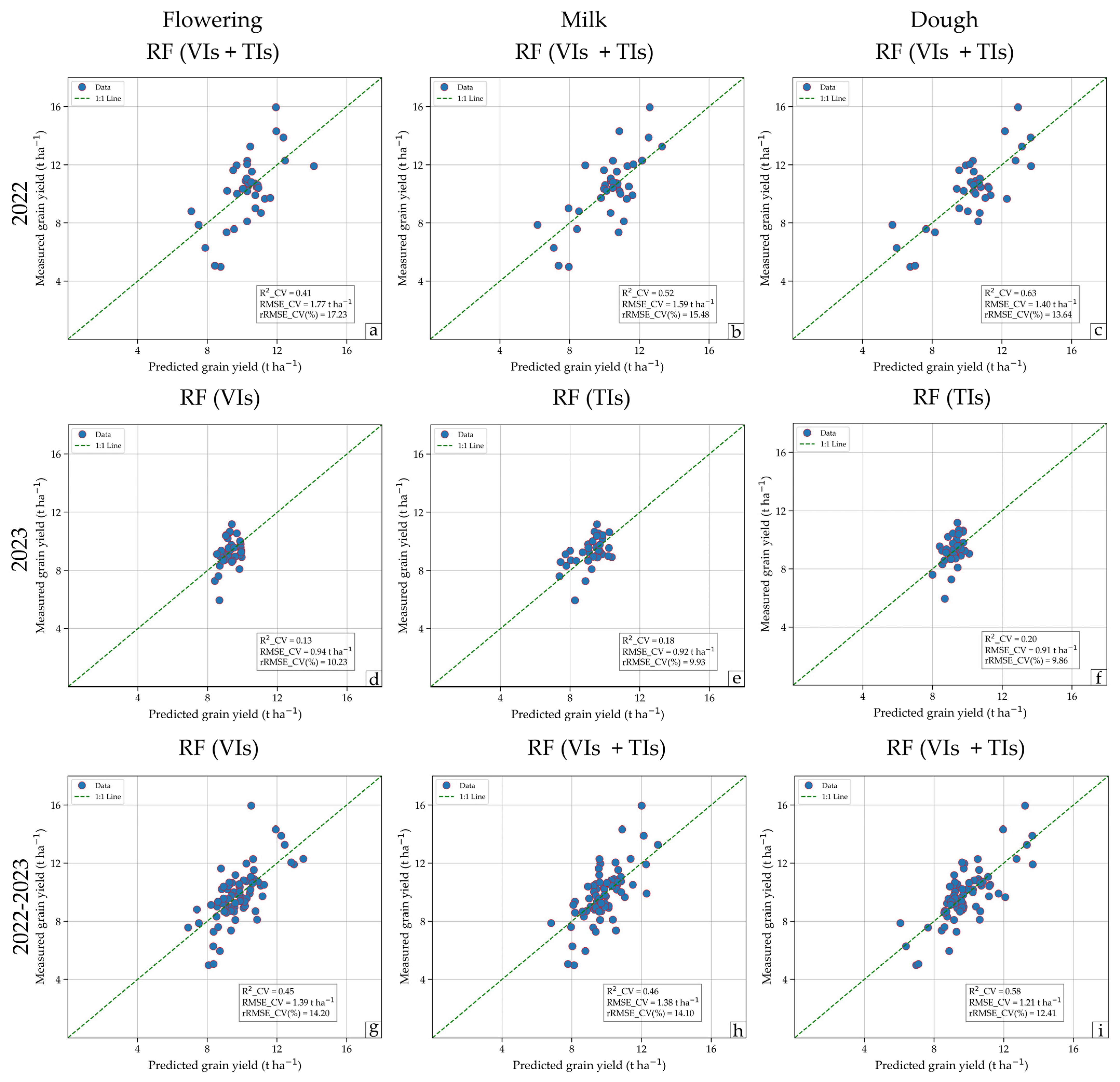
3.3.3. Performance of the Yield Prediction Models
4. Discussion
4.1. Importance of Vegetation and Texture Indices in Rice Yield Prediction
4.2. Temporal Variability of Correlations and Their Impact on Prediction
4.3. Performance of Machine Learning Models in Different Scenarios
4.4. Applicability of the Models and Considerations for Future Prediction
5. Conclusions
Supplementary Materials
Author Contributions
Funding
Data Availability Statement
Acknowledgments
Conflicts of Interest
References
- Xu, T.; Wang, F.; Shi, Z.; Miao, Y. Multi-Scale Monitoring of Rice Aboveground Biomass by Combining Spectral and Textural Information from UAV Hyperspectral Images. Int. J. Appl. Earth Obs. Geoinf. 2024, 127, 103655. [Google Scholar] [CrossRef] [Scilit]
- OECD; FAO. OECD-FAO Agricultural Outlook 2023–2032; OECD Publishing: Paris, France, 2023; ISBN 9789264619333. [Google Scholar]
- Jiang, P.; Zhou, X.; Zhang, L.; Liu, M.; Xiong, H.; Guo, X.; Zhu, Y.; Luo, J.; Chen, L.; Liu, J.; et al. Improving Rice Yield by Promoting Pre-Anathesis Growth in Subtropical Environments. Agronomy 2023, 13, 820. [Google Scholar] [CrossRef] [Scilit]
- FAO. FAO STAT Production Data. Available online: https://www.fao.org/faostat/es/#data/QCL (accessed on 14 March 2024).
- Ramos-Fernández, L.; Gonzales-Quiquia, M.; Huanuqueño-Murillo, J.; Tito-Quispe, D.; Heros-Aguilar, E.; del Pino, L.F.; Torres-Rua, A. Water Stress Index and Stomatal Conductance under Different Irrigation Regimes with Thermal Sensors in Rice Fields on the Northern Coast of Peru. Remote Sens. 2024, 16, 796. [Google Scholar] [CrossRef] [Scilit]
- Mallareddy, M.; Thirumalaikumar, R.; Balasubramanian, P.; Naseeruddin, R.; Nithya, N.; Mariadoss, A.; Eazhilkrishna, N.; Choudhary, A.K.; Deiveegan, M.; Subramanian, E.; et al. Maximizing Water Use Efficiency in Rice Farming: A Comprehensive Review of Innovative Irrigation Management Technologies. Water 2023, 15, 1802. [Google Scholar] [CrossRef] [Scilit]
- Islam, S.M.M.; Gaihre, Y.K.; Islam, M.R.; Islam, A.; Singh, U.; Sander, B.O. Effects of Integrated Plant Nutrition Systems with Fertilizer Deep Placement on Rice Yields and Nitrogen Use Efficiency under Different Irrigation Regimes. Heliyon 2023, 9, e23110. [Google Scholar] [CrossRef] [Scilit]
- Fernandes, A.P.G.; Machado, J.; Fernandes, T.R.; Vasconcelos, M.W.; Carvalho, S.M.P. Water and Nitrogen Fertilization Management in Light of Climate Change: Impacts on Food Security and Product Quality. In Plant Nutrition and Food Security in the Era of Climate Change; Elsevier: Amsterdam, The Netherlands, 2022; pp. 147–178. [Google Scholar]
- Kurihara, J.; Nagata, T.; Tomiyama, H. Rice Yield Prediction in Different Growth Environments Using Unmanned Aerial Vehicle-Based Hyperspectral Imaging. Remote Sens. 2023, 15, 2004. [Google Scholar] [CrossRef] [Scilit]
- Luo, S.; Jiang, X.; Jiao, W.; Yang, K.; Li, Y.; Fang, S. Remotely Sensed Prediction of Rice Yield at Different Growth Durations Using UAV Multispectral Imagery. Agriculture 2022, 12, 1447. [Google Scholar] [CrossRef] [Scilit]
- Zhou, X.; Zheng, H.B.; Xu, X.Q.; He, J.Y.; Ge, X.K.; Yao, X.; Cheng, T.; Zhu, Y.; Cao, W.X.; Tian, Y.C. Predicting Grain Yield in Rice Using Multi-Temporal Vegetation Indices from UAV-Based Multispectral and Digital Imagery. ISPRS J. Photogramm. Remote Sens. 2017, 130, 246–255. [Google Scholar] [CrossRef] [Scilit]
- Franch, B.; Bautista, A.S.; Fita, D.; Rubio, C.; Tarrazó-Serrano, D.; Sánchez, A.; Skakun, S.; Vermote, E.; Becker-Reshef, I.; Uris, A. Within-Field Rice Yield Estimation Based on Sentinel-2 Satellite Data. Remote Sens. 2021, 13, 4095. [Google Scholar] [CrossRef] [Scilit]
- Saravia, D.; Valqui-Valqui, L.; Salazar, W.; Quille-Mamani, J.; Barboza, E.; Porras-Jorge, R.; Injante, P.; Arbizu, C.I. Yield Prediction of Four Bean (Phaseolus vulgaris) Cultivars Using Vegetation Indices Based on Multispectral Images from UAV in an Arid Zone of Peru. Drones 2023, 7, 325. [Google Scholar] [CrossRef] [Scilit]
- Saravia, D.; Salazar, W.; Valqui-Valqui, L.; Quille-Mamani, J.; Porras-Jorge, R.; Corredor, F.-A.; Barboza, E.; Vásquez, H.; Casas Diaz, A.; Arbizu, C. Yield Predictions of Four Hybrids of Maize (Zea mays) Using Multispectral Images Obtained from UAV in the Coast of Peru. Agronomy 2022, 12, 2630. [Google Scholar] [CrossRef] [Scilit]
- Su, X.; Wang, J.; Ding, L.; Lu, J.; Zhang, J.; Yao, X.; Cheng, T.; Zhu, Y.; Cao, W.; Tian, Y. Grain Yield Prediction Using Multi-Temporal UAV-Based Multispectral Vegetation Indices and Endmember Abundance in Rice. Field Crops Res. 2023, 299, 108992. [Google Scholar] [CrossRef] [Scilit]
- Quille-Mamani, J.A.; Ruiz, L.A.; Ramos-Fernández, L. Rice Crop Yield Prediction from Sentinel-2 Imagery Using Phenological Metric. Environ. Sci. Proc. 2023, 28, 16. [Google Scholar] [CrossRef] [Scilit]
- Duan, B.; Fang, S.; Gong, Y.; Peng, Y.; Wu, X.; Zhu, R. Remote Estimation of Grain Yield Based on UAV Data in Different Rice Cultivars under Contrasting Climatic Zone. Field Crops Res. 2021, 267, 108148. [Google Scholar] [CrossRef] [Scilit]
- Nakano, H.; Tanaka, R.; Guan, S.; Ohdan, H. Predicting Rice Grain Yield Using Normalized Difference Vegetation Index from UAV and GreenSeeker. Crop Environ. 2023, 2, 59–65. [Google Scholar] [CrossRef] [Scilit]
- Ji, S.; Gu, C.; Xi, X.; Zhang, Z.; Hong, Q.; Huo, Z.; Zhao, H.; Zhang, R.; Li, B.; Tan, C. Quantitative Monitoring of Leaf Area Index in Rice Based on Hyperspectral Feature Bands and Ridge Regression Algorithm. Remote Sens. 2022, 14, 2777. [Google Scholar] [CrossRef] [Scilit]
- Derraz, R.; Muharam, F.M.; Nurulhuda, K.; Jaafar, N.A.; Yap, N.K. Ensemble and Single Algorithm Models to Handle Multicollinearity of UAV Vegetation Indices for Predicting Rice Biomass. Comput. Electron. Agric. 2023, 205, 107621. [Google Scholar] [CrossRef] [Scilit]
- Wu, Y.; Wang, W.; Gu, Y.; Zheng, H.; Yao, X.; Zhu, Y.; Cao, W.; Cheng, T. SPSI: A Novel Composite Index for Estimating Panicle Number in Winter Wheat before Heading from UAV Multispectral Imagery. Plant Phenomics 2023, 5, 87. [Google Scholar] [CrossRef] [Scilit]
- Mia, M.S.; Tanabe, R.; Habibi, L.N.; Hashimoto, N.; Homma, K.; Maki, M.; Matsui, T.; Tanaka, T.S.T. Multimodal Deep Learning for Rice Yield Prediction Using UAV-Based Multispectral Imagery and Weather Data. Remote Sens. 2023, 15, 2511. [Google Scholar] [CrossRef] [Scilit]
- Zheng, H.; Cheng, T.; Zhou, M.; Li, D.; Yao, X.; Tian, Y.; Cao, W.; Zhu, Y. Improved Estimation of Rice Aboveground Biomass Combining Textural and Spectral Analysis of UAV Imagery. Precis. Agric. 2019, 20, 611–629. [Google Scholar] [CrossRef] [Scilit]
- Wang, F.; Yi, Q.; Hu, J.; Xie, L.; Yao, X.; Xu, T.; Zheng, J. Combining Spectral and Textural Information in UAV Hyperspectral Images to Estimate Rice Grain Yield. Int. J. Appl. Earth Obs. Geoinf. 2021, 102, 102397. [Google Scholar] [CrossRef] [Scilit]
- Kelsey, K.; Neff, J. Estimates of Aboveground Biomass from Texture Analysis of Landsat Imagery. Remote Sens. 2014, 6, 6407–6422. [Google Scholar] [CrossRef] [Scilit]
- Fu, Y.; Yang, G.; Song, X.; Li, Z.; Xu, X.; Feng, H.; Zhao, C. Improved Estimation of Winter Wheat Aboveground Biomass Using Multiscale Textures Extracted from UAV-Based Digital Images and Hyperspectral Feature Analysis. Remote Sens. 2021, 13, 581. [Google Scholar] [CrossRef] [Scilit]
- Ma, Y.; Ma, L.; Zhang, Q.; Huang, C.; Yi, X.; Chen, X.; Hou, T.; Lv, X.; Zhang, Z. Cotton Yield Estimation Based on Vegetation Indices and Texture Features Derived From RGB Image. Front. Plant Sci. 2022, 13, 925986. [Google Scholar] [CrossRef] [Scilit]
- Yang, K.; Gong, Y.; Fang, S.; Duan, B.; Yuan, N.; Peng, Y.; Wu, X.; Zhu, R. Combining Spectral and Texture Features of UAV Images for the Remote Estimation of Rice LAI throughout the Entire Growing Season. Remote Sens. 2021, 13, 3001. [Google Scholar] [CrossRef] [Scilit]
- Yuan, W.; Meng, Y.; Li, Y.; Ji, Z.; Kong, Q.; Gao, R.; Su, Z. Research on Rice Leaf Area Index Estimation Based on Fusion of Texture and Spectral Information. Comput. Electron. Agric. 2023, 211, 108016. [Google Scholar] [CrossRef] [Scilit]
- Karmakar, P.; Teng, S.W.; Murshed, M.; Pang, S.; Li, Y.; Lin, H. Crop Monitoring by Multimodal Remote Sensing: A Review. Remote Sens. Appl. 2024, 33, 101093. [Google Scholar] [CrossRef] [Scilit]
- Mishra, P.; Nordon, A.; Asaari, M.S.M.; Lian, G.; Redfern, S. Fusing Spectral and Textural Information in Near-Infrared Hyperspectral Imaging to Improve Green Tea Classification Modelling. J. Food Eng. 2019, 249, 40–47. [Google Scholar] [CrossRef] [Scilit]
- Dilmurat, K.; Sagan, V.; Moose, S. AI-Driven Maize Yield Forescasting Using Unmanned Aerial Vehicle-Based Hyperspectral and Lidar Data Fusion. ISPRS Ann. Photogramm. Remote Sens. Spat. Inf. Sci. 2022, 3, 193–199. [Google Scholar] [CrossRef] [Scilit]
- Zhang, F.; Hassanzadeh, A.; Letendre, P.; Kikkert, J.; Pethybridge, S.; van Aardt, J. Enhancing Snap Bean Yield Prediction through Synergistic Integration of UAS-Based LiDAR and Multispectral Imagery. Comput. Electron. Agric. 2025, 230, 109923. [Google Scholar] [CrossRef] [Scilit]
- Shawon, S.M.; Ema, F.B.; Mahi, A.K.; Niha, F.L.; Zubair, H.T. Crop Yield Prediction Using Machine Learning: An Extensive and Systematic Literature Review. Smart Agric. Technol. 2025, 10, 100718. [Google Scholar] [CrossRef] [Scilit]
- Yamaguchi, T.; Sasano, K.; Katsura, K. Improving Efficiency of Ground-Truth Data Collection for UAV-Based Rice Growth Estimation Models: Investigating the Effect of Sampling Size on Model Accuracy. Plant Prod. Sci. 2024, 27, 1–13. [Google Scholar] [CrossRef] [Scilit]
- Andrade, C.; Fonseca, A.; Santos, J.A.; Bois, B.; Jones, G.V. Historic Changes and Future Projections in Köppen–Geiger Climate Classifications in Major Wine Regions Worldwide. Climate 2024, 12, 94. [Google Scholar] [CrossRef] [Scilit]
- Porras-Jorge, R.; Ramos-Fernández, L.; Ojeda-Bustamante, W.; Ontiveros-Capurata, R. Performance Assessment of the AquaCrop Model to Estimate Rice Yields under Alternate Wetting and Drying Irrigation in the Coast of Peru. Sci. Agropecu. 2020, 11, 309–321. [Google Scholar] [CrossRef] [Scilit]
- Biswal, S.; Pathak, N.; Chatterjee, C.; Mailapalli, D.R. Estimation of Aboveground Biomass from Spectral and Textural Characteristics of Paddy Crop Using UAV-Multispectral Images and Machine Learning Techniques. Geocarto Int. 2024, 39, 2364725. [Google Scholar] [CrossRef] [Scilit]
- Haralick, R.M.; Dinstein, I.; Shanmugam, K. Textural Features for Image Classification. IEEE Trans. Syst. Man. Cybern. 1973, SMC-3, 610–621. [Google Scholar] [CrossRef] [Scilit]
- Antoniol, G.; Basco, C.; Ceccarelli, M.; Markus, M.; Moritz, L. r.texture—Generate Images with Textural Features From a Raster Map. Available online: https://grass.osgeo.org/grass-stable/manuals/r.texture.html (accessed on 10 October 2024).
- Moreno-García, B.; Guillén, M.; Casterad, M.A.; Quílez, D. Uso de imágenes aéreas multiespectrales para estimación del rendimiento en cultivo de arroz. Teledetección: Sistemas Operacionales de Observación de la Tierra, Actas del XV Congreso de la Asociación Española de Teledetección, Madrid. 2013, pp. 357–560. Available online: http://www.aet.org.es/?q=congresos (accessed on 20 November 2024).
- Balabin, R.M.; Lomakina, E.I. Support Vector Machine Regression (SVR/LS-SVM)—An Alternative to Neural Networks (ANN) for Analytical Chemistry? Comparison of Nonlinear Methods on near Infrared (NIR) Spectroscopy Data. Analyst 2011, 136, 1703–1712. [Google Scholar] [CrossRef] [Scilit]
- Raschka, S. MLxtend: Providing Machine Learning and Data Science Utilities and Extensions to Python’s Scientific Computing Stack. J. Open Source Softw. 2018, 3, 638. [Google Scholar] [CrossRef] [Scilit]
- Zhang, C.; Xue, Y. Estimation of Biochemical Pigment Content in Poplar Leaves Using Proximal Multispectral Imaging and Regression Modeling Combined with Feature Selection. Sensors 2023, 24, 217. [Google Scholar] [CrossRef] [Scilit]
- Raschka, S.; Mirjalili, V. Python Machine Learning, 3rd ed.; Packt Publishing: Birmingham, UK, 2019; Volume 1, ISBN 9781789955750. [Google Scholar]
- Fawagreh, K.; Gaber, M.M.; Elyan, E. Random Forests: From Early Developments to Recent Advancements. Syst. Sci. Control Eng. 2014, 2, 602–609. [Google Scholar] [CrossRef] [Scilit]
- Moisen, G. Classification and Regression Trees. In Encyclopedia of Ecology; Elsevier: Kidlington, OX, USA, 2008; Volume 1. [Google Scholar]
- Keith, T.Z. Multiple Regression and Beyond, 2nd ed.; Routledge: New York, NY, USA, 2015. [Google Scholar]
- MIDAGRI. Impact of Cyclone Yaku on the Agriculture and Livestock Sector. Available online: https://repositorio.midagri.gob.pe/ (accessed on 14 October 2023).
- Shourie, A.; Singh, A. Impact of Climate Change on Soil Fertility. In Climate Change and the Microbiome. Soil Biology; Springer: Cham, Switzerland, 2021; Volume 63, pp. 49–62. [Google Scholar] [CrossRef] [Scilit]
- Warner, J.; Alaica, A.K. Contextualizing the Influence of Climate and Culture on Bivalve Populations: Donax Obesulus Malacology from the North Coast of Peru. J. Isl. Coast. Archaeol. 2024, 19, 150–171. [Google Scholar] [CrossRef] [Scilit]
- Wan, L.; Cen, H.; Zhu, J.; Zhang, J.; Zhu, Y.; Sun, D.; Du, X.; Zhai, L.; Weng, H.; Li, Y.; et al. Grain Yield Prediction of Rice Using Multi-Temporal UAV-Based RGB and Multispectral Images and Model Transfer—A Case Study of Small Farmlands in the South of China. Agric. For. Meteorol. 2020, 291, 108096. [Google Scholar] [CrossRef] [Scilit]
- Yglesias-González, M.; Valdés-Velásquez, A.; Hartinger, S.M.; Takahashi, K.; Salvatierra, G.; Velarde, R.; Contreras, A.; María, H.S.; Romanello, M.; Paz-Soldán, V.; et al. Reflections on the Impact and Response to the Peruvian 2017 Coastal El Niño Event: Looking to the Past to Prepare for the Future. PLoS ONE 2023, 18, e0290767. [Google Scholar] [CrossRef] [Scilit] [PubMed]

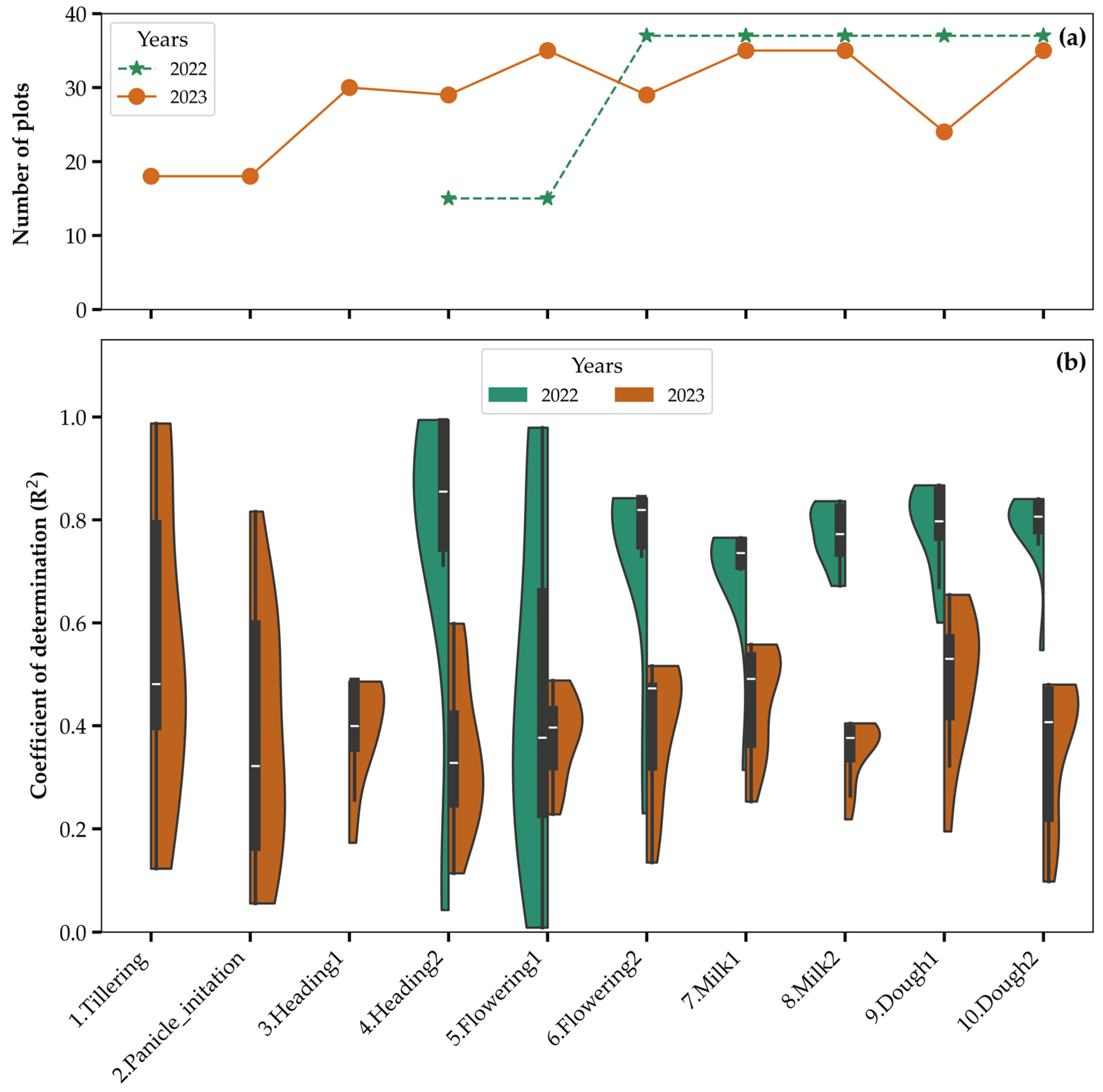
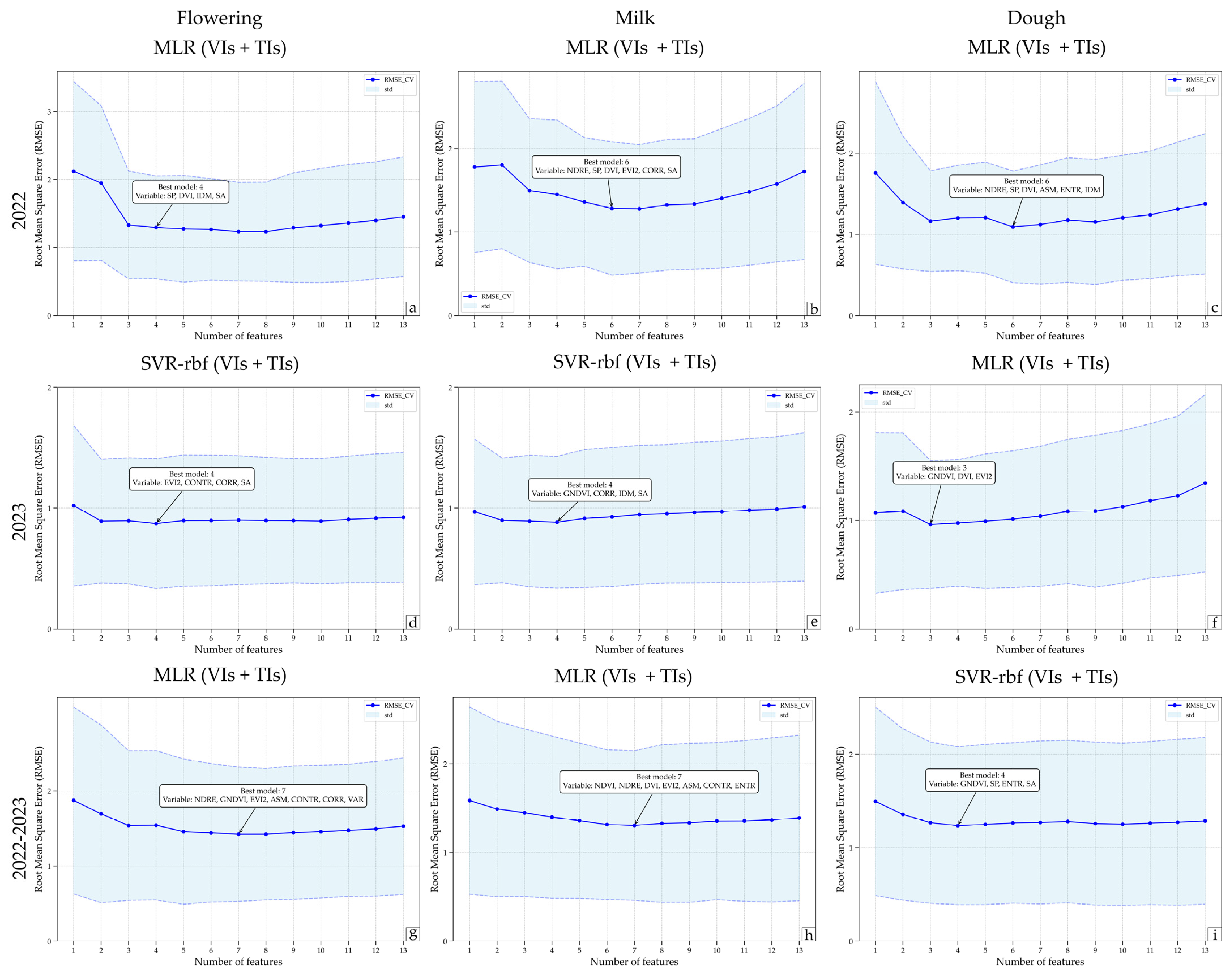
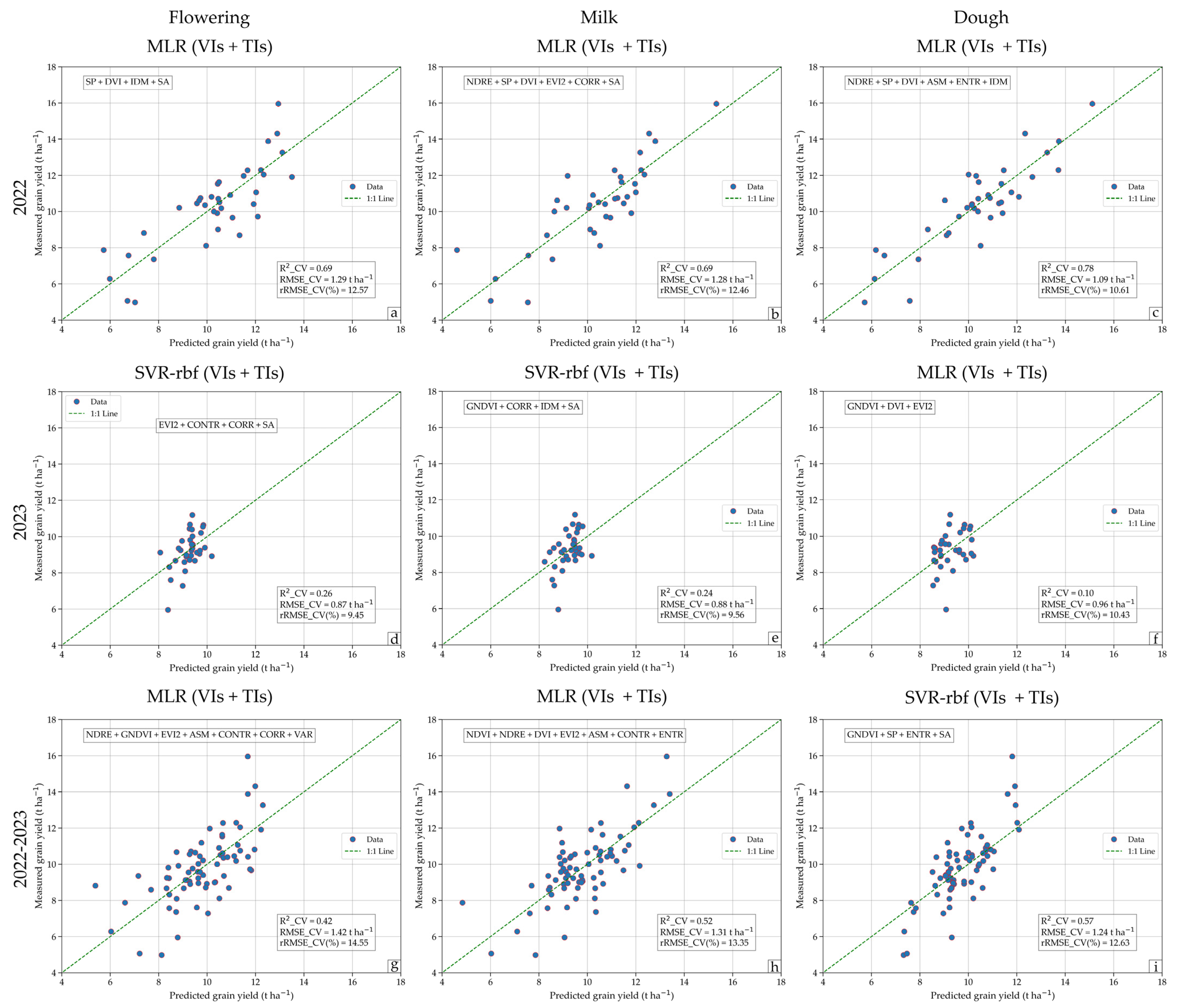
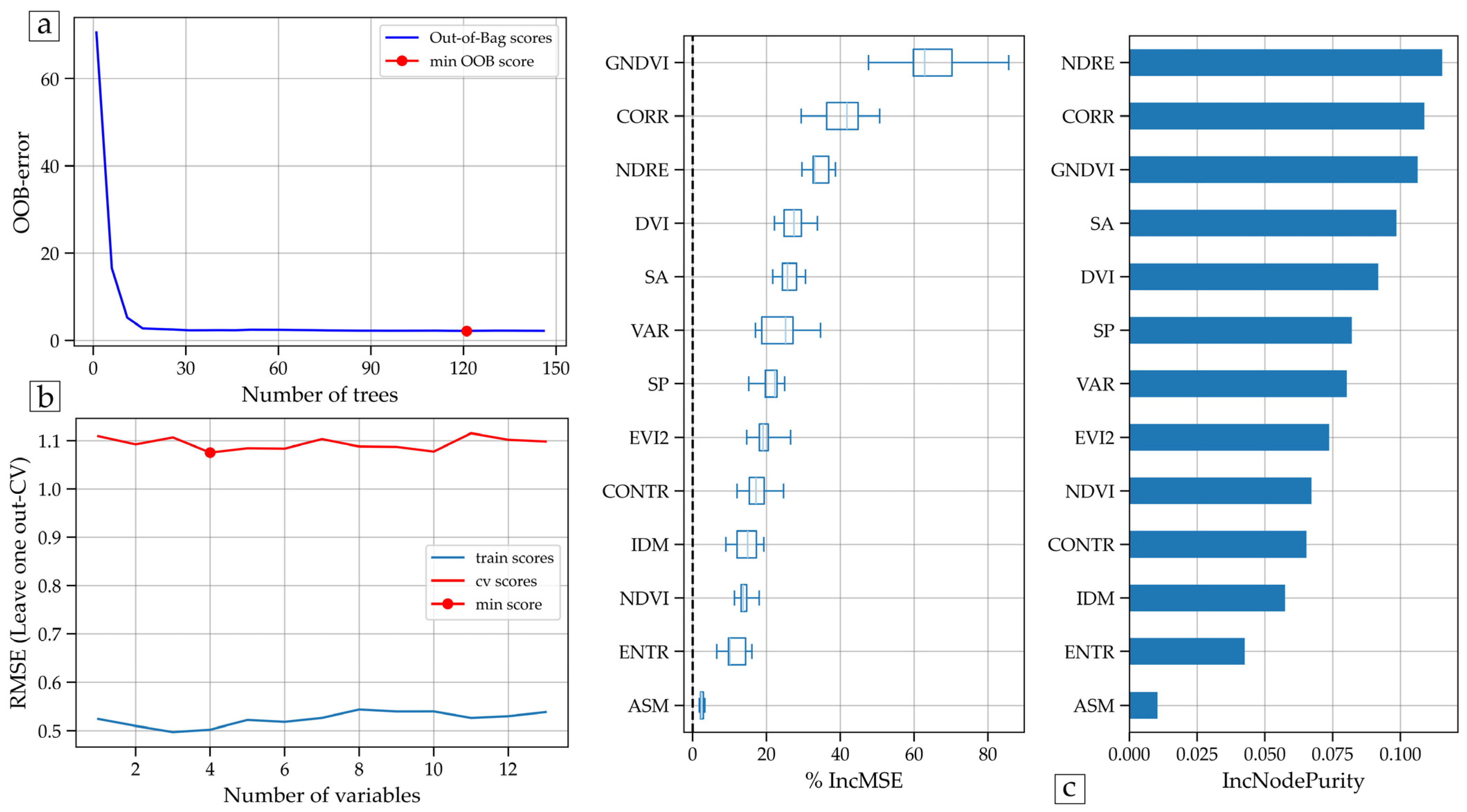

| Zones | Longitude | Latitude | Altitude (m.a.s.l.) | Area (ha) | Sub-plots | Variety |
|---|---|---|---|---|---|---|
| Caballito | 06°35′38.82″S | 79°47′5.32″W | 47 | 14.19 | 15 | Tinajone and Capoteña |
| Garcia | 06°35′2.51″S | 79°47′3.50″W | 47 | 5.23 | 3 | Tinajones |
| Santa Julia | 06°36′25.99”S | 79°47′31.85″W | 42 | 8.55 | 7 | Mallares |
| Totora | 06°35′35.16″S | 79°47′32.74″W | 44 | 5.38 | 6 | Puntilla |
| Zapote | 06°35′44.20″S | 79°47′8.04″W | 46 | 6.01 | 6 | Pakamuros |
| Zones | Soil Texture | Bulk Density (g cm−3) | Real Density (g cm−3) | Field Capacity (%) | Permanent Wilting Point (%) |
|---|---|---|---|---|---|
| Caballito | Sandy loam | 1.45 | 2.33 | 24.24 ± 0.96 | 22.54 ± 1.33 |
| García | Sandy loam | 1.47 | 2.47 | 23.31 ± 0.73 | 12.33 ± 0.27 |
| Santa Julia | Clay loam | 1.46 | 2.56 | 20.38 ± 0.53 | 11.79 ± 0.37 |
| Totora | Clay loam | 1.53 | 2.6 | 17.79 ± 1.01 | 10.24 ± 0.50 |
| Zapote | Clay loam | 1.4 | 2.53 | 29.50 ± 1.96 | 16.58 ± 0.53 |
| Variety | Flight Date and Days Post Sowing (DPS) | |||||||||
|---|---|---|---|---|---|---|---|---|---|---|
| Tinajones y Capoteña (Caballito) | Tinajones (Garcia) | Mallares (Santa Julia) | Puntilla (Totora) | Pakamuros (Zapote) | ||||||
| Growth Stage | 2022 | 2023 | 2022 | 2023 | 2022 | 2023 | 2022 | 2023 | 2022 | 2023 |
| Tillering | * | 06-March (67) | * | 06-March (67) | * | * | * | * | * | * |
| Panicle Initiation | * | 10-March (71) | * | 10-March (71) | * | * | * | * | * | * |
| Heading Stage | * | 20-March (81) | * | 20-March (81) | * | * | * | * | * | 06-March (81) |
| Heading Stage | 17-March (83) | 24-March (85) | * | 24-March (85) | * | 20-March (89) | * | 06-March (83) | * | 10-March (85) |
| Flowering Stage | 22-March (88) | 02-April (94) | 17-March (97) | 02-April (94) | * | 24-March (93) | * | 20-March (97) | * | 20-March (95) |
| Flowering Stage | 01-April (98) | 06-April (98) | 22-March (102) | 06-April (98) | 17-March (100) | 02-April (102) | 17-March (98) | 24-March (101) | 17-March (102) | 24-March (99) |
| Milk Stage | 09-April (106) | 17-April (109) | 01-April (112) | 17-April (109) | 22-March (105) | 06-April (106) | 22-Mar (103) | 02-April (110) | 22-March (107) | 02-April (108) |
| Milk Stage | 20-April (117) | 21-April (113) | 09-April (120) | 21-April (113) | 01-April (115) | 17-April (117) | 01-April (113) | 06-April (114) | 01-April (117) | 06-April (112) |
| Dough Stage | 26-April (123) | 07-May (129) | 20-April (131) | 07-May (129) | 09-April (123) | 21-April (121) | 09-April (121) | 17-April (125) | 09-April (125) | 21-April (127) |
| Dough Stage | 06-May (133) | 11-May (133) | 26-April (137) | 11-May (133) | 20-April (134) | 07-May (137) | 20-April (132) | 21-April (129) | 20-April (136) | 31-May (167) |
| Maturity | * | * | 06-May (147) | * | * | 11-May (141) | 26-April (138) | 07-May (145) | 26-April (142) | * |
| Harvest | * | * | * | * | * | * | 06-May (148) | 11-May (149) | 06-May (152) | * |
| Band Name | MicaSense RedEdge-Mx | Parrot Sequoia |
|---|---|---|
| Blue | 459–491 nm | – |
| Green | 546.5–573.5 nm | 480–520 nm |
| Red | 661–675 nm | 640–680 nm |
| Red-edge | 711–723 nm | 730–740 nm |
| Near-infrared | 813.5–870.5 nm | 770–810 nm |
| Zones | Resolution (cm Pixel−1) | Frontal and Lateral Overlap (%) | Velocity (m s−1) | Height (m) | Time of Flight | Area (m2) |
|---|---|---|---|---|---|---|
| Caballito | 7 | 85 × 80 | 8.6 | 120 | 12′51″ | 181,000 |
| García | 7 | 85 × 80 | 8.6 | 120 | 5′ | 76,000 |
| Santa Julia | 7 | 85 × 80 | 8.6 | 120 | 7′ 50″ | 109,000 |
| Totora | 7 | 85 × 80 | 8.6 | 120 | 5′41″ | 74,000 |
| Zapote | 7 | 85 × 80 | 8.6 | 120 | 19′54″ | 72,000 |
| Spectral Indices | Calculation Formula | Sources |
|---|---|---|
| Normalized Difference Vegetation Index (NDVI) | [16,18,19,41] | |
| Simple Ratio (SP) | [1,11,19,29] | |
| Difference Vegetation Index (DVI) | [11,17,19] | |
| Normalized Difference Red Edge (NDRE) | [13,14,15] | |
| Green Normalized Difference Vegetation Index (GNDVI) | [14,15] | |
| Enhanced Vegetation Index 2 (EVI 2) | [15,17,21] |
| Texture Indices | Calculation Formula | Sources |
|---|---|---|
| Angular Second Moment (ENE) | [1,29] | |
| Entropy (ENT) | [25] | |
| Correlation (COR) | [25,31] | |
| Inverse Difference Moment (IDM) | [31] | |
| Contrast (CON) | [1,29] | |
| Sum Average (SA) | [1] | |
| Variance (VAR) | [25,31] |
| Spectral and Textural Characteristics | Correlation Coefficients (r) | ||||||||
|---|---|---|---|---|---|---|---|---|---|
| Flowering | Milk | Dough | |||||||
| 2022 | 2023 | 2022–2023 | 2022 | 2023 | 2022–2023 | 2022 | 2023 | 2022–2023 | |
| NDVI | 0.01 ns | 0.15 ns | −0.14 ns | 0.55 *** | 0.27 ns | 0.40 *** | 0.59 *** | 0.02 ns | 0.42 *** |
| NDRE | 0.06 ns | 0.46 ** | 0.11 ns | 0.63 *** | 0.35 * | 0.57 *** | 0.71 *** | 0.14 ns | 0.56 *** |
| GNDVI | −0.16 ns | 0.28 ns | −0.24 * | 0.61 *** | 0.44 ** | 0.45 *** | 0.73 *** | 0.12 ns | 0.49 *** |
| SP | 0.02 ns | 0.11 ns | −0.13 ns | 0.47 ** | 0.26 ns | 0.38 *** | 0.49 ** | 0.03 ns | 0.43 *** |
| DVI | 0.50 ** | 0.01 ns | −0.04 ns | 0.69 *** | −0.17 ns | −0.04 ns | 0.60 *** | 0.01 ns | 0.18 ns |
| EVI2 | 0.41 * | 0.01 ns | −0.04 ns | 0.68 *** | −0.13 ns | 0.03 ns | 0.59 *** | −0.01 ns | 0.28 * |
| ASM | 0.11 ns | −0.09 ns | 0.22 ns | 0.43 ** | −0.40 * | 0.40 *** | 0.59 *** | −0.15 ns | 0.52 *** |
| CONTR | −0.49 ** | −0.29 ns | −0.29 * | −0.07 ns | 0.40 * | −0.09 ns | −0.34 * | 0.20 ns | −0.08 ns |
| CORR | −0.25 ns | −0.01 ns | −0.32 * | −0.17 ns | −0.31 ns | −0.32 ** | −0.59 *** | −0.09 ns | −0.47 *** |
| ENTR | −0.12 ns | 0.07 ns | −0.23 * | −0.32 ns | 0.34 * | −0.34 ** | −0.64 *** | 0.19 ns | −0.49 *** |
| IDM | 0.15 ns | −0.04 ns | 0.26 * | 0.24 ns | −0.50 ** | 0.30 * | 0.42 * | −0.24 ns | 0.36 ** |
| SA | −0.16 ns | 0.23 ns | −0.24 * | −0.21 ns | 0.04 ns | −0.33 ** | −0.45 ** | −0.14 ns | −0.48 *** |
| VAR | −0.50 ** | −0.30 ns | −0.29 * | −0.07 ns | 0.39 * | −0.10 ns | −0.36 * | 0.20 ns | −0.09 ns |
| Machine Learning Models | Validation (Leave-One-Out CV) | ||||||||
|---|---|---|---|---|---|---|---|---|---|
| Flowering | Milk | Dough | |||||||
| _CV | RMSE_CV (t ha−1) | rRMSE_CV (%) | R2_CV | ) | rRMSE_CV (%) | R2_CV | RMSE_CV (t ha−1) | rRMSE_CV (%) | |
| Vegetation Index (VI) | |||||||||
| Multiple Linear Regression (MLR) | 0.67 | 1.33 (0.80) | 12.94 (7.75) | 0.58 | 1.50 (0.86) | 14.54 (8.36) | 0.75 | 1.16 (0.62) | 11.29 (6.02) |
| Support Vector Machine (SVR-linear) | 0.52 | 1.61 (1.06) | 15.59 (10.31) | 0.44 | 1.72 (1.03) | 16.71 (10.05) | 0.66 | 1.35 (0.86) | 13.09 (8.38) |
| Support Vector Machine (SVR-rbf) | 0.47 | 1.68 (1.15) | 16.35 (11.14) | 0.39 | 1.81 (1.19) | 17.55 (11.60) | 0.52 | 1.59 (1.02) | 15.46 (9.91) |
| Random Forest (RF) | 0.32 | 1.90 (1.36) | 18.45 (13.21) | 0.43 | 1.75 (1.01) | 16.95 (9.83) | 0.50 | 1.64 (1.02) | 15.91 (9.94) |
| Texture Index (TI) | |||||||||
| Multiple Linear Regression (MLR) | 0.15 | 2.13 (1.27) | 20.68 (12.31) | 0.22 | 2.04 (1.25) | 19.77 (12.15) | 0.59 | 1.48 (0.92) | 14.34 (8.96) |
| Support Vector Machine (SVR-linear) | 0.20 | 2.07 (1.36) | 20.07 (13.21) | 0.25 | 2.00 (1.31) | 19.45 (12.77) | 0.60 | 1.45 (0.98) | 14.12 (9.53) |
| Support Vector Machine (SVR-rbf) | 0.40 | 1.79 (1.19) | 17.34 (11.59) | 0.32 | 1.91 (1.21) | 18.51 (11.75) | 0.51 | 1.61 (1.08) | 15.68 (10.52) |
| Random Forest (RF) | 0.26 | 1.98 (1.19) | 19.22 (11.53) | 0.15 | 2.13 (1.43) | 20.72 (13.92) | 0.50 | 1.64 (1.04) | 15.91 (10.13) |
| all (IV+TI) | |||||||||
| Multiple Linear Regression (MLR) | 0.69 | 1.29 (0.76) | 12.57 (7.33) | 0.69 | 1.28 (0.80) | 12.46 (7.75) | 0.78 | 1.09 (0.69) | 10.61 (6.68) |
| Support Vector Machine (SVR-linear) | 0.50 | 1.63 (0.99) | 15.86 (9.61) | 0.63 | 1.40 (1.00) | 13.61 (9.75) | 0.72 | 1.21 (0.76) | 11.77 (7.39) |
| Support Vector Machine (SVR-rbf) | 0.51 | 1.62 (1.10) | 15.76 (10.64) | 0.48 | 1.67 (1.08) | 16.17 (10.50) | 0.62 | 1.41 (0.98) | 13.74 (9.49) |
| Random Forest (RF) | 0.41 | 1.77 (1.05) | 17.23 (10.22) | 0.52 | 1.59 (1.07) | 15.48 (10.40) | 0.63 | 1.40 (0.85) | 13.64 (8.30) |
| Machine Learning Models | Validation (Leave-One-Out CV) | ||||||||
|---|---|---|---|---|---|---|---|---|---|
| Flowering | Milk | Dough | |||||||
| R2_CV | RMSE_CV (t ha−1) | rRMSE_CV (%) | R2_CV | RMSE_CV (t ha−1) | rRMSE_CV (%) | R2_CV | rRMSE_CV (%) | ||
| Vegetation Index (VI) | |||||||||
| Multiple Linear Regression (MLR) | 0.11 | 0.96 (0.63) | 10.37 (6.86) | 0.12 | 0.95 (0.62) | 10.32 (6.73) | 0.10 | 0.96 (0.59) | 10.43 (6.37) |
| Support Vector Machine (SVR-linear) | 0.16 | 0.93 (0.61) | 10.07 (6.59) | 0.15 | 0.94 (0.64) | 10.13 (6.89) | −0.06 | 1.04 (0.70) | 11.30 (7.55) |
| Support Vector Machine (SVR-rbf) | 0.14 | 0.94 (0.53) | 10.17 (5.79) | 0.11 | 0.96 (0.63) | 10.35 (6.88) | 0.00 | 1.02 (0.63) | 11.01 (6.78) |
| Random Forest (RF) | 0.13 | 0.94 (0.59) | 10.23 (6.39) | −0.16 | 1.09 (0.68) | 11.82 (7.35) | −0.19 | 1.11 (0.68) | 11.99 (7.35) |
| Texture Index (TI) | |||||||||
| Multiple Linear Regression (MLR) | 0.06 | 0.98 (0.58) | 10.64 (6.29) | 0.05 | 0.99 (0.65) | 10.71 (7.07) | −0.04 | 1.03 (0.70) | 11.19 (7.58) |
| Support Vector Machine (SVR-linear) | 0.06 | 0.99 (0.62) | 10.69 (6.66) | 0.12 | 0.95 (0.59) | 10.34 (6.42) | −0.03 | 1.03 (0.67) | 11.18 (7.27) |
| Support Vector Machine (SVR-rbf) | 0.23 | 0.89 (0.59) | 9.63 (6.43) | 0.23 | 0.89 (0.54) | 9.67 (5.89) | 0.04 | 0.99 (0.64) | 10.78 (6.89) |
| Random Forest (RF) | −0.06 | 1.04 (0.60) | 11.31 (6.53) | 0.18 | 0.92 (0.51) | 9.93 (5.56) | 0.20 | 0.91 (0.59) | 9.86 (6.36) |
| all (IV+TI) | |||||||||
| Multiple Linear Regression (MLR) | 0.12 | 0.95 (0.62) | 10.31 (6.74) | 0.13 | 0.95 (0.65) | 10.24 (7.04) | 0.10 | 0.96 (0.59) | 10.43 (6.37) |
| Support Vector Machine (SVR-linear) | 0.16 | 0.93 (0.61) | 10.07 (6.59) | 0.12 | 0.95 (0.59) | 10.34 (6.42) | −0.07 | 1.05 (0.68) | 11.36 (7.33) |
| Support Vector Machine (SVR-rbf) | 0.26 | 0.87 (0.54) | 9.45 (5.81) | 0.24 | 0.88 (0.54) | 9.56 (5.90) | 0.02 | 1.01 (0.64) | 10.89 (6.91) |
| Random Forest (RF) | 0.11 | 0.96 (0.58) | 10.35 (6.32) | 0.04 | 0.99 (0.62) | 10.75 (6.73) | 0.11 | 0.96 (0.59) | 10.37 (6.40) |
| Machine Learning Models | Validation (Leave-One-Out CV) | ||||||||
|---|---|---|---|---|---|---|---|---|---|
| Flowering | Milk | Dough | |||||||
| R2_CV | RMSE_CV (t ha−1) | rRMSE_CV (%) | R2_CV | RMSE_CV (t ha−1) | rRMSE_CV (%) | R2_CV | RMSE_CV (t ha−1) | rRMSE_CV (%) | |
| Vegetation Index (VI) | |||||||||
| Multiple Linear Regression (MLR) | 0.36 | 1.50 (0.94) | 15.32 (9.64) | 0.47 | 1.36 (0.85) | 13.92 (8.71) | 0.42 | 1.43 (0.93) | 14.57 (9.55) |
| Support Vector Machine (SVR-linear) | 0.30 | 1.57 (1.12) | 16.07 (11.44) | 0.40 | 1.46 (0.96) | 14.90 (9.78) | 0.39 | 1.47 (0.96) | 15.00 (9.85) |
| Support Vector Machine (SVR-rbf) | 0.41 | 1.44 (0.99) | 14.70 (10.11) | 0.36 | 1.51 (1.03) | 15.39 (10.49) | 0.50 | 1.32 (0.92) | 13.52 (9.37) |
| Random Forest (RF) | 0.45 | 1.39 (0.92) | 14.20 (9.39) | 0.37 | 1.49 (0.93) | 15.26 (9.51) | 0.47 | 1.36 (0.88) | 13.95 (9.00) |
| Texture Index (TI) | |||||||||
| Multiple Linear Regression (MLR) | 0.15 | 1.73 (1.17) | 17.72 (11.99) | 0.25 | 1.62 (1.10) | 16.59 (11.27) | 0.30 | 1.57 (1.01) | 16.09 (10.35) |
| Support Vector Machine (SVR-linear) | 0.10 | 1.78 (1.30) | 18.20 (13.32) | 0.18 | 1.70 (1.21) | 17.34 (12.37) | 0.22 | 1.66 (1.18) | 16.95 (12.10) |
| Support Vector Machine (SVR-rbf) | 0.16 | 1.72 (1.23) | 17.60 (12.62) | 0.18 | 1.70 (1.19) | 17.37 (12.22) | 0.44 | 1.40 (0.98) | 14.31 (9.99) |
| Random Forest (RF) | 0.25 | 1.62 (1.06) | 16.58 (10.87) | 0.28 | 1.60 (1.16) | 16.34 (11.82) | 0.45 | 1.40 (0.96) | 14.29 (9.77) |
| all (IV+TI) | |||||||||
| Multiple Linear Regression (MLR) | 0.42 | 1.42 (0.89) | 14.55 (9.13) | 0.52 | 1.31 (0.84) | 13.35 (8.62) | 0.56 | 1.25 (0.82) | 12.73 (8.35) |
| Support Vector Machine (SVR-linear) | 0.28 | 1.59 (1.13) | 16.29 (11.56) | 0.48 | 1.36 (0.90) | 13.89 (9.25) | 0.49 | 1.35 (0.84) | 13.75 (8.61) |
| Support Vector Machine (SVR-rbf) | 0.40 | 1.45 (0.99) | 14.86 (10.14) | 0.35 | 1.52 (1.03) | 15.52 (10.58) | 0.57 | 1.24 (0.84) | 12.63 (8.64) |
| Random Forest (RF) | 0.44 | 1.41 (0.89) | 14.39 (9.13) | 0.46 | 1.38 (0.92) | 14.10 (9.44) | 0.58 | 1.21 (0.81) | 12.41 (8.24) |
Disclaimer/Publisher’s Note: The statements, opinions and data contained in all publications are solely those of the individual author(s) and contributor(s) and not of MDPI and/or the editor(s). MDPI and/or the editor(s) disclaim responsibility for any injury to people or property resulting from any ideas, methods, instructions or products referred to in the content. |
© 2025 by the authors. Licensee MDPI, Basel, Switzerland. This article is an open access article distributed under the terms and conditions of the Creative Commons Attribution (CC BY) license (https://creativecommons.org/licenses/by/4.0/).
Share and Cite
Quille-Mamani, J.; Ramos-Fernández, L.; Huanuqueño-Murillo, J.; Quispe-Tito, D.; Cruz-Villacorta, L.; Pino-Vargas, E.; Flores del Pino, L.; Heros-Aguilar, E.; Ángel Ruiz, L. Rice Yield Prediction Using Spectral and Textural Indices Derived from UAV Imagery and Machine Learning Models in Lambayeque, Peru. Remote Sens. 2025, 17, 632. https://doi.org/10.3390/rs17040632
Quille-Mamani J, Ramos-Fernández L, Huanuqueño-Murillo J, Quispe-Tito D, Cruz-Villacorta L, Pino-Vargas E, Flores del Pino L, Heros-Aguilar E, Ángel Ruiz L. Rice Yield Prediction Using Spectral and Textural Indices Derived from UAV Imagery and Machine Learning Models in Lambayeque, Peru. Remote Sensing. 2025; 17(4):632. https://doi.org/10.3390/rs17040632
Chicago/Turabian StyleQuille-Mamani, Javier, Lia Ramos-Fernández, José Huanuqueño-Murillo, David Quispe-Tito, Lena Cruz-Villacorta, Edwin Pino-Vargas, Lisveth Flores del Pino, Elizabeth Heros-Aguilar, and Luis Ángel Ruiz. 2025. "Rice Yield Prediction Using Spectral and Textural Indices Derived from UAV Imagery and Machine Learning Models in Lambayeque, Peru" Remote Sensing 17, no. 4: 632. https://doi.org/10.3390/rs17040632
APA StyleQuille-Mamani, J., Ramos-Fernández, L., Huanuqueño-Murillo, J., Quispe-Tito, D., Cruz-Villacorta, L., Pino-Vargas, E., Flores del Pino, L., Heros-Aguilar, E., & Ángel Ruiz, L. (2025). Rice Yield Prediction Using Spectral and Textural Indices Derived from UAV Imagery and Machine Learning Models in Lambayeque, Peru. Remote Sensing, 17(4), 632. https://doi.org/10.3390/rs17040632