Article

Precipitation Microphysics Evolution of Typhoon During the Sharp Turn: A Case Study of Vongfong (2014)

1
School of Atmospheric Sciences, Key Laboratory of Tropical Atmosphere–Ocean System, Ministry of Education, Sun Yat-sen University, Zhuhai 519082, China
2
Southern Marine Science and Engineering Guangdong Laboratory (Zhuhai), Zhuhai 519080, China
3
College of Atmospheric Sciences, Lanzhou University, Lanzhou 730000, China
4
College of Meteorology and Oceanography, National University of Defense Technology, Changsha 410073, China
*
Author to whom correspondence should be addressed.
Remote Sens. 2025, 17(24), 3984; https://doi.org/10.3390/rs17243984 (registering DOI)
Submission received: 23 October 2025 / Revised: 27 November 2025 / Accepted: 2 December 2025 / Published: 10 December 2025
(This article belongs to the Special Issue Remote Sensing of High Winds and High Seas)

Highlights

What are the main findings?
  • During the sudden turn of Super Typhoon Vongfong (2014), the precipitation structure also changed accordingly: the precipitation coverage expanded, convective rainfall weakened, and stratiform rainfall intensified.
  • The intensification of stratiform precipitation was associated with enhanced warm-rain processes due to increased cloud liquid water, whereas the weakening of convective precipitation was related to weakened ice-phase processes due to decreased cloud ice content.
What are the implications of the main findings?
  • This study analyzes the evolution of precipitation during the base observation of the sudden turn of the typhoon, which can provide valuable guidance for improving flood-risk assessment, optimizing urban drainage, and emergency response planning.
  • The findings provided observational constraints to improve the representation of cloud microphysics parameterization in typhoon prediction models and also contributed to the development of more accurate precipitation nowcasting and typhoon intensity–structure prediction tools.

Abstract

The sudden turn of tropical cyclones (TCs) can rapidly alter the affected disaster-prone regions and associated rainfall distributions, posing severe threats to coastal areas and creating major challenges for operational forecasting. However, most of these events occur over the open ocean, where the scarcity of in situ observations limits our understanding of how precipitation and cloud microphysical processes evolve during the sudden turning. In this study, we analyzed the precipitation evolution and associated microphysical characteristics during the sudden turn of Super Typhoon Vongfong (2014) using the latest GPM satellite observations. The main findings are as follows: (1) During the sudden-turning period, the precipitation coverage expanded significantly. Strong convective precipitation was distributed from the inner eyewall to the outer eyewall and spiral rainbands and weakened in intensity, whereas stratiform precipitation broadened in coverage and intensified. (2) The increase in stratiform precipitation was attributed primarily to increased cloud water content, which strengthened collision–coalescence processes, promoted the formation of larger and more numerous raindrops, and consequently increased precipitation efficiency and intensity. (3) The weakening of convective precipitation was related to the reduction in eyewall updrafts, which suppressed ice-phase processes and limited the development of deep convection.

1. Introduction

Tropical cyclones (TCs), known as typhoons in the western North Pacific (WNP), are among the most destructive natural hazards on Earth [1,2]. The societal impact of a TC is critically dependent on its track, yet forecasting these tracks remains a formidable challenge, particularly during sudden-turning events [3,4]. These abrupt directional shifts, often defined as exceeding 45° in 12 h or 40° in 6 h [5,6], have historically been a primary source of significant forecast error. Such turns dramatically alter the regions at risk from destructive winds and, crucially, from associated heavy rainfall. For example, the Super Typhoon Vongfong, which formed in October 2014, was one of the most intense TCs in the Northwest Pacific that year [7]. After reaching its peak intensity, Vongfong experienced a sudden change in movement direction near the East China Sea, abruptly recurving northward from its northwestward trajectory. It subsequently impacted southern Japan, causing severe damage. Thus, a TC’s sudden or sharp track changes have attracted much attention.
Understanding the precipitation microphysics of TCs during sudden track changes is crucial, as microphysical processes directly influence rainfall intensity, hydrometeor evolution, and ultimately the prediction of storm structure. However, investigating these processes remains challenging due to a lack of observations, particularly over the open ocean where most turning events occur [8,9]. Aircraft observations provide high-precision data but are costly and often impractical in severe weather [10,11]. Ground-based radars, while offering high temporal resolution, have limited range and cannot adequately cover open-ocean turning events [12]. Consequently, observational constraints have hindered progress in understanding how precipitation structure and microphysical characteristics evolve during abrupt turning TCs.
Advances in satellite observation technology have enabled satellite data to provide superior spatial coverage compared with conventional observations, making them an effective tool for studying typhoon structure and precipitation [13,14,15]. The Global Precipitation Measurement (GPM) mission, which was jointly developed by the National Aeronautics and Space Administration (NASA) and the Japan Aerospace Exploration Agency (JAXA), launched its core satellite, which was equipped with the Dual-Frequency Precipitation Radar (DPR) satellite in 2014 [16,17,18]. DPR operates at the Ku (13 GHz) and Ka (35.5 GHz) bands for active remote sensing [19], which can provide accurate information on vertical structure and precipitation microphysical characteristics [20,21]. Studies have shown that intense convective precipitation typically occurs within the typhoon eyewall, accompanied by several strong convective rainbands outside the eyewall. In addition, extensive stratiform precipitation with relatively weaker rainfall is often embedded between these convective rainbands [9,15,22,23]. Kumar et al. studied precipitation characteristics of three different rainband regions (eyewall, inner, and outer rainband) and suggested that the contribution of convective (stratiform) precipitation is found to be gradually increasing (decreasing) from the outer to the eyewall rainband [24]. Huang and Cheng analyzed the precipitation microphysical characteristics of TC in WNP using GPM observations during 2014–2017 and suggested that mean diameter of raindrops at 2 km altitude is generally larger for convective precipitation than that for stratiform precipitation, indicating more large raindrops [13]. Kumar et al. analyzed the TC from 2014 to 2021 over the Arabian Sea and suggested that the contribution of collision–coalescence (breakup) is significantly high in convective (stratiform) rain. Previous studies based on multi-year GPM observations have shown that convective and stratiform precipitation within TCs have differences in their microphysical characteristics [25]. Thus, convective precipitation and stratiform precipitation within tropical cyclones exhibit significant differences in their microphysical characteristics. However, as GPM is a polar-orbiting satellite, it cannot continuously observe the same region. Consequently, most existing studies rely on statistical analyses across multiple tropical cyclones rather than focusing on the evolution of an individual TC [16,23]. The TCs at different stages may be dominated by different microphysical processes and may exhibit different microphysical characteristics [13,25]. Therefore, it is essential to examine the microphysical evolution within the same tropical cyclone, particularly the changes in convective and stratiform precipitation microphysics during track-turning events.
Notably, the GPM satellite successfully captured observations of Vongfong during this period of sharp turn, providing a record of the typhoon’s precipitation evolution and offering a rare opportunity to investigate precipitation microphysics characteristics during such transitions.
Sudden turns of TCs can rapidly alter affected regions and rainfall distributions, posing severe threats to coastal areas and major forecasting challenges. However, most events occur over the open ocean, where scarce observations limit our understanding of how precipitation and microphysical processes evolve during such transitions. In this study, the evolution of the precipitation structure and microphysical processes during the sudden turn of Vongfong and their possible reasons were investigated based on GPM-DPR data in conjunction with reanalysis products. This study provides crucial observational evidence for understanding the sudden turn of typhoon track mechanisms and offers valuable references for future high-resolution observations and numerical simulations.

2. Data and Methods

2.1. GPM DPR

The GPM-DPR is a dual-frequency precipitation radar, consisting of Ka-band (35.5 GHz) and Ku-band (13.6 GHz) radars that are capable of providing three-dimensional precipitation structures. The dataset used in this study is the Version 07 Level-2 dual-frequency retrieval product, released in December 2021. A new full scan (FS) mode is adopted in the latest V07 version with a vertical interval of 125 m and a horizontal resolution of 5 km [20,21]. The reliability of GPM-DPR retrievals of precipitation and its microphysical characteristics have been validated, not only for typhoons [9,26].
The GPM-DPR dataset provides detailed precipitation information, including the attenuation-corrected radar reflectivity factor (Ze), drop size distribution (DSD), precipitation type, and temperature. Precipitation can be categorized into three types: convective, stratiform, and other, according to the dual-frequency ratio method [20]. Due to the Ka-band radar onboard GPM cannot detect reflectivity values below 13.6 dBZ (equivalent to a rain rate < 0.2 mm h−1), and all data pixels with rain rates lower than 0.2 mm h−1 were excluded from the analysis [19,27].

2.2. Typhoon Track Data

In this study, the best track data for Typhoon Vongfong were obtained from the International Best Track Archive for Climate Stewardship (IBTrACS) project maintained by NOAA (https://www.ncei.noaa.gov/data/international-best-track-archive-for-climate-stewardship-ibtracs/v04r01 accessed on 1 September 2025) [28,29]. Specifically, we used the records provided by the Joint Typhoon Warning Center (JTWC). The dataset contains parameters including TC identifier, center position (latitude and longitude), minimum central pressure, and maximum sustained wind speed, reported at 3 h intervals throughout the TC’s lifecycle.

2.3. PEI

The precipitation efficiency index (PEI) describes the efficiency with which a precipitation system converts available water into rainfall. It is calculated as the ratio of near-surface rainfall to the liquid water path (LWP) and ice water path (IWP) [9], as expressed in Equation (1).
P E I = P R L W P + I W P
In Equation (1), RR represents the near-surface rain rate, LWP represents the liquid water path, and IWP represents the ice water path (units both in g m−2). PEI measures the efficiency of converting atmospheric condensates into surface rainfall. Unlike traditional precipitation efficiency, which is defined as the ratio of rainfall to precipitable water vapor, the PEI here focuses on warm-rain and cold-rain processes by relating near-surface rainfall to column-integrated liquid and ice water.

3. Results

3.1. Overview of Typhoon Vongfong

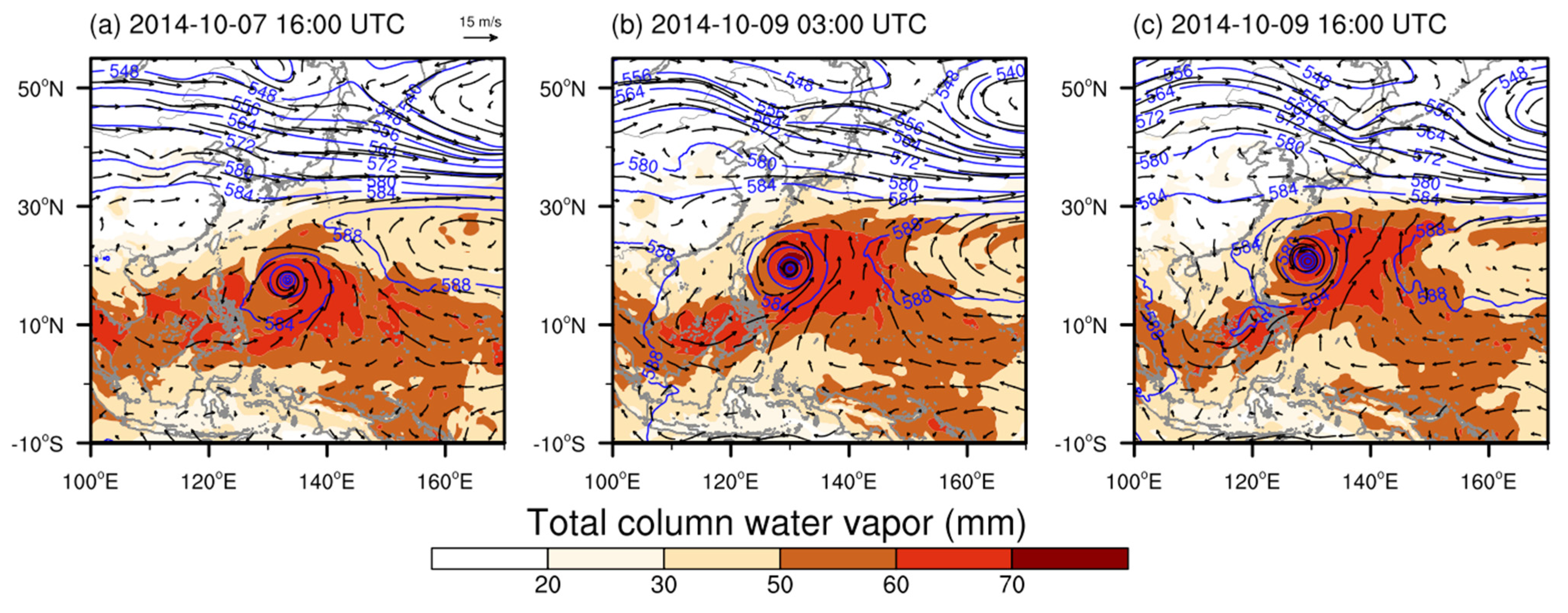
This study selected Typhoon Vongfong (2014) over the western North Pacific as a representative case that exhibited a sharp turn. Vongfong originated from a tropical disturbance over the western North Pacific in early October 2014 and gradually intensified as it continuously extracted heat and moisture from the ocean (Figure 1a). On the afternoon of 7 October, Vongfong reached its peak intensity, with a maximum sustained wind speed of 155 kt (Figure 1b). Subsequently, the TC made an abrupt turn, eventually making landfall in Japan (Figure 1a). During Vongfong’s sharp turning stage, the GPM satellite captured observations at three key times: 16:18 UTC on 7 October, 02:49 UTC on 9 October, and 16:07 UTC on 9 October. Although the TC slightly weakened during the turning period, it remained in the super typhoon intensity category at all three observation times. Importantly, the GPM successfully captured most of the TC’s core structure, providing valuable data for analyzing the precipitation evolution associated with Vongfong’s sharp turn.
To understand the sudden-turning process of Typhoon Vongfong, Figure 2 illustrates the large-scale circulation patterns during this period. Before the turning, Vongfong was located to the southwest of the WPSH and was guided northwestward by the easterly steering flow, while the southwesterly flow continuously supplied abundant moisture (Figure 2a). Subsequently, the WPSH weakened and retreated eastward, and Vongfong began to move northward (Figure 2b). As the WPSH weakened considerably and was displaced far to the east, it no longer dominated the typhoon’s track, and Vongfong continued moving northward (Figure 2c), indicating that the weakening and eastward retreat of the WPSH, together with changes in the steering flow, were key factors controlling Vongfong’s sharp northward turn [30,31].
Previous studies have shown that when the WPSH weakens, external steering becomes less dominant, and typhoon motion is more strongly affected by internal dynamical and thermodynamic processes [32]. During this period, internal structural adjustments—particularly in precipitation and cloud microphysical processes—likely played a crucial role. Therefore, the following section uses GPM observations to analyze the evolution of precipitation structure and microphysical characteristics during the sudden turn of Typhoon Vongfong.

3.2. The Precipitation Characteristics of Typhoon Vongfong

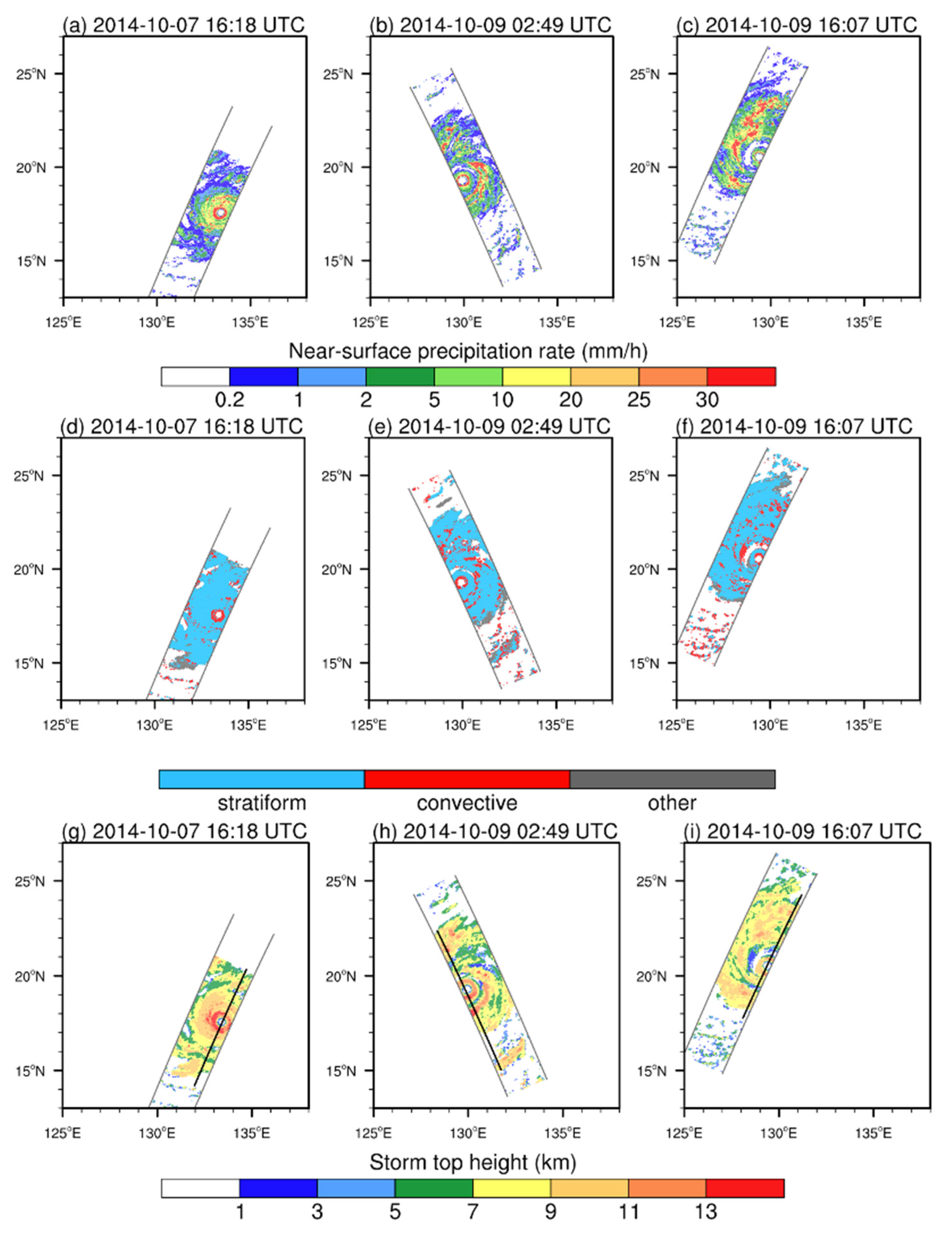
Based on the large-scale circulation background described above, the precipitation characteristics of Typhoon Vongfong are further examined throughout the period of its abrupt turning. Figure 3 illustrates the spatial distributions of near-surface precipitation rate, precipitation type, and cloud-top height, while Table 1 summarizes the sample size, average near-surface precipitation rate, LWP, IWP, PEI, and mean mass-weighted drop diameter (Dm) and number concentration (Nw) at 2 km altitude.
At 16:18 UTC on 7 October, before the sharp turn, GPM observed 5805 precipitation pixels, of which convective precipitation accounted for only 13% (Table 1). Compared with stratiform precipitation (4.37), convective precipitation (19.26) is stronger, with higher rain rate, larger IWP and LWP, higher PEI, larger Dm and more Nw (Table 1). Spatially, convective precipitation was primarily concentrated in the inner eyewall (Figure 3d), corresponding to regions with rain rate exceeding 30 mm h−1 (Figure 3a) and cloud-top heights above 13 km (Figure 3g). Stratiform precipitation, by contrast, dominated the outer eyewall and spiral rainbands (Figure 3c), with rain rate below 20 mm h−1 and cloud-top heights below 11 km.
At 02:49 UTC on 9 October, during the sharp turn, GPM observed 6199 pixels of precipitation, with the proportion of convective precipitation increasing to 22% (Table 1). As shown in Figure 3b,e,h, the precipitation area expanded, accompanied by a redistribution of convective precipitation from the inner eyewall to the spiral rainbands. However, the intensity of convective precipitation weakened (17.17 mm h−1), consistent with the decrease in LWP and IWP for convective precipitation, whereas stratiform precipitation (5.03 mm h−1) intensified, corresponding to the increase in LWP for stratiform precipitation. (Table 1).
By 16:07 UTC on 9 October, as Vongfong moved further northward, GPM observed 7079 precipitation pixels, indicating a continued expansion of the precipitation coverage. At this stage, convective precipitation accounted for 21% of the total, with a spatial pattern characterized by a reduction in convective precipitation within the inner eyewall and an increase in convective precipitation across the outer eyewall and spiral rainbands (Figure 3c,f,i). The precipitation rate of convective precipitation further decreased, while that of stratiform precipitation continued to increase (Table 1). Notably, precipitation efficiency increased for both convective and stratiform precipitation, consistent with the increase in Nw.
These highlight that during the sudden turn of Typhoon Vongfong, the precipitation coverage expanded, while convective precipitation shifted from being concentrated in the inner eyewall to extending into the outer eyewall and spiral rainbands, accompanied by a weakening in the rain rate of convective precipitation likely associated with the weakening of the typhoon (Figure 1b). Moreover, the precipitation efficiency of both convective and stratiform precipitation increased, closely related to the increase in Nw.
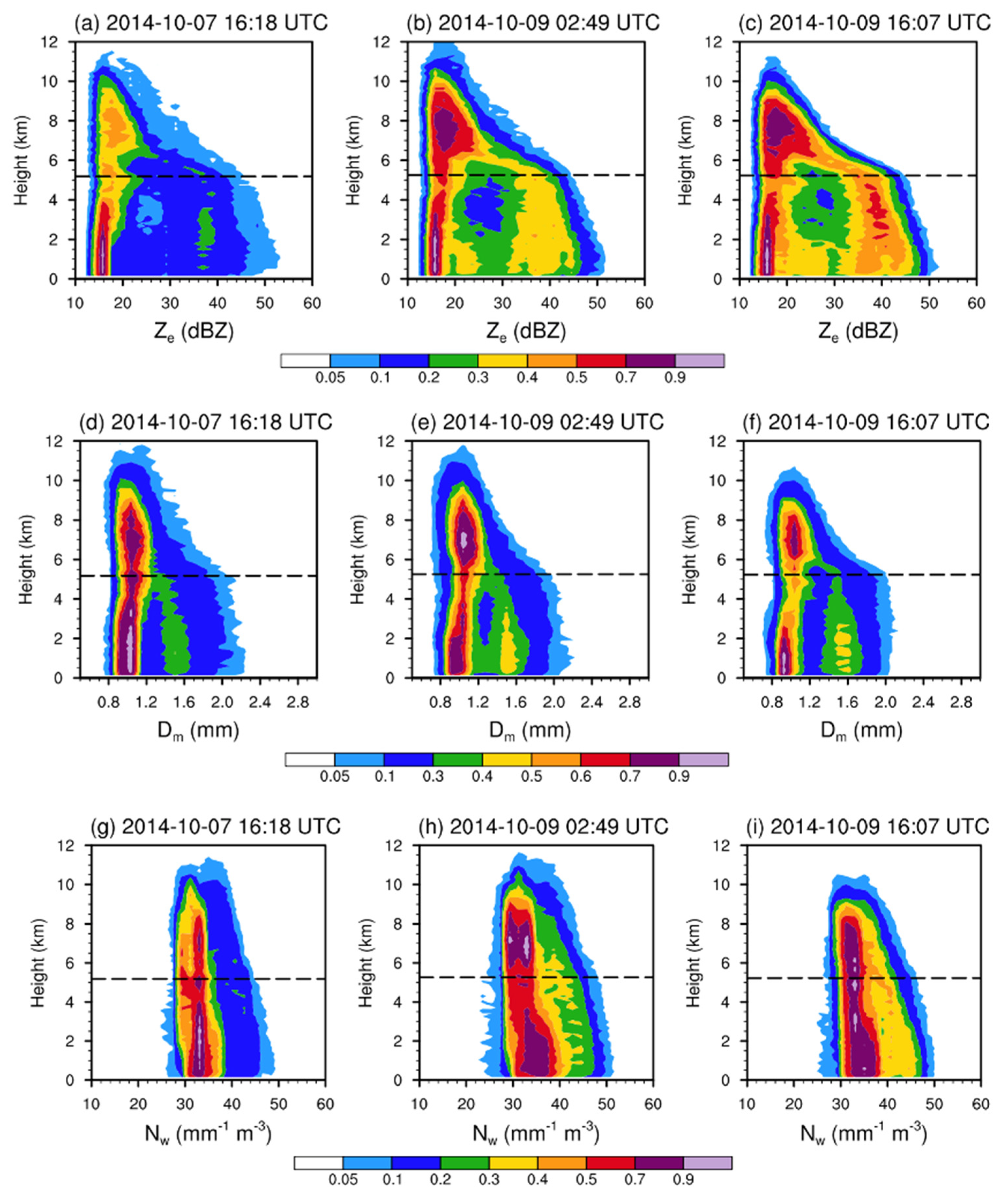
Figure 4 further illustrates the vertical cross sections of precipitation microphysical properties along the typhoon eye, revealing a distinct structural evolution during its sharp turn. At 16:18 UTC on 7 October (Figure 4a,d,g), Ze in the inner eyewall exceeded 42 dBZ, corresponding to convective precipitation regions (Figure 3d), while the outer eyewall and spiral rainbands exhibited weaker reflectivity with a melting layer bright band, corresponding to stratiform precipitation regions (Figure 3d). The Dm in the inner eyewall was similar to that in the outer eyewall and spiral rainbands, approximately 1.8–2.0 mm. However, the Nw in the inner eyewall exceeded 36 mm−1 m−3, significantly higher than the 33 mm−1 m−3 observed in the outer eyewall and spiral rainbands. Before turning, the typhoon reaches its peak intensity, in which its structure becomes more concentrated (Figure 1b), and the elevated cloud-top heights in the inner eyewall reflects the presence of strong updrafts (Figure 3g). The strong radar echoes in the eye of the typhoon corresponding to the particles have a high number concentration and a small radius, suggesting that the particles are undergoing a strong activation process but have not yet experienced sufficient collision and coalescence growth (Figure 4) [25,26].
During the sharp turn (Figure 4b,e,h), Ze in the inner eyewall weakened, whereas reflectivity in the outer eyewall and spiral rainbands increased. Dm and Nw exhibited similar variations, suggesting that both the Dm and Nw decreased within the eyewall, whereas they increased in the outer eyewall and spiral rainbands. By 16:07 UTC on 9 October (Figure 4c,f,i), inner eyewall reflectivity further weakened, accompanied by decreases in both Dm and Nw. During the turning process, the typhoon intensity weakens (Figure 1b), the typhoon structure disperses. The significantly lowered cloud-top heights (Figure 3h,i) indicated weakened updrafts in the eyewall. At this time, the particle radius increases while the number concentration decreases, indicating that particle collision and coalescence are strengthened (Figure 4).
Nolan et al. [33] indicate that the mass and condensate sources of TC’s outflow are primarily derived from the upward mass flux within the cyclone. Before the turning stage, strong upward motion supports concentrated deep convection in the inner core rather than promote outward cloud expansion, which is consistent with the compact structure of Vongfong prior to turning. As the typhoon begins to weaken during the turning stage, the reduction in deep upward mass flux suppresses the vertical development of deep convection, leading to decreases in Ze, Dm, and Nw within the eyewall (Figure 4). In contrast, enhanced low- to mid-level moisture inflow in the outer-core region favors the development of shallow and stratiform precipitation, which explains the increases in reflectivity and microphysical parameters in the outer eyewall and spiral rainbands. Once deep convective cloud cover diminishes, the increased anvil extent allows stronger longwave radiative cooling near cloud tops (Figure 3), which decreases the deep convection buoyancy and promotes the shallow convection and stratiform [34]. Such radiative–dynamical adjustments provide a plausible explanation for the opposite tendencies in deep and shallow convection during the turning stage. Thus, the opposite changes in convective and stratiform precipitation are governed by dynamical (vertical mass flux) and thermodynamic (radiative) feedbacks.
Overall, due to the eastward retreat of the WPSH, the sudden turn of typhoon track led to a shift in precipitation structure from being concentrated within the inner eyewall to being distributed across the outer eyewall and spiral rainbands. This transition was accompanied by a distinct change in microphysical process, characterized by reduced Dm and Nw in the inner eyewall and enhanced Dm and Nw in the outer rainbands—an “inner decrease and outer increase” pattern. This indicates that the precipitation microphysical processes were dominated by particle activation before the turning, whereas collision–coalescence processes became more intense during the turning stage.
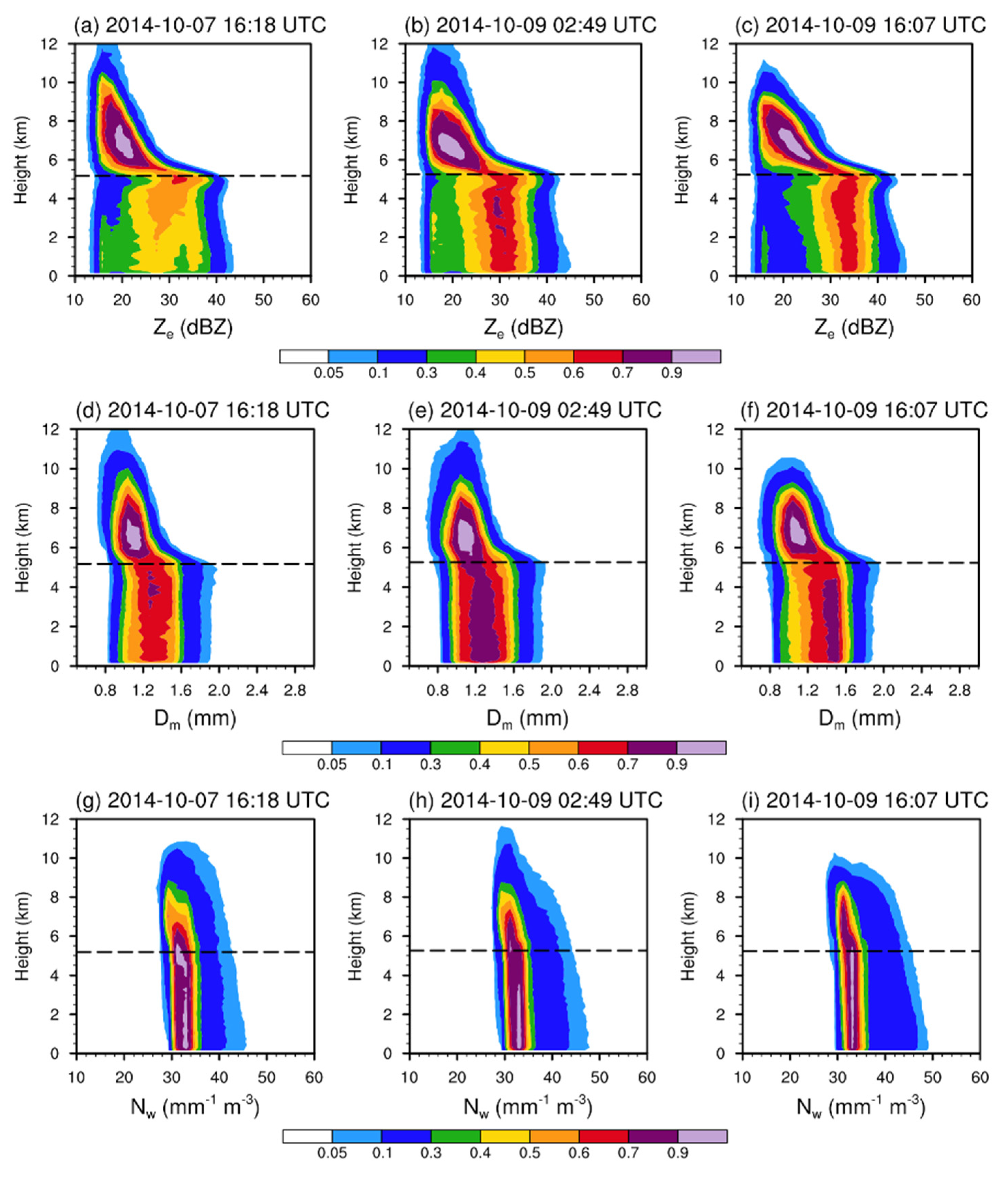
Figure 5 shows contoured frequency by altitude diagrams (CFADs) of stratiform precipitation microphysical parameters to further examine the evolution of precipitation microphysical characteristics during the sudden turn of Typhoon Vongfong.
At 16:18 UTC on 7 October (Figure 5a,d,g), stratiform Ze was primarily concentrated between 12 and 18 dBZ, with precipitation heights distributed mainly from the surface to 12 km. Correspondingly, with Dm concentrated between 0.8 and 1.2 mm, and Nw between 30 and 38 mm−1 m−3, it indicates relatively weak stratiform precipitation with smaller Dm and lower Nw.
At 02:49 UTC on 9 October (Figure 5b,e,h), Ze above the melting layer remained within 10–28 dBZ, similar to the pre-turning distribution (Figure 5a), but with notably higher occurrence frequencies, suggesting enhanced ice-phase processes in stratiform precipitation. Below the melting layer, Ze exhibited a distinct bimodal distribution, with significantly increased frequencies of 30–40 dBZ. This enhancement corresponded to higher frequencies of Dm exceeding 1.4 mm and Nw greater than 38 mm−1 m−3, indicating a pronounced intensification of stratiform precipitation during the track change.
By 16:07 UTC on 9 October (Figure 5c,f,i), the occurrence frequency of reflectivity exceeding 30 dBZ further increased, associated with higher frequencies of Nw above 38 mm−1 m−3. These results suggested a continued strengthening of stratiform precipitation, primarily reflected in the increase in Nw.
Overall, the analysis suggests that stratiform precipitation was significantly enhanced during the sudden turn of the typhoon. This enhancement was mainly characterized by a substantial increase in liquid-phase particle concentrations below the melting layer, pointing to an intensification of the warm-rain process in stratiform precipitation during the turning.
Figure 6 presents CFADs of convective precipitation microphysical properties to further investigate the evolution of convective precipitation during the sharp turn. At 16:18 UTC on 7 October (Figure 6a,d,g), convective precipitation exhibited higher Ze, larger Dm, and higher Nw compared with stratiform precipitation (Figure 5a,d,g), along with cloud-top heights exceeding 12 km. These features are consistent with previous findings that the eyewalls of super typhoons are typically composed of deep convective clouds with considerable thickness [24,25].
At 02:49 UTC on 9 October, during the sharp turn (Figure 6b,e,h), Ze, Dm, and Nw above 9 km were reduced, indicating a weakening of the vertical development of convective precipitation, which was likely associated with weakened updrafts resulting from the reduction in typhoon intensity.
By 16:07 UTC on 9 October (Figure 6c,f,i), the cloud-top height of convective precipitation further decreased to approximately 11 km, accompanied by a continuous decrease in Ze above the melting layer. These results demonstrate a continued weakening of convective precipitation, manifested in the reduced vertical extent of convection and weakened ice-phase processes.
To understand the possible reasons for changes in precipitation microphysical characteristics during the typhoon’s sharp turn, Figure 7 shows the probability distributions of the cloud water path and cloud ice path during this period. At 16:18 UTC on 7 October, before the turn (Figure 7a,d), the relationship between LWP and IWP was approximately linear for stratiform precipitation, with higher LWP values corresponding to higher IWP values. Compared with stratiform precipitation, convective precipitation shows a much larger LWP than IWP, indicating stronger warm-rain processes. At 02:49 UTC on 9 October, (Figure 7b,e), the LWP range in stratiform precipitation increased, while the IWP range changed slightly, indicating an increase in the warm-rain process in stratiform precipitation. The LWP range in convective precipitation changed slightly, while the IWP range decreased, indicating a weakening of the ice-phase process in convective precipitation. At 16:07 UTC on 9 October, the warm-rain process in stratiform precipitation continued to increase, while the ice-phase in convective precipitation weakened further. During the sudden turn process of the typhoon, the enhancement of the warm-rain process led to the strengthening of stratiform precipitation, while the weakening of the ice-phase process resulted in the weakening of convective precipitation.
In order to better understand the physical processes of warm-rain process in convective precipitation and stratiform precipitation during the sudden turn, the differences in particle radius and Ze at 1 km and 3 km (ΔZe = Ze1 km − Ze3 km; ΔDm = Dm1 km − Dm3 km) were analyzed in similar previous studies [25]. The relationship between ΔDm with ΔZe can be divided into four quadrants. When ΔZe > 0 and ΔDm > 0 (the first quadrant), raindrops grow through collision–coalescence. When ΔZe < 0 and ΔDm > 0 (the second quadrant), the primary microphysical processes are evaporation and size sorting. When ΔZe < 0 and ΔDm < 0 (the third quadrant), larger raindrops break into smaller ones. When ΔZe > 0 and ΔDm < 0 (the fourth quadrant), the collision and breakup processes are in balance.
Figure 8 shows the probability distributions of ΔDm and ΔZe in convective and stratiform precipitation. Collision–coalescence processes contributed significantly to convective precipitation, while breakup and collision processes dominated in stratiform precipitation. With the sudden change in moving direction, the collision process in stratiform precipitation increased, while the breakup process decreased (Figure 8a–c), consistent with changes in LWP (Figure 7b). This suggests that increased LWP favors the collision–coalescence of stratiform precipitation particles, leading to an increase in the radius of Dm. For the convective precipitation, the collision–coalescence process changed from 63.7% to 73.9% from 16:18 UTC on 7 October to 02:49 UTC on 9 October (Figure 8d,e). Then, the collision process changed from 73.9% to 69.9% (Figure 8e,f). This suggests that when sudden track change occurs to the typhoon, the collision process experiences a sudden increase, followed by a decrease. The change in collision–coalescence process was not consistent with the change in convective precipitation rate, indicating that convective precipitation not only depends on the warm-rain process, but also relies on the ice-phase process.

4. Discussion

Due to most of the sudden-turning typhoons occurring over the open ocean, where ground-based radars are unavailable, GPM is one of the few platforms capable of capturing the high-resolution vertical profiles of microphysical structure in such events. Typhoon Vongfong was selected because it is a typical sudden-turning typhoon and, importantly, GPM DPR captured three key stages of its turning evolution while the TC maintained super-typhoon intensity. This makes Vongfong a valuable and representative case for examining the microphysical processes during a sudden turn. This finding provides useful insights for improving model development.
However, as a single-case study based on polar-orbiting satellite observations, this work has limitations. The microphysical evolution observed here may be modulated by TC intensity, environmental moisture, and synoptic conditions, and caution should be exercised when generalizing these findings to other turning typhoons. In future work, we will use numerical simulations of Typhoon Vongfong to evaluate and refine cloud microphysics parameterizations in the model, and further analyze opposite signs of stratiform and convective precipitation based on evaluating the detailed thermodynamic and dynamical budgets by using better schemes. Because turning typhoons differ in intensity and circulation, future work will employ composite analysis to analyze how microphysical processes evolve during turning events under different TC intensities and synoptic backgrounds.

5. Conclusions

In this study, continuous GPM observations of Super Typhoon Vongfong (2014) were utilized to analyze the evolution of precipitation structure and microphysical characteristics during the sharp turn. The main conclusions are as follows:
  • The sudden turn of Super Typhoon Vongfong (2014) occurred during the eastward retreat of the WPSH. Before the sharp turn, the typhoon reached its peak intensity with the lowest central pressure and the highest wind speed. Its structure was highly organized with strong and concentrated upward motion within the eyewall. During the sharp turn, the typhoon weakened, the upward motion in the eyewall decreased, and the TC structure became more dispersed.
  • The spatial distribution and intensity of precipitation changed significantly during the sudden turn of a typhoon. Before the sharp turn, convective precipitation was concentrated in the eyewall, with an average rate of 19.26 mm h−1. During the sudden change in moving direction, the precipitation area expanded, and the distribution of convective precipitation changed from the inner eyewall to the outer eyewall and spiral rainbands, with the average rate decreasing to 15.52 mm h−1. In contrast, stratiform precipitation increased from 4.37 mm h−1 to 7.70 mm h−1 during this period.
  • During the sharp turn, the vertical structure of precipitation and hydrometeor content underwent significant changes influenced by the weakening of the typhoon. Due to convective precipitation mainly developed around the eyewall, the weakened eyewall ascent reduced the height of convection precipitation, with the cloud-top height decreasing from 12 km to 11 km, accompanied by lower ice water content and weaker ice-phase processes, which led to a decrease in convective precipitation intensity. Stratiform precipitation mainly occurred outside the eyewall. The increased southwest moisture transport increased cloud water content (LWP), enhancing the occurrence probabilities of large raindrops and strengthening stratiform rainfall.

Author Contributions

Conceptualization, G.Y., J.C.-H.L. and W.D.; methodology, G.Y.; software, G.Y. and W.Z.; validation, G.Y., W.Z. and F.W.; formal analysis, G.Y., W.Z. and F.W.; investigation, G.Y.; resources, J.C.-H.L., W.D., and B.Z.; data curation, G.Y.; writing—original draft preparation, G.Y., W.Z. and F.W.; writing—review and editing, G.Y., W.Z., F.W., J.C.-H.L., W.D. and B.Z.; visualization, G.Y. and W.Z.; supervision, W.D., J.C.-H.L. and B.Z.; project administration, G.Y.; funding acquisition, W.D. and B.Z. All authors have read and agreed to the published version of the manuscript.

Funding

This research was funded by the project supported by Innovation Group Project of Southern Marine Science and Engineering Guangdong Laboratory (Zhuhai) (No. 311024009), the NUDT Research Initiation Funding for High-Level Scientific and Technological Innovative Talents (202402-YJRC-LJ-001), the National Natural Science Foundation of China (Grant No. U21A6001) and the project supported by the Southern Marine Science and Engineering Guangdong Laboratory (Zhuhai) (No. SML2024SP011), National Natural Science Foundation of China (42405038).

Data Availability Statement

The datasets used in this study are publicly available. GPM Dual-frequency Precipitation Radar (DPR) Level 2 data were obtained from NASA’s Goddard Earth Sciences Data and Information Services Center (GES DISC) at https://disc.gsfc.nasa.gov (accessed on 1 September 2025). Typhoon best track data were obtained from the International Best Track Archive for Climate Stewardship (IBTrACS) version 4 revision 1, available at https://www.ncei.noaa.gov/data/international-best-track-archive-for-climate-stewardship-ibtracs/v04r01 (accessed on 1 September 2025).

Acknowledgments

We thank for the technical support of the National Large Scientific and Technological Infrastructure “Earth System Numerical Simulation Facility” (https://cstr.cn/31134.02.EL).

Conflicts of Interest

The authors declare no conflicts of interest.

References

  1. Emanuel, K. Increasing destructiveness of tropical cyclones over the past 30 years. Nature 2005, 436, 686–688. [Google Scholar] [CrossRef] [PubMed]
  2. Jing, R.; Heft-Neal, S.; Chavas, D.R.; Griswold, M.; Wang, Z.; Clark-Ginsberg, A.; Guha-Sapir, D.; Bendavid, E.; Wagner, Z. Global population profile of tropical cyclone exposure from 2002 to 2019. Nature 2024, 626, 549–554. [Google Scholar] [CrossRef] [PubMed]
  3. Archambault, H.M.; Bosart, L.F.; Keyser, D.; Cordeira, J.M. A Climatological Analysis of the Extratropical Flow Response to Recurving Western North Pacific Tropical Cyclones. Mon. Weather Rev. 2013, 141, 2325–2346. [Google Scholar] [CrossRef]
  4. Li, Y.; Heming, J.; Torn, R.D.; Lai, S.; Xu, Y.; Chen, X. Unusual tracks: Statistical, controlling factors and model prediction. Trop. Cyclone Res. Rev. 2023, 12, 309–322. [Google Scholar] [CrossRef]
  5. Heming, J.T.; Prates, F.; Bender, M.A.; Bowyer, R.; Cangialosi, J.; Caroff, P.; Coleman, T.; Doyle, J.D.; Dube, A.; Faure, G.; et al. Review of Recent Progress in Tropical Cyclone Track Forecasting and Expression of Uncertainties. Trop. Cyclone Res. Rev. 2019, 8, 181–218. [Google Scholar] [CrossRef]
  6. Yu, H.; Chen, G.; Zhou, C.; Wong, W.K.; Yang, M.; Xu, Y.; Chen, P.; Wan, R.; Hu, X. Are We Reaching the Limit of Tropical Cyclone Track Predictability in the Western North Pacific? Bull. Am. Meteorol. Soc. 2022, 103, E410–E428. [Google Scholar] [CrossRef]
  7. The Weather Channel. Super Typhoon Vongfong Becomes Strongest Storm on Earth. 2014. Available online: https://weather.com/storms/hurricane/news/vongfong-satellite-images-strongest-storm-20141010 (accessed on 7 October 2025).
  8. Vinour, L.; Jullien, S.; Mouche, A.; Combot, C.; Mangeas, M. Observations of Tropical Cyclone Inner-Core Fine-Scale Structure, and Its Link to Intensity Variations. J. Atmos. Sci. 2021, 78, 3651–3671. [Google Scholar] [CrossRef]
  9. Wang, Z.; Yang, J.; Chen, F.; Liu, Y.; Shi, L. Characterizing the Macro and Micro Properties of Precipitation During the Landfall of Typhoon Lekima by Using GPM Observations. Remote Sens. 2024, 16, 2765. [Google Scholar] [CrossRef]
  10. Holbach, H.M.; Bousquet, O.; Bucci, L.; Chang, P.; Cione, J.; Ditchek, S.; Doyle, J.; Duvel, J.-P.; Elston, J.; Goni, G.; et al. Recent advancements in aircraft and in situ observations of tropical cyclones. Trop. Cyclone Res. Rev. 2023, 12, 81–99. [Google Scholar] [CrossRef]
  11. He, H.; Tian, R.; Lyu, X.; Ling, Z.; Sun, J.; Cao, A. Annual Review of In Situ Observations of Tropical Cyclone–Ocean Interaction in the Western North Pacific During 2023. Remote Sens. 2024, 16, 1990. [Google Scholar] [CrossRef]
  12. Lin, K.-J.; Yang, S.-C.; Chen, S.S. Improving Analysis and Prediction of Tropical Cyclones by Assimilating Radar and GNSS-R Wind Observations: Ensemble Data Assimilation and Observing System Simulation Experiments Using a Coupled Atmosphere–Ocean Model. Weather Forecast. 2022, 37, 1533–1552. [Google Scholar] [CrossRef]
  13. Huang, H.; Chen, F. Precipitation microphysics of tropical cyclones over the western North Pacific based on GPM DPR observations: A preliminary analysis. J. Geophys. Res. Atmos. 2019, 124, 3124–3142. [Google Scholar] [CrossRef]
  14. Huang, X.; Wu, Z.; Xie, Y.; Zhang, Y.; Zhang, L.; Zheng, H.; Xiao, W. Precipitation microphysics of locally-originated typhoons in the south China sea based on GPM satellite observations. Remote Sens. 2023, 15, 2657. [Google Scholar] [CrossRef]
  15. Wu, Z.; Huang, Y.; Zhang, Y.; Zhang, L.; Lei, H.; Zheng, H. Precipitation characteristics of typhoon Lekima (2019) at landfall revealed by joint observations from GPM satellite and S-band radar. Atmos. Res. 2021, 260, 105714. [Google Scholar] [CrossRef]
  16. Hou, A.Y.; Kakar, R.K.; Neeck, S.; Azarbarzin, A.A.; Kummerow, C.D.; Kojima, M.; Oki, R.; Nakamura, K.; Iguchi, T. The Global Precipitation Measurement Mission. Bull. Am. Meteorol. Soc. 2014, 95, 701–722. [Google Scholar] [CrossRef]
  17. Skofronick-Jackson, G.; Petersen, W.A.; Berg, W.; Kidd, C.; Stocker, E.F.; Kirschbaum, D.B.; Kakar, R.; Braun, S.A.; Huffman, G.J.; Iguchi, T.; et al. The Global Precipitation Measurement (GPM) mission for science and society. Bull. Am. Meteorol. Soc. 2017, 98, 1679–1695. [Google Scholar] [CrossRef]
  18. Skofronick-Jackson, G.; Kirschbaum, D.; Petersen, W.; Huffman, G.; Kidd, C.; Stocker, E.; Kakar, R. The Global Precipitation Measurement (GPM) mission’s scientific achievements and societal contributions: Reviewing four years of advanced rain and snow observations. Q. J. R. Meteorol. Soc. 2018, 144, 27–48. [Google Scholar] [CrossRef]
  19. Iguchi, T.; Seto, S.; Meneghini, R.; Yoshida, N.; Awaka, J.; Le, M.; Chandrasekar, V.; Brodzik, S.; Kubota, T. GPM/DPR Level-2 Algorithm Theoretical Basis Document. NASA Goddard Space Flight Center. 2010. Available online: https://gpm.nasa.gov/resources/documents/gpm-dpr-level-2-algorithm-theoretical-basis-document-atbd (accessed on 1 September 2025).
  20. Yang, B.; Ren, S.; Wang, X.; Niu, N. Precipitation Characteristics at Different Developmental Stages of the Tibetan Plateau Vortex in July 2021 Based on GPM-DPR Data. Remote Sens. 2024, 16, 1947. [Google Scholar] [CrossRef]
  21. Zhang, W.; Ye, G.; Leung, J.C.-H.; Zhang, B. Microphysical Characteristics of Summer Precipitation over the Taklamakan Desert Based on GPM-DPR Data from 2014 to 2023. Atmosphere 2025, 16, 354. [Google Scholar] [CrossRef]
  22. Qi, W.; Yong, B.; Gourley, J.J. Monitoring the super typhoon Lekima by GPM-based near-real-time satellite precipitation estimates. J. Hydrol. 2021, 603, 126968. [Google Scholar] [CrossRef]
  23. Wang, Y.; Xia, B.; Chen, Y.; Chen, H.; Xie, J. Revisiting the Characteristics of Super Typhoon Saola (2023) Using GPM, Himawari-9 and FY-4B Satellite Data. Atmosphere 2024, 15, 290. [Google Scholar] [CrossRef]
  24. Kumar, K.S.; Das, S.K.; Deshpande, S.M.; Deshpande, M.; Pandithurai, G. Regional variability of precipitation characteristics in tropical cyclones over the North Indian Ocean from GPM-DPR measurements. Atmos. Res. 2023, 283, 106568. [Google Scholar] [CrossRef]
  25. Kumar, A.; Srivastava, A.K.; Sunilkumar, K.; Srivastava, M.K. Microphysical Characteristics of Cyclonic Rainfall: A GPM-DPR Based Study Over the Arabian Sea. Earth Space Sci. 2023, 10, e2023EA002895. [Google Scholar] [CrossRef]
  26. Cannon, F.; Ralph, F.M.; Wilson, A.M.; Lettenmaier, D.P. GPM satellite radar measurements of precipitation and freezing level in atmospheric rivers: Comparison with ground-based radars and reanalyses. J. Geophys. Res. Atmos. 2017, 122, 12747–12764. [Google Scholar] [CrossRef]
  27. Choi, S.; Ryu, J.; Lee, S.; Sohn, B. Characteristics of global light rain system from GPM/DPR measurements. J. Geophys. Res. Atmos. 2025, 130, e2024JD042434. [Google Scholar] [CrossRef]
  28. Knapp, K.R.; Kruk, M.C.; Levinson, D.H.; Diamond, H.J.; Neumann, C.J. The International Best Track Archive for Climate Stewardship (IBTrACS): Unifying tropical cyclone best track data. Bull. Am. Meteorol. Soc. 2010, 91, 363–376. [Google Scholar] [CrossRef]
  29. Gahtan, J.; Knapp, R.; Schreck, C.J.; Diamond, H.J.; Kossin, J.P.; Kruk, M.C. International Best Track Archive for Climate Stewardship (IBTrACS) Project, Version 4r01. NOAA National Centers for Environmental Information. 2024. Available online: https://www.ncei.noaa.gov/access/metadata/landing-page/bin/iso?id=gov.noaa.ncdc:C01552 (accessed on 1 September 2025).
  30. Wu, L.; Zong, H.; Liang, J. Observational Analysis of Sudden Tropical Cyclone Track Changes in the Vicinity of the East China Sea. J. Atmos. Sci. 2011, 68, 3012–3031. [Google Scholar] [CrossRef]
  31. Shi, W.; Fei, J.; Huang, X.; Cheng, X.; Ding, J.; He, Y. A numerical study on the combined effect of midlatitude and low-latitude systems on the abrupt track deflection of Typhoon Megi (2010). Mon. Weather. Rev. 2014, 142, 2483–2501. [Google Scholar] [CrossRef]
  32. Park, J.; Cha, D.; Lee, M.K.; Moon, J.; Hahm, S.; Noh, K.; Chan, J.C.L.; Bell, M. Impact of cloud microphysics schemes on tropical cyclone forecast over the western North Pacific. J. Geophys. Res. Atmos. 2020, 125, e2019JD032288. [Google Scholar] [CrossRef]
  33. Nolan, D.S.; Fischer, M.S.; O’Neill, M.E. Reconsideration of the Mass and Condensate Sources for the Tropical Cyclone Outflow. Bull. Am. Meteorol. Soc. 2025, 106, E1342–E1359. [Google Scholar] [CrossRef]
  34. Xu, H.; Zhang, D. Impacts of cloud radiative processes on the convective and stratiform rainfall associated with Typhoon Fitow (2013). Front. Earth Sci. 2022, 16, 1052–1060. [Google Scholar] [CrossRef]
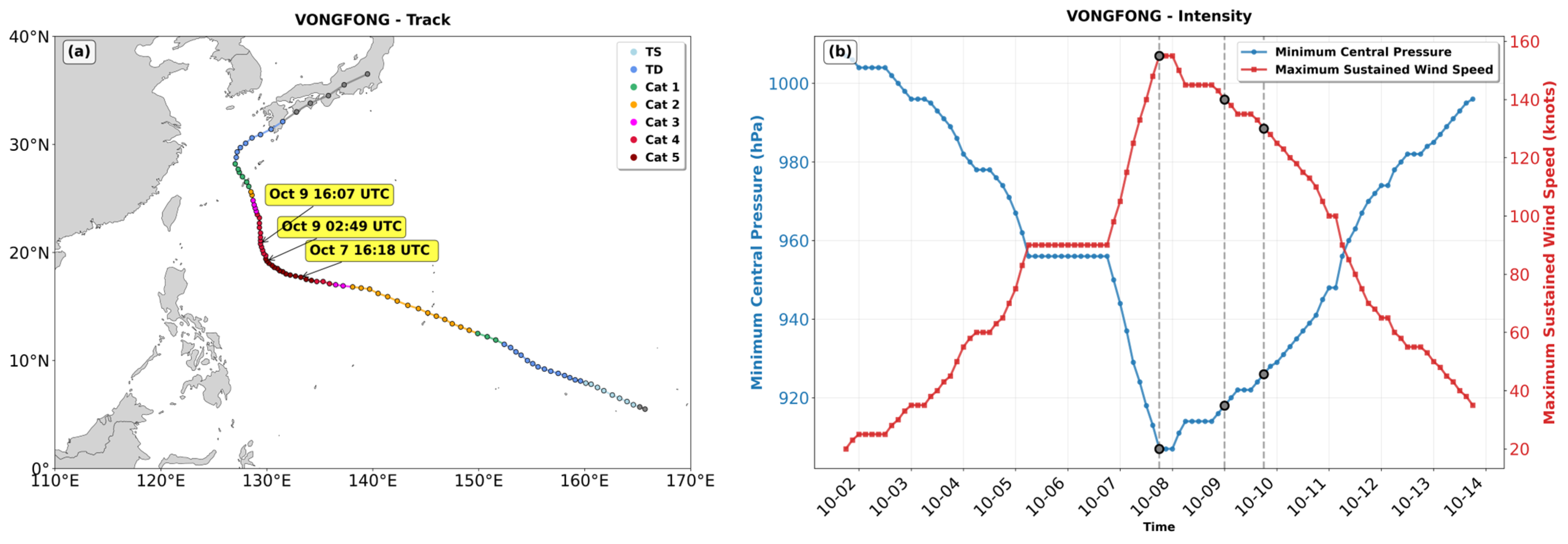
Figure 1. Best track and intensity evolution of Typhoon Vongfong (October 2014). (a) Best track of Typhoon Vongfong from the IBTrACS. The yellow box indicates the time scanned by the GPM. (b) Evolution of the maximum sustained wind speed (red solid line, kt) and minimum central pressure (blue solid line, hPa). The gray dots and dotted lines represent the time of typhoon observation and the location of the overpass scanned by the GPM.
Remotesensing 17 03984 g001
Figure 2. Large-scale circulation associated with Typhoon Vongfong during the sharp turn. Geopotential height of 500 hPa (blue contours, gpm), 500 hPa wind vectors (m s−1), and total column water vapor (shading, mm) at (a) 16:00 UTC on 7 October, (b) 03:00 UTC on 9 October, and (c) 16:00 UTC on 9 October 2014 from the European Center for Medium-Range Weather Forecasts (ECMWF) a −mospheric reanalysis (ERA5).
Remotesensing 17 03984 g002
Figure 3. Horizontal characteristics of Vongfong during the sharp turn. (ac) The near-surface precipitation rate (mm·h−1), (df) precipitation type, and (gi) cloud-top height (km). (a,d,g) 16:18 UTC on 7 October, (b,e,h) 02:49 UTC on 9 October, (c,f,i) 16:07 UTC on 9 October.
Remotesensing 17 03984 g003
Figure 4. Vertical cross sections of cloud microphysics in Vongfong during the sharp turn. (ac) Ze (dBZ), (df) Dm (mm), and (gi) Nw (mm−1·m−3) along the black solid lines in Figure 3a–c. Panels correspond to (a,d,g) 16:18 UTC on 7 October, (b,e,h) 02:49 UTC on 9 October, and (c,f,i) 16:07 UTC on 9 October 2014. A nine–point spatial smoothing was applied to reduce noise and improve the visualization of the patterns.
Remotesensing 17 03984 g004
Figure 5. CFAD of stratiform cloud microphysics in Vongfong during the sharp turn. (ac) Ze (dBZ), (df) Dm (mm), and (gi) Nw (mm−1 m−3). Panels correspond to (a,d,g) 16:18 UTC on 7 October, (b,e,h) 02:49 UTC on 9 October, and (c,f,i) 16:07 UTC on 9 October 2014. The black dashed line indicates the melting layer height.
Remotesensing 17 03984 g005
Figure 6. Same as Figure 5, but for convective precipitation.
Remotesensing 17 03984 g006
Figure 7. Probability distributions of LWP and IWP in Vongfong during the sharp turn. (ac) Stratiform precipitation, and (df) convective precipitation. (a,d) At 16:18 UTC on 7 October, (b,e) 02:49 UTC on 9 October, and (c,f) 16:07 UTC on 9 October.
Remotesensing 17 03984 g007
Figure 8. Two-dimensional frequency distribution of ΔDm (unit: mm) and ΔZe (unit: dBZ) in Vongfong during the sharp turn. (ac) Stratiform precipitation, and (df) convective precipitation. (a,d) At 16:18 UTC on 7 October, (b,e) 02:49 UTC on 9 October, and (c,f) 16:07 UTC on 9 October.
Remotesensing 17 03984 g008
Table 1. The sample number, mean near-surface rain rate, LWP, IWP, PEI, Dm, and Nw at 2 km in Vongfong during the sharp turn.
7 October 2014 16:189 October 2014 02:499 October 2014 16:07
Rain TypesStratiformConvectiveStratiformConvectiveStratiformConvective
No. of samples50237824834136556101469
Rain rate (mm/h)4.3719.265.0317.177.7015.52
LWP (g m−2)960.543532.391090.473028.291608.732768.58
IWP (g m−2)421.46492.31379.63307.47535.70256.01
PEI (h−1)2.534.462.875.072.955.26
Dm (mm)1.321.461.331.381.351.40
Nw (mm−1m−3)34.2836.5334.9437.5736.2737.69
Disclaimer/Publisher’s Note: The statements, opinions and data contained in all publications are solely those of the individual author(s) and contributor(s) and not of MDPI and/or the editor(s). MDPI and/or the editor(s) disclaim responsibility for any injury to people or property resulting from any ideas, methods, instructions or products referred to in the content.