Next-Generation C-Band SAR Mission: Design Concept for Earth Observation Service Continuity
Highlights
- The study identified and evaluated two design configurations for a next-generation Canadian C-band SAR mission: (i) a three-medium-satellite constellation and (ii) a five-large-satellite system meeting user needs and demonstrating technical and programmatic feasibility, balancing performance based on innovative capabilities, cost, and minimizing risk.
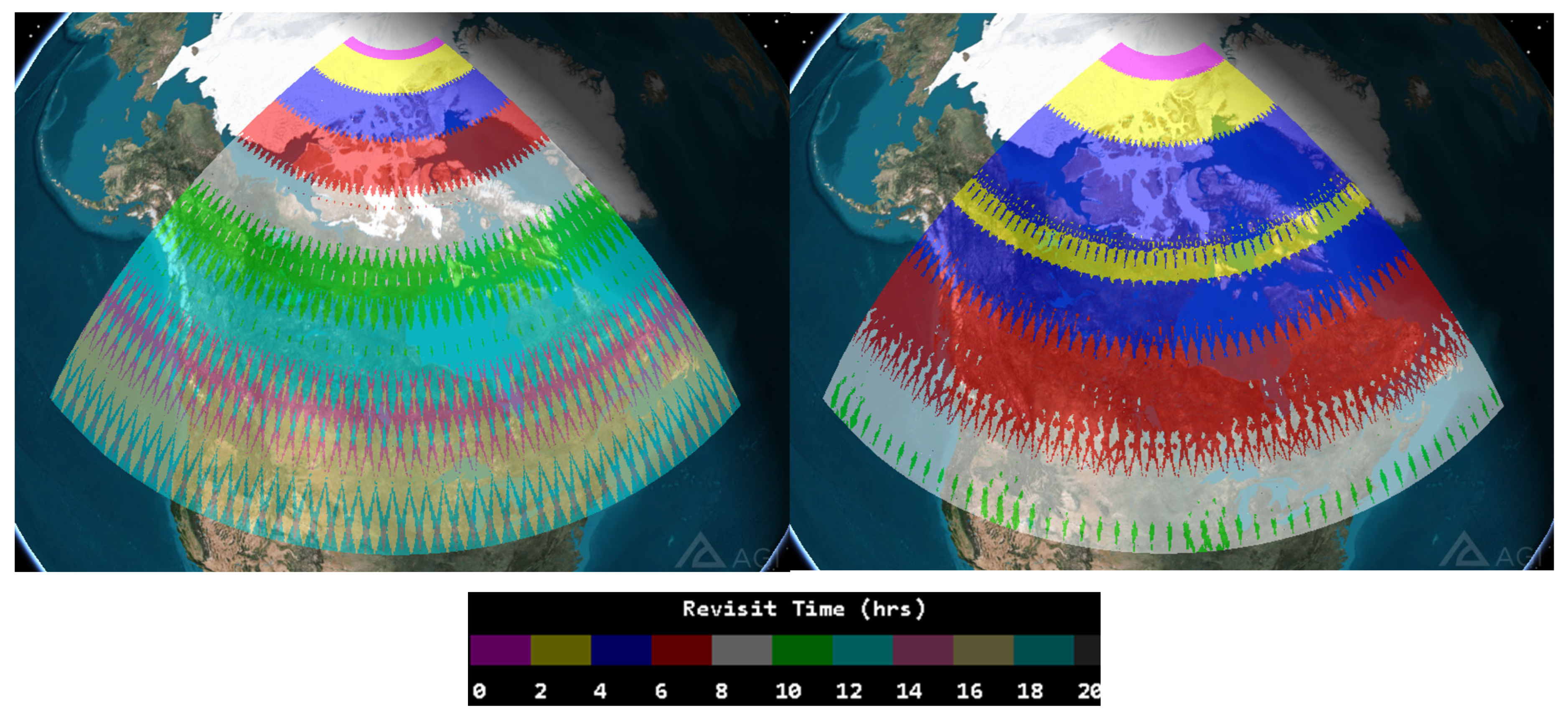
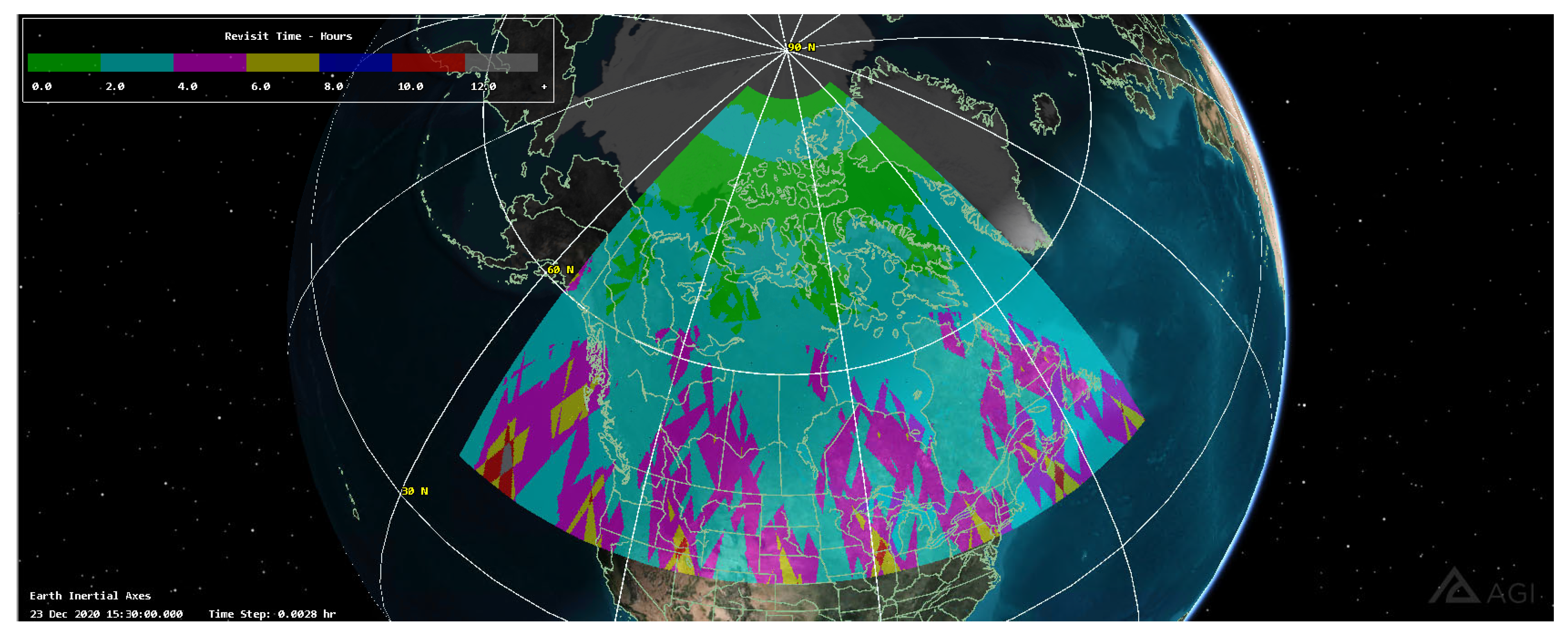
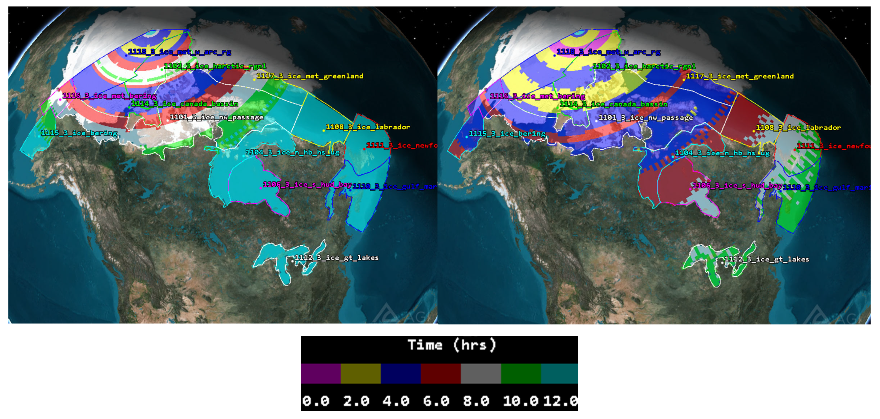
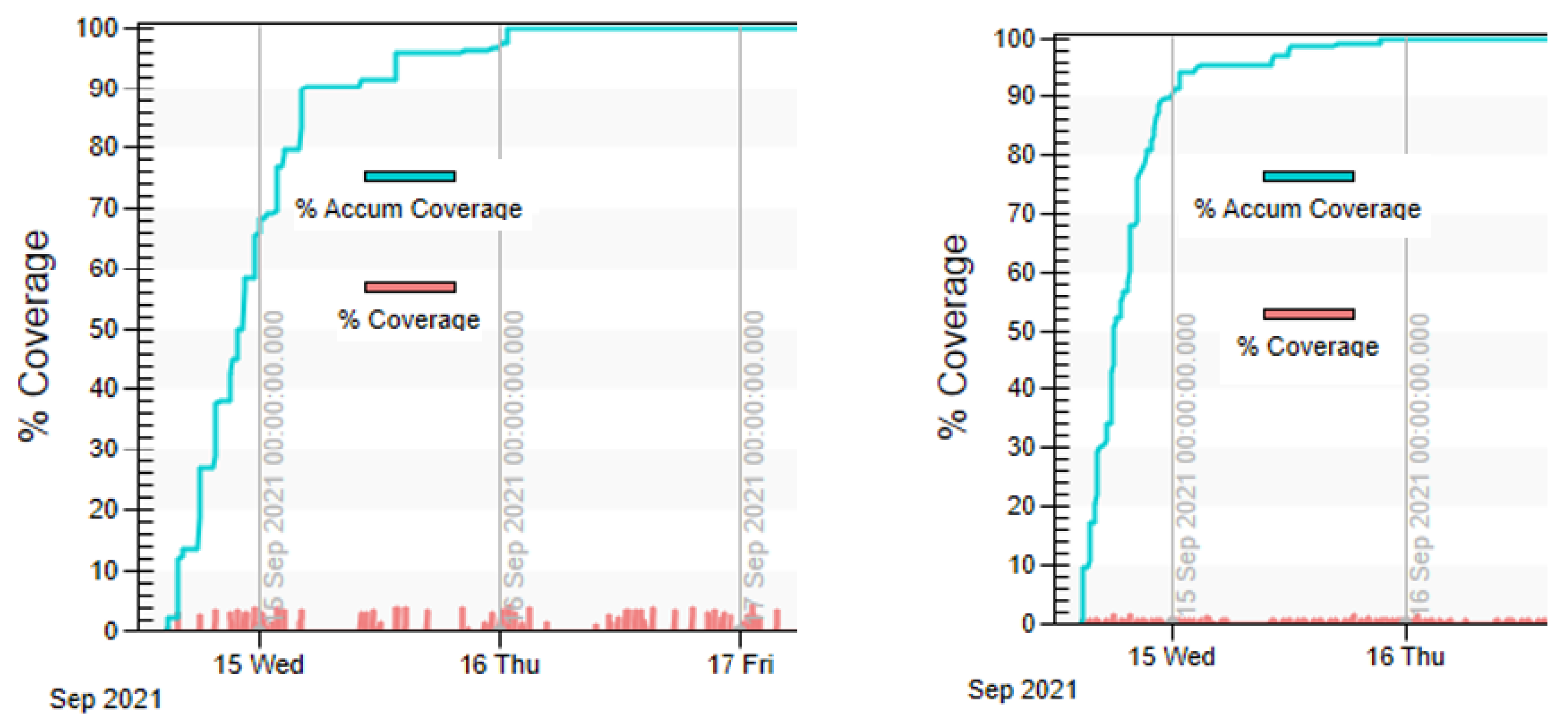
- Performance simulations confirmed that high-resolution, wide-swath imaging with full polarimetric capabilities can achieve revisit times below six hours over Canadian areas of interest, ensuring continuity of Canadian EO services for environmental monitoring, maritime surveillance, and national security applications.
- The systematic analysis of harmonized user needs represents a methodological advance, highlighting the necessity of scalable architectures, cost modelling, and coordinated planning for long-term EO service delivery.
- The proposed SAR mission architecture provides a strategic pathway for Canada’s EO continuity until 2050 and beyond, supporting adaptive mission scaling and facilitating integration of future satellite technologies.
Abstract
1. Introduction
1.1. SAR Satellite Missions
- Envisat satellite (2002) had 10 instruments together, including the ASAR (Advanced Synthetic Aperture Radar), which ensured long-term continuity of data after ERS-2 with enhanced capability in terms of coverage, range of incidence angles, polarization, and modes of operation [24];
- TanDEM-X and TerraSAR-X satellite formation achieved their primary objectives in the generation of a global Digital Elevation Model (DEM) with high (2 m) accuracy and proved concepts [27] for a wide range of commercial and scientific applications with its unique capabilities, including along-track interferometry and new bistatic and multistatic SAR techniques [28].
- COSMO-SkyMed and COSMO-SkyMed Seconda Generazione (CSG) satellites provide outstanding characteristics in terms of temporal, spatial, and radiometric resolution for both civilian and military applications [29]. For example, each CSG satellite is capable of simultaneously acquiring two images in DI2S Spotlight Multi-Swath (MS) mode [30] to serve two requests.
- The Advanced Land Observing Satellites (ALOS) series evolved from ALOS-1 (Daichi), launched in 2006 with an L-band SAR sensor PALSAR, to ALOS-2, launched in 2014, with enhanced SAR capabilities, improved resolution, and a wider observation swath [31]. The ALOS-4, launched in 2024, advances these capabilities with a next-generation phased-array L-band SAR [32], enabling higher-resolution and more frequent Earth observations for applications such as disaster monitoring and environmental studies.
- Sentinel-1: systematic global acquisition allowing the generation of different applications and value-added products from the same data take [33]. Its open data policy further promotes and supports both operational services and scientific research.
- The RADARSAT Constellation Mission (RCM) is a Canadian three-C-band SAR satellite system that provides enhanced coverage, higher revisit rates for 4-day InSAR revisit, and compact polarimetric applications.
- NovaSAR is a small SAR satellite operating in the S-band with optimized imaging modes for various environmental and security needs to support various applications such as maritime surveillance, flood monitoring, and disaster response.
- HISEA-1 C-band SAR microsatellite [34] introduced innovation in ocean and coastal remote sensing with high-resolution and high-revisit imaging capabilities.
- Gaofen-3 (GF-3) is a Chinese C-band SAR satellite, launched in 2016, that operates in multi-polarization modes and provides a high-resolution imaging capability supporting a large number of applications [35].
- Argentinian SAOCOM mission with advanced L-band SAR capabilities demonstrated great achievements in improved agricultural monitoring, disaster management, and hydrological studies.
1.2. Advances in SAR Satellite Technologies
1.3. User Needs and Requirements
1.4. SAR Mission Conceptual Designs
2. Methods
2.1. User Needs Analysis
2.2. SAR Performance Analysis
2.3. Programmatic Analysis
2.3.1. Schedule Development Methodology
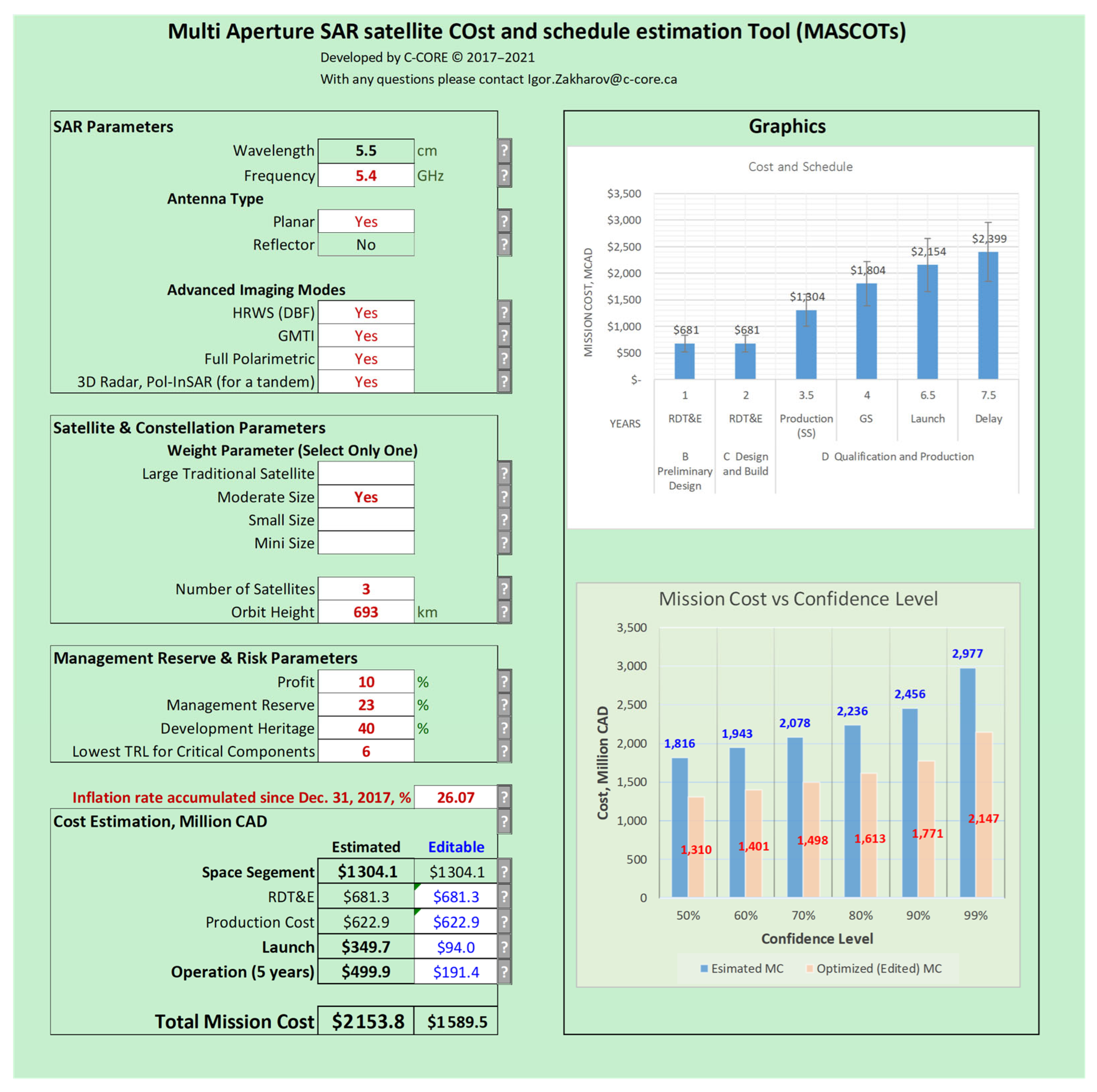
2.3.2. Cost Estimation
- -
- 90% for less than 10 units;
- -
- 80% for more than 10 units.
2.3.3. Risk Management
3. Results
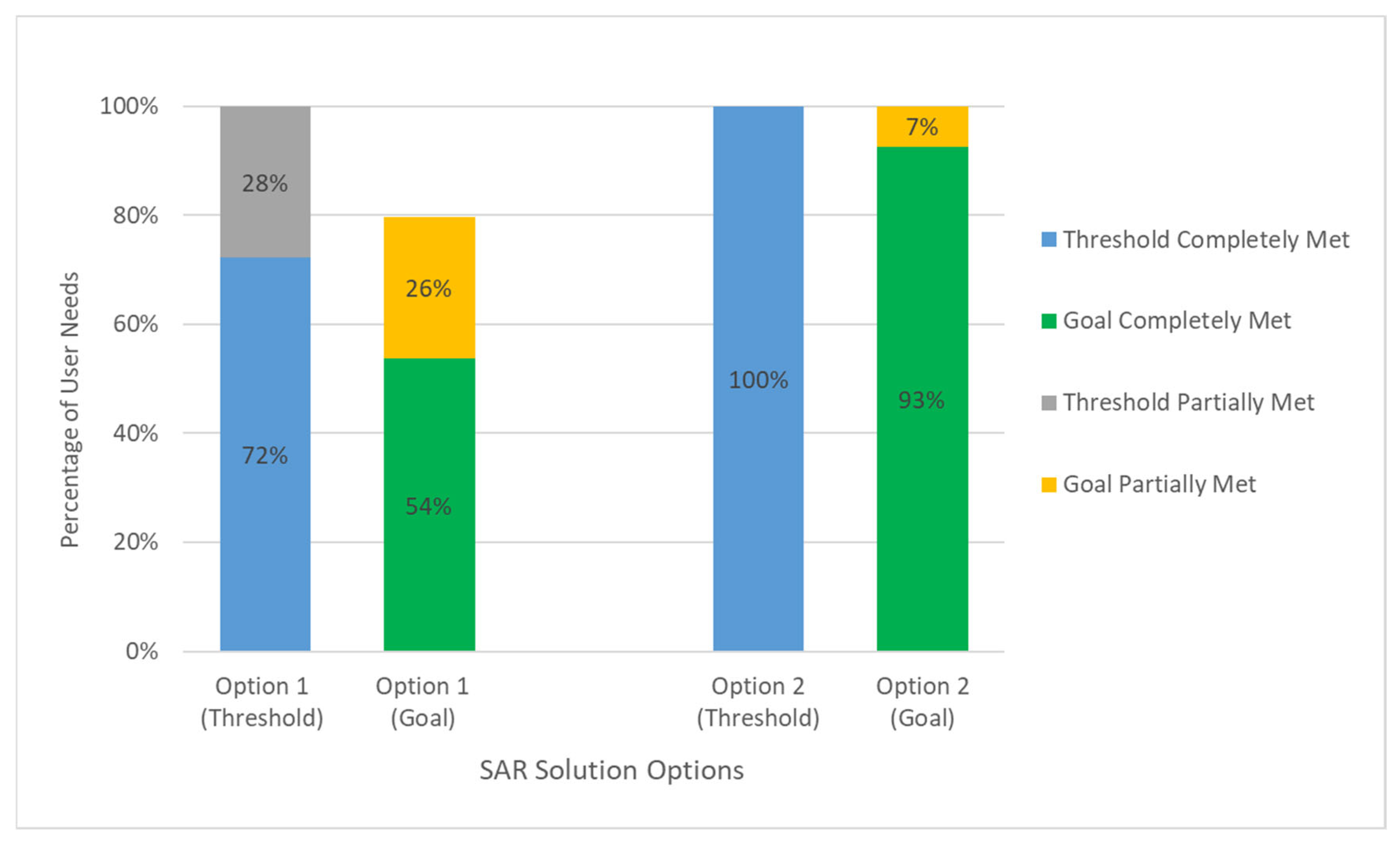
3.1. HUN Analysis
3.2. Conceptual Design of SAR Mission
3.2.1. Space and Ground Segments
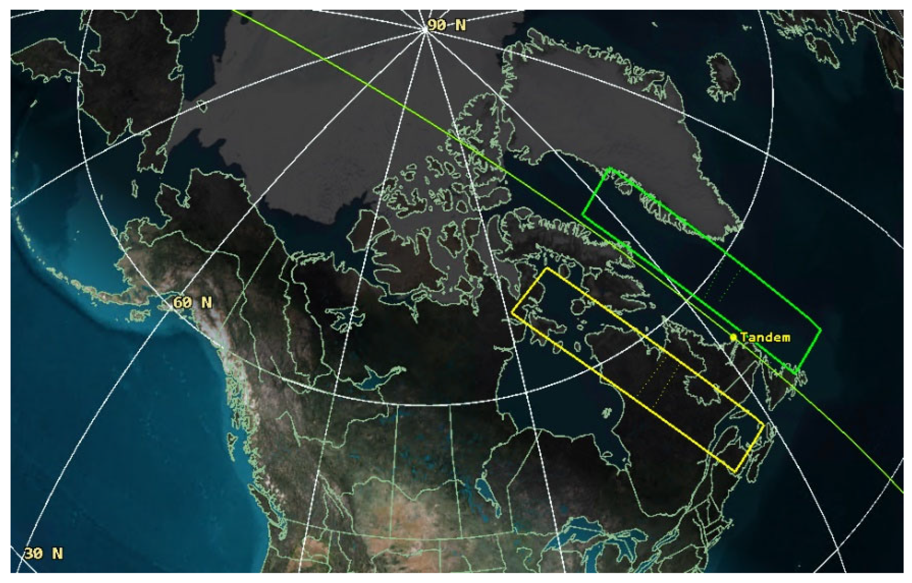
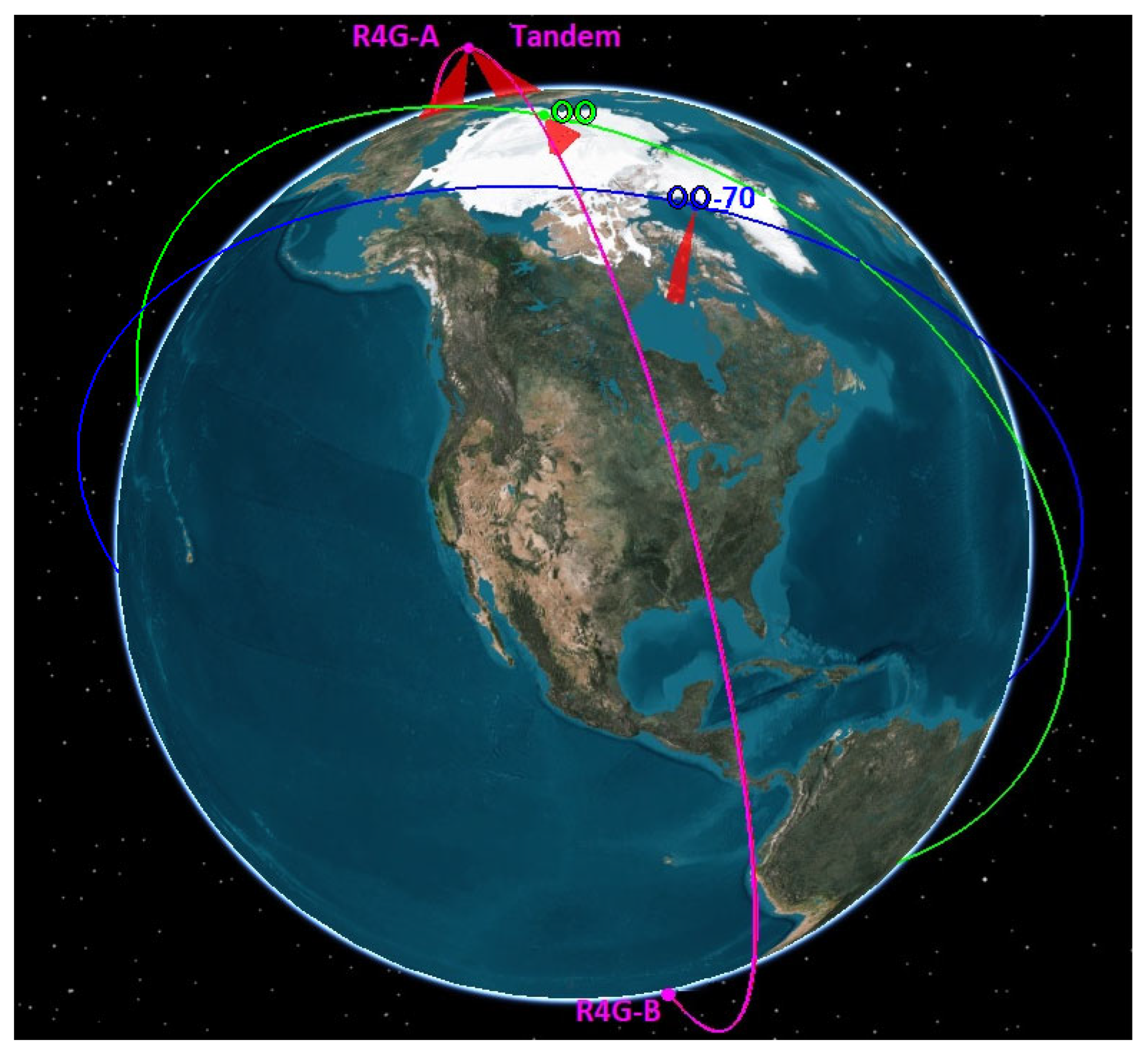
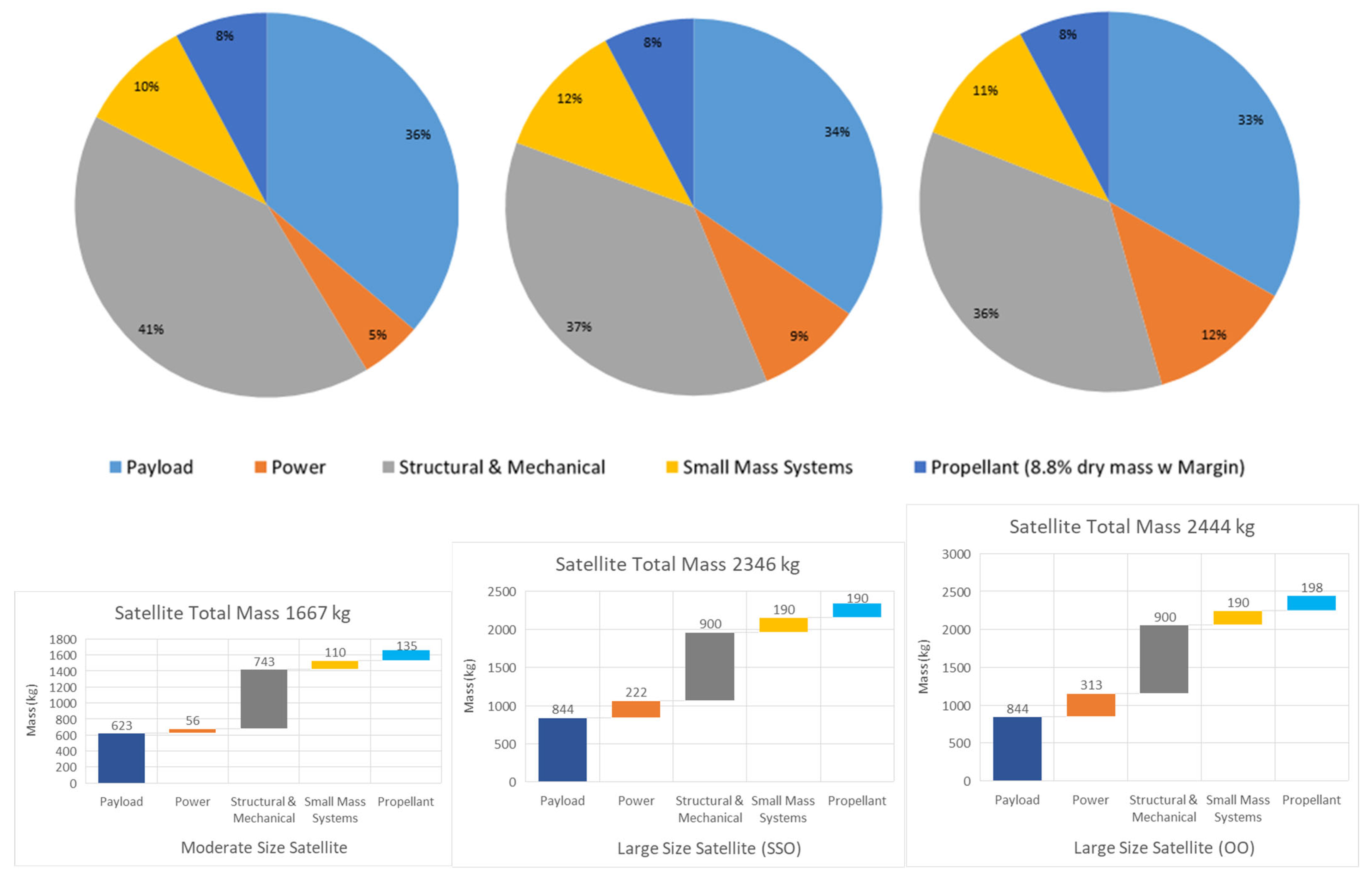
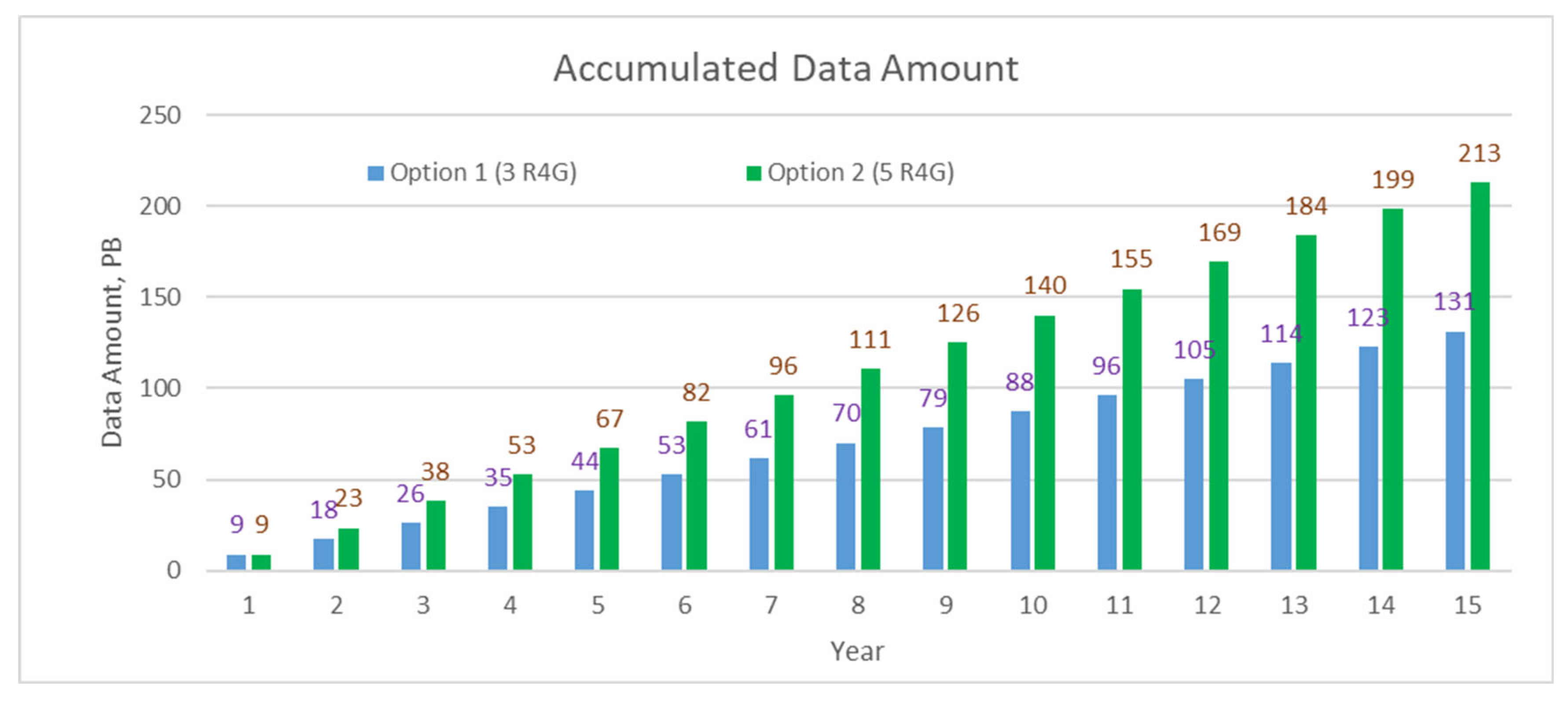
- Option 1: Three moderate (medium sized spacecraft ≥ 1400 kg) R4G (R4G stands for RADARSAT 4th Generation. RADARSAT is an official trademark of the Canadian Space Agency (CSA). The reference to "R4G" as the name of a potential future mission is used informally for discussion purposes and does not imply official endorsement or adoption by the CSA or the Government of Canada.) satellites with two of them operating in tandem, i.e., R4G (A+B+Tandem).
- Option 2: Five large (~2000 kg) R4G satellites with two operating in tandem and two others operating on optimal orbits, i.e., R4G (A+B+Tandem+2xOO (Optimal Orbit)).
3.2.2. SAR Payload and Bus Concept
- MAPS (Multiple Azimuth Phase Centers) technique;
- SCORE (Scan-on-Receive) technique.
- Capability of handling high data rate and data volume;
- Data rate proportional to swath width and bandwidth;
- Impact on on-board storage and downlink system;
- Overall mission architecture with respect to data latency to be considered;
- Multi-channel calibration (channel balancing) on-board for SCORE and on ground for MAPS.
3.2.3. SAR Imaging Performance
- The starting point is the Sentinel-1 first generation (S1FG) instrument performance parameter set (https://sentiwiki.copernicus.eu/web/s1-mission (accessed on 15 November 2025)), described by aperture size, RF transmit power capabilities (peak power 4.1–4.4 kW) and RF losses (Receiver noise figure 3.2 dB).
- Back-end and signal networks need to be upgraded to a digital beamforming architecture, which is assumed to remain in a lower order of magnitude on mass, volume, and DC power demand compared to the front end. However, this part is the most demanding evolution from Sentinel-1 first generation to the digital beamforming architecture.
- To rescale the satellite mass from the 2300 kg of S1FG, it is assumed that the scaling is dominated by the aperture size, which in turn determines the instrument mass and DC power requirements, assuming the same radiator size and transmit/receive module (TRM) capabilities. Reducing the antenna length (along flight direction) is one straightforward way for rescaling, as it limits technical and integration risks by minimizing the changes necessary for individual antenna tiles.
- Large satellite (2300 kg) with antenna 4.0 m along × 6.25 m across using 6 MAPS channels (one per two tiles);
- Moderate satellite (1600 kg) with antenna 2.5 m along × 10 m across using 8 MAPS channels (one per tile).
3.2.4. Tandem Capability
- Measurement of tidal currents and ocean circulations with very high sensitivity;
- Thermohaline circulations with high spatial resolution, including coastal regions;
- Detection of alga blooms and estimation of their drift velocity;
- Measurement of sea surface film drifts relying on 2-D motion velocity vectors.
3.2.5. Orbit Selection
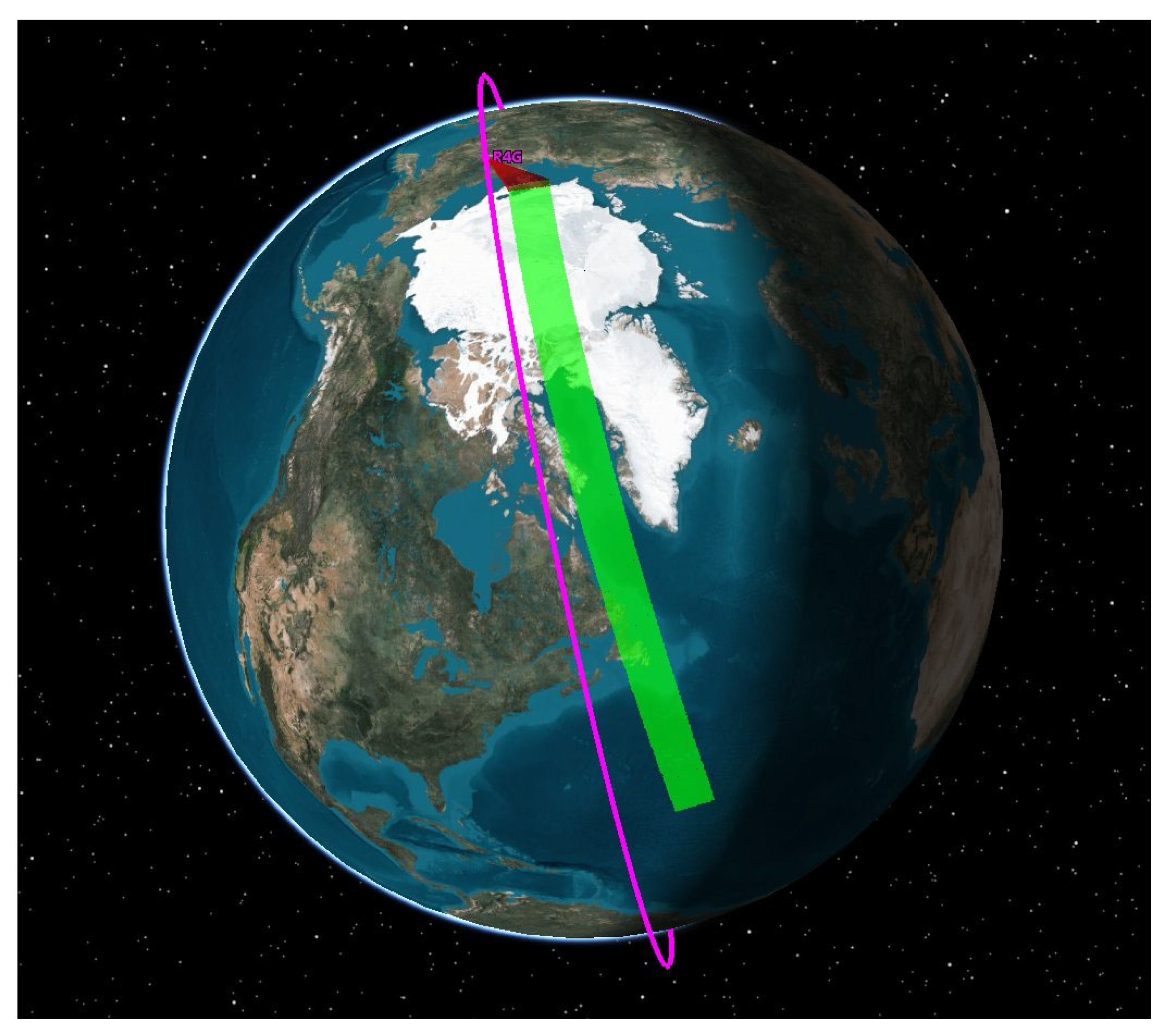
- It may be used for Copernicus missions: Sentinel-1 NG and ROSE-L. In this case, R4G can take certain advantages of data acquisition from the same orbit;
- Another reason is that this orbit allows good SAR performance for numerous applications.
3.2.6. Coverage Frequency and Revisit Time
3.2.7. Fast Tasking
3.2.8. Orbit Duty Cycle
3.2.9. Spacecraft Mass Budget Estimate
3.2.10. Data Latency
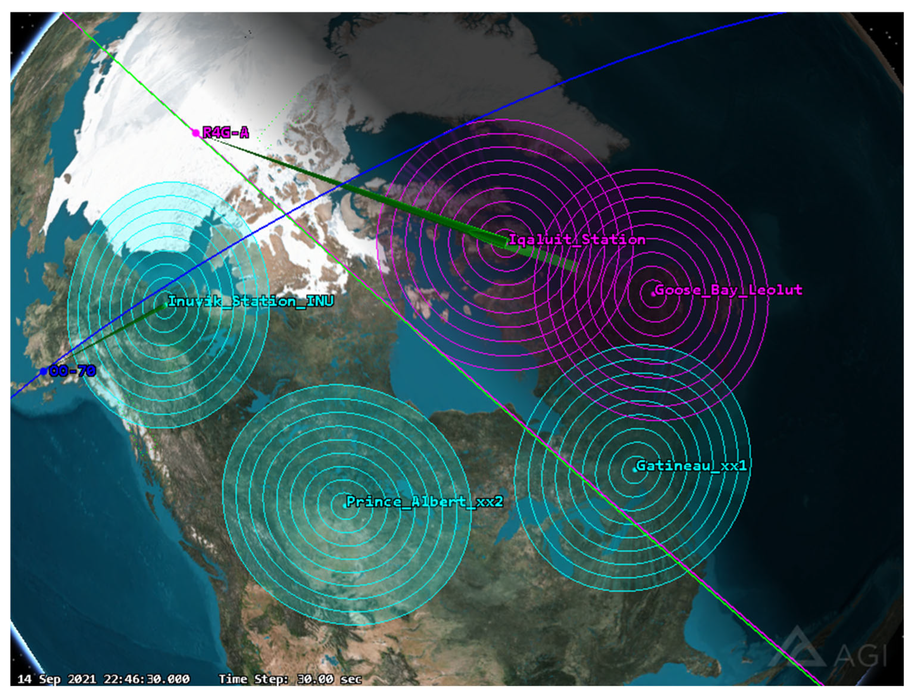
- Existing NRCan ground stations;
- New additional Canadian ground station(s);
- Commercial ground stations (Canadian and international);
- Data relay satellites.
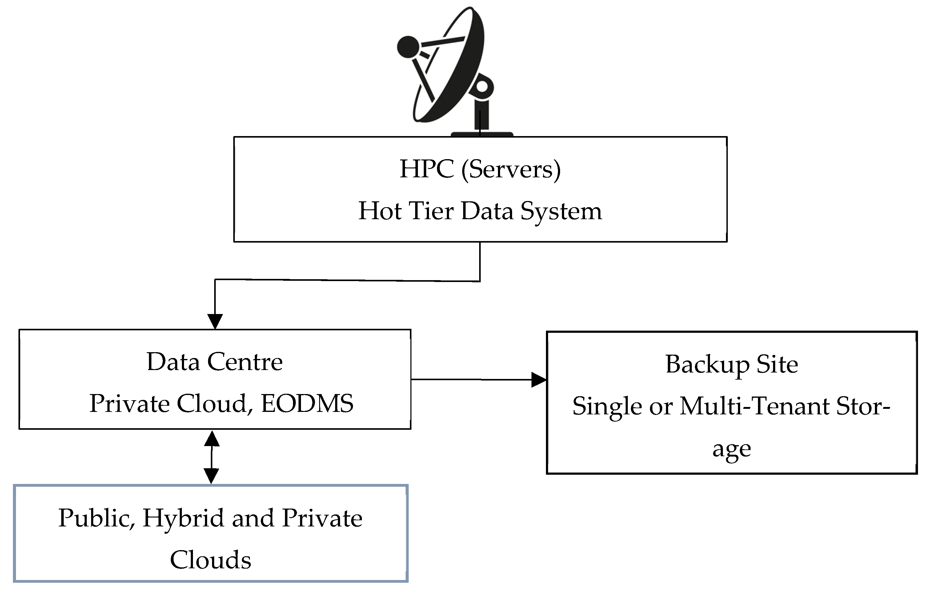
3.2.11. Ground Segment and Data Handling
3.2.12. SAR Data Handling
3.3. Programmatic Considerations
3.3.1. Cost
3.3.2. Risks
- Technical risks with the development of new systems with low technology readiness level (TRL) components may require more time and resources than expected, leading to potential delays;
- Programmatic risks due to changes in scope and schedule delivery due to supply chain issues and long lead times, and key personnel loss;
- Budget risks relevant to cost overruns and the financial stability of key contractors;
- Regulatory risks relevant to frequency licensing and compliance with government policies.
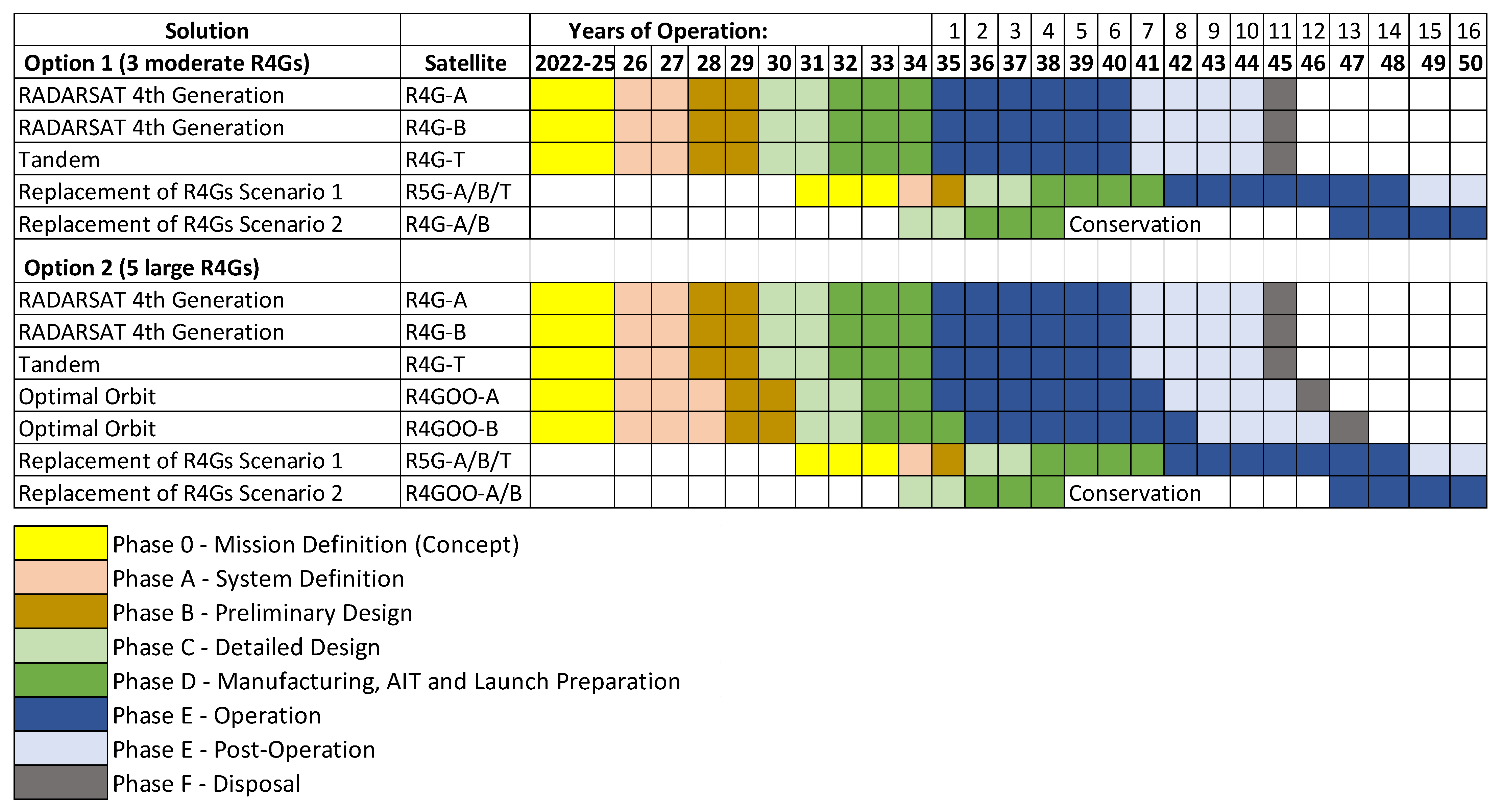
3.3.3. Schedule
- Scenario 1. Pre-build one or more R4G satellites for conservation to store them until the health of the operating R4Gs shows significant degradation. This is the cost-efficient solution, which will maximize the operation time of each satellite.
- Scenario 2. Replace all satellites with newly designed (i.e., R5G) spacecraft 10 years after R4G was launched. This scenario will have additional costs associated with R&D and design of the new R5G. The launch of R5G can be delayed if it is necessary to avoid a potential situation when both R4G and R5G are in operation (similar to RADARSAT-1 and RADARSAT-2).
4. Discussion
- An exploration into scalable satellite configurations, including small satellite options, could offer cost and schedule advantages;
- A growing tendency to overstate the advantages of compact polarimetric (CP) SAR data could be balanced with critical assessments of their actual performance in operational contexts, considering several years of RCM operation;
- A structured justifying SAR investment can help early quantify the socio-economic benefits to prioritize mission funding;
- Despite growing demand for timely and accurate EO data, governmental departments often face challenges in rapidly adopting and implementing advanced EO services. Such a delay can result in missed opportunities for enhanced public service delivery. Addressing these limitations requires greater interdepartmental coordination and stronger partnerships with industry;
- HUN document, developed by GC departments, was used as the basis for defining the mission design options; however, direct inputs from Canadian industry were not incorporated in our design. In contrast, the Europeans emphasize the integration of commercial services [150] in the process of formulating a comprehensive set of user needs and observation requirements [65,66].
5. Conclusions
Author Contributions
Funding
Data Availability Statement
Conflicts of Interest
References
- Born, G.H.; Dunne, J.A.; Lame, D.B. Seasat Mission Overview. Science 1979, 204, 1405–1406. [Google Scholar] [CrossRef]
- Elachi, C.; Brown, W.E.; Cimino, J.B.; Dixon, T.; Evans, D.L.; Ford, J.P.; Saunders, R.S.; Breed, C.; Masursky, H.; McCauley, J.F.; et al. Shuttle Imaging Radar Experiment. Science 1982, 218, 996–1003. [Google Scholar] [CrossRef] [PubMed]
- Cimino, J.; Elachi, C.; Settle, M. SIR-B-The Second Shuttle Imaging Radar Experiment. IEEE Trans. Geosci. Remote Sens. 1986, GE-24, 445–452. [Google Scholar] [CrossRef]
- Tsokas, A.; Rysz, M.; Pardalos, P.M.; Dipple, K. SAR Data Applications in Earth Observation: An Overview. Expert Syst. Appl. 2022, 205, 117342. [Google Scholar] [CrossRef]
- Paek, S.W.; Balasubramanian, S.; Kim, S.; De Weck, O. Small-Satellite Synthetic Aperture Radar for Continuous Global Biospheric Monitoring: A Review. Remote Sens. 2020, 12, 2546. [Google Scholar] [CrossRef]
- Attema, E.P.W.; Duchossois, G.; Kohlhammer, G. ERS-1/2 SAR Land Applications: Overview and Main Results. In Proceedings of the IGARSS ’98. Sensing and Managing the Environment. 1998 IEEE International Geoscience and Remote Sensing. Symposium Proceedings. (Cat. No. 98CH36174), Seattle, WA, USA, 6–10 July 1998; Volume 4, pp. 1796–1798. [Google Scholar]
- Schwartz, K.; Jeffries, M.O.; Li, S. Using ERS-1 SAR Data to Monitor the State of the Arctic Ocean Sea Ice Surface between Spring and Autumn, 1992. In Proceedings of the IGARSS ’94—1994 IEEE International Geoscience and Remote Sensing Symposium, Pasadena, CA, USA, 8–12 August 1994; Volume 3, pp. 1759–1762. [Google Scholar]
- Korsbakken, E.; Johannessen, J.A.; Johannessen, O.M. Coastal Wind Field Retrievals from ERS Synthetic Aperture Radar Images. J. Geophys. Res. 1998, 103, 7857–7874. [Google Scholar] [CrossRef]
- Lehner, S.; Schulz-Stellenfleth, J.; Schattler, B.; Breit, H.; Horstmann, J. Wind and Wave Measurements Using Complex ERS-2 SAR Wave Mode Data. IEEE Trans. Geosci. Remote Sens. 2000, 38, 2246–2257. [Google Scholar] [CrossRef]
- Shimada, T.; Kawamura, H.; Shimada, M.; Watabe, I.; Iwasaki, S.-I. Evaluation of JERS-1 SAR Images from a Coastal Wind Retrieval Point of View. IEEE Trans. Geosci. Remote Sens. 2004, 42, 491–500. [Google Scholar] [CrossRef]
- Asiyabi, R.M.; Ghorbanian, A.; Tameh, S.N.; Amani, M.; Jin, S.; Mohammadzadeh, A. Synthetic Aperture Radar (SAR) for Ocean: A Review. IEEE J. Sel. Top. Appl. Earth Obs. Remote Sens. 2023, 16, 9106–9138. [Google Scholar] [CrossRef]
- Canadian Space Agency. RADARSAT Annual Review; Canadian Space Agency: Saint-Hubert, QC, Canada, 2000; ISBN 978-0-662-65492-6. [Google Scholar]
- Zebker, H.A.; Werner, C.L.; Rosen, P.A.; Hensley, S. Accuracy of Topographic Maps Derived from ERS-1 Interferometric Radar. IEEE Trans. Geosci. Remote Sens. 1994, 32, 823–836. [Google Scholar] [CrossRef]
- Wegmuller, U.; Werner, C.L. SAR Interferometric Signatures of Forest. IEEE Trans. Geosci. Remote Sens. 1995, 33, 1153–1161. [Google Scholar] [CrossRef]
- Wegmuller, U.; Strozzi, T.; Werner, C. Forest Applications of ERS, JERS, and SIR-C SAR Interferometry. In Proceedings of the IGARSS’97. 1997 IEEE International Geoscience and Remote Sensing Symposium Proceedings. Remote Sensing—A Scientific Vision for Sustainable Development, Singapore, 3–8 August 1997; Volume 2, pp. 790–792. [Google Scholar]
- Geudtner, D.; Winter, R.; Vachon, P.W. Flood Monitoring Using ERS-1 SAR Interferometry Coherence Maps. In Proceedings of the IGARSS ’96. 1996 International Geoscience and Remote Sensing Symposium, Lincoln, NE, USA, 31 May 1996; Volume 2, pp. 966–968. [Google Scholar]
- Wegmuller, U.; Werner, C.L. Farmland Monitoring with SAR Interferometry. In Proceedings of the 1995 International Geoscience and Remote Sensing Symposium, IGARSS ’95. Quantitative Remote Sensing for Science and Applications, Firenze, Italy, 10–14 July 1995; Volume 1, pp. 544–546. [Google Scholar]
- Mattar, K.E.; Vachon, P.W.; Geudtner, D.; Gray, A.L.; Cumming, I.G.; Brugman, M. Validation of Alpine Glacier Velocity Measurements Using ERS Tandem-Mission SAR Data. IEEE Trans. Geosci. Remote Sens. 1998, 36, 974–984. [Google Scholar] [CrossRef]
- Chapron, B.; Collard, F.; Ardhuin, F. Direct Measurements of Ocean Surface Velocity from Space: Interpretation and Validation. J. Geophys. Res. 2005, 110, 2004JC002809. [Google Scholar] [CrossRef]
- Marghany, M. Finite Difference Model for Modeling Sea Surface Current from RADARSAT-1 SAR Data. In Proceedings of the 2009 IEEE International Geoscience and Remote Sensing Symposium, Cape Town, South Africa, 12–17 July 2009; pp. II-487–II-490. [Google Scholar]
- Johannessen, J.A.; Chapron, B.; Alpers, W.; Collard, F.; Cipollini, P.; Liu, A.; Horstmann, J.; da Silva, J.; Portabella, M.; Robinson, I.S.; et al. Satellite Oceanography from the ERS Synthetic Aperture Radar and Radar Altimeter: A Brief Review. In ERS Missions: 20 Years of Observing Earth; European Space Agency: Noordwijk, The Netherlands, 2013; pp. 199–224. ISBN 978-92-9221-424-1. [Google Scholar]
- Werner, M. Shuttle Radar Topography Mission (SRTM) Mission Overview. Frequenz 2001, 55, 75–79. [Google Scholar] [CrossRef]
- Romeiser, R.; Breit, H.; Eineder, M.; Runge, H.; Flament, P.; De Jong, K.; Vogelzang, J. Current Measurements by SAR Along-Track Interferometry from a Space Shuttle. IEEE Trans. Geosci. Remote Sens. 2005, 43, 2315–2324. [Google Scholar] [CrossRef]
- Miranda, N.; Rosich, B.; Meadows, P.J.; Haria, K.; Small, D.; Schubert, A.; Lavalle, M.; Collard, F.; Johnsen, H.; Monti-Guarnieri, A.; et al. The Envisat ASAR Mission: A Look Back at 10 Years of Operation. ESA-SP 2013, 772, 1–17. [Google Scholar] [CrossRef]
- Toutin, T.; Chenier, R. 3-D Radargrammetric Modeling of RADARSAT-2 Ultrafine Mode: Preliminary Results of the Geometric Calibration. IEEE Geosci. Remote Sens. Lett. 2009, 6, 611–615. [Google Scholar] [CrossRef]
- Rousseau, L.-P.; Gierull, C.; Chouinard, J.-Y. First Results from an Experimental ScanSAR-GMTI Mode on RADARSAT-2. IEEE J. Sel. Top. Appl. Earth Obs. Remote Sens. 2015, 8, 5068–5080. [Google Scholar] [CrossRef]
- Zink, M.; Krieger, G.; Fiedler, H.; Hajnsek, I.; Moreira, A. The TanDEM-X Mission Concept. In Proceedings of the 7th European Conference on Synthetic Aperture Radar, Friedrichshafen, Germany, 2–5 June 2008; pp. 1–4. [Google Scholar]
- Zink, M.; Moreira, A.; Hajnsek, I.; Rizzoli, P.; Bachmann, M.; Kahle, R.; Fritz, T.; Huber, M.; Krieger, G.; Lachaise, M.; et al. TanDEM-X: 10 Years of Formation Flying Bistatic SAR Interferometry. IEEE J. Sel. Top. Appl. Earth Obs. Remote Sens. 2021, 14, 3546–3565. [Google Scholar] [CrossRef]
- Caltagirone, F.; De Luca, G.; Covello, F.; Marano, G.; Angino, G.; Piemontese, M. Status, Results, Potentiality and Evolution of COSMO-SkyMed, the Italian Earth Observation Constellation for Risk Management and Security. In Proceedings of the 2010 IEEE International Geoscience and Remote Sensing Symposium, Honolulu, HI, USA, 25–30 July 2010; pp. 4393–4396. [Google Scholar]
- ASI COSMO-SkyMed Seconda Generazione: System and Products Description; European Space Agency: Paris, France, 2021.
- Kankaku, Y.; Osawa, Y.; Suzuki, S.; Watanabe, T. The Overview of the L-Band SAR Onboard ALOS-2. In Proceedings of the PIERS 2009 in Moscow Proceedings; PIERS: Moscow, Russia, 2009; pp. 735–738. [Google Scholar]
- Kankaku, Y.; Arikawa, Y.; Miura, S.; Motohka, T.; Kojima, Y. ALOS-4 System Design and PFM Current Status. In Proceedings of the IGARSS 2023—2023 IEEE International Geoscience and Remote Sensing Symposium, Pasadena, CA, USA, 16–21 July 2023; pp. 1998–2001. [Google Scholar]
- Potin, P.; Rosich, B.; Roeder, J.; Bargellini, P. Sentinel-1 Mission Operations Concept. In Proceedings of the 2014 IEEE Geoscience and Remote Sensing Symposium, Quebec City, QC, Canada, 13–18 July 2014. [Google Scholar]
- Xue, S.; Geng, X.; Meng, L.; Xie, T.; Huang, L.; Yan, X.-H. HISEA-1: The First C-Band SAR Miniaturized Satellite for Ocean and Coastal Observation. Remote Sens. 2021, 13, 2076. [Google Scholar] [CrossRef]
- Li, X.-M.; Zhang, T.; Huang, B.; Jia, T. Capabilities of Chinese Gaofen-3 Synthetic Aperture Radar in Selected Topics for Coastal and Ocean Observations. Remote Sens. 2018, 10, 1929. [Google Scholar] [CrossRef]
- Villano, M.; Ustalli, N.; Dell’Amore, L.; Jeon, S.-Y.; Krieger, G.; Moreira, A.; Peixoto, M.N.; Krecke, J. NewSpace SAR: Disruptive Concepts for Cost-Effective Earth Observation Missions. In Proceedings of the 2020 IEEE Radar Conference (RadarConf20), Florence, Italy, 21–25 September 2020; pp. 1–5. [Google Scholar]
- NISAR. NASA-ISRO SAR (NISAR) Mission Science Users’ Handbook; NISAR: Pasadena, CA, USA, 2021. [Google Scholar]
- Toan, T.L.; Chave, J.; Dall, J.; Papathanassiou, K.; Paillou, P.; Rechstein, M.; Quegan, S.; Saatchi, S.; Seipel, K.; Shugart, H.; et al. The Biomass Mission: Objectives and Requirements. In Proceedings of the IGARSS 2018—2018 IEEE International Geoscience and Remote Sensing Symposium, Valencia, Spain, 22–27 July 2018; pp. 8563–8566. [Google Scholar]
- Huber, S.; de Almeida, F.Q.; Villano, M.; Younis, M.; Krieger, G.; Moreira, A. Tandem-L: A Technical Perspective on Future Spaceborne SAR Sensors for Earth Observation. IEEE Trans. Geosci. Remote Sens. 2018, 56, 4792–4807. [Google Scholar] [CrossRef]
- Krieger, G.; Pardini, M.; Schulze, D.; Bachmann, M.; Borla Tridon, D.; Reimann, J.; Brautigam, B.; Steinbrecher, U.; Tienda, C.; Sanjuan Ferrer, M.; et al. Tandem-L: Main Results of the Phase A Feasibility Study. In Proceedings of the 2016 IEEE International Geoscience and Remote Sensing Symposium (IGARSS), Beijing, China, 10–15 July 2016; pp. 2116–2119. [Google Scholar]
- Younis, M.; Shimada, M.; Huber, S.; Herrero, C.T.; Krieger, G.; Moreira, A.; Uematsu, A.; Sudo, Y.; Nakamura, R.; Chishiki, Y. Tandem-L Instrument Design and SAR Performance Overview. In Proceedings of the 2014 IEEE Geoscience and Remote Sensing Symposium, Quebec City, QC, Canada, 13–18 July 2014; pp. 88–91. [Google Scholar]
- Mittermayer, J.; Krieger, G.; Bojarski, A.; Zonno, M.; Villano, M.; Pinheiro, M.; Bachmann, M.; Buckreuss, S.; Moreira, A. MirrorSAR: An HRWS Add-On for Single-Pass Multi-Baseline SAR Interferometry. IEEE Trans. Geosci. Remote Sens. 2022, 60, 5224018. [Google Scholar] [CrossRef]
- Moreira, A.; Krieger, G.; Younis, M.; Zink, M. Future Spaceborne SAR Technologies and Mission Concepts. In Proceedings of the IGARSS 2023—2023 IEEE International Geoscience and Remote Sensing Symposium, Pasadena, CA, USA, 16–21 July 2023; pp. 576–578. [Google Scholar]
- Mittermayer, J.; Krieger, G.; Moreira, A. Concepts and Applications of Multi-Static MirrorSAR Systems. In Proceedings of the 2020 IEEE Radar Conference (RadarConf20), Florence, Italy, 21–25 September 2020; pp. 1–6. [Google Scholar]
- Francioni, A.; Piemontese, M. Mission Design Concepts for next Generation Defence Space Observation Systems. In Proceedings of the 2008 IEEE Radar Conference, Rome, Italy, 26–30 May 2008; pp. 1–6. [Google Scholar]
- Rosen, P.; Kim, Y.; Eisen, H.; Shaffer, S.; Veilleux, L.; Hensley, S.; Chakraborty, M.; Misra, T.; Satish, R.; Putrevu, D.; et al. A Dual-Frequency Spaceborne SAR Mission Concept. In Proceedings of the 2013 IEEE International Geoscience and Remote Sensing Symposium—IGARSS, Melbourne, Australia, 21–26 July 2013; Volume 114, pp. 2293–2296. [Google Scholar]
- Suess, M.; De Witte, E.; Rommen, B. Earth Explorer 10 Candidate Mission Harmony. In Proceedings of the EUSAR 2022; 14th European Conference on Synthetic Aperture Radar, Leipzig, Germany, 25–27 July 2022; pp. 1–4. [Google Scholar]
- Lopez-Dekker, P.; Rott, H.; Prats-Iraola, P.; Chapron, B.; Scipal, K.; Witte, E.D. Harmony: An Earth Explorer 10 Mission Candidate to Observe Land, Ice, and Ocean Surface Dynamics. In Proceedings of the IGARSS 2019—2019 IEEE International Geoscience and Remote Sensing Symposium, Yokohama, Japan, 28 July–2 August 2019; pp. 8381–8384. [Google Scholar]
- Queiroz De Almeida, V.; Matar, J.; Rodriouez-Cassola, M.; Moreira, A.; Haagmans, R.; Bensi, P.; Petrolati, D. Orbit. Performance and Observation Scenarios for Esa’s Earth Explorer Mission Proposal Hydroterra. In Proceedings of the 2021 IEEE International Geoscience and Remote Sensing Symposium IGARSS, Brussels, Belgium, 11–16 July 2021; Volume 10, pp. 7740–7743. [Google Scholar]
- Phippen, D.; Burbidge, G.; Mak, K.; del Castillo Mena, J.; Garcia Garcia, Q.; Marquez, J.; Aleman Roda, F.; de la Fuente Arranz, C.; Stasi, M.; Troendle, S.; et al. Airbus Phase 0 Study for Earth Explorer 11: SEASTAR. In Proceedings of the EUSAR 2024—15th European Conference on Synthetic Aperture Radar, Munich, Germany, 23–26 April 2024; pp. 1012–1016. [Google Scholar]
- Jonas, C.; Velarde, C.; Gabrielli, S.; Imre, E.; Schulz, A.-T. GEO-SAR Orbit Characteristics Derived from the Hydroterra Mission Performance Model. In Proceedings of the EUSAR 2021; 13th European Conference on Synthetic Aperture Radar, Online, 29 March–1 April 2021; pp. 1–6. [Google Scholar]
- Hu, C.; Li, Y.; Chen, Z.; Liu, F.; Zhang, Q.; Monti-Guarnieri, A.V.; Hobbs, S.; Anghel, A.; Datcu, M. Distributed Spaceborne SAR: A Review of Systems, Applications, and the Road Ahead. IEEE Geosci. Remote Sens. Mag. 2025, 13, 329–361. [Google Scholar] [CrossRef]
- McCandles, S.W. The Origin, Evolution and Legacy of SEASAT. In Proceedings of the IGARSS 2003. 2003 IEEE International Geoscience and Remote Sensing Symposium. Proceedings (IEEE Cat. No. 03CH37477), Toulouse, France, 21–25 July 2003; Volume 1, pp. 32–34. [Google Scholar]
- EO4AGRI. WP2—User Requirements & GAP Analysis D2.4 Final Workshop—User Requirements and Gap Analysis in Different Sectors Report; Earth Observation for Agricultural (EO4AGR) Project Consortium, European Union: Madrid, Spain, 2021; p. 108. [Google Scholar]
- NWS. NDS 10-1 NWS Requirements, Operations and Services Improvements; National Weather Service, NOAA: Silver Spring, MD, USA, 2024. [Google Scholar]
- 24765-2017; ISO/IEC/IEEE International Standard—Systems and Software Engineering—Vocabulary. ISO: Geneva, Switzerland; IEC: Geneva, Switzerland; IEEE: Piscataway, NJ, USA, 2017. [CrossRef]
- Wu, Z.; Snyder, G.; Vadnais, C.; Arora, R.; Babcock, M.; Stensaas, G.; Doucette, P.; Newman, T. User Needs for Future Landsat Missions. Remote Sens. Environ. 2019, 231, 111214. [Google Scholar] [CrossRef]
- Lindgaard, G.; Dillon, R.; Trbovich, P.; White, R.; Fernandes, G.; Lundahl, S.; Pinnamaneni, A. User Needs Analysis and Requirements Engineering: Theory and Practice. Interact. Comput. 2006, 18, 47–70. [Google Scholar] [CrossRef]
- SEBoK Editorial Board. Guide to the Systems Engineering Body of Knowledge (SEBoK); Version 2.2; The Stevens Institute of Technology Systems Engineering Research Center; The International Council on Systems Engineering; The Institute of Electrical and Electronics Engineers (IEEE) Computer Society. 2020. Available online: https://sebokwiki.org/wiki/Development_of_SEBoK_v._2.2 (accessed on 15 November 2025).
- ISO/IEC/IEEE 15288:2023(E); ISO/IEC/IEEE International Standard—Systems and Software Engineering—System Life Cycle Processes. ISO: Geneva, Switzerland; IEC: Geneva, Switzerland; IEEE: Piscataway, NJ, USA, 2023. [CrossRef]
- 24748-2-2024; ISO/IEC/IEEE International Standard—Systems and Software Engineering—Life Cycle Management—Part 2: Guidelines for the Application of ISO/IEC/IEEE 15288 (System Life Cycle Processes). IEEE: Piscataway, NJ, USA, 2024. [CrossRef]
- 29148-2018; ISO/IEC/IEEE International Standard—Systems and Software Engineering—Life Cycle Processes—Requirements Engineering—Redline. IEEE: New York City, NY, USA, 2018; ISBN 978-1-5044-5302-8. [CrossRef]
- NASA. Systems Engineering Handbook, Rev. 1st ed.; National Aeronautics and Space Administration: Washington, DC, USA, 2007; ISBN 978-0-16-079747-7. [Google Scholar]
- ESA. Scientific Readiness Levels (SRL) Handbook; ESA-EOPSM-SRL-MA-4267. Issue 2.; European Space Agency, Earth and Mission Science Division: Noordwijk, The Netherlands, 2023. [Google Scholar]
- EC. Work Performed by the Nextspace Consortium—Full User Requirements; European Commission (Copernicus): Brussels, Belgium, 2018. [Google Scholar]
- EC. Work Performed by the Nextspace Consortium—Observation Requirements; European Commission (Copernicus): Brussels, Belgium, 2018. [Google Scholar]
- Gutman, G.; Ignatov, A. Towards a Common Language in Satellite Data Management: A New Processing Level Nomenclature. In Proceedings of the IGARSS’97. 1997 IEEE International Geoscience and Remote Sensing Symposium Proceedings. Remote Sensing—A Scientific Vision for Sustainable Development, Singapore, 3–8 August 1997; Volume 3, pp. 1252–1254. [Google Scholar]
- Lancheros, E.; Camps, A.; Park, H.; Sicard, P.; Mangin, A.; Matevosyan, H.; Lluch, I. Gaps Analysis and Requirements Specification for the Evolution of Copernicus System for Polar Regions Monitoring: Addressing the Challenges in the Horizon 2020–2030. Remote Sens. 2018, 10, 1098. [Google Scholar] [CrossRef]
- EC. User Requirements for a Copernicus Polar Observing System: Phase 3 Report: Towards Operational Products and Services; European Commission, Directorate General for Defence Industry and Space. Publications Office, European Union: Brussels, Belgium, 2021. [Google Scholar]
- WMO. WMO Observing Systems Capability Analysis and Review Tool (OSCAR)—User Manual; World Meteorological Organization: Geneva, Switzerland, 2024. [Google Scholar]
- WMO. User Manual for OSCAR/Space and OSCAR/Requirements; World Meteorological Organization: Geneva, Switzerland, 2023. [Google Scholar]
- Potin, P.; Bargellini, P.; Laur, H.; Rosich, B.; Schmuck, S. Sentinel-1 Mission Operations Concept. In Proceedings of the 2012 IEEE International Geoscience and Remote Sensing Symposium, Munich, Germany, 22–27 July 2012. [Google Scholar]
- EC. Commission Staff Working Document—Expression of User Needs for the Copernicus Programme; European Commission: Brussels, Belgium, 2019. [Google Scholar]
- ECSS. European Cooperation for Space Standardization (ECSS). In Glossary of Terms; ECSS-S-ST-00-01C; ESA-ESTEC: Noordwijk, The Netherlands, 2023. [Google Scholar]
- NASA. NASA Systems Engineering Handbook; SP-2016-6105 Rev2; National Aeronautics and Space Administration (NASA): Washington, DC, USA, 2017. [Google Scholar]
- CSA. Earth Observation Service Continuity Harmonized User Needs Document; Canadian Space Agency: St-Hubert. QC, Canada, 2020; Revision E. [Google Scholar]
- CSA. Earth Observation Service Continuity Harmonized User Needs Document; Canadian Space Agency: St-Hubert. QC, Canada, 2021; Revision F. [Google Scholar]
- Patwardhan, N.; Marrone, S.; Sansone, C. Transformers in the Real World: A Survey on NLP Applications. Information 2023, 14, 242. [Google Scholar] [CrossRef]
- Alibasic, A.; Popovic, T. Applying Natural Language Processing to Analyze Customer Satisfaction. In Proceedings of the 2021 25th International Conference on Information Technology (IT), Zabljak, Montenegro, 16–20 February 2021; pp. 1–4. [Google Scholar]
- Suess, M.; Grafmueller, B.; Zahn, R. A Novel High Resolution, Wide Swath SAR System. In Proceedings of the IGARSS 2001. Scanning the Present and Resolving the Future. Proceedings. IEEE 2001 International Geoscience and Remote Sensing Symposium (Cat. No. 01CH37217), Sydney, NSW, Australia, 9–13 July 2001; Volume 3, pp. 1013–1015. [Google Scholar]
- Gebert, N.; Krieger, G.; Moreira, A. Digital Beamforming on Receive: Techniques and Optimization Strategies for High-Resolution Wide-Swath SAR Imaging. IEEE Trans. Aerosp. Electron. Syst. 2009, 45, 564–592. [Google Scholar] [CrossRef]
- Villano, M.; Krieger, G.; Jäger, M.; Moreira, A. Staggered SAR: Performance Analysis and Experiments with Real Data. IEEE Trans. Geosci. Remote Sens. 2017, 55, 6617–6638. [Google Scholar] [CrossRef]
- Kim, J.H.; Younis, M.; Moreira, A.; Wiesbeck, W. Spaceborne MIMO Synthetic Aperture Radar for Multimodal Operation. IEEE Trans. Geosci. Remote Sens. 2015, 53, 2453–2466. [Google Scholar] [CrossRef]
- Wang, W.-Q. Multi-Antenna Synthetic Aperture Radar; CRC Press: Boca Raton, FL, USA, 2013. [Google Scholar]
- Younis, M.; Huber, S.; Patyuchenko, A.; Bordoni, F.; Krieger, G. Performance Comparison of Reflector-and Planar-Antenna Based Digital Beam-Forming SAR. Int. J. Antennas Propag. 2009, 2009, 614931. [Google Scholar] [CrossRef]
- Chuang, C.-L.; Shaffer, S.; Niamsuwan, N.; Li, S.; Liao, E.; Lim, C.; Duong, V.; Volain, B.; Vines, K.; Yang, M.-W.; et al. NISAR L-Band Digital Electronics Subsystem: A Multichannel System with Distributed Processors for Digital Beam Forming and Mode Dependent Filtering. In Proceedings of the 2016 IEEE Radar Conference (RadarConf), Philadelphia, PA, USA, 2–6 May 2016; pp. 1–5. [Google Scholar]
- Ghaemi, H.; Fattahi, H.; Hawkins, B.; Jung, J.; Huang, B.; Brancato, V.; Shimada, J.; Gunter, G.; Shiroma, G.H.X.; Burns, R.; et al. NISAR SweepSAR Echo Simulation: Summary and Results. In Proceedings of the IGARSS 2023—2023 IEEE International Geoscience and Remote Sensing Symposium, Pasadena, CA, USA, 16–21 July 2023; pp. 876–879. [Google Scholar]
- Shibata, M.; Kuriyama, T.; Hoshino, T.; Nakamura, S.; Kankaku, Y.; Motohka, T.; Suzuki, S. SAR Techniques and SAR Processing Algorithm for ALOS-4. In Proceedings of the IGARSS 2022—2022 IEEE International Geoscience and Remote Sensing Symposium, Kuala Lumpur, Malaysia, 17–22 July 2022; pp. 7449–7451. [Google Scholar]
- Krieger, G.; Moreira, A. Multistatic SAR Satellite Formations: Potentials and Challenges. In Proceedings of the IEEE Geoscience and Remote Sensing Symposium, Seoul, Republic of Korea, 29 July 2005; Volume 4, pp. 2680–2684. [Google Scholar]
- Jung, C.H.; Choi, M.S.; Kwag, Y.K. Parameter Based SAR Simulator for Image Quality Evaluation. In Proceedings of the 2007 IEEE International Geoscience and Remote Sensing Symposium, Barcelona, Spain, 23–28 July 2007; pp. 1599–1602. [Google Scholar]
- Urhan, H.; Sutcuoglu, O. Combined Engineering and Mission Simulator for a Satellite SAR System. In Proceedings of the 5th International Conference on Recent Advances in Space Technologies—RAST2011, Istanbul, Turkey, 9–11 June 2011; pp. 354–359. [Google Scholar]
- Auer, S.; Bamler, R.; Reinartz, P. RaySAR—3D SAR Simulator: Now Open Source. In Proceedings of the 2016 IEEE International Geoscience and Remote Sensing Symposium (IGARSS), Beijing, China, 10–15 July 2016; pp. 6730–6733. [Google Scholar]
- Mancon, S.; Giudici, D.; Mapelli, D.; Valentino, A.; Rommen, B.; Dominguez, B.C. Performance Simulator for Bistatic SAR Missions. In Proceedings of the IGARSS 2018—2018 IEEE International Geoscience and Remote Sensing Symposium, Valencia, Spain, 22–27 July 2018; pp. 5655–5658. [Google Scholar]
- Giudici, D.; Leanza, A.; Guarnieri, A.M.; Recchia, A. End-to-End Simulator of Geosynchronous SAR Data for System Performance Assessment. In Proceedings of the IGARSS 2018—2018 IEEE International Geoscience and Remote Sensing Symposium, Valencia, Spain, 22–27 July 2018; pp. 5659–5662. [Google Scholar]
- Pyne, B.; Saito, H.; Akbar, P.R.; Hirokawa, J.; Tomura, T.; Tanaka, K. Development and Performance Evaluation of Small SAR System for 100-Kg Class Satellite. IEEE J. Sel. Top. Appl. Earth Obs. Remote Sens. 2020, 13, 3879–3891. [Google Scholar] [CrossRef]
- Sun, J.; Yu, W.; Deng, Y. The SAR Payload Design and Performance for the GF-3 Mission. Sensors 2017, 17, 2419. [Google Scholar] [CrossRef]
- Golkar, A.; Cataldo, G.; Osipova, K. Small Satellite Synthetic Aperture Radar (SAR) Design: A Trade Space Exploration Model. Acta Astronaut. 2021, 187, 458–474. [Google Scholar] [CrossRef]
- Woollard, M.; Blacknell, D.; Griffiths, H.; Ritchie, M.A. SARCASTIC v2.0—High-Performance SAR Simulation for Next-Generation ATR Systems. Remote Sens. 2022, 14, 2561. [Google Scholar] [CrossRef]
- Hsu, Y.-W. A Preliminary SAR Simulator on Matlab for System Design. In Proceedings of the IGARSS 2023—2023 IEEE International Geoscience and Remote Sensing Symposium, Pasadena, CA, USA, 16–21 July 2023; pp. 7711–7714. [Google Scholar]
- ESA-ESTEC. Space Project Management-Project Planning and Implementation; European Space Agency (ESA)-European Space Research and Technology Centre (ESTEC). ECSS Secretariat. Requirements & Standards Division: Noordwijk, The Netherlands, 2009. [Google Scholar]
- CSA. Systems Engineering Methods and Practices; CSA-SE-PR-0001. Rev C; Canadian Space Agency (CSA): Saint-Hubert, QC, Canada, 2020. [Google Scholar]
- Government Consulting Services Evaluation of the RADARSAT-2 Major Crown Project; The Canadian Space Agency: Saint-Hubert, QC, Canada, 2009.
- GAO. Assessments of Major NASA Projects; United States Government Accountability Office: Washington, DC, USA, 2022. [Google Scholar]
- Sharma, P. Updates in Commissioning Timeline for NASA-ISRO Synthetic Aperture Radar (NISAR). In Proceedings of the 2019 IEEE Aerospace Conference, Big Sky, MT, USA, 2–9 March 2019; pp. 1–12. [Google Scholar]
- Norman, A.; Das, S.; Rohr, T.; Ghidini, T. Advanced Manufacturing for Space Applications. CEAS Space J. 2023, 15, 1–6. [Google Scholar] [CrossRef]
- Ghidini, T.; Grasso, M.; Gumpinger, J.; Makaya, A.; Colosimo, B.M. Additive Manufacturing in the New Space Economy: Current Achievements and Future Perspectives. Prog. Aerosp. Sci. 2023, 142, 100959. [Google Scholar] [CrossRef]
- Minacapilli, P.; Zurita, F.; Campo Perez, S.; Rodríguez Pérez-Silva, A.; Escudero, D. Small Satellites Mission Design Enhancement through MBSE and DDSE Toolchain. In Proceedings of the Model Based Space Systems and Software Engineering (MBSE2022), Toulouse, France, 22–24 November 2022. [Google Scholar]
- Hunt, C.D.; van Pelt, M.O. Comparing NASA and ESA Cost Estimating Methods for Human Missions to Mars. In Proceedings of the International Society of Parametric Analysts 26th Internatuonal Conference, Frascati, Italy, 10–12 May 2004. [Google Scholar]
- Chang, Y.-K.; Hwang, K.-L.; Kang, S.-J. SEDT (System Engineering Design Tool) Development and Its Application to Small Satellite Conceptual Design. Acta Astronaut. 2007, 61, 676–690. [Google Scholar] [CrossRef]
- NASA. Cost Estimating Handbook (CEH); Version 4.0; NASA: Washington, DC, USA, 2015. [Google Scholar]
- Trivailo, O.; Sippel, M.; Şekercioğlu, Y.A. Review of Hardware Cost Estimation Methods, Models and Tools Applied to Early Phases of Space Mission Planning. Prog. Aerosp. Sci. 2012, 53, 1–17. [Google Scholar] [CrossRef]
- Trivailo, O. Innovative Cost Engineering Approaches, Analyses and Methods Applied to SpaceLiner—An Advanced, Hypersonic, Suborbital Spaceplane Case-Study; Monash University: Melbourne, Australia, 2015. [Google Scholar]
- Larson, E.W.; Gray, C.F. A Guide to the Project Management Body of Knowledge: PMBOK (®) Guide, 6th ed.; Project Management Institute: Newtown Square, PA, USA, 2017. [Google Scholar]
- Larson, W.J.; Wertz, J.R. Space Mission Analysis and Design, 3rd ed.; Space Technology Library; Microcosm Press and Kluwer Academic Publishers: El Segundo, CA, USA, 2005. [Google Scholar]
- Fortescue, P.; Swinerd, G.; Stark, J. Spacecraft Systems Engineering; John Wiley & Sons: Hoboken, NJ, USA, 2011. [Google Scholar]
- Zakharov, I.; Chamberland, J.; Puestow, T. Cost Estimation of Future SAR Satellites. In Proceedings of the 2019 ESA Living Planet Symposium; ESA: Milan, Italy, 2019. [Google Scholar]
- Mahr, E.; Tu, A.; Gupta, A. Development of the Small Satellite Cost Model 2019 (SSCM19). In Proceedings of the 2020 IEEE Aerospace Conference, Big Sky, MT, USA, 7–14 March 2020; pp. 1–12. [Google Scholar]
- Majerowicz, W.; Shinn, S.A. Schedule Matters: Understanding the Relationship between Schedule Delays and Costs on Overruns. In Proceedings of the 2016 IEEE Aerospace Conference, Big Sky, MT, USA, 5–12 March 2016; pp. 1–8. [Google Scholar]
- Sawik, B. Space Mission Risk, Sustainability and Supply Chain: Review, Multi-Objective Optimization Model and Practical Approach. Sustainability 2023, 15, 11002. [Google Scholar] [CrossRef]
- Kossiakoff, A. Systems Engineering Principles and Practice, 2nd ed.; Wiley Series in Systems Engineering and Management; Wiley: Hoboken, NJ, USA, 2011; ISBN 978-0-470-40548-2. [Google Scholar]
- ESA-ESTEC. Requirements & Standards Division. In Space Project Management-Risk Management; ECSS-M-ST-80C; European Space Agency (ESA) European Space Research and Technology Centre (ESTEC): Noordwijk, The Netherlands, 2008. [Google Scholar]
- MDA. RADARSAT-2 Product Format Definition; MacDonald, Dettwiler and Associates Ltd.: Richmond, BC, Canada, 2018. [Google Scholar]
- Villano, M.; Krieger, G.; Moreira, A. Advanced Spaceborne SAR Systems with Planar Antenna. In Proceedings of the 2017 IEEE Radar Conference (RadarConf), Seattle, WA, USA, 8–12 May 2017; pp. 152–156. [Google Scholar]
- Villano, M.; Peixoto, M.N. Characterization of Nadir Echoes in Multiple-Elevation-Beam SAR With Constant and Variable Pulse Repetition Interval. IEEE Trans. Geosci. Remote Sens. 2022, 60, 1–9. [Google Scholar] [CrossRef]
- Heer, C.; Schaefer, C. Digital Beam Forming Technology for Phased Array Antennas. In Proceedings of the 2011 2nd International Conference on Space Technology, Athens, Greece, 15–17 September 2011; pp. 1–4. [Google Scholar]
- Younis, M.; De Almeida, F.Q.; Villano, M.; Huber, S.; Krieger, G.; Moreira, A. Digital Beamforming for Spaceborne Reflector-Based Synthetic Aperture Radar, Part 1: Basic Imaging Modes. IEEE Geosci. Remote Sens. Mag. 2021, 9, 8–25. [Google Scholar] [CrossRef]
- Younis, M.; Almeida, F.Q.D.; Villano, M.; Huber, S.; Krieger, G.; Moreira, A. Digital Beamforming for Spaceborne Reflector-Based Synthetic Aperture Radar, Part 2: Ultrawide-Swath Imaging Mode. IEEE Geosci. Remote Sens. Mag. 2022, 10, 10–31. [Google Scholar] [CrossRef]
- CLS. Sentinel-1A & Sentinel-1B Annual Performance Report for 2017; CLS: Ramonville-Saint-Agne, France, 2018. [Google Scholar]
- Villano, M.; Krieger, G.; Steinbrecher, U.; Moreira, A. Simultaneous Single-/Dual- and Quad-Pol SAR Imaging Over Swaths of Different Widths. IEEE Trans. Geosci. Remote Sens. 2020, 58, 2096–2103. [Google Scholar] [CrossRef]
- Reigber, A.; Schreiber, E.; Trappschuh, K.; Pasch, S.; Müller, G.; Kirchner, D.; Geßwein, D.; Schewe, S.; Nottensteiner, A.; Limbach, M.; et al. The High-Resolution Digital-Beamforming Airborne SAR System DBFSAR. Remote Sens. 2020, 12, 1710. [Google Scholar] [CrossRef]
- Geudtner, D.; Tossaint, M.; Davidson, M.; Torres, R. Copernicus Sentinel-1 Next Generation Mission. In Proceedings of the 2021 IEEE International Geoscience and Remote Sensing Symposium IGARSS, Brussels, Belgium, 11–16 July 2021; pp. 874–876. [Google Scholar]
- Zakharov, I.; Power, D.; Bobby, P.; Randell, C. Multi-Resolution SAR Data Analysis for Automated Retrieval of Sea Ice and Iceberg Parameters. In Proceedings of the ESA Living Planet Symposium, Edinburgh, UK, 9 September 2013. [Google Scholar]
- Dammann, D.O.; Eriksson, L.E.B.; Jones, J.M.; Mahoney, A.R.; Romeiser, R.; Meyer, F.J.; Eicken, H.; Fukamachi, Y. Instantaneous Sea Ice Drift Speed from TanDEM-X Interferometry. Cryosphere 2019, 13, 1395–1408. [Google Scholar] [CrossRef]
- Zakharov, I.; Puestow, T.; Power, D.; Howell, M. Icebergs in Sea Ice with TanDEM-X Interferometry. IEEE Geosci. Remote Sens. Lett. 2019, 16, 1070–1074. [Google Scholar] [CrossRef]
- Kugler, F.; Schulze, D.; Hajnsek, I.; Pretzsch, H.; Papathanassiou, K.P. TanDEM-X Pol-InSAR Performance for Forest Height Estimation. IEEE Trans. Geosci. Remote Sens. 2014, 52, 6404–6422. [Google Scholar] [CrossRef]
- Olesk, A.; Praks, J.; Antropov, O.; Zalite, K.; Arumäe, T.; Voormansik, K. Interferometric SAR Coherence Models for Characterization of Hemiboreal Forests Using TanDEM-X Data. Remote Sens. 2016, 8, 700. [Google Scholar] [CrossRef]
- Suchandt, S.; Runge, H. Ocean Surface Observations Using the TanDEM-X Satellite Formation. IEEE J. Sel. Top. Appl. Earth Obs. Remote Sens. 2015, 8, 5096–5105. [Google Scholar] [CrossRef]
- Rashid, M.; Gierull, C.H. Retrieval of Ocean Surface Radial Velocities With RADARSAT-2 Along-Track Interferometry. IEEE J. Sel. Top. Appl. Earth Obs. Remote Sens. 2021, 14, 9597–9608. [Google Scholar] [CrossRef]
- Gray, A.L.; Farris-Manning, P.J. Repeat-Pass Interferometry with Airborne Synthetic Aperture Radar. IEEE Trans. Geosci. Remote Sens. 1993, 31, 180–191. [Google Scholar] [CrossRef]
- Rosen, P.A.; Hensley, S.; Wheeler, K.; Sadowy, G.; Miller, T.; Shaffer, S.; Muellerschoen, R.; Jones, C.; Zebker, H.; Madsen, S. UAVSAR: A New NASA Airborne SAR System for Science and Technology Research. In Proceedings of the 2006 IEEE Conference on Radar, Syracuse, NY, USA, 24–27 April 2006; pp. 22–29. [Google Scholar]
- Oriot, H. Activity Monitoring with Airborne SAR Imagery. In Nato Sto Set Panel; STO: Palaiseau, France, 2014; Volume 191. [Google Scholar]
- Wang, Z.; Wang, Y.; Wang, B.; Hu, X.; Song, C.; Xiang, M. Human Activity Detection Based on Multipass Airborne InSAR Coherence Matrix. IEEE Geosci. Remote Sens. Lett. 2021, 19, 4013905. [Google Scholar] [CrossRef]
- Pottier, E.; Ferro-Famil, L. PolSARPro V5.0: An ESA Educational Toolbox Used for Self-Education in the Field of POLSAR and POL-INSAR Data Analysis. In Proceedings of the 2012 IEEE International Geoscience and Remote Sensing Symposium, Munich, Germany, 22–27 July 2012; pp. 7377–7380. [Google Scholar]
- Tali, R. SNAP TASKING “Snap Tasking” Is the Ability to Upload an Ad Hoc Requirement for Immediate Imaging by a Satellite. In Proceedings of the 2018 SpaceOps Conference; American Institute of Aeronautics and Astronautics: Marseille, France, 2018. [Google Scholar]
- Zhang, P.; Qin, Q.; Zhang, S.; Zhao, X.; Yan, X.; Wang, W.; Zhang, H. Near Real-Time Remote Sensing Based on Satellite Internet: Architectures, Key Techniques, and Experimental Progress. Aerospace 2024, 11, 167. [Google Scholar] [CrossRef]
- KSAT. Astro Digital Ka-Band and the Future of Big Data from Space; Kongsberg Satellite Services AS (KSAT): Tromsø, Norway, 2019. [Google Scholar]
- Scheiber, R.; Queiroz de Almeida, F.; Martone, M.; Villano, M.; Freddi, R. On-Board Payload Processing Requirements; S4Pro Consortium: Madrid, Spain, 2019. [Google Scholar]
- Doyon, M.; Smyth, J.; Kroupnik, G.; Carrie, C.; Sauvageau, M.; Levesque, J.-F.; Babiker, F.; Abbasi, V.; Giguere, C.; Côté, S.; et al. RADARSAT CONSTELLATION MISSION: Toward Launch and Operations. In Proceedings of the 2018 SpaceOps Conference, Marseille, France, 28 May–1 June 2018. [Google Scholar]
- Van Pelt, M. Phase 0 Space Mission Estimates. In Proceedings of the 2019 ICEAA Professional Development & Training Workshop, Tampa, FL, USA, 14–17 May 2019. [Google Scholar]
- EARSC. A Taxonomy for the EO Services Market: Enhancing the Perception and Performance of the EO Service Industry; European Association of Remote Sensing Companies: Brussels, Belgium, 2015. [Google Scholar]




| Development Heritage Definitions (Applied Only to RDT&E Costs) | MASCOTs Entry, % | Multiplicative Factor |
|---|---|---|
| New design with advanced development | 0–20 | >1.1–0.9 |
| Nominal new design—some heritage | 21–40 | 0.9–0.7 |
| Major modification to existing design | 41–60 | 0.5–0.7 |
| Moderate modifications | 61–80 | 0.3–0.5 |
| Basically existing design | 81–100 | 0.1–0.3 |
| Satellite Size | Resolution | Swath Width | Modeled NESZ | Comments |
|---|---|---|---|---|
| Large | 3 m | 100 km | −24 dB | NESZ derived * |
| 5 m | 100 km | −28.1 dB | 25 m2 resolution cell size, steep incidence, Stripmap | |
| 10 m | 500 km | −23 dB | NESZ derived | |
| 10 m | 350 km | −24.9 dB | 100 m2 resolution cell size | |
| 10 m | 200 km | −27.3 dB | 100 m2 resolution cell size | |
| 20 m | 500 km | −28.7 dB | 400 m2 resolution cell size | |
| 20 m | 350 km | −31 dB | NESZ derived | |
| Moderate | 3 m | 100 km | −20 dB | NESZ derived |
| 5 m | 100 km | −24.3 dB | 25 m2 resolution cell size, steep incidence, Stripmap | |
| 10 m | 200 km | −25.1 dB | 100 m2 resolution cell size | |
| 10 m | 100 km | −30 dB | NESZ derived | |
| 20 m | 500 km | −25.2 dB | 400 m2 resolution cell size | |
| 20 m | 350 km | −27 dB | NESZ derived | |
| 20 m | 200 km | −31 dB | NESZ derived |
| Mission Option | Design (Phases B–C) | Production (Phase D) | Launch | Operation (Phase E) | Total |
|---|---|---|---|---|---|
| Option 1: 3 moderate satellites | 681.3 | 622.9 | 94 | 191.4 | 1589.5 |
| Option 2: 5 large satellites | 841.5 | 1462.0 | 188.0 | 319.0 | 2843.7 |
Disclaimer/Publisher’s Note: The statements, opinions and data contained in all publications are solely those of the individual author(s) and contributor(s) and not of MDPI and/or the editor(s). MDPI and/or the editor(s) disclaim responsibility for any injury to people or property resulting from any ideas, methods, instructions or products referred to in the content. |
© 2025 by the authors. Licensee MDPI, Basel, Switzerland. This article is an open access article distributed under the terms and conditions of the Creative Commons Attribution (CC BY) license (https://creativecommons.org/licenses/by/4.0/).
Share and Cite
Zakharov, I.; Power, D.; McGuire, P.; Völker, M.; Kim, J.-H.; Emanuelli, M.; Chamberland, J.; Stott, M.; Warren, S.; Janoth, J.; et al. Next-Generation C-Band SAR Mission: Design Concept for Earth Observation Service Continuity. Remote Sens. 2025, 17, 3761. https://doi.org/10.3390/rs17223761
Zakharov I, Power D, McGuire P, Völker M, Kim J-H, Emanuelli M, Chamberland J, Stott M, Warren S, Janoth J, et al. Next-Generation C-Band SAR Mission: Design Concept for Earth Observation Service Continuity. Remote Sensing. 2025; 17(22):3761. https://doi.org/10.3390/rs17223761
Chicago/Turabian StyleZakharov, Igor, Desmond Power, Peter McGuire, Michael Völker, Jung-Hyo Kim, Matteo Emanuelli, Joseph Chamberland, Mike Stott, Sherry Warren, Juergen Janoth, and et al. 2025. "Next-Generation C-Band SAR Mission: Design Concept for Earth Observation Service Continuity" Remote Sensing 17, no. 22: 3761. https://doi.org/10.3390/rs17223761
APA StyleZakharov, I., Power, D., McGuire, P., Völker, M., Kim, J.-H., Emanuelli, M., Chamberland, J., Stott, M., Warren, S., Janoth, J., Kaptein, A., Henschel, M. D., & Ma, Y. (2025). Next-Generation C-Band SAR Mission: Design Concept for Earth Observation Service Continuity. Remote Sensing, 17(22), 3761. https://doi.org/10.3390/rs17223761


