Generalized Variational Retrieval of Full Field-of-View Cloud Fraction and Precipitable Water Vapor from FY-4A/GIIRS Observations
Highlights
- A constrained generalized variational retrieval method incorporating a cloud cost function was developed for the FY-4A/GIIRS observations, enabling full field-of-view retrievals of cloud fraction and precipitable water vapor (PWV).
- By integrating cloud parameters as auxiliary inputs to the radiative transfer model, the method substantially improved the simulation of infrared brightness temper-atures over cloudy regions and reduced model biases.
- The high-frequency, full field-of-view retrievals were used to derive precipitable water vapor (PWV) fields that closely matched ERA5 total column water vapor, exhibiting enhanced sensitivity to the evolution of high-impact weather systems such as typhoons.
- The simplified methodology proposed in this study provides a robust basis for the future assimilation and operational utilization of infrared data over cloud-affected regions in numerical weather prediction models.
Abstract
1. Introduction
- (1)
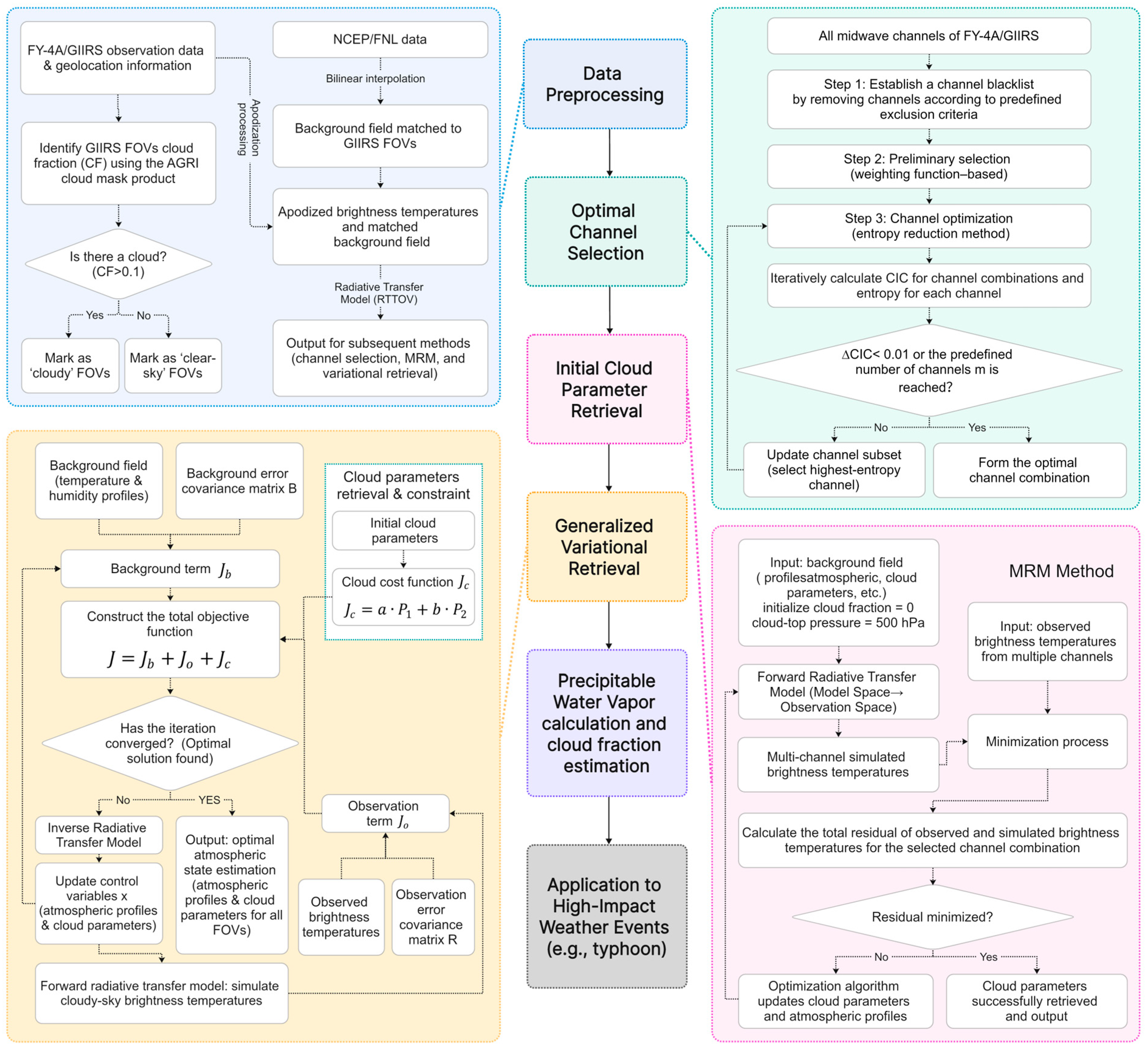
- A new generalized variational retrieval method coupled with a cloud cost function is proposed. In this method, a physical constraint term for cloud parameters is introduced into the classical variational framework [39]. This approach enables the simultaneous and synergistic retrieval of cloud fraction and atmospheric profiles for all FOV pixels and has been preliminarily and effectively applied to FY-4A/GIIRS observations in cloudy regions.
- (2)
- A complete method was developed from optimal channel selection to the initial retrieval of cloud parameters. A three-step channel selection approach based on information entropy [40] was developed, and the Minimum Residual Method (MRM) [14,24] was employed to provide the initial cloud parameters for the generalized variational retrieval. This simplified scheme, which combines physical retrieval and optimization strategies, improves the simulation accuracy of FY-4A/GIIRS brightness temperatures in cloudy regions.
- (3)
- Full field-of-view (FOV) precipitable water vapor (PWV) products with high temporal frequency were generated and applied to the monitoring of typhoon events associated with hazardous weather. Unlike most previous studies that can only provide clear-sky PWV, the proposed method generates full-FOV PWV products by integrating atmospheric profiles containing cloud information. The results preliminarily demonstrate the advantages of this approach in the identification and early warning of high-impact weather events, providing a foundation for disaster weather monitoring and future assimilation of cloud-affected observations.
2. Data and Model
2.1. Data
2.1.1. FY-4A/GIIRS Data
2.1.2. FY-4A/AGRI Data and Cloud Mask Product
2.1.3. ERA5 and FNL Data
2.1.4. Precipitation Products and Data
2.2. Experimental Data
2.3. Data Preprocessing
2.3.1. Apodization of FY-4A/GIIRS Data
2.3.2. Cloud Fraction Identification Based on the Cloud Mask Product
2.3.3. Background Field Data
2.4. Model
2.4.1. Observation Operator: Fast Radiative Transfer Model
2.4.2. Generalized Variational Retrieval Model
3. Methods
3.1. Constrained Generalized Variational Retrieval Coupled with a Cloud Cost Function
3.2. Cloud Parameter Retrieval Using the Minimum Residual Method
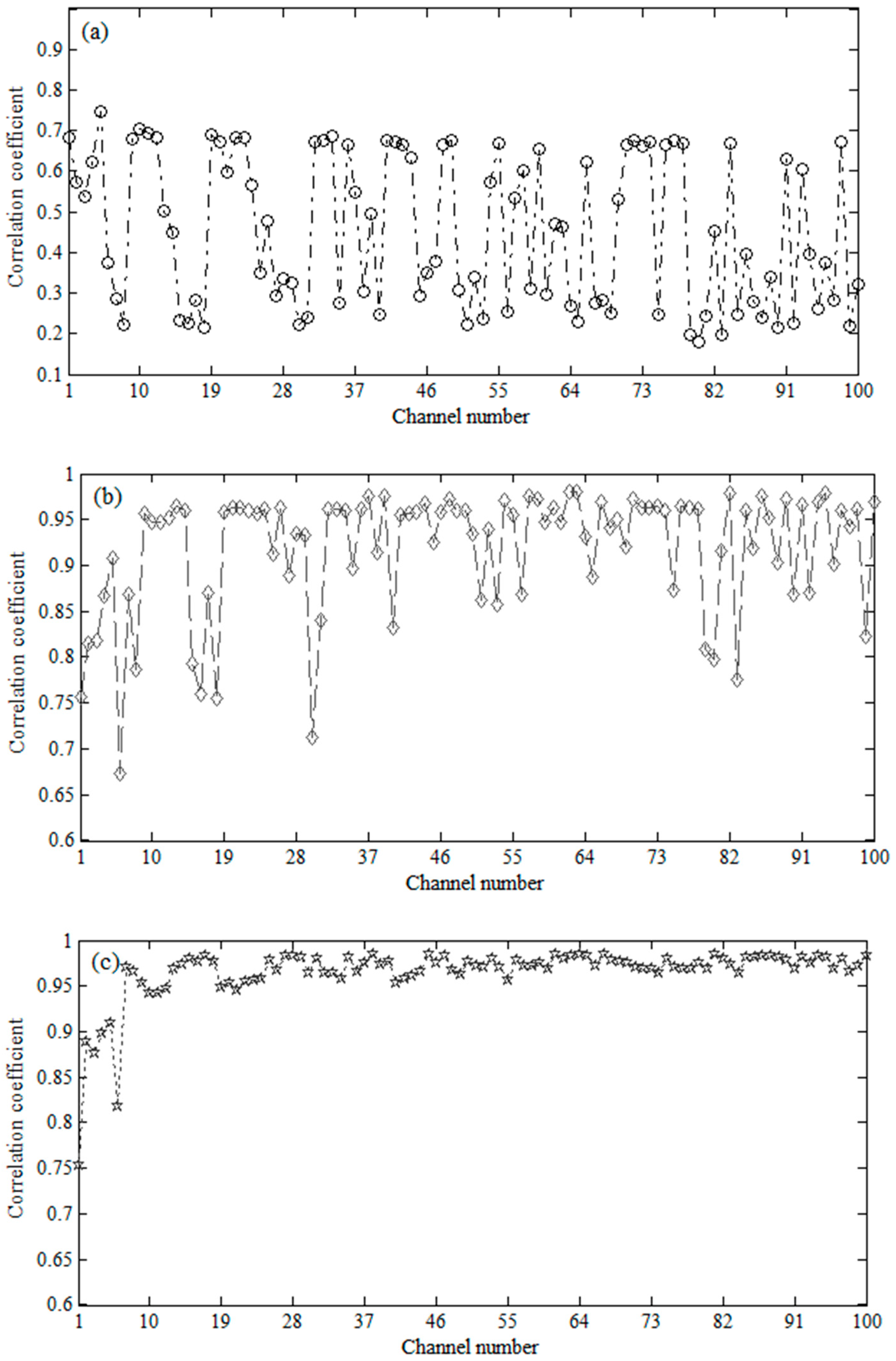
3.3. Channel Optimal Selection Based on Information Entropy “Three-Step Method”
3.3.1. Channel Preselection Based on Weighting Functions
3.3.2. Channel Optimal Selection Based on the Entropy Reduction Method
4. Results
4.1. Generalized Variational Retrieval Experiment Flowchart
4.2. FY-4A/GIIRS Channel Optimal Selection Experiment
4.3. Full Field-of-View Cloud Fraction Retrieval: Case Study of Typhoon Higos
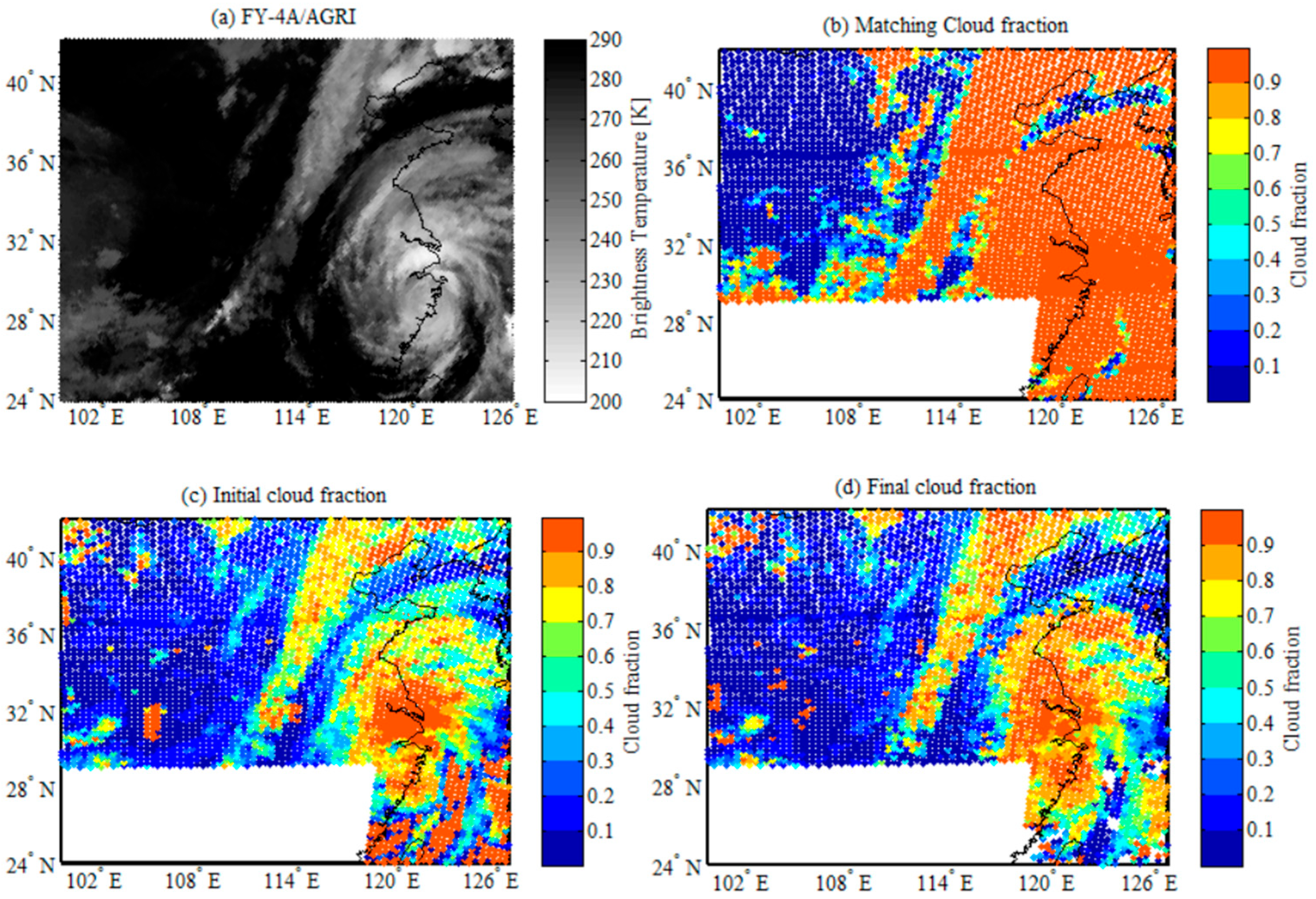
4.3.1. Initial Cloud Fraction Retrieval and Simulated Brightness Temperature Analysis in Cloudy Regions
4.3.2. Temporal Variation in Retrieved Cloud Fraction and Analysis of Brightness Temperature Deviations
4.4. Full FOV Cloud Fraction and Atmospheric Precipitable Water Retrieval: Case Study of Typhoon Lekima
4.4.1. Analysis of Cloud Fraction Information
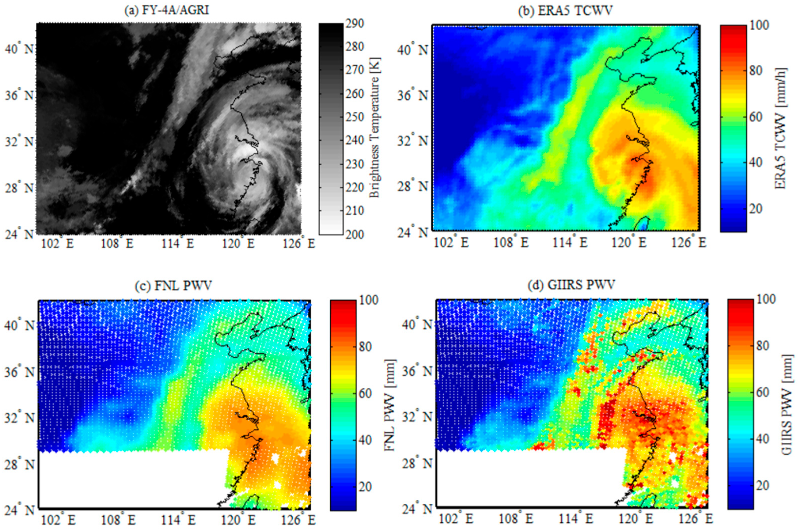
4.4.2. Analysis of Atmospheric Precipitable Water Retrieval
5. Discussion
- (1)
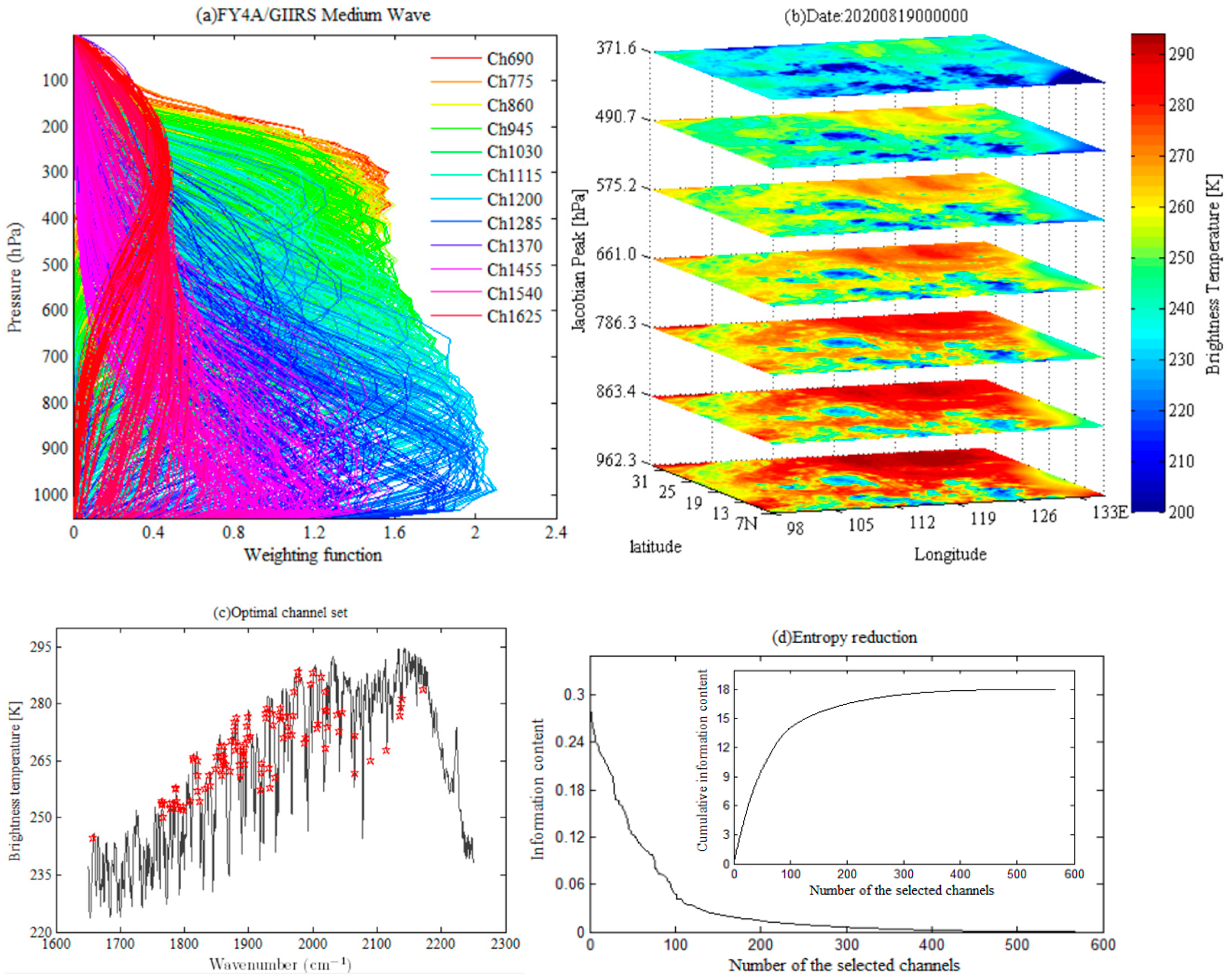
- Channel combinations in the MRM. The combination of satellite channels is the core and prerequisite for applying the MRM [14,24]. MRM utilizes the characteristic that different channels exhibit different sensitivities to clouds and the atmosphere, and retrieves cloud parameters by minimizing the overall residuals between the observed and simulated brightness temperatures across all available channels. The sensitivities of different channels of hyperspectral infrared sounders to the atmosphere and clouds are mainly reflected in their weighting functions. In this study, the “different channel combinations” in the MRM are not arbitrarily selected but are determined based on the optimal three-step channel selection strategy using information entropy.
- (2)
- Uncertainty analysis caused by the simplified cloud model. In this study, cloudy FOVs are assumed to be represented by a single-layer cloud structure. This is a reasonable and commonly used simplification adopted for computational efficiency considerations [59]. In the retrieval of hyperspectral infrared sounder data, the single-layer cloud assumption remains a widely applied and fundamental simplification model. However, it must be recognized that simplifying multilayer clouds that may exist in the real atmosphere into a single layer inevitably introduces uncertainties. These uncertainties are mainly reflected in the following aspects: the retrieved cloud-top height may not represent the actual highest cloud top; the retrieved cloud fraction may become an “equivalent value” for the entire cloud layer, thus failing to capture the true vertical structure [60]; and the subsequent retrieval of cloud microphysical parameters (e.g., effective particle radius) may also be affected by such uncertainties.
- (3)
- Physical basis for retrieving atmospheric parameters under cloud-covered FOVs. The variational retrieval method developed for FY-4A/GIIRS can estimate atmospheric variables beneath clouds, mainly owing to the following physical facts and methodological advantages. First, the incomplete cloud coverage and three-dimensional cloud structures. In weather systems such as typhoons, fine three-dimensional cloud structures often exist, including cloud gaps or optically thin edge regions [61]. Hyperspectral infrared sounders contain thousands of channels with varying sensitivities to cloud optical thickness, allowing certain channels to partially penetrate thin clouds or cloud gaps and thereby acquire information about the atmosphere beneath the clouds. Second, the advantages of the variational retrieval method. The core of the variational approach lies in the synergistic use of all selected channel observations. Even when thick clouds cause most channels to become saturated, the method can still utilize the limited but effective signals from a few channels that are sensitive to the middle and lower atmosphere and can partially penetrate cloudy regions (such as atmospheric window channels). These signals, combined with the background field, jointly constrain the temperature and humidity profiles beneath the clouds. This capability forms the physical foundation for the current all-sky assimilation of satellite infrared brightness temperature observations and is key to further improving numerical weather prediction [16].
- (4)
- Key constraints in the retrieval method for cloud-covered FOVs. In variational retrieval, the background field is usually derived from the forecast field of numerical weather prediction (NWP) models. In regions with cloud coverage and sparse observational information, the background field provides essential initial guesses and constraints [62]. The background field embodies the physical laws governing atmospheric dynamical and thermodynamical processes and thus provides a reasonable vertical structure of temperature and humidity profiles. Its role within the variational framework is to prevent physically unrealistic jumps in the retrieval results [63]. The function of the retrieval method is to use satellite observations to correct or adjust the information contained in the background field. Under typhoon conditions, although the background field may not be perfect, it can still provide typical features of water vapor distribution within the typhoon circulation, such as PWV near the eyewall region. The retrieval method employs a radiative transfer model (e.g., RTTOV) as the forward operator, which explicitly describes how radiation is absorbed, emitted, and scattered under different cloud and atmospheric conditions. This ensures that the retrieval process strictly follows the laws of physics. The background term in the cost function serves as a constraint to ensure that the final retrieval does not deviate excessively from a physically reasonable state. The strategy of using the background field as a supplement and physical constraint in regions with insufficient observational information is also a key principle in all-sky data assimilation, ensuring the stability and physical consistency of the retrieval results [16].
- (5)
- Analysis of the applicability of the generalized variational retrieval method. The variational retrieval method for cloud parameters and PWV developed in this study holds theoretical potential for global application. However, its practical performance may be influenced by regional weather extremes (e.g., strong convection) and requires localized validation in different climatic zones. Additionally, global implementation would require substantial computational resources. As a result, the operational application of the method in this study is constrained by both computational resources and the timeliness of variational retrieval. Future work will focus on improving computational efficiency through algorithm optimization. The exploration of acceleration techniques, such as machine learning, will be pursued to enhance processing speed while maintaining accuracy, thus better meeting the demands of real-time weather forecasting. Furthermore, the method’s applicability will be comprehensively evaluated using diverse global datasets, with particular focus on its performance in regions with complex weather systems and key areas along the Belt and Road Initiative.
6. Conclusions
- (1)
- Retrieval of initial cloud parameters.
- (2)
- Generalized variational retrieval of cloud parameters.
- (3)
- Retrieval and application of atmospheric precipitable water vapor (PWV).
Author Contributions
Funding
Data Availability Statement
Acknowledgments
Conflicts of Interest
References
- Wang, G.; Han, W.; Yuan, S.; Wang, J.; Yin, R.Y.; Ye, S.; Xie, F. Retrieval of high-frequency temperature profiles by FY-4A/GIIRS based on generalized ensemble learning. J. Meteor. Soc. Japan 2024, 102, 241–264. [Google Scholar] [CrossRef]
- Liu, Z.Q.; Min, M.; Li, J.; Sun, F.L.; Di, D.; Ai, Y.F.; Li, Z.L.; Qin, D.Y.; Li, G.C.; Lin, Y.J.; et al. Local severe storm tracking and warning in pre-convection stage from the new generation geostationary weather satellite measurements. Remote Sens. 2019, 11, 383. [Google Scholar] [CrossRef]
- Kalmus, P.; Kahn, B.H.; Freeman, S.W.; van den Heever, S.C. Trajectory-enhanced AIRS observations of environmental factors driving severe convective storms. Mon. Weather Rev. 2019, 147, 1633–1653. [Google Scholar] [CrossRef]
- Smith, W.L.; Zhang, Q.; Shao, M.; Weisz, E. Improved severe weather forecasts using LEO and GEO satellite soundings. J. Atmos. Ocean. Technol. 2020, 37, 1203–1218. [Google Scholar] [CrossRef]
- Geer, A.J. Correlated observation error models for assimilating all-sky infrared radiances. Atmos. Meas. Tech. 2019, 12, 3629–3657. [Google Scholar] [CrossRef]
- Lim, A.H.; Li, Z.; Nebuda, S.E.; Jung, J.A. Assimilation of radiance tendency observations from geostationary satellites in NCEP’s Global Forecast System. Q. J. R. Meteorol. Soc. 2025, e70005. [Google Scholar] [CrossRef]
- Xie, Q.; Li, D.Q.; Yang, Y.; Ma, Y.Y.; Pan, X.; Chen, M. Impact of assimilating atmospheric motion vectors from Himawari-8 and clear-sky radiance from FY-4A GIIRS on binary typhoons. Atmos. Res. 2023, 282, 106550. [Google Scholar] [CrossRef]
- McNally, A.P. A note on the occurrence of cloud in meteorologically sensitive areas and the implications for advanced infrared sounders. Q. J. R. Meteorol. Soc. 2002, 128, 2551–2556. [Google Scholar] [CrossRef]
- Wang, G.; Wang, D.Y.; Han, W.; Yin, J. Typhoon cloud system identification and forecasting using the Feng-Yun 4A/Advanced Geosynchronous Radiation Imager based on an improved fuzzy clustering and optical flow method. Adv. Meteorol. 2019, 2019, 5890794. [Google Scholar] [CrossRef]
- Feng, J.; Qin, X.H.; Wu, C.Q.; Zhang, P.; Yang, L.; Shen, X.S.; Han, W.; Liu, Y.Z. Improving typhoon predictions by assimilating the retrieval of atmospheric temperature profiles from the FengYun-4A’s Geostationary Interferometric Infrared Sounder (GIIRS). Atmos. Res. 2022, 280, 106391. [Google Scholar] [CrossRef]
- Menzel, W.P.; Schmit, T.J.; Zhang, P.; Li, J. Satellite-based atmospheric infrared sounder development and applications. Bull. Am. Meteorol. Soc. 2018, 99, 583–603. [Google Scholar] [CrossRef]
- English, S.J.; Eyre, J.R.; Smith, J.A. A cloud-detection scheme for use with satellite sounding radiances in the context of data assimilation for numerical weather prediction. Q. J. R. Meteorol. Soc. 1999, 125, 2359–2378. [Google Scholar] [CrossRef]
- McNally, A.P.; Watts, P.D. A cloud detection algorithm for high-spectral-resolution infrared sounders. Q. J. R. Meteorol. Soc. 2003, 129, 3411–3423. [Google Scholar] [CrossRef]
- Eyre, J.R.; Menzel, W.P. Retrieval of cloud parameters from satellite sounder data: A simulation study. J. Appl. Meteorol. Clim. 1989, 28, 267–275. [Google Scholar] [CrossRef]
- Pangaud, T.; Fourrie, N.; Guidard, V.; Dahoui, M.; Rabier, F. Assimilation of AIRS radiances affected by Mid-to-Low-Level clouds. Mon. Weather Rev. 2009, 137, 4276–4292. [Google Scholar] [CrossRef]
- Geer, A.J.; Lonitz, K.; Weston, P.; Kazumori, M.; Okamoto, K.; Zhu, Y.Q.; Liu, E.H.; Collard, A.; Bell, W.; Migliorini, S.; et al. All-sky satellite data assimilation at operational weather forecasting centres. Q. J. R. Meteorol. Soc. 2018, 144, 1191–1217. [Google Scholar] [CrossRef]
- Vukicevic, T.; Greenwald, T.; Zupanski, M.; Zupanski, D.; Haar, T.V.; Jones, A.S. Mesoscale cloud state estimation from visible and infrared satellite radiances. Mon. Weather Rev. 2004, 132, 3066–3077. [Google Scholar] [CrossRef]
- Meirold-Mautner, I.; Prigent, C.; Defer, E.; Pardo, J.R.; Chaboureau, J.-P.; Pinty, J.-P.; Mech, M.; Crewell, S. Radiative transfer simulations using mesoscale cloud model outputs: Comparisons with passive microwave and infrared satellite observations for midlatitudes. J. Atmos. Sci. 2007, 64, 1550–1568. [Google Scholar] [CrossRef]
- Chevallier, F.; Kelly, G. Model clouds as seen from space: Comparison with geostationary imagery in the 11-m window channel. Mon. Weather Rev. 2002, 130, 712–722. [Google Scholar] [CrossRef]
- Saunders, R.; Hocking, J.; Turner, E.; Rayer, P.; Rundle, D.; Brunel, P.; Vidot, J.; Roquet, P.; Matricardi, M.; Geer, A.; et al. An update on the RTTOV fast radiative transfer model (currently at version 12). Geosci. Model Dev. 2018, 11, 2717–2737. [Google Scholar] [CrossRef]
- White, C.H.; Heidinger, A.K.; Ackerman, S.A. Probing the explainability of neural network cloud-top pressure models for LEO and GEO imagers. Artif. Intell. Earth Syst. 2022, 1, e210001. [Google Scholar] [CrossRef]
- Pavelin, E.G.; English, S.J.; Eyre, J.R. The assimilation of cloud-affected infrared satellite radiances for numerical weather prediction. Q. J. R. Meteorol. Soc. 2008, 134, 737–749. [Google Scholar] [CrossRef]
- Wang, G.; Zhang, J.W. Generalised variational assimilation of cloud-affected brightness temperature using simulated hyper-spectral atmospheric infrared sounder data. Adv. Space Res. 2014, 54, 49–58. [Google Scholar] [CrossRef]
- Lee, A.; Sohn, B.-J.; Pavelin, E.; Kim, Y.; Kang, H.-S.; Saunders, R.; Noh, Y.-C. Assessment of cloud retrieval for IASI 1D-var cloudy-sky assimilation and improvement with an ANN approach. Weather Forecast. 2020, 35, 1363–1380. [Google Scholar] [CrossRef]
- Geer, A.J.; Migliorini, S.; Matricardi, M. All-sky assimilation of infrared radiances sensitive to mid- and upper-tropospheric moisture and cloud. Atmos. Meas. Tech. 2019, 12, 4903–4929. [Google Scholar] [CrossRef]
- Minamide, M.; Posselt, D.J. Improving tropical cyclone intensification prediction using high-resolution all-sky Geostationary Operational Environmental Satellite data assimilation. Q. J. R. Meteorol. Soc. 2025, 151, e4958. [Google Scholar] [CrossRef]
- Xie, Q.; Li, D.Q.; Yang, Y.; Zhao, Y.H.; Li, H.; Zhu, S.J.; Pan, X. Exploring the assimilation of all-Sky FY-4A GIIRS radiances and its forecasts for binary Typhoons. IEEE J. Sel. Top. Appl. Earth Obs. Remote Sens. 2025, 18, 5949–5959. [Google Scholar] [CrossRef]
- Yang, J.; Zhang, Z.Q.; Wei, C.Y.; Lu, F.; Guo, Q. Introducing the new generation of Chinese geostationary weather satellites, FengYun-4. Bull. Am. Meteorol. Soc. 2017, 98, 1637–1658. [Google Scholar] [CrossRef]
- Jang, H.-S.; Sohn, B.-J.; Chun, H.-W.; Li, J.; Weisz, E. Improved AIRS temperature and moisture soundings with local a priori information for the 1DVAR method. J. Atmos. Ocean Tech. 2017, 34, 1083–1095. [Google Scholar] [CrossRef]
- Zhu, L.; Bao, Y.; Petropoulos, G.P.; Zhang, P.; Lu, F.; Lu, Q.; Wu, Y.; Xu, D. Temperature and humidity profiles retrieval in a plain area from Fengyun-3D/HIRAS sensor using a 1D-VAR assimilation Scheme. Remote Sens. 2020, 12, 435. [Google Scholar] [CrossRef]
- Xue, Q.M.; Guan, L.; Shi, X.N. One-dimensional variational retrieval of temperature and humidity profiles from the FY4A GIIRS. Adv. Atmos. Sci. 2022, 39, 471–486. [Google Scholar] [CrossRef]
- Huang, P.Y.; Guo, Q.; Han, C.P.; Zhang, C.M.; Yang, T.H.; Huang, S. An improved method combining ANN and 1D-Var for the retrieval of atmospheric temperature profiles from FY-4A/GIIRS hyperspectral data. Remote Sens. 2021, 13, 481. [Google Scholar] [CrossRef]
- Malmgren-Hansen, D.; Laparra, V.; Nielsen, A.A.; Camps-Valls, G. Statistical retrieval of atmospheric profiles with deep convolutional neural networks. ISPRS J. Photogramm. Remote Sens. 2019, 158, 231–240. [Google Scholar] [CrossRef]
- Maier, J.; Knuteson, R. Data fusion of GEO FY-4A GIIRS and LEO hyperspectral infrared sounders with surface observations: A Hong Kong case study. J. Atmos. Ocean. Tech. 2022, 39, 259–270. [Google Scholar] [CrossRef]
- Gao, Y.; Mao, D.Y.; Wang, X.; Qin, D.Y. Evaluation of FY-4A temperature profile products and application to winter precipitation type diagnosis in southern China. Remote Sens. 2022, 14, 2363. [Google Scholar] [CrossRef]
- Kahn, B.H.; Berndt, E.B.; Case, J.L.; Kalmus, P.M.; Richardson, M.T. A nowcasting approach for low-earth-orbiting hyperspectral infrared soundings within the convective environment. Weather Forecast. 2023, 38, 1295–1312. [Google Scholar] [CrossRef]
- Esmaili, R.B.; Smith, N.; Berndt, E.B.; Dostalek, J.F.; Kahn, B.H.; White, K.; Barnet, C.D.; Sjoberg, W.; Goldberg, M. Adapting satellite soundings for operational forecasting within the hazardous weather testbed. Remote Sens. 2020, 12, 886. [Google Scholar] [CrossRef]
- Kalluri, S.; Barnet, C.; Divakarla, M.; Esmaili, R.; Nalli, N.; Pryor, K.; Reale, T.; Smith, N.; Tan, C.; Wang, T.; et al. Validation and utility of satellite retrievals of atmospheric profiles in detecting and monitoring significant weather events. Bull. Am. Meteorol. Soc. 2022, 103, E570–E590. [Google Scholar] [CrossRef]
- Deng, C.H.; Di, D.; Li, J. The effect of surface observations on enhancing the GIIRS thermodynamic profile retrieval. Remote Sens. 2024, 16, 4634. [Google Scholar] [CrossRef]
- Noh, Y.-C.; Sohn, B.-J.; Kim, Y.; Joo, S.; Bell, W.; Saunders, R. A new infrared atmospheric sounding interferometer channel selection and assessment of its impact on Met Office NWP forecasts. Adv. Atmos. Sci. 2017, 34, 1265–1281. [Google Scholar] [CrossRef]
- Zhang, L.; Niu, Z.Y.; Weng, F.Z.; Dong, P.M.; Huang, W.; Zhu, J. Impacts of direct assimilation of the FY-4A/GIIRS long-wave temperature sounding channel data on forecasting typhoon In-Fa (2021). Remote Sens. 2023, 15, 355. [Google Scholar] [CrossRef]
- Ma, Z.; Li, J.; Han, W.; Li, Z.L.; Zeng, Q.C.; Menzel, W.P.; Schmit, T.J.; Di, D.; Liu, C.-Y. Four-dimensional wind fields from geostationary hyperspectral infrared sounder radiance measurements with high temporal resolution. Geophys. Res. Lett. 2021, 48, e2021GL093794. [Google Scholar] [CrossRef]
- Wang, G.; Han, W.; Ye, S.; Yuan, S.; Wang, J.; Xie, F. FY-4A/AGRI infrared brightness temperature estimation of precipitation based on multi-model ensemble learning. Earth Space Sci. 2024, 11, e2023EA003311. [Google Scholar] [CrossRef]
- Min, M.; Wu, C.Q.; Li, C.; Liu, H.; Xu, N.; Wu, X.; Chen, L.; Wang, F.; Sun, F.L.; Qin, D.Y.; et al. Developing the science product algorithm testbed for Chinese next-generation geostationary meteorological satellites: Fengyun-4 series. J. Meteor. Res. 2017, 31, 708–719. [Google Scholar] [CrossRef]
- Hersbach, H.; Bell, B.; Berrisford, P.; Hirahara, S.; Horanyi, A.; Munoz-Sabater, J.; Nicolas, J.; Peubey, C.; Radu, R.; Schepers, D.; et al. The ERA5 global reanalysis. Q. J. R. Meteorol. Soc. 2020, 146, 1999–2049. [Google Scholar] [CrossRef]
- Niu, Z.Y.; Wang, L.W.; Kumar, P. Scale analysis of typhoon In-Fa (2021) based on FY-4A geostationary interferometric infrared sounder (GIIRS) observed and all-sky-simulated brightness temperature. Remote Sens. 2023, 15, 4035. [Google Scholar] [CrossRef]
- Sounak, K.B.; Chandrasekar, V. Cross-validation of observations between the GPM dual-frequency precipitation radar and ground based dual-polarization radars. Remote Sens. 2018, 10, 1773. [Google Scholar] [CrossRef]
- Ye, G.J.; Yu, H.; Ao, X.Y.; Zhang, X. The urban effects on the planetary boundary layer wind structures of Typhoon Lekima (2019). Atmos. Res. 2025, 313, 107756. [Google Scholar] [CrossRef]
- Di, D.; Li, J.; Han, W.; Bai, W.G.; Wu, C.Q.; Menzel, W.P. Enhancing the fast radiative transfer model for FengYun-4 GIIRS by using local training profiles. J. Geophys. Res.-Atmos. 2018, 123, 12583–12596. [Google Scholar] [CrossRef]
- Zhang, Q.; Yu, Y.; Zhang, W.M.; Luo, T.L.; Wang, X. Cloud detection from FY-4A’s geostationary interferometric infrared sounder using machine learning approaches. Remote Sens. 2019, 11, 3035. [Google Scholar] [CrossRef]
- Rabier, F.; Fourrie, N.; Chafai, D.; Prunet, P. Channel selection methods for infrared atmospheric sounding interferometer radiances. Q. J. R. Meteorol. Soc. 2002, 128, 1011–1027. [Google Scholar] [CrossRef]
- Fowler, A.M. A sampling method for quantifying the information content of IASI channels. Mon. Weather Rev. 2017, 145, 709–725. [Google Scholar] [CrossRef]
- Vittorioso, F.; Guidard, V.; Fourrie, N. An infrared atmospheric sounding interferometer-new generation (IASI-NG) channel selection for numerical weather prediction. Q. J. R. Meteorol. Soc. 2021, 147, 3297–3317. [Google Scholar] [CrossRef]
- Soden, B.J.; Held, I.M. An assessment of climate feedbacks in coupled ocean-atmosphere models. J. Clim. 2006, 19, 3354–3360. [Google Scholar] [CrossRef]
- Trenberth, K.E.; Dai, A.; Rasmussen, R.M.; Parsons, D.B. The changing character of precipitation. Bull. Am. Meteorol. Soc. 2003, 84, 1205–1218. [Google Scholar] [CrossRef]
- Zhu, L.Y.; Zhou, R.L.; Di, D.; Bai, W.G.; Liu, Z.J. Retrieval of atmospheric water vapor content in the environment from AHI/H8 using both physical and random forest methods—A case study for typhoon Maria (201808). Remote Sens. 2023, 15, 498. [Google Scholar] [CrossRef]
- Wang, H.; Wei, M.; Li, G.P.; Zhou, S.H.; Zeng, Q.F. Analysis of precipitable water vapor from GPS measurements in Chengdu region: Distribution and evolution characteristics in autumn. Adv. Space Res. 2013, 52, 656–667. [Google Scholar] [CrossRef]
- Liu, Y.; Wang, G.; Zhang, T.; Wang, P.; Xu, B.; Xia, J. Research on applicability of GNSS PWV data in Northeast China and its application in intelligent precipitation prediction. Earth Space Sci. 2025, 12, e2025EA004344. [Google Scholar] [CrossRef]
- Turner, D.D.; Löhnert, U. Information content and uncertainties in thermodynamic profiles and liquid cloud properties retrieved from the ground-based Atmospheric Emitted Radiance Interferometer (AERI). J. Appl. Meteorol. Clim. 2014, 53, 752–771. [Google Scholar] [CrossRef]
- Heidinger, A.K.; Pavolonis, M.J.; Holz, R.E.; Baum, B.A.; Berthier, S. Using CALIPSO to explore the sensitivity to cirrus height in the infrared observations from NPOESS/VIIRS and GOES-R/ABI. J. Geophys. Res.-Atmos. 2010, 115, D00H20. [Google Scholar] [CrossRef]
- Heidinger, A.K.; Pavolonis, M.J. Gazing at cirrus clouds for 25 years through a split window. Part I: Methodology. J. Appl. Meteorol. Clim. 2009, 48, 1100–1116. [Google Scholar] [CrossRef]
- Eyre, J.R.; English, S.J.; Forsythe, M. Assimilation of satellite data in numerical weather prediction. Part I: The early years. Q. J. R. Meteorol. Soc. 2020, 146, 49–68. [Google Scholar] [CrossRef]
- Lorenc, A.C. Analysis methods for numerical weather prediction. Q. J. R. Meteorol. Soc. 1986, 112, 1177–1194. [Google Scholar] [CrossRef]



| Atmospheric Parameters | Surface Parameters | Satellite Parameters | Cloud Parameters | Remarks |
|---|---|---|---|---|
| temperature, specific humidity, O3 | surface type, surface temperature, surface air pressure, 2 m temperature, 2 m specific humidity, 10 m wind (U component, V component) | satellite zenith angle and azimuth | none | “Clear-sky Simulation” |
| temperature, specific humidity, O3 | surface type, surface temperature, surface air pressure, 2 m temperature, 2 m specific humidity, 10 m wind (U component, V component) | satellite zenith angle and azimuth | effective cloud fraction, effective cloud top pressure | “Cloudy-sky Simulation” |
| Range (Unit: K) | ≤10 | (10, 11] | (11, 12] | (12, 13] | (13, 14] | >14 |
|---|---|---|---|---|---|---|
| Number of channels | 37 | 19 | 13 | 12 | 10 | 9 |
| Range (Unit: K) | ≤1.3 | (1.3, 1.7] | (1.7, 2.0] | (2, 2.5] | (2.5, 3] | >3 |
|---|---|---|---|---|---|---|
| Number of channels | 7 | 30 | 26 | 13 | 13 | 11 |
Disclaimer/Publisher’s Note: The statements, opinions and data contained in all publications are solely those of the individual author(s) and contributor(s) and not of MDPI and/or the editor(s). MDPI and/or the editor(s) disclaim responsibility for any injury to people or property resulting from any ideas, methods, instructions or products referred to in the content. |
© 2025 by the authors. Licensee MDPI, Basel, Switzerland. This article is an open access article distributed under the terms and conditions of the Creative Commons Attribution (CC BY) license (https://creativecommons.org/licenses/by/4.0/).
Share and Cite
Wang, G.; Ye, S.; Xu, B.; Zhi, X.; Liu, Q.; Liu, Y.; Pan, Y.; Fan, C.; Zhang, T.; Xie, F. Generalized Variational Retrieval of Full Field-of-View Cloud Fraction and Precipitable Water Vapor from FY-4A/GIIRS Observations. Remote Sens. 2025, 17, 3687. https://doi.org/10.3390/rs17223687
Wang G, Ye S, Xu B, Zhi X, Liu Q, Liu Y, Pan Y, Fan C, Zhang T, Xie F. Generalized Variational Retrieval of Full Field-of-View Cloud Fraction and Precipitable Water Vapor from FY-4A/GIIRS Observations. Remote Sensing. 2025; 17(22):3687. https://doi.org/10.3390/rs17223687
Chicago/Turabian StyleWang, Gen, Song Ye, Bing Xu, Xiefei Zhi, Qiao Liu, Yang Liu, Yue Pan, Chuanyu Fan, Tiening Zhang, and Feng Xie. 2025. "Generalized Variational Retrieval of Full Field-of-View Cloud Fraction and Precipitable Water Vapor from FY-4A/GIIRS Observations" Remote Sensing 17, no. 22: 3687. https://doi.org/10.3390/rs17223687
APA StyleWang, G., Ye, S., Xu, B., Zhi, X., Liu, Q., Liu, Y., Pan, Y., Fan, C., Zhang, T., & Xie, F. (2025). Generalized Variational Retrieval of Full Field-of-View Cloud Fraction and Precipitable Water Vapor from FY-4A/GIIRS Observations. Remote Sensing, 17(22), 3687. https://doi.org/10.3390/rs17223687


