Spatiotemporal Evolution and Differentiated Spatial Governance of Slope-Classified Cultivated Land Fragmentation in Rapid Urbanization: Machine Learning-Driven Insights from Guangdong Province
Abstract
1. Introduction
2. Materials and Methods
2.1. Study Area
2.2. Data Collection
2.3. Research Methods
2.3.1. Determining Slope-Classified Cultivated Land Types
2.3.2. Construction of Slope-Classified Cultivated Land Fragmentation Index System
2.3.3. Driver Analysis of Slope-Classified Cultivated Land Fragmentation
- (1)
- Explanatory variables
- (2)
- XGBoost model and SHAP interpreter
3. Results
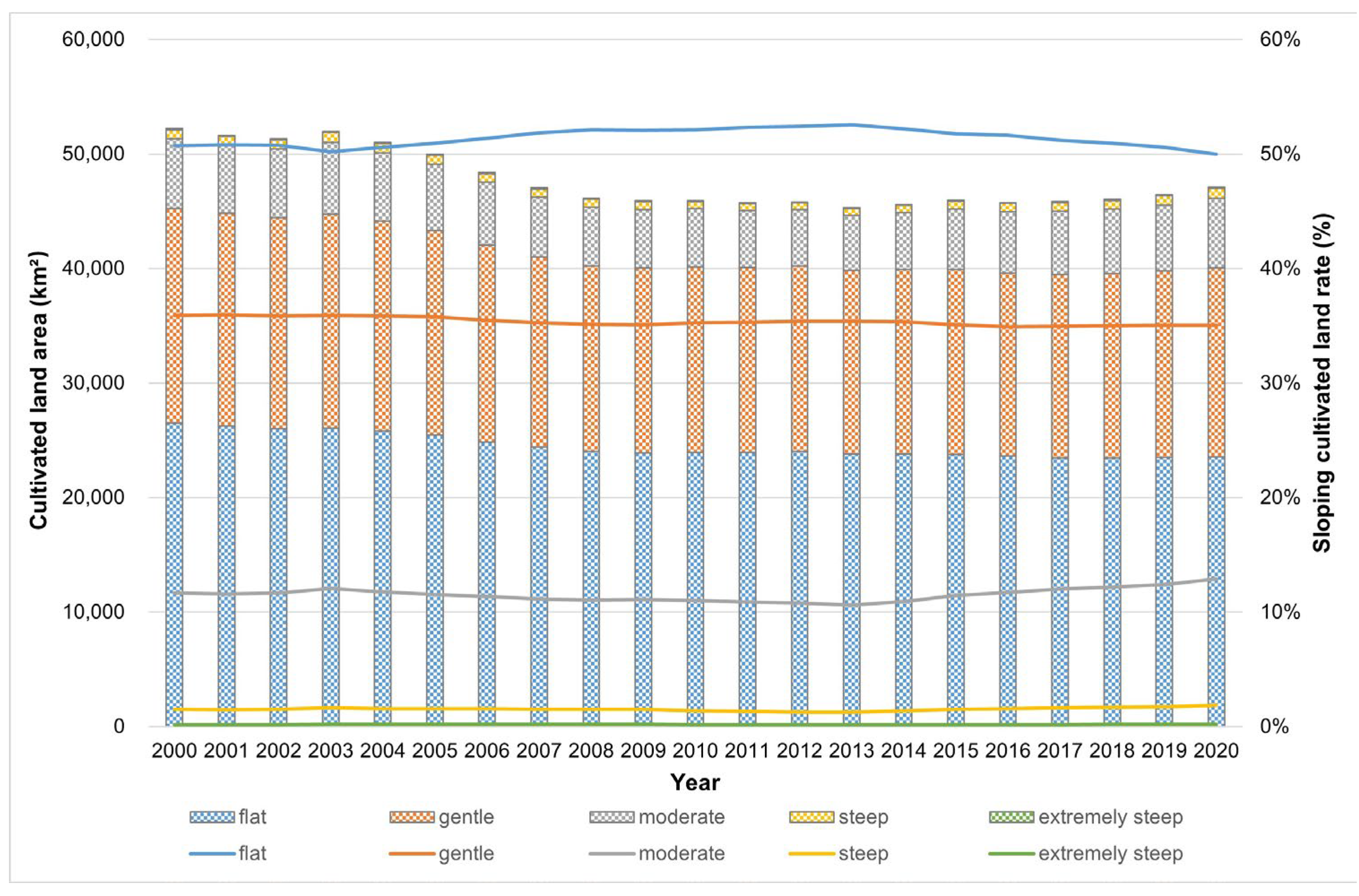
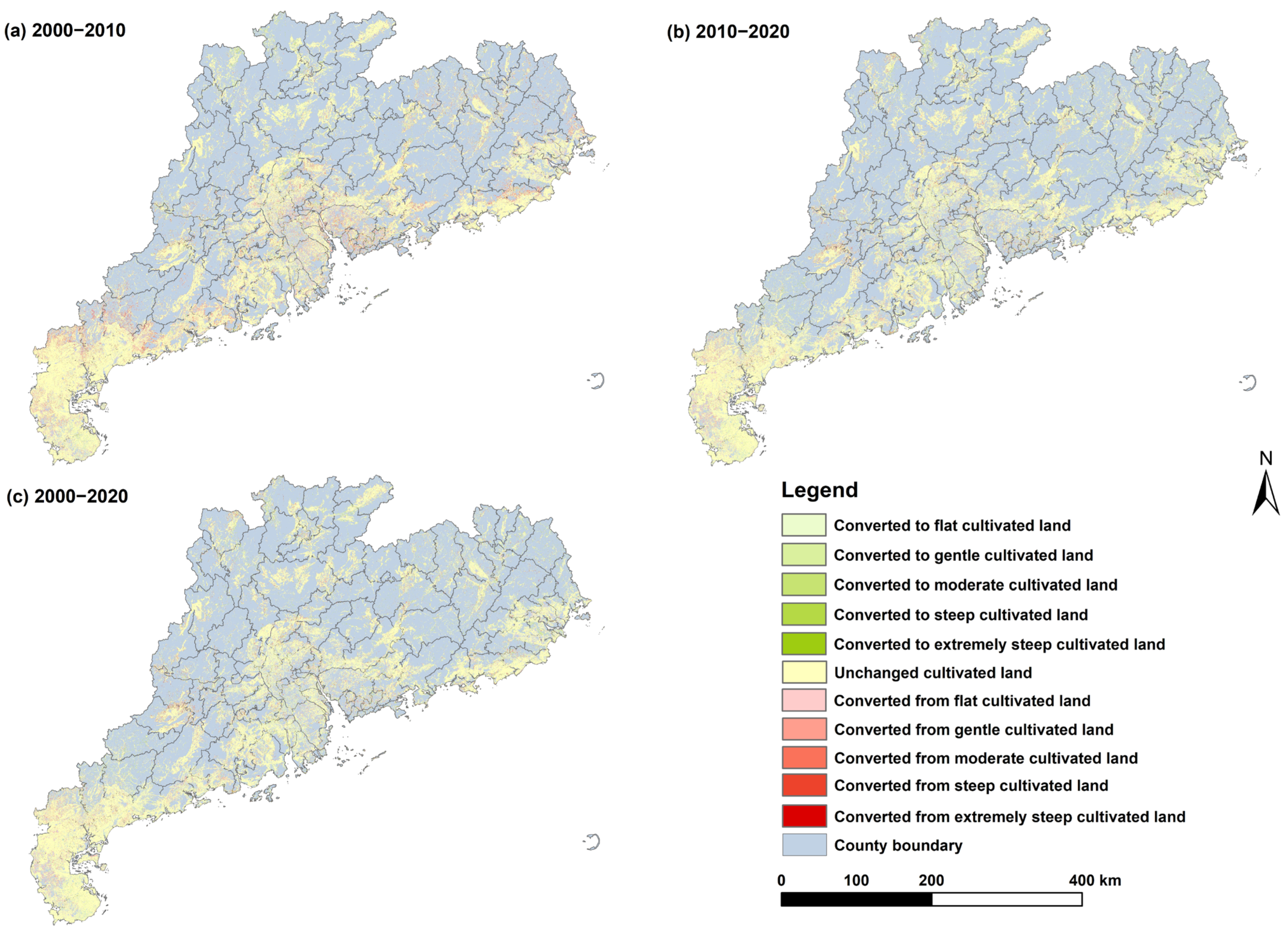
3.1. Overall Cultivated Land Use Change
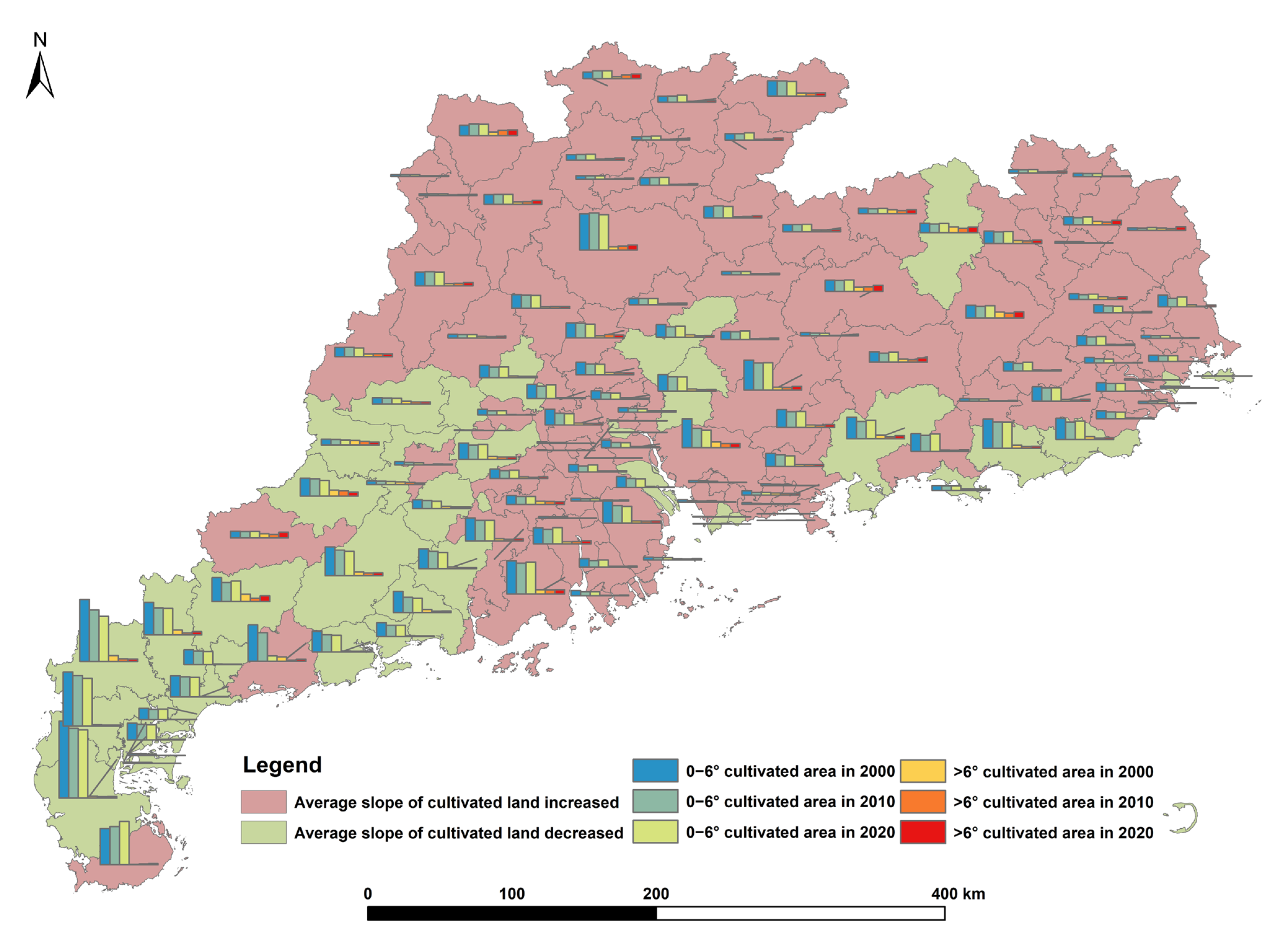
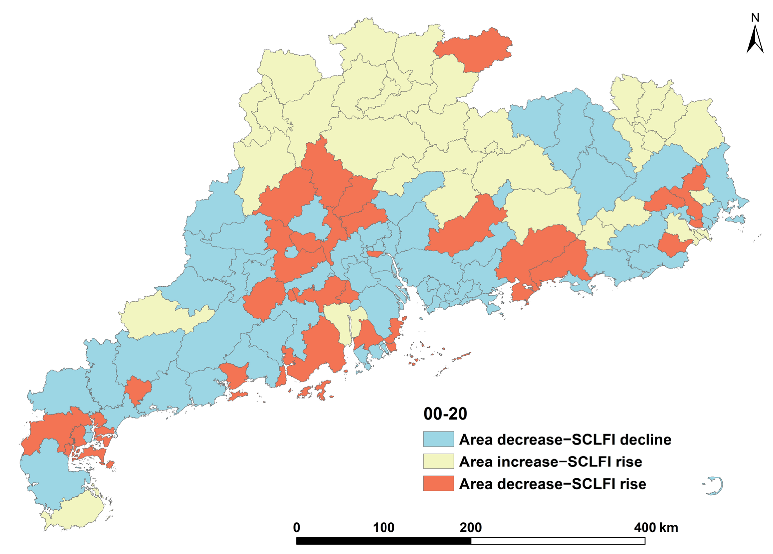
3.2. Spatial Pattern of Slope-Classified Cultivated Land Use Change at County Scale
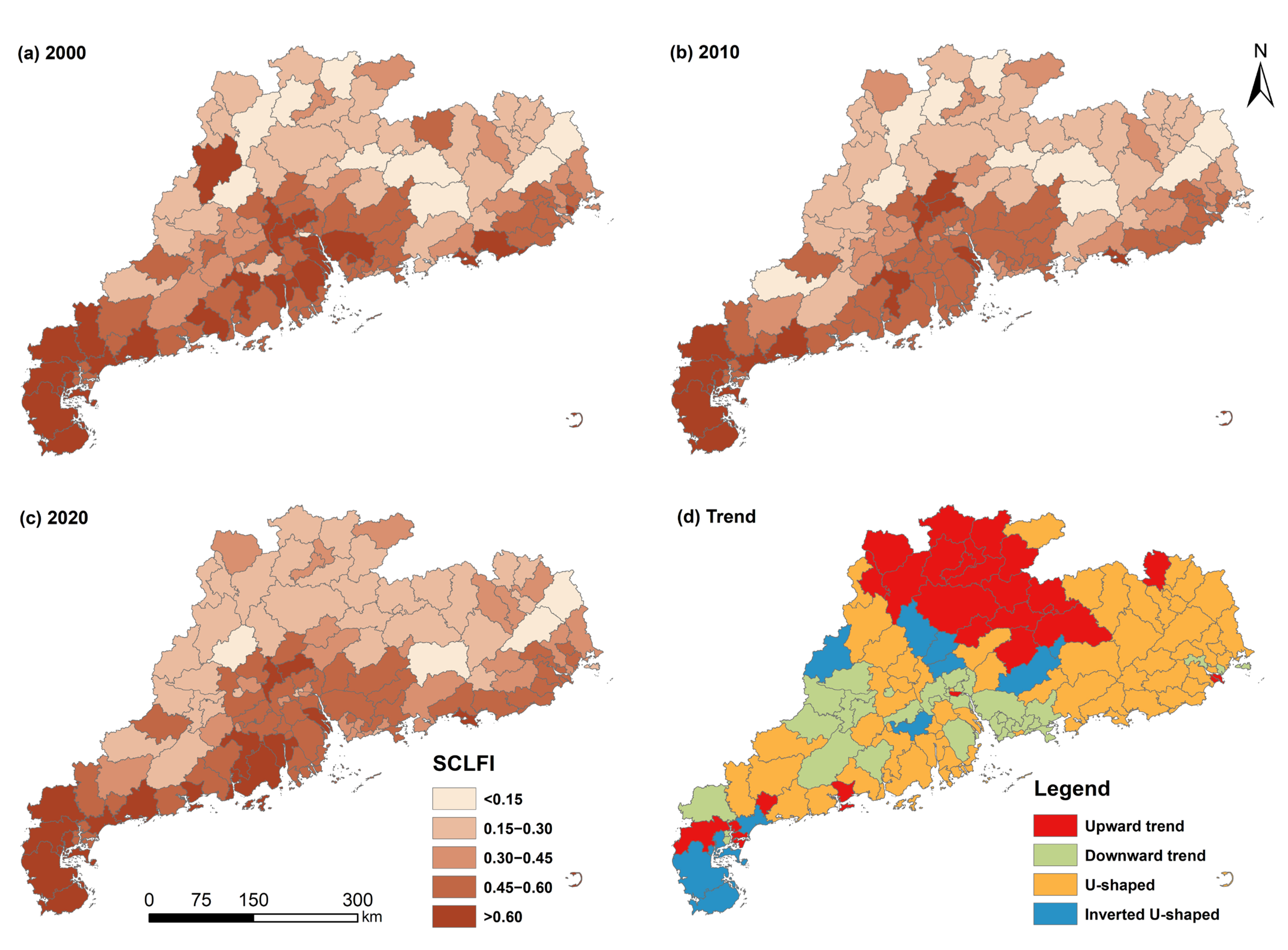
3.3. Spatial Pattern of Slope-Classified Cultivated Land Fragmentation
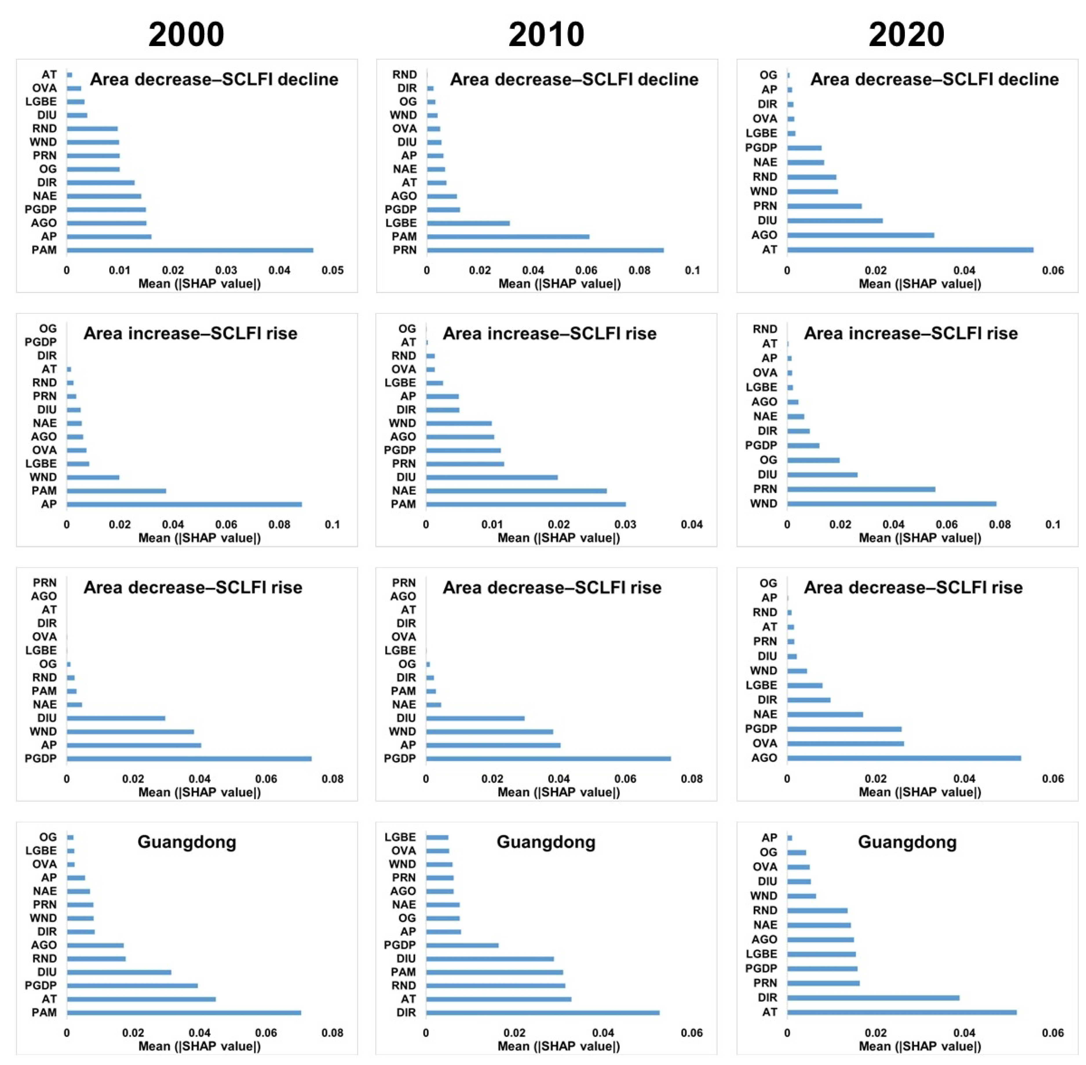
3.4. Drivers of Slope-Classified Cultivated Land Fragmentation
4. Discussion
4.1. Spatial Differentiation Characteristics of Slope of Cultivated Land
4.2. Divergent Drivers of Slope-Classified Cultivated Land Fragmentation
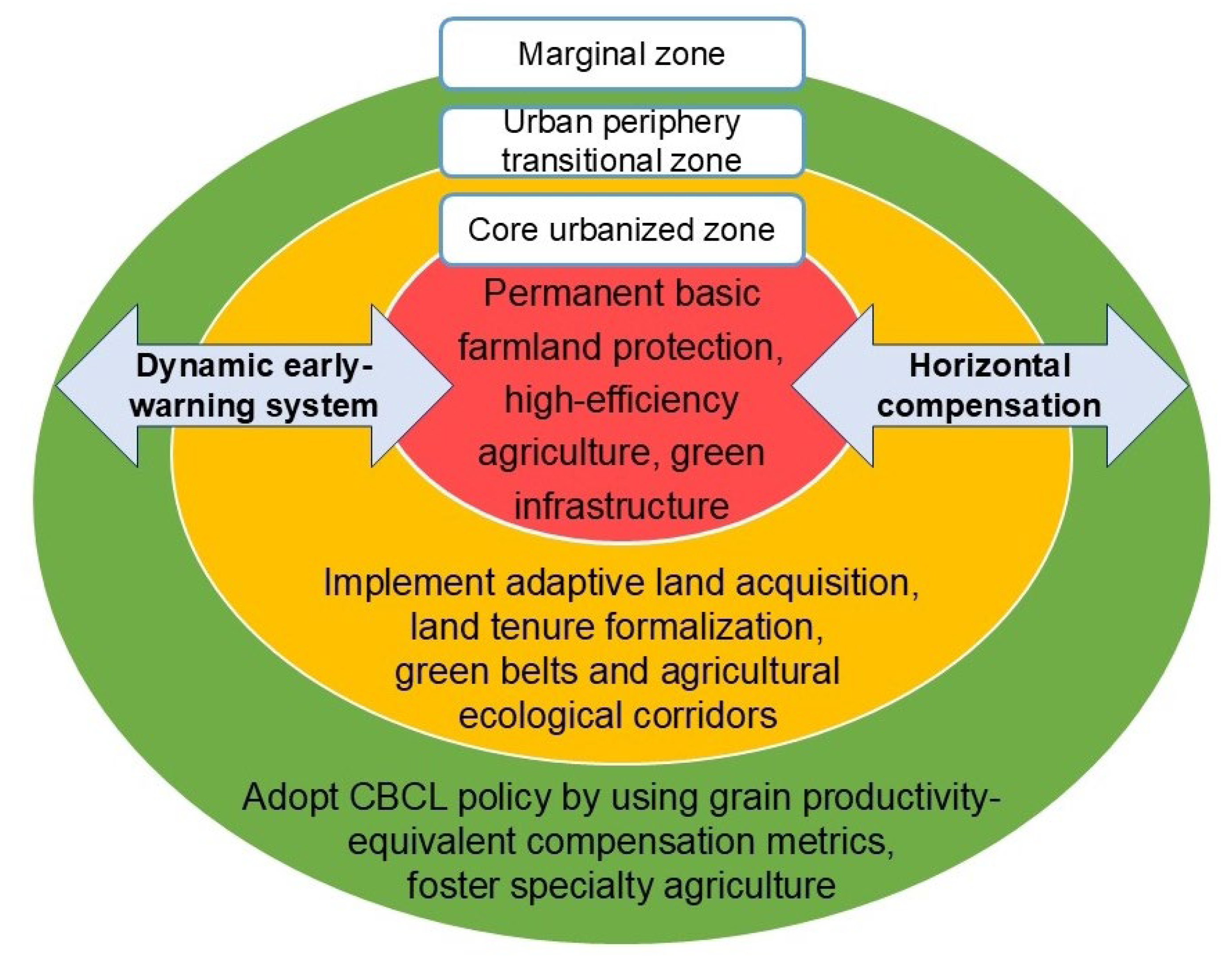
4.3. Implication for Differentiated Cultivated Land Protection
4.4. Contributions, Limitations, and Future Research Directions
5. Conclusions
Author Contributions
Funding
Data Availability Statement
Conflicts of Interest
References
- Kong, X. China must protect high-quality arable land. Nature 2014, 506, 7. [Google Scholar] [CrossRef]
- Chen, Y.; Yao, M.; Zhao, Q.; Chen, Z.; Jiang, P.; Li, M.; Chen, D. Delineation of a basic farmland protection zone based on spatial connectivity and comprehensive quality evaluation: A case study of Changsha City, China. Land Use Policy 2021, 101, 105145. [Google Scholar] [CrossRef]
- Cao, Y.; Zou, J.; Fang, X.; Wang, J.; Cao, Y.; Li, G. Effect of land tenure fragmentation on the decision-making and scale of agricultural land transfer in China. Land Use Policy 2020, 99, 104996. [Google Scholar] [CrossRef]
- Ciaian, P.; Guri, F.; Rajcaniova, M.; Drabik, D.; Paloma, S.G.Y. Land fragmentation and production diversification: A case study from rural Albania. Land Use Policy 2018, 76, 589–599. [Google Scholar] [CrossRef]
- Zhou, D.; Qi, J.; Yuan, C. Progress review and prospects for farmland fragmentation in China in the past 40 years. China Land Sci. 2021, 35, 107–116. [Google Scholar]
- Yang, Y.; Liu, Y.; Li, Y.; Li, J. Measure of urban-rural transformation in Beijing-Tianjin-Hebei region in the new millennium: Population-land-industry perspective. Land Use Policy 2018, 79, 595–608. [Google Scholar] [CrossRef]
- Yang, H.; Li, Y.; Han, X.; Zheng, D. Has land fragmentation increased the cost of agricultural production for “scale farmers”?: Based on micro surveys of 776 family farms and 1166 spacialized households across the country. China Land Sci. 2019, 33, 76–83. [Google Scholar]
- Qiu, L.; Zhu, J.; Pan, Y.; Wu, S.; Dang, Y.; Xu, B.; Yang, H. The positive impacts of landscape fragmentation on the diversification of agricultural production in Zhejiang Province, China. J. Clean. Prod. 2020, 251, 119722. [Google Scholar] [CrossRef]
- Sklenicka, P.; Janovska, V.; Salek, M.; Vlasak, J.; Molnarova, K. The Farmland Rental Paradox: Extreme land ownership fragmentation as a new form of land degradation. Land Use Policy 2014, 38, 587–593. [Google Scholar] [CrossRef]
- Zang, L.; Araral, E.; Wang, Y. Effects of land fragmentation on the governance of the commons: Theory and evidence from 284 villages and 17 provinces in China. Land Use Policy 2019, 82, 518–527. [Google Scholar] [CrossRef]
- Li, Q.; Jin, T.; Peng, Q.; Lin, J.; Zhang, D.; Huang, J.; Liu, B. Identifying the extent of the spatial expression of landscape fragmentation based on scale effect analysis in Southwest China. Ecol. Indic. 2022, 141, 109120. [Google Scholar] [CrossRef]
- Zhou, Y.; Li, X.; Liu, Y. Cultivated land protection and rational use in China. Land Use Policy 2021, 106, 105454. [Google Scholar] [CrossRef]
- Li, Y.; Wu, W.; Liu, Y. Land consolidation for rural sustainability in China: Practical reflections and policy implications. Land Use Policy 2018, 74, 137–141. [Google Scholar] [CrossRef]
- Liu, J.; Jin, X.; Xu, W.; Sun, R.; Han, B.; Yang, X.; Gu, Z.; Xu, C.; Sui, X.; Zhou, Y. Influential factors and classification of cultivated land fragmentation, and implications for future land consolidation: A case study of Jiangsu Province in eastern China. Land Use Policy 2019, 88, 104185. [Google Scholar] [CrossRef]
- Ntihinyurwa, P.D.; De Vries, W.T.; Chigbu, U.E.; Dukwiyimpuhwe, P.A. The positive impacts of farm land fragmentation in Rwanda. Land Use Policy 2019, 81, 565–581. [Google Scholar] [CrossRef]
- Han, P.; Xiang, J.; Zhao, Q. Spatial differentiation and scenario simulation of cultivated land in mountainous areas of Western Hubei, China: A PLUS model. Environ. Sci. Pollut. Res. 2023, 30, 52804–52817. [Google Scholar] [CrossRef]
- Xu, W.; Jin, X.; Liu, J.; Zhou, Y. Analysis of influencing factors of cultivated land fragmentation based on hierarchical linear model: A case study of Jiangsu Province, China. Land Use Policy 2021, 101, 105119. [Google Scholar] [CrossRef]
- Xu, W.; Jin, X.; Liu, J.; Zhou, Y. Impact of cultivated land fragmentation on spatial heterogeneity of agricultural agglomeration in China. J. Geogr. Sci. 2020, 30, 1571–1589. [Google Scholar] [CrossRef]
- Liang, J.; Pan, S.; Chen, W.; Li, J.; Zhou, T. Cultivated Land Fragmentation and Its Influencing Factors Detection: A Case Study in Huaihe River Basin, China. Int. J. Environ. Res. Public Health 2021, 19, 138. [Google Scholar] [CrossRef] [PubMed]
- Liu, J.; Jin, X.; Xu, W.; Zhou, Y. Evolution of cultivated land fragmentation and its driving mechanism in rural development: A case study of Jiangsu Province. J. Rural Stud. 2022, 91, 58–72. [Google Scholar] [CrossRef]
- Yu, Q.; Hu, Q.; Van Vliet, J.; Verburg, P.H.; Wu, W. GlobeLand30 shows little cropland area loss but greater fragmentation in China. Int. J. Appl. Earth Obs. Geoinf. 2018, 66, 37–45. [Google Scholar] [CrossRef]
- Jiang, P.; Chen, D.; Li, M. Farmland landscape fragmentation evolution and its driving mechanism from rural to urban: A case study of Changzhou City. J. Rural Stud. 2021, 82, 1–18. [Google Scholar] [CrossRef]
- Zhou, B.B.; Aggarwal, R.; Wu, J.; Lv, L. Urbanization-associated farmland loss: A macro-micro comparative study in China. Land Use Policy 2021, 101, 105228. [Google Scholar] [CrossRef]
- Zou, L.; Wang, J.; Bai, M. Assessing spatial–temporal heterogeneity of China’s landscape fragmentation in 1980–2020. Ecol. Indic. 2022, 136, 108654. [Google Scholar] [CrossRef]
- Latruffe, L.; Piet, L. Does land fragmentation affect farm performance? A case study from Brittany, France. Agric. Syst. 2014, 129, 68–80. [Google Scholar] [CrossRef]
- Ministry of Natural Resources. The Third National Land Resource Survey 2021. Available online: https://www.gov.cn/xinwen/2021-08/26/content_5633490.htm (accessed on 27 November 2024).
- Song, W.; Pijanowski, B.C. The effects of China’s cultivated land balance program on potential land productivity at a national scale. Appl. Geogr. 2014, 46, 158–170. [Google Scholar] [CrossRef]
- Du, X.; Zhang, X.; Jin, X. Assessing the effectiveness of land consolidation for improving agricultural productivity in China. Land Use Policy 2018, 70, 360–367. [Google Scholar] [CrossRef]
- Jin, R.; Li, B.; Zhou, T.; Wanatowski, D.; Piroozfar, P. An empirical study of perceptions towards construction and demolition waste recycling and reuse in China. Resour. Conserv. Recycl. 2017, 126, 86–98. [Google Scholar] [CrossRef]
- Su, M.; Sun, K.; Deng, B.; Cheng, N.; Cao, Y. Quantification and Driving Factors of Cultivated Land Fragmentation in Rapidly Urbanizing Area: A Case Study in Guangdong Province. Remote Sens. 2024, 16, 2633. [Google Scholar] [CrossRef]
- Guo, A.; Yue, W.; Yang, J.; Xue, B.; Xiao, W.; Li, M.; He, T.; Zhang, M.; Jin, X.; Zhou, Q. Cropland Abandonment in China: Patterns, Drivers, and Implications for Food Security. J. Clean. Prod. 2023, 418, 138154. [Google Scholar] [CrossRef]
- Yang, J.; Huang, X. The 30 m annual land cover dataset and its dynamics in China from 1990 to 2019. Earth Syst. Sci. Data 2021, 13, 3907–3925. [Google Scholar] [CrossRef]
- GB/T 21010-2017; Land use status classification. Standards Press of China: Beijing, China, 2017.
- Zhou, Y.; Chen, T.; Feng, Z.; Wu, K. Identifying the contradiction between the cultivated land fragmentation and the construction land expansion from the perspective of urban-rural differences. Ecol. Inform. 2022, 71, 101826. [Google Scholar] [CrossRef]
- Zhou, Y.; Xu, K.; Feng, Z.; Wu, K. Quantification and driving mechanism of cultivated land fragmentation under scale differences. Ecol. Inform. 2023, 78, 102336. [Google Scholar] [CrossRef]
- Diakoulaki, D.; Mavrotas, G.; Papayannakis, L. Determining objective weights in multiple criteria problems: The critic method. Comput. Oper. Res. 1995, 22, 763–770. [Google Scholar] [CrossRef]
- Zhao, Y.; Feng, Q.; Lu, A. Spatiotemporal variation in vegetation coverage and its driving factors in the Guanzhong Basin, NW China. Ecol. Inform. 2021, 64, 101371. [Google Scholar] [CrossRef]
- Li, Y.; Zhou, T.; Jiang, G.; Li, G.; Zhou, D.; Luo, Y. Spatial pattern and mechanisms of farmland abandonment in Agricultural and Pastoral Areas of Qingzang Plateau. Geogr. Sustain. 2021, 2, 139–150. [Google Scholar] [CrossRef]
- Deng, X.; Huang, J.; Rozelle, S.; Zhang, J.; Li, Z. Impact of urbanization on cultivated land changes in China. Land Use Policy 2015, 45, 1–7. [Google Scholar] [CrossRef]
- Tran, T.Q.; Vu, H.V. Land Fragmentation and Household Income: First Evidence from Rural Vietnam. Land Use Policy 2019, 89, 104247. [Google Scholar] [CrossRef]
- Sheng, J.; Han, X.; Zhou, H. Spatially varying patterns of afforestation/reforestation and socio-economic factors in China: A geographically weighted regression approach. J. Clean. Prod. 2017, 153, 362–371. [Google Scholar] [CrossRef]
- Chen, T.; Guestrin, C. XGBoost: A Scalable Tree Boosting System. In Proceedings of the 22nd ACM SIGKDD International Conference on Knowledge Discovery and Data Mining, San Francisco, CA, USA, 13–17 August 2016; pp. 785–794. [Google Scholar] [CrossRef]
- Lundberg, S.; Lee, S.I. A Unified Approach to Interpreting Model Predictions. arXiv 2017. [Google Scholar] [CrossRef]
- Jia, Y.; Chen, Z.; Lu, X.; Sheng, S.; Huang, J.; Wang, Y. The degradation and marginal effects of green space under the stress of urban sprawl in the metropolitan area. Urban For. Urban Green. 2024, 95, 128318. [Google Scholar] [CrossRef]
- Chen, Y.; Ma, W.; Shao, Y.; Wang, N.; Yu, Z.; Li, H.; Hu, Q. The impacts and thresholds detection of 2D/3D urban morphology on the heat island effects at the functional zone in megacity during heatwave event. Sustain. Cities Soc. 2025, 118, 106002. [Google Scholar] [CrossRef]
- Ke, X.; Van Vliet, J.; Zhou, T.; Verburg, P.H.; Zheng, W.; Liu, X. Direct and indirect loss of natural habitat due to built-up area expansion: A model-based analysis for the city of Wuhan, China. Land Use Policy 2018, 74, 231–239. [Google Scholar] [CrossRef]
- Zheng, W.; Ke, X.; Zhou, T.; Yang, B. Trade-offs between cropland quality and ecosystem services of marginal compensated cropland—A case study in Wuhan, China. Ecol. Indic. 2019, 105, 613–620. [Google Scholar] [CrossRef]
- Xu, M.; Niu, L.; Wang, X.; Zhang, Z. Evolution of farmland landscape fragmentation and its driving factors in the Beijing-Tianjin-Hebei region. J. Clean. Prod. 2023, 418, 138031. [Google Scholar] [CrossRef]
- Ge, D.; Long, H.; Qiao, W.; Wang, Z.; Sun, D.; Yang, R. Effects of rural–urban migration on agricultural transformation: A case of Yucheng City, China. J. Rural Stud. 2020, 76, 85–95. [Google Scholar] [CrossRef]
- Guo, G.; Ding, C. Quantitative research of the impact of land fragmentation on scale returns of grain production-based on empirical data of Yancheng City and Xuzhou City in Jiangsu Province. J. Nat. Resour. 2016, 31, 202–214. [Google Scholar]
- Ntihinyurwa, P.D.; De Vries, W.T. Farmland fragmentation and defragmentation nexus: Scoping the causes, impacts, and the conditions determining its management decisions. Ecol. Indic. 2020, 119, 106828. [Google Scholar] [CrossRef]
- Cao, Y.; Cao, Y.; Li, G.; Tian, Y.; Fang, X.; Li, Y.; Tan, Y. Linking ecosystem services trade-offs, bundles and hotspot identification with cropland management in the coastal Hangzhou Bay area of China. Land Use Policy 2020, 97, 104689. [Google Scholar] [CrossRef]

| Factor | Variable | Description | Unit | VIF |
|---|---|---|---|---|
| Natural factors | WND | Water network density of each county | km/km2 | 5.132 |
| AT | Average temperature of each county | °C | 1.913 | |
| AP | Annual precipitation of each county | mm | 2.245 | |
| Socioeconomic factors | OVA | Gross output value of agriculture of each county | 104 RMB | 3.539 |
| OG | Output of grain of each county | t | 5.390 | |
| AGO | Average grain output per mu in each county | kg/mu | 1.606 | |
| DIR | Per capita disposable income of rural households in each county | RMB | 7.245 | |
| PGDP | Per capita gross domestic product of each county | RMB | 2.685 | |
| DIU | Per capita disposable income of urban households in each county | RMB | 6.244 | |
| LGBE | Local government budgetary expenditure of each county | 104 RMB | 2.222 | |
| RND | Road network density of each county | km/km2 | 5.110 | |
| PAM | Total power of agricultural machinery of each county | kW | 3.075 | |
| Population | NAE | Number of agricultural employees in each county | / | 5.967 |
| PRN | Proportion of rural labor engaged in non-agricultural industries in each county | % | 2.311 |
| 2000 | 2010 | 2020 | ||||
|---|---|---|---|---|---|---|
| R2 | RMSE | R2 | RMSE | R2 | RMSE | |
| Area decrease–SCLFI decline | 0.619 | 0.145 | 0.773 | 0.070 | 0.658 | 0.078 |
| Area increase–SCLFI rise | 0.652 | 0.094 | 0.676 | 0.068 | 0.887 | 0.032 |
| Area decrease–SCLFI rise | 0.719 | 0.211 | 0.464 | 0.157 | 0.866 | 0.177 |
| Guangdong | 0.625 | 0.158 | 0.597 | 0.129 | 0.645 | 0.111 |
Disclaimer/Publisher’s Note: The statements, opinions and data contained in all publications are solely those of the individual author(s) and contributor(s) and not of MDPI and/or the editor(s). MDPI and/or the editor(s) disclaim responsibility for any injury to people or property resulting from any ideas, methods, instructions or products referred to in the content. |
© 2025 by the authors. Licensee MDPI, Basel, Switzerland. This article is an open access article distributed under the terms and conditions of the Creative Commons Attribution (CC BY) license (https://creativecommons.org/licenses/by/4.0/).
Share and Cite
Su, M.; Cheng, N.; Wang, Y.; Cao, Y. Spatiotemporal Evolution and Differentiated Spatial Governance of Slope-Classified Cultivated Land Fragmentation in Rapid Urbanization: Machine Learning-Driven Insights from Guangdong Province. Remote Sens. 2025, 17, 2855. https://doi.org/10.3390/rs17162855
Su M, Cheng N, Wang Y, Cao Y. Spatiotemporal Evolution and Differentiated Spatial Governance of Slope-Classified Cultivated Land Fragmentation in Rapid Urbanization: Machine Learning-Driven Insights from Guangdong Province. Remote Sensing. 2025; 17(16):2855. https://doi.org/10.3390/rs17162855
Chicago/Turabian StyleSu, Mengyuan, Nuo Cheng, Yajuan Wang, and Yu Cao. 2025. "Spatiotemporal Evolution and Differentiated Spatial Governance of Slope-Classified Cultivated Land Fragmentation in Rapid Urbanization: Machine Learning-Driven Insights from Guangdong Province" Remote Sensing 17, no. 16: 2855. https://doi.org/10.3390/rs17162855
APA StyleSu, M., Cheng, N., Wang, Y., & Cao, Y. (2025). Spatiotemporal Evolution and Differentiated Spatial Governance of Slope-Classified Cultivated Land Fragmentation in Rapid Urbanization: Machine Learning-Driven Insights from Guangdong Province. Remote Sensing, 17(16), 2855. https://doi.org/10.3390/rs17162855


