A Semi-Automated, Hybrid GIS-AI Approach to Seabed Boulder Detection Using High Resolution Multibeam Echosounder
Abstract
1. Introduction
2. Background Information
2.1. Boulder
2.2. Boulder Field
3. Materials and Methods
3.1. Methodological Considerations
3.1.1. Boulder
3.1.2. Boulder Field
3.1.3. Morphologies and Nomenclature
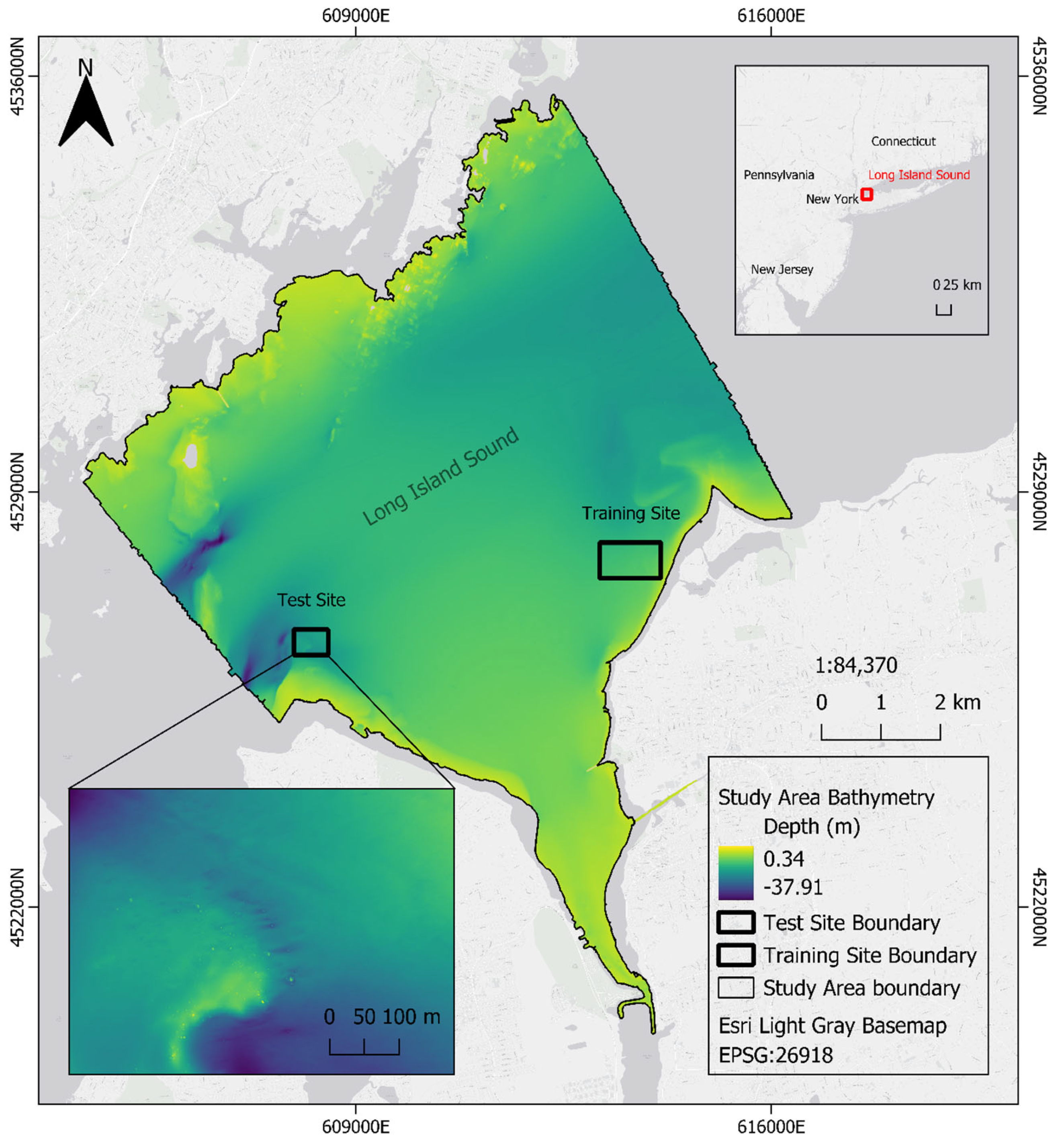
3.2. Study Area
3.2.1. Background Information and Regional Geology
3.2.2. Test Site
3.2.3. Training Site
3.3. Master Pick
3.4. Manual Pick
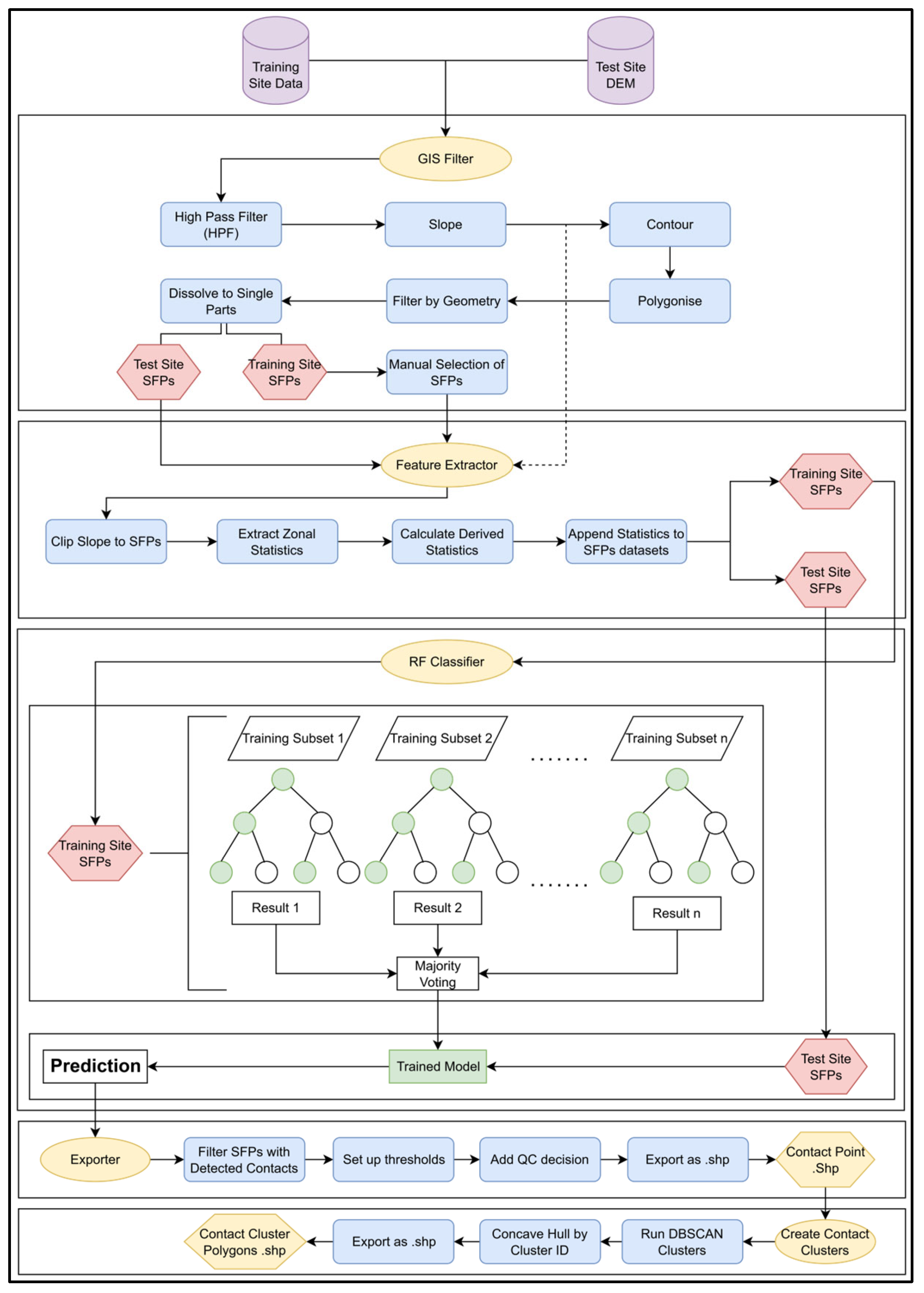
3.5. Semi-Automated Pick
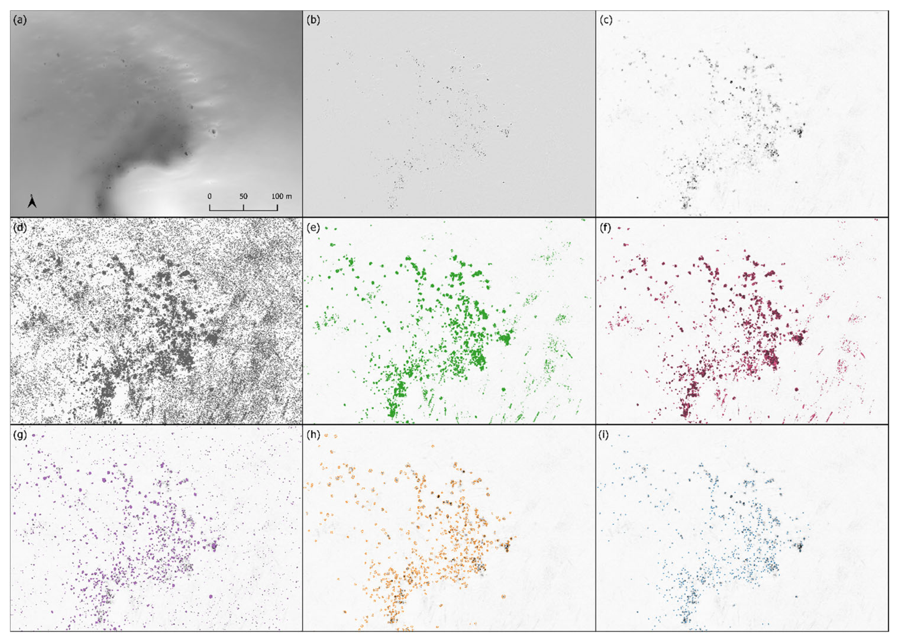
3.5.1. GIS Filter
3.5.2. Feature Extractor
3.5.3. RF Classifier
3.5.4. Exporter
3.5.5. Contact Clusters
3.6. Model Validation
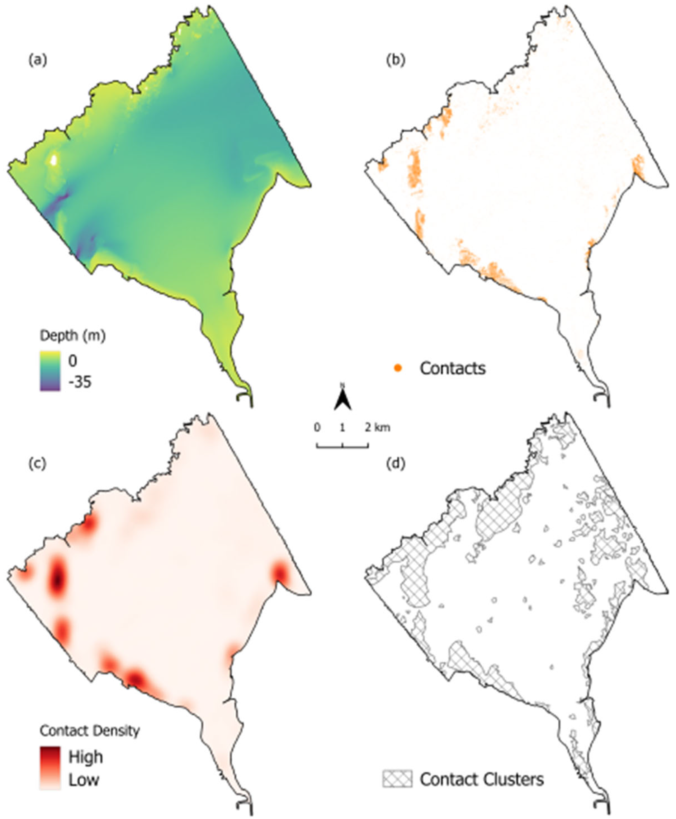
3.7. Semi-Automated Pick—Whole Study Area
4. Results
4.1. Master Pick
4.2. Manual Pick
4.3. Semi-Automated Pick
4.4. Results Comparison
4.5. Semi-Automated Pick—Whole Study Area
5. Discussion
5.1. Manual Picking Statistics
5.2. Algorithm Performance—Individual Contacts
5.3. Algorithm Performance—Comparison with Other Studies
5.4. Limitations and Future Work
6. Conclusions
Supplementary Materials
Author Contributions
Funding
Data Availability Statement
Acknowledgments
Conflicts of Interest
Abbreviations
| CNN | Convolutional Neural Network |
| CUBE | Combined Uncertainty Bathymetry Estimate |
| DBSCAN | Density-Based Spatial Clustering of Applications with Noise |
| DEM | Digital Elevation Model |
| EPSG | European Petroleum Survey Group |
| GDAL | Geospatial Data Abstraction Library |
| GIS | Geographical Information Systems |
| GNSS | Global Navigation Satellite System |
| GPS | Global Positioning System |
| HFP | High Pass Filter |
| ID | Identification |
| INFORMAR | Integrated Mapping for the Sustainable Development of Irelands Marine Resource |
| IPQ | Isoperimetric Quotient |
| LiDAR | Light Detection and Ranging |
| MBES | Multibeam Echo Sounder |
| ML | Machine Learning |
| MLLW | Mean Lower Low Water |
| NCEI | National Centers for Environmental Information |
| OBIA | Object-Based Image Analysis |
| OWE | Offshore Wind Energy |
| POS MV | Position and Orientation System for Marine Vessels |
| QC | Quality Control |
| RF | Random Forest |
| RV | Research Vessel |
| SFP | Semi-Filtered Polygon |
| SSS | Side Scan Sonar |
| USBL | Ultra-Short Baseline |
Appendix A
| Name | Description | Formula |
|---|---|---|
| Compactness | Quantifies how closely a shape approximates a perfect circle | |
| Variance | A measure of dispersion | |
| Mean | A measure of central tendency | |
| Skewness | A measure of Asymmetry | |
| Kurtosis | A measure of tailedness of a distribution | |
| Inter Quartile Range (IQR) | A measure of the spread of data | |
| Peak-to-Mean Ratio | A measure of variability | |
| Peak-Trough Difference | A measure of the spread of data | |
| Precision | Correct positives among predicted positives | |
| Recall | Correct positives among actual positives | |
| F1 | Correct classification among all instances |


References
- Peters, J.L.; Butschek, F.; O’Connell, R.; Cummins, V.; Murphy, J.; Wheeler, A.J. Geological seabed stability model for informing Irish offshore renewable energy opportunities. Adv. Geosci. 2020, 54, 55–65. [Google Scholar] [CrossRef]
- Wenau, S.; Schwarz, B.; Bihler, V.; Boyer, E.; Preu, B. Derisking offshore windfarm installation by sub-seafloor boulder detection based on dedicated seismic diffraction imaging. First Break 2022, 40, 41–45. [Google Scholar] [CrossRef]
- Nyberg, J.; Zillén-Snowball, L.; Strömstedt, E. Spatial characterization of seabed environmental conditions and geotechnical properties for the development of marine renewable energy in Sweden. Q. J. Eng. Geol. Hydrogeol. 2022, 55, qjegh2021-091. [Google Scholar] [CrossRef]
- Sutherland, J.L.; Davies, B.J.; Lee, J.R. A litho-tectonic event stratigraphy from dynamic Late Devensian ice flow of the North Sea Lobe, Tunstall, east Yorkshire, UK. Proc. Geol. Assoc. 2020, 131, 168–186. [Google Scholar] [CrossRef]
- Darvill, C.M.; Bentley, M.J.; Stokes, C.R. Geomorphology and weathering characteristics of erratic boulder trains on Tierra del Fuego, southernmost South America: Implications for dating of glacial deposits. Geomorphology 2015, 228, 382–397. [Google Scholar] [CrossRef]
- Goto, K.; Miyagi, K.; Kawamata, H.; Imamura, F. Discrimination of boulders deposited by tsunamis and storm waves at Ishigaki Island, Japan. Mar. Geol. 2010, 269, 34–45. [Google Scholar] [CrossRef]
- Feldens, A.; Marx, D.; Herbst, A.; Darr, A.; Papenmeier, S.; Hinz, M.; Feldens, P. Distribution of boulders in coastal waters of Western Pomerania, German Baltic Sea. Front. Earth Sci. 2023, 11, 1155765. [Google Scholar] [CrossRef]
- Franz, M.; von Rönn, G.A.; Barboza, F.R.; Karez, R.; Reimers, H.-C.; Schwarzer, K.; Wahl, M. How do geological structure and biological diversity relate? Benthic communities in boulder fields of the Southwestern Baltic Sea. Estuaries Coasts 2021, 44, 1994–2009. [Google Scholar] [CrossRef]
- European Commission DG Environment. Interpretation Manual of European Union Habitats, Version EUR28; European Commission DG Environment: Brussels, Belgium, 2013. [Google Scholar]
- Everingham, M.; Van Gool, L.; Williams, C.K.I.; Winn, J.; Zisserman, A. The PASCAL Visual Object Classes VOC Challenge. Int. J. Comput. Vis. 2010, 88, 303–338. [Google Scholar] [CrossRef]
- Aykut, N.O.; Akpınar, B.; Aydın, Ö. Hydrographic data modeling methods for determining precise seafloor topography. Comput. Geosci. 2013, 17, 661–669. [Google Scholar] [CrossRef]
- Micallef, A.; Le Bas, T.P.; Huvenne, V.A.; Blondel, P.; Hühnerbach, V.; Deidun, A. A multi-method approach for benthic habitat mapping of shallow coastal areas with high-resolution multibeam data. Cont. Shelf Res. 2012, 39, 14–26. [Google Scholar] [CrossRef]
- Pearce, B.; Fariñas-Franco, J.M.; Wilson, C.; Pitts, J.; deBurgh, A.; Somerfield, P.J. Repeated mapping of reefs constructed by Sabellaria spinulosa Leuckart 1849 at an offshore wind farm site. Cont. Shelf Res. 2014, 83, 3–13. [Google Scholar] [CrossRef]
- Majcher, J.; Plets, R.; Quinn, R. Residual relief modelling: Digital elevation enhancement for shipwreck site characterisation. Archaeol. Anthropol. Sci. 2020, 12, 6. [Google Scholar] [CrossRef]
- Lamarche, G.; Lurton, X. Recommendations for improved and coherent acquisition and processing of backscatter data from seafloor-mapping sonars. Mar. Geophys. Res. 2018, 39, 5–22. [Google Scholar] [CrossRef]
- Zhang, F.; Zhang, W.; Cheng, C.; Hou, X.; Cao, C. Detection of small objects in side-scan sonar images using an enhanced YOLOv7-based approach. J. Mar. Sci. Eng. 2023, 11, 2155. [Google Scholar] [CrossRef]
- Feldens, P.; Darr, A.; Feldens, A.; Tauber, F. Detection of boulders in side scan sonar mosaics by a neural network. Geosciences 2019, 9, 159. [Google Scholar] [CrossRef]
- Luo, Q.; Yan, X.; Ju, C.; Chen, Y.; Luo, Z. An ultra-short baseline underwater positioning system with Kalman filtering. Sensors 2021, 21, 143. [Google Scholar] [CrossRef]
- Guinan, J.; McKeon, C.; O’Keeffe, E.; Monteys, X.; Sacchetti, F.; Coughlan, M.; Nic Aonghusa, C. INFOMAR data in the EMODnet Geology data portal supports marine spatial planning and offshore energy development in the Irish offshore. Q. J. Eng. Geol. Hydrogeol. 2020, 54, qjegh2020-033. [Google Scholar] [CrossRef]
- National Centers for Environmental Information (NCEI). NOAA Bathymetry Viewer. Available online: https://www.ncei.noaa.gov/maps/bathymetry/?layers=multibeam (accessed on 20 February 2025).
- Summers, G.; Lim, A.; Wheeler, A.J. A scalable, supervised classification of seabed sediment waves using an object-based image analysis approach. Remote Sens. 2021, 13, 2317. [Google Scholar] [CrossRef]
- Peters, J.L.; Wheeler, A.J.; Cummins, V. Data Resources Assessment—Phase 2. In EirWind Project Deliverable D2.1 Report; MaREI Centre, ERI, University College Cork: Cork, Ireland, 2019. [Google Scholar] [CrossRef]
- Peters, J.L.; Remmers, T.; Wheeler, A.J.; Murphy, J.; Cummins, V. A systematic review and meta-analysis of GIS use to reveal trends in offshore wind energy research and offer insights on best practices. Renew. Sustain. Energy Rev. 2020, 128, 109916. [Google Scholar] [CrossRef]
- Ierodiaconou, D.; Schimel, A.C.G.; Kennedy, D.; Monk, J.; Gaylard, G.; Young, M.; Diesing, M.; Rattray, A. Combining pixel and object-based image analysis of ultra-high resolution multibeam bathymetry and backscatter for habitat mapping in shallow marine waters. Mar. Geophys. Res. 2018, 39, 271–288. [Google Scholar] [CrossRef]
- Janowski, L.; Wroblewski, R.; Dworniczak, J.; Kolakowski, M.; Rogowska, K.; Wojcik, M.; Gajewski, J. Offshore benthic habitat mapping based on object-based image analysis and geomorphometric approach: A case study from the Slupsk Bank, Southern Baltic Sea. Sci. Total Environ. 2021, 801, 149712. [Google Scholar] [CrossRef]
- Arosio, R.; Hobley, B.; Wheeler, A.J.; Sacchetti, F.; Conti, L.A.; Furey, T.; Lim, A. Fully convolutional neural networks applied to large-scale marine morphology mapping. Front. Mar. Sci. 2023, 10, 1228867. [Google Scholar] [CrossRef]
- Verfaillie, E.; Doornenbal, P.; Mitchell, A.J.; White, J.; Van Lancker, V. The Bathymetric Position Index (BPI) as a Support Tool for Habitat Mapping: Worked Example for the MESH Final Guidance; MESH Project, Marine Institute: Galway, Ireland, 2007; p. 14. [Google Scholar]
- Walbridge, S.; Slocum, N.; Pobuda, M.; Wright, D.J. Unified geomorphological analysis workflows with Benthic Terrain Modeler. Geosciences 2018, 8, 94. [Google Scholar] [CrossRef]
- Wessel, P. An empirical method for optimal robust regional-residual separation of geophysical data. Math. Geol. 1998, 30, 391–408. [Google Scholar] [CrossRef]
- Gafeira, J.; Dolan, M.F.J.; Monteys, X. Geomorphometric characterization of pockmarks by using a GIS-based semi-automated toolbox. Geosciences 2018, 8, 154. [Google Scholar] [CrossRef]
- Hansen, S.S.; Ernstsen, V.B.; Andersen, M.S.; Al-Hamdani, Z.; Baran, R.; Niederwieser, M.; Steinbacher, F.; Kroon, A. Classification of boulders in coastal environments using random forest machine learning on topo-bathymetric LiDAR data. Remote Sens. 2021, 13, 4101. [Google Scholar] [CrossRef]
- Hinz, M.; Olberg, D.; Schlenz, B.; Schmitt, T. AI-based boulder detection in sonar data—Bridging the gap from experimentation to application. Int. Hydrogr. Rev. 2024, 25, 45–58. [Google Scholar] [CrossRef]
- Nichols, G. Sedimentology and Stratigraphy, 2nd ed.; Wiley-Blackwell: Chichester, UK, 2010. [Google Scholar]
- Wentworth, C.K. A scale of grade and class terms for clastic sediments. J. Geol. 1922, 30, 377–392. [Google Scholar] [CrossRef]
- Feldens, P. Super resolution by deep learning improves boulder detection in side scan sonar backscatter mosaics. Remote Sens. 2020, 12, 2284. [Google Scholar] [CrossRef]
- Kleman, J. Preservation of landforms under ice sheets and ice caps. Geomorphology 1994, 9, 19–32. [Google Scholar] [CrossRef]
- Pittman, J.; Griffiths, S.; Guigné, J.Y. Near surface sub-seabed boulder detection using a 3D acoustic profiler. In Proceedings of the 9th Offshore Site Investigation and Geotechnics (OSIG) Conference, London, UK, 12 September 2023. [Google Scholar]
- Mason, R.J.; Polvi, L.E. How big is a boulder? The importance of boulder definition choice in earth science research and river management. Earth Surf. Process. Landf. 2024, 49, 2840–2854. [Google Scholar] [CrossRef]
- National Centers for Environmental Information (NCEI). Hydrographic Survey H13385. Available online: https://www.ngdc.noaa.gov/nos/H12001-H14000/H13385.html (accessed on 20 February 2025).
- Young, R.A.; Gordon, L.M.; Owen, L.A.; Huot, S.; Zerfas, T.D. Evidence for a late glacial advance near the beginning of the Younger Dryas in western New York State: An event postdating the record for local Laurentide ice sheet recession. Geosphere 2020, 17, 271–305. [Google Scholar] [CrossRef]
- Margold, M.; Stokes, C.R.; Clark, C.D. Reconciling records of ice streaming and ice margin retreat to produce a palaeogeographic reconstruction of the deglaciation of the Laurentide Ice Sheet. Quat. Sci. Rev. 2018, 189, 1–30. [Google Scholar] [CrossRef]
- Weiss, A.D. Topographic position and landforms analysis. In Proceedings of the 2001 ESRI User Conference, San Diego, CA, USA, 9–13 July 2001. [Google Scholar]
- Polsby, D.D.; Popper, R.D. The third criterion: Compactness as a procedural safeguard against partisan gerrymandering. Yale Law Policy Rev. 1991, 9, 301–353. [Google Scholar] [CrossRef]
- Cox, E.P. A method of assigning numerical and percentage values to the degree of roundness of sand grains. J. Paleontol. 1927, 1, 179–183. [Google Scholar]
- Breiman, L. Random forests. Mach. Learn. 2001, 45, 5–32. [Google Scholar] [CrossRef]
- Pedregosa, F.; Varoquaux, G.; Gramfort, A.; Michel, V.; Thirion, B.; Grisel, O.; Blondel, M.; Prettenhofer, P.; Weiss, R.; Dubourg, V.; et al. Scikit-learn: Machine learning in Python. J. Mach. Learn. Res. 2011, 12, 2825–2830. [Google Scholar]
- Chen, W.; Xie, X.; Wang, J.; Pradhan, B.; Hong, H.; Bui, D.T.; Duan, Z.; Ma, J. A comparative study of logistic model tree, random forest, and classification and regression tree models for spatial prediction of landslide susceptibility. Catena 2017, 151, 147–160. [Google Scholar] [CrossRef]
- Belgiu, M.; Drăguț, L. Random forest in remote sensing: A review of applications and future directions. ISPRS J. Photogramm. Remote Sens. 2016, 114, 24–31. [Google Scholar] [CrossRef]
- Rodriguez-Galiano, V.F.; Ghimire, B.; Rogan, J.; Chica-Olmo, M.; Rigol-Sanchez, J.P. An assessment of the effectiveness of a random forest classifier for land-cover classification. ISPRS J. Photogramm. Remote Sens. 2012, 67, 93–104. [Google Scholar] [CrossRef]
- Cutler, D.R.; Edwards, T.C.; Beard, K.H.; Cutler, A.; Hess, K.T.; Gibson, J.; Lawler, J.J. Random forests for classification in ecology. Ecology 2007, 88, 2783–2792. [Google Scholar] [CrossRef] [PubMed]
- Probst, P.; Boulesteix, A.-L.; Bischl, B. Tunability: Importance of hyperparameters of machine learning algorithms. WIREs Data Min. Knowl. Discov. 2019, 9, e1301. [Google Scholar] [CrossRef]
- Grinsztajn, L.; Oyallon, E.; Varoquaux, G. Why do tree-based models still outperform deep learning on typical tabular data? In Proceedings of the 35th Conference on Neural Information Processing Systems (NeurIPS 2022), New Orleans, LA, USA, 28 November–9 December 2022. [Google Scholar] [CrossRef]
- Farris, F.A. The Gini index and measures of inequality. Am. Math. Mon. 2010, 117, 851–864. [Google Scholar] [CrossRef]
- Ester, M.; Kriegel, H.-P.; Sander, J.; Xu, X. A density-based algorithm for discovering clusters in large spatial databases with noise. In Proceedings of the Second International Conference on Knowledge Discovery and Data Mining (KDD ’96), Portland, OR, USA, 2–4 August 1996; AAAI Press: Menlo Park, CA, USA, 1996; pp. 226–231. [Google Scholar]
- Kohavi, R. A study of cross-validation and bootstrap for accuracy estimation and model selection. In Proceedings of the 14th International Joint Conference on Artificial Intelligence (IJCAI ’95), Portland, OR, USA, 2–4 August 1995; Morgan Kaufmann: San Mateo, CA, USA, 1995; Volume 2, pp. 1137–1143. [Google Scholar]
- Van Rijsbergen, C.J. Information Retrieval, 2nd ed.; Butterworth-Heinemann: London, UK, 1979. [Google Scholar]
- Russakovsky, O.; Deng, J.; Su, H.; Krause, J.; Satheesh, S.; Ma, S.; Huang, Z.; Karpathy, A.; Khosla, A.; Bernstein, M.; et al. ImageNet large scale visual recognition challenge. Int. J. Comput. Vis. 2015, 115, 211–252. [Google Scholar] [CrossRef]
- International Hydrographic Organization (IHO). IHO Standards for Hydrographic Surveys, S-44, 6th ed.; Version 6.1.0; International Hydrographic Bureau: Monaco, 2023; Available online: https://iho.int/uploads/user/pubs/standards/s-44/S-44_Edition_6.1.0.pdf (accessed on 2 March 2025).
- South Fork Wind. Ørsted: Discover NY’s First Offshore Wind Farm. Available online: https://southforkwind.com (accessed on 26 February 2025).
- Empire Wind. Empire Wind: Powering New York’s Future. Available online: https://www.empirewind.com (accessed on 12 February 2025).
- Sunrise Wind. Sunrise Wind: A Partnership for Clean Energy. Available online: https://sunrisewindny.com (accessed on 12 February 2025).
- Fletcher, T.; Booth, M.T.; Pritt, J.J. A comparison of recreational and survey-grade side-scan sonar systems in mapping reservoir fish habitat. N. Am. J. Fish. Manag. 2024, 44, 1422–1438. [Google Scholar] [CrossRef]
- Gonzalez-Socoloske, D.; Olivera-Gomez, L.D. Gentle giants in dark waters: Using side-scan sonar for manatee research. Open Remote Sens. J. 2012, 5, 1–14. [Google Scholar] [CrossRef]
- Daugherty, D.J.; Fleming, B.P. Effects of training on side-scan sonar use as a fish survey tool: A case study in alligator gar. J. Fish Wildl. Manag. 2021, 12, 152–163. [Google Scholar] [CrossRef]
- Van Unen, P.; Lekkerkerk, H.-J. Machine Learning as a Tool: Detecting Boulders in a Multibeam Point Cloud. Hydro Int. 2021. Available online: https://www.hydro-international.com/content/article/machine-learning-as-a-tool (accessed on 18 March 2025).
- Blondel, P. The Handbook of Sidescan Sonar; Springer: Berlin/Heidelberg, Germany, 2009; p. 316. [Google Scholar] [CrossRef]
- Feldens, P.; Schmidt, V.; Held, P.; Wilken, D. Automatic detection of boulders by neural networks: A comparison of multibeam echo sounder and side-scan sonar performance. Hydrogr. Nachr. 2021, 119, 6–11. [Google Scholar] [CrossRef]
- Janowski, Ł. Advancing seabed bedform mapping in the Kuźnica Deep: Leveraging multibeam echosounders and machine learning for enhanced underwater landscape analysis. Remote Sens. 2025, 17, 373. [Google Scholar] [CrossRef]
- Kira, K.; Rendell, L.A. A practical approach to feature selection. In Machine Learning Proceedings 1992; Sleeman, D., Edwards, P., Eds.; Morgan Kaufmann: Burlington, MA, USA, 1992; pp. 249–256. [Google Scholar] [CrossRef]
- Pols, C.T.; Sturt, F.; El Safadi, C.; Marcu, A. Shipwreck detection in bathymetry data using semi-automated methods: Combining machine learning and topographic inference approaches. J. Archaeol. Sci. 2025, 181, 106297. [Google Scholar] [CrossRef]
- Dowah, H.; Kirawan, K. Automated Boulder Localization and Recognition in Side-Scan Sonar Data Using Deep Learning. Master’s Thesis, Blekinge Institute of Technology, Karlskrona, Sweden, 2025. [Google Scholar]
| Name | No. Contacts | TP | FP | Recall | Precision | F1-Score |
|---|---|---|---|---|---|---|
| Master | 613 | 613 | 0 | 100 | 100 | 100 |
| Algo | 749 | 506 | 243 | 83 | 68 | 74 |
| Algo with QC | 696 | 507 | 189 | 83 | 73 | 77 |
| Picker 1 | 516 | 309 | 207 | 50 | 60 | 55 |
| Picker 2 | 466 | 434 | 32 | 71 | 93 | 80 |
| Picker 3 | 545 | 460 | 85 | 75 | 84 | 79 |
| Picker 4 | 792 | 574 | 218 | 94 | 72 | 82 |
| Picker 5 | 439 | 417 | 22 | 68 | 95 | 79 |
| Picker 6 | 537 | 478 | 59 | 78 | 89 | 83 |
| Standard Deviation | 128 | 95 | 98 | 16 | 14 | 12 |
| Manual Pick Average | 549 | 445 | 104 | 73 | 82 | 76 |
Disclaimer/Publisher’s Note: The statements, opinions and data contained in all publications are solely those of the individual author(s) and contributor(s) and not of MDPI and/or the editor(s). MDPI and/or the editor(s) disclaim responsibility for any injury to people or property resulting from any ideas, methods, instructions or products referred to in the content. |
© 2025 by the authors. Licensee MDPI, Basel, Switzerland. This article is an open access article distributed under the terms and conditions of the Creative Commons Attribution (CC BY) license (https://creativecommons.org/licenses/by/4.0/).
Share and Cite
Downing, E.; O’Reilly, L.; Majcher, J.; O’Mahony, E.; Peters, J. A Semi-Automated, Hybrid GIS-AI Approach to Seabed Boulder Detection Using High Resolution Multibeam Echosounder. Remote Sens. 2025, 17, 2711. https://doi.org/10.3390/rs17152711
Downing E, O’Reilly L, Majcher J, O’Mahony E, Peters J. A Semi-Automated, Hybrid GIS-AI Approach to Seabed Boulder Detection Using High Resolution Multibeam Echosounder. Remote Sensing. 2025; 17(15):2711. https://doi.org/10.3390/rs17152711
Chicago/Turabian StyleDowning, Eoin, Luke O’Reilly, Jan Majcher, Evan O’Mahony, and Jared Peters. 2025. "A Semi-Automated, Hybrid GIS-AI Approach to Seabed Boulder Detection Using High Resolution Multibeam Echosounder" Remote Sensing 17, no. 15: 2711. https://doi.org/10.3390/rs17152711
APA StyleDowning, E., O’Reilly, L., Majcher, J., O’Mahony, E., & Peters, J. (2025). A Semi-Automated, Hybrid GIS-AI Approach to Seabed Boulder Detection Using High Resolution Multibeam Echosounder. Remote Sensing, 17(15), 2711. https://doi.org/10.3390/rs17152711


