A Soil Moisture-Informed Seismic Landslide Model Using SMAP Satellite Data
Abstract
1. Introduction
2. Materials and Methods
2.1. Landslide Inventories
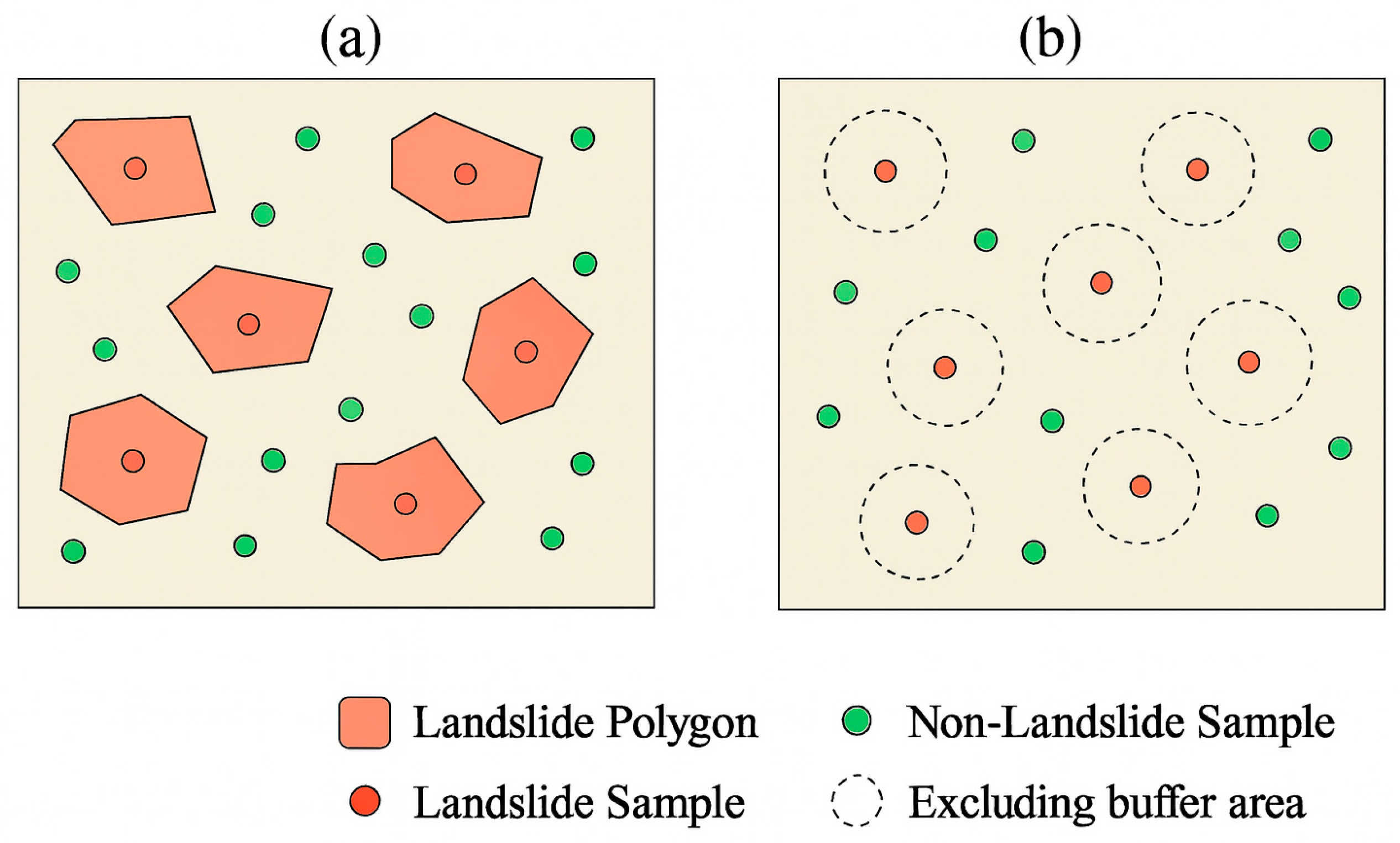
2.2. Landslide and Non-Landslide Data Sampling
2.3. Key Variables
- (1)
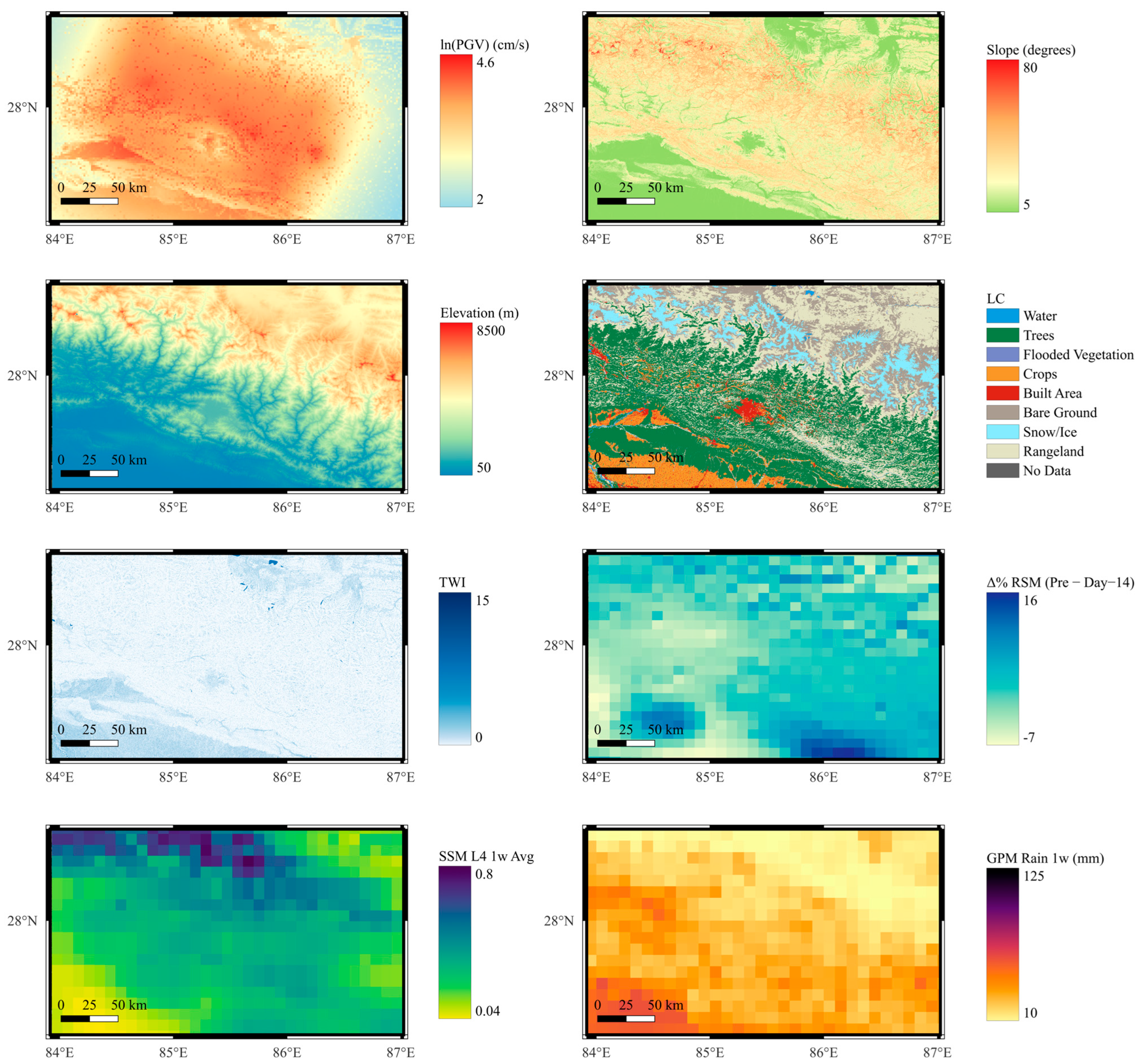
- Prior-event Normalized Soil Moisture: Averages of Root Zone Soil Moisture (RSM), Level 4 Surface Soil Moisture (SSM L4), and Level 3 Surface Soil Moisture (SSM L3) were computed over multiple pre-event windows (1 month, 2 weeks, 1 week, and 3 days). Due to temporal resolution limitations, a 3-day average was not computed for Level 3. In addition to antecedent conditions, RSM and SSM L4 values were also extracted for the day of the earthquake to represent modeled soil moisture at the time of shaking. For SMAP L3, the nearest-available value was used when event-day data were unavailable due to its coarser temporal sampling schedule. Each soil moisture value, whether from antecedent or event-day windows, was normalized using the annual minimum and maximum soil moisture values for the corresponding earthquake year, following:where is soil moisture value, and and represent the minimum and maximum annual values. These normalized metrics characterize relative wetness conditions and baseline soil saturation across different periods prior to each earthquake, which can influence pore pressure buildup and slope strength over time.
- (2)
- Short-Term Soil Moisture Change: These variables quantify the percentage change in soil moisture over short-term periods leading up to the earthquake, specifically for Root Zone Soil Moisture (RSM) and Level 4 Surface Soil Moisture (SSM L4). The change is calculated between the 3-day average prior to the event and longer-term antecedent averages (1 month and 2 weeks), as well as between the event-day value and the 1-week average. These variables assess whether soils were experiencing anomalous wetting or drying prior to failure and destabilizing conditions such as post-rainfall infiltration, offering insight into potential triggering mechanisms.
- (3)
- Lagged Soil Moisture Change: Percent differences in Root Zone Soil Moisture (RSM) and Level 4 Surface Soil Moisture (SSM L4) were computed between event-day values and those recorded at lagged time steps (e.g., 3, 7, 10, and 14 days before the earthquake). These changes capture the short-term evolution of soil moisture, allowing detection of rapid wetting or drying trends that may not be evident in longer-term averages. Such variations can help identify transient hydrologic conditions conducive to slope failure under seismic loading.
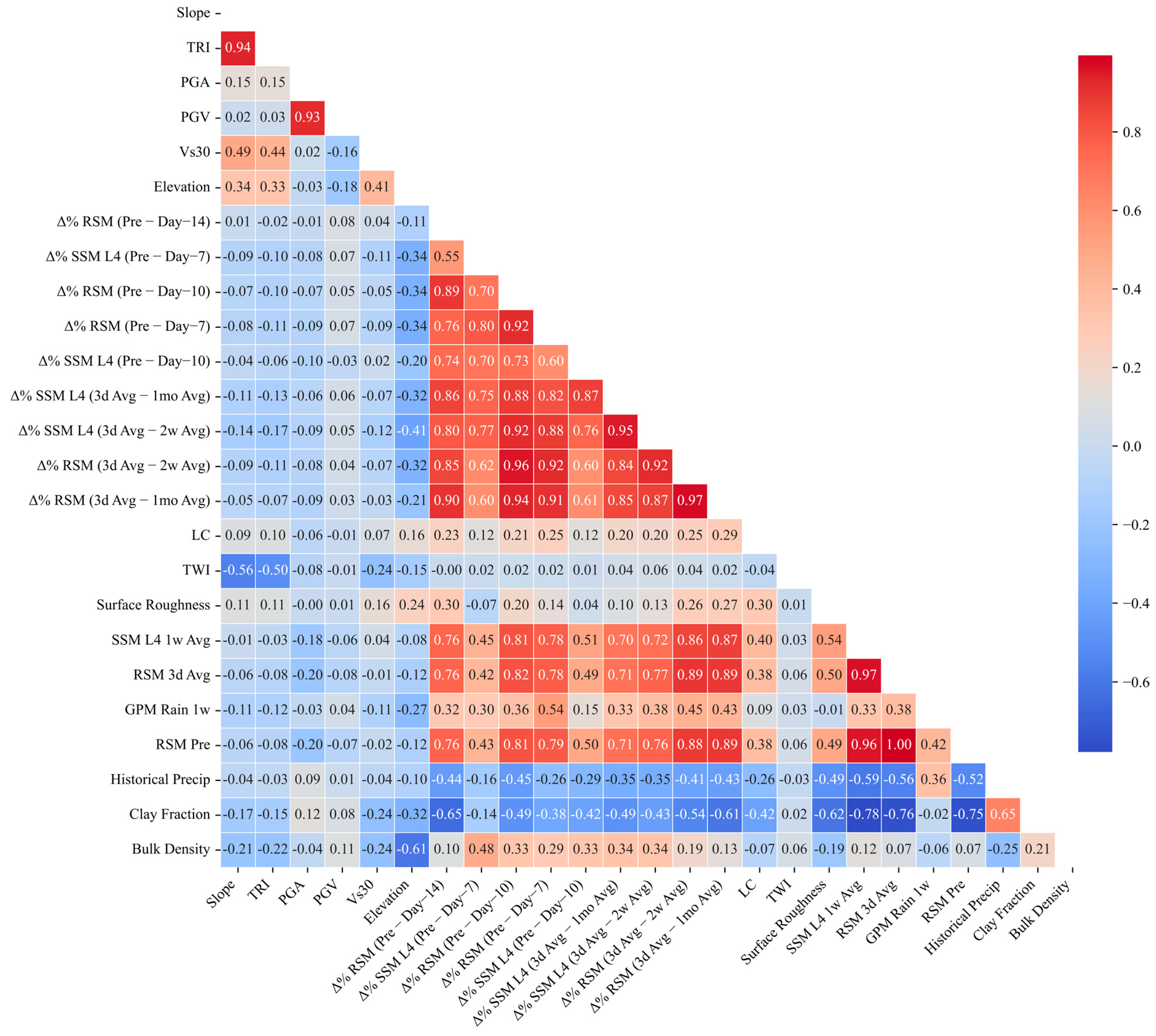
2.4. Independent Variable Selection and Multicollinearity Test
2.5. Model Development
- : Overall proportion of correctly classified instances.
- : Proportion of predicted landslides that are true landslides.
- Sensitivity): Proportion of actual landslides correctly identified.
- : Harmonic mean of precision and recall, balancing both metrics.
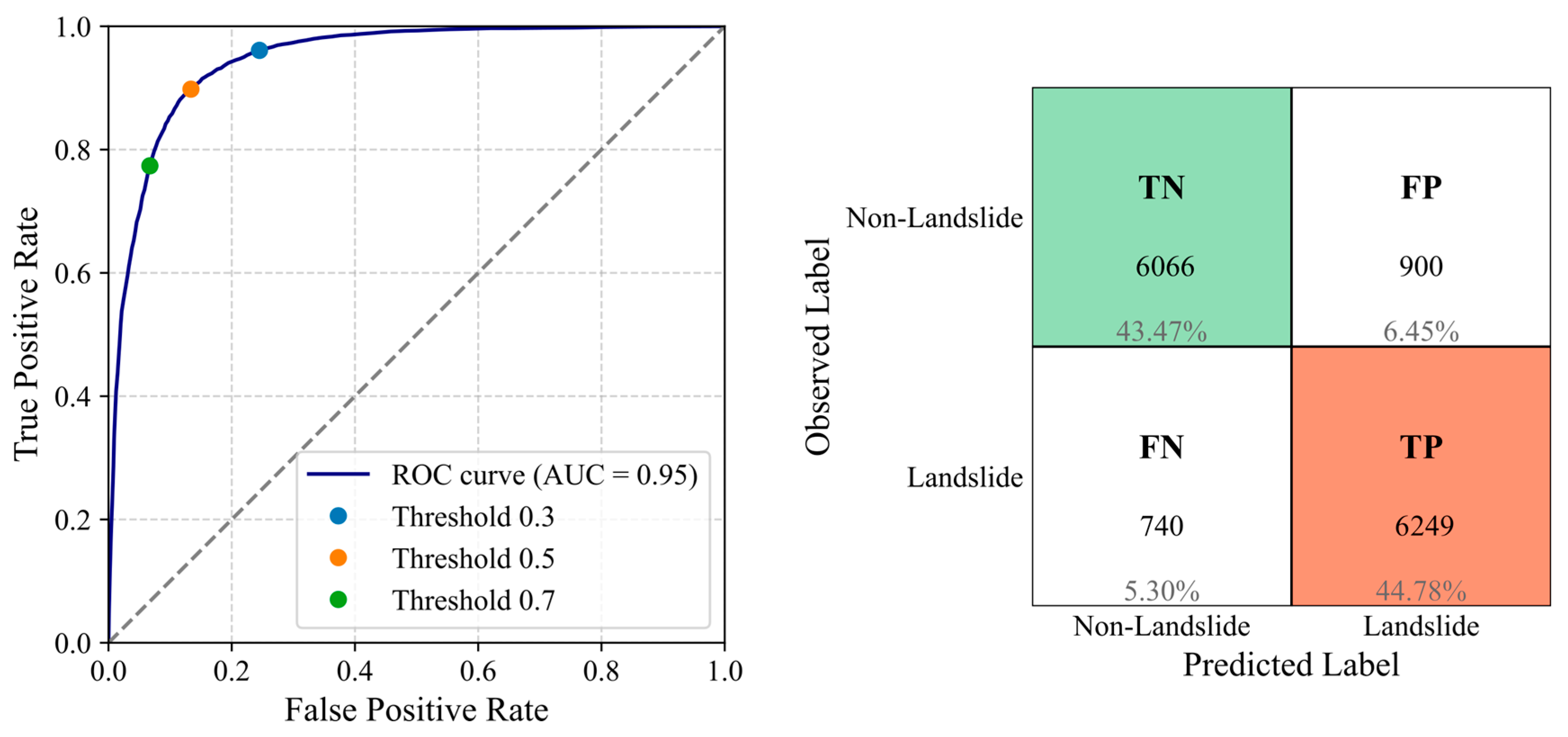
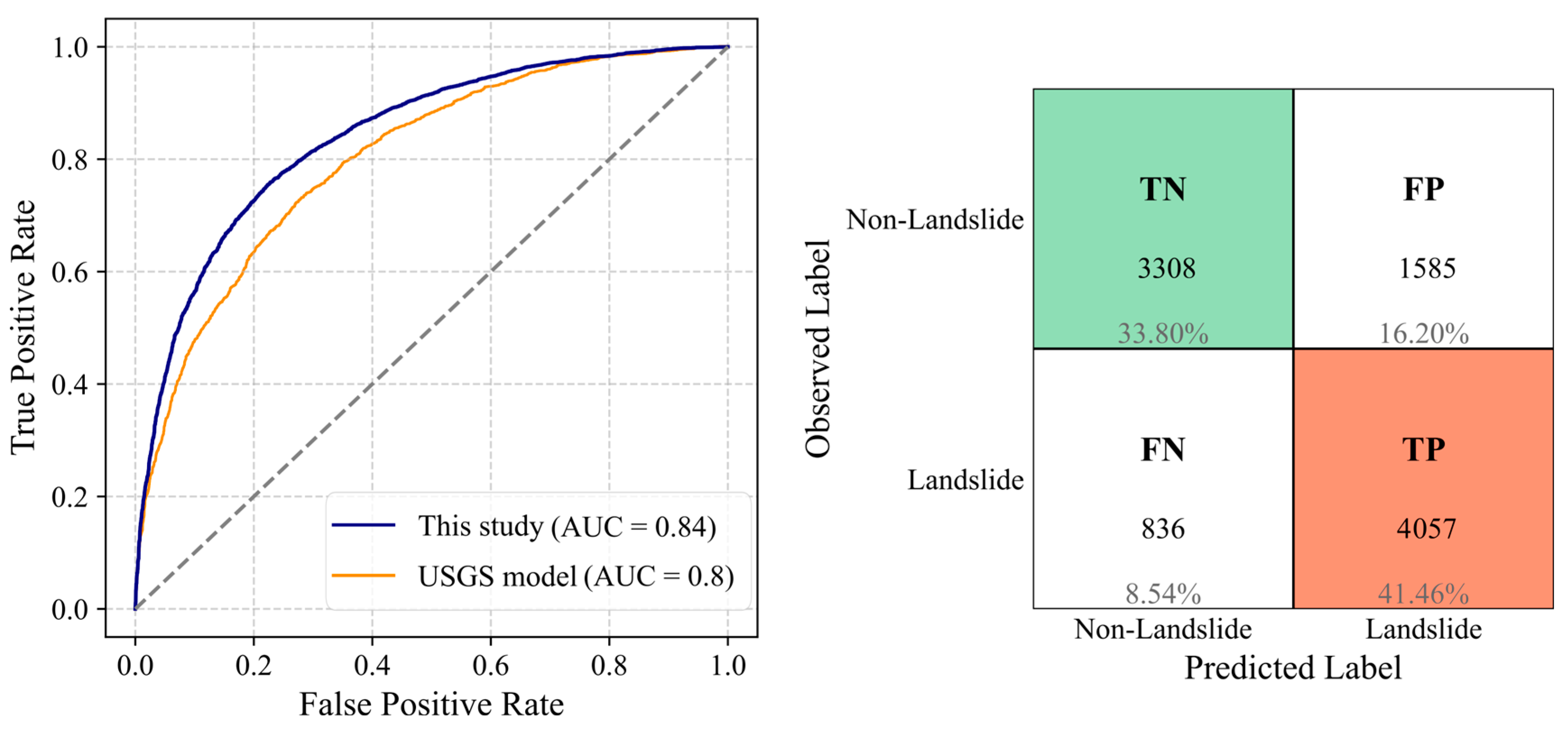
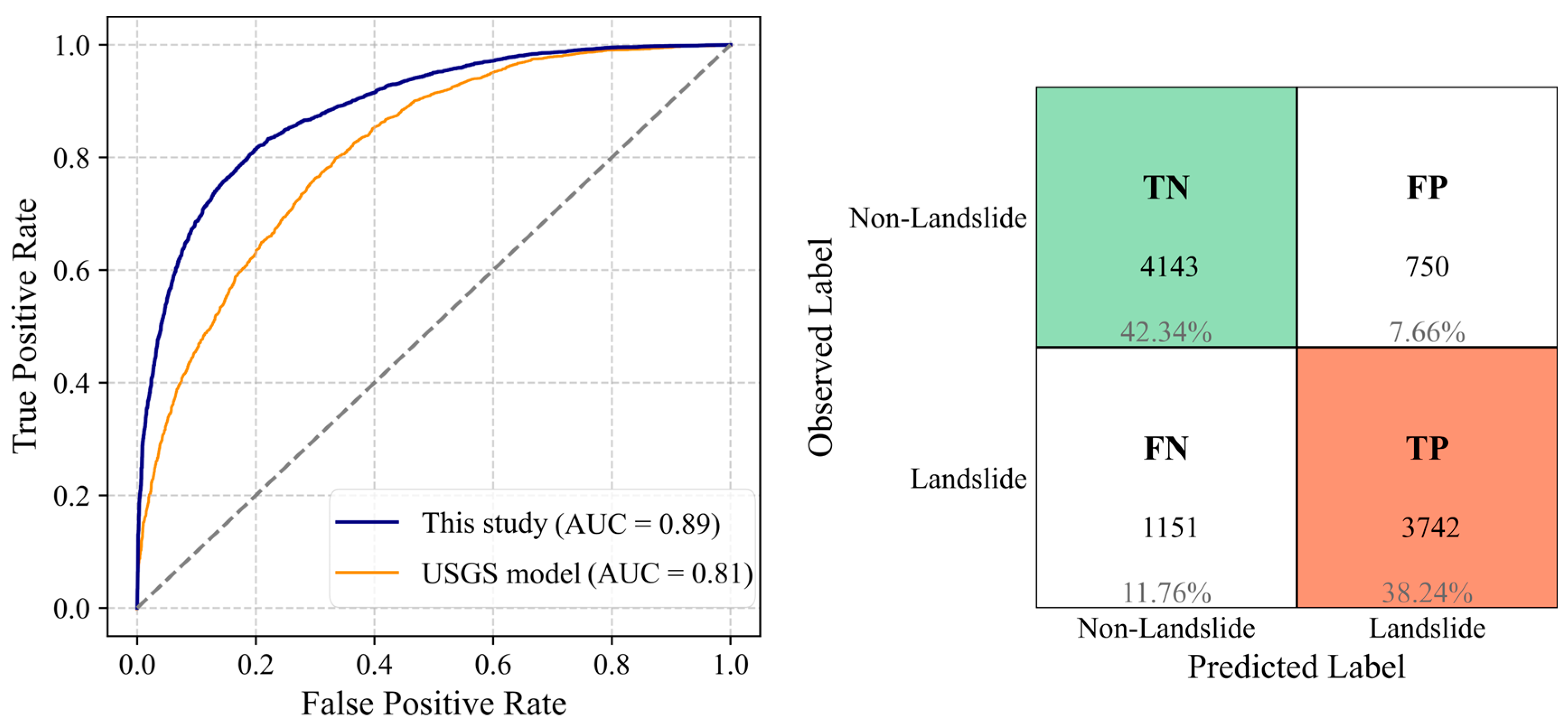
- AUC (Area Under the ROC Curve): The ROC (Receiver Operating Characteristic) curve plots the true positive rate (TPR)—the proportion of landslide cases correctly classified as landslides by the model—against the false positive rate (FPR)—the proportion of non-landslide cases incorrectly classified as landslides—across various classification thresholds. The AUC summarizes this curve into a single value, representing the model’s ability to distinguish between classes independently of any fixed threshold.
2.6. Assessment of Model Uncertainty and Reliability
3. Results
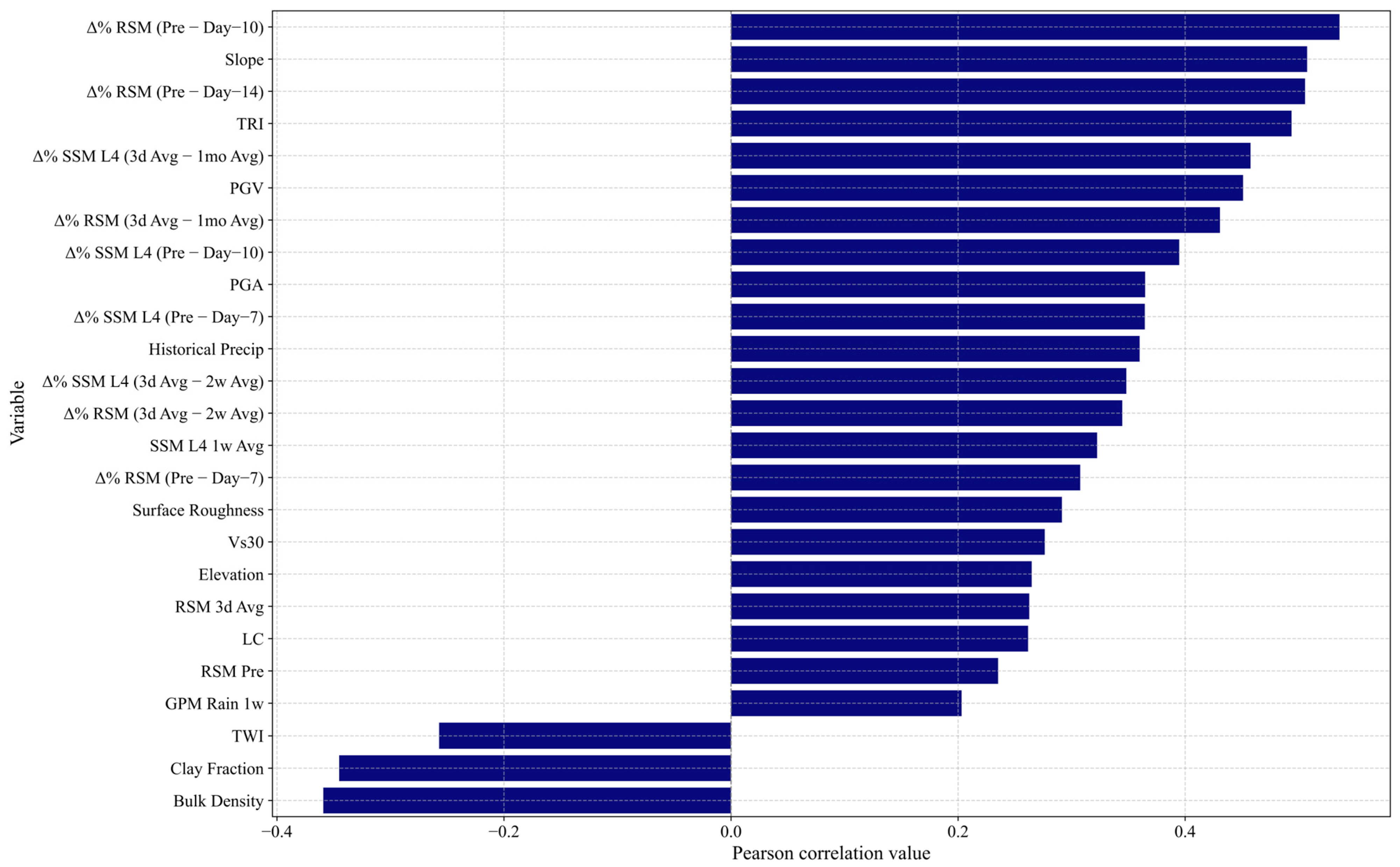
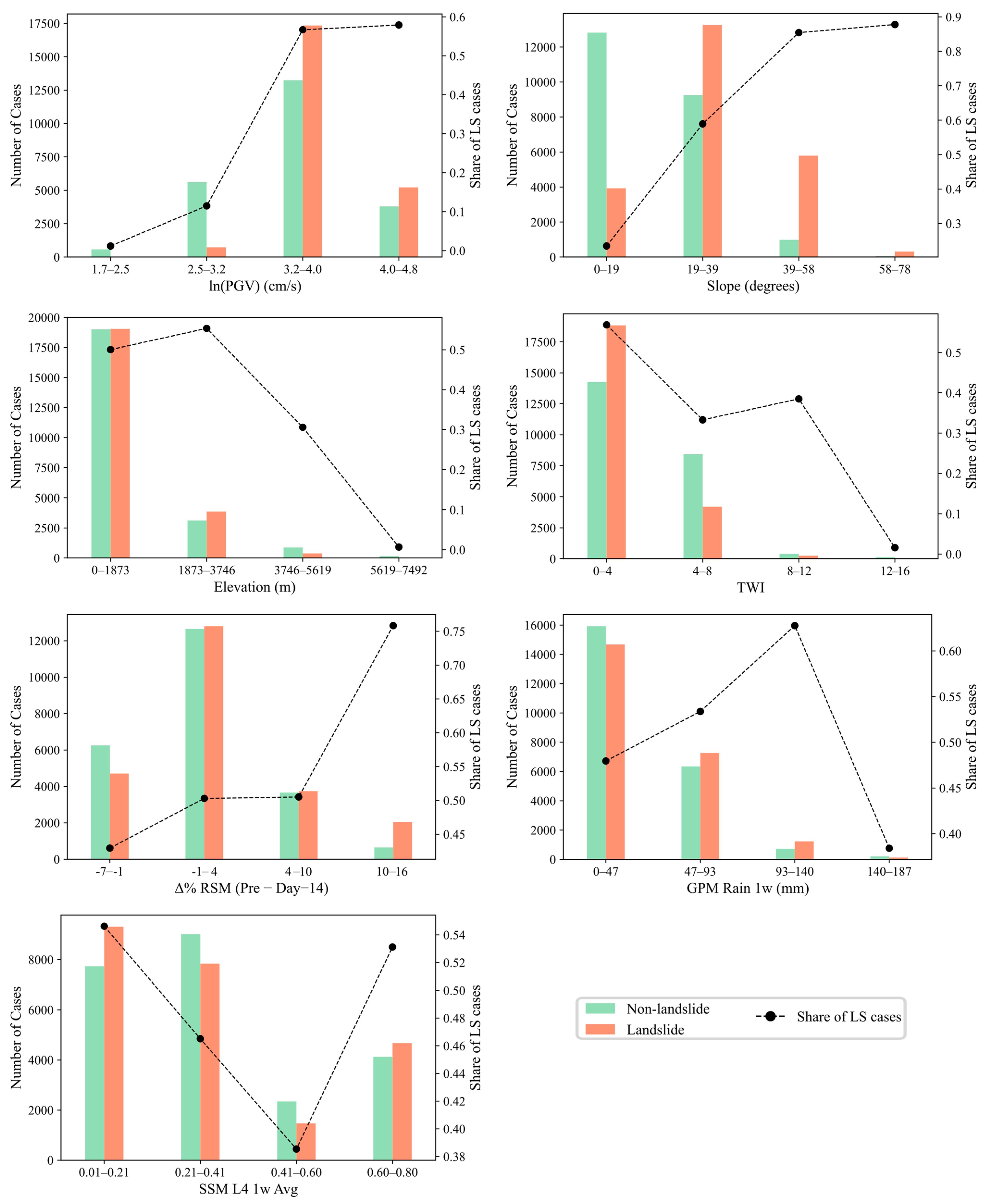
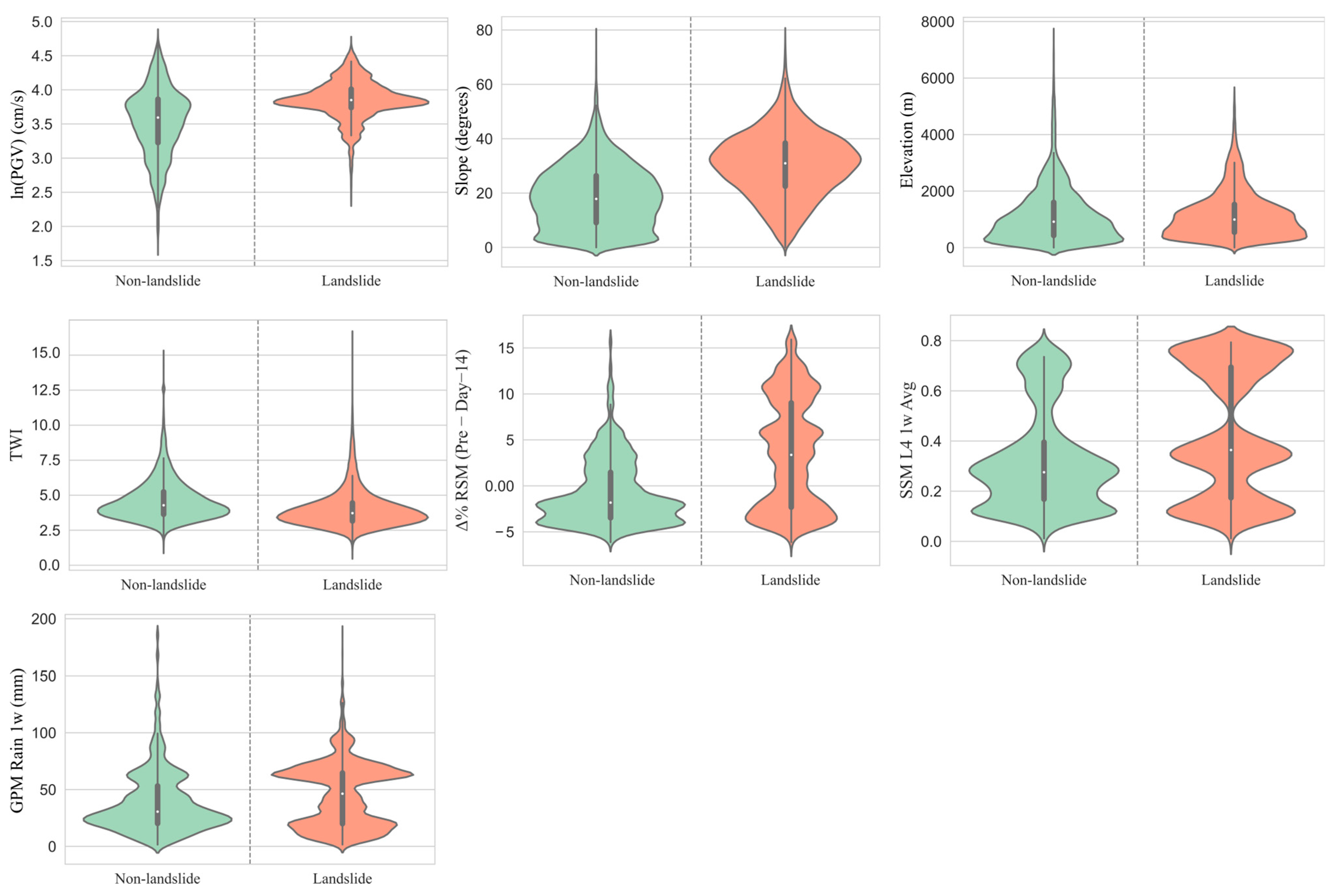
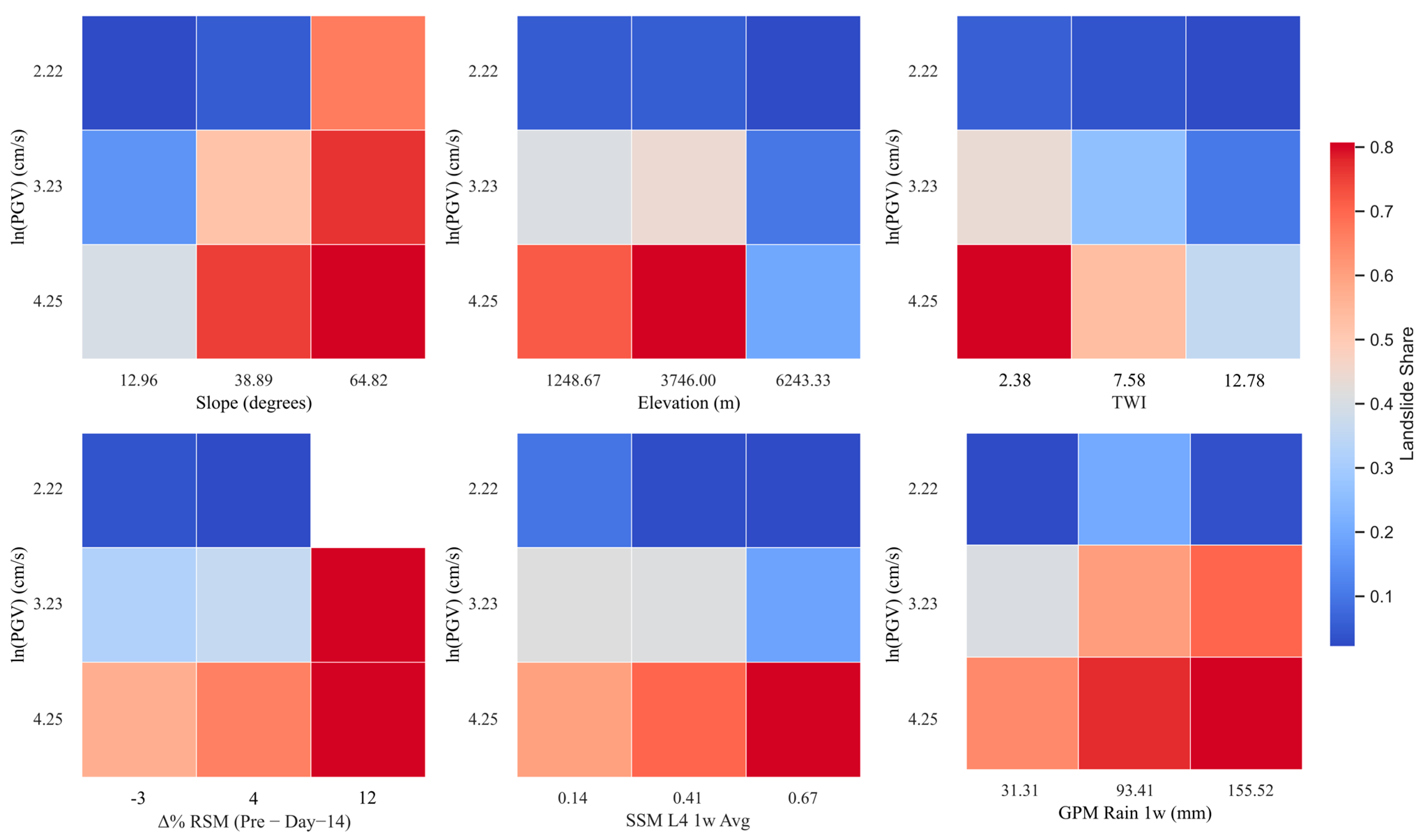
3.1. Data Exploration: Relationships Between Variables and Landslide Occurrence
3.2. Landslide Model
4. Discussion
5. Conclusions
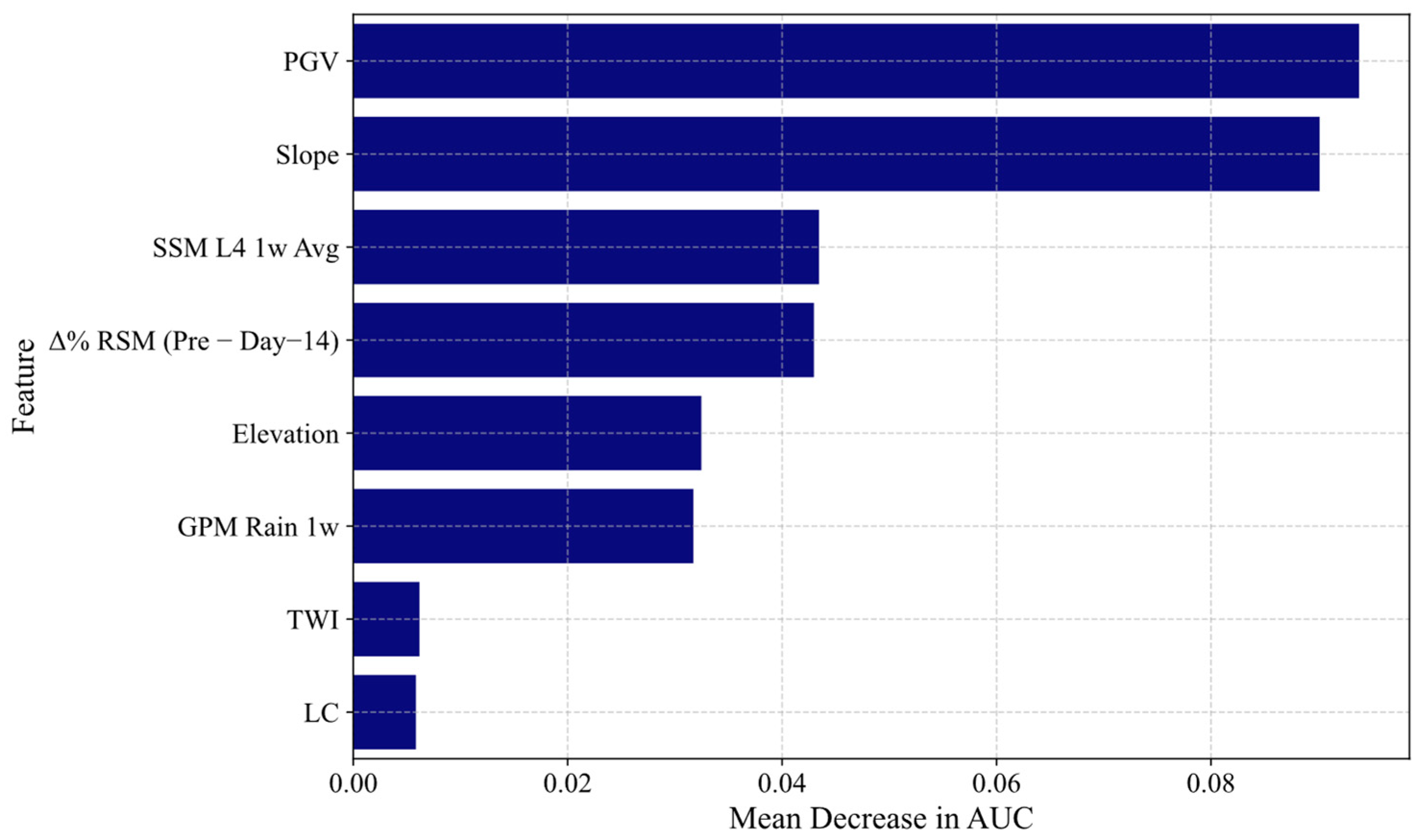
- Soil moisture improves model performance: Incorporating SMAP-derived surface and root-zone soil moisture indicators enhanced landslide prediction. Short-term indicators such as SSM L4 1w Avg and Δ% RSM (Pre − Day–14) ranked among the top predictors, reflecting the importance of hydrologic preconditioning in co-seismic slope failures.
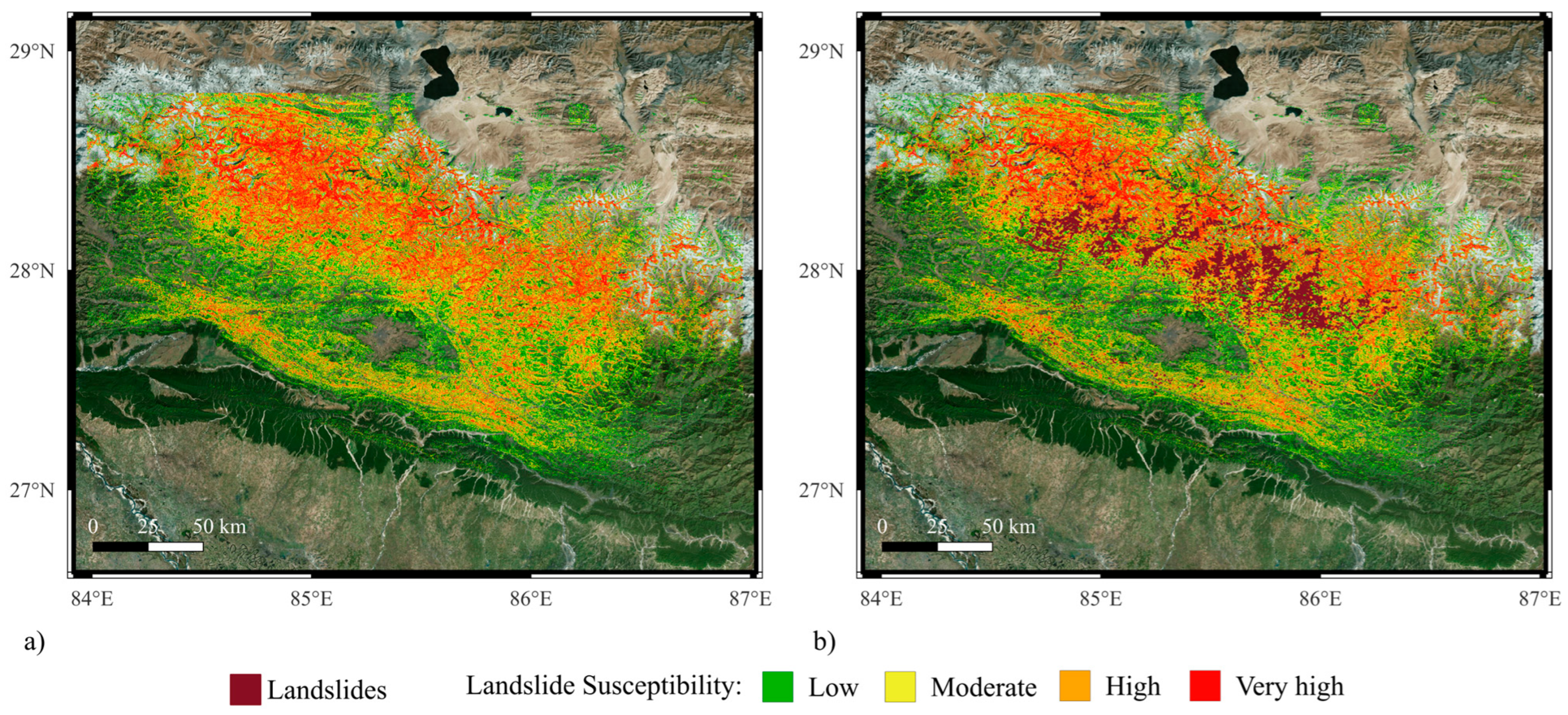
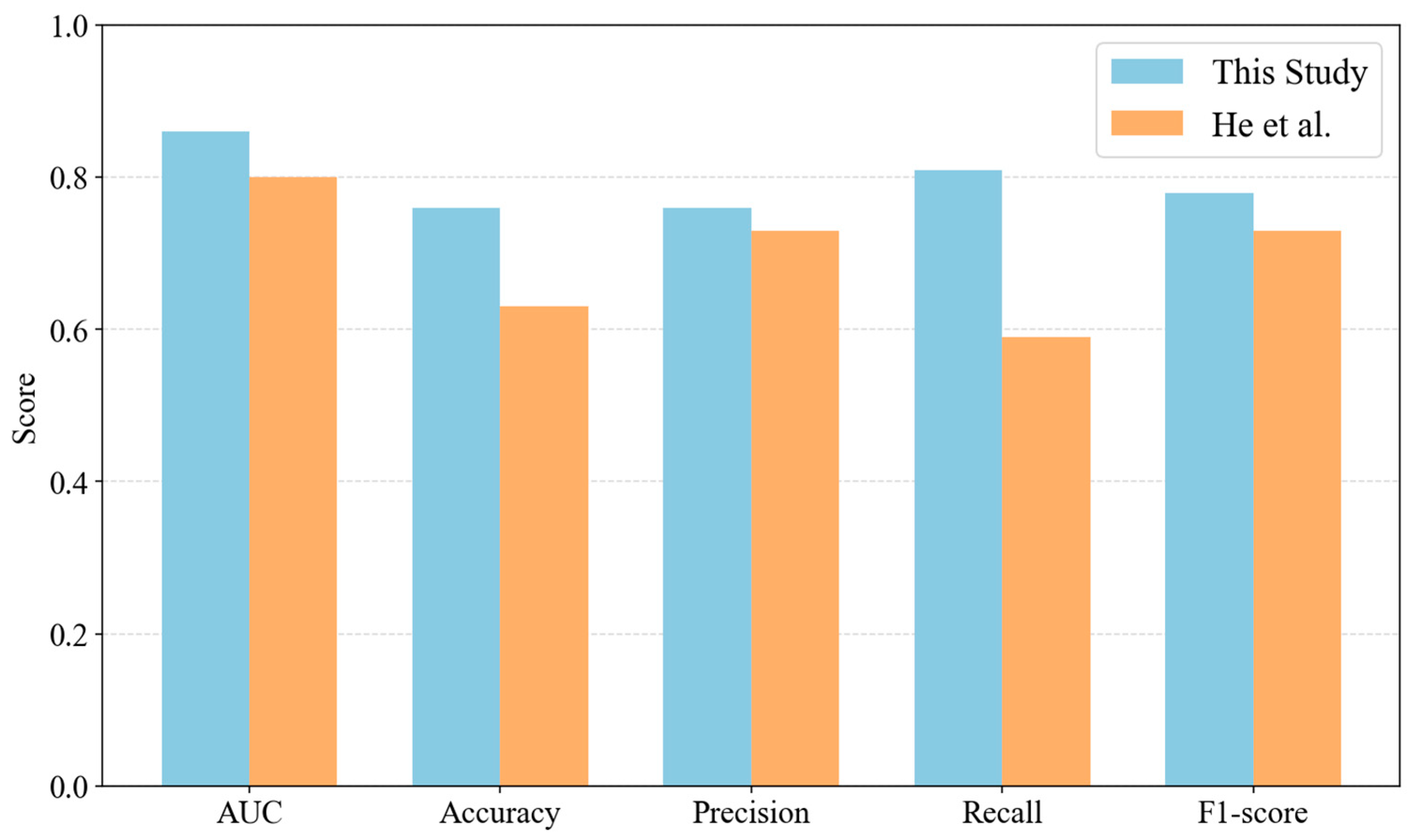
- High predictive accuracy achieved: The leave-one-earthquake-out cross-validation yielded strong performance (average AUC = 0.86, F1-score = 0.78, and accuracy = 0.83), consistently outperforming the United States Geological Survey (USGS) landslide model and another well-established global Random Forest model that did not consider soil moisture.
- Dynamic variables outperform static proxies: The use of time-varying satellite-based soil moisture and rainfall (e.g., GPM) provided better insights than static proxies like TWI. This supports the transition from static to dynamic modeling in future hazard frameworks.
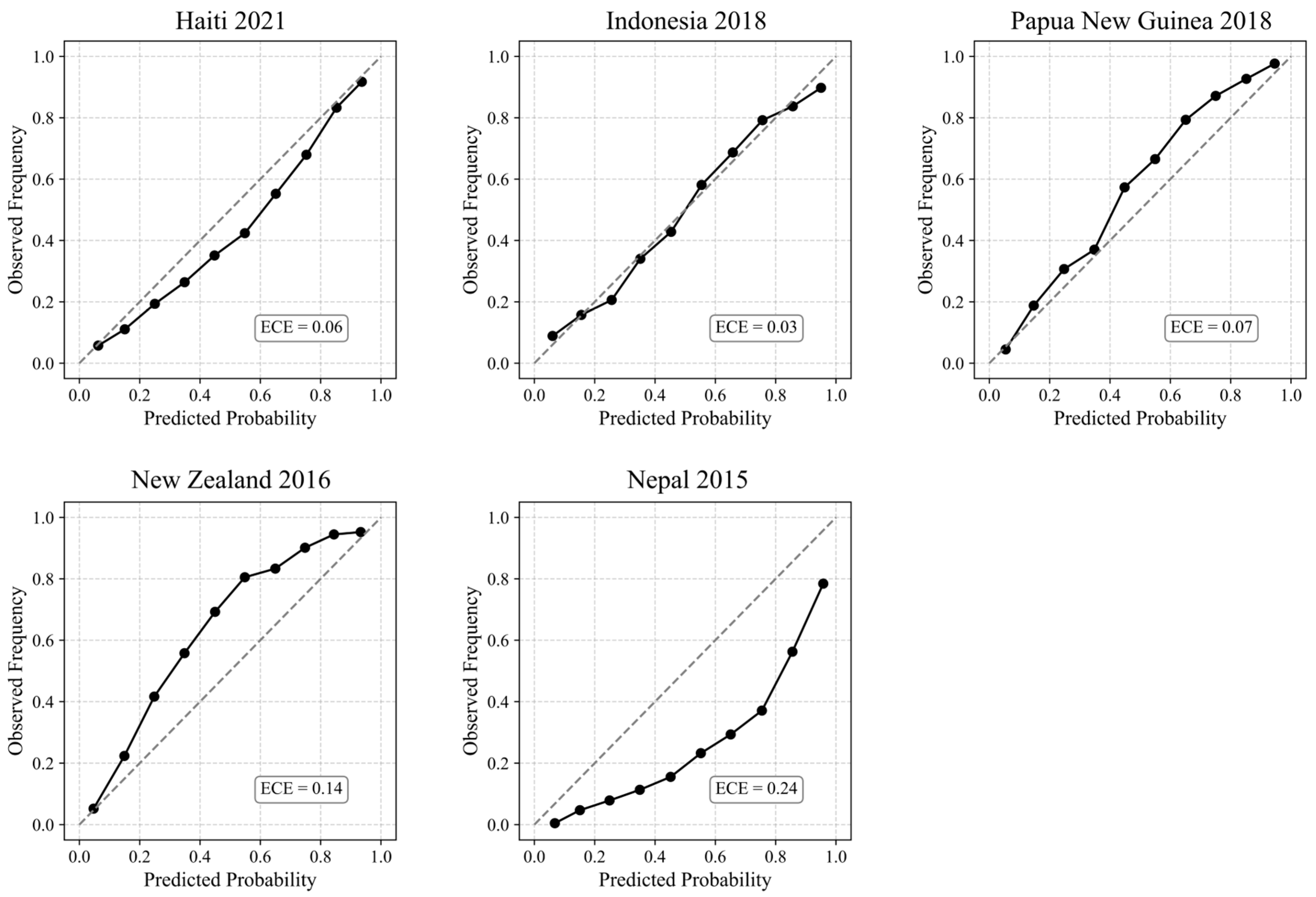
- Transferability demonstrated: The model showed generalizability across five diverse earthquake events in different climatic and geological settings, indicating its potential for near-real-time application in global earthquake impacts assessments.
Author Contributions
Funding
Data Availability Statement
Conflicts of Interest
References
- Froude, M.J.; Petley, D.N. Global Fatal Landslide Occurrence from 2004 to 2016. Nat. Hazards Earth Syst. Sci. 2018, 18, 2161–2181. [Google Scholar] [CrossRef]
- Keefer, D.K. Investigating Landslides Caused by Earthquakes—A Historical Review. Surv. Geophys. 2002, 23, 473–510. [Google Scholar] [CrossRef]
- Santangelo, N.; Forte, G.; Falco, M.; Chirico, G.B.; Santo, A. New Insights on Rainfall Triggering Flow-like Landslides and Flash Floods in Campania (Southern Italy). Landslides 2021, 18, 2923–2933. [Google Scholar] [CrossRef]
- Liu, P.; Wei, Y.; Wang, Q.; Chen, Y.; Xie, J. Research on Post-Earthquake Landslide Extraction Algorithm Based on Improved U-Net Model. Remote Sens. 2020, 12, 894. [Google Scholar] [CrossRef]
- Kalantar, B.; Ueda, N.; Saeidi, V.; Ahmadi, K.; Halin, A.A.; Shabani, F. Landslide Susceptibility Mapping: Machine and Ensemble Learning Based on Remote Sensing Big Data. Remote Sens. 2020, 12, 1737. [Google Scholar] [CrossRef]
- Bird, J.F.; Bommer, J.J. Earthquake Losses Due to Ground Failure. Eng. Geol. 2004, 75, 147–179. [Google Scholar] [CrossRef]
- Fan, X.; Scaringi, G.; Korup, O.; West, A.J.; Westen, C.J.; Tanyas, H.; Huang, R. Earthquake-induced Chains of Geologic Hazards: Patterns, Mechanisms, and Impacts. Rev. Geophys. 2019, 57, 421–503. [Google Scholar] [CrossRef]
- Allstadt, K.E.; Thompson, E.M.; Hearne, M.; Jessee, M.N.; Zhu, J.; Wald, D.J.; Tanyas, H. Integrating Landslide and Liquefaction Hazard and Loss Estimates with Existing USGS Real-time Earthquake Information Products. In Proceedings of the 16th World Conference on Earthquake Engineering, Santiago, Chile, 9–13 January 2017. [Google Scholar]
- Daniell, J.E.; Schaefer, A.M.; Wenzel, F. Losses Associated with Secondary Effects in Earthquakes. Front. Built Environ. 2017, 3, 30. [Google Scholar] [CrossRef]
- Marano, K.D.; Wald, D.J.; Allen, T.I. Global Earthquake Casualties Due to Secondary Effects: A Quantitative Analysis for Improving Rapid Loss Analyses. Nat. Hazards 2010, 52, 319–328. [Google Scholar] [CrossRef]
- Gautam, D. Unearthed Lessons of 25 April 2015 Gorkha Earthquake (MW 7.8): Geotechnical Earthquake Engineering Perspectives. Geomat. Nat. Hazards Risk 2017, 8, 1358–1382. [Google Scholar] [CrossRef]
- Xu, C.; Xu, X.; Yao, X.; Dai, F. Three (Nearly) Complete Inventories of Landslides Triggered by the May 12, 2008 Wenchuan Mw 7.9 Earthquake of China and Their Spatial Distribution Statistical Analysis. Landslides 2014, 11, 441–461. [Google Scholar] [CrossRef]
- Dai, F.C.; Xu, C.; Yao, X.; Xu, L.; Tu, X.B.; Gong, Q.M. Spatial Distribution of Landslides Triggered by the 2008 Ms 8.0 Wenchuan Earthquake, China. J. Asian Earth Sci. 2011, 40, 883–895. [Google Scholar] [CrossRef]
- Roback, K.; Clark, M.K.; West, A.J.; Zekkos, D.; Li, G.; Gallen, S.F.; Godt, J.W. The Size, Distribution, and Mobility of Landslides Caused by the 2015 Mw 7.8 Gorkha Earthquake, Nepal. Geomorphology 2018, 301, 121–138. [Google Scholar] [CrossRef]
- Hashash, Y.; Tiwari, B.; Moss, R.E.; Asimaki, D.; Clahan, K.B.; Kieffer, D.S.; Adhikari, B. Geotechnical Field Reconnaissance: Gorkha (Nepal) Earthquake of April 25 2015. Available online: https://www.geerassociation.org/components/com_geer_reports/geerfiles/Nepal_GEER_Report_V1_15.pdf (accessed on 10 July 2025).
- Kargel, J.S.; Leonard, G.J.; Shugar, D.H.; Haritashya, U.K.; Bevington, A.; Fielding, E.J.; Young, N. Geomorphic and Geologic Controls of Geohazards Induced by Nepal’s 2015 Gorkha Earthquake. Science 2016, 351, 8353. [Google Scholar] [CrossRef]
- Zhao, B. Landslides Triggered by the 2018 Mw 7.5 Palu Supershear Earthquake in Indonesia. Eng. Geol. 2021, 294, 106406. [Google Scholar] [CrossRef]
- Mason, H.B.; Gallant, A.P.; Hutabarat, D.; Montgomery, J.; Reed, A.N.; Wartman, J.; Hanifa, R. Geotechnical Reconnaissance: The 28 September 2018 M7.5 Palu-donggala, Indonesia Earthquake. 2021. Available online: https://www.geerassociation.org/?view=geerreports&id=88&layout=default (accessed on 10 July 2025).
- Natawidjaja, D.H.; Daryono, M.R.; Prasetya, G.; Liu, P.L.; Hananto, N.D.; Kongko, W.; Tawil, S. The 2018 MW 7.5 Palu ‘Supershear’Earthquake Ruptures Geological Fault’s Multisegment Separated by Large Bends: Results from Integrating Field Measurements, LiDAR, Swath Bathymetry and Seismic-Reflection Data. Geophys. J. Int. 2021, 224, 985–1002. [Google Scholar]
- Tang, C.; Westen, C.J.V.; Tanyaş, H.; Jetten, V.G. Analyzing Post-Earthquake Landslide Activity Using Multi-Temporal Landslide Inventories near the Epicentral Area of the 2008 Wenchuan Earthquake. Nat. Hazards Earth Syst. Sci. 2016, 16, 2641–2655. [Google Scholar] [CrossRef]
- Jibson, R.W.; Harp, E.L.; Michael, J.A. A method for producing digital probabilistic seismic landslide hazard maps. Eng. Geol. 2000, 58, 271–289. [Google Scholar] [CrossRef]
- Yunus, A.P.; Fan, X.; Tang, X.; Jie, D.; Xu, Q.; Huang, R. Decadal Vegetation Succession from MODIS Reveals the Spatio-Temporal Evolution of Post-Seismic Landsliding after the 2008 Wenchuan Earthquake. Remote Sens. Environ. 2020, 236, 111476. [Google Scholar] [CrossRef]
- Hovius, N.; Meunier, P.; Lin, C.W.; Chen, H.; Chen, Y.G.; Dadson, S.; Lines, M. Prolonged Seismically Induced Erosion and the Mass Balance of a Large Earthquake. Earth Planet. Sci. Lett. 2011, 304, 347–355. [Google Scholar] [CrossRef]
- Dadson, S.J.; Hovius, N.; Chen, H.; Dade, W.B.; Lin, J.C.; Hsu, M.L.; Stark, C.P. Earthquake-Triggered Increase in Sediment Delivery from an Active Mountain Belt. Geology 2004, 32, 733–736. [Google Scholar] [CrossRef]
- Wasowski, J.; Keefer, D.K.; Lee, C.T. Toward the next Generation of Research on Earthquake-Induced Landslides: Current Issues and Future Challenges. Eng. Geol. 2011, 122, 1–8. [Google Scholar] [CrossRef]
- Robinson, T.R.; Rosser, N.J.; Davies, T.R.; Wilson, T.M.; Orchiston, C. Near-real-time Modeling of Landslide Impacts to Inform Rapid Response: An Example from the 2016 Kaikōura, New Zealand, Earthquake. Bull. Seismol. Soc. Am. 2018, 108, 1665–1682. [Google Scholar] [CrossRef]
- Nowicki Jessee, M.A.; Hamburger, M.W.; Allstadt, K.; Wald, D.J.; Robeson, S.M.; Tanyas, H.; Thompson, E.M. A Global Empirical Model for Near-real-time Assessment of Seismically Induced Landslides. J. Geophys. Res. Earth Surf. 2018, 123, 1835–1859. [Google Scholar] [CrossRef]
- Shao, X.; Xu, C. Earthquake-Induced Landslides Susceptibility Assessment: A Review of the State-of-the-Art. Nat. Hazards Res. 2022, 2, 172–182. [Google Scholar] [CrossRef]
- Wang, X.; Wang, X.; Zhang, X.; Wang, L.; Guo, H.; Li, D. Near Real-Time Spatial Prediction of Earthquake-Induced Landslides: A Novel Interpretable Self-Supervised Learning Method. Int. J. Digit. Earth 2023, 16, 1885–1906. [Google Scholar] [CrossRef]
- Cheng, Q.; Tian, Y.; Lu, X.; Huang, Y.; Ye, L. Near-Real-Time Prompt Assessment for Regional Earthquake-Induced Landslides Using Recorded Ground Motions. Comput. Geosci. 2021, 149, 104709. [Google Scholar] [CrossRef]
- Alvioli, M.; Poggi, V.; Peresan, A.; Scaini, C.; Tamaro, A.; Guzzetti, F. A Scenario-Based Approach for Immediate Post-Earthquake Rockfall Impact Assessment. Landslides 2024, 21, 1–16. [Google Scholar] [CrossRef]
- Reichenbach, P.; Rossi, M.; Malamud, B.D.; Mihir, M.; Guzzetti, F. A Review of Statistically-Based Landslide Susceptibility Models. Earth-Sci. Rev. 2018, 180, 60–91. [Google Scholar] [CrossRef]
- Jibson, R.W. Methods for Assessing the Stability of Slopes during Earthquakes—A Retrospective. Eng. Geol. 2011, 122, 43–50. [Google Scholar] [CrossRef]
- Zhang, A.; Wang, X.; Pedrycz, W.; Yang, Q.; Wang, X.; Guo, H. Near Real-Time Spatial Prediction of Earthquake-Triggered Landslides Based on Global Inventories from 2008 to 2022. Soil Dyn. Earthq. Eng. 2024, 185, 108890. [Google Scholar] [CrossRef]
- Ji, J.; Zhang, W.; Zhang, F.; Gao, Y.; Lü, Q. Reliability Analysis on Permanent Displacement of Earth Slopes Using the Simplified Bishop Method. Comput. Geotech. 2020, 117, 103286. [Google Scholar] [CrossRef]
- Valagussa, A.; Frattini, P.; Crosta, G.B. Earthquake-induced rockfall hazard zoning. Eng. Geol. 2014, 182, 213–225. [Google Scholar] [CrossRef]
- Bray, J.D.; Travasarou, T. Simplified Procedure for Estimating Earthquake-Induced Deviatoric Slope Displacements. J. Geotech. Geoenviron. Eng. 2007, 133, 381–392. [Google Scholar] [CrossRef]
- Gallen, S.F.; Clark, M.K.; Godt, J.W.; Roback, K.; Niemi, N.A. Application and Evaluation of a Rapid Response Earthquake-Triggered Landslide Model to the 25 April 2015 Mw 7.8 Gorkha Earthquake, Nepal. Tectonophysics 2017, 714, 173–187. [Google Scholar] [CrossRef]
- Dreyfus, D.; Rathje, E.M.; Jibson, R.W. The Influence of Different Simplified Sliding-Block Models and Input Parameters on Regional Predictions of Seismic Landslides Triggered by the Northridge Earthquake. Eng. Geol. 2013, 163, 41–54. [Google Scholar] [CrossRef]
- Godt, J.; Sener, B.; Verdin, K.L.; Wald, D.J.; Earle, P.S.; Harp, E.L.; Jibson, R. Rapid Assessment of Earthquake-Induced Landsliding. In Proceedings of the First World Landslide Forum, Tokyo, Japan, 18–21 November 2008; United Nations University: Tokyo, Japan; Volume 4, pp. 219–222. [Google Scholar]
- Huang, D.; Wang, G.; Du, C.; Jin, F.; Feng, K.; Chen, Z. An Integrated SEM-Newmark Model for Physics-Based Regional Coseismic Landslide Assessment. Soil Dyn. Earthq. Eng. 2020, 132, 106066. [Google Scholar] [CrossRef]
- Lima, P.; Steger, S.; Glade, T.; Murillo-García, F.G. Literature Review and Bibliometric Analysis on Data-Driven Assessment of Landslide Susceptibility. J. Mt. Sci. 2022, 19, 1670–1698. [Google Scholar] [CrossRef]
- Anbalagan, R. Landslide Hazard Evaluation and Zonation Mapping in Mountainous Terrain. Eng. Geol. 1992, 32, 269–277. [Google Scholar] [CrossRef]
- Pandey, A.; Dabral, P.P.; Chowdary, V.M.; Yadav, N.K. Landslide hazard zonation using remote sensing and GIS: A case study of Dikrong river basin, Arunachal Pradesh, India. Environ. Geol. 2008, 54, 1517–1529. [Google Scholar] [CrossRef]
- Kouli, M.; Loupasakis, C.; Soupios, P.; Vallianatos, F. Landslide hazard zonation in high risk areas of Rethymno Prefecture, Crete Island, Greece. Nat. Hazards 2010, 52, 599–621. [Google Scholar] [CrossRef]
- Guzzetti, F.; Carrara, A.; Cardinali, M.; Reichenbach, P. Landslide Hazard Evaluation: A Review of Current Techniques and Their Application in a Multi-Scale Study, Central Italy. Geomorphology 1999, 31, 181–216. [Google Scholar] [CrossRef]
- Nadim, F.; Kjekstad, O.; Peduzzi, P.; Herold, C.; Jaedicke, C. Global landslide and avalanche hotspots. Landslides 2006, 3, 159–173. [Google Scholar] [CrossRef]
- Shano, L.; Raghuvanshi, T.K.; Meten, M. Landslide Susceptibility Evaluation and Hazard Zonation Techniques—A Review. Geoenviron. Disasters 2020, 7, 18. [Google Scholar] [CrossRef]
- Carrara, A.; Cardinali, M.; Guzzetti, F.; Reichenbach, P. GIS technology in mapping landslide hazard. In Geographical Information Systems in Assessing Natural Hazards; Springer: Dordrecht, The Netherlands, 1995; pp. 135–175. [Google Scholar]
- Lee, C.T.; Huang, C.C.; Lee, J.F.; Pan, K.L.; Lin, M.L.; Dong, J.J. Statistical Approach to Earthquake-Induced Landslide Susceptibility. Eng. Geol. 2008, 100, 43–58. [Google Scholar] [CrossRef]
- Farahani, A.; Ghayoomi, M. Soil moisture-based global liquefaction model (SMGLM) using soil moisture active passive (SMAP) satellite data. Soil Dyn. Earthq. Eng. 2024, 177, 108350. [Google Scholar] [CrossRef]
- Nowicki, M.A.; Wald, D.J.; Hamburger, M.W.; Hearne, M.; Thompson, E.M. Development of a Globally Applicable Model for near Real-Time Prediction of Seismically Induced Landslides. Eng. Geol. 2014, 173, 54–65. [Google Scholar] [CrossRef]
- Farahani, A.; Ghayoomi, M. Updates to a Soil Moisture-Based Global Liquefaction Model. Jpn. Geotech. Soc. Spec. Publ. 2024, 10, 860–865. [Google Scholar] [CrossRef]
- Umar, Z.; Pradhan, B.; Ahmad, A.; Jebur, M.N.; Tehrany, M.S. Earthquake Induced Landslide Susceptibility Mapping Using an Integrated Ensemble Frequency Ratio and Logistic Regression Models in West Sumatera Province, Indonesia. Catena 2014, 118, 124–135. [Google Scholar] [CrossRef]
- Batar, A.K.; Watanabe, T. Landslide Susceptibility Mapping and Assessment Using Geospatial Platforms and Weights of Evidence (WoE) Method in the Indian Himalayan Region: Recent Developments, Gaps, and Future Directions. ISPRS Int. J. Geo-Inf. 2021, 10, 114. [Google Scholar] [CrossRef]
- Kritikos, T.; Robinson, T.R.; Davies, T.R. Regional Coseismic Landslide Hazard Assessment without Historical Landslide Inventories: A New Approach. J. Geophys. Res. Earth Surf. 2015, 120, 711–729. [Google Scholar] [CrossRef]
- Parker, R.N.; Rosser, N.J.; Hales, T.C. Spatial Prediction of Earthquake-Induced Landslide Probability. Nat. Hazards Earth Syst. Sci. Discuss. 2017, 2017, 1–29. [Google Scholar]
- Farahani, A.; Moradikhaneghahi, M.; Ghayoomi, M.; Jacobs, J.M. Application of soil moisture active passive (SMAP) satellite data in seismic response assessment. Remote Sens. 2022, 14, 4375. [Google Scholar] [CrossRef]
- Ghayoomi, M.; Farahani, A. Soil Moisture From Space. GeoStrata Mag. Arch. 2025, 29, 30–38. [Google Scholar] [CrossRef]
- Farahani, A.; Ghayoomi, M. Assessing Correlations between SAR-Based Damage Proxy Maps and Geospatial Variables for Enhanced Earthquake Damage Analysis. In Proceedings of the Geotechnical Frontiers 2025, Louisville, Kentucky, 2–5 March 2025; pp. 328–336. Available online: https://ascelibrary.org/doi/abs/10.1061/9780784485989.033 (accessed on 10 July 2025).
- Sun, D.; Chen, D.; Zhang, J.; Mi, C.; Gu, Q.; Wen, H. Landslide Susceptibility Mapping Based on Interpretable Machine Learning from the Perspective of Geomorphological Differentiation. Land 2023, 12, 1018. [Google Scholar] [CrossRef]
- Ma, S.; Shao, X.; Xu, C. Estimating the Quality of the Most Popular Machine Learning Algorithms for Landslide Susceptibility Mapping in 2018 Mw 7.5 Palu Earthquake. Remote Sens. 2023, 15, 4733. [Google Scholar] [CrossRef]
- Xiao, S.; Xiao, T.; Jiang, R.; Wang, H.; Ju, L.; Zhang, L. Two-Phase Strategy for Rapid and Unbiased Assessment of Earthquake-Induced Landslides. Eng. Geol. 2024, 336, 107562. [Google Scholar] [CrossRef]
- Farahani, A.; Ghayoomi, M.; Jacobs, J.M. The Use of SMAP to Investigate the Application of Remotely Sensed Soil Moisture Data in Earthquake Impacts Assessment. In Proceedings of the AGU Fall Meeting Abstracts, San Francisco, CA, USA, 11–15 December 2023; Volume 2023, p. H13M-1639. [Google Scholar]
- Das, R.; Tien, P.V.; Wegmann, K.W.; Chakraborty, M. Machine Learning-Based Assessment of Regional-Scale Variation of Landslide Susceptibility in Central Vietnam. PLoS ONE 2024, 19, e0308494. [Google Scholar] [CrossRef] [PubMed]
- Regmi, A.D.; Dhital, M.R.; Zhang, J.Q.; Su, L.J.; Chen, X.Q. Landslide Susceptibility Assessment of the Region Affected by the 25 April 2015 Gorkha Earthquake of Nepal. J. Mt. Sci. 2016, 13, 1941–1957. [Google Scholar] [CrossRef]
- Pyakurel, A.; Dahal, B.K.; Gautam, D. Does Machine Learning Adequately Predict Earthquake Induced Landslides? Soil Dyn. Earthq. Eng. 2023, 171, 107994. [Google Scholar] [CrossRef]
- Zhang, W.; Li, H.; Han, L.; Chen, L.; Wang, L. Slope Stability Prediction Using Ensemble Learning Techniques: A Case Study in Yunyang County, Chongqing, China. J. Rock Mech. Geotech. Eng. 2022, 14, 1089–1099. [Google Scholar] [CrossRef]
- Dou, J.; Yunus, A.P.; Bui, D.T.; Merghadi, A.; Sahana, M.; Zhu, Z.; Pham, B.T. Improved Landslide Assessment Using Support Vector Machine with Bagging, Boosting, and Stacking Ensemble Machine Learning Framework in a Mountainous Watershed, Japan. Landslides 2020, 17, 641–658. [Google Scholar] [CrossRef]
- Chang, Z.; Du, Z.; Zhang, F.; Huang, F.; Chen, J.; Li, W.; Guo, Z. Landslide Susceptibility Prediction Based on Remote Sensing Images and GIS: Comparisons of Supervised and Unsupervised Machine Learning Models. Remote Sens. 2020, 12, 502. [Google Scholar] [CrossRef]
- Karakas, G.; Unal, E.O.; Cetinkaya, S.; Ozcan, N.T.; Karakas, V.E.; Can, R.; Kocaman, S. Analysis of Landslide Susceptibility Prediction Accuracy with an Event-Based Inventory: The 6 February 2023 Turkiye Earthquakes. Soil Dyn. Earthq. Eng. 2024, 178, 108491. [Google Scholar] [CrossRef]
- Lary, D.J.; Alavi, A.H.; Gandomi, A.H.; Walker, A.L. Machine Learning in Geosciences and Remote Sensing. Geosci. Front. 2016, 7, 3–10. [Google Scholar] [CrossRef]
- Merghadi, A.; Yunus, A.P.; Dou, J.; Whiteley, J.; ThaiPham, B.; Bui, D.T.; Abderrahmane, B. Machine Learning Methods for Landslide Susceptibility Studies: A Comparative Overview of Algorithm Performance. Earth-Sci. Rev. 2020, 207, 103225. [Google Scholar] [CrossRef]
- Dahal, A.; Lombardo, L. Explainable Artificial Intelligence in Geoscience: A Glimpse into the Future of Landslide Susceptibility Modeling. Comput. Geosci. 2023, 176, 105364. [Google Scholar] [CrossRef]
- Hong, H.; Shahabi, H.; Shirzadi, A.; Chen, W.; Chapi, K.; Ahmad, B.B.; Tien Bui, D. Landslide Susceptibility Assessment at the Wuning Area, China: A Comparison between Multi-Criteria Decision Making, Bivariate Statistical and Machine Learning Methods. Nat. Hazards 2019, 96, 173–212. [Google Scholar] [CrossRef]
- Meena, S.R.; Ghorbanzadeh, O.; Blaschke, T. A Comparative Study of Statistics-Based Landslide Susceptibility Models: A Case Study of the Region Affected by the Gorkha Earthquake in Nepal. ISPRS Int. J. Geo-Inf. 2019, 8, 94. [Google Scholar] [CrossRef]
- Zhao, Z.; Liu, Z.Y.; Xu, C. Slope Unit-Based Landslide Susceptibility Mapping Using Certainty Factor, Support Vector Machine, Random Forest, CF-SVM and CF-RF Models. Front. Earth Sci. 2021, 9, 589630. [Google Scholar] [CrossRef]
- Zhao, X.; Chen, W. GIS-Based Evaluation of Landslide Susceptibility Models Using Certainty Factors and Functional Trees-Based Ensemble Techniques. Appl. Sci. 2019, 10, 16. [Google Scholar] [CrossRef]
- Arabameri, A.; Pradhan, B.; Rezaei, K.; Lee, C.W. Assessment of Landslide Susceptibility Using Statistical-and Artificial Intelligence-Based FR–RF Integrated Model and Multiresolution DEMs. Remote Sens. 2019, 11, 999. [Google Scholar] [CrossRef]
- Sepúlveda, S.A. Earthquake-Induced Landslide Susceptibility and Hazard Assessment Approaches. In Coseismic Landslides: Phenomena, Long-Term Effects and Mitigation; Springer Nature: Singapore, 2022; pp. 543–571. [Google Scholar]
- Caccavale, M.; Matano, F.; Sacchi, M. An Integrated Approach to Earthquake-Induced Landslide Hazard Zoning Based on Probabilistic Seismic Scenario for Phlegrean Islands (Ischia, Procida and Vivara), Italy. Geomorphology 2017, 295, 235–259. [Google Scholar] [CrossRef]
- Gupta, K.; Satyam, N. An Integrated Approach to Co-Seismic Landslide Hazard Assessment by Probabilistic Modeling of Parametrical Uncertainties in Modified Newmark’s Model. Indian Geotech. J. 2024, 1–11. [Google Scholar] [CrossRef]
- Oleng, M.; Ozdemir, Z.; Pilakoutas, K. Co-Seismic and Rainfall-Triggered Landslide Hazard Susceptibility Assessment for Uganda Derived Using Fuzzy Logic and Geospatial Modelling Techniques. Nat. Hazards 2024, 120, 14049–14082. [Google Scholar] [CrossRef]
- Wang, Y.; Song, C.; Lin, Q.; Li, J. Occurrence Probability Assessment of Earthquake-Triggered Landslides with Newmark Displacement Values and Logistic Regression: The Wenchuan Earthquake, China. Geomorphology 2016, 258, 108–119. [Google Scholar] [CrossRef]
- Cheng, Y.; Wang, J.; He, Y. Prediction Models of Newmark Sliding Displacement of Slopes Using Deep Neural Network and Mixed-Effect Regression. Comput. Geotech. 2023, 156, 105264. [Google Scholar] [CrossRef]
- Tanyas, H.; Rossi, M.; Alvioli, M.; Westen, C.J.; Marchesini, I. A Global Slope Unit-Based Method for the near Real-Time Prediction of Earthquake-Induced Landslides. Geomorphology 2019, 327, 126–146. [Google Scholar] [CrossRef]
- Farahani, A.; Ghayoomi, M.; Jacobs, J.M. Soil Moisture Active Passive (SMAP) Data for Ground Monitoring during Earthquakes. In Proceedings of the Geo-Congress 2023, Los Angeles, CA, USA, 26–29 March 2023; pp. 409–418. [Google Scholar]
- Farahani, A.; Ghayoomi, M.; Jacobs, J.M. Soil Moisture Active Passive (SMAP) Satellite Data and Unsaturated Soil Response. In Proceedings of the 8th International Conference on Unsaturated Soils (UNSAT 2023), Milos, Greece, 2–5 May 2023; EDP Sciences: Les Ulis, France, 2023; Volume 382, p. 03006. [Google Scholar]
- He, Q.; Wang, M.; Liu, K. Rapidly Assessing Earthquake-Induced Landslide Susceptibility on a Global Scale Using Random Forest. Geomorphology 2021, 391, 107889. [Google Scholar] [CrossRef]
- Meunier, P.; Hovius, N.; Haines, J.A. Topographic Site Effects and the Location of Earthquake Induced Landslides. Earth Planet. Sci. Lett. 2008, 275, 221–232. [Google Scholar] [CrossRef]
- Tanyaş, H.; Hill, K.; Mahoney, L.; Fadel, I.; Lombardo, L. The World’s Second-Largest, Recorded Landslide Event: Lessons Learnt from the Landslides Triggered during and after the 2018 Mw 7.5 Papua New Guinea Earthquake. Eng. Geol. 2022, 297, 106504. [Google Scholar] [CrossRef]
- Nocentini, N.; Rosi, A.; Segoni, S.; Fanti, R. Towards Landslide Space-Time Forecasting through Machine Learning: The Influence of Rainfall Parameters and Model Setting. Front. Earth Sci. 2023, 11, 1152130. [Google Scholar] [CrossRef]
- Li, B.; Liu, K.; Wang, M.; He, Q.; Jiang, Z.; Zhu, W.; Qiao, N. Global Dynamic Rainfall-Induced Landslide Susceptibility Mapping Using Machine Learning. Remote Sens. 2022, 14, 5795. [Google Scholar] [CrossRef]
- Ebrahim, K.M.; Fares, A.; Faris, N.; Zayed, T. Exploring Time Series Models for Landslide Prediction: A Literature Review. Geoenviron. Disasters 2024, 11, 25. [Google Scholar] [CrossRef]
- Felsberg, A.; Poesen, J.; Bechtold, M.; Vanmaercke, M.; De Lannoy, G.J. Estimating Global Landslide Susceptibility and Its Uncertainty through Ensemble Modeling. Nat. Hazards Earth Syst. Sci. 2022, 22, 3063–3082. [Google Scholar] [CrossRef]
- Paprocki, J.; Stark, N.; Wadman, H. A Framework for Assessing the Bearing Capacity of Sandy Coastal Soils from Remotely Sensed Moisture Contents. J. Geotech. Geoenviron. Eng. 2023, 149, 04023083. [Google Scholar] [CrossRef]
- Dashbold, B.; Bryson, L.S.; Crawford, M.M. Landslide Hazard and Susceptibility Maps Derived from Satellite and Remote Sensing Data Using Limit Equilibrium Analysis and Machine Learning Model. Nat. Hazards 2023, 116, 235–265. [Google Scholar] [CrossRef]
- Xu, Q.; Zhao, B.; Dai, K.; Dong, X.; Li, W.; Zhu, X.; Ge, D. Remote Sensing for Landslide Investigations: A Progress Report from China. Eng. Geol. 2023, 321, 107156. [Google Scholar] [CrossRef]
- Casagli, N.; Intrieri, E.; Tofani, V.; Gigli, G.; Raspini, F. Landslide Detection, Monitoring and Prediction with Remote-Sensing Techniques. Nat. Rev. Earth Environ. 2023, 4, 51–64. [Google Scholar] [CrossRef]
- Akosah, S.; Gratchev, I.; Kim, D.H.; Ohn, S.Y. Application of Artificial Intelligence and Remote Sensing for Landslide Detection and Prediction: Systematic Review. Remote Sens. 2024, 16, 2947. [Google Scholar] [CrossRef]
- Ji, S.; Yu, D.; Shen, C.; Li, W.; Xu, Q. Landslide detection from an open satellite imagery and digital elevation model dataset using attention boosted convolutional neural networks. Landslides 2020, 17, 1337–1352. [Google Scholar] [CrossRef]
- Asadi, A.; Baise, L.G.; Koch, M.; Moaveni, B.; Chatterjee, S.; Aimaiti, Y. Pixel-Based Classification Method for Earthquake-Induced Landslide Mapping Using Remotely Sensed Imagery, Geospatial Data and Temporal Change Information. Nat. Hazards 2024, 120, 5163–5200. [Google Scholar] [CrossRef]
- Massey, C.; Townsend, D.; Rathje, E.; Allstadt, K.E.; Lukovic, B.; Kaneko, Y.; Villeneuve, M. Landslides Triggered by the 14 November 2016 Mw 7.8 Kaikōura Earthquake, New Zealand. Bull. Seismol. Soc. Am. 2018, 108, 1630–1648. [Google Scholar] [CrossRef]
- Martinez, S.N.; Allstadt, K.E.; Slaughter, S.L.; Schmitt, R.G.; Collins, E.; Schaefer, L.N.; Ellison, S. Rapid Response Landslide Inventory for the 14 August 2021 M7. 2 Nippes, Haiti, Earthquake: US Geological Survey data release. Available online: https://pubs.usgs.gov/publication/ofr20211112 (accessed on 10 July 2025).
- Guo, Z.; Zeng, T.; Zhang, Y.; Yu, W.; Wang, L.; Guo, Z.; Glade, T. A Novel Hybrid Model Integrating High Resolution Remote Sensing and Stacking Ensemble Techniques for Landslide Susceptibility Mapping: Application to Event-Based Landslide Inventory. Geomorphology 2025, 486, 109886. [Google Scholar] [CrossRef]
- Francis, D.M.; Bryson, L.S. Coupled Landslide Analyses through Dynamic Susceptibility and Forecastable Hazard Analysis. Nat. Hazards 2024, 121, 2971–2999. [Google Scholar] [CrossRef]
- Zhao, B.; Dai, Q.; Zhuo, L.; Zhu, S.; Shen, Q.; Han, D. Assessing the Potential of Different Satellite Soil Moisture Products in Landslide Hazard Assessment. Remote Sens. Environ. 2021, 264, 112583. [Google Scholar] [CrossRef]
- Bordoni, M.; Vivaldi, V.; Ciabatta, L.; Brocca, L.; Meisina, C. Temporal Prediction of Shallow Landslides Exploiting Soil Saturation Degree Derived by ERA5-Land Products. Bull. Eng. Geol. Environ. 2023, 82, 308. [Google Scholar] [CrossRef]
- Felsberg, A.; Lannoy, G.J.; Girotto, M.; Poesen, J.; Reichle, R.H.; Stanley, T. Global Soil Water Estimates as Landslide Predictor: The Effectiveness of SMOS, SMAP, and GRACE Observations, Land Surface Simulations, and Data Assimilation. J. Hydrometeorol. 2021, 22, 1065–1084. [Google Scholar] [CrossRef]
- Abraham, M.T.; Satyam, N.; Rosi, A.; Pradhan, B.; Segoni, S. Usage of Antecedent Soil Moisture for Improving the Performance of Rainfall Thresholds for Landslide Early Warning. Catena 2021, 200, 105147. [Google Scholar] [CrossRef]
- Entekhabi, D.; Njoku, E.G.; O’neill, P.E.; Kellogg, K.H.; Crow, W.T.; Edelstein, W.N.; Zyl, J. The Soil Moisture Active Passive (SMAP) Mission. Proc. IEEE 2010, 98, 704–716. [Google Scholar] [CrossRef]
- Stillman, S.; Zeng, X. Evaluation of SMAP Soil Moisture Relative to Five Other Satellite Products Using the Climate Reference Network Measurements over USA. IEEE Trans. Geosci. Remote Sens. 2018, 56, 6296–6305. [Google Scholar] [CrossRef]
- Chen, Q.; Zeng, J.; Cui, C.; Li, Z.; Chen, K.S.; Bai, X.; Xu, J. Soil Moisture Retrieval from SMAP: A Validation and Error Analysis Study Using Ground-Based Observations over the Little Washita Watershed. IEEE Trans. Geosci. Remote Sens. 2017, 56, 1394–1408. [Google Scholar] [CrossRef]
- Colliander, A.; Cosh, M.H.; Misra, S.; Jackson, T.J.; Crow, W.T.; Powers, J.; Yueh, S. Comparison of High-Resolution Airborne Soil Moisture Retrievals to SMAP Soil Moisture during the SMAP Validation Experiment 2016 (SMAPVEX16). Remote Sens. Environ. 2019, 227, 137–150. [Google Scholar] [CrossRef]
- Forgotson, C.; O’Neill, P.E.; Carrera, M.L.; Bélair, S.; Das, N.N.; Mladenova, I.E.; Escobar, V.M. How Satellite Soil Moisture Data Can Help to Monitor the Impacts of Climate Change: SMAP Case Studies. IEEE J. Sel. Top. Appl. Earth Obs. Remote Sens. 2020, 13, 1590–1596. [Google Scholar] [CrossRef]
- Karthikeyan, L.; Chawla, I.; Mishra, A.K. A Review of Remote Sensing Applications in Agriculture for Food Security: Crop Growth and Yield, Irrigation, and Crop Losses. J. Hydrol. 2020, 586, 124905. [Google Scholar] [CrossRef]
- Davitt, A.; Schumann, G.; Forgotson, C.; McDonald, K.C. The Utility of SMAP Soil Moisture and Freeze-Thaw Datasets as Precursors to Spring-Melt Flood Conditions: A Case Study in the Red River of the North Basin. IEEE J. Sel. Top. Appl. Earth Obs. Remote Sens. 2019, 12, 2848–2861. [Google Scholar] [CrossRef]
- Rateb, A.; Hermas, E. The 2018 Long Rainy Season in Kenya: Hydrological Changes and Correlated Land Subsidence. Remote Sens. 2020, 12, 1390. [Google Scholar] [CrossRef]
- Xu, Y.; Kim, J.; George, D.L.; Lu, Z. Characterizing Seasonally Rainfall-Driven Movement of a Translational Landslide Using SAR Imagery and SMAP Soil Moisture. Remote Sens. 2019, 11, 2347. [Google Scholar] [CrossRef]
- Rizzo, R.J.; Bryson, L.S. Remote Sensing Using Satellite Derived Products to Assess Sinkhole Occurrence. In Proceedings of the Geo-Congress 2023, Los Angeles, CA, USA, 26–29 March 2023; pp. 52–61. [Google Scholar]
- Schmitt, R.G.; Tanyas, H.; Jessee, M.N.; Zhu, J.; Biegel, K.M.; Allstadt, K.E.; Jibson, R.W.; Thompson, E.M.; van Westen, C.J.; Sato, H.P. An Open Repository of Earthquake-Triggered Ground-Failure Inventories: Data Release Collection. 2017. Available online: https://www.sciencebase.gov/catalog/item/583f4114e4b04fc80e3c4a1a (accessed on 10 July 2025).
- Tanyaş, H.; Görüm, T.; Fadel, I.; Yıldırım, C.; Lombardo, L. An Open Dataset for Landslides Triggered by the 2016 Mw 7.8 Kaikōura Earthquake, New Zealand. Landslides 2022, 19, 1405–1420. [Google Scholar] [CrossRef]
- Hungr, O.; Leroueil, S.; Picarelli, L. The Varnes Classification of Landslide Types, an Update. Landslides 2014, 11, 167–194. [Google Scholar] [CrossRef]
- Causes, L. Landslide Types and Processes; US Geological Survey: Reston, VA, USA, 2001. [Google Scholar]
- Bui, D.T.; Tsangaratos, P.; Nguyen, V.-T.; Van Liem, N.; Trinh, P.T. Comparing the Prediction Performance of a Deep Learning Neural Network Model with Conventional Machine Learning Models in Landslide Susceptibility Assessment. Catena 2020, 188, 104426. [Google Scholar] [CrossRef]
- Pourghasemi, H.R.; Rahmati, O. Prediction of the Landslide Susceptibility: Which Algorithm, Which Precision? Catena 2018, 162, 177–192. [Google Scholar] [CrossRef]
- Huang, F.; Xiong, H.; Yao, C.; Catani, F.; Zhou, C.; Huang, J. Uncertainties of Landslide Susceptibility Prediction Considering Different Landslide Types. J. Rock Mech. Geotech. Eng. 2023, 15, 2954–2972. [Google Scholar] [CrossRef]
- Yang, C.; Liu, L.-L.; Huang, F.; Huang, L.; Wang, X.-M. Machine Learning-Based Landslide Susceptibility Assessment with Optimized Ratio of Landslide to Non-Landslide Samples. Gondwana Res. 2023, 123, 198–216. [Google Scholar] [CrossRef]
- Sun, Q.; Miao, C.; Duan, Q.; Ashouri, H.; Sorooshian, S.; Hsu, K.-L. A Review of Global Precipitation Data Sets: Data Sources, Estimation, and Intercomparisons. Rev. Geophys. 2018, 56, 79–107. [Google Scholar] [CrossRef]
- NASA Goddard Earth Sciences Data and Information Services Center (GES DISC). (n.d.); Giovanni: Visualization and Analysis Tool. NASA. Available online: https://Giovanni.Gsfc.Nasa.Gov/Giovanni/ (accessed on 1 July 2025).
- Wald, D.J.; Allen, T.I. Topographic Slope as a Proxy for Seismic Site Conditions and Amplification. Bull. Seismol. Soc. Am. 2007, 97, 1379–1395. [Google Scholar] [CrossRef]
- Breiman, L. Random Forests. Mach. Learn. 2001, 45, 5–32. [Google Scholar] [CrossRef]
- Genuer, R.; Poggi, J.-M.; Tuleau-Malot, C.; Villa-Vialaneix, N. Random Forests for Big Data. Big Data Res. 2017, 9, 28–46. [Google Scholar] [CrossRef]
- Sun, D.; Wen, H.; Wang, D.; Xu, J. A Random Forest Model of Landslide Susceptibility Mapping Based on Hyperparameter Optimization Using Bayes Algorithm. Geomorphology 2020, 362, 107201. [Google Scholar] [CrossRef]
- Gerds, T.A.; Cai, T.; Schumacher, M. The Performance of Risk Prediction Models. Biom. J. J. Math. Methods Biosci. 2008, 50, 457–479. [Google Scholar] [CrossRef] [PubMed]
- Gweon, H.; Yu, H. How Reliable Is Your Reliability Diagram? Pattern Recognit. Lett. 2019, 125, 687–693. [Google Scholar] [CrossRef]
- DeGroot, M.H.; Fienberg, S.E. The Comparison and Evaluation of Forecasters. J. R. Stat. Soc. Ser. D Stat. 1983, 32, 12–22. [Google Scholar] [CrossRef]
- Wang, F.; Zhou, L.; Zhao, J.; Liu, Y.; Chen, J.; Wen, Z.; Zheng, C.; Hong, W.; Chen, C.-H. Selection of Optimal Factor Combinations for Typhoon-Induced Landslides Susceptibility Mapping Using Machine Learning Interpretability. Geomorphology 2025, 484, 109855. [Google Scholar] [CrossRef]
- Qiu, H.; Xu, Y.; Tang, B.; Su, L.; Li, Y.; Yang, D.; Ullah, M. Interpretable Landslide Susceptibility Evaluation Based on Model Optimization. Land 2024, 13, 639. [Google Scholar] [CrossRef]
- USGS. Earthquake Catalog. 2025. Available online: https://earthquake.usgs.gov/earthquakes/search (accessed on 1 July 2025).
- Kellogg, K.; Hoffman, P.; Standley, S.; Shaffer, S.; Rosen, P.; Edelstein, W.; Dunn, C.; Baker, C.; Barela, P.; Shen, Y. NASA-ISRO Synthetic Aperture Radar (NISAR) Mission. In Proceedings of the 2020 IEEE Aerospace Conference, Big Sky, MT, USA, 7–14 March 2020; IEEE: Piscataway, NJ, USA, 2020; pp. 1–21. [Google Scholar]
- Wang, F.; Fan, X.; Yunus, A.P.; Siva Subramanian, S.; Alonso-Rodriguez, A.; Dai, L.; Xu, Q.; Huang, R. Coseismic Landslides Triggered by the 2018 Hokkaido, Japan (Mw 6.6), Earthquake: Spatial Distribution, Controlling Factors, and Possible Failure Mechanism. Landslides 2019, 16, 1551–1566. [Google Scholar] [CrossRef]
- Bogaard, T.; Greco, R. Invited Perspectives: Hydrological Perspectives on Precipitation Intensity-Duration Thresholds for Landslide Initiation: Proposing Hydro-Meteorological Thresholds. Nat. Hazards Earth Syst. Sci. 2018, 18, 31–39. [Google Scholar] [CrossRef]
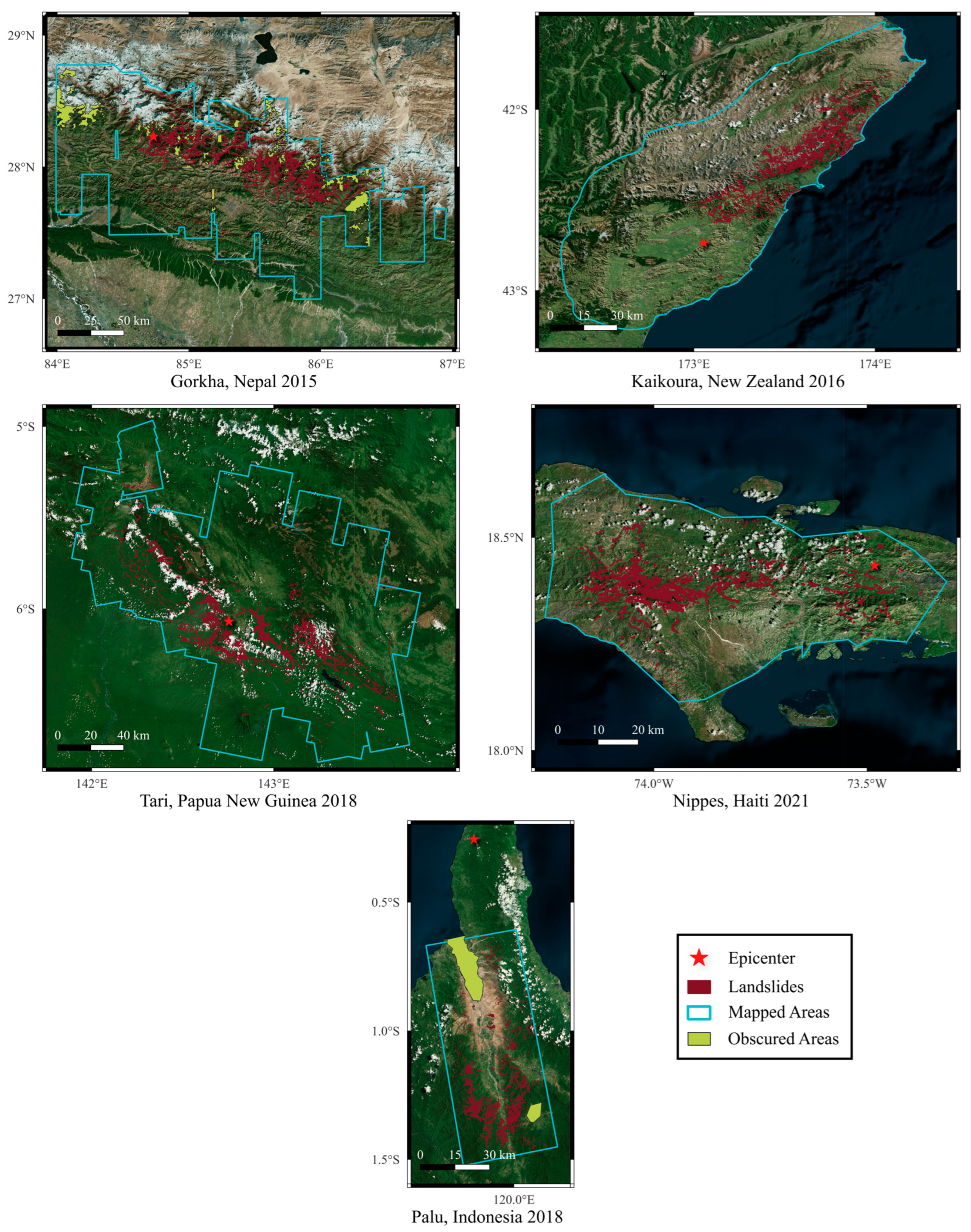


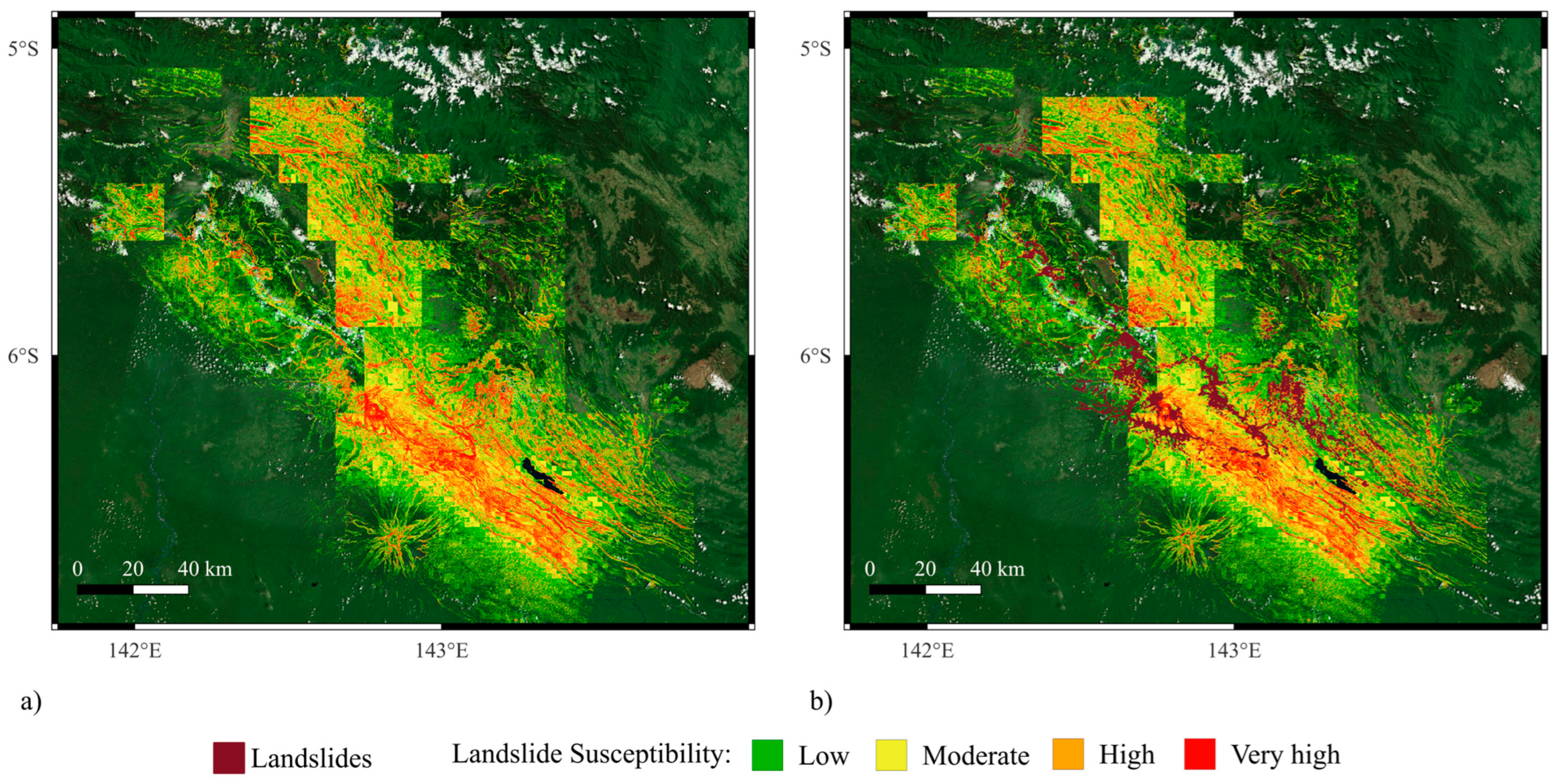
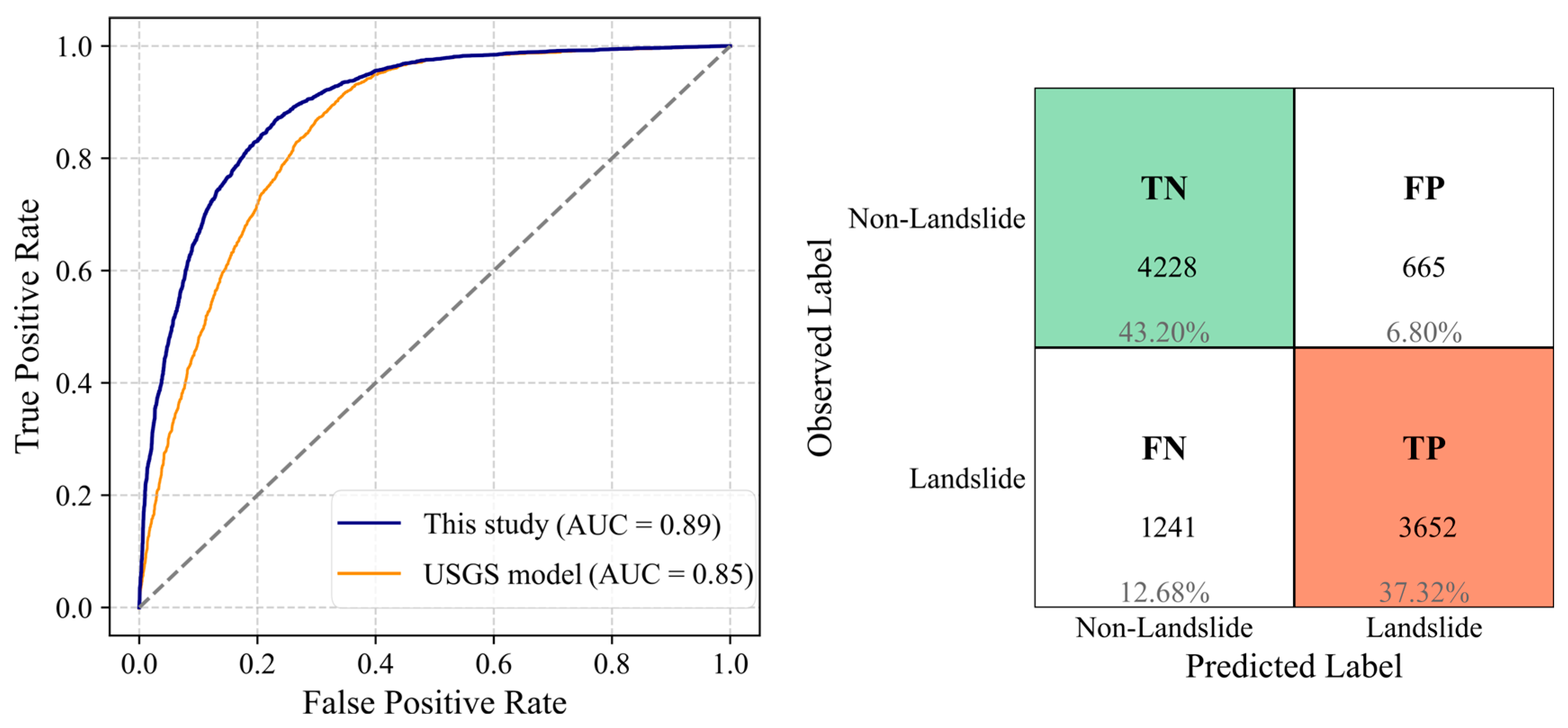
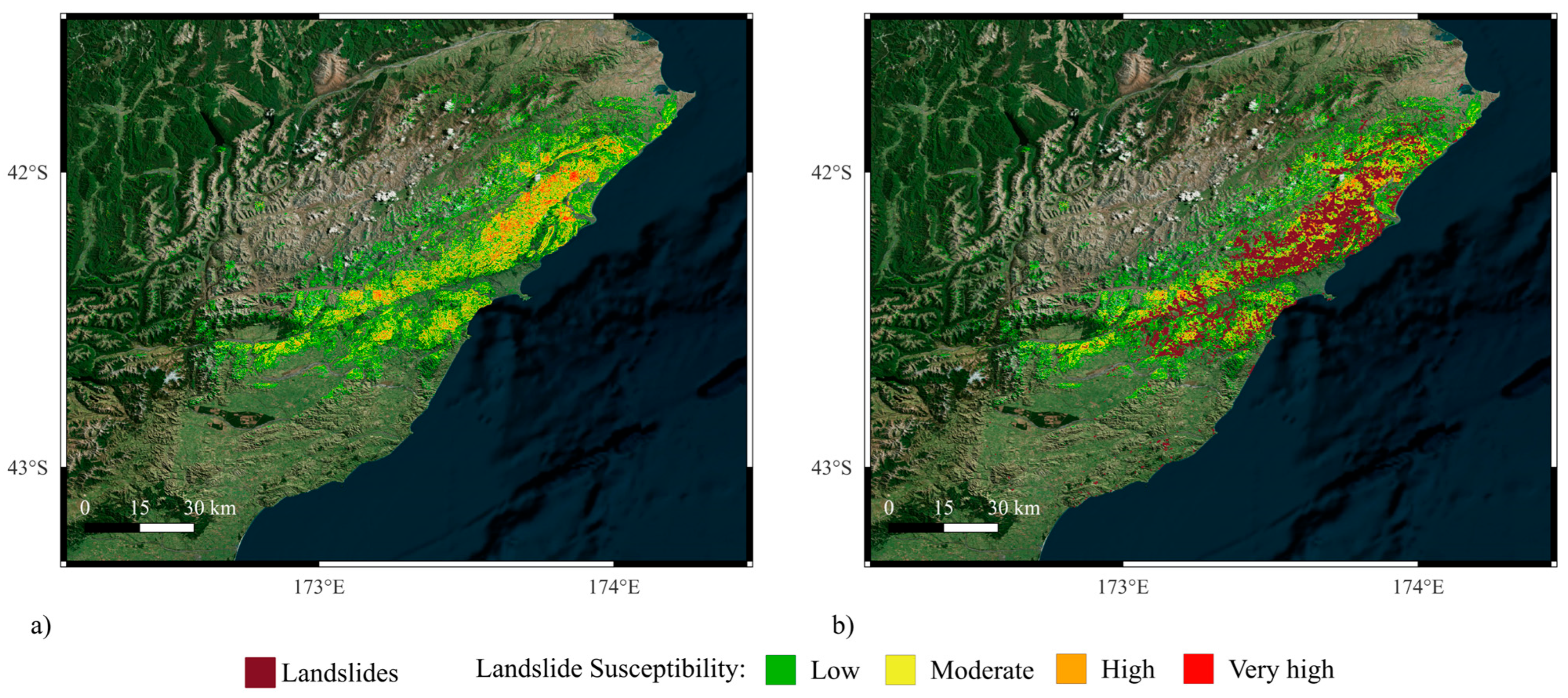
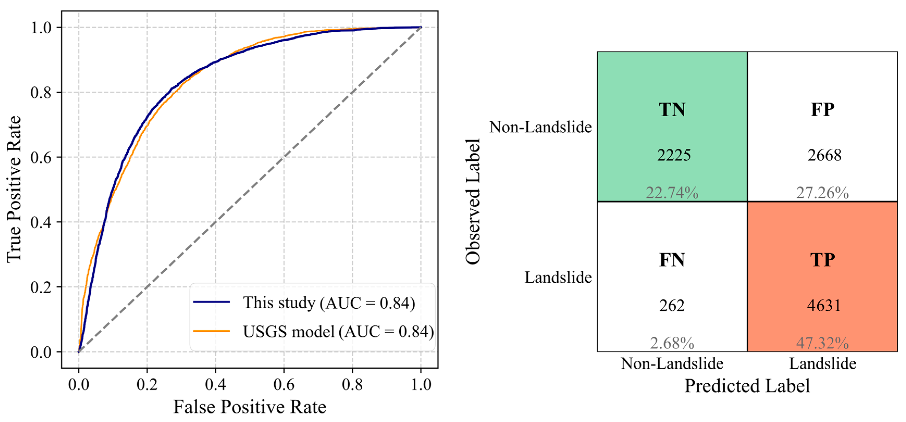
| Landslide Inventory | Magnitude | Area Exposed to Landslides (km2) | Number of Landslide Cases | Number of Non-Landslide Cases |
|---|---|---|---|---|
| Nippes, Haiti 2021 | 7.2 | 4000 | 4893 | 4893 |
| Palu, Indonesia 2018 | 7.5 | 4000 | 7063 | 7063 |
| Tari, Papua New Guinea 2018 | 7.5 | 24,000 | 11,610 | 11,610 |
| Kaikoura, New Zealand 2016 | 7.8 | 10,000 | 14,412 | 14,412 |
| Gorkha, Nepal 2015 | 7.8 | 30,000 | 24,843 | 24,843 |
| Category | Variable Name (s) | Source |
|---|---|---|
| Topographic and Geological | Elevation, Slope, TRI, TPI | Digital Elevation Model (STRM) |
| VS30 | [131] | |
| Land Cover | Esri Sentinel-2 | |
| Ground Shaking Intensity | PGA, GV | USGS |
| Wetness Proxies | TWI, STI | Digital Elevation Model (STRM) |
| Historical Precip | World Clim database | |
| GPM precipitation | GPM Rain 1yr, 3mo, 1mo, 2w, 1w | Giovanni |
| SMAP—Prior-event Normalized Soil Moisture | RSM 1mo Avg, 2w Avg, 1w Avg, 3d Avg SSM L4 1mo Avg, 2w Avg, 1w Avg, 3d Avg SSM L3 1mo Avg, 2w Avg, 1w Avg RSM Pre, SSM L4 Pre, SSM L3 Pre | National Snow and Ice Data Center |
| SMAP—Short-Term Change Ratio | %Δ RSM (Pre − 1w Avg), RSM (3d Ave − 2w Avg), %Δ RSM (3d Ave − 1mo Avg) %Δ SSM L4 (Pre − 1w Avg), %Δ SSM L4 (3d Ave − 2w Avg), %Δ SSM L4 (3d − 1mo) | |
| SMAP—Lag-Based Changes | %Δ SSM L4 (Pre − Day−3/7/10/14), %Δ RSM (Pre − Day−3/7/10/14) |
| Variable | VIF |
|---|---|
| PGV | 8.2 |
| Slope | 7.1 |
| Elevation | 3.4 |
| LC | 2.9 |
| TWI | 1.8 |
| Δ% RSM (Pre – Day–14) | 2.9 |
| SSM L4 1w Avg | 7.8 |
| GPM Rain 1w | 4.1 |
| Left-Out Landslide Inventory | AUC | Accuracy | Precision | Recall | F1-Score |
|---|---|---|---|---|---|
| Nippes, Haiti 2021 | 0.84 | 0.75 | 0.72 | 0.83 | 0.77 |
| Palu, Indonesia 2018 | 0.83 | 0.77 | 0.78 | 0.76 | 0.77 |
| Tari, Papua New Guinea 2018 | 0.89 | 0.81 | 0.83 | 0.76 | 0.80 |
| Kaikoura, New Zealand 2016 | 0.89 | 0.80 | 0.84 | 0.75 | 0.79 |
| Gorkha, Nepal 2015 | 0.84 | 0.70 | 0.63 | 0.95 | 0.76 |
| Average in this study | 0.86 | 0.76 | 0.76 | 0.81 | 0.78 |
Disclaimer/Publisher’s Note: The statements, opinions and data contained in all publications are solely those of the individual author(s) and contributor(s) and not of MDPI and/or the editor(s). MDPI and/or the editor(s) disclaim responsibility for any injury to people or property resulting from any ideas, methods, instructions or products referred to in the content. |
© 2025 by the authors. Licensee MDPI, Basel, Switzerland. This article is an open access article distributed under the terms and conditions of the Creative Commons Attribution (CC BY) license (https://creativecommons.org/licenses/by/4.0/).
Share and Cite
Farahani, A.; Ghayoomi, M. A Soil Moisture-Informed Seismic Landslide Model Using SMAP Satellite Data. Remote Sens. 2025, 17, 2671. https://doi.org/10.3390/rs17152671
Farahani A, Ghayoomi M. A Soil Moisture-Informed Seismic Landslide Model Using SMAP Satellite Data. Remote Sensing. 2025; 17(15):2671. https://doi.org/10.3390/rs17152671
Chicago/Turabian StyleFarahani, Ali, and Majid Ghayoomi. 2025. "A Soil Moisture-Informed Seismic Landslide Model Using SMAP Satellite Data" Remote Sensing 17, no. 15: 2671. https://doi.org/10.3390/rs17152671
APA StyleFarahani, A., & Ghayoomi, M. (2025). A Soil Moisture-Informed Seismic Landslide Model Using SMAP Satellite Data. Remote Sensing, 17(15), 2671. https://doi.org/10.3390/rs17152671


