


Soil Moisture Prediction Using Remote Sensing and Machine Learning Algorithms: A Review on Progress, Challenges, and Opportunities


Abstract

1. Introduction
2. Research Methodology
3. Results and Discussion
3.1. Suitability of ML Models in SM Estimation
3.2. Satellite/UAV/Ground-Based Observation for SM Estimation
3.3. ML Model Performance on Single Source and Multi-Source Data
3.4. Important Features

| Author | Study Area/Scale | ML Technique | Satellites/UAV | Input Features | In Situ SM Measured Method | In Situ SM Depth (cm) | Best ML Model |
|---|---|---|---|---|---|---|---|
| Ahmad et al. [99] | USA, Regional | SVM, MLR, ANN | TRMM, AVHRR | Incident angle, σ°, NDVI | Electrical resistance | 10 | SVM |
| Araya et al. [100] | USA, Regional | ANN, SVR, RVR, RF, BRT | UAV | Precipitation *, red band *, ET *, TPI *, curvature, NIR, green band, flow accumulation, slope, aspect, direction | TDR | 4 | BRT |
| Guan et al. [57] | USA, Field | RF | UAV | NDVI, NDRE *, GNDVI, CIG, VARI *, raw multispectral bands, crop type, drainage condition | GPR | 18 | RF |
| Khedri et al. [101] | USA, Regional | SVR | AIRSAR | Coherent and non-Coherent decomposition of PolSAR images | - | - | - |
| Liang et al. [102] | USA, Regional | GA-BPNN | GNSS-IR | Relative phase | - | SSM | - |
| Nabi et al. [103] | USA, Global | CNN | CYGNSS, SMAP, MODIS | Analog power, effective scattering area, BRCS, incident angle, peak reflectivity, NDVI, VWC, slope, water percentage, elevation, clay, silt. | - | SSM | - |
| Ren et al. [104] | USA, Regional | LS-SVM | GNSS-IR | Relative phase of multi-satellite | - | - | - |
| Senyurek et al. [105] | USA, Field | RF | UAV | Carrier-to-noise density ratio (C/N0), elevation, azimuth angle, NDVI, VWC | HOBO SM probe | SSM | - |
| Torres-Rua et al. [106] | USA, Field | RVM | Landsat 7 | Blue, green, red, NIR *, SWIR1, SWIR2, 7, Red/NIR *, NDVI, GNDVI, BNDVI, NBR, brightness, greenness, wetness, haze, NDWI, LAI *, α, ε, energy balance products from METRIC * | Decagon GS3 sensor | SSM | - |
| Xu et al. [107] | USA, Regional | GRNN | SMAP | SMAP brightness temperatures | - | 10 | - |
| Akhavan et al. [79] | Canada, Field | GRNN, NN, SVR | Sentinel-1 | VV, VH, entropy, alpha, GLCM | - | 5 | GRNN |
| Dabboor et al. [108] | Canada, Regional | ANN, DT, SVM, GPR, Ensemble Learning | RADARSAT | Radar backscattering coefficients (RH and RV), incident angle | Stevens HydraProbe | 5 | GPR |
| Jiaxin et al. [109] | Canada. Field | ERT, XGBoost, GPR, GRNN | Sentinel-1, Sentinel-2, Landsat 8, PLSA | VV, VH, VH/VV, RIA, PRVI, DpRVI, H, α, A, blue, green, red, NIR, SWIR1 *, SWIR2 *, TAv, TAh, MPDI *, STT *, SOM *, SR | - | 5 | GPR |
| Chen et al. [110] | Canada, Field | SVM, RF, GBM | RADARSAT-2, Sentinel-2 | VH, VV *, HH *, HV, Polarimetric parameters | Theta-probe SM sensor | 5 | RF |
| Lee et al. [111] | Canada, Regional | DNN | Sentinel-1, Sentinel-2 | VV, incidence angle *, elevation *, Sentinel-2 bands 2–8, band 8A, band 11, band 12, NDVI, EVI, SAVI, MSI, and NDWI, crop type *, month *. | Stevens HydraProbe | 5 | - |
| Liu et al. [112] | Canada, Field | RF, SVR, DNN, GRNN | Landsat 8, Sentinel-2, Sentinel -1, Gaofen-1 RADARSAT-2 | SRWI *, NDVI, DVI, EVI *, MSAVI, CRI1, MRENDVI, MRERSR *, S2REP, TVI, IRECI, MTIC, MTCC, CIred edge, NDVIre3 *, MCARI, MCARI2, TCARI, SWIRI2 *, MSI, NDMI, NMCI, VV *, VH *, VV-VH *, VV/VH, incident angle | Probe-based and the core-based | 5 | DNN |
| Zhang et al. [113] | Canada, Field | Quantile regression forest | UAV SAR | SERD, DERD, normalized, reference and actual backscattering, HH, VV, HV, coefficients, surface, double-bounce, volume | FDR | 6 | - |
| Filgueiras et al. [114] | Brazil, Field | LR, RF, PLS, PCA, GBR, Cubist | MODIS | Irrigation depth, Kc, ETo, solar radiation, NDVI, simple ratio | Soil water balance equation | SSM | RF |
| Cheng et al. [91] | China, Field | PLSR, KNN, RF, BPNN | UAV | CC, MSR, NDVI, OSAVI, RV1, RV12, SAVI, SIPI, TVI, EVI, MCARI, NPCI, GI, GNDVI, SRPI, NPCI, NDVIgb, PSRI, VARI, CIVE, VA, NRCT, TVDI, VA, CO, EN, COR, ME, HO, DS, SM. | TDR | 10, 20 | RF |
| Ge et al. [115] | China, Field | RF, ELM | UAV | NDVI *, NDVI705 *, RVI, NDCI, GNDVI, OSAVI, NDRE, mNDVI705, VOG1, VOG3, VOG2, CARI, MTVI1, TVI, DVI, RDVI, SPVI, WI/NDVI, EVI, NVI, MSAVI *, WI, REP, PRI, MTVI2, TCARI2, TCARI/OSAVI, MCARI/OSAVI, TCARI1, MCARI | Oven drying | 10 | RF |
| Ge et al. [116] | China, Field | XGBoost | UAV | Difference index (DI), ratio index (RI), normalized difference index (NDI) | Gravimetric method | 10 | |
| Guo et al. [94] | China, Field | SVM, GRNN, CNNR | UAV | NDVI, DVI, MSAVI, rectified average value (Av), kurtosis (Ku), root mean square (Rm), peak factor (C), pulse (I) | TR-6D Soil Thermometer | 6 | CNNR |
| Guo et al. [117] | China, Field | MLR, BPNN, SVM | Sentinel-1, Sentinel-2 | VV, VH, salinity index, NDVI, EVI, MSAVI, NDVIre, BI, intensity index, PDI, SMMI | Oven drying | 20 | SVM |
| Han et al. [118] | China, Regional | CART | MODIS | LST, ET, NDVI, precipitation, soil texture, elevation, Soil AWC, FC | - | 10 | |
| Hou et al. [119] | China, Field | RF, SVR, ANN | Sentinel-1 | VV, VH, incident angle, polarimetric parameters | TDR | 7 | RF |
| Hu et al. [120] | China, Field | LR, BPNN, GA-BPNN | GNSS-R | Signal to noise ratio | Hygrometer | 7.5 | GA-BPNN |
| Li and Yan [121] | China, Regional | RF, XGBoost, LightGBM, CatBoost, DNN, CNN, GRU, Stacking | Sentine-1, Sentinel-2 | VV, VH, NDVI, GNDVI, MNDWI, NBRI, RVI, SATVI, SAVI, B2, B3, B4, B8, B11, B12, elevation *, latitude *, longitude *, month_cos, month_sin | Decagon 5TM | 5 | Stacking |
| Li et al. [76] | China, Regional | RF, GBR, RF-GBR | Sentinel-2 | Band 1–8 | Oven drying | 20–30 | RF-GBR |
| Li et al. [122] | China, Regional | Deep Forest, RF, GRNN, GBRT, SVM, KNN | Sentinel-1, Sentinel-2 | VV *, VH, NDVI *, NDWI, clay *, sand, BD, land cover, fractional cover, longitude *, elevation * | Decagon 5TM ECH2O | 5 | Deep Forest |
| Zhang et al. [123] | China, Regional | BPNN, XGBoost, LSR, RF | MODIS, SMAP, ERA-Interim, ERA5-Land | NDVI, LST *, Land cover, reflectance, albedo, latitude, longitude, SMAP_TBH *, SMAP_TBV *, ERA_SR *, ERA_Eva, ERA_Runoff, ERA_TP, elevation, T_Clay, T_Sand, T_Silt, SOC, DOY | - | SSM | BPNN |
| Liu et al. [124] | China, Regional | RF, Extra Tree, LR | GF-1, Landsat 8, GF-4 | COSRI *, DVI, EVI, GDVI, GLI, FNDVI, GOSAVI, GRVI, GSAVI, IPVI, MSAVI2, NDVI, NNIR, NR, OSAVI, RI, RVI, TVI, VARI, WDRI | Decagon 5TM SM sensor | 3, 10, 20 | Extra Tree |
| Zhang et al. [125] | China, Field | Copula Quantile Regression | RADARSAT-2 | HH, VV, HV, VH, entropy, alpha, anisotropy, adaptive non-negative eigenvalue decomposition (odd, Dbl, Vol) | SPADE and Hydra Probe | 4 | - |
| Lv et al. [69] | China, Regional | RF, SVM, BPNN, Stacking | Landsat-9 | NDVI, RVI, DVI, SAVI, EVI, GVI, SI-T, S1, S2, S3, NDSI, bright, green, wet, albedo, NDWI, NDBI, elevation | Oven drying | 10 | Stacking |
| Wang et al. [126] | China, Regional | PR, Ridge regression, LASSO, Elastic net, RF | Fengyun-3C, MODIS | FY-3C SM *, NDVI *, months, latitude *, longitude, elevation, clay, sand, silt | - | 10 | RF |
| Mu et al. [127] | China, Regional | LR, BPNN | GF-2, GF-3, GF-5 | Bands normalization of GF-2, GF-3, and GF-5 | Oven drying | 10 | BPNN |
| Wang et al. [71] | China, Regional | CART, RF, GBDT, ERT, Stacking | Landsat, Sentinel -1 | VV *, VH, NDVI, EVI, SAVI, RVI, IPVI, LST, albedo, elevation, slope, SLIA, TVDI *, VSDI, VSWI, NIR, SWIR1, SWIR2, surface temperature * | Oven drying | 10 | Stacking |
| Qiao et al. [128] | China, Field | RBF, Multivariate RBF | Ground penetration radar | GPR signals | - | SSM | |
| Wang et al. [64] | China, Field | RF, GRNN, CNN, SSA-CNN | Sentinel-1, Sentinel-2 | Incident angle, VH, VV, scattering entropy, inverse entropy, α, eigenvalues (λ1 *, λ2), Zs), NDVI *, NDWI, MSI *, FVI * | TDR | 3.8 | SSA-CNN |
| Taghavi-Bayat et al. [129] | China, Regional | DRF | Sentinel-1 | S-1:TFGVV *, TFGVH, LIA, SAR-VI: PRVI, DpRVI *, SAR-VI: DPSVI, mDPSVI *, RVI *, elevation, slope, TRI, TI, flow direction, curvature, SM, soil temperature, diurnal temperature range, minimum temperature, maximum temperature, daily rainfall events, days of year * | - | 5 | - |
| Tao et al. [72] | China, Regional | CatBoost, RF, GBDT, Stacking | MODIS | VCI, NDWI, NDVI, EVI, TCI *, CWSI *, VSWI, elevation * | - | SSM | Stacking |
| Jiang et al. [130] | China, Regional | RBFNN, LSTM, RNN, PCA-LSTM | - | RH, Ta, soil temperature, U, wind direction, rainfall, light intensity | - | SSM | PCA-LSTM |
| Xiaoxia et al. [131] | China, Regional | BPNN | Fengyun-3B, MODIS | LST, NDVI, albedo, NDVI, elevation | - | SSM | - |
| Xiang-yu et al. [132] | China, Field | GBR, RF, XGBoost | UAV | DI, NDI, RI, PI | - | 10 | XGBoost |
| Xu et al. [133] | China, Regional | GABP, SVR, RF | Sentinel-1, Sentinel-2, TerraSAR | Incident angle, VV, VH, HH, NDVI, NDWI | TDR | SSM | RF |
| Jiang et al. [134] | China, Regional | PCR, PLSR, BPNN | ASD Field Spec FR spectrometer | EVI, TVI, DSI, NDMI, SARVI | - | 20 | BPNN |
| Yang et al. [135] | China, Regional | DBN | Sentinel-1, Landsat 8 | VV, VH, incident angle, EVI, OSAVI, elevation, slope, aspect | - | 10 | - |
| Yang et al. [136] | China, Regional | RF, ERT, XGBoost, LightGBM | MODIS, SMAP, TRIMS | NDVI, NDWI, DDI, SM, LST | - | 10 | LightGBM |
| Zhang et al. [75] | China, Regional | DI-Conv GRU, LSTM, Interp-ConvGRU, DI-LSTM | SMAP | SM from SMAP, precipitation, Ta, Rs, RH, U, sand, silt, clay content, BD, land cover, elevation | - | 5 | DI_Conv GRU |
| Zhang et al. [137] | China, Regional | RF, SVM, GA-BP | Sentinel-1, Sentinel-2 | NDVI *, NDWI, RVI, MSI, WBI, FVI, Zs, average scattering angle *, θ *, cos(θ) *, sin(θ) *, VV, VH, inverse entropy, scattering entropy | TDR | SSM | RF |
| Zhang et al. [138] | China, Field | PLSR, KNN, RF | UAV | SAVI, NDVI, TCARI, VARI, OSAVI, SIPI, MCSARI, NDVIgb, PSRI, CIVE, MCARI/OSAVI, TCARI/OSAVI, NRCT, TVDI, GLCM features | Oven drying | 10, 20 | RF |
| Zhang et al. [139] | China, Regional | DFNN | VIIRS-RDR | Sixteen moderate resolution bands (M1–M16) | Gravimetric method | 10 | |
| Zhan et al. [140] | China, Regional | MLR, AdaBoost, RF, GBM | Sentinel-2 | MTCI, MNDVI, PSRI, RENDVI, S2REP, IRECI, OSAVI, SAVI red, MSR, soil textures | Oven drying | 10 | GBM |
| Chaudhary et al. [141] | India, Field | SVM, RF, MLP, RBF, WM, SBC, ANFIS, HyFIS, DENFIS | Sentinel-1 | VH, VV | Steven’s HydraGo | SSM | SBC |
| Das et al. [142] | India, Field | Cubist, GBM, RF, Stacking | Landsat, Sentinel -1 | shadowMin, shadowMax, NDVI, TVI, TTVI, SR, EVI2, CTVI, GEMI, RVI, MSAVI2, SAVI, NRVI, SLAVI, MSAVI, WDVI, DVI, B5_sre, Sigma0_VH, NDWI2, B6_sre, B4_sre, B2_sre, B3_sre, GNDVI, NDWI, SATVI, B7_sre *, NBRI *, LST *, MNDWI *, Sigma0_VV * | ML3 ThetaProbe | 5 | Stacking |
| Datta et al. [143] | India, Regional | LR, MLR, RF, KNN, SVM | Sentinel-1, Sentinel-2 | VV *, VH | Oven drying | 5 | RF |
| Khose and Mailapalli [144] | India, Field | LR, KNN, RF, DT, SVR | UAV | NDVI, NDWI, TNDVI, Simple Ratio or Ratio Vegetation Index (RVI), SAVI, PDI. | Gravimetric method | 1, 5 | LR, SVR |
| Nijaguna et al. [73] | India, Regional | DMN-Bi-GRU | Sentinel-1, Sentinel-2 | NDVI, GLAI, GNDVI, WDRVI | - | SSM | DMN-Bi-GRU |
| Pal and Maity [145] | India, Regional | RF, SVN, GP | Radar Imaging Satellite 1 (RISAT1) | HH *, HV, VH, VV, sand, silt, clay | Gravimetric method | 5 | GP |
| Singh and Gaurav [61] | India, Regional | ANN, GRNN, RBN, ERBN, GPR, SVR, RF, Boosting, RNN, RNNBDT, AutoML | Sentinel-, Sentinel-2 | VV, VH, VH/VV, VH-VV, angle, NDVI, elevation, longitude, latitude | ML3 theta probe | 5 | ANN |
| Singh et al. [66] | India, Regional | LR, SVR, DT, RF, LSTM | SMAP | SSM, LST, soil texture, land cover, wind direction, U, surface pressure, dew point, Ta, precipitation | - | 5 | LSTM |
| Lee et al. [96] | South Korea, Regional | DNN | MODIS | OLR, Isolation accumulated precipitation (12 h, 24 h), NDVI, Ta, RH, Land cover, elevation, slope | SM probes | 10 | - |
| Lee et al. [146] | South Korea, Regional | RF, AutoML | IMERG, GK2A, VIIRS, LDAPS, SRTM | 10- and 20-day cumulative standardized precipitation indexes (SPI10 * and SPI20 *), NDVI, DSR, Ta, LST, soil temperature, RH, LE, slope *, elevation *, TRI, aspect. | TDR | 10 | AutoML |
| Adab et al. [92] | Iran, Regional | RF, SVM, ANN, EN | Landsat 7, 8 | LST *, blue *, green, red, NIR *, SWIR1, SWIR2 | Capacitance Probe | 10 | RF |
| Asadollah et al. [74] | Iran, Regional | GBM, SVR, GBM-SVR | GLDAS, AMSR2, SMAP | AMSR2-C1, AMSR2-C2, ASMR2-X, SMAPL3, SMAPL4, GLDAS * | TDR | 6 | GBM-SVR |
| Bandak et al. [147] | Iran, Regional | RF, SVR, XGBoost, Extra tree | Sentinel-2, Landsat 8 | Salinity index -S1, Salinity index -S2, Salinity index -S3, Salinity index -S4, Salinity index -S5, NDSI *, NDVI, SAVI, VSSI, NDWI *, Extended EVI, MNDWI * | Oven drying | 10 | Extra tree |
| Fathololoumi et al. [148] | Iran, Regional | RF, Cubist | Landsat 8 | Elevation, aspect-sin, aspect-cos, catchment area, convergence index, maximum difference of mean elevation, general curvature, hill shade, MSP, MRRTF, LS, total curvature, albedo *, emissivity *, LST *, Incidence | Portable SM meter | SSM | RF, Cubist |
| Hemmati and Sahebi [63] | Iran, Regional | RF, SVR, MLP, CNN | Sentinel-1, Sentinel-2 | VV, VH, incident angle, NDVI | Thetaprobe sensor | 5 | CNN |
| Karamvand et al. [149] | Iran, Regional | ELM | SMAP, MODIS | Precipitation, NDVI, LST | - | 5 | - |
| Moosavi et al. [150] | Iran, Regional | PSO-ANFIS, PSO-SVR | MODIS, Landsat 8 | Evaporative fraction, TVDI, VTCI, STVDI, TVX | - | SSM | PSO-SVR |
| Moosavi et al. [151] | Iran, Regional | PSO-CMAC, PSO-GMDH | Sentinel-2 | NDVI, NDWI, all bands from Sentinel-2, slope, aspect, elevation | TDR | 5 | PSO-CMAC |
| Moosavi et al. [70] | Iran, Regional | LSTM, CNN, CNN-LSTM | Sentinel-2 | NDVI, NDWI, NDMI, BSI, elevation, slope, aspect, TWI, land use, soil properties | TDR | 8 | CNN-LSTM |
| Nouraki et al. [152] | Iran, Regional | MLR, CART, M5P, GBM, RF | Landsat | Blue, green, red, NIR, SWIR1, SWIR2, LST, NDVI, NSMI, NTR, SWI, sand, silt, clay, BD | - | 10 | RF, GBM |
| Tahmouresi et al. [153] | Iran, Regional | RF, GBM, XGBoost | SMAP, AMSR2, MODIS | Elevation, slope, sand, silt, LST, SSM, NDVI, precipitation | TDR | 5 | XGBoost, GBM |
| Shokati et al. [154] | Iran, Field | M5 tree, RF, SMOreg, MLP | UAV | DI, RI, NDI, PI | Gravimetric method | 5 | RF |
| Pasolli et al. [58] | Switzerland, Field | SVR, MLP | Radiometer–scatterometer | VV, VH, emissivity polarizations, incident angle | Oven drying | SSM | SVR |
| Kseneman et al. [155] | Slovenia, Regional | FFBP Neural Network | TerraSAR-X | Backscatter coefficients | TRIME-PICO64 | 5 | - |
| Pongrac and Gleich [156] | Slovenia, Regional | CNN | ALOS-2 | - | - | SSM | - |
| Jia et al. [157] | Italy, Regional | RF, SVM | GNSSR | Reflectivity, elevation angle | - | SSM | RF |
| Notarnicola et al. [158] | Italy, Regional | SVR | ASAR WS sensor, MODIS, GEOtop | VV, VH, slope, elevation, aspect, land cover, soil type | - | SSM | - |
| Pasolli et al. [159] | Italy, Regional | SVR | RADARSAT-2, Envisat ASAR, MODIS | HH, HV, HV/VV, altitude *, incident angle, NDVI *, land use | TDR | 5 | SVR |
| Santi et al. [160] | Italy, Regional | ANN | Sentinel-1, SMAP | Brightness temperature, acquisition geometry, land use, NDVI | - | SSM | - |
| Portal et al. [161] | Spain, Regional | ANN | Sentinel-2, MODIS, ERA5, ESA CCI | Precipitation, reflectance, LST, elevation, slope, SM, land cover, NDVI, NDRE, EVI, GNDVI, SAVI, NDMI, MSI, NBRI, BSI, NDWI | - | 10 | - |
| Chen et al. [162] | Spain, Field | 1D-CNN | Spectrophotometer | Spectral measurement from different soil samples | Oven drying | SSM | - |
| Abebrese et al. [163] | Czech Republic, Field | XGBoost | Sentinel-2 | NDVI, NDRI, NDWI, DVI, RVI, MSI, elevation | EC-5 Sensor | 5–10 | - |
| Lendzioch et al. [164] | Czech Republic, Field | RF | UAV | RGI, VVI, VDVI, VARI, TGI, SI, SHP, SCI, SAT, NGRDI, NDTI, NDI, HI, GRVI, GLI, GLAI, ExG, ERGBVE, CI, BI, RI, HUE, NDVI, Slope, ProfCurv, PlnCurv, WEI, TRI (1, 4), VRM (1, 4), TPI, TWI, Temperature, GWL, SM. | Oven drying | SSM | - |
| Hajdu et al. [80] | New Zealand, Regional | RF | Sentinel-1 | Backscatter, incident angle, NDVI, slope, aspect, roughness index, wetness index | Capacitance-based, AquaCheck sub-surface probes | 10 | - |
| Holtgrave et al. [165] | Germany, Regional | SVR | Sentinel-1, Landsat | VV, VH *, incident angle, NDVI *, height *, slope, and aspect | FDR | SSM | - |
| Morellos et al. [166] | Germany, Field | LS-SVM, Cubist | Spectrophotometer | VIS-NIR reflection | Oven drying | 20 | LS-SVM |
| Schröter et al. [167] | Germany, Regional | Fuzzy c-means sampling and estimation approach (FCM SEA) | LIDAR | Elevation | - | 10 | - |
| Schröter et al. [168] | Germany, Field | Fuzzy c-means sampling and estimation approach (FCM SEA) | RapidEye sensor | reNDVI, elevation, LAI | TDR | 10 | - |
| Özerdem et al. [169] | Turkey, Regional | GRNN | RADARSAT-2 | VV, VH, HV, HH, entropy, anisotropy, alpha angle, volume scattering, odd bounce, double bounce | Gravimetric method | 3–5 | - |
| Şekertekin, Marangoz [170] | Turkey, Regional | MLR | Sentinel-1 | VV, VH, incident angle | Oven drying | SSM | |
| Usta [98] | Turkey, Regional | ANN | Landsat 8 | EVI, SAVI, NDMI, MNDVI, MSI, SMI, TIRS 1, TIRS2, slope *, TWI *, ALT, TPI *, TRASP, EAST *, NORTH, SITE, CTI | - | 0–10, 10–20 | - |
| Huang et al. [171] | Austria, Regional | Deep belief network | Landsat, MODIS, SMAP, ERA-5 | LST, NDVI, albedo, precipitation, SMAP SM, ERA-5 SM | - | 5 | - |
| Ayehu et al. [172] | Ethiopia, Regional | SCA, SVM | Sentinel-1, MODSI, SRTM | VV, VH, NDVI, elevation | - | SSM | SCA |
| Ayehu et al. [173] | Ethiopia, Field | LR, ANN | Sentinel-1, Landsat 7 and 8 | VV, surface heights (hrms), surface correlation length (leff) | FDR | 5 | ANN |
| Attarzadeh et al. [174] | Kenya, Regional | SVR | Sentinel-, Sentinel-2 | VV, GLCM Contrast, GLCM Correlation, GLCM Dissimilarity, GLCM Entropy, GLCM Homogeneity, GLCM Mean, GLCM Standard Dev, GLCM Angular, SAVI, NDVI, TSAVI, MSAVI, MSAVI2, DVI *, RVI, PVI, IPVI, WDVI, TNDVI, GNDVI *, GEMI *, ARVI, NDI45, MTCI, MCARI, REIP, S2REP, IRECI, PSSRa, LAI, FCOVER *, NDWI, NDWI2, BI, BI2, RI, CI | TDR | 5 | - |
| Dutta and Terhorst [175] | Australia, Regional | S-ANFIS, MLP, PNN, RBFN | CosmOz Cosmic Ray Sensor | Neutron counts from cosmic ray probe, rainfall, Ta, RH | - | 0–5, 10–15, 25–30 | S-ANFIS |
| Celik et al. [67] | Global | LSTM | Sentinel-1, Sentinel-, SMAP | VV, VH, SSM, soil textures *, elevation, slope, aspect, hill shade, Ta, ET, precipitation * | - | 10 | - |
| Nativel et al. [82] | Global | ANN | Sentinel-1, Sentinel-2 | VV *, VH *, the classical change detection SSM index ISSM, incidence angle *, NDVI *, VH/VV ratio * | - | 10 | - |
| Jia et al. [176] | Global | XGBoost, ANN, SVM, RF | CYGNSS, SMAP | Reflectivity from CYGNSS, vegetation opacity, and roughness coefficients from SMAP | - | SSM | XGBoost |
| Rodríguez-Fernández et al. [177] | Global | Neural Network | SMOS | RH, Ta, ASCAT SM, LST, snow cover, snow temperature, brightness temperature | - | 5 | |
| Senyurek et al. [178] | Global | RF | CYGNSS, MODIS | Reflective power, incident angle, trailing edge slope, NDVI, vegetation water content, elevation, slope, soil properties | - | SSM | - |
| Zhang et al. [59] | Global | RF, XGBoost | SMAP, ERA5, Landsat | Landsat 8 (5 VNIR bands, 2 SWIR bands, 2 TIR bands, solar elevation, angle), elevation *, slope, aspect *, sand *, silt, clay *, precipitation, surface skin temperature, ERA-5 SM * | - | SSM | XGBoost |
| Hamidisepehr et al. [179] | Global | 20 different ML models available in MATLAB | Spectrometers | 1024 wavelengths into 20 components using Partial Least Square regression. | - | 0.64, 1.92, 3.20, 4.48, 5.76 | Cubic SVM |
| Jia et al. [180] | Global | RF | GNSS-R | Signal-to-noise ratio, elevation angle | - | SSM | RF |
| Lei et al. [60] | Global | RF | CYGNSS, MODIS | CYGNSS reflectivity, trailing edge slope, specular point incidence angle, NDVI, vegetation water content, elevation, clay, silt | - | SSM | RF |
| Lei et al. [181] | Global | RF | CYGNSS, SMAP | Reflectivity, TES, incidence angle, elevation, NDVI, VWC, silt, clay | - | 10 | |
| Nabi et al. [182] | Global | CNN | CYGNSS, SMAP, MODIS | Analog power, effective scattering area, BRCS VWC, NDVI, elevation, slope, water percentage, clay, silt | - | 10 | |
| Roberts et al. [183] | Global | CNN | CYGNSS, SMAP | DDM, VWC, elevation, surface water occurrence | - | SSM | - |
| Wang et al. [184] | Global | ANN | Fengyun, SMAP | Brightness temperature, microwave vegetation index | - | 5 | - |
| Zhang et al. [185] | Global | RF | MODIS | LST *, LST difference, NDVI, EVI, API *, clay, sand, silt, latitude *, longitude * | - | SSM | |
| Zhu et al. [186] | Global | Transfer Learning | SMAP, Sentinel-1, MODIS | VV, VH, incident angles, sand, clay, BD, elevation, slope, aspect, NDVI, Ta, precipitation, day of year | - | 5 | - |
| Li et al. [187] | China and USA | Deep and parallel model | Sentine-1, Sentinel-2 | VV, VV+VH, incident angle, NDVI, elevation, land covers, soil properties | - | SSM | - |
| Fang et al. [188] | United States and Mexico | Fully CNN (FCNN) | MODIS, SMAP | NDVI, LST, SSM | - | 10 | |
| Hegazi et al. [81] | Australia and Austria | CNN | Sentinel-1 | Sigma0_VH and Sigma0_VV or Gamma0_VH and Gamma0_VV or Beta0_VH and Beta0_VV | Campbell Scientific water content reflectometers | 20 | - |
| Hegazi et al. [65] | Australia and Austria | CNN | Sentinel-2 | B1-B12 bands (B1—Coastal aerosol, B2—Blue, B3—Green, B4—Red, B5—Vegetation red edge *, B6—Vegetation red edge, B7—Vegetation red edge, B8—NIR, B8A—Narrow NIR, B9—Water vapor, B10—SWIR—Cirrus, B11—SWIR *, B12—SWIR) | Campbell Scientific water content reflectometers and TDR | 30 | - |
| Eroglu et al. [93] | USA and Australia | ANN | CYGNSS | Surface reflectivity, TES, and SP incidence angle, NDVI, VWC, elevation, slope, h-parameters. | - | SSM | - |
| Tsagkatakis et al. [189] | USA and Switzerland | CNN | SMAP | SSM | - | SSM | - |
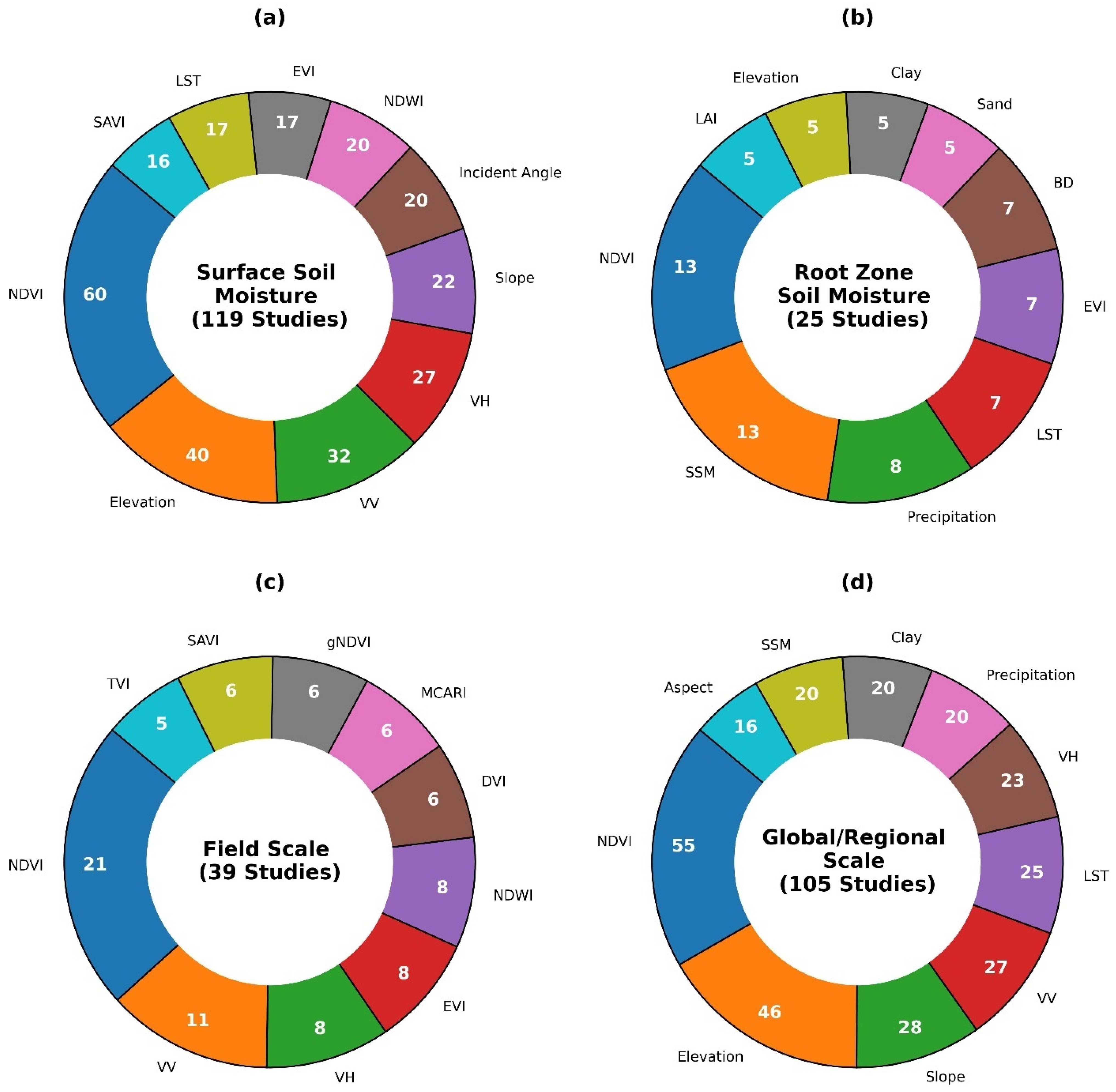
3.4.1. SSM and RZSM Prediction
| Author | Study Area/Scale | ML Technique | Satellites/UAV | Input Features | In Situ SM Measured Method | In Situ SM Depth (cm) | Best ML Model |
|---|---|---|---|---|---|---|---|
| Babaeian et al. [86] | USA, Field | AutoML (NN, GBM, GLM, DRF) | UAV | NTR, NDVI, texture, BD, OC, θfc, θpwp, Ksat, ϕ, SSM | TDR | 2, 10, 50 | NN |
| Karthikeyan and Mishra [95] | USA, Regional | XGBoost | MODIS, SMAP | SM and SSM from SMAP, sand, silt, clay, BD, NDVI, EVI, LST, precipitation, elevation | - | 5, 10, 20, 50, 100 | - |
| Kisekka et al. [196] | USA, Field | RF | Landsat 7 and 8 | NDVI *, elevation *, BD *, soil temperature *, Rs, RH, ET, U, precipitation, evaporation fraction * | TDR | 30, 60, 90 | - |
| Peng et al. [86] | USA, Regional | Quantile RF | Sentinel-1, SMAP, Landsat-8, MODIS | VV, VH, near infrared, thermal bands, LST, SSM, elevation, land cover, terrain attributes | TEROS 12, Meter Group | 50, 100 | - |
| Sahaar and Niemann [83] | USA, Regional | ANN, RF, XGBoost, CatBoost, LightGBM | SMAP, GPM, ECOSTRESS, MODIS | SSM, RZSM, PSM, NCLD, NDVI, EVI, LAI, fPAR, sand, silt, clay *, OM, BD, EC, pH, precipitation, LST, ET, AI *, elevation *, slope, aspect, hill shade, TPI | - | 5, 10, 20, 50, 100 | XGBoost |
| Xia et al. [197] | USA, Regional | Quantile RF | NLDAS, MODIS, PRISM, SRTM | NLDAS based SM *, LST, NDWI, EVI, GPP, BD *, SOC *, precipitation, Ta, VPD, elevation, slope *, aspect *, vertical, horizontal, and mean curvatures, TWI, surface roughness, land cover, tree cover percentage | - | 5, 10, 20, 50, 100 | - |
| Zeng et al. [191] | USA, Regional | RF | SMOS, MODIS, TRMM | SMOS SM *, vertically polarized brightness, horizontally polarized brightness *, ET, PET, NR, NDVI, LST, LST gap, TVDI, precipitation, soil properties, elevation, slope | - | 5, 25, 60 | - |
| A et al. [85] | China, Regional | ConvLSTM | MODIS, GLDAS | Precipitation, Ta, BD, SSM, ETa, NDVI, LAI, SSM * | Gravimetric Method | 5, 10, 20, 40, 60, 80 | - |
| A et al. [198] | China, Regional | RF | MODIS, ASTER | LAI, PET, LST | - | 3, 5, 10, 20, 50 | |
| Luo et al. [199] | China, Field | RLR, RLSSVM, RELM | GF-1 | soil brightness index *, four salinity indices (SI, SI1, SI2, SI3) *, EVI, ARVI, SAVI2 *, TSAVI, PDI | Oven drying | 20, 40, 60 | RELM |
| Ma et al. [97] | China, Regional | RF | MODIS | NDVI, ET, albedo, LST *, sand *, silt *, clay, elevation, slope *, aspect *, precipitation, SMC | - | 5–80 | - |
| Zeng et al. [192] | China, regional | RF, LightGBM, XGBoost | ERA5, ESA-CCI, CSSPv2, GLDASv2.1 | Elevation *, latitude *, longitude *, clay, sand, OM, Ta, specific humidity, U, surface pressure, precipitation, solar radiation, SM of ERA5, GLDASv2.1, ESA-CCI | FDR | 0–100 | - |
| Zhu et al. [87] | China, Field | RF, SVM, ELM | UAV | NDVI, NDRE, SCCI, RVI, NDCI, GNDVI, OSAVI1, OSAVI2, VOG1, CARI, CARI717, CARI740, MTVI1, TVI, DVI, RDVI, SPVI, EVI1, EVI2, EVI3, MSAVI1, MSAVI2, REP1, PRI, MTVI2, TCARI1, TCARI2, TCARI1, OSAVI1, OSAVI2, MCARI, TCARI, MCARI, MSAVI1, OSAVI1, OSAVI2, MCARI, TCARI1, SAVI, VARI, GLI, IPVI, NNIR, GCI, RECI, WDRVI. | FDR-TRIME | 10, 20, 30, 40, 60 | RF |
| Li et al. [200] | China, Regional | RF | ERA5-Land, MODIS | Precipitation, Ta, evaporation *, LAI, ERA5-Land SM *, rock fragment, porosity, sand, silt, clay *, land cover type, elevation * | - | 0–100 | |
| Tang et al. [201] | China, Regional | RF, SVM, BPNN, ELM | ASD Field-Spec 3 portable field hyper spectral spectrometer | Spectral reflectance | Oven drying | 0–20, 20–40, 40–60 | RF |
| Yin et al. [88] | China, Field | PLSR, SVR, RF, DNN | UAV | Raw bands, GRVI, NDVI, GNDVI, NDRE, SIPI, SAVI, OSAVI, MSR, MCARI, TCARI, EVI, NDREI, CH, VF, CWSI, TVDI, NCRT, GLCM | Oven drying | 30 | DNN |
| Zhu et al. [202] | China, Field | RF, GBR, XGBoost, LightGBM, CataBoost | UAV | SAVI, SMMI, MSAVI, MSMMI, EVI, MTVI | FDR-TRIME | 0–10, 10–20, 20–30, 30–40, 40–50, 50–60 | XGBoost |
| Zhu et al. [89] | China, Field | RF, GBR, XGBoost, LightGBM, CatBoost | UAV | NDVI, EVI, CWSI, TDVI, TDDI | FDR-TRIME | 0–10, 10–20, 20–30, 30–40, 40–50, 50–60 | CatBoost |
| Zhu et al. [62] | China, Regional | MLR, RF, ANN | MODIS | SWC, Ts *, albedo *, ET *, NDVI *, clay, sand, SOC, BD, hydraulic conductivity, slope | neutron-probe | 0–5 m | ANN |
| Manninen et al. [203] | Finland, Regional | GBM | Sentinel-1 | VV, VH, altitude, aspect, local slope angle, incident angle, cos(θ), LAI, time difference between the SM measurement and SAR image acquisition, azimuth difference of radar looking direction and terrain slope | WET-2 and PR2 Profile Probe | SSM, 10, 20, 30, 40 cm | - |
| Joshi et al. [204] | Australia, Regional | LightGBM | MODIS | Ta, Rs, RH, rainfall, latitude, longitude, MODIS bands, LST, soil properties | - | 1–6 m | - |
| Efremova et al. [205] | Australia, Regional | RF, LR, MLP, SVM, Ridge Regression, Kernel Ridge Regression | Sentinel-1, Sentinel-2 | Sentinel-1 and Sentinel-2 images | Embedded SM sensors | 10–120 | RF |
| Fuentes et al. [206] | Australia, Regional | MLP | Sentinel-1, MODIS, SMAP | VV, relative SSM, LST, NDVI, land cover, clay, SOC, AWC | TDR | 0–30, 30 to 60 | |
| Madhukumar et al. [68] | Australia, Regional | LSTM, Hybrid-GRU, Multi-head TNN, Hybrid TNN | SMAP, MODIS | SSM, soil moisture indices, weather variables | - | 80 | - |
| Souissi et al. [207] | Global | ANN | MODIS | NDVI *, SST, SWI *, SSM | - | 30, 55 | - |
3.4.2. Input Features for Field Scale vs. Regional/Global Scale
3.5. Impact of Vegetation Cover on Microwave-Based Soil Moisture Estimation
3.6. ML Model Transferability Challenges and Solutions
3.7. In Situ SM Measuring Techniques and Uncertainty
3.8. Uncertainty and Future Research Directions in SM Estimation
4. Conclusions
Supplementary Materials
Funding
Data Availability Statement
Conflicts of Interest
References
- Shiklomanov, I.A. Appraisal and Assessment of World Water Resources. Water Int. 2000, 25, 11–32. [Google Scholar] [CrossRef]
- Wasko, C.; Nathan, R.; Peel, M.C. Changes in Antecedent Soil Moisture Modulate Flood Seasonality in a Changing Climate. Water Resour. Res. 2020, 56, e2019WR026300. [Google Scholar] [CrossRef]
- Hassan-Esfahani, L.; Torres-Rua, A.; Jensen, A.; Mckee, M. Assessment of Surface Soil Moisture Using High-Resolution Multi-Spectral Imagery and Artificial Neural Networks. Remote Sens. 2015, 7, 2627–2646. [Google Scholar] [CrossRef]
- Phillips, A.J.; Newlands, N.K.; Liang, S.H.L.; Ellert, B.H. Integrated sensing of soil moisture at the field-scale: Measuring, modeling and sharing for improved agricultural decision support. Comput. Electron. Agric. 2014, 107, 73–88. [Google Scholar] [CrossRef]
- Zhang, Y.; Parazoo, N.C.; Williams, A.P.; Zhou, S.; Gentine, P. Large and projected strengthening moisture limitation on end-of-season photosynthesis. Proc. Natl. Acad. Sci. USA 2020, 117, 9216–9222. [Google Scholar] [CrossRef]
- Jackson, T.J. Remote sensing of soil moisture: Implications for groundwater recharge. Hydrogeol. J. 2002, 10, 40–51. [Google Scholar] [CrossRef]
- Dorigo, W.; De Jeu, R.; Chung, D.; Parinussa, R.; Liu, Y.; Wagner, W.; Fernández-Prieto, D. Evaluating global trends (1988–2010) in harmonized multi-satellite surface soil moisture. Geophys. Res. Lett. 2012, 39, L18405. [Google Scholar] [CrossRef]
- Hillel, D. Introduction to Environmental Soil Physics; Elsevier: Amsterdam, The Netherlands, 2003. [Google Scholar]
- Ma, Y.; Van Dam, R.L.; Jayawickreme, D.H. Soil moisture variability in a temperate deciduous forest: Insights from electrical resistivity and throughfall data. Environ. Earth Sci. 2014, 72, 1367–1381. [Google Scholar] [CrossRef]
- Rosenbaum, U.; Bogena, H.R.; Herbst, M.; Huisman, J.A.; Peterson, T.J.; Weuthen, A.; Western, A.W.; Vereecken, H. Seasonal and event dynamics of spatial soil moisture patterns at the small catchment scale. Water Resour. Res. 2012, 48, W10544. [Google Scholar] [CrossRef]
- Coenders-Gerrits, A.M.J.; Hopp, L.; Savenije, H.H.G.; Pfister, L. The effect of spatial throughfall patterns on soil moisture patterns at the hillslope scale. Hydrol. Earth Syst. Sci. 2013, 17, 1749–1763. [Google Scholar] [CrossRef]
- Fu, B.; Wang, J.; Chen, L.; Qiu, Y. The effects of land use on soil moisture variation in the Danangou catchment of the Loess Plateau, China. Catena 2003, 54, 197–213. [Google Scholar] [CrossRef]
- Gerrits, A.M.J.; Pfister, L.; Savenije, H.H.G. Spatial and temporal variability of canopy and forest floor interception in a beech forest. Hydrol. Process. 2010, 24, 3011–3025. [Google Scholar] [CrossRef]
- Liang, W.-L.; Hung, F.-X.; Chan, M.-C.; Lu, T.-H. Spatial structure of surface soil water content in a natural forested headwater catchment with a subtropical monsoon climate. J. Hydrol. 2014, 516, 210–221. [Google Scholar] [CrossRef]
- Baroni, G.; Ortuani, B.; Facchi, A.; Gandolfi, C. The role of vegetation and soil properties on the spatio-temporal variability of the surface soil moisture in a maize-cropped field. J. Hydrol. 2013, 489, 148–159. [Google Scholar] [CrossRef]
- Chen, M.; Willgoose, G.R.; Saco, P.M. Spatial prediction of temporal soil moisture dynamics using HYDRUS-1D. Hydrol. Process. 2014, 28, 171–185. [Google Scholar] [CrossRef]
- Vereecken, H.; Huisman, J.A.; Pachepsky, Y.; Montzka, C.; van der Kruk, J.; Bogena, H.; Weihermüller, L.; Herbst, M.; Martinez, G.; Vanderborght, J. On the spatio-temporal dynamics of soil moisture at the field scale. J. Hydrol. 2014, 516, 76–96. [Google Scholar] [CrossRef]
- Hopp, L.; McDonnell, J.J. Connectivity at the hillslope scale: Identifying interactions between storm size, bedrock permeability, slope angle and soil depth. J. Hydrol. 2009, 376, 378–391. [Google Scholar] [CrossRef]
- Martinez, C.; Hancock, G.R.; Kalma, J.D.; Wells, T. Spatio-temporal distribution of near-surface and root zone soil moisture at the catchment scale. Hydrol. Process. 2008, 22, 2699–2714. [Google Scholar] [CrossRef]
- Western, A.W.; Zhou, S.-L.; Grayson, R.B.; McMahon, T.A.; Blöschl, G.; Wilson, D.J. Spatial correlation of soil moisture in small catchments and its relationship to dominant spatial hydrological processes. J. Hydrol. 2004, 286, 113–134. [Google Scholar] [CrossRef]
- Wilson, D.J.; Western, A.W.; Grayson, R.B. A terrain and data-based method for generating the spatial distribution of soil moisture. Adv. Water Resour. 2005, 28, 43–54. [Google Scholar] [CrossRef]
- Western, A.W.; Grayson, R.B.; Blöschl, G. Scaling of soil moisture: A hydrologic perspective. Annu. Rev. Earth Planet. Sci. 2002, 30, 149–180. [Google Scholar] [CrossRef]
- Li, B.; Rodell, M. Spatial variability and its scale dependency of observed and modeled soil moisture over different climate regions. Hydrol. Earth Syst. Sci. 2013, 17, 1177–1188. [Google Scholar] [CrossRef]
- Feng, Q.; Zhao, W.; Qiu, Y.; Zhao, M.; Zhong, L. Spatial Heterogeneity of Soil Moisture and the Scale Variability of Its Influencing Factors: A Case Study in the Loess Plateau of China. Water 2013, 5, 1226–1242. [Google Scholar] [CrossRef]
- Gaur, N.; Mohanty, B.P. Evolution of physical controls for soil moisture in humid and subhumid watersheds. Water Resour. Res. 2013, 49, 1244–1258. [Google Scholar] [CrossRef]
- Famiglietti, J.S.; Ryu, D.; Berg, A.A.; Rodell, M.; Jackson, T.J. Field observations of soil moisture variability across scales. Water Resour. Res. 2008, 44, W01423. [Google Scholar] [CrossRef]
- Laguardia, G.; Niemeyer, S. On the comparison between the LISFLOOD modelled and the ERS/SCAT derived soil moisture estimates. Hydrol. Earth Syst. Sci. 2008, 12, 1339–1351. [Google Scholar] [CrossRef]
- Noborio, K. Measurement of soil water content and electrical conductivity by time domain reflectometry: A review. Comput. Electron. Agric. 2001, 31, 213–237. [Google Scholar] [CrossRef]
- Srivastava, P.K.; Han, D.; Ramirez, M.A.R.; Islam, T. Appraisal of SMOS soil moisture at a catchment scale in a temperate maritime climate. J. Hydrol. 2013, 498, 292–304. [Google Scholar] [CrossRef]
- Zazueta, F.S.; Xin, J. Soil Moisture Sensors; Florida Cooperative Extension Service: Gainesville, FL, USA, 1994. [Google Scholar]
- Sharma, P.; Kumar, D.; Srivastava, H.S. Assessment of Different Methods for Soil Moisture Estimation: A Review. J. Remote Sens. GIS 2018, 9, 57–73. [Google Scholar]
- Munoth, P.; Goyal, R.; Garg, A. Estimation of Soil Moisture and Its Application to Irrigation Water Allocation: A Review. In Proceedings of the International Conference on Hydraulics, Water Resources and Coastal Engineering (Hydro2016), Pune, India, 8–10 December 2016; CWPRS: Pune, India, 2016. [Google Scholar]
- Huisman, J.A.; Bouten, W.; Verstraten, J.M. Soil water content measurements at different scales: Accuracy of time domain reflectometry and ground-penetrating radar. J. Hydrol. 2001, 245, 48–58. [Google Scholar] [CrossRef]
- Petropoulos, G.P.; Ireland, G.; Barrett, B. Surface soil moisture retrievals from remote sensing: Current status, products & future trends. Phys. Chem. Earth Parts A/B/C 2015, 83–84, 36–56. [Google Scholar] [CrossRef]
- Jones, S.B.; Wraith, J.M.; Or, D. Time domain reflectometry measurement principles and applications. Hydrol. Process. 2002, 16, 141–153. [Google Scholar] [CrossRef]
- Tarantino, A.; Ridley, A.M.; Toll, D.G. Field Measurement of Suction, Water Content, and Water Permeability. Geotech. Geol. Eng. 2008, 26, 751–782. [Google Scholar] [CrossRef]
- Wagner, W.; Blöschl, G.; Pampaloni, P.; Calvet, J.-C.; Bizzarri, B.; Wigneron, J.-P.; Kerr, Y. Operational readiness of microwave remote sensing of soil moisture for hydrologic applications. Hydrol. Res. 2007, 38, 1–20. [Google Scholar] [CrossRef]
- Mohanty, B.P.; Cosh, M.H.; Lakshmi, V.; Montzka, C. Soil Moisture Remote Sensing: State-of-the-Science. Vadose Zone J. 2017, 16, 1–9. [Google Scholar] [CrossRef]
- Vereecken, H.; Huisman, J.; Bogena, H.; Vanderborght, J.; Vrugt, J.; Hopmans, J. On the value of soil moisture measurements in vadose zone hydrology: A review. Water Resour. Res. 2008, 44, W00D06. [Google Scholar] [CrossRef]
- Zhang, D.; Zhou, G. Estimation of Soil Moisture from Optical and Thermal Remote Sensing: A Review. Sensors 2016, 16, 1308. [Google Scholar] [CrossRef]
- Gillies, R.R.; Carlson, T.N. Thermal Remote Sensing of Surface Soil Water Content with Partial Vegetation Cover for Incorporation into Climate Models. J. Appl. Meteorol. Climatol. 1995, 34, 745–756. [Google Scholar] [CrossRef]
- Njoku, E.G.; Kong, J.-A. Theory for passive microwave remote sensing of near-surface soil moisture. J. Geophys. Res. 1977, 82, 3108–3118. [Google Scholar] [CrossRef]
- Schmugge, T. Remote sensing of surface soil moisture. J. Appl. Meteorol. (1962–1982) 1978, 17, 1549–1557. [Google Scholar] [CrossRef]
- Sandholt, I.; Rasmussen, K.; Andersen, J. A simple interpretation of the surface temperature/vegetation index space for assessment of surface moisture status. Remote Sens. Environ. 2002, 79, 213–224. [Google Scholar] [CrossRef]
- Dutta, R. Remote Sensing of Energy Fluxes and Soil Moisture Content. J. Spat. Sci. 2015, 60, 196–197. [Google Scholar] [CrossRef]
- Schmugge, T.; Jackson, T.J. Mapping surface soil moisture with microwave radiometers. Meteorol. Atmos. Phys. 1994, 54, 213–223. [Google Scholar] [CrossRef]
- Qin, J.; Yang, K.; Lu, N.; Chen, Y.; Zhao, L.; Han, M. Spatial upscaling of in-situ soil moisture measurements based on MODIS-derived apparent thermal inertia. Remote Sens. Environ. 2013, 138, 1–9. [Google Scholar] [CrossRef]
- Filion, R.; Bernier, M.; Paniconi, C.; Chokmani, K.; Melis, M.; Soddu, A.; Talazac, M.; Lafortune, F.-X. Remote sensing for mapping soil moisture and drainage potential in semi-arid regions: Applications to the Campidano plain of Sardinia, Italy. Sci. Total Environ. 2016, 543, 862–876. [Google Scholar] [CrossRef]
- Anne, N.J.; Abd-Elrahman, A.H.; Lewis, D.B.; Hewitt, N.A. Modeling soil parameters using hyperspectral image reflectance in subtropical coastal wetlands. Int. J. Appl. Earth Obs. Geoinf. 2014, 33, 47–56. [Google Scholar] [CrossRef]
- Minacapilli, M.; Agnese, C.; Blanda, F.; Cammalleri, C.; Ciraolo, G.; D’Urso, G.; Iovino, M.; Pumo, D.; Provenzano, G.; Rallo, G. Estimation of actual evapotranspiration of Mediterranean perennial crops by means of remote-sensing based surface energy balance models. Hydrol. Earth Syst. Sci. 2009, 13, 1061–1074. [Google Scholar] [CrossRef]
- Kornelsen, K.C.; Coulibaly, P. Advances in soil moisture retrieval from synthetic aperture radar and hydrological applications. J. Hydrol. 2013, 476, 460–489. [Google Scholar] [CrossRef]
- Engman, E.T. Progress in Microwave Remote Sensing of Soil Moisture. Can. J. Remote Sens. J. Can. Télédétect. 1990, 16, 6–14. [Google Scholar] [CrossRef]
- Kerr, Y.H.; Al-Yaari, A.; Rodriguez-Fernandez, N.; Parrens, M.; Molero, B.; Leroux, D.; Bircher, S.; Mahmoodi, A.; Mialon, A.; Richaume, P.; et al. Overview of SMOS performance in terms of global soil moisture monitoring after six years in operation. Remote Sens. Environ. 2016, 180, 40–63. [Google Scholar] [CrossRef]
- Entekhabi, D.; Njoku, E.G.; O’Neill, P.E.; Kellogg, K.H.; Crow, W.T.; Edelstein, W.N.; Entin, J.K.; Goodman, S.D.; Jackson, T.J.; Johnson, J.; et al. The Soil Moisture Active Passive (SMAP) Mission. Proc. IEEE 2010, 98, 704–716. [Google Scholar] [CrossRef]
- Colliander, A.; Jackson, T.J.; Bindlish, R.; Chan, S.; Das, N.; Kim, S.B.; Cosh, M.H.; Dunbar, R.S.; Dang, L.; Pashaian, L.; et al. Validation of SMAP surface soil moisture products with core validation sites. Remote Sens. Environ. 2017, 191, 215–231. [Google Scholar] [CrossRef]
- Karthikeyan, L.; Pan, M.; Wanders, N.; Kumar, D.N.; Wood, E.F. Four decades of microwave satellite soil moisture observations: Part 1. A review of retrieval algorithms. Adv. Water Resour. 2017, 109, 106–120. [Google Scholar] [CrossRef]
- Guan, Y.; Grote, K.; Schott, J.; Leverett, K. Prediction of Soil Water Content and Electrical Conductivity Using Random Forest Methods with UAV Multispectral and Ground-Coupled Geophysical Data. Remote Sens. 2022, 14, 1023. [Google Scholar] [CrossRef]
- Pasolli, L.; Notarnicola, C.; Bruzzone, L. Estimating Soil Moisture with the Support Vector Regression Technique. IEEE Geosci. Remote Sens. Lett. 2011, 8, 1080–1084. [Google Scholar] [CrossRef]
- Zhang, Y.; Liang, S.; Zhu, Z.; Ma, H.; He, T. Soil moisture content retrieval from Landsat 8 data using ensemble learning. ISPRS J. Photogramm. Remote Sens. 2022, 185, 32–47. [Google Scholar] [CrossRef]
- Lei, F.; Senyurek, V.; Kurum, M.; Gurbuz, A.; Moorhead, R.; Boyd, D. Machine-Learning Based Retrieval of Soil Moisture at High Spatio-Temporal Scales Using CYGNSS and SMAP Observations. In Proceedings of the IGARSS 2020—2020 IEEE International Geoscience and Remote Sensing Symposium, Waikoloa, HI, USA, 26 September–2 October 2020; pp. 4470–4473. [Google Scholar]
- Singh, A.; Gaurav, K. Deep learning and data fusion to estimate surface soil moisture from multi-sensor satellite images. Sci. Rep. 2023, 13, 2251. [Google Scholar] [CrossRef]
- Zhu, Z.; Zhao, C.; Jia, X.; Wang, J.; Shao, M. Prediction of deep soil water content (0–5 m) with in-situ and remote sensing data. Catena 2023, 222, 106852. [Google Scholar] [CrossRef]
- Hemmati, E.; Sahebi, M.R. Surface soil moisture retrieval based on transfer learning using SAR data on a local scale. Int. J. Remote Sens. 2024, 45, 2374–2406. [Google Scholar] [CrossRef]
- Wang, R.; Zhao, J.; Yang, H.; Li, N. Inversion of Soil Moisture on Farmland Areas Based on SSA-CNN Using Multi-Source Remote Sensing Data. Remote Sens. 2023, 15, 2515. [Google Scholar] [CrossRef]
- Hegazi, E.H.; Samak, A.A.; Yang, L.; Huang, R.; Huang, J. Prediction of Soil Moisture Content from Sentinel-2 Images Using Convolutional Neural Network (CNN). Agronomy 2023, 13, 656. [Google Scholar] [CrossRef]
- Singh, T.; Kundroo, M.; Kim, T. WSN-Driven Advances in Soil Moisture Estimation: A Machine Learning Approach. Electronics 2024, 13, 1590. [Google Scholar] [CrossRef]
- Celik, M.F.; Isik, M.S.; Yuzugullu, O.; Fajraoui, N.; Erten, E. Soil Moisture Prediction from Remote Sensing Images Coupled with Climate, Soil Texture and Topography via Deep Learning. Remote Sens. 2022, 14, 5584. [Google Scholar] [CrossRef]
- Madhukumar, N.; Wang, E.; Everingham, Y.; Xiang, W. Hybrid Transformer Network for Soil Moisture Estimation in Precision Irrigation. IEEE Access 2024, 12, 48898–48909. [Google Scholar] [CrossRef]
- Lv, W.; Hu, X.; Li, X.; Zhao, J.; Liu, C.; Li, S.; Li, G.; Zhu, H. Multi-Model Comprehensive Inversion of Surface Soil Moisture from Landsat Images Based on Machine Learning Algorithms. Sustainability 2024, 16, 3509. [Google Scholar] [CrossRef]
- Moosavi, V.; Zuravand, G.; Rashid Fallah Shamsi, S. Cluster-based local modeling (CBLM) paradigm meets deep learning: A novel approach to soil moisture estimation. J. Hydrol. 2024, 635, 131161. [Google Scholar] [CrossRef]
- Wang, S.; Wu, Y.; Li, R.; Wang, X. Remote sensing-based retrieval of soil moisture content using stacking ensemble learning models. Land Degrad. Dev. 2022, 34, 911–925. [Google Scholar] [CrossRef]
- Tao, S.; Zhang, X.; Feng, R.; Qi, W.; Wang, Y.; Shrestha, B. Retrieving soil moisture from grape growing areas using multi-feature and stacking-based ensemble learning modeling. Comput. Electron. Agric. 2023, 204, 107537. [Google Scholar] [CrossRef]
- Nijaguna, G.S.; Manjunath, D.R.; Abouhawwash, M.; Askar, S.S.; Basha, D.K.; Sengupta, J. Deep Learning-Based Improved WCM Technique for Soil Moisture Retrieval with Satellite Images. Remote Sens. 2023, 15, 2005. [Google Scholar] [CrossRef]
- Asadollah, S.B.H.S.; Sharafati, A.; Saeedi, M.; Shahid, S. Estimation of soil moisture from remote sensing products using an ensemble machine learning model: A case study of Lake Urmia Basin, Iran. Earth Sci. Inform. 2023, 17, 385–400. [Google Scholar] [CrossRef]
- Zhang, Y.; Huang, F.; Li, L.; Li, Q.; Zhang, Y.; Shangguan, W. Real-Time Forecast of SMAP L3 Soil Moisture Using Spatial–Temporal Deep Learning Model with Data Integration. Remote Sens. 2023, 15, 366. [Google Scholar] [CrossRef]
- Li, X.; Wu, J.; Yu, J.; Zhou, Z.; Wang, Q.; Zhao, W.; Hu, L. Inversion of Soil Moisture Content in Cotton Fields Using GBR-RF Algorithm Combined with Sentinel-2 Satellite Spectral Data. Agronomy 2024, 14, 784. [Google Scholar] [CrossRef]
- Soudani, K.; Delpierre, N.; Berveiller, D.; Hmimina, G.; Vincent, G.; Morfin, A.; Dufrêne, É. Potential of C-band Synthetic Aperture Radar Sentinel-1 time-series for the monitoring of phenological cycles in a deciduous forest. Int. J. Appl. Earth Obs. Geoinf. 2021, 104, 102505. [Google Scholar] [CrossRef]
- Gharechelou, S.; Tateishi, R.; Sumantyo, J.T.S. Interrelationship analysis of L-band backscattering intensity and soil dielectric constant for soil moisture retrieval using PALSAR data. Adv. Remote Sens. 2015, 4, 15–24. [Google Scholar] [CrossRef]
- Akhavan, Z.; Hasanlou, M.; Hosseini, M.; Becker-Reshef, I. Soil moisture retrieval improvement over agricultural fields by adding entropy–alpha dual-polarimetric decomposition features. J. Appl. Remote Sens. 2021, 15, 034516. [Google Scholar] [CrossRef]
- Hajdu, I.; Yule, I.; Dehghan-Shear, M.H. Modelling of near-surface soil moisture using machine learning and multi-temporal sentinel 1 images in New Zealand. In Proceedings of the IGARSS 2018—2018 IEEE International Geoscience and Remote Sensing Symposium, Valencia, Spain, 22–27 July 2018; pp. 1422–1425. [Google Scholar]
- Hegazi, E.H.; Yang, L.; Huang, J. A Convolutional Neural Network Algorithm for Soil Moisture Prediction from Sentinel-1 SAR Images. Remote Sens. 2021, 13, 4964. [Google Scholar] [CrossRef]
- Nativel, S.; Ayari, E.; Rodriguez-Fernandez, N.; Baghdadi, N.; Madelon, R.; Albergel, C.; Zribi, M. Hybrid Methodology Using Sentinel-1/Sentinel-2 for Soil Moisture Estimation. Remote Sens. 2022, 14, 2434. [Google Scholar] [CrossRef]
- Sahaar, S.A.; Niemann, J.D. Estimating Rootzone Soil Moisture by Fusing Multiple Remote Sensing Products with Machine Learning. Remote Sens. 2024, 16, 3699. [Google Scholar] [CrossRef]
- Peng, Y.; Yang, Z.; Zhang, Z.; Huang, J. A Machine Learning-Based High-Resolution Soil Moisture Mapping and Spatial–Temporal Analysis: The mlhrsm Package. Agronomy 2024, 14, 421. [Google Scholar] [CrossRef]
- A, Y.; Wang, G.; Hu, P.; Lai, X.; Xue, B.; Fang, Q. Root-zone soil moisture estimation based on remote sensing data and deep learning. Environ. Res. 2022, 212, 113278. [Google Scholar] [CrossRef]
- Babaeian, E.; Paheding, S.; Siddique, N.; Devabhaktuni, V.K.; Tuller, M. Estimation of root zone soil moisture from ground and remotely sensed soil information with multisensor data fusion and automated machine learning. Remote Sens. Environ. 2021, 260, 112434. [Google Scholar] [CrossRef]
- Zhu, S.; Cui, N.; Zhou, J.; Xue, J.; Wang, Z.; Wu, Z.; Wang, M.; Deng, Q. Digital Mapping of Root-Zone Soil Moisture Using UAV-Based Multispectral Data in a Kiwifruit Orchard of Northwest China. Remote Sens. 2023, 15, 646. [Google Scholar] [CrossRef]
- Yin, L.; Yan, S.; Li, M.; Liu, W.; Zhang, S.; Xie, X.; Wang, X.; Wang, W.; Chang, S.; Hou, F. Enhancing soil moisture estimation in alfalfa root-zone using UAV-based multimodal remote sensing and deep learning. Eur. J. Agron. 2024, 161, 127366. [Google Scholar] [CrossRef]
- Zhu, S.; Cui, N.; Jin, H.; Jin, X.; Guo, L.; Jiang, S.; Wu, Z.; Lv, M.; Chen, F.; Liu, Q.; et al. Optimization of multi-dimensional indices for kiwifruit orchard soil moisture content estimation using UAV and ground multi-sensors. Agric. Water Manag. 2024, 294, 108705. [Google Scholar] [CrossRef]
- Shakhatreh, H.; Sawalmeh, A.H.; Al-Fuqaha, A.; Dou, Z.; Almaita, E.; Khalil, I.; Othman, N.S.; Khreishah, A.; Guizani, M. Unmanned aerial vehicles (UAVs): A survey on civil applications and key research challenges. IEEE Access 2019, 7, 48572–48634. [Google Scholar] [CrossRef]
- Cheng, M.; Jiao, X.; Liu, Y.; Shao, M.; Yu, X.; Bai, Y.; Wang, Z.; Wang, S.; Tuohuti, N.; Liu, S. Estimation of soil moisture content under high maize canopy coverage from UAV multimodal data and machine learning. Agric. Water Manag. 2022, 264, 107530. [Google Scholar] [CrossRef]
- Adab, H.; Morbidelli, R.; Saltalippi, C.; Moradian, M.; Ghalhari, G.A.F. Machine Learning to Estimate Surface Soil Moisture from Remote Sensing Data. Water 2020, 12, 3223. [Google Scholar] [CrossRef]
- Eroglu, O.; Kurum, M.; Boyd, D.; Gurbuz, A.C. High Spatio-Temporal Resolution CYGNSS Soil Moisture Estimates Using Artificial Neural Networks. Remote Sens. 2019, 11, 2272. [Google Scholar] [CrossRef]
- Guo, J.; Bai, Q.; Guo, W.; Bu, Z.; Zhang, W. Soil moisture content estimation in winter wheat planting area for multi-source sensing data using CNNR. Comput. Electron. Agric. 2022, 193, 106670. [Google Scholar] [CrossRef]
- Karthikeyan, L.; Mishra, A.K. Multi-layer high-resolution soil moisture estimation using machine learning over the United States. Remote Sens. Environ. 2021, 266, 112706. [Google Scholar] [CrossRef]
- Lee, C.s.; Sohn, E.; Park, J.D.; Jang, J.-D. Estimation of soil moisture using deep learning based on satellite data: A case study of South Korea. GISci. Remote Sens. 2018, 56, 43–67. [Google Scholar] [CrossRef]
- Ma, Y.; Hou, P.; Zhang, L.; Cao, G.; Sun, L.; Pang, S.; Bai, J. High-Resolution Quantitative Retrieval of Soil Moisture Based on Multisource Data Fusion with Random Forests: A Case Study in the Zoige Region of the Tibetan Plateau. Remote Sens. 2023, 15, 1531. [Google Scholar] [CrossRef]
- Usta, A. Prediction of soil water contents and erodibility indices based on artificial neural networks: Using topography and remote sensing. Environ. Monit Assess 2022, 194, 794. [Google Scholar] [CrossRef]
- Ahmad, S.; Kalra, A.; Stephen, H. Estimating soil moisture using remote sensing data: A machine learning approach. Adv. Water Resour. 2010, 33, 69–80. [Google Scholar] [CrossRef]
- Araya, S.N.; Fryjoff-Hung, A.; Anderson, A.; Viers, J.H.; Ghezzehei, T.A. Machine Learning Based Soil Moisture Retrieval from Unmanned Aircraft System Multispectral Remote Sensing. In Proceedings of the IGARSS 2020—2020 IEEE International Geoscience and Remote Sensing Symposium, Waikoloa, HI, USA, 26 September–2 October 2020; pp. 4598–4601. [Google Scholar]
- Khedri, E.; Hasanlou, M.; Tabatabaeenejad, A. Estimating Soil Moisture Using Polsar Data: A Machine Learning Approach. Int. Arch. Photogramm. Remote Sens. Spat. Inf. Sci. 2017, XLII-4/W4, 133–137. [Google Scholar] [CrossRef]
- Liang, Y.-j.; Ren, C.; Wang, H.-y.; Huang, Y.-b.; Zheng, Z.-t. Research on soil moisture inversion method based on GA-BP neural network model. Int. J. Remote Sens. 2018, 40, 2087–2103. [Google Scholar] [CrossRef]
- Nabi, M.M.; Senyurek, V.; Gurbuz, A.C.; Kurum, M. Deep Learning-Based Soil Moisture Retrieval in Conus Using Cygnss Delay–Doppler Maps. IEEE J. Sel. Top. Appl. Earth Obs. Remote Sens. 2022, 15, 6867–6881. [Google Scholar] [CrossRef]
- Ren, C.; Liang, Y.-J.; Lu, X.-J.; Yan, H.-B. Research on the soil moisture sliding estimation method using the LS-SVM based on multi-satellite fusion. Int. J. Remote Sens. 2018, 40, 2104–2119. [Google Scholar] [CrossRef]
- Senyurek, V.; Farhad, M.M.; Gurbuz, A.C.; Kurum, M.; Adeli, A. Fusion of Reflected GPS Signals with Multispectral Imagery to Estimate Soil Moisture at Subfield Scale from Small UAS Platforms. IEEE J. Sel. Top. Appl. Earth Obs. Remote Sens. 2022, 15, 6843–6855. [Google Scholar] [CrossRef]
- Torres-Rua, A.; Ticlavilca, A.; Bachour, R.; McKee, M. Estimation of Surface Soil Moisture in Irrigated Lands by Assimilation of Landsat Vegetation Indices, Surface Energy Balance Products, and Relevance Vector Machines. Water 2016, 8, 167. [Google Scholar] [CrossRef]
- Xu, H.; Yuan, Q.; Li, T.; Shen, H.; Zhang, L. Estimating surface soil moisture from satellite observations using machine learning trained on in situ measurements in the continental US. In Proceedings of the IGARSS 2019—2019 IEEE International Geoscience and Remote Sensing Symposium, Yokohama, Japan, 28 July–2 August 2019; pp. 6166–6169. [Google Scholar]
- Dabboor, M.; Atteia, G.; Meshoul, S.; Alayed, W. Deep Learning-Based Framework for Soil Moisture Content Retrieval of Bare Soil from Satellite Data. Remote Sens. 2023, 15, 1916. [Google Scholar] [CrossRef]
- Qian, J.; Yang, J.; Sun, W.; Zhao, L.; Shi, L.; Dang, C. Evaluation and improvement of temporal robustness and transfer performance of surface soil moisture estimated by machine learning regression algorithms. Comput. Electron. Agric. 2024, 217, 108518. [Google Scholar] [CrossRef]
- Chen, L.; Xing, M.; He, B.; Wang, J.; Shang, J.; Huang, X.; Xu, M. Estimating Soil Moisture Over Winter Wheat Fields During Growing Season Using Machine-Learning Methods. IEEE J. Sel. Top. Appl. Earth Obs. Remote Sens. 2021, 14, 3706–3718. [Google Scholar] [CrossRef]
- Lee, S.-J.; Choi, C.; Kim, J.; Choi, M.; Cho, J.; Lee, Y. Estimation of High-Resolution Soil Moisture in Canadian Croplands Using Deep Neural Network with Sentinel-1 and Sentinel-2 Images. Remote Sens. 2023, 15, 4063. [Google Scholar] [CrossRef]
- Liu, Y.; Qian, J.; Yue, H. Combined Sentinel-1A with Sentinel-2A to Estimate Soil Moisture in Farmland. IEEE J. Sel. Top. Appl. Earth Obs. Remote Sens. 2021, 14, 1292–1310. [Google Scholar] [CrossRef]
- Zhang, L.; Lv, X.; Wang, R. Soil Moisture Estimation Based on Polarimetric Decomposition and Quantile Regression Forests. Remote Sens. 2022, 14, 4183. [Google Scholar] [CrossRef]
- Filgueiras, R.; Almeida, T.S.; Mantovani, E.C.; Dias, S.H.B.; Fernandes-Filho, E.I.; da Cunha, F.F.; Venancio, L.P. Soil water content and actual evapotranspiration predictions using regression algorithms and remote sensing data. Agric. Water Manag. 2020, 241, 106346. [Google Scholar] [CrossRef]
- Ge, X.; Wang, J.; Ding, J.; Cao, X.; Zhang, Z.; Liu, J.; Li, X. Combining UAV-based hyperspectral imagery and machine learning algorithms for soil moisture content monitoring. PeerJ 2019, 7, e6926. [Google Scholar] [CrossRef]
- Ge, X.; Ding, J.; Jin, X.; Wang, J.; Chen, X.; Li, X.; Liu, J.; Xie, B. Estimating Agricultural Soil Moisture Content through UAV-Based Hyperspectral Images in the Arid Region. Remote Sens. 2021, 13, 1562. [Google Scholar] [CrossRef]
- Guo, F.; Huang, Z.; Su, X.; Li, Y.; Luo, L.; Ba, Y.; Zhang, Z.; Yao, Y. Soil Moisture Content Inversion Model on the Basis of Sentinel Multispectral and Radar Satellite Remote Sensing Data. J. Soil Sci. Plant Nutr. 2024, 24, 7919–7933. [Google Scholar] [CrossRef]
- Han, J.; Mao, K.; Xu, T.; Guo, J.; Zuo, Z.; Gao, C. A soil moisture estimation framework based on the CART algorithm and its application in China. J. Hydrol. 2018, 563, 65–75. [Google Scholar] [CrossRef]
- Hou, C.; Tan, M.L.; Li, L.; Zhang, F. Comparison of three machine learning algorithms for retrieving soil moisture information from Sentinel-1A SAR data in northwest Shandong plain, China. Adv. Space Res. 2024, 74, 75–88. [Google Scholar] [CrossRef]
- Hu, Q.; Li, Y.; Liu, W.; Lu, W.; Hai, H.; He, P.; Liu, X.; Ma, K.; Zhu, D.; Wang, P.; et al. Research on Soil Moisture Inversion Method for Canal Slope of the Middle Route Project of the South to North Water Transfer Based on GNSS-R and Deep Learning. Remote Sens. 2023, 15, 4340. [Google Scholar] [CrossRef]
- Li, M.; Yan, Y. Comparative Analysis of Machine-Learning Models for Soil Moisture Estimation Using High-Resolution Remote-Sensing Data. Land 2024, 13, 1331. [Google Scholar] [CrossRef]
- Li, Z.; Yuan, Q.; Su, X. High-spatial-resolution surface soil moisture retrieval using the Deep Forest model in the cloud environment over the Tibetan Plateau. Geo-Spat. Inf. Sci. 2024, 28, 589–608. [Google Scholar] [CrossRef]
- Zhang, L.; Xue, Z.; Liu, H.; Li, H. Enhanced Generalized Regression Neural Network with Backward Sequential Feature Selection for Machine-Learning-Driven Soil Moisture Estimation: A Case Study Over the Qinghai-Tibet Plateau. IEEE J. Sel. Top. Appl. Earth Obs. Remote Sens. 2023, 16, 7173–7185. [Google Scholar] [CrossRef]
- Liu, Q.; Wu, Z.; Cui, N.; Jin, X.; Zhu, S.; Jiang, S.; Zhao, L.; Gong, D. Estimation of Soil Moisture Using Multi-Source Remote Sensing and Machine Learning Algorithms in Farming Land of Northern China. Remote Sens. 2023, 15, 4214. [Google Scholar] [CrossRef]
- Zhang, L.; Wang, R.; Chai, H.; Lv, X. A Polarimetric Decomposition and Copula Quantile Regression Approach for Soil Moisture Estimation from Radarsat-2 Data Over Vegetated Areas. IEEE J. Sel. Top. Appl. Earth Obs. Remote Sens. 2023, 16, 3405–3417. [Google Scholar] [CrossRef]
- Wang, L.; Fang, S.; Pei, Z.; Wu, D.; Zhu, Y.; Zhuo, W. Developing machine learning models with multisource inputs for improved land surface soil moisture in China. Comput. Electron. Agric. 2022, 192, 106623. [Google Scholar] [CrossRef]
- Mu, T.; Liu, G.; Yang, X.; Yu, Y. Soil-Moisture Estimation Based on Multiple-Source Remote-Sensing Images. Remote Sens. 2022, 15, 139. [Google Scholar] [CrossRef]
- Qiao, X.; Yang, F.; Xu, X. The prediction method of soil moisture content based on multiple regression and RBF neural network. In Proceedings of the 15th International Conference on Ground Penetrating Radar, Brussels, Belgium, 30 June–4 July 2014; pp. 140–143. [Google Scholar]
- Taghavi-Bayat, A.; Gerke, M.; Riedel, B. Soil moisture retrieval at high spatial resolution over alpine ecosystems on Nagqu-Tibetan plateau: A comparative study on semiempirical and machine learning approaches. Sci. Remote Sens. 2024, 9, 100135. [Google Scholar] [CrossRef]
- Jiang, S.; Chen, G.; Chen, D.; Chen, T. Application and Evaluation of an Improved LSTM Model in the Soil Moisture Prediction of Southeast Chinese Tobacco-Producing Areas. J. Indian Soc. Remote Sens. 2022, 51, 1843–1853. [Google Scholar] [CrossRef]
- Yang, X.; Zhang, C.; Cui, Z.; Yu, F.; Wang, J.; Han, Y. Filling method for soil moisture based on BP neural network. J. Appl. Remote Sens. 2018, 12, 042806. [Google Scholar]
- Ge, X.; Ding, J.; Wang, J.; Sun, H.; Zhu, Z. A new method for predicting soil moisture based on UAV hyperspectral image. Spectrosc. Spectr. Anal. 2020, 40, 602–609. [Google Scholar]
- Xu, C.; Liu, Q.; Wang, Y.; Chen, Q.; Sun, X.; Zhao, H.; Zhao, J.; Li, N. Inversion of Farmland Soil Moisture Based on Multi-Band Synthetic Aperture Radar Data and Optical Data. Remote Sens. 2024, 16, 2296. [Google Scholar] [CrossRef]
- Jiang, X.; Luo, S.; Ye, Q.; Li, X.; Jiao, W. Hyperspectral Estimates of Soil Moisture Content Incorporating Harmonic Indicators and Machine Learning. Agriculture 2022, 12, 1188. [Google Scholar] [CrossRef]
- Yang, Z.; Zhao, J.; Liu, J.; Wen, Y.; Wang, Y. Soil Moisture Retrieval Using Microwave Remote Sensing Data and a Deep Belief Network in the Naqu Region of the Tibetan Plateau. Sustainability 2021, 13, 12635. [Google Scholar] [CrossRef]
- Yang, Z.; He, Q.; Miao, S.; Wei, F.; Yu, M. Surface Soil Moisture Retrieval of China Using Multi-Source Data and Ensemble Learning. Remote Sens. 2023, 15, 2786. [Google Scholar] [CrossRef]
- Wang, Y.; Zhao, J.; Guo, Z.; Yang, H.; Li, N. Soil Moisture Inversion Based on Data Augmentation Method Using Multi-Source Remote Sensing Data. Remote Sens. 2023, 15, 1899. [Google Scholar] [CrossRef]
- Zhang, Y.; Han, W.; Zhang, H.; Niu, X.; Shao, G. Evaluating soil moisture content under maize coverage using UAV multimodal data by machine learning algorithms. J. Hydrol. 2023, 617, 129086. [Google Scholar] [CrossRef]
- Zhang, D.; Zhang, W.; Huang, W.; Hong, Z.; Meng, L. Upscaling of Surface Soil Moisture Using a Deep Learning Model with VIIRS RDR. ISPRS Int. J. Geo-Inf. 2017, 6, 130. [Google Scholar] [CrossRef]
- Zhan, D.; Mu, Y.; Duan, W.; Ye, M.; Song, Y.; Song, Z.; Yao, K.; Sun, D.; Ding, Z. Spatial Prediction and Mapping of Soil Water Content by TPE-GBDT Model in Chinese Coastal Delta Farmland with Sentinel-2 Remote Sensing Data. Agriculture 2023, 13, 1088. [Google Scholar] [CrossRef]
- Chaudhary, S.K.; Srivastava, P.K.; Gupta, D.K.; Kumar, P.; Prasad, R.; Pandey, D.K.; Das, A.K.; Gupta, M. Machine learning algorithms for soil moisture estimation using Sentinel-1: Model development and implementation. Adv. Space Res. 2022, 69, 1799–1812. [Google Scholar] [CrossRef]
- Das, B.; Rathore, P.; Roy, D.; Chakraborty, D.; Jatav, R.S.; Sethi, D.; Kumar, P. Comparison of bagging, boosting and stacking algorithms for surface soil moisture mapping using optical-thermal-microwave remote sensing synergies. Catena 2022, 217, 106485. [Google Scholar] [CrossRef]
- Datta, S.; Das, P.; Dutta, D.; Giri, R.K. Estimation of Surface Moisture Content using Sentinel-1 C-band SAR Data Through Machine Learning Models. J. Indian Soc. Remote Sens. 2020, 49, 887–896. [Google Scholar] [CrossRef]
- Khose, S.B.; Mailapalli, D.R. Spatial mapping of soil moisture content using very-high resolution UAV-based multispectral image analytics. Smart Agric. Technol. 2024, 8, 100467. [Google Scholar] [CrossRef]
- Pal, M.; Maity, R. Soil Moisture Retrieval Using Quad-Polarized SAR Data from Radar Imaging Satellite 1 (RISAT1) Through Artificial Intelligence-Based Soft Computing Techniques. J. Indian Soc. Remote Sens. 2019, 47, 1671–1682. [Google Scholar] [CrossRef]
- Lee, S.-J.; Sohn, E.; Kim, M.; Park, K.-H.; Park, K.; Lee, Y. Real-Time Retrieval of Daily Soil Moisture Using IMERG and GK2A Satellite Images with NWP and Topographic Data: A Machine Learning Approach for South Korea. Remote Sens. 2023, 15, 4168. [Google Scholar] [CrossRef]
- Bandak, S.; Movahedi Naeini, S.A.R.; Komaki, C.B.; Verrelst, J.; Kakooei, M.; Mahmoodi, M.A. Satellite-Based Estimation of Soil Moisture Content in Croplands: A Case Study in Golestan Province, North of Iran. Remote Sens. 2023, 15, 2155. [Google Scholar] [CrossRef]
- Fathololoumi, S.; Vaezi, A.R.; Alavipanah, S.K.; Ghorbani, A.; Saurette, D.; Biswas, A. Effect of multi-temporal satellite images on soil moisture prediction using a digital soil mapping approach. Geoderma 2021, 385, 114901. [Google Scholar] [CrossRef]
- Karamvand, A.; Hosseini, S.A.; Sharafati, A. SMAP products for prediction of surface soil moisture by ELM network model and agricultural drought index. Acta Geophys. 2022, 71, 1845–1856. [Google Scholar] [CrossRef]
- Moosavi, V.; Talebi, A.; Mokhtari, M.H.; Hadian, M.R. Estimation of spatially enhanced soil moisture combining remote sensing and artificial intelligence approaches. Int. J. Remote Sens. 2016, 37, 5605–5631. [Google Scholar] [CrossRef]
- Moosavi, V.; Karami, A.; Aliramaee, R. High-resolution soil moisture mapping using PSO-based optimized cerebellar model articulation controller (CMAC). Sci Total Environ. 2023, 857, 159493. [Google Scholar] [CrossRef] [PubMed]
- Nouraki, A.; Golabi, M.; Albaji, M.; Naseri, A.A.; Homayouni, S. Spatial-temporal modeling of soil moisture using optical and thermal remote sensing data and machine learning algorithms. Iran. J. Soil Water Res. 2023, 54, 637–653. [Google Scholar] [CrossRef]
- Tahmouresi, M.S.; Niksokhan, M.H.; Ehsani, A.H. Enhancing spatial resolution of satellite soil moisture data through stacking ensemble learning techniques. Sci. Rep. 2024, 14, 25454. [Google Scholar] [CrossRef]
- Shokati, H.; Mashal, M.; Noroozi, A.; Mirzaei, S.; Mohammadi-Doqozloo, Z. Assessing soil moisture levels using visible UAV imagery and machine learning models. Appl. Soc. Environ. 2023, 32, 101076. [Google Scholar] [CrossRef]
- Kseneman, M.; Gleich, D.; Potočnik, B. Soil-moisture estimation from TerraSAR-X data using neural networks. Mach. Vis. Appl. 2011, 23, 937–952. [Google Scholar] [CrossRef]
- Pongrac, B.; Gleich, D. Regression Neural Network for Soil Moisture Estimation. In Proceedings of the 2021 7th Asia-Pacific Conference on Synthetic Aperture Radar (APSAR), Bali, Indonesia, 1–3 November 2021; pp. 1–4. [Google Scholar]
- Jia, Y.; Jin, S.; Savi, P.; Yan, Q.; Li, W. Modeling and Theoretical Analysis of GNSS-R Soil Moisture Retrieval Based on the Random Forest and Support Vector Machine Learning Approach. Remote Sens. 2020, 12, 3679. [Google Scholar] [CrossRef]
- Notarnicola, C.; Paloscia, S.; Pierdicca, N.; Greifeneder, F.; Notarnicola, C.; Cuozzo, G.; Bertoldi, G.; Della Chiesa, S.; Niedrist, G.; Stamenkovic, J.; et al. Estimation of surface soil moisture in alpine areas based on medium spatial resolution SAR time-series and upscaled in-situ measurements. In Proceedings of the SAR Image Analysis, Modeling, and Techniques XIV, Amsterdam, The Netherlands, 24–25 September 2014. [Google Scholar]
- Pasolli, L.; Notarnicola, C.; Bertoldi, G.; Bruzzone, L.; Remelgado, R.; Greifeneder, F.; Niedrist, G.; Della Chiesa, S.; Tappeiner, U.; Zebisch, M. Estimation of Soil Moisture in Mountain Areas Using SVR Technique Applied to Multiscale Active Radar Images at C-Band. IEEE J. Sel. Top. Appl. Earth Obs. Remote Sens. 2015, 8, 262–283. [Google Scholar] [CrossRef]
- Santi, E.; Paloscia, S.; Pettinato, S.; Fontanelli, G.; Modanesi, S.; Brocca, L.; Ciabatta, L.; Massari, C. A merged SMAP–Sentinel-1 soil moisture product using Artificial Neural Networks: A case study in Central Italy. In Proceedings of the IGARSS 2019—2019 IEEE International Geoscience and Remote Sensing Symposium, Yokohama, Japan, 28 July–2 August 2019; pp. 7077–7080. [Google Scholar]
- Portal, G.; Vall-Llossera, M.; López-Martínez, C.; Camps, A.; Pablos, M.; Alonso-González, A.; Jagdhuber, T.; Irawan, A.M. 60-m Resolution Soil Moisture Estimation Based on a Multisensor Feedforward Neural Network Model. IEEE J. Sel. Top. Appl. Earth Obs. Remote Sens. 2024, 17, 15543–15566. [Google Scholar] [CrossRef]
- Chen, Y.; Li, L.; Whiting, M.; Chen, F.; Sun, Z.; Song, K.; Wang, Q. Convolutional neural network model for soil moisture prediction and its transferability analysis based on laboratory Vis-NIR spectral data. Int. J. Appl. Earth Obs. Geoinf. 2021, 104, 102550. [Google Scholar] [CrossRef]
- Abebrese, D.K.; Biney, J.K.M.; Kara, R.S.; Báťková, K.; Houška, J.; Matula, S.; Badreldin, N.; Truneh, L.A.; Shawula, T.A. Estimating the spatial distribution of soil volumetric water content in an agricultural field employing remote sensing and other auxiliary data under different tillage management practices. Soil Use Manag. 2023, 40, e12981. [Google Scholar] [CrossRef]
- Lendzioch, T.; Langhammer, J.; Vlček, L.; Minařík, R. Mapping the Groundwater Level and Soil Moisture of a Montane Peat Bog Using UAV Monitoring and Machine Learning. Remote Sens. 2021, 13, 907. [Google Scholar] [CrossRef]
- Holtgrave, A.-K.; Förster, M.; Greifeneder, F.; Notarnicola, C.; Kleinschmit, B. Estimation of Soil Moisture in Vegetation-Covered Floodplains with Sentinel-1 SAR Data Using Support Vector Regression. PFG—J. Photogramm. Remote Sens. Geoinf. Sci. 2018, 86, 85–101. [Google Scholar] [CrossRef]
- Morellos, A.; Pantazi, X.-E.; Moshou, D.; Alexandridis, T.; Whetton, R.; Tziotzios, G.; Wiebensohn, J.; Bill, R.; Mouazen, A.M. Machine learning based prediction of soil total nitrogen, organic carbon and moisture content by using VIS-NIR spectroscopy. Biosyst. Eng. 2016, 152, 104–116. [Google Scholar] [CrossRef]
- Schröter, I.; Paasche, H.; Dietrich, P.; Wollschläger, U. Estimation of Catchment-Scale Soil Moisture Patterns Based on Terrain Data and Sparse TDR Measurements Using a Fuzzy C-Means Clustering Approach. Vadose Zone J. 2015, 14, 1–16. [Google Scholar] [CrossRef]
- Schröter, I.; Paasche, H.; Doktor, D.; Xu, X.; Dietrich, P.; Wollschläger, U. Estimating Soil Moisture Patterns with Remote Sensing and Terrain Data at the Small Catchment Scale. Vadose Zone J. 2017, 16, 1–21. [Google Scholar] [CrossRef]
- Özerdem, M.; Acar, E.; Ekinci, R. Soil Moisture Estimation over Vegetated Agricultural Areas: Tigris Basin, Turkey from Radarsat-2 Data by Polarimetric Decomposition Models and a Generalized Regression Neural Network. Remote Sens. 2017, 9, 395. [Google Scholar] [CrossRef]
- Şekertekin, A.; Marangoz, A.M.; Abdikan, S. Soil moisture mapping using Sentinel-1A synthetic aperture radar data. Int. J. Environ. Geoinform. 2018, 5, 178–188. [Google Scholar] [CrossRef]
- Huang, S.; Zhang, X.; Chen, N.; Ma, H.; Fu, P.; Dong, J.; Gu, X.; Nam, W.H.; Xu, L.; Rab, G.; et al. A Novel Fusion Method for Generating Surface Soil Moisture Data with High Accuracy, High Spatial Resolution, and High Spatio-Temporal Continuity. Water Resour. Res. 2022, 58, e2021WR030827. [Google Scholar] [CrossRef]
- Ayehu, G.; Tadesse, T.; Gessesse, B.; Yigrem, Y. Soil Moisture Monitoring Using Remote Sensing Data and a Stepwise-Cluster Prediction Model: The Case of Upper Blue Nile Basin, Ethiopia. Remote Sens. 2019, 11, 125. [Google Scholar] [CrossRef]
- Ayehu, G.; Tadesse, T.; Gessesse, B.; Yigrem, Y.; Melesse, A.M. Combined Use of Sentinel-1 SAR and Landsat Sensors Products for Residual Soil Moisture Retrieval over Agricultural Fields in the Upper Blue Nile Basin, Ethiopia. Sensors 2020, 20, 3282. [Google Scholar] [CrossRef]
- Attarzadeh, R.; Amini, J.; Notarnicola, C.; Greifeneder, F. Synergetic Use of Sentinel-1 and Sentinel-2 Data for Soil Moisture Mapping at Plot Scale. Remote Sens. 2018, 10, 1285. [Google Scholar] [CrossRef]
- Dutta, R.; Terhorst, A. Adaptive Neuro-Fuzzy Inference System-Based Remote Bulk Soil Moisture Estimation: Using CosmOz Cosmic Ray Sensor. IEEE Sens. J. 2013, 13, 2374–2381. [Google Scholar] [CrossRef]
- Jia, Y.; Jin, S.; Chen, H.; Yan, Q.; Savi, P.; Jin, Y.; Yuan, Y. Temporal-Spatial Soil Moisture Estimation from CYGNSS Using Machine Learning Regression with a Preclassification Approach. IEEE J. Sel. Top. Appl. Earth Obs. Remote Sens. 2021, 14, 4879–4893. [Google Scholar] [CrossRef]
- Rodríguez-Fernández, N.; de Rosnay, P.; Albergel, C.; Richaume, P.; Aires, F.; Prigent, C.; Kerr, Y. SMOS Neural Network Soil Moisture Data Assimilation in a Land Surface Model and Atmospheric Impact. Remote Sens. 2019, 11, 1334. [Google Scholar] [CrossRef]
- Senyurek, V.; Lei, F.; Gurbuz, A.C.; Kurum, M.; Moorhead, R. Machine learning-based global soil moisture estimation using GNSS-R. In Proceedings of the SoutheastCon 2022, Mobile, Alabama, 26 March–3 April 2022; pp. 434–435. [Google Scholar]
- Hamidisepehr, A.; Hamidisepehr, A.; Sama, M.P.; Sama, M.P. Moisture Content Classification of Soil and Stalk Residue Samples from Spectral Data Using Machine Learning. Trans. ASABE 2019, 62, 1–8. [Google Scholar] [CrossRef]
- Jia, Y.; Jin, S.; Yan, Q.; Savi, P. The Sensitivity Analysis on GNSS-R Soil Moisture Retrieval. In Proceedings of the 2021 Photonics & Electromagnetics Research Symposium (PIERS), Hangzhou, China, 21–25 November 2021; pp. 2307–2311. [Google Scholar]
- Lei, F.; Senyurek, V.; Kurum, M.; Gurbuz, A.C.; Boyd, D.; Moorhead, R.; Crow, W.T.; Eroglu, O. Quasi-global machine learning-based soil moisture estimates at high spatio-temporal scales using CYGNSS and SMAP observations. Remote Sens. Environ. 2022, 276, 113041. [Google Scholar] [CrossRef]
- Nabi, M.M.; Senyurek, V.; Lei, F.; Kurum, M.; Gurbuz, A.C. Quasi-Global Assessment of Deep Learning-Based CYGNSS Soil Moisture Retrieval. IEEE J. Sel. Top. Appl. Earth Obs. Remote Sens. 2023, 16, 5629–5644. [Google Scholar] [CrossRef]
- Roberts, T.M.; Colwell, I.; Chew, C.; Lowe, S.; Shah, R. A Deep-Learning Approach to Soil Moisture Estimation with GNSS-R. Remote Sens. 2022, 14, 3299. [Google Scholar] [CrossRef]
- Wang, J.; Zhang, Y.; Song, P.; Tian, J. Estimating sub-daily resolution soil moisture using Fengyun satellite data and machine learning. J. Hydrol. 2024, 632, 130814. [Google Scholar] [CrossRef]
- Zhang, L.; Zeng, Y.; Zhuang, R.; Szabó, B.; Manfreda, S.; Han, Q.; Su, Z. In Situ Observation-Constrained Global Surface Soil Moisture Using Random Forest Model. Remote Sens. 2021, 13, 4893. [Google Scholar] [CrossRef]
- Zhu, L.; Dai, J.; Liu, Y.; Yuan, S.; Qin, T.; Walker, J.P. A cross-resolution transfer learning approach for soil moisture retrieval from Sentinel-1 using limited training samples. Remote Sens. Environ. 2024, 301, 113944. [Google Scholar] [CrossRef]
- Li, Z.; Yuan, Q.; Yang, Q.; Li, J. Fusion of Machine Learning and Semi-Empirical Models for Cooperative Retrieval of Soil Moisture with Optical and SAR Remote Sensing: Cyclic or Parallel? IEEE Geosci. Remote Sens. Lett. 2024, 21, 3002805. [Google Scholar] [CrossRef]
- Fang, Y.; Xu, L.; Chen, Y.; Zhou, W.; Wong, A.; Clausi, D.A. A Bayesian Deep Image Prior Downscaling Approach for High-Resolution Soil Moisture Estimation. IEEE J. Sel. Top. Appl. Earth Obs. Remote Sens. 2022, 15, 4571–4582. [Google Scholar] [CrossRef]
- Tsagkatakis, G.; Moghaddam, M.; Tsakalides, P. Multi-Temporal Convolutional Neural Networks for Satellite-Derived Soil Moisture Observation Enhancement. In Proceedings of the IGARSS 2020—2020 IEEE International Geoscience and Remote Sensing Symposium, Waikoloa, HI, USA, 19–24 July 2020; pp. 4602–4605. [Google Scholar]
- Srivastava, H.S.; Patel, P.; Sharma, Y.; Navalgund, R.R. Large-area soil moisture estimation using multi-incidence-angle RADARSAT-1 SAR data. IEEE Trans. Geosci. Remote Sens. 2009, 47, 2528–2535. [Google Scholar] [CrossRef]
- Zeng, L.; Hu, S.; Xiang, D.; Zhang, X.; Li, D.; Li, L.; Zhang, T. Multilayer Soil Moisture Mapping at a Regional Scale from Multisource Data via a Machine Learning Method. Remote Sens. 2019, 11, 284. [Google Scholar] [CrossRef]
- Zeng, J.; Yuan, X.; Ji, P. The important role of reliable land surface model simulation in high-resolution multi-source soil moisture data fusion by machine learning. J. Hydrol. 2024, 630, 130700. [Google Scholar] [CrossRef]
- Du, J.; Kimball, J.S.; Moghaddam, M. Theoretical modeling and analysis of l-and p-band radar backscatter sensitivity to soil active layer dielectric variations. Remote Sens. 2015, 7, 9450–9472. [Google Scholar] [CrossRef]
- Xu, Z.; Man, X.; Duan, L.; Cai, T. Improved subsurface soil moisture prediction from surface soil moisture through the integration of the (de) coupling effect. J. Hydrol. 2022, 608, 127634. [Google Scholar] [CrossRef]
- Tian, J.; Han, Z.; Bogena, H.R.; Huisman, J.A.; Montzka, C.; Zhang, B.; He, C. Estimation of subsurface soil moisture from surface soil moisture in cold mountainous areas. Hydrol. Earth Syst. Sci. Discuss. 2019, 2019, 4659–4674. [Google Scholar] [CrossRef]
- Kisekka, I.; Peddinti, S.R.; Kustas, W.P.; McElrone, A.J.; Bambach-Ortiz, N.; McKee, L.; Bastiaanssen, W. Spatial–temporal modeling of root zone soil moisture dynamics in a vineyard using machine learning and remote sensing. Irrig. Sci. 2022, 40, 761–777. [Google Scholar] [CrossRef]
- Xia, Y.; Watts, J.D.; Machmuller, M.B.; Sanderman, J. Machine learning based estimation of field-scale daily, high resolution, multi-depth soil moisture for the Western and Midwestern United States. PeerJ 2022, 10, e14275. [Google Scholar] [CrossRef]
- Yinglan, A.; Jiang, X.; Wang, Y.; Wang, L.; Zhang, Z.; Duan, L.; Fang, Q. Study on spatio-temporal simulation and prediction of regional deep soil moisture using machine learning. J. Contam. Hydrol. 2023, 258, 104235. [Google Scholar] [CrossRef]
- Luo, L.; Li, Y.; Guo, F.; Huang, Z.; Wang, S.; Zhang, Q.; Zhang, Z.; Yao, Y. Research on robust inversion model of soil moisture content based on GF-1 satellite remote sensing. Comput. Electron. Agric. 2023, 213, 108272. [Google Scholar] [CrossRef]
- Li, Q.; Shi, G.; Shangguan, W.; Nourani, V.; Li, J.; Li, L.; Huang, F.; Zhang, Y.; Wang, C.; Wang, D.; et al. A 1 km daily soil moisture dataset over China using in situ measurement and machine learning. Earth Syst. Sci. Data 2022, 14, 5267–5286. [Google Scholar] [CrossRef]
- Tang, Z.; Zhang, W.; Xiang, Y.; Liu, X.; Wang, X.; Shi, H.; Li, Z.; Zhang, F. Monitoring of Soil Moisture Content of Winter Oilseed Rape (Brassica napus L.) Based on Hyperspectral and Machine Learning Models. J. Soil Sci. Plant Nutr. 2024, 24, 1250–1260. [Google Scholar] [CrossRef]
- Zhu, S.; Cui, N.; Guo, L.; Jin, H.; Jin, X.; Jiang, S.; Wu, Z.; Lv, M.; Chen, F.; Liu, Q.; et al. Enhancing precision of root-zone soil moisture content prediction in a kiwifruit orchard using UAV multi-spectral image features and ensemble learning. Comput. Electron. Agric. 2024, 221, 108943. [Google Scholar] [CrossRef]
- Manninen, T.; Jaaskelainen, E.; Lohila, A.; Korkiakoski, M.; Rasanen, A.; Virtanen, T.; Muhic, F.; Marttila, H.; Ala-Aho, P.; Markovaara-Koivisto, M.; et al. Very High Spatial Resolution Soil Moisture Observation of Heterogeneous Subarctic Catchment Using Nonlocal Averaging and Multitemporal SAR Data. IEEE Trans. Geosci. Remote Sens. 2022, 60, 4405317. [Google Scholar] [CrossRef]
- Chandra Joshi, R.; Ryu, D.; Lane, P.N.J.; Sheridan, G.J. Seasonal forecast of soil moisture over Mediterranean-climate forest catchments using a machine learning approach. J. Hydrol. 2023, 619, 129307. [Google Scholar] [CrossRef]
- Efremova, N.; Seddik, M.E.A.; Erten, E. Soil Moisture Estimation Using Sentinel-1/-2 Imagery Coupled with CycleGAN for Time-Series Gap Filing. IEEE Trans. Geosci. Remote Sens. 2022, 60, 4705111. [Google Scholar] [CrossRef]
- Fuentes, I.; Padarian, J.; Vervoort, R.W. Towards near real-time national-scale soil water content monitoring using data fusion as a downscaling alternative. J. Hydrol. 2022, 609, 127705. [Google Scholar] [CrossRef]
- Souissi, R.; Zribi, M.; Corbari, C.; Mancini, M.; Muddu, S.; Tomer, S.K.; Upadhyaya, D.B.; Al Bitar, A. Integrating process-related information into an artificial neural network for root-zone soil moisture prediction. Hydrol. Earth Syst. Sci. 2022, 26, 3263–3297. [Google Scholar] [CrossRef]
- Ulaby, F.T.; Moore, R.K.; Fung, A.K. Microwave Remote Sensing: Active and Passive. Volume 3-From Theory to Applications; NASA: Washington, DC, USA, 1986. [Google Scholar]
- Xu, N.; Daccache, A.; Ahmadi, A.; Houtz, D.; Perez-Barquero, F.P. Soil moisture estimation with microwave remote sensing: A systematic review and meta-analysis. Int. J. Digit. Earth 2025, 18, 1–27. [Google Scholar] [CrossRef]
- Shi, C.; Zuo, X.; Zhang, J.; Zhu, D.; Li, Y.; Bu, J. Accuracy Assessment of Geometric-Distortion Identification Methods for Sentinel-1 Synthetic Aperture Radar Imagery in Highland Mountainous Regions. Sensors 2024, 24, 2834. [Google Scholar] [CrossRef]
- Moran, M.S.; Hymer, D.C.; Qi, J.; Sano, E.E. Soil moisture evaluation using multi-temporal synthetic aperture radar (SAR) in semiarid rangeland. Agric. For. Meteorol. 2000, 105, 69–80. [Google Scholar] [CrossRef]
- El Hajj, M.; Baghdadi, N.; Bazzi, H.; Zribi, M. Penetration analysis of SAR signals in the C and L bands for wheat, maize, and grasslands. Remote Sens. 2018, 11, 31. [Google Scholar] [CrossRef]
- Souissi, R.; Al Bitar, A.; Zribi, M. Accuracy and Transferability of Artificial Neural Networks in Predicting in Situ Root-Zone Soil Moisture for Various Regions across the Globe. Water 2020, 12, 3109. [Google Scholar] [CrossRef]
- Su, S.L.; Singh, D.N.; Baghini, M.S. A critical review of soil moisture measurement. Measurement 2014, 54, 92–105. [Google Scholar] [CrossRef]
- De Santis, D.; Furgiuele, F.; Biondi, D. Assimilation of Satellite Soil Moisture in Hydrological Modeling: Assessment of Observations Preprocessing and Error Characterization Methods; Università della Calabria: Arcavacata, Italy, 2019. [Google Scholar]
- Jarvis, N.; Leeds-Harrison, P. Some problems associated with the use of the neutron probe in swelling/shrinkling clay soils. J. Soil Sci. 1987, 38, 149–156. [Google Scholar] [CrossRef]
- Zhan, C.; Dai, Z.; Samper, J.; Yin, S.; Ershadnia, R.; Zhang, X.; Wang, Y.; Yang, Z.; Luan, X.; Soltanian, M.R. An integrated inversion framework for heterogeneous aquifer structure identification with single-sample generative adversarial network. J. Hydrol. 2022, 610, 127844. [Google Scholar] [CrossRef]
- Rasheed, M.W.; Tang, J.; Sarwar, A.; Shah, S.; Saddique, N.; Khan, M.U.; Imran Khan, M.; Nawaz, S.; Shamshiri, R.R.; Aziz, M.; et al. Soil Moisture Measuring Techniques and Factors Affecting the Moisture Dynamics: A Comprehensive Review. Sustainability 2022, 14, 11538. [Google Scholar] [CrossRef]
- Dobriyal, P.; Qureshi, A.; Badola, R.; Hussain, S.A. A review of the methods available for estimating soil moisture and its implications for water resource management. J. Hydrol. 2012, 458, 110–117. [Google Scholar] [CrossRef]
- Robinson, D.A.; Campbell, C.S.; Hopmans, J.W.; Hornbuckle, B.K.; Jones, S.B.; Knight, R.; Ogden, F.; Selker, J.; Wendroth, O. Soil moisture measurement for ecological and hydrological watershed-scale observatories: A review. Vadose Zone J. 2008, 7, 358–389. [Google Scholar] [CrossRef]
- Zubair, M.; Haider, Z.; Khan, S.A.; Nasir, J. Atmospheric influences on satellite communications. Prz. Elektrotech. 2011, 87, 261–264. [Google Scholar]
- Christensen, M.W.; Neubauer, D.; Poulsen, C.A.; Thomas, G.E.; McGarragh, G.R.; Povey, A.C.; Proud, S.R.; Grainger, R.G. Unveiling aerosol–cloud interactions–Part 1: Cloud contamination in satellite products enhances the aerosol indirect forcing estimate. Atmos. Chem. Phys. 2017, 17, 13151–13164. [Google Scholar] [CrossRef]
- Peng, J.; Tanguy, M.; Robinson, E.L.; Pinnington, E.; Evans, J.; Ellis, R.; Cooper, E.; Hannaford, J.; Blyth, E.; Dadson, S. Estimation and evaluation of high-resolution soil moisture from merged model and Earth observation data in the Great Britain. Remote Sens. Environ. 2021, 264, 112610. [Google Scholar] [CrossRef]
- Lu, Y.; Dong, J.; Steele-Dunne, S.C. Impact of soil moisture data resolution on soil moisture and surface heat flux estimates through data assimilation: A case study in the southern Great Plains. J. Hydrometeorol. 2019, 20, 715–730. [Google Scholar] [CrossRef]
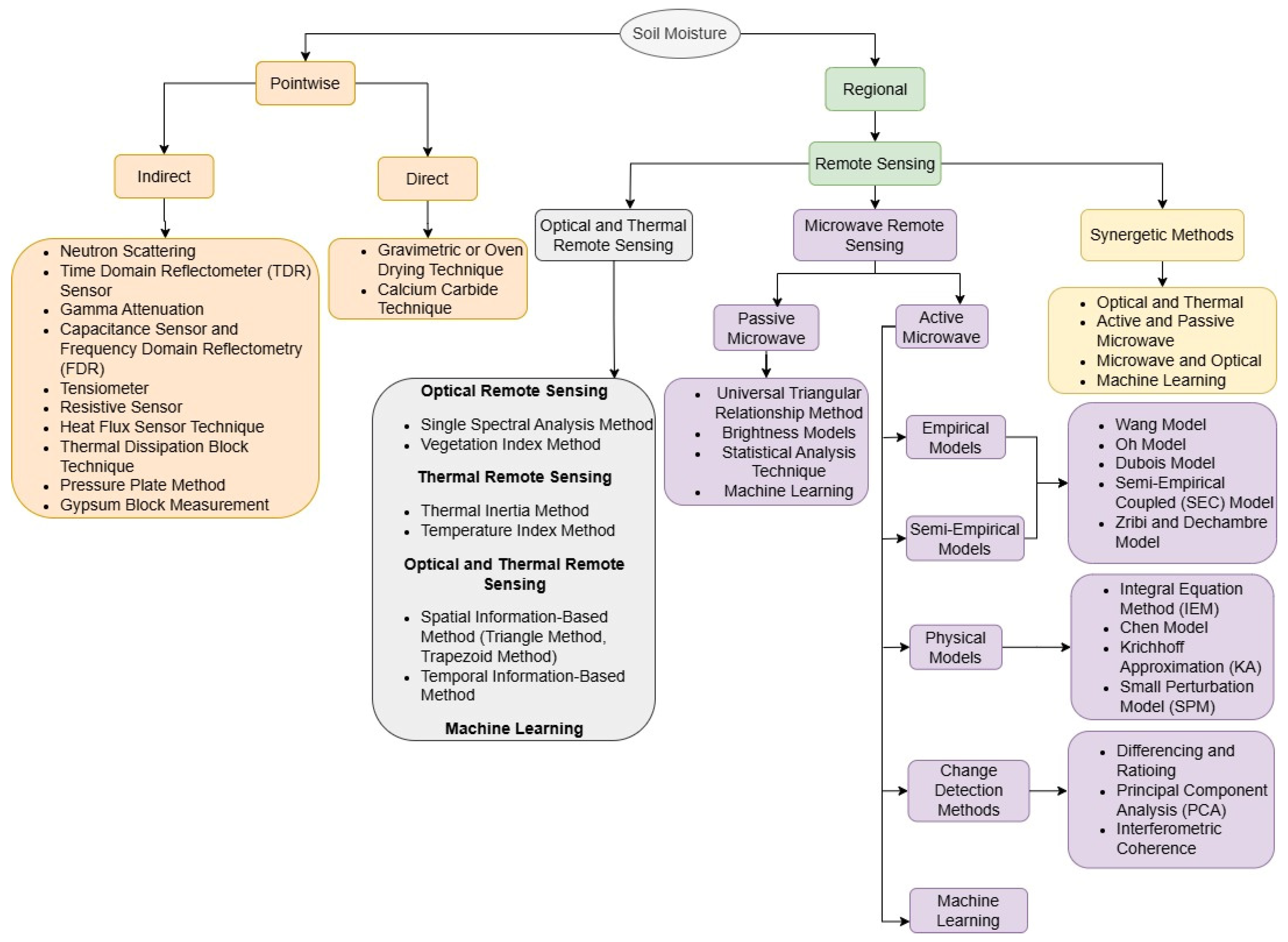
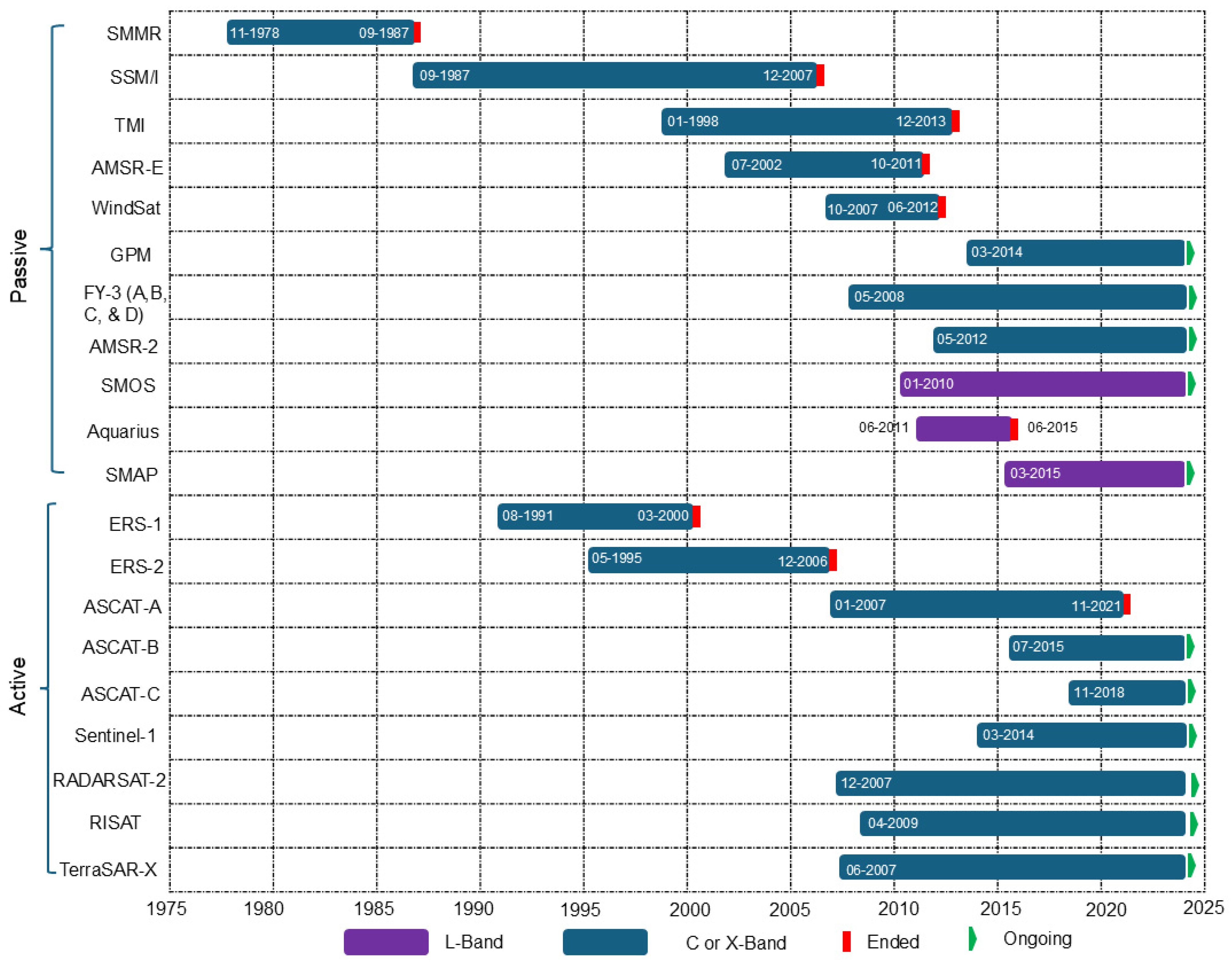
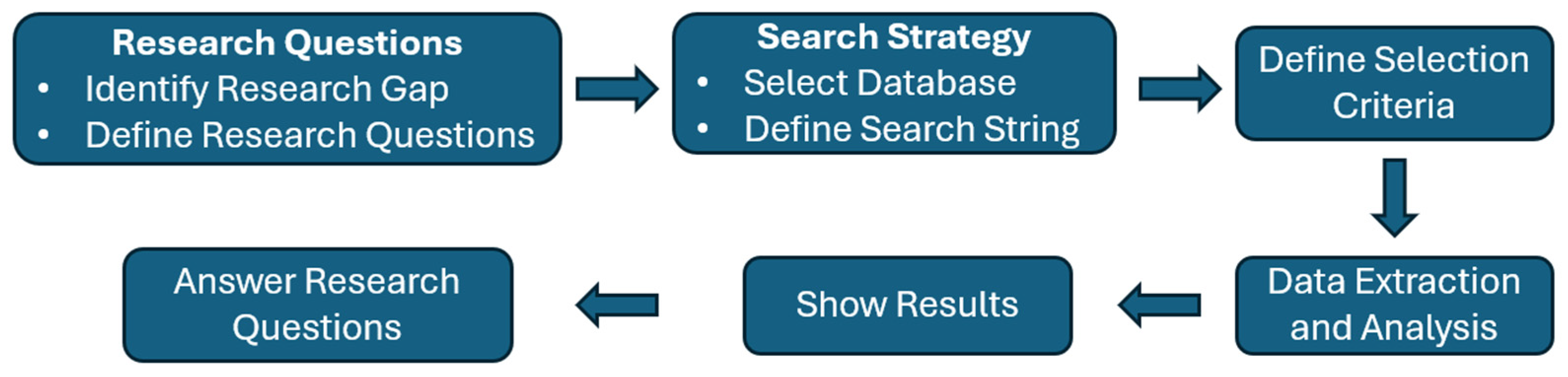

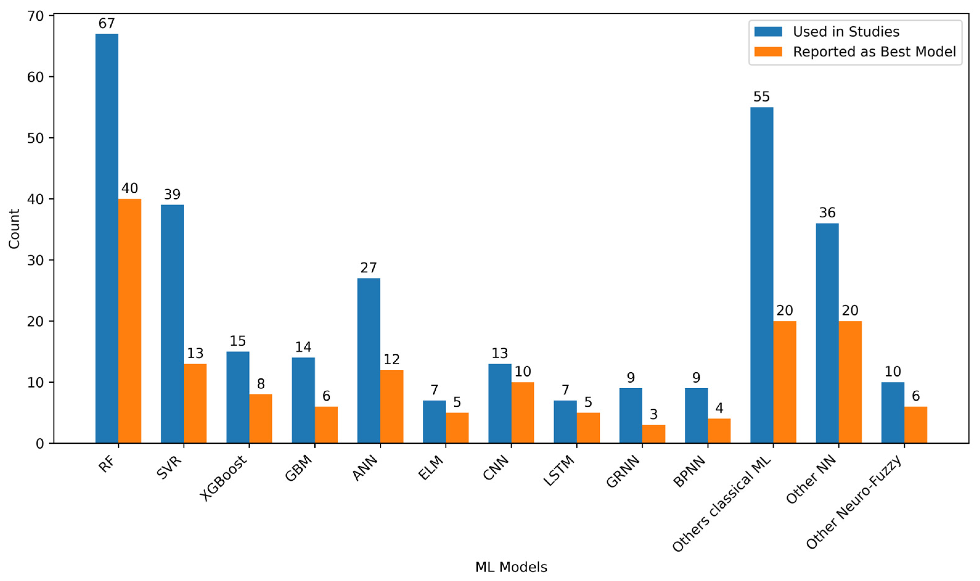
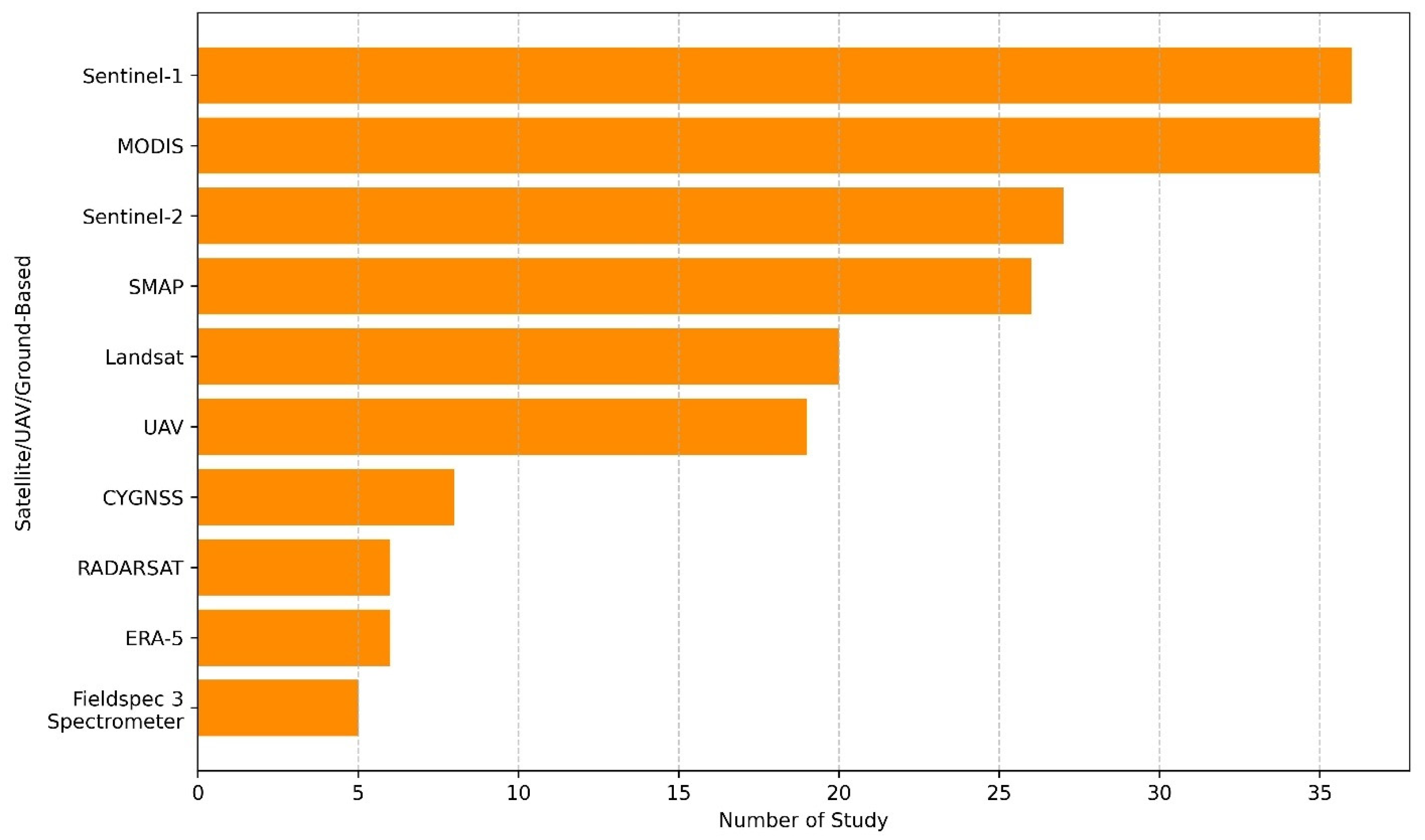
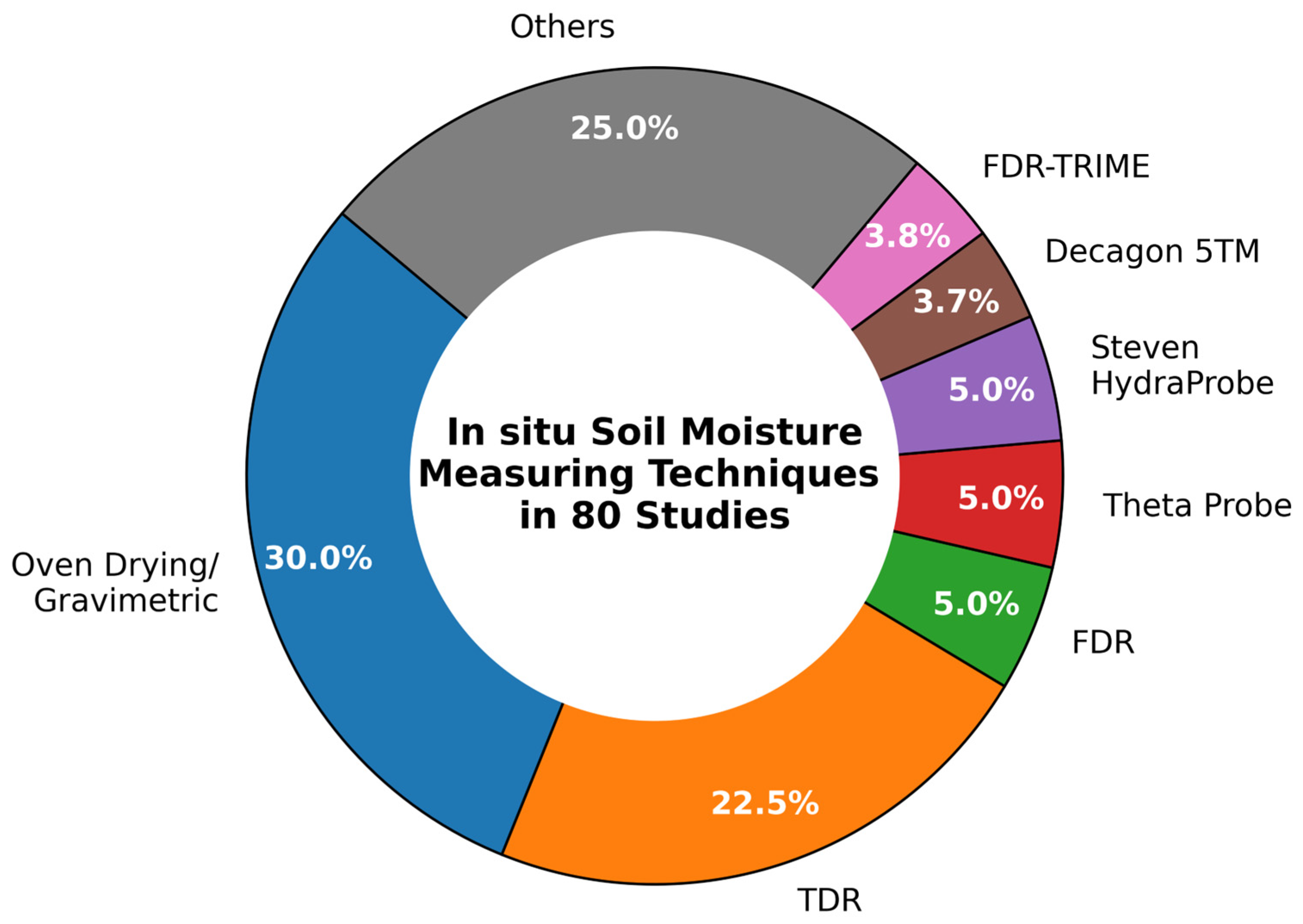
| Criterion Number | Exclusion Criteria |
|---|---|
| 1 | Publications not written in English |
| 2 | Study outside the scope of research questions (not related to soil moisture estimation using remote sensing and machine learning) |
| 3 | Publication is a book, e-book, poster, survey |
| 4 | Published before 2010 |
Disclaimer/Publisher’s Note: The statements, opinions and data contained in all publications are solely those of the individual author(s) and contributor(s) and not of MDPI and/or the editor(s). MDPI and/or the editor(s) disclaim responsibility for any injury to people or property resulting from any ideas, methods, instructions or products referred to in the content. |
© 2025 by the authors. Licensee MDPI, Basel, Switzerland. This article is an open access article distributed under the terms and conditions of the Creative Commons Attribution (CC BY) license (https://creativecommons.org/licenses/by/4.0/).
Share and Cite
Lamichhane, M.; Mehan, S.; Mankin, K.R. Soil Moisture Prediction Using Remote Sensing and Machine Learning Algorithms: A Review on Progress, Challenges, and Opportunities. Remote Sens. 2025, 17, 2397. https://doi.org/10.3390/rs17142397
Lamichhane M, Mehan S, Mankin KR. Soil Moisture Prediction Using Remote Sensing and Machine Learning Algorithms: A Review on Progress, Challenges, and Opportunities. Remote Sensing. 2025; 17(14):2397. https://doi.org/10.3390/rs17142397
Chicago/Turabian StyleLamichhane, Manoj, Sushant Mehan, and Kyle R. Mankin. 2025. "Soil Moisture Prediction Using Remote Sensing and Machine Learning Algorithms: A Review on Progress, Challenges, and Opportunities" Remote Sensing 17, no. 14: 2397. https://doi.org/10.3390/rs17142397
APA StyleLamichhane, M., Mehan, S., & Mankin, K. R. (2025). Soil Moisture Prediction Using Remote Sensing and Machine Learning Algorithms: A Review on Progress, Challenges, and Opportunities. Remote Sensing, 17(14), 2397. https://doi.org/10.3390/rs17142397