Study on the Impact of Urban Morphologies on Urban Canopy Heat Islands Based on Relocated Meteorological Stations


Abstract
1. Introduction
2. Data and Methodology
2.1. Data
2.1.1. SAT Data
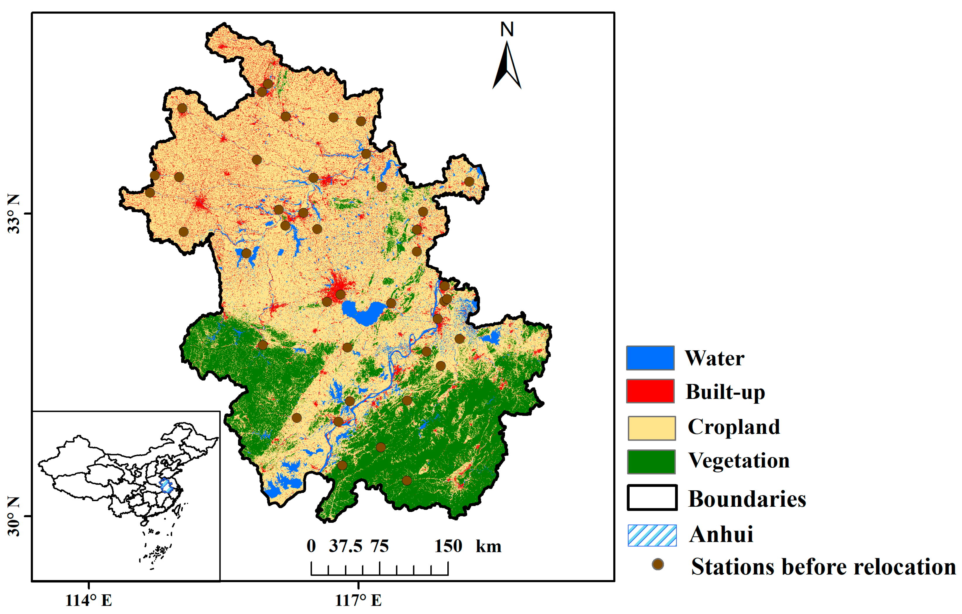
2.1.2. Land Cover Data
2.2. Methodology
2.2.1. Selection of Relocated Station Samples
- (1)
- Stations were relocated primarily due to significant deterioration of the detection environment, such as increased urbanization and industrial pollution. This relocation aimed to preserve the integrity and reliability of the meteorological data;
- (2)
- To minimize potential variations in climate conditions, the altitude differences between the original and new locations were strictly controlled to be less than 50 m. Additionally, the horizontal straight-line distance between the two locations did not exceed 20 km;
- (3)
- Terrain and landforms were carefully considered to ensure minimal significant differences between the original and new stations. Both locations were situated in similar geographical regions to maintain consistency in climatic characteristics;
- (4)
- To ensure comparability and continuity of the meteorological data, there were no changes in the type of observational instruments used at the new location.
2.2.2. Establishment of Urban Morphology Parameter Datasets
2.2.3. Fitting of the CUHII
3. Results
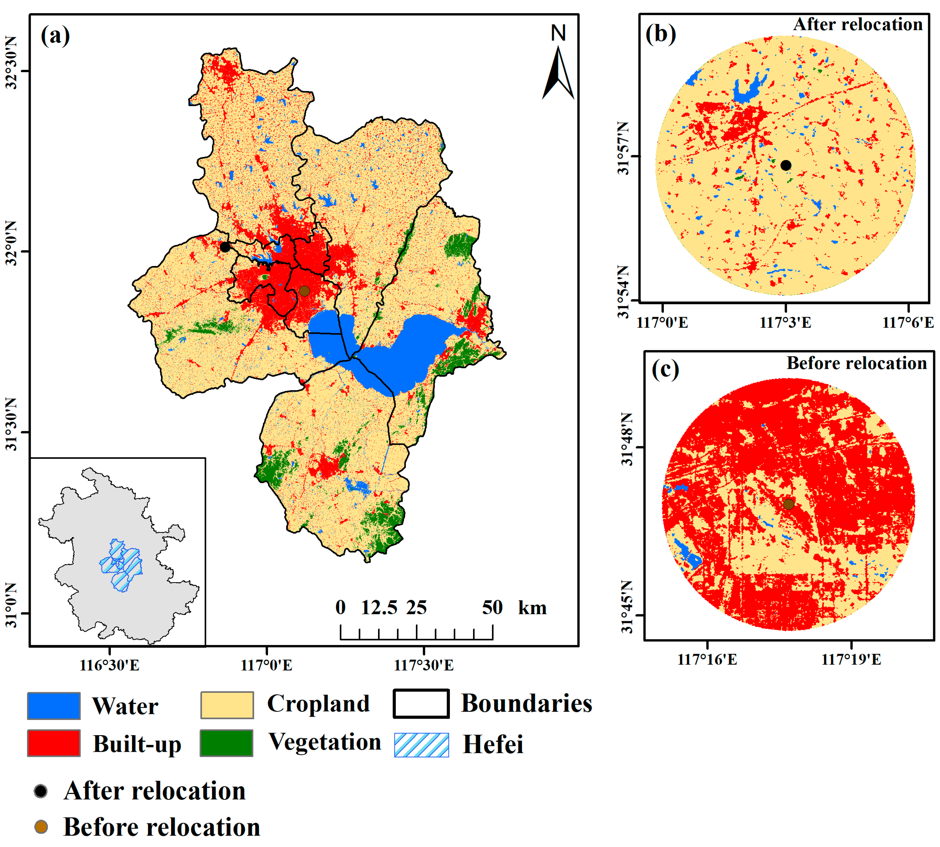
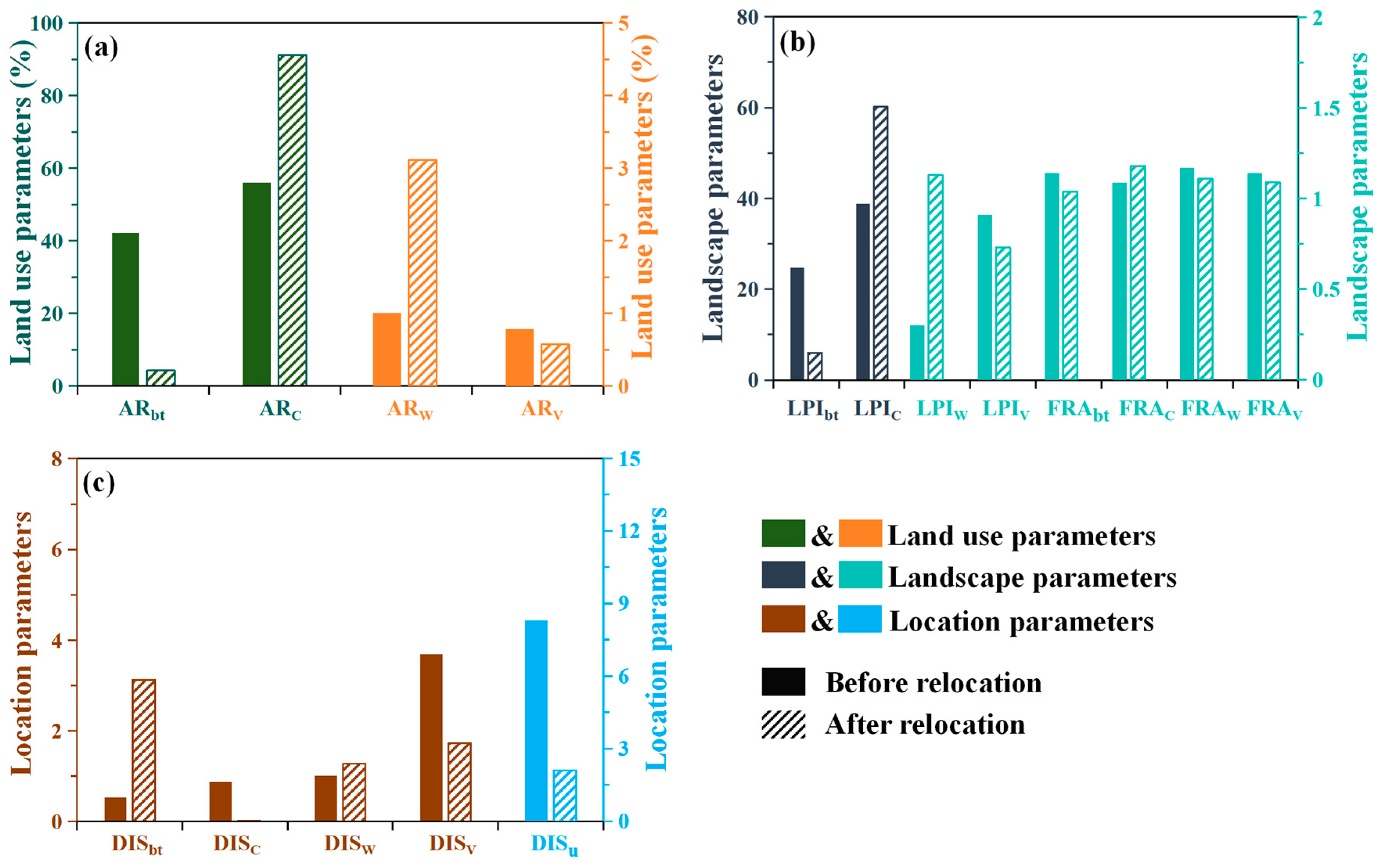
3.1. Comparison of Typical Station before and after Relocation
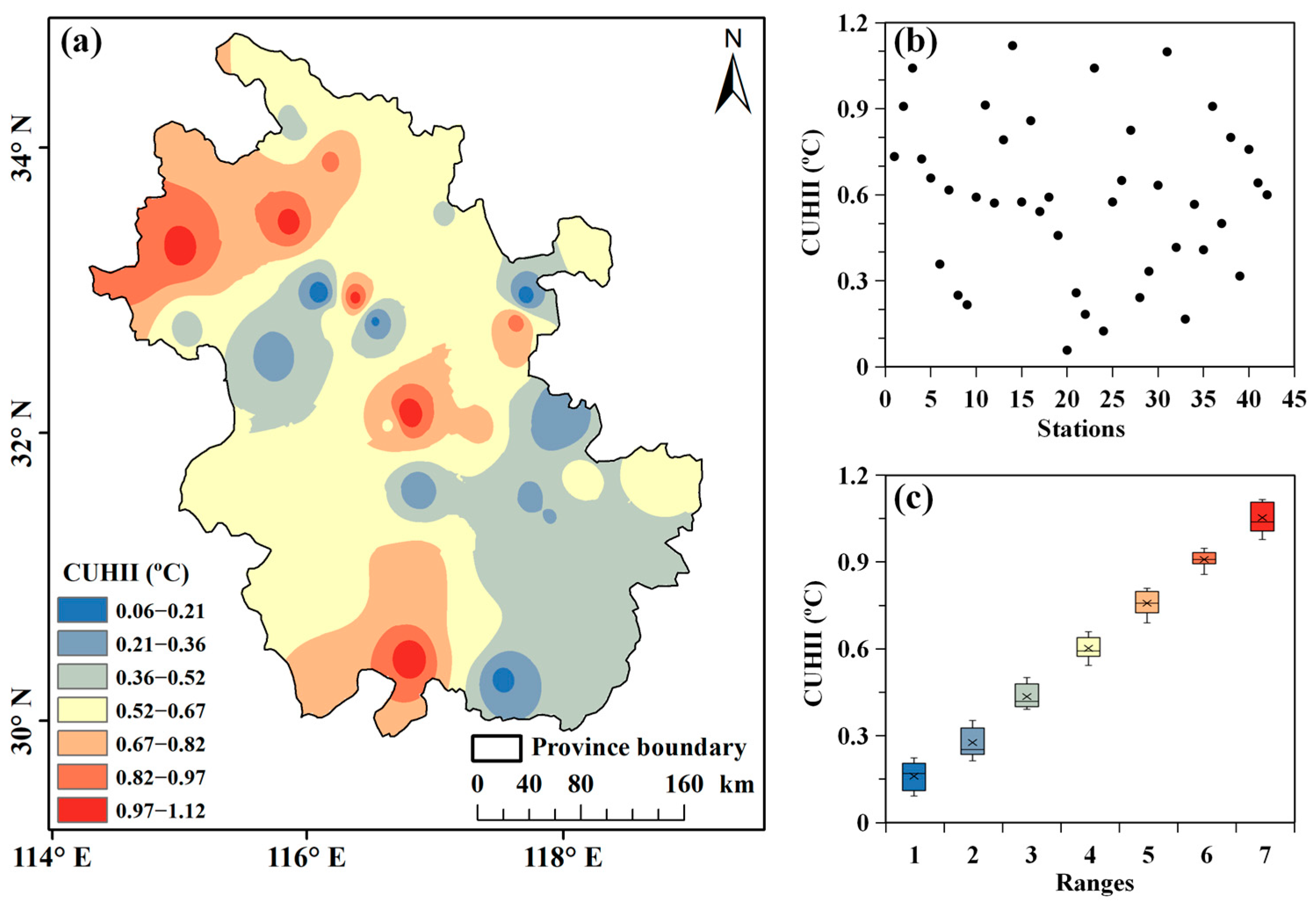
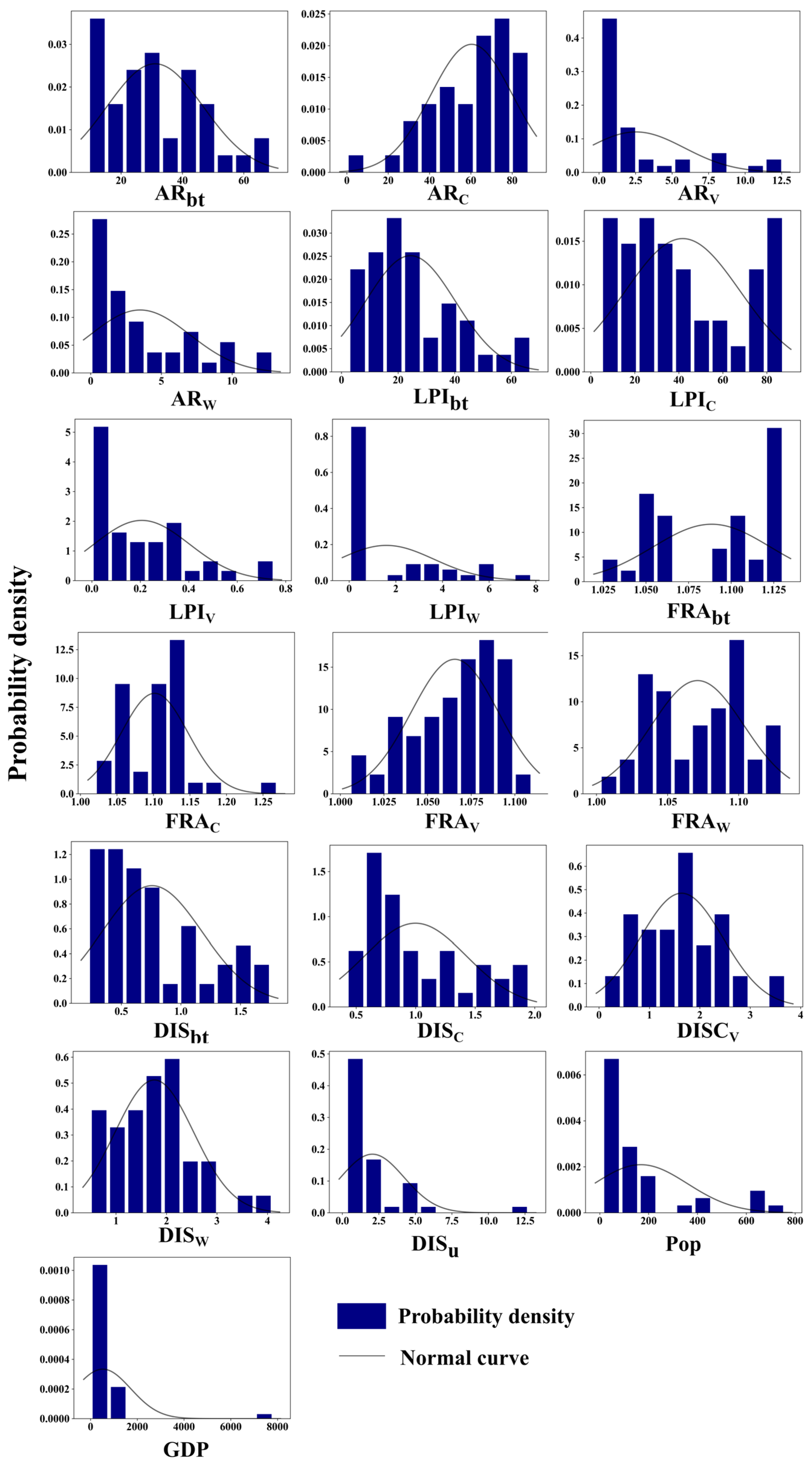
3.2. Characteristics of CUHI and Urban Morphologies in Relocation Station Samples
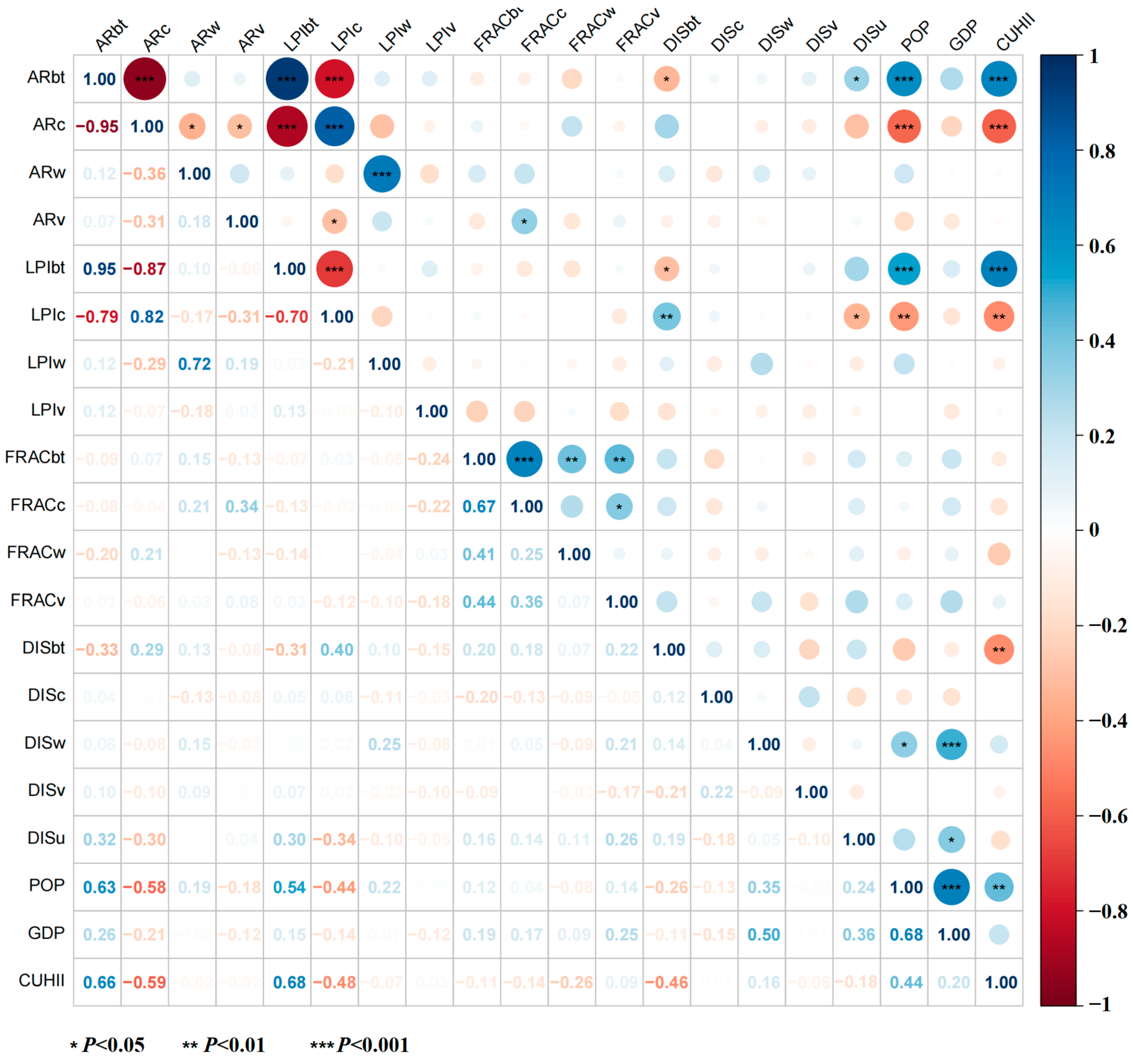
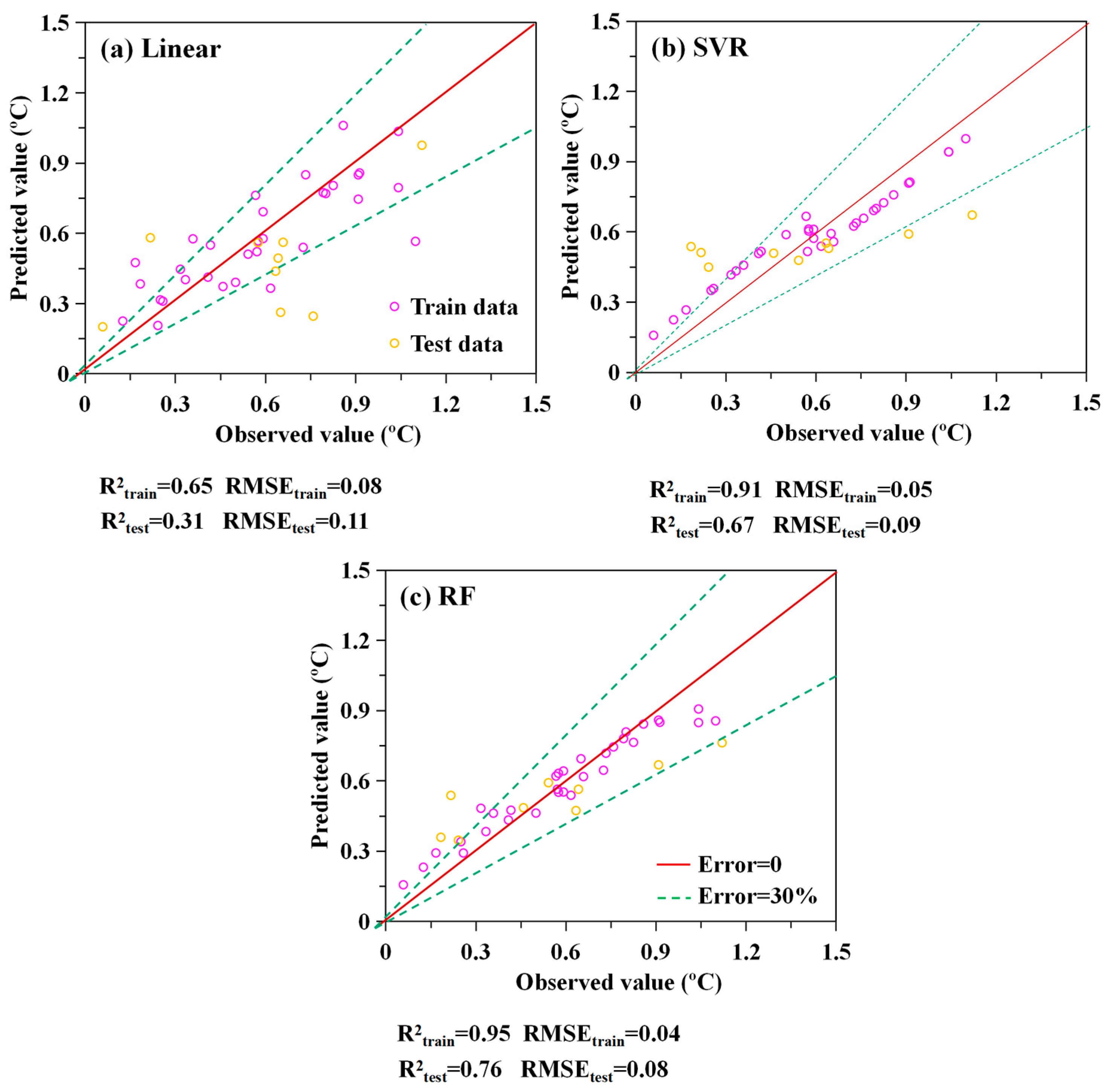
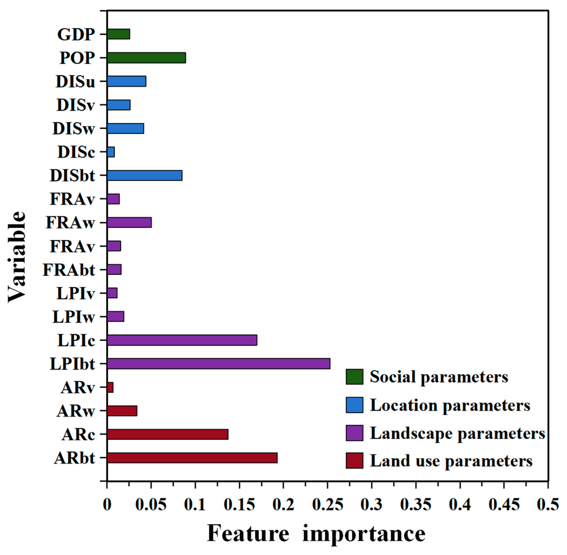
3.3. The Impact of Urban Morphologies on the CUHI
4. Discussion
5. Conclusions
Author Contributions
Funding
Institutional Review Board Statement
Informed Consent Statement
Data Availability Statement
Conflicts of Interest
Abbreviations
| Abbreviations | Full Names |
| UHI | Urban heat islands |
| CUHI | Canopy urban heat islands |
| CUHI | Canopy urban heat islands intensity |
| LCLU | Land cover/land use |
| SAT | Surface air temperature |
| YRD | Yangtze River Delta region |
| CLCD | China Land Cover Dataset |
| SVR | Support Vector Regression |
| RF | Random Forest |
| CV | Cross-validation |
| R2 | coefficient of determination |
| RMSE | root-mean-square error |
| ARbt | Ratio of built-up area |
| ARw | Ratio of water body area |
| ARc | Ratio of cropland area |
| ARv | Ratio of vegetation area |
| LPIbt | Largest patch index of built-up area |
| LPIw | Largest patch index of water body area |
| LPIc | Largest patch index of cropland area |
| LPIv | Largest patch index of vegetation area |
| DISbt | Distances between the stations and the built-up area |
| DISw | Distances between the stations and the water body area |
| DISc | Distances between the stations and the cropland area |
| DISv | Distances between the stations and the vegetation area |
| DISu | Distances between the stations and the urban center |
References
- Grimm, N.B.; Faeth, S.H.; Golubiewski, N.E.; Redman, C.L.; Wu, J.G.; Bai, X.M.; Briggs, J.M. Global change and the ecology of cities. Science 2008, 319, 756–760. [Google Scholar] [CrossRef] [Scilit] [PubMed]
- Wang, W.; Zhou, W.; Ng, E.Y.Y.; Xu, Y. Urban heat islands in Hong Kong: Statistical modeling and trend detection. Nat. Hazards 2016, 83, 885–907. [Google Scholar] [CrossRef] [Scilit]
- Yang, Y.; Wang, L.; Huang, Y.; Shi, C.; Shi, T. Impact of urbanization on meteorological observation and its environment representativeness: A case study of Shouxian national climate station. Meteorol. Sci. Technol. 2017, 45, 7–13. (In Chinese) [Google Scholar] [CrossRef]
- Kang, H.Q.; Zhu, B.; Zhu, T.; Gao, J.H.; Sun, J.L.; Su, J.F. Investigation of an urban heat island episode along Suzhou-Wuxi-Changzhou urban cluster. Trans. Atmos. Sci. 2014, 37, 432–440. (In Chinese) [Google Scholar] [CrossRef]
- Li, Y.; Sebastian, S.; Kropp, J.P.; Rybski, D. On the influence of density and morphology on the urban heat island intensity. Nat. Commun. 2020, 11, 2647. [Google Scholar] [CrossRef] [Scilit] [PubMed]
- Li, Y.; Yang, T.; Zhao, G.; Ma, C.; Yan, Y.; Xu, Y.; Wang, L.; Wang, L. A systematic review of studies involving canopy layer urban heat island: Monitoring and associated factors. Ecol. Indic. 2024, 158, 111424. [Google Scholar] [CrossRef] [Scilit]
- Yang, Y.; Guo, M.; Ren, G.; Liu, S.; Zong, L.; Zhang, Y.; Zheng, Z.; Miao, Y.; Zhang, Y. Modulation of wintertime canopy urban heat island (CUHI) intensity in Beijing by synoptic weather pattern in planetary boundary layer. J. Geophys. Res. Atmos. 2022, 127, e2021JD035988. [Google Scholar] [CrossRef] [Scilit]
- Chen, S.; Yang, Y.; Deng, F.; Zhang, Y.; Liu, D.; Liu, C.; Gao, Z. A high-resolution monitoring approach of canopy urban heat island using a random forest model and multi-platform observations. Atmos. Meas. Tech. 2022, 15, 735–756. [Google Scholar] [CrossRef] [Scilit]
- Yang, Y.; Guo, M.; Wang, L.; Zong, L.; Liu, D.; Zhang, W.; Guo, Y. Unevenly spatiotemporal distribution of urban excess warming in coastal Shanghai megacity, China: Roles of geophysical environment, ventilation and sea breezes. Build. Environ. 2023, 235, 110180. [Google Scholar] [CrossRef] [Scilit]
- Shawky, M.; Ahmed, M.R.; Ghaderpour, E.; Gupta, A.; Achari, G.; Dewan, A.; Hassan, Q.K. Remote sensing-derived land surface temperature trends over South Asia. Ecol. Inform. 2023, 74, 101969. [Google Scholar] [CrossRef] [Scilit]
- Gubler, S.; Hunziker, S.; Begert, M.; Croci-Maspoli, M.; Konzelmann, T.; Brönnimann, S.; Schwierz, C.; Oria, C.; Rosas, G. The influence of station density on climate data homogenization. Int. J. Climatol. 2017, 37, 4670–4683. [Google Scholar] [CrossRef] [Scilit]
- Rahaman, K.R.; Hassan, Q.K.; Chowdhury, E.H. Quantification of local warming trend: A remote sensing-based approach. PLoS ONE 2017, 12, e0169423. [Google Scholar] [CrossRef] [Scilit] [PubMed]
- Rogers, C.D.W.; Gallant, A.J.E.; Tapper, N.J. Is the urban heat island exacerbated during heatwaves in southern Australian cities? Theor. Appl. Climatol. 2019, 137, 441–457. [Google Scholar] [CrossRef] [Scilit]
- Scott, A.A.; Waugh, D.W.; Zaitchik, B.F. Reduced urban heat island intensity under warmer conditions. Environ. Res. Lett. 2018, 13, 064003. [Google Scholar] [CrossRef] [Scilit] [PubMed]
- Liu, Y. A Preliminary Analysis of the Influence of Urbanization on Precipitation Change Trend in North China. Master’s Thesis, Lanzhou University, Lanzhou, China, 2006. (In Chinese) [Google Scholar]
- Ren, G.; Zhang, A.; Chu, Z.; Zhou, J.; Ren, Y.; Zhou, Y. Principles and procedures for selecting reference surface air temperature stations in China. Meteorol. Sci. Technol. 2010, 38, 78–85. [Google Scholar] [CrossRef]
- Sun, S.; Zhou, D.; Chen, H.; Li, J.; Ren, Y.; Liao, H.; Liu, Y. Decreases in the urban heat island effect during the Coronavirus Disease 2019 (COVID-19) lockdown in Wuhan, China: Observational evidence. Int. J. Climatol. 2022, 42, 8792–8803. [Google Scholar] [CrossRef] [Scilit]
- Zhou, D.; Sun, S.; Li, Y.; Zhang, L.; Huang, L. A multi-perspective study of atmospheric urban heat island effect in China based on national meteorological observations: Facts and uncertainties. Sci. Total Environ. 2023, 854, 158638. [Google Scholar] [CrossRef] [Scilit] [PubMed]
- Yang, P.; Ren, G.; Hou, W. Impact of daytime precipitation duration on urban heat island intensity over Beijing city. Urban Clim. 2019, 28, 100463. [Google Scholar] [CrossRef] [Scilit]
- Zhang, Y. Assessment and Correction of Urban Bias in Surface Air Temperature Series of Eastern China over Time Period 1913–2012. Master’s Thesis, China Academy of Meteorological Sciences, Beijing, China, 2014. (In Chinese) [Google Scholar]
- Wen, K.; Ren, G.; Li, J.; Zhang, A.; Ren, Y.; Sun, X.; Zhou, Y. Recent surface air temperature change over mainland China based on an urbanization-bias adjusted dataset. J. Clim. 2019, 32, 2691–2705. [Google Scholar] [CrossRef] [Scilit]
- Yang, Y.; Wu, B.; Shi, C.; Zhang, J.; Li, Y.; Tang, W.; Wen, H.; Zhang, H.; Shi, T. Impacts of urbanization and station-relocation on surface air temperature series in Anhui Province, China. Pure Appl. Geophys. 2013, 170, 1969–1984. [Google Scholar] [CrossRef] [Scilit]
- Fenner, D.; Meier, F.; Bechtel, B.; Otto, M.; Scherer, D. Intra and inter ‘local climate zone’ variability of air temperature as observed by crowdsourced citizen weather stations in Berlin, Germany. Meteorol. Z. 2017, 26, 525–547. [Google Scholar] [CrossRef] [Scilit]
- Dang, B.; Liu, Y.; Lyu, H.; Zhou, X.; Du, W.; Xuan, C.; Xing, P.; Yang, R.; Xiong, F. Assessment of urban climate environment and configuration of ventilation corridor: A refined study in Xi’an. J. Meteorol. Res. 2022, 36, 914–930. [Google Scholar] [CrossRef] [Scilit]
- Oke, T.R. The energetic basis of the urban heat island. Q. J. R. Meteorol. Soc. 1982, 108, 1–24. [Google Scholar] [CrossRef] [Scilit]
- Afnfield, A.J. Two decades of urban climate research: A review of turbulence, exchanges of energy and water, and the urban heat island. Int. J. Climatol. 2003, 23, 1–26. [Google Scholar] [CrossRef] [Scilit]
- Fujibe, F. Long-term surface wind changes in the Tokyo metropolitan area in the afternoon of sunny days in the warm season. J. Meteorol. Soc. Jpn. Ser. II 2003, 81, 141–149. [Google Scholar] [CrossRef] [Scilit]
- Zong, L.; Liu, S.; Yang, Y.; Ren, G.; Li, Y. Synergistic Influence of Local Climate Zones and Wind Speeds on the Urban Heat Island and Heat Waves in the Megacity of Beijing, China. Front. Earth Sci. 2021, 9, 673786. [Google Scholar] [CrossRef] [Scilit]
- Li, Y.; Ye, H.; Sun, X.; Zheng, J.; Meng, D. Coupling analysis of the thermal landscape and environmental carrying capacity of urban expansion in Beijing (China) over the past 35 years. Sustainability 2021, 13, 584. [Google Scholar] [CrossRef] [Scilit]
- Shi, T.; Huang, Y.; Wang, H.; Shi, C.; Yang, Y. Influence of Urbanization on the Thermal Environment of Meteorological Stations: Satellite-observational Evidence. Adv. Clim. Chang. Res. 2015, 6, 7–15. [Google Scholar] [CrossRef] [Scilit]
- Li, Y.; Shi, T.; Yang, Y.; Wu, B.; Wang, L.; Shi, C.; Guo, J.; Ji, C.; Wen, H. Satellite-based Investigation and Evaluation of the Observational Environment of Meteorological Stations in Anhui Province. Pure Appl. Geophys. 2015, 172, 1735–1749. [Google Scholar] [CrossRef] [Scilit]
- Wang, C.; Wei, X.; Yan, J.; Jin, L. Grade evaluation of detection environment of meteorological stations in Beijing. J. Appl. Meteor. Sci. 2019, 30, 117–128. [Google Scholar] [CrossRef]
- Comprehensive Observation Department of China Meteorological Administration. Basic Information Change Table of National Surface Meteorological Observation Station; China Meterological Administration: Beijing, China, 2015. (In Chinese)
- Meteorological Observation Centre of CMA. Investigation and Evaluation Report on Detection Environment of National Surface Meteorological Observation Station and Aerological Station; China Meterological Administration: Beijing, China, 2013. (In Chinese)
- Ana, C.L.M.P.; Payésa, T.; Rozely, F.D.S. The conservation success over time: Evaluating the land use and cover change in a protected area under a long re-categorization process. Land Use Policy 2013, 30, 177–185. [Google Scholar] [CrossRef] [Scilit]
- Yang, J.; Huang, X. The 30 m annual land cover dataset and its dynamics in China from 1990 to 2019. Earth Syst. Sci. Data 2021, 13, 3907–3925. [Google Scholar] [CrossRef] [Scilit]
- Cai, X.H. Footprint analysis in micrometeorology and its extended applications. Chin. J. Atmos. Sci. 2008, 32, 123–132. (In Chinese) [Google Scholar] [CrossRef] [Scilit]
- Yang, Y.; Zhang, M.; Li, Q.; Chen, B.; Luo, M. Modulations of surface thermal environment and agricultural activity on intraseasonal variations of summer diurnal temperature range in the Yangtze River Delta of China. Sci. Total Environ. 2020, 736, 139445. [Google Scholar] [CrossRef] [Scilit] [PubMed]
- Li, J.; Song, C.; Cao, L.; Zhu, F.; Meng, X.; Wu, J. Impacts of landscape structure on surface urban heat islands: A case study of Shanghai, China. Remote Sens. Environ. 2011, 115, 3249–3263. [Google Scholar] [CrossRef] [Scilit]
- Ren, G.; Li, J.; Ren, Y.; Chu, Z.; Zhang, A.; Zhou, Y.; Zhang, L.; Zhang, Y.; Bian, T. An integrated procedure to determine a reference station network for evaluating and adjusting urban bias in surface air temperature data. J. Appl. Meteorol. Climatol. 2015, 54, 1248–1266. (In Chinese) [Google Scholar] [CrossRef] [Scilit]
- Wu, J. Landscape Ecology, Pattern, Process, Scale and Grade; Higher Education Press: Beijing, China, 2000; pp. 107–115. [Google Scholar]
- Liu, J.; Kuang, W.; Zhang, Z.; Xu, L.; Qin, Y.; Ning, J. Spatiotemporal characteristics, patterns and causes of land use changes in China since the late 1980s. Acta Geogr. Sin. 2014, 69, 3–14. (In Chinese) [Google Scholar] [CrossRef] [Scilit]
- Li, Q. Statistical modeling experiment of land precipitation variations since the start of the 20th century with external forcing factors. Chin. Sci. Bull. 2020, 65, 2266–2278. [Google Scholar] [CrossRef] [Scilit]
- Smola, A.J.; Schölkopf, B. A tutorial on support vector regression. Stat. Comput. 2004, 14, 199–222. [Google Scholar] [CrossRef] [Scilit]
- Breiman, L. Random Forests. Mach. Learn. 2001, 45, 5–32. [Google Scholar] [CrossRef] [Scilit]
- Hastie, T.; Tibshirani, R.; Friedman, J. The Elements of Statistical Learning: Data Mining, Inference, and Prediction, 2nd ed.; Springer Science + Business Media, LLC: New York, NY, USA, 2009. [Google Scholar]
- Zeng, Z.; Wang, Z.; Gui, K.; Yan, X.; Gao, M.; Luo, M.; Geng, H.; Liao, T.; Li, X.; An, J. Daily global solar radiation in China estimated from high-density meteorological observations: A random forest model framework. Earth Space Sci. 2020, 7, e2019EA001058. [Google Scholar] [CrossRef] [Scilit]
- Li, S.; Shan, J. Adaptive Geometric Interval Classifier. SPRS Int. J. Geo-Inf. 2022, 11, 430. [Google Scholar] [CrossRef] [Scilit]
- Zeng, Y.; Zhang, S.; Zhang, H.; Huang, W.; Liu, H. Study on urban heat island effects and its associated surface indicators. Remote Sens. Technol. Appl. 2010, 25, 1–7. [Google Scholar] [CrossRef] [Scilit]
- Zhao, L.; Oppenheimer, M.; Zhu, Q.; Liu, X. Interactions between urban heat islands and heat waves. Environ. Res. Lett. 2018, 13, 034003. [Google Scholar] [CrossRef] [Scilit]
- Knight, S.; Smith, C.; Roberts, M. Mapping Manchester’s urban heat island. Weather 2010, 65, 188–193. [Google Scholar] [CrossRef] [Scilit]
- Miao, S.; Dou, J.; Chen, F.; Li, J.; Li, A. Analysis of observations on the urban surface energy balance in Beijing. Sci. China Earth Sci. 2012, 55, 1881–1890. [Google Scholar] [CrossRef] [Scilit]
- Estoque, R.C.; Murayama, Y.; Myint, S.W. Effects of landscape composition and pattern on land surface temperature: An urban heat island study in the megacities of Southeast Asia. Sci. Total Environ. 2017, 577, 349–359. [Google Scholar] [CrossRef] [Scilit]
- Givoni, B. Urban design for hot humid region. Renew. Energy 1994, 5, 1047–1053. [Google Scholar] [CrossRef] [Scilit]
- Shashua-Bar, L.; Hoffman, M.E. Vegetation as climatic component in the design of an urban street-an empirical model for predicting the cooling effect of urban green areas with trees. Energy Build. 2000, 31, 221–235. [Google Scholar] [CrossRef] [Scilit]
- Chun, B.; Guldmann, J.M. Spatial statistical analysis and simulation of the urban heat island in high-density central cities. Landsc. Urban Plan. 2014, 125, 76–88. [Google Scholar] [CrossRef] [Scilit]
- Zheng, Z.; Zhou, W.; Yan, J.; Qian, Y.; Wang, J.; Li, W. The higher, the cooler? Effects of building height on land surface temperatures in residential areas of Beijing. Phys. Chem. Earth 2019, 110, 149–156. [Google Scholar] [CrossRef] [Scilit]
- Guo, A.; He, T.; Yue, W.; Xiao, W.; Yang, Y.; Zhang, M.; Li, M. Contribution of urban trees in reducing land surface temperature: Evidence from China’s major cities. Int. J. Appl. Earth Obs. Geoinf. 2023, 125, 103570. [Google Scholar] [CrossRef] [Scilit]
- Zhou, X.; Okaze, T.; Ren, C.; Cai, M.; Mochida, A. Evaluation of urban heat islands using local climate zones and the influence of sea-land breeze. Sustain. Cities Soc. 2020, 55, 102060. [Google Scholar] [CrossRef] [Scilit]
- Yin, C.; Wang, T.; Shi, C.; Wei, W. Analysis on wind characteristics at typical sites over Chaohu Lake basin. Trans. Atmos. Sci. 2012, 35, 249–256. (In Chinese) [Google Scholar] [CrossRef]
- Wanlong, C.; Jiang, C. A numerical simulation on lake-land breeze of Qinghai Lake. J. Lake Sci. 1995, 7, 289–296. (In Chinese) [Google Scholar] [CrossRef] [Scilit]
- Ren, X.; Wang, Y.; Zhang, Z.; Yang, Y.; Chen, H.U. Simulation studies for Lake Taihu effect on surrounding cities thermal environment. Acta Meteorol. Sin. 2017, 75, 645–660. (In Chinese) [Google Scholar] [CrossRef]


Disclaimer/Publisher’s Note: The statements, opinions and data contained in all publications are solely those of the individual author(s) and contributor(s) and not of MDPI and/or the editor(s). MDPI and/or the editor(s) disclaim responsibility for any injury to people or property resulting from any ideas, methods, instructions or products referred to in the content. |
© 2024 by the authors. Licensee MDPI, Basel, Switzerland. This article is an open access article distributed under the terms and conditions of the Creative Commons Attribution (CC BY) license (https://creativecommons.org/licenses/by/4.0/).
Share and Cite
Shi, T.; Yang, Y.; Qi, P. Study on the Impact of Urban Morphologies on Urban Canopy Heat Islands Based on Relocated Meteorological Stations. Remote Sens. 2024, 16, 1500. https://doi.org/10.3390/rs16091500
Shi T, Yang Y, Qi P. Study on the Impact of Urban Morphologies on Urban Canopy Heat Islands Based on Relocated Meteorological Stations. Remote Sensing. 2024; 16(9):1500. https://doi.org/10.3390/rs16091500
Chicago/Turabian StyleShi, Tao, Yuanjian Yang, and Ping Qi. 2024. "Study on the Impact of Urban Morphologies on Urban Canopy Heat Islands Based on Relocated Meteorological Stations" Remote Sensing 16, no. 9: 1500. https://doi.org/10.3390/rs16091500
APA StyleShi, T., Yang, Y., & Qi, P. (2024). Study on the Impact of Urban Morphologies on Urban Canopy Heat Islands Based on Relocated Meteorological Stations. Remote Sensing, 16(9), 1500. https://doi.org/10.3390/rs16091500