Geotechnologies in Biophysical Analysis through the Applicability of the UAV and Sentinel-2A/MSI in Irrigated Area of Common Beans: Accuracy and Spatial Dynamics
Abstract
1. Introduction
2. Materials and Methods
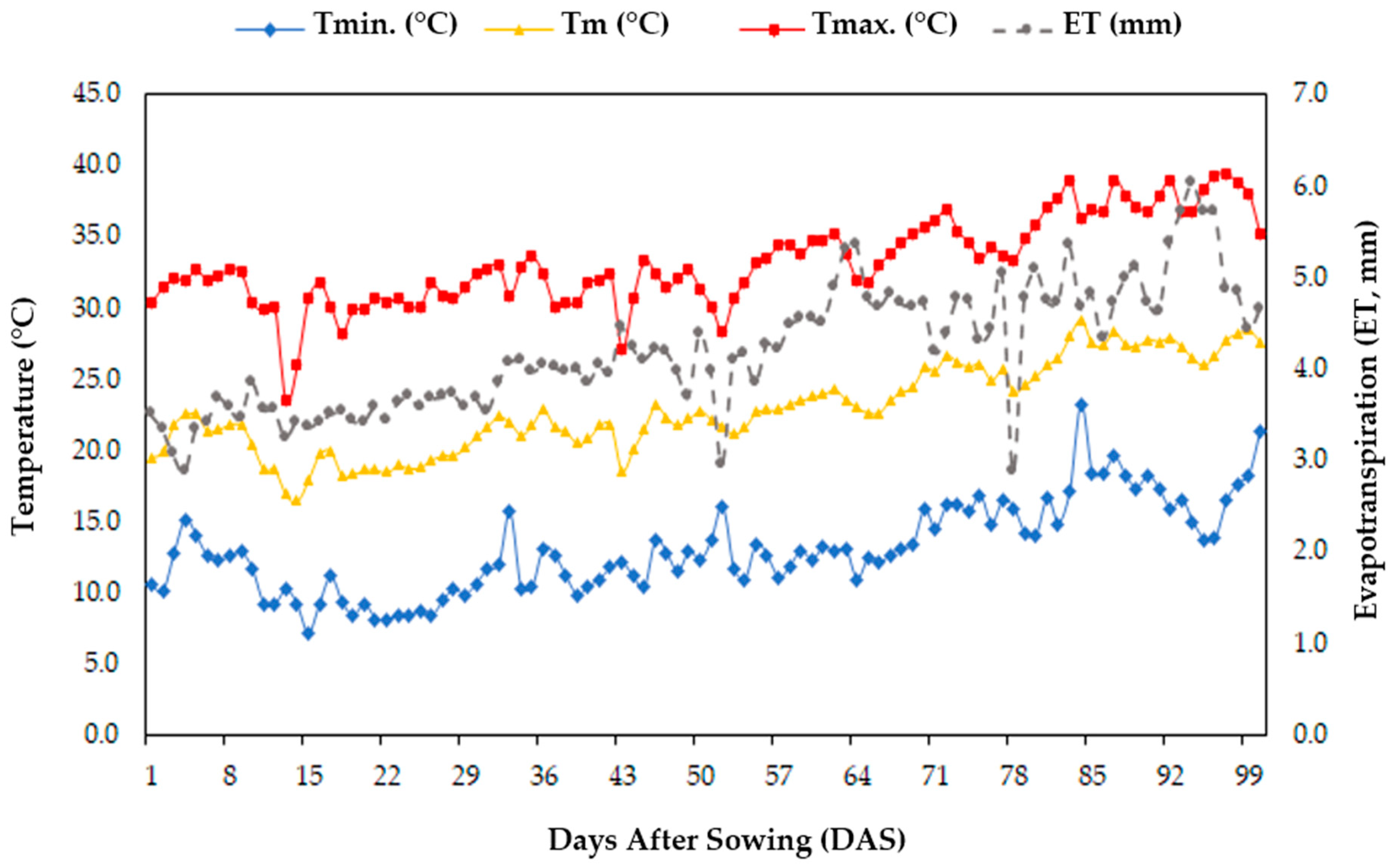
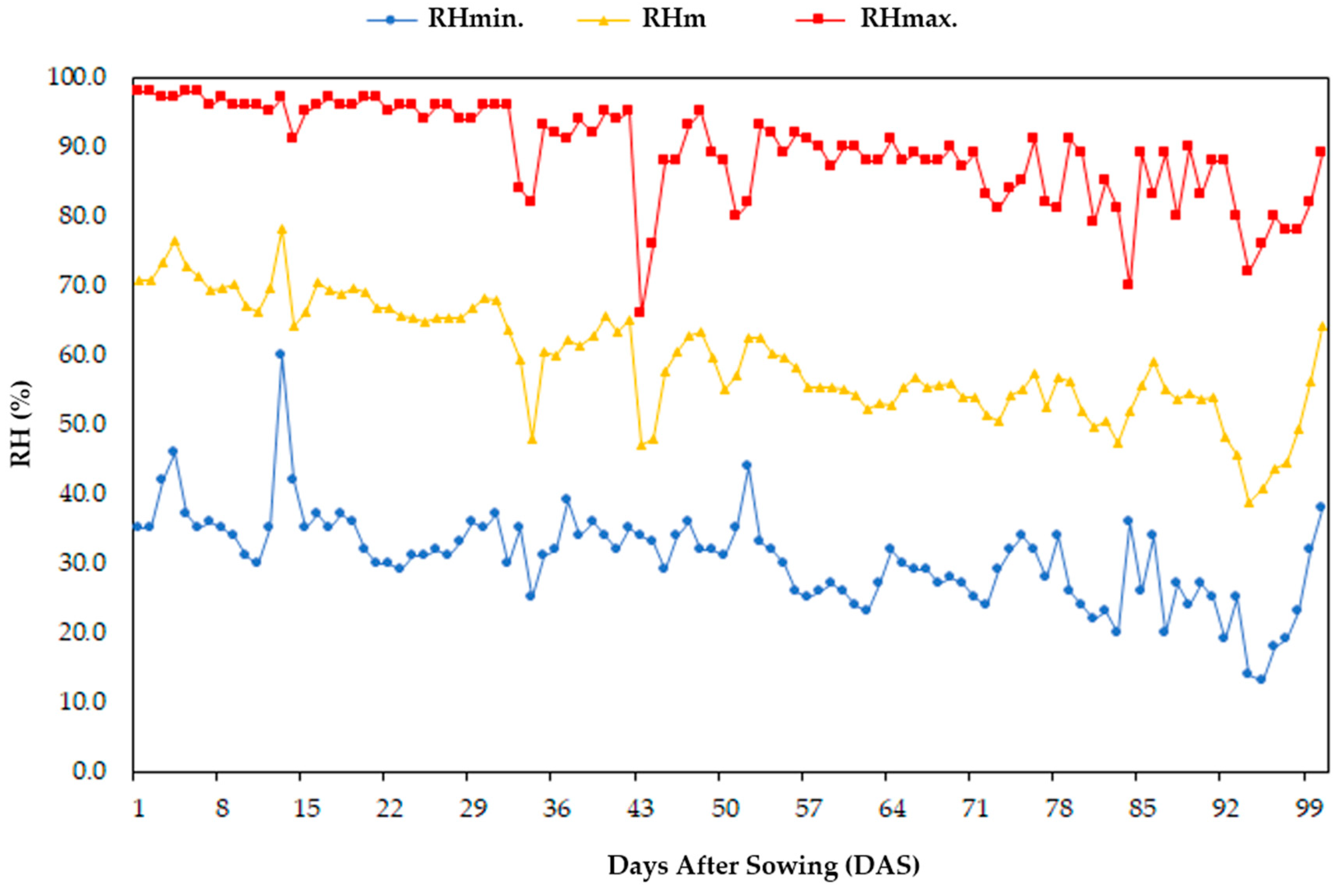
2.1. Experimental Site
2.2. Field Characteristics Analyzed
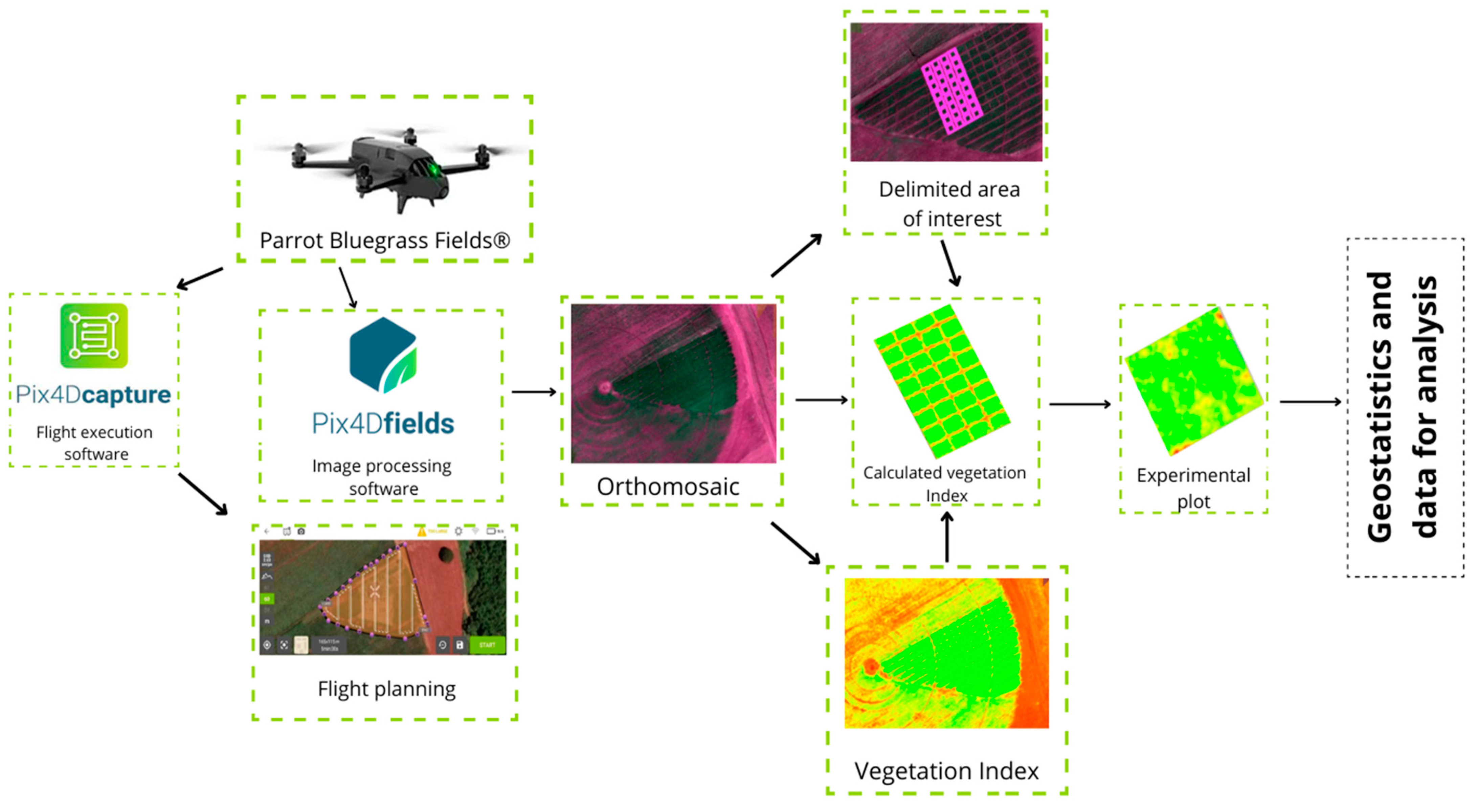
2.3. Image Acquisition and Digital Processing Analytics (from UAV)
2.4. Biophysical Indices (from UAV)
2.5. Orbital Data of Satellite (from Sentinel-2A/MSI)
Biophysical Indices (from Sentinel-2A/MSI Satellite)
2.6. Statistical Analysis
2.7. Multivariate Statistical Analysis
3. Results
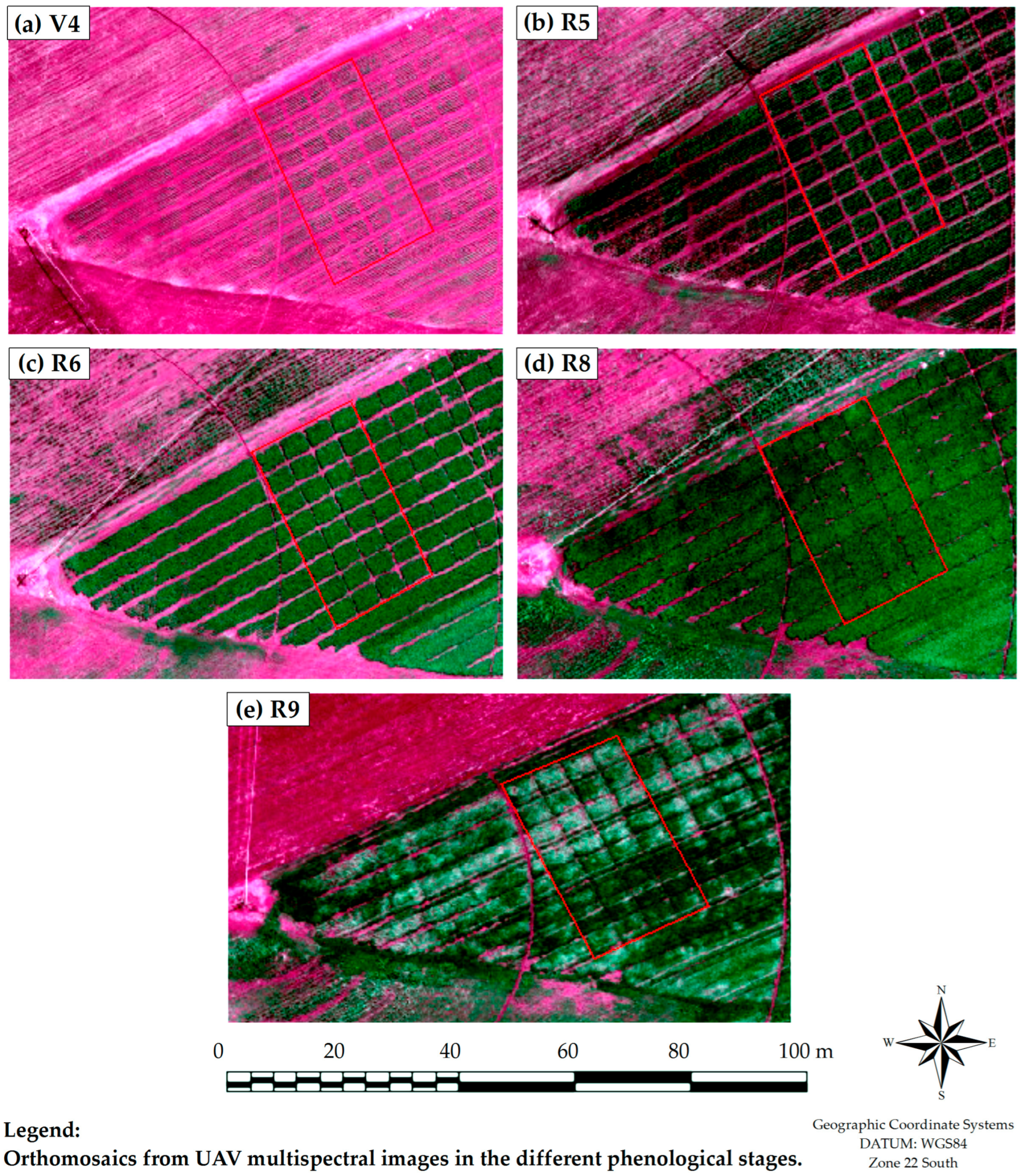
3.1. Spectral Response UAV to Treatments
3.2. Prediction of Productive Components
3.3. Prediction of Chlorophyll Content
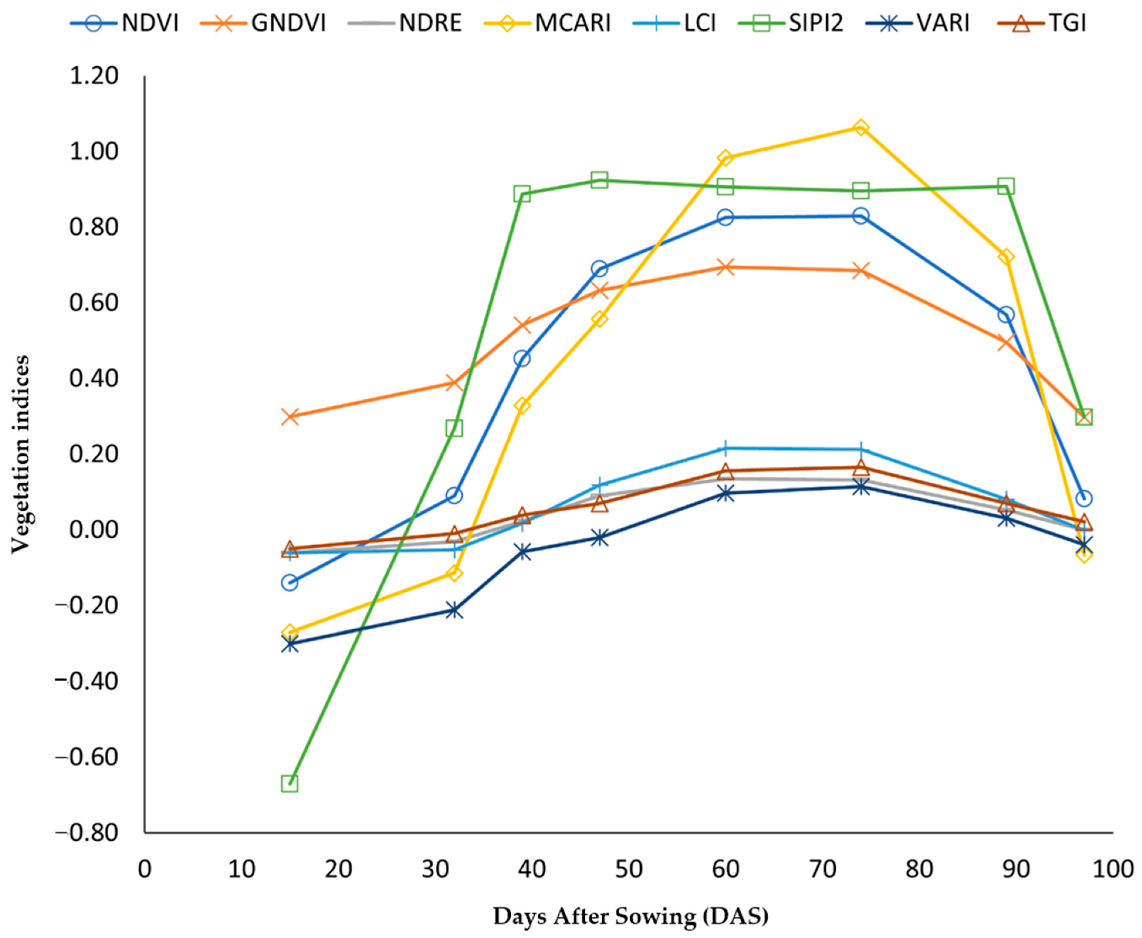
3.4. Temporal Variability of Vegetation Indices (IVs)
3.5. Satellite Data Analysis (Sentinel-2A/MSI)
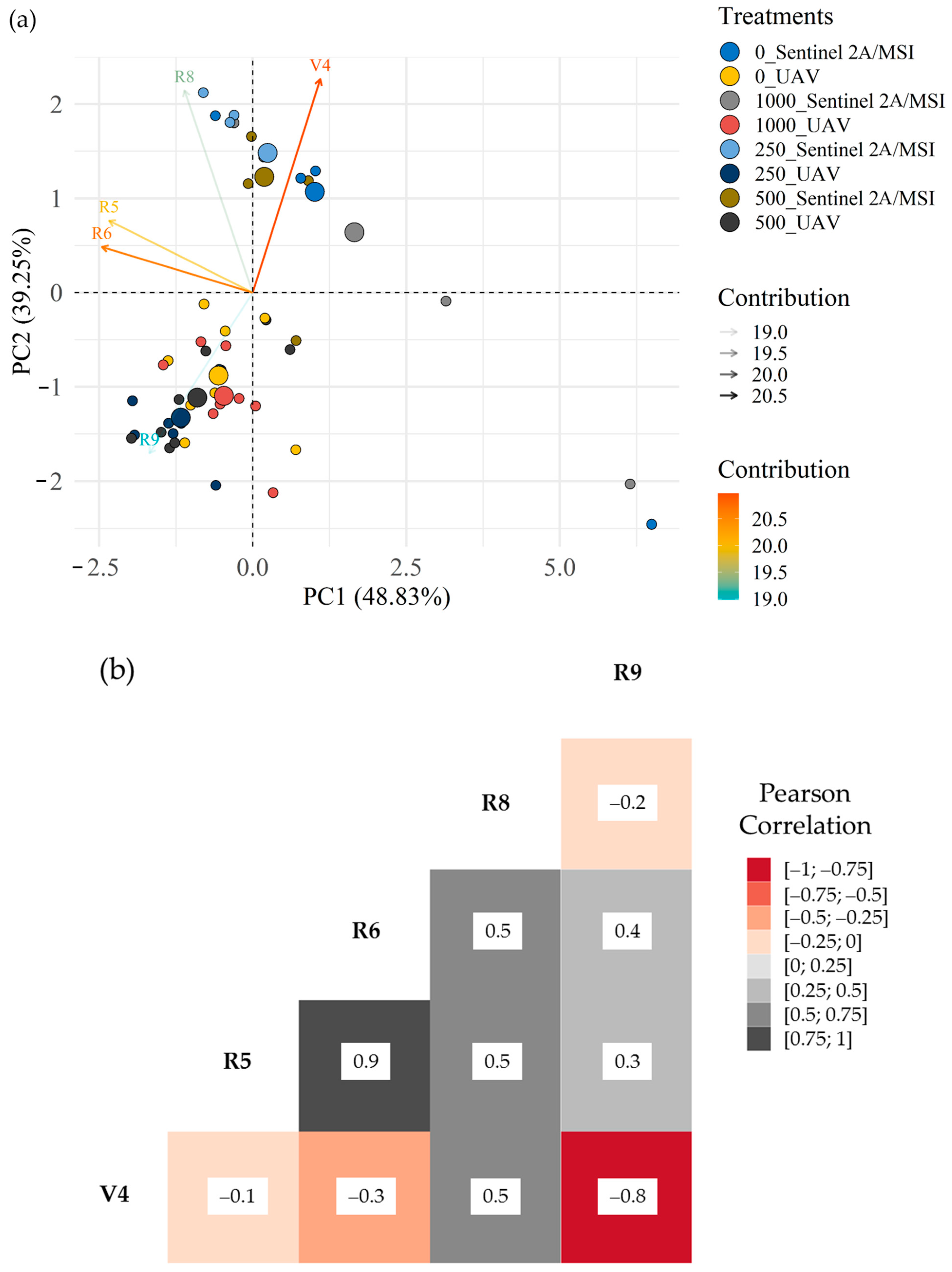
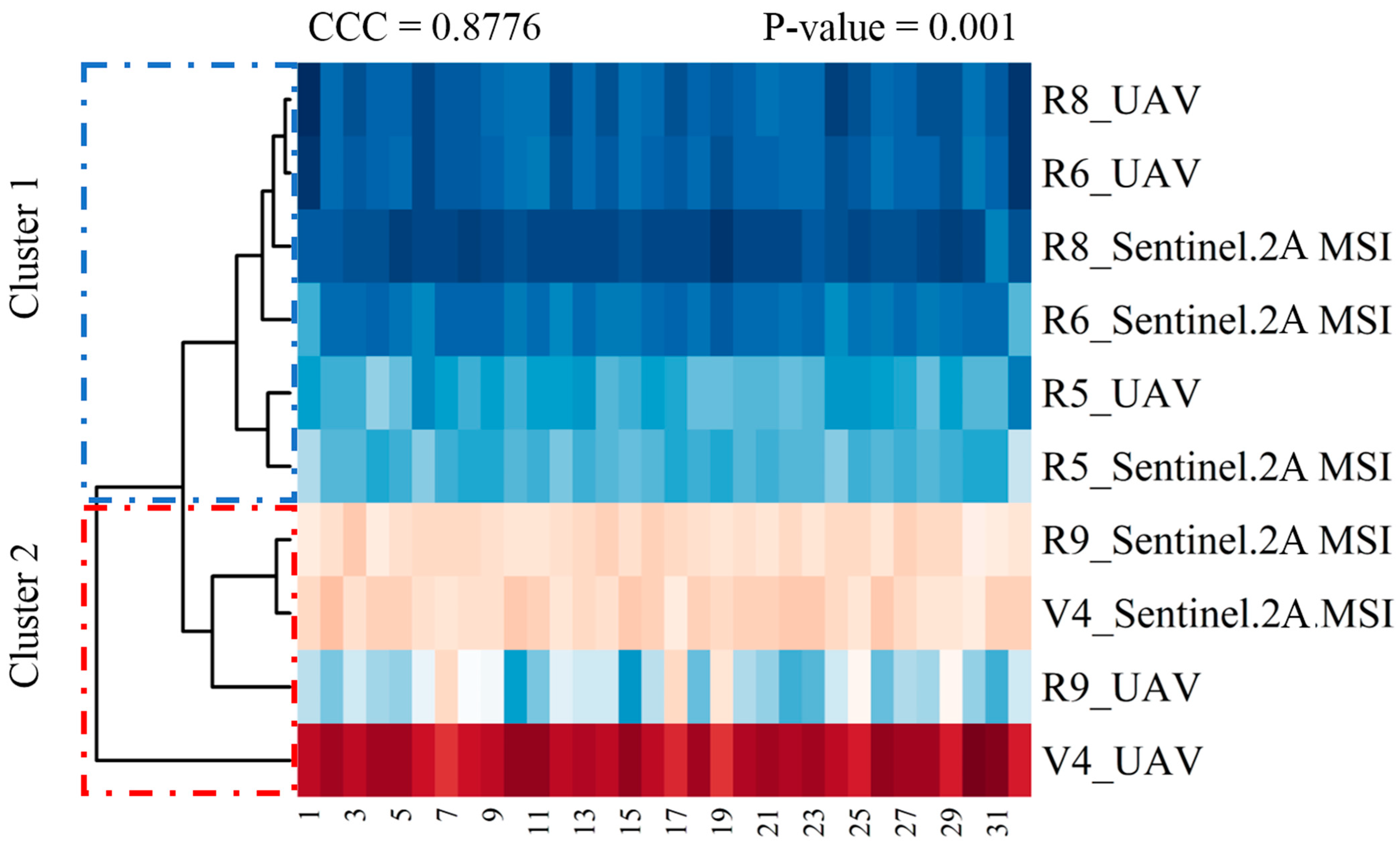
3.6. Multivariate Analysis: PCA and CCC from Sentinel-2A/MSI x UAV to Treatments (V4, R5, R6, R8, and R9)—Values of the NDVI
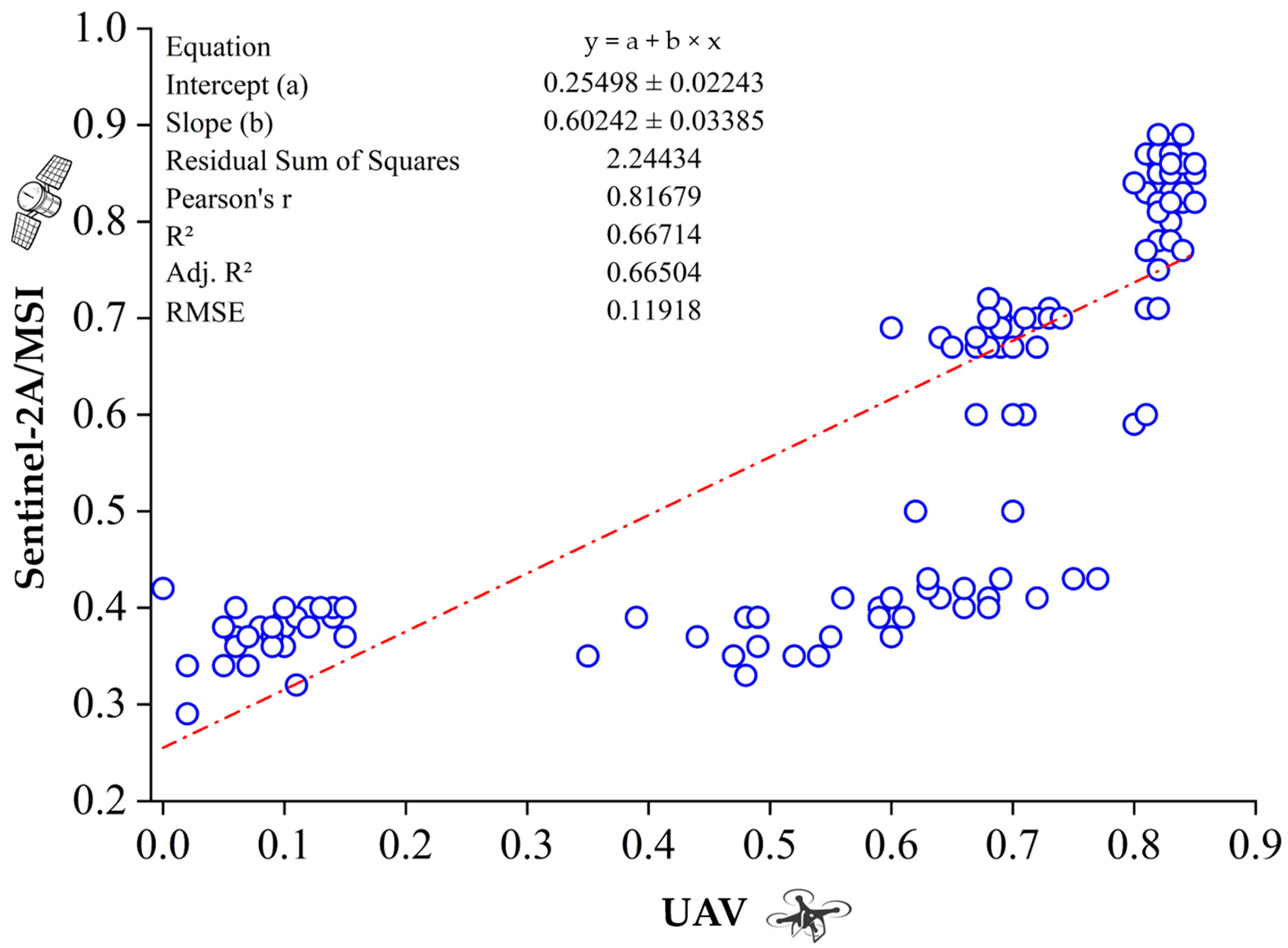
3.7. Multiple Regression Model: Sentinel-2A/MSI x UAV to Treatments (V4, R5, R6, R8, and R9)—Values of the NDVI
4. Discussion
4.1. Spectral Response UAV to Treatments
4.2. Satellite Data Analysis (Sentinel-2A/MSI)
4.3. Multivariate Analysis and Multiple Regression Model from Sentinel-2A/MSI x UAV to Treatments (V4, R5, R6, R8, and R9)
5. Conclusions
Author Contributions
Funding
Data Availability Statement
Acknowledgments
Conflicts of Interest
References
- Titolo, A. Use of Time-Series NDWI to Monitor Emerging Archaeological Sites: Case Studies from Iraqi Artificial Reservoirs. Remote Sens. 2021, 13, 786. [Google Scholar] [CrossRef]
- Stamford, J.D.; Vialet-Chabrand, S.; Cameron, I.; Lawson, T. Development of an Accurate Low Cost NDVI Imaging System for Assessing Plant Health. Plant Methods 2023, 19, 9. [Google Scholar] [CrossRef] [PubMed]
- Govi, D.; Pappalardo, S.E.; de Marchi, M.; Meggio, F. From Space to Field: Combining Satellite, UAV and Agronomic Data in an Open-Source Methodology for the Validation of NDVI Maps in Precision Viticulture. Remote Sens. 2024, 16, 735. [Google Scholar] [CrossRef]
- Széles, A.; Huzsvai, L.; Mohammed, S.; Nyéki, A.; Zagyi, P.; Horváth, É.; Simon, K.; Arshad, S.; Tamás, A. Precision Agricultural Technology for Advanced Monitoring of Maize Yield under Different Fertilization and Irrigation Regimes: A Case Study in Eastern Hungary (Debrecen). J. Agric. Food Res. 2024, 15, 100967. [Google Scholar] [CrossRef]
- de Sandrini, F.O.T.; Leal, F.T.; Coelho, A.P.; Lemos, L.B.; Rosalen, D.L. Vegetation Indices in the Estimation of Common Bean Yield Cultivated under Nitrogen Rates. Rev. Bras. Cienc. Agrar. 2019, 14, 2–9. [Google Scholar] [CrossRef]
- Kganyago, M.; Adjorlolo, C.; Mhangara, P.; Tsoeleng, L. Optical Remote Sensing of Crop Biophysical and Biochemical Parameters: An Overview of Advances in Sensor Technologies and Machine Learning Algorithms for Precision Agriculture. Comput. Electron. Agric. 2024, 218, 108730. [Google Scholar] [CrossRef]
- Mosleh, M.K.; Hassan, Q.K.; Chowdhury, E.H. Application of Remote Sensors in Mapping Rice Area and Forecasting Its Production: A Review. Sensors 2015, 15, 769–791. [Google Scholar] [CrossRef] [PubMed]
- Jiang, J.; Atkinson, P.M.; Chen, C.; Cao, Q.; Tian, Y.; Zhu, Y.; Liu, X.; Cao, W. Combining UAV and Sentinel-2 Satellite Multi-Spectral Images to Diagnose Crop Growth and N Status in Winter Wheat at the County Scale. Field Crops Res. 2023, 294, 108860. [Google Scholar] [CrossRef]
- Sahoo, R.N.; Rejith, R.G.; Gakhar, S.; Ranjan, R.; Meena, M.C.; Dey, A.; Mukherjee, J.; Dhakar, R.; Meena, A.; Daas, A.; et al. Drone Remote Sensing of Wheat N Using Hyperspectral Sensor and Machine Learning. Precis. Agric. 2024, 25, 704–728. [Google Scholar] [CrossRef]
- Zhang, L.; Zhang, H.; Niu, Y.; Han, W. Mapping Maize Water Stress Based on UAV Multispectral Remote Sensing. Remote Sens. 2019, 11, 605. [Google Scholar] [CrossRef]
- Shao, G.; Han, W.; Zhang, H.; Zhang, L.; Wang, Y.; Zhang, Y. Prediction of Maize Crop Coefficient from UAV Multisensor Remote Sensing Using Machine Learning Methods. Agric. Water Manag. 2023, 276, 108064. [Google Scholar] [CrossRef]
- Saravia, D.; Valqui-Valqui, L.; Salazar, W.; Quille-Mamani, J.; Barboza, E.; Porras-Jorge, R.; Injante, P.; Arbizu, C.I. Yield Prediction of Four Bean (Phaseolus Vulgaris) Cultivars Using Vegetation Indices Based on Multispectral Images from UAV in an Arid Zone of Peru. Drones 2023, 7, 325. [Google Scholar] [CrossRef]
- Killeen, P.; Kiringa, I.; Yeap, T.; Branco, P. Corn Grain Yield Prediction Using UAV-Based High Spatiotemporal Resolution Imagery, Machine Learning, and Spatial Cross-Validation. Remote Sens. 2024, 16, 683. [Google Scholar] [CrossRef]
- Agência Nacional de Aviação Civil (ANAC). Regulamento Brasileiro Da Aviação Civil (RBAC-E) No 94. Diário Oficial União 2021, 117, 1–34. [Google Scholar]
- Sankaran, S.; Quirós, J.J.; Miklas, P.N. Unmanned Aerial System and Satellite-Based High Resolution Imagery for High-Throughput Phenotyping in Dry Bean. Comput. Electron. Agric. 2019, 165, 104965. [Google Scholar] [CrossRef]
- Sankaran, S.; Zhou, J.; Khot, L.R.; Trapp, J.J.; Mndolwa, E.; Miklas, P.N. High-Throughput Field Phenotyping in Dry Bean Using Small Unmanned Aerial Vehicle Based Multispectral Imagery. Comput. Electron. Agric. 2018, 151, 84–92. [Google Scholar] [CrossRef]
- Andrade, R.G. Uso de Veículo Aéreo Não Tripulado (VANT). No Monitoramento dos Estádios de Desenvolvimento da Cultura Do Milho. In Embrapa Gado de Leite-Capítulo em Livro Técnico (INFOTECA-E); da Silva, H.C., Ed.; Engenharia Sanitária e Ambiental, Atena Editora: Ponta Grossa, Brazil, 2019; pp. 225–234. [Google Scholar]
- Javornik, T.; Carović-Stanko, K.; Gunjača, J.; Vidak, M.; Lazarević, B. Monitoring Drought Stress in Common Bean Using Chlorophyll Fluorescence and Multispectral Imaging. Plants 2023, 12, 1386. [Google Scholar] [CrossRef]
- Soriano-González, J.; Angelats, E.; Martínez-Eixarch, M.; Alcaraz, C. Monitoring Rice Crop and Yield Estimation with Sentinel-2 Data. Field Crops Res. 2022, 281, 108507. [Google Scholar] [CrossRef]
- Candiago, S.; Remondino, F.; De Giglio, M.; Dubbini, M.; Gattelli, M. Evaluating Multispectral Images and Vegetation Indices for Precision Farming Applications from UAV Images. Remote Sens. 2015, 7, 4026–4047. [Google Scholar] [CrossRef]
- de Souza, A.E.S.; Barbosa Júnior, M.R.; de Almeida Moreira, B.R.; da Silva, R.P.; Lemos, L.B. UAV Multispectral Data: A Reliable Approach for Managing Phosphate-Solubilizing Bacteria in Common Bean. Agronomy 2022, 12, 2284. [Google Scholar] [CrossRef]
- Plaza, J.; Criado, M.; Sánchez, N.; Pérez-Sánchez, R.; Palacios, C.; Charfolé, F. UAV Multispectral Imaging Potential to Monitor and Predict Agronomic Characteristics of Different Forage Associations. Agronomy 2021, 11, 1697. [Google Scholar] [CrossRef]
- Atzberger, C. Advances in Remote Sensing of Agriculture: Context Description, Existing Operational Monitoring Systems and Major Information Needs. Remote Sens. 2013, 5, 949–981. [Google Scholar] [CrossRef]
- Andrade, S.M.; Teodoro, L.P.R.; Baio, F.H.R.; Campos, C.N.S.; Roque, C.G.; da Silva, C.A., Jr.; Coradi, P.C.; Teodoro, P.E. High-Throughput Phenotyping of Soybean Genotypes under Base Saturation Stress Conditions. J. Agron. Crop Sci. 2021, 207, 814–822. [Google Scholar] [CrossRef]
- Clevers, J.G.P.W. Application of a Weighted Infrared-Red Vegetation Index for Estimating Leaf Area Index by Correcting for Soil Moisture. Remote Sens. Environ. 1989, 29, 25–37. [Google Scholar] [CrossRef]
- Tahir, N.; Li, J. Hyperspectral Remote Estimation of Leaf Nitrogen Content of Hyperspectral Remote Estimation of Leaf Nitrogen Content. Sci. Int. 2015, 27, 1689–1691. [Google Scholar]
- Naveed Tahir, M.; Lan, Y.; Zhang, Y.; Wang, Y.; Nawaz, F.; Arslan Ahmed Shah, M.; Gulzar, A.; Shahid Qureshi, W.; Manshoor Naqvi, S.; Zaigham Abbas Naqvi, S. Real Time Estimation of Leaf Area Index and Groundnut Yield Using Multispectral UAV. Int. J. Precis. Agric. Aviat. 2018, 1, 1–6. [Google Scholar] [CrossRef]
- Qi, H.; Zhu, B.; Kong, L.; Yang, W.; Zou, J.; Lan, Y.; Zhang, L. Hyperspectral Inversion Model of Chlorophyll Content in Peanut Leaves. Appl. Sci. 2020, 10, 2259. [Google Scholar] [CrossRef]
- Daughtry, C.S.T.; Gallo, K.P.; Bauer, M.E. Spectral Estimates of Solar Radiation Intercepted by Corn Canopies. Agron. J. 1983, 75, 527–531. [Google Scholar] [CrossRef]
- Jewan, S.Y.Y.; Pagay, V.; Billa, L.; Tyerman, S.D.; Gautam, D.; Sparkes, D.; Chai, H.H.; Singh, A. The Feasibility of Using a Low-Cost near-Infrared, Sensitive, Consumer-Grade Digital Camera Mounted on a Commercial UAV to Assess Bambara Groundnut Yield. Int. J. Remote Sens. 2022, 43, 393–423. [Google Scholar] [CrossRef]
- Du, M.; Noguchi, N. Monitoring of Wheat Growth Status and Mapping of Wheat Yield’s within-Field Spatial Variations Using Color Images Acquired from UAV-Camera System. Remote Sens. 2017, 9, 289. [Google Scholar] [CrossRef]
- Zhou, X.; Zheng, H.B.; Xu, X.Q.; He, J.Y.; Ge, X.K.; Yao, X.; Cheng, T.; Zhu, Y.; Cao, W.X.; Tian, Y.C. Predicting Grain Yield in Rice Using Multi-Temporal Vegetation Indices from UAV-Based Multispectral and Digital Imagery. ISPRS J. Photogramm. Remote Sens. 2017, 130, 246–255. [Google Scholar] [CrossRef]
- Wang, L.; Tian, Y.; Yao, X.; Zhu, Y.; Cao, W. Predicting Grain Yield and Protein Content in Wheat by Fusing Multi-Sensor and Multi-Temporal Remote-Sensing Images. Field Crops Res. 2014, 164, 178–188. [Google Scholar] [CrossRef]
- Sun, L.; Gao, F.; Anderson, M.C.; Kustas, W.P.; Alsina, M.M.; Sanchez, L.; Sams, B.; McKee, L.; Dulaney, W.; White, W.A.; et al. Daily Mapping of 30 m LAI and NDVI for Grape Yield Prediction in California Vineyards. Remote Sens. 2017, 9, 317. [Google Scholar] [CrossRef]
- Ranjan, R.; Chandel, A.K.; Khot, L.R.; Bahlol, H.Y.; Zhou, J.; Boydston, R.A.; Miklas, P.N. Irrigated Pinto Bean Crop Stress and Yield Assessment Using Ground Based Low Altitude Remote Sensing Technology. Inf. Process. Agric. 2019, 6, 502–514. [Google Scholar] [CrossRef]
- Pereira, V.G.C.; Gris, D.J.; Marangoni, T.; Frigo, J.P.; De Azevedo, K.D.; Grzesiuck, A.E. Exigências Agroclimáticas Para a Cultura Do Feijão (Phaseolus Vulgaris L.) Vinicius. Rev. Bras. Energ. Renov. 2014, 3, 32–42. [Google Scholar]
- Kano, C.; Cardoso, A.I.I.; Villas Bôas, R.L. Influencia de Doses de Potássio Nos Teores de Macronutrientes Em Plantas e Sementes de Alface. Hortic. Bras. 2010, 28, 287–291. [Google Scholar] [CrossRef]
- Canizella, B.T.; Moreira, A.; Moraes, L.A.C.; Fageria, N.K. Efficiency of Magnesium Use by Common Bean Varieties Regarding Yield, Physiological Components, and Nutritional Status of Plants. Commun. Soil. Sci. Plant Anal. 2015, 46, 1376–1390. [Google Scholar] [CrossRef]
- Zhou, J.; Khot, L.R.; Boydston, R.A.; Miklas, P.N.; Porter, L. Low Altitude Remote Sensing Technologies for Crop Stress Monitoring: A Case Study on Spatial and Temporal Monitoring of Irrigated Pinto Bean. Precis. Agric. 2018, 19, 555–569. [Google Scholar] [CrossRef]
- Parker, T.A.; Palkovic, A.; Gepts, P. Determining the Genetic Control of Common Bean Early-Growth Rate Using Unmanned Aerial Vehicles. Remote Sens. 2020, 12, 1748. [Google Scholar] [CrossRef]
- Lipovac, A.; Bezdan, A.; Moravčević, D.; Djurović, N.; Ćosić, M.; Benka, P.; Stričević, R. Correlation between Ground Measurements and UAV Sensed Vegetation Indices for Yield Prediction of Common Bean Grown under Different Irrigation Treatments and Sowing Periods. Water 2022, 14, 3786. [Google Scholar] [CrossRef]
- Santos, H.G.; Jacomine, P.K.T.; Anjos, L.H.C.; Oliveira, V.A.; Lumbreras Coelho, M.R.; Almeida, J.A.; Filho, A.J.C.; de Oliveira, J.B.; Cunha, T.J.F. Brazilian Soil Classification System, 5th ed.; Embrapa Soils: Brasília, Brazil, 2018; ISBN 9788570358219. [Google Scholar]
- Darim, E.P. Variabilidade Espacial De Atributos Físico-Hídricos Do Solo Em Área Irrigada. Master’s Thesis, Programa de Pós-Graduação em Irrigação no Cerrado, Instituto Federal Goiano—Campus Ceres, Ceres, Brazil, 2017; 104p. [Google Scholar]
- Peel, M.C.; Finlayson, B.L.; McMahon, T.A. Updated World Map of the Koppen-Geiger Climate Classificatio. Hydrol. Earth Syst. Sci. 2007, 11, 1633–1644. [Google Scholar] [CrossRef]
- Rouse, J.W.; Haas, R.H.; Schell, J.A.; Deering, D.W.; Harlan, J.C. Monitoring the Vernal Advancements and Retrogradation of Natural Vegetation; NASA Technical Reports Server (NTRS): Greenbelt, MD, USA, 1974; 137p. [Google Scholar]
- Gitelson, A.A.; Merzlyak, M.N. Remote Sensing of Chlorophyll Concentration in Higher Plant Leaves. Adv. Space Res. 1998, 22, 689–692. [Google Scholar] [CrossRef]
- Barnes, E.M.; Clarke, T.R.; Richards, S.E.; Colaizzi, P.D.; Haberland, J.; Kostrzewski, M.; Waller, P.; Choi, C.R.E.; Thompson, T.; Lascano, R.J.; et al. Coincident Detection of Crop Water Stress, Nitrogen Status and Canopy Density Using Ground Based Multispectral Data. In Proceedings of the 5th International Conference on Precision Agriculture, Bloomington, MN, USA, 16–19 July 2000. [Google Scholar]
- Daughtry, C.S.T.; Walthall, C.L.; Kim, M.S.; de Colstoun, E.B.; McMurtrey, J.E. Estimating Corn Leaf Chlorophyll Concentration from Leaf and Canopy Reflectance. Remote Sens. Environ. 2000, 74, 229–239. [Google Scholar] [CrossRef]
- Datt, B. A New Reflectance Index for Remote Sensing of Chlorophyll Content in Higher Plants: Tests Using Eucalyptus Leaves. J. Plant Physiol. 1999, 154, 30–36. [Google Scholar] [CrossRef]
- Peñuelas, J.; Frederic, B.; Filella, I. Semi-Empirical Indices to Assess Carotenoids/Chlorophyll a Ratio from Leaf Spectral Reflectance. Photosynthetica 1995, 31, 221–230. [Google Scholar]
- Gitelson, A.A.; Kaufman, Y.J.; Stark, R.; Rundquist, D. Novel Algorithms for Remote Estimation of Vegetation Fraction. Remote Sens. Environ. 2002, 80, 76–87. [Google Scholar] [CrossRef]
- Hunt, R.E.; Daughtry, C.S.T.; Eitel, J.U.H.; Long, D.S. Remote Sensing Leaf Chlorophyll Content Using a Visible Band Index. Agron. J. 2011, 103, 1090–1099. [Google Scholar] [CrossRef]
- Rouse, J.W.; Haas, R.H.; Schell, J.A.; Deering, D.W. Monitoring Vegetation Systems in the Great Plains with ERTS. NASA Spec. Publ. 1974, 351, 309. [Google Scholar]
- Huete, A.R. A Soil-Adjusted Vegetation Index (SAVI). Remote Sens. Environ. 1988, 25, 295–309. [Google Scholar] [CrossRef]
- Huete, A.; Didan, K.; Miura, T.; Rodriguez, E.P.; Gao, X.; Ferreira, L.G. Overview of the Radiometric and Biophysical Performance of the MODIS Vegetation Indices. Remote Sens. Environ. 2002, 83, 195–213. [Google Scholar] [CrossRef]
- Da Silva, J.L.B.; Moura, G.B.d.A.; da Silva, M.V.; de Oliveira-Júnior, J.F.; Jardim, A.M.d.R.F.; Refati, D.C.; Lima, R.d.C.C.; de Carvalho, A.A.; Ferreira, M.B.; de Brito, J.I.B.; et al. Environmental Degradation of Vegetation Cover and Water Bodies in the Semiarid Region of the Brazilian Northeast via Cloud Geoprocessing Techniques Applied to Orbital Data. J. S. Am. Earth Sci. 2023, 121, 104164. [Google Scholar] [CrossRef]
- Gao, B.C. NDWI—A Normalized Difference Water Index for Remote Sensing of Vegetation Liquid Water from Space. Remote Sens. Environ. 1996, 58, 257–266. [Google Scholar] [CrossRef]
- McFEETERS, S.K. The Use of the Normalized Difference Water Index (NDWI) in the Delineation of Open Water Features. Int. J. Remote Sens. 1996, 17, 1425–1432. [Google Scholar] [CrossRef]
- ESA. Sentinel-2 User Handbook, 1st ed.; European Space Agency: Paris, France, 2013. [Google Scholar]
- Gorelick, N.; Hancher, M.; Dixon, M.; Ilyushchenko, S.; Thau, D.; Moore, R. Google Earth Engine: Planetary-Scale Geospatial Analysis for Everyone. Remote Sens. Environ. 2017, 202, 18–27. [Google Scholar] [CrossRef]
- Tomasella, J.; Silva Pinto Vieira, R.M.; Barbosa, A.A.; Rodriguez, D.A.; de Oliveira Santana, M.; Sestini, M.F. Desertification Trends in the Northeast of Brazil over the Period 2000–2016. Int. J. Appl. Earth Obs. Geoinf. 2018, 73, 197–206. [Google Scholar] [CrossRef]
- Hallak, R.; Pereira Filho, A.J. Metodologia Para Análise de Desempenho de Simulações de Sistemas Convectivos Na Região Metropolitana de São Paulo Com o Modelo ARPS: Sensibilidade a Variações Com Os Esquemas de Advecção e Assimilação de Dados. Rev. Bras. Meteorol. 2011, 26, 591–608. [Google Scholar] [CrossRef]
- Figueiredo, D.B.; Silva Júnior, J.A. Desvendando Os Mistérios Do Coeficiente de Correlação de Pearson (r). Rev. Política Hoje 2009, 18, 115–146. [Google Scholar]
- Mukaka, M.M. Statistics Corner: A Guide to Appropriate Use of Correlation Coefficient in Medical Research. Malawi Med. J. 2012, 24, 69–71. [Google Scholar]
- Jardim, A.M.D.R.F.; Silva, M.V.D.; Silva, A.R.; Santos, A.D.; Pandorfi, H.; Oliveira-Júnior, J.F.D.; de Lima, J.L.M.P.; Souza, L.S.B.D.; Araújo Júnior, G.D.N.; Lopes, P.M.O.; et al. Spatiotemporal Climatic Analysis in Pernambuco State, Northeast Brazil. J. Atmos. Sol. Terr. Phys. 2021, 223, 105733. [Google Scholar] [CrossRef]
- Kaiser, H.F. The Varimax Criterion for Analytic Rotation in Factor Analysis. Psychometrika 1958, 23, 187–200. [Google Scholar] [CrossRef]
- de Oliveira-Júnior, J.F.; de Gois, G.; Silva, I.J.d.L.; de Oliveira Souza, E.; Jardim, A.M.d.R.F.; da Silva, M.V.; Shah, M.; Jamjareegulgarn, P. Wet and Dry Periods in the State of Alagoas (Northeast Brazil) via Standardized Precipitation Index. J. Atmos. Sol. Terr. Phys. 2021, 224, 105746. [Google Scholar] [CrossRef]
- Sokal, R.R.; Rohlf, F.J. The comparison of dendrograms by objective methods. Taxon 1962, 11, 33–40. [Google Scholar] [CrossRef]
- R Core Team. R: A Language and Environment for Statistical Computing. Available online: https://www.r-project.org/ (accessed on 6 February 2023).
- Yuan, M.; Burjel, J.C.; Martin, N.F.; Isermann, J.; Goeser, N.; Pittelkow, C.M. Advancing On-Farm Research with UAVs: Cover Crop Effects on Crop Growth and Yield. Agron. J. 2021, 113, 1071–1083. [Google Scholar] [CrossRef]
- Tisot, D.A. Modelos de Transferência Radiotiva No Estudo da Concentração de Clorofila em Cana-de-Açúcar, Utilizando Dados Hiperespectrais. 2009. Available online: http://mtc-m16c.sid.inpe.br/col/sid.inpe.br/mtc-m18@80/2009/07.06.19.44/doc/publicacao.pdf (accessed on 30 October 2023).
- Javed, A.; Ahmad, N.; Ahmed, J.; Hameed, A.; Ashraf, M.A.; Zafar, S.A.; Maqbool, A.; Al-Amrah, H.; Alatawi, H.A.; Al-Harbi, M.S.; et al. Grain Yield, Chlorophyll and Protein Contents of Elite Wheat Genotypes under Drought Stress. J. King Saud. Univ. Sci. 2022, 34, 102279. [Google Scholar] [CrossRef]
- Revill, A.; Florence, A.; MacArthur, A.; Hoad, S.; Rees, R.; Williams, M. Quantifying Uncertainty and Bridging the Scaling Gap in the Retrieval of Leaf Area Index by Coupling Sentinel-2 and UAV Observations. Remote Sens. 2020, 12, 1843. [Google Scholar] [CrossRef]
- Gitelson, A.A.; Kaufman, Y.J.; Merzlyak, M.N. Use of a Green Channel in Remote Sensing of Global Vegetation from EOS- MODIS. Remote Sens. Environ. 1996, 58, 289–298. [Google Scholar] [CrossRef]
- Shaul, O. Magnesium Transport and Function in Plants: The Tip of the Iceberg. BioMetals 2002, 15, 309–323. [Google Scholar] [CrossRef] [PubMed]
- Schmitz, P.K.; Kandel, H.J. Using Canopy Measurements to Predict Soybean Seed Yield. Remote Sens. 2021, 13, 3260. [Google Scholar] [CrossRef]
- Ji, Y.; Chen, Z.; Cheng, Q.; Liu, R.; Li, M.; Yan, X.; Li, G.; Wang, D.; Fu, L.; Ma, Y.; et al. Estimation of Plant Height and Yield Based on UAV Imagery in Faba Bean (Vicia Faba L.). Plant Methods 2022, 18, 26. [Google Scholar] [CrossRef]
- Spies, G.; Botelho, F.M.; Campos, S.C.; Poltronieri, K.C.; Ruffato, S. Efeito Do Espaçamento de Plantio e o Teor de Água Na Massa Específica e Massa de Mil Grãos Dos Grãos de Soja. In Proceedings of the Quinto Congresso de la Soja del Mercosur, Resumos Rosario, Argentina, 2011; pp. 1–5. [Google Scholar]
- Prudente, V.H.R.; Mercante, E.; Johann, J.A.; de Souza, C.H.W.; Cattani, C.E.V.; Mendes, I.S.; Caon, I.L. Use of Terrestrial Remote Sensing to Estimate Soybeans and Beans Biophysical Parameters. Geocarto Int. 2021, 36, 773–790. [Google Scholar] [CrossRef]
- Hussain, S.; Gao, K.; Din, M.; Gao, Y.; Shi, Z.; Wang, S. Assessment of UAV-Onboard Multispectral Sensor for Non-Destructive Site-Specific Rapeseed Crop Phenotype Variable at Different Phenological Stages and Resolutions. Remote Sens. 2020, 12, 397. [Google Scholar] [CrossRef]
- Din, M.; Zheng, W.; Rashid, M.; Wang, S.; Shi, Z. Evaluating Hyperspectral Vegetation Indices for Leaf Area Index Estimation of Oryza Sativa L. at Diverse Phenological Stages. Front. Plant Sci. 2017, 8, 820. [Google Scholar] [CrossRef] [PubMed]
- Zhao, Y.; Potgieter, A.B.; Zhang, M.; Wu, B.; Hammer, G.L. Predicting Wheat Yield at the Field Scale by Combining High-Resolution Sentinel-2 Satellite Imagery and Crop Modelling. Remote Sens. 2020, 12, 1024. [Google Scholar] [CrossRef]
- Bolton, D.K.; Friedl, M.A. Forecasting Crop Yield Using Remotely Sensed Vegetation Indices and Crop Phenology Metrics. Agric. For. Meteorol. 2013, 173, 74–84. [Google Scholar] [CrossRef]
- Moussa Kourouma, J.; Eze, E.; Negash, E.; Phiri, D.; Vinya, R.; Girma, A.; Zenebe, A. Assessing the Spatio-Temporal Variability of NDVI and VCI as Indices of Crops Productivity in Ethiopia: A Remote Sensing Approach. Geomat. Nat. Hazards Risk 2021, 12, 2880–2903. [Google Scholar] [CrossRef]
- da Silva, J.L.B.; Bezerra, A.C.; Moura, G.B.d.A.; Jardim, A.M.d.R.F.; Batista, P.H.D.; de Jesus, F.L.F.; Sanches, A.C.; da Silva, M.V. Spatiotemporal Dynamics of Agricultural Areas with Central Pivot Using Orbital Remote Sensing in the Brazilian Semiarid. Smart Agric. Technol. 2022, 2, 100052. [Google Scholar] [CrossRef]
- Filla, V.A.; Coelho, A.P.; Bettiol, J.V.T.; Leal, F.T.; Lemos, L.B.; Rosalen, D.L. Model Performance in Estimating the Yield of Common Bean Cultivars. Revista Ciência Agronômica 2023, 54, e20217835. [Google Scholar] [CrossRef]
- Barboza, T.O.C.; Ardigueri, M.; Souza, G.F.C.; Ferraz, M.A.J.; Gaudencio, J.R.F.; dos Santos, A.F. Performance of Vegetation Indices to Estimate Green Biomass Accumulation in Common Bean. AgriEngineering 2023, 5, 840–854. [Google Scholar] [CrossRef]
- Ibrahim, E.S.; Rufin, P.; Nill, L.; Kamali, B.; Nendel, C.; Hostert, P. Mapping Crop Types and Cropping Systems in Nigeria with Sentinel-2 Imagery. Remote Sens. 2021, 13, 3523. [Google Scholar] [CrossRef]
- San Bautista, A.; Fita, D.; Franch, B.; Castiñeira-Ibáñez, S.; Arizo, P.; Sánchez-Torres, M.J.; Becker-Reshef, I.; Uris, A.; Rubio, C. Crop Monitoring Strategy Based on Remote Sensing Data (Sentinel-2 and Planet), Study Case in a Rice Field after Applying Glycinebetaine. Agronomy 2022, 12, 708. [Google Scholar] [CrossRef]
- Schwarz, M.; Ouédraogo, W.A.; Traoré, I.; Müller, C.; Sié, A.; Barteit, S.; Mank, I.; Siegert, F.; Sauerborn, R.; Franke, J. Satellite-Based Multi-Annual Yield Models for Major Food Crops at the Household Field Level for Nutrition and Health Research: A Case Study from the Nouna HDSS, Burkina Faso. Int. J. Appl. Earth Obs. Geoinf. 2023, 117, 103203. [Google Scholar] [CrossRef]
- Refati, D.C.; da Silva, J.L.B.; Macedo, R.S.; Lima, R.d.C.C.; da Silva, M.V.; Pandorfi, H.; Silva, P.C.; de Oliveira-Júnior, J.F. Influence of Drought and Anthropogenic Pressures on Land Use and Land Cover Change in the Brazilian Semiarid Region. J. South. Am. Earth Sci. 2023, 126, 104362. [Google Scholar] [CrossRef]
- García-Berná, J.A.; Ouhbi, S.; Benmouna, B.; García-Mateos, G.; Fernández-Alemán, J.L.; Molina-Martínez, J.M. Systematic Mapping Study on Remote Sensing in Agriculture. Applied Sciences 2020, 10, 3456. [Google Scholar] [CrossRef]
- Zhao, L.; Shi, Y.; Liu, B.; Hovis, C.; Duan, Y.; Shi, Z. Finer Classification of Crops by Fusing UAV Images and Sentinel-2A Data. Remote Sens. 2019, 11, 3012. [Google Scholar] [CrossRef]



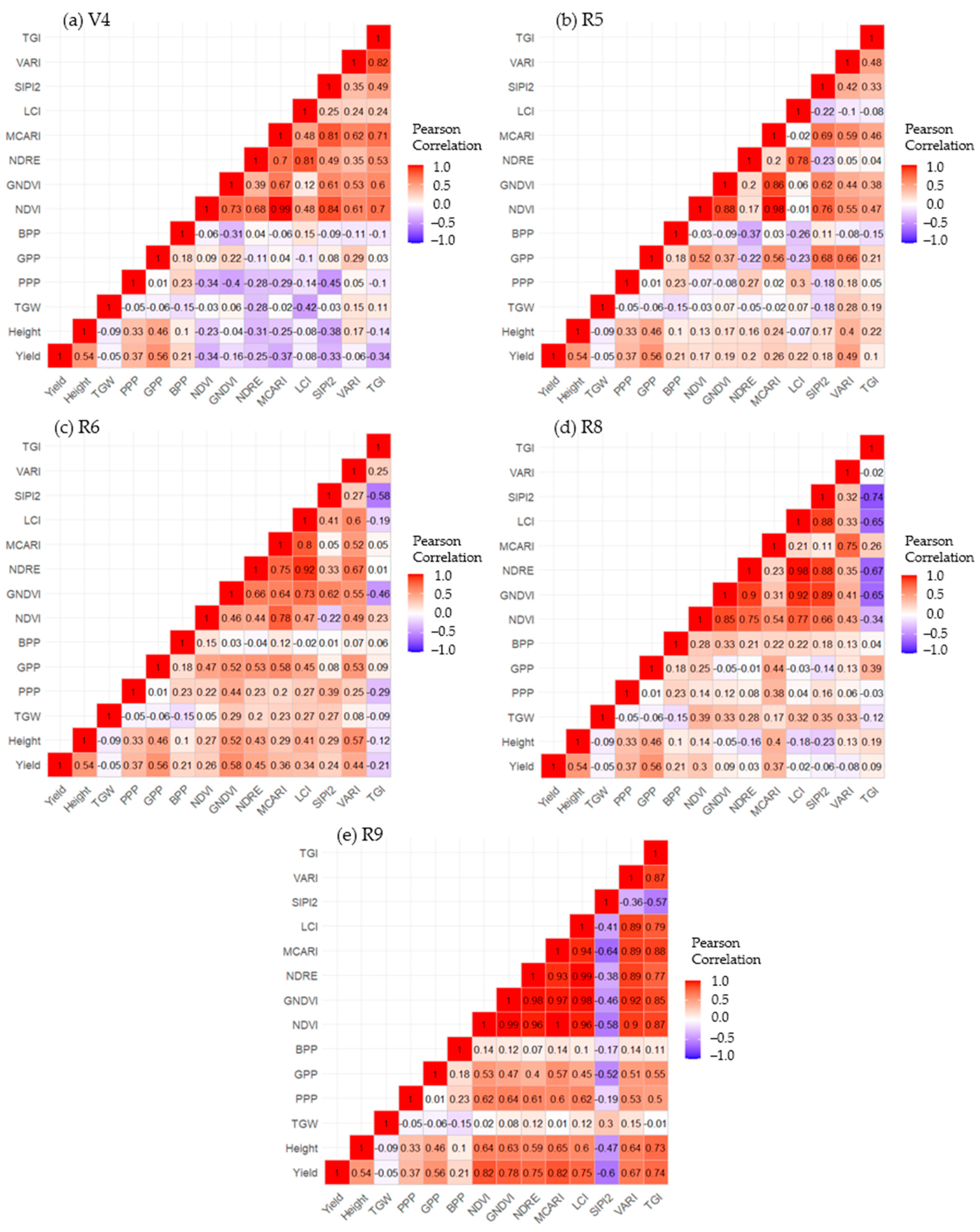
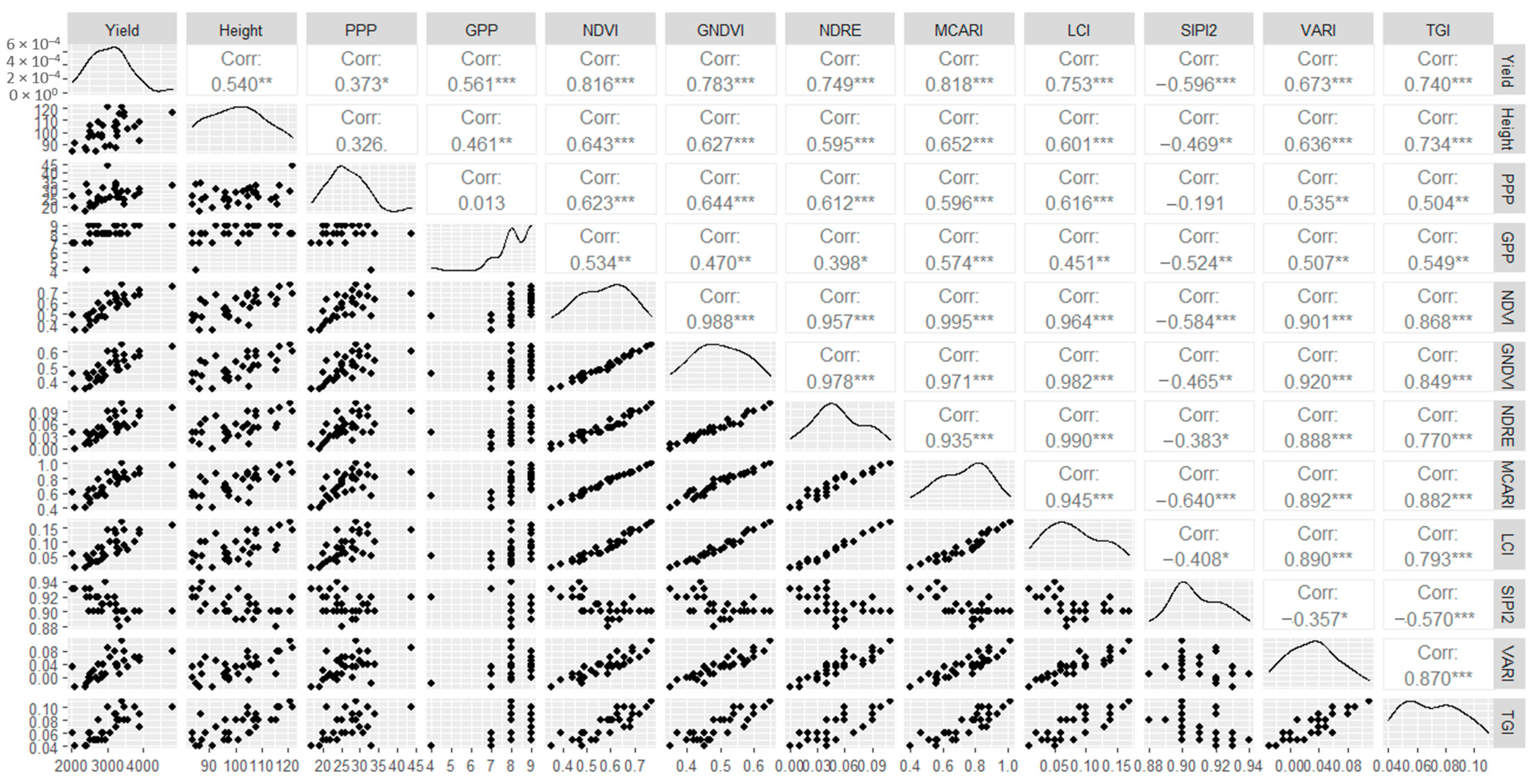

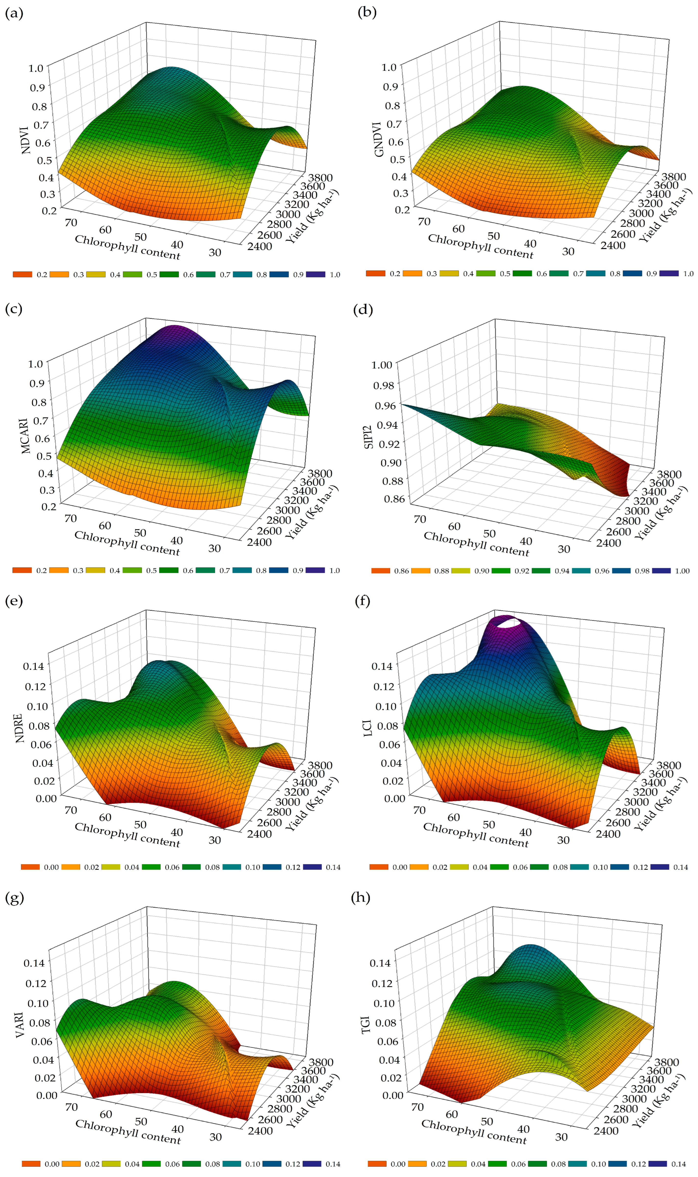

| Vegetation Indices | Acronym | Equation | References |
|---|---|---|---|
| Normalized Difference Vegetation Index | NDVI | [45] | |
| Green Normalized Difference Vegetation Index | GNDVI | [46] | |
| Normalized Difference Red Edge Index | NDRE | [47] | |
| Modified Chlorophyll Absorption in Reflective Index | MCARI | [48] | |
| Leaf Chlorophyll Index | LCI | [49] | |
| Structure Insensitive Pigment Index 2 | SIPI2 | [50] | |
| Visible Atmospherically Resistant Index | VARI | [51] | |
| Triangular Greenness Index | TGI | [52] |
| Band Name | Center Wavelength | Temporal Resolution | Spatial Resolution | Radiometric Resolution | Processing Level |
|---|---|---|---|---|---|
| rGREEN | 560 nm | 10/5 days | 10 m | 16 bits | L2A |
| rRED | 665 nm | 10/5 days | 10 m | 16 bits | L2A |
| rNIR | 842 nm | 10/5 days | 10 m | 16 bits | L2A |
| rVegetation Red Edge | 865 nm | 10/5 days | 20 m | 16 bits | L2A |
| rSWIR 1 | 1610 m | 10/5 days | 20 m | 16 bits | L2A |
| IVs | Phenological Stage | |||||||||
|---|---|---|---|---|---|---|---|---|---|---|
| V4 | R5 | R6 | R8 | R9 | ||||||
| r | RMSE | r | RMSE | r | RMSE | r | RMSE | r | RMSE | |
| NDVI | −0.23 ns | 10.6 | 0.13 ns | 10.8 | 0.27 ns | 10.5 | 0.14 ns | 10.8 | 0.64 ** | 8.3 |
| GNDVI | −0.04 ns | 10.9 | 0.17 ns | 10.8 | 0.52 ** | 9.4 | −0.05 ns | 10.9 | 0.63 ** | 8.5 |
| NDRE | −0.31 ns | 10.4 | 0.16 ns | 10.8 | 0.43 * | 9.9 | −0.16 ns | 10.8 | 0.59 ** | 8.8 |
| MCARI | −0.25 ns | 10.6 | 0.24 ns | 10.6 | 0.29 ns | 10.5 | 0.40 * | 10.0 | 0.65 ** | 8.3 |
| LCI | −0.08 ns | 10.9 | −0.07 ns | 10.9 | 0.41 * | 10.0 | −0.18 ns | 10.8 | 0.60 ** | 8.7 |
| SIPI2 | −0.38 * | 10.1 | 0.17 ns | 10.8 | 0.29 ns | 10.5 | −0.23 ns | 10.6 | −0.47 ** | 9.7 |
| VARI | 0.17 ns | 10.8 | 0.40 * | 10.0 | 0.57 ** | 9.0 | 0.13 ns | 10.9 | 0.64 ** | 8.4 |
| TGI | −0.14 ns | 10.8 | 0.22 ns | 10.7 | −0.12 ns | 10.9 | 0.19 ns | 10.8 | 0.73 ** | 7.4 |
| IVs | Phenological Stage | |||||||||
|---|---|---|---|---|---|---|---|---|---|---|
| V4 | R5 | R6 | R8 | R9 | ||||||
| R | RMSE | r | RMSE | r | RMSE | r | RMSE | r | RMSE | |
| NDVI | −0.34 ns | 4.9 | −0.07 ns | 5.2 | 0.22 ns | 5.1 | 0.14 ns | 5.2 | 0.62 ** | 4.1 |
| GNDVI | −0.40 * | 4.8 | −0.08 ns | 5.2 | 0.44 * | 4.7 | 0.12 ns | 5.2 | 0.64 ** | 4.0 |
| NDRE | −0.28 ns | 5.0 | 0.27 ns | 5.0 | 0.23 ns | 5.1 | 0.08 ns | 5.2 | 0.61 ** | 4.1 |
| MCARI | −0.29 ns | 5.0 | 0.02 ns | 5.2 | 0.20 ns | 5.1 | 0.38 * | 4.8 | 0.60 ** | 4.1 |
| LCI | −0.14 ns | 5.2 | 0.30 ns | 5.0 | 0.27 ns | 5.0 | 0.04 ns | 5.2 | 0.62 ** | 4.1 |
| SIPI2 | −0.45 ** | 4.7 | −0.18 ns | 5.1 | 0.39 * | 4.8 | 0.16 ns | 5.2 | −0.19 ns | 5.1 |
| VARI | 0.05 ns | 5.2 | 0.18 ns | 5.1 | 0.25 ns | 5.1 | 0.06 ns | 5.2 | 0.53 ** | 4.3 |
| TGI | −0.10 ns | 5.19 | 0.05 ns | 5.2 | −0.29 ns | 5.0 | −0.03 ns | 5.2 | 0.50 ** | 4.5 |
| IVs | Phenological Stage | |||||||||
|---|---|---|---|---|---|---|---|---|---|---|
| V4 | R5 | R6 | R8 | R9 | ||||||
| R | RMSE | r | RMSE | r | RMSE | r | RMSE | r | RMSE | |
| NDVI | 0.09 ns | 1.0 | 0.52 ** | 0.8 | 0.47 ** | 0.9 | 0.25 ns | 1.0 | 0.53 ** | 0.8 |
| GNDVI | 0.22 ns | 0.9 | 0.37 * | 0.9 | 0.52 ** | 0.8 | −0.05 ns | 1.0 | 0.47 ** | 0.9 |
| NDRE | −0.11 ns | 1.0 | −0.22 ns | 1.0 | 0.53 ** | 0.8 | −0.01 ns | 1.0 | 0.40 * | 0.9 |
| MCARI | 0.04 ns | 1.0 | 0.56 ** | 0.8 | 0.58 ** | 0.8 | 0.44 * | 0.9 | 0.57 ** | 0.8 |
| LCI | −0.10 ns | 1.0 | −0.22 ns | 1.0 | 0.45 ** | 0.8 | −0.03 ns | 1.0 | 0.45 ** | 0.9 |
| SIPI2 | 0.08 ns | 1.0 | 0.68 ** | 0.7 | 0.08 ns | 1.0 | −0.14 ns | 1.0 | −0.52 ** | 0.8 |
| VARI | 0.29 ns | 0.9 | 0.66 ** | 0.7 | 0.53 ** | 0.8 | 0.13 ns | 1.0 | 0.51 ** | 0.8 |
| TGI | 0.03 ns | 1.0 | 0.21 ns | 1.0 | 0.09 ns | 1.0 | 0.39 * | 0.9 | 0.55 ** | 0.8 |
| IVs | Phenological Stage | |||||||||
|---|---|---|---|---|---|---|---|---|---|---|
| V4 | R5 | R6 | R8 | R9 | ||||||
| r | RMSE | r | RMSE | r | RMSE | R | RMSE | r | RMSE | |
| NDVI | −0.34 ns | 538 | 0.17 ns | 564 | 0.26 ns | 553 | 0.30 ns | 544 | 0.82 ** | 330 |
| GNDVI | −0.16 ns | 565 | 0.19 ns | 562 | 0.58 ** | 465 | 0.09 ns | 570 | 0.78 ** | 355 |
| NDRE | −0.25 ns | 554 | 0.20 ns | 560 | 0.45 ** | 510 | 0.03 ns | 571 | 0.75 ** | 379 |
| MCARI | −0.37 * | 532 | 0.26 ns | 552 | 0.36 * | 533 | 0.37 * | 530 | 0.82 ** | 329 |
| LCI | −0.08 ns | 570 | 0.22 ns | 558 | 0.34 ns | 538 | −0.02 ns | 572 | 0.75 ** | 376 |
| SIPI2 | −0.33 ns | 540 | 0.18 ns | 562 | 0.24 ns | 555 | −0.06 ns | 571 | −0.60 ** | 459 |
| VARI | −0.06 ns | 571 | 0.49 ** | 498 | 0.44 * | 512 | −0.08 ns | 570 | 0.67 ** | 423 |
| TGI | −0.34 ns | 538 | 0.10 ns | 569 | −0.21 ns | 558 | 0.09 ns | 569 | 0.74 ** | 385 |
| IVs | Phenological Stage | |||||||||
|---|---|---|---|---|---|---|---|---|---|---|
| V4 | R5 | R6 | R8 | R9 | ||||||
| r | RMSE | r | RMSE | r | RMSE | r | RMSE | r | RMSE | |
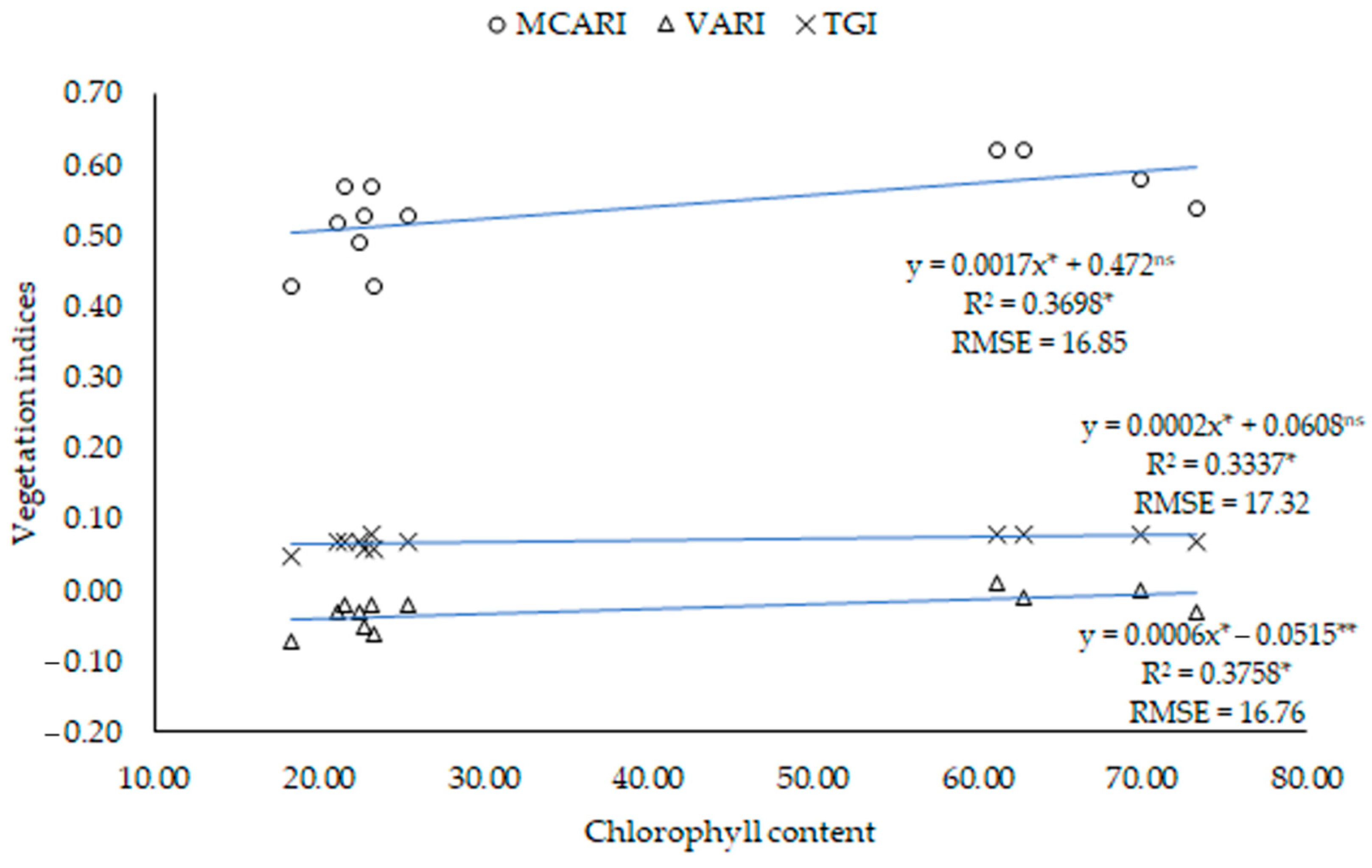
| NDVI | −0.21 ns | 4.35 | 0.41 ns | 19.31 | −0.02 ns | 18.60 | 0.29 ns | 23.43 | 0.81 ** | 10.19 |
| GNDVI | −0.14 ns | 4.35 | 0.19 ns | 20.80 | −0.11 ns | 18.49 | 0.04 ns | 24.51 | 0.78 ** | 10.72 |
| NDRE | 0.04 ns | 4.35 | 0.45 ns | 18.89 | −0.05 ns | 18.60 | 0.12 ns | 24.35 | 0.79 ** | 10.58 |
| MCARI | −0.16 ns | 4.35 | 0.60 * | 16.85 | 0.13 ns | 18.46 | 0.24 ns | 23.76 | 0.81 ** | 10.14 |
| LCI | −0.03 ns | 4.35 | 0.40 ns | 19.41 | 0.12 ns | 18.46 | 0.11 ns | 24.39 | 0.79 ** | 10.58 |
| SIPI2 | −0.12 ns | 4.35 | −0.04 ns | 21.21 | −0.005 ns | 18.60 | 0.14 ns | 24.28 | −0.48 ns | 15.16 |
| VARI | −0.17 ns | 4.35 | 0.61 * | 16.76 | 0.09 ns | 18.52 | 0.25 ns | 23.68 | 0.77 ** | 10.90 |
| TGI | 0.15 ns | 4.35 | 0.57 * | 17.32 | 0.18 ns | 18.27 | 0.05 ns | 24.49 | 0.59 * | 14.03 |
Disclaimer/Publisher’s Note: The statements, opinions and data contained in all publications are solely those of the individual author(s) and contributor(s) and not of MDPI and/or the editor(s). MDPI and/or the editor(s) disclaim responsibility for any injury to people or property resulting from any ideas, methods, instructions or products referred to in the content. |
© 2024 by the authors. Licensee MDPI, Basel, Switzerland. This article is an open access article distributed under the terms and conditions of the Creative Commons Attribution (CC BY) license (https://creativecommons.org/licenses/by/4.0/).
Share and Cite
de Oliveira, H.F.E.; de Castro, L.E.V.; Sousa, C.M.; Alves Júnior, L.R.; Mesquita, M.; Silva, J.A.O.S.; Faria, L.C.; da Silva, M.V.; Giongo, P.R.; de Oliveira Júnior, J.F.; et al. Geotechnologies in Biophysical Analysis through the Applicability of the UAV and Sentinel-2A/MSI in Irrigated Area of Common Beans: Accuracy and Spatial Dynamics. Remote Sens. 2024, 16, 1254. https://doi.org/10.3390/rs16071254
de Oliveira HFE, de Castro LEV, Sousa CM, Alves Júnior LR, Mesquita M, Silva JAOS, Faria LC, da Silva MV, Giongo PR, de Oliveira Júnior JF, et al. Geotechnologies in Biophysical Analysis through the Applicability of the UAV and Sentinel-2A/MSI in Irrigated Area of Common Beans: Accuracy and Spatial Dynamics. Remote Sensing. 2024; 16(7):1254. https://doi.org/10.3390/rs16071254
Chicago/Turabian Stylede Oliveira, Henrique Fonseca Elias, Lucas Eduardo Vieira de Castro, Cleiton Mateus Sousa, Leomar Rufino Alves Júnior, Marcio Mesquita, Josef Augusto Oberdan Souza Silva, Lessandro Coll Faria, Marcos Vinícius da Silva, Pedro Rogerio Giongo, José Francisco de Oliveira Júnior, and et al. 2024. "Geotechnologies in Biophysical Analysis through the Applicability of the UAV and Sentinel-2A/MSI in Irrigated Area of Common Beans: Accuracy and Spatial Dynamics" Remote Sensing 16, no. 7: 1254. https://doi.org/10.3390/rs16071254
APA Stylede Oliveira, H. F. E., de Castro, L. E. V., Sousa, C. M., Alves Júnior, L. R., Mesquita, M., Silva, J. A. O. S., Faria, L. C., da Silva, M. V., Giongo, P. R., de Oliveira Júnior, J. F., de Siqueira, V. S., & da Silva, J. L. B. (2024). Geotechnologies in Biophysical Analysis through the Applicability of the UAV and Sentinel-2A/MSI in Irrigated Area of Common Beans: Accuracy and Spatial Dynamics. Remote Sensing, 16(7), 1254. https://doi.org/10.3390/rs16071254


