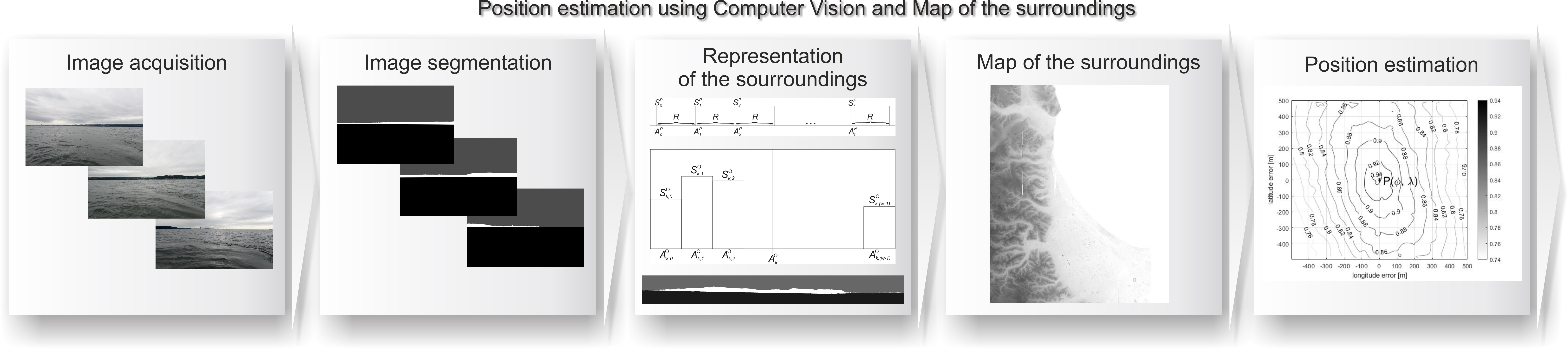
Computer Vision-Based Position Estimation for an Autonomous Underwater Vehicle



Abstract
1. Introduction
- 1.
- Proposal of an algorithm for estimating the position of ships in coastal areas;
- 2.
- The algorithm is designed for GNSS and environments in which radio navigational signals are denied;
- 3.
- The algorithm’s effectiveness has been verified under real-world conditions.
2. Related Work
3. Architecture Overview
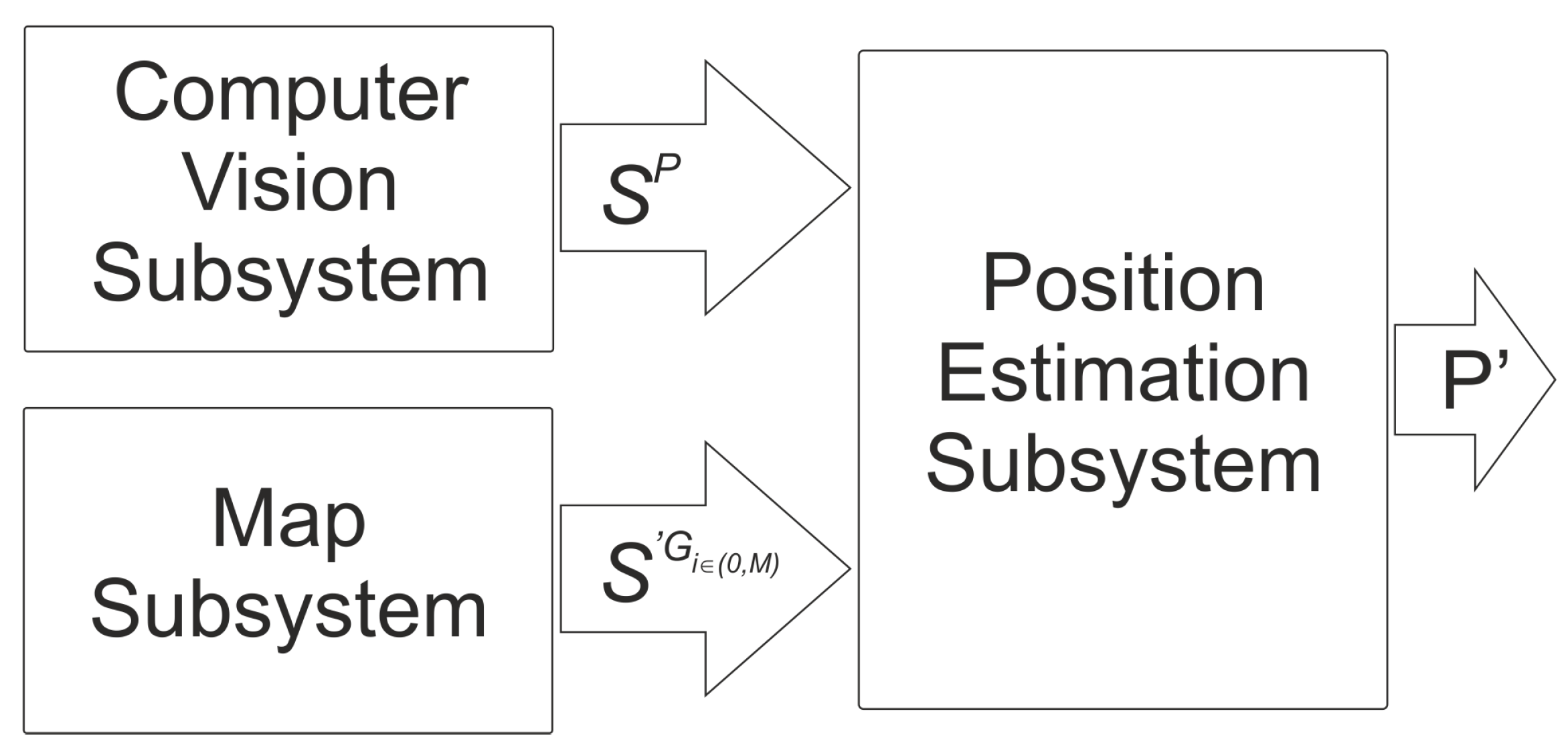
3.1. Computer Vision Subsystem
3.2. Map Subsystem

3.3. Position Estimation Subsystem
4. Experiments
4.1. Dataset
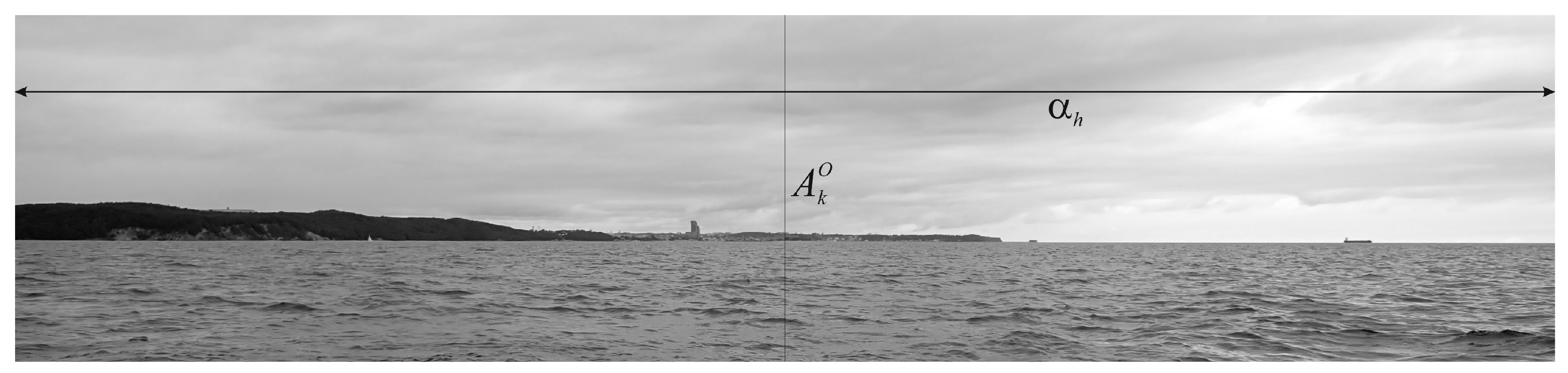
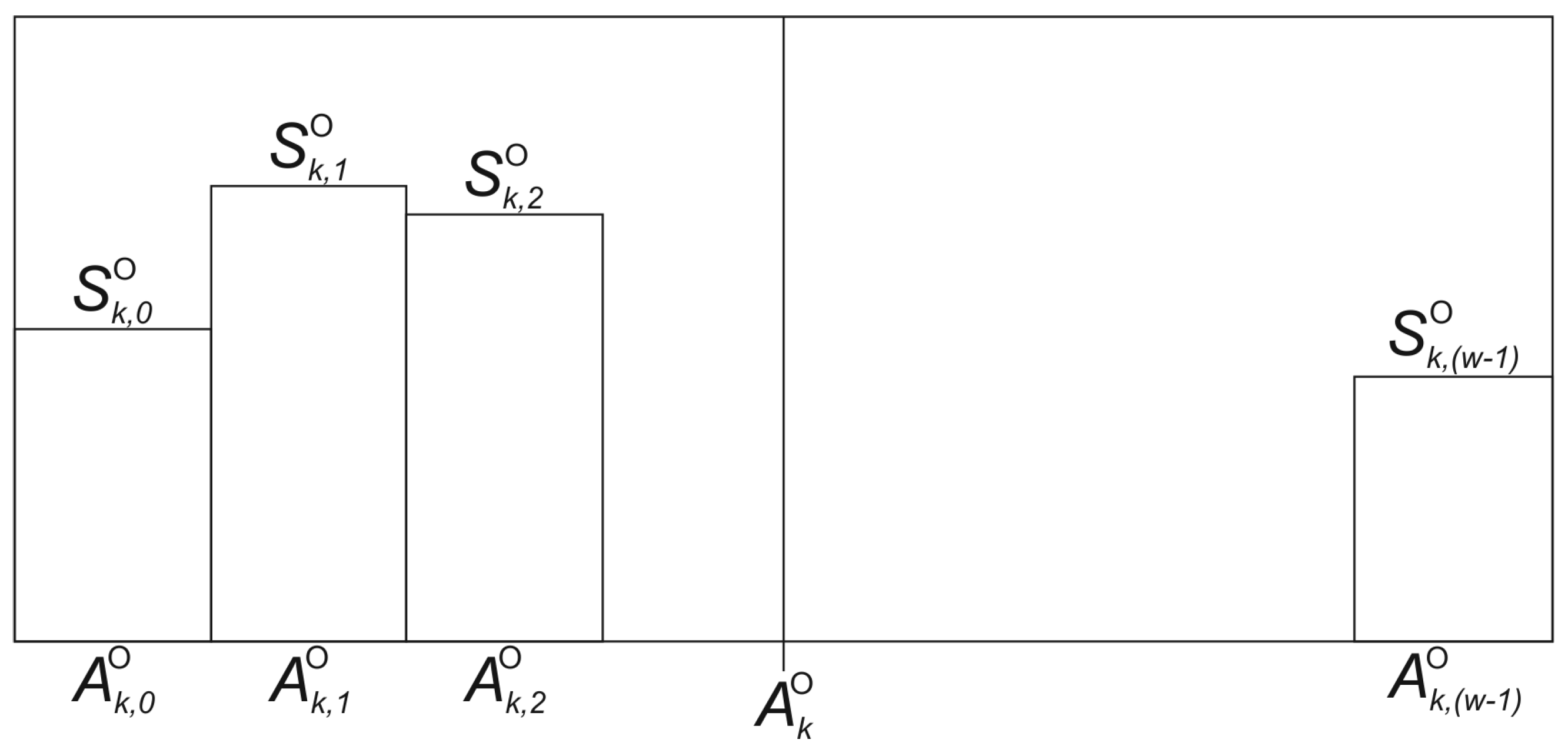
4.2. Representation of the Surroundings
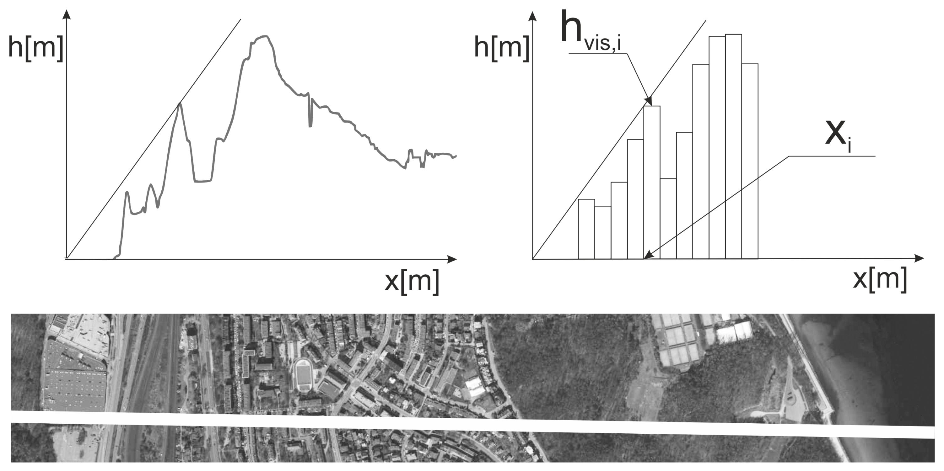
4.3. Map of the Surroundings
4.4. A Measure of the Similarity of Representations
5. Experimental Results
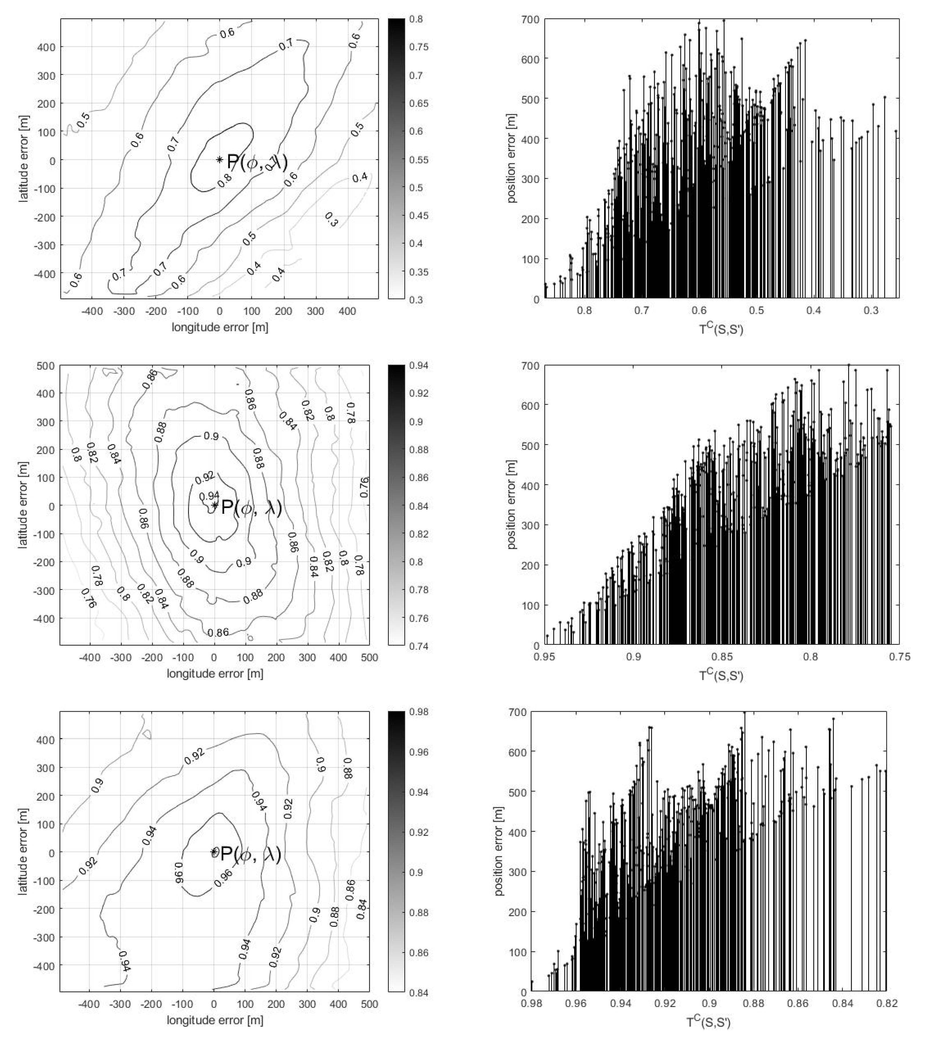
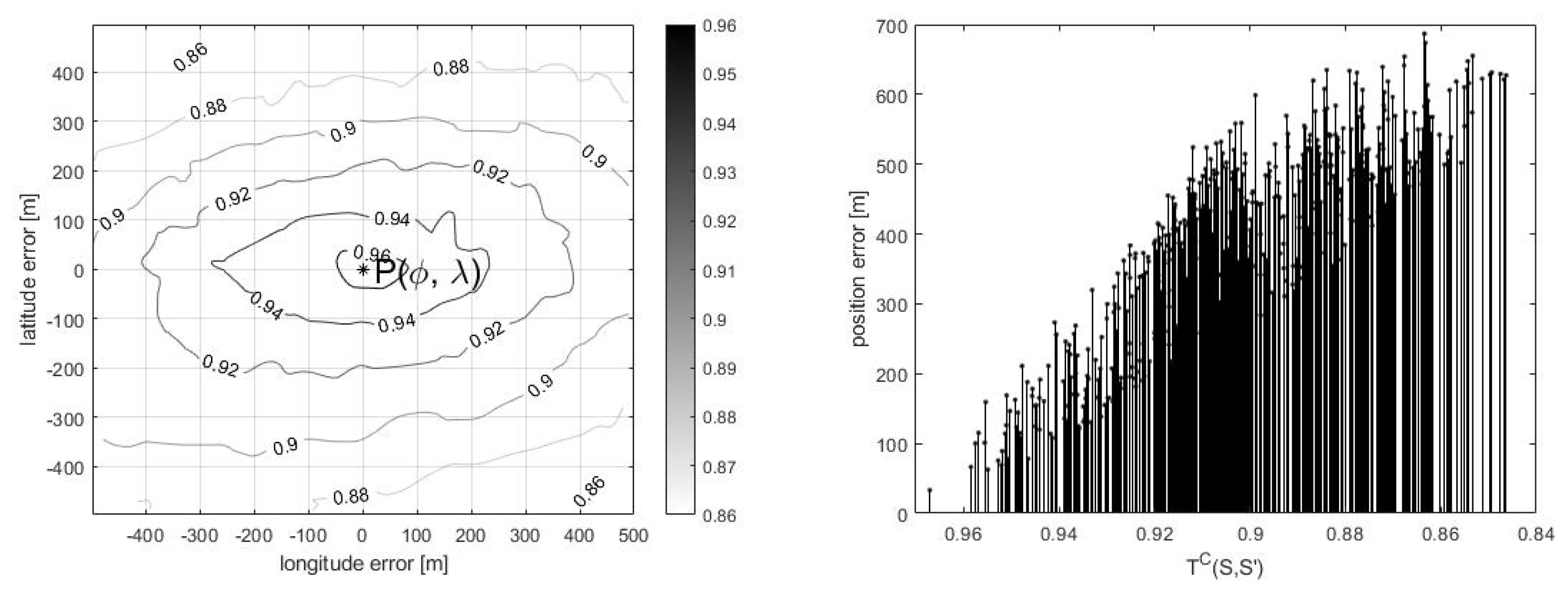

| Removed Part | n | Min [m] | Max [m] | Average [m] |
|---|---|---|---|---|
| 10% | 180 | 5.21 | 54.19 | 40.87 |
| 10% | 720 | 7.87 | 74.02 | 29.08 |
| 10% | 1800 | 4.17 | 62.94 | 47.78 |
| 30% | 180 | 8.03 | 81.09 | 46.26 |
| 30% | 720 | 14.01 | 101.29 | 69.01 |
| 30% | 1800 | 10.65 | 57.94 | 36.28 |
| 50% | 180 | 42.39 | 179.03 | 130.97 |
| 50% | 720 | 38.67 | 237.14 | 158.30 |
| 50% | 1800 | 49.49 | 213.59 | 143.00 |
6. Future Research
7. Conclusions
- 1.
- Convolutional neural networks accurately extract land features from marine imagery. This highlights the effectiveness of advanced machine learning techniques in the field of maritime image analysis.
- 2.
- The proposed algorithm reduces the error associated with dead reckoning navigation systems to 30–60 m. This indicates the algorithm’s effectiveness in improving the accuracy of AUV navigation, particularly in challenging maritime environments.
- 3.
- The resilience of the algorithm is highlighted by its ability to operate effectively even in scenarios where land representation is incomplete. This adaptability is crucial for real-world applications where environmental conditions may limit the availability of comprehensive map data.
- 4.
- The proposed algorithm proves to be a robust means for developing a fully autonomous AUV navigation system. It shows particular promise in environments where access to GNSS signals is limited, positioning it as a viable solution for GNSS-denied scenarios. This capability opens up avenues for autonomous task performance in challenging maritime conditions, contributing to the advancement of AUV technology.
Author Contributions
Funding
Data Availability Statement
Conflicts of Interest
Abbreviations
| AUV | Autonomous Underwater Vehicle |
| DGPS | Differential Global Positioning System |
| DSM | Digital Surface Model |
| GNSS | Global Navigation Satellite System |
| GPS | Global Positioning System |
| IMU | Inertial Measurement Unit |
| MEMS | Microelectromechanical System |
| LBL | Long Baseline |
| LIDAR | Light Detection and Ranging |
| ROUV | Remotely Operated Underwater Vehicle |
| SBL | Short Baseline |
| SCU | Surface Control Unit |
| SLAM | Simultaneous Localization and Mapping |
| UAV | Unmanned Aerial Vehicle |
| USBL | Ultra Short Baseline |
| UUV | Unmanned Underwater Vehicle |
References
- Sahoo, A.; Dwivedy, S.K.; Robi, P. Advancements in the field of autonomous underwater vehicle. Ocean Eng. 2019, 181, 145–160. [Google Scholar] [CrossRef] [Scilit]
- Bovio, E.; Cecchi, D.; Baralli, F. Autonomous underwater vehicles for scientific and naval operations. Annu. Rev. Control 2006, 30, 117–130. [Google Scholar] [CrossRef] [Scilit]
- Joochim, C.; Phadungthin, R.; Srikitsuwan, S. Design and development of a Remotely Operated Underwater Vehicle. In Proceedings of the 2015 16th International Conference on Research and Education in Mechatronics (REM), Bochum, Germany, 18–20 November 2015; pp. 148–153. [Google Scholar] [CrossRef] [Scilit]
- He, Y.; Wang, D.B.; Ali, Z.A. A review of different designs and control models of remotely operated underwater vehicle. Meas. Control 2020, 53, 1561–1570. [Google Scholar] [CrossRef] [Scilit]
- Maurelli, F.; Krupiński, S.; Xiang, X.; Petillot, Y. AUV Localisation: A Review of Passive and Active Techniques; Springer: Berlin/Heidelberg, Germany, 2021. [Google Scholar] [CrossRef] [Scilit]
- Xie, Y.x.; Liu, J.; Hu, C.q.; Cui, J.h.; Xu, H. AUV Dead-Reckoning Navigation Based on Neural Network Using a Single Accelerometer. In Proceedings of the 11th ACM International Conference on Underwater Networks & Systems, Shanghai, China, 24–26 October 2016. [Google Scholar] [CrossRef] [Scilit]
- Brossard, M.; Barrau, A.; Bonnabel, S. AI-IMU Dead-Reckoning. IEEE Trans. Intell. Veh. 2020, 5, 585–595. [Google Scholar] [CrossRef] [Scilit]
- Rogne, R.H.; Bryne, T.H.; Fossen, T.I.; Johansen, T.A. MEMS-based Inertial Navigation on Dynamically Positioned Ships: Dead Reckoning. IFAC-PapersOnLine 2016, 49, 139–146. [Google Scholar] [CrossRef] [Scilit]
- Chu, Z.; Zhu, D.; Sun, B.; Nie, J.; Xue, D. Design of a dead reckoning based motion control system for small autonomous underwater vehicle. In Proceedings of the 2015 IEEE 28th Canadian Conference on Electrical and Computer Engineering (CCECE), Halifax, NS, Canada, 3–6 May 2015; pp. 728–733. [Google Scholar] [CrossRef] [Scilit]
- De Agostino, M.; Manzino, A.M.; Piras, M. Performances comparison of different MEMS-based IMUs. In Proceedings of the IEEE/ION Position, Location and Navigation Symposium, Indian Wells, CA, USA, 4–6 May 2010; pp. 187–201. [Google Scholar] [CrossRef] [Scilit]
- Vitale, G.; D’Alessandro, A.; Costanza, A.; Fagiolini, A. Low-cost underwater navigation systems by multi-pressure measurements and AHRS data. In Proceedings of the OCEANS 2017, Aberdeen, UK, 19–22 June 2017; pp. 1–5. [Google Scholar] [CrossRef] [Scilit]
- Yoon, S.; Park, U.; Rhim, J.; Yang, S.S. Tactical grade MEMS vibrating ring gyroscope with high shock reliability. Microelectron. Eng. 2015, 142, 22–29. [Google Scholar] [CrossRef] [Scilit]
- Vickery, K. Acoustic positioning systems. A practical overview of current systems. In Proceedings of the 1998 Workshop on Autonomous Underwater Vehicles (Cat. No.98CH36290), Cambridge, MA, USA, 21 August 1998; pp. 5–17. [Google Scholar] [CrossRef] [Scilit]
- Thomson, D.J.M.; Dosso, S.E.; Barclay, D.R. Modeling AUV Localization Error in a Long Baseline Acoustic Positioning System. IEEE J. Ocean. Eng. 2018, 43, 955–968. [Google Scholar] [CrossRef] [Scilit]
- Zhang, J.; Han, Y.; Zheng, C.; Sun, D. Underwater target localization using long baseline positioning system. Appl. Acoust. 2016, 111, 129–134. [Google Scholar] [CrossRef] [Scilit]
- Matos, A.; Cruz, N.; Martins, A.; Lobo Pereira, F. Development and implementation of a low-cost LBL navigation system for an AUV. In Proceedings of the Oceans ’99. MTS/IEEE. Riding the Crest into the 21st Century. Conference and Exhibition. Conference Proceedings (IEEE Cat. No.99CH37008), Seattle, WA, USA, 13–16 September 1999; Volume 2, pp. 774–779. [Google Scholar] [CrossRef] [Scilit]
- Mandt, M.; Gade, K.; Jalving, B. Integrating DGPS-USBL position measurements with inertial navigation in the HUGIN 3000 AUV. In Proceedings of the 8th Saint Petersburg International Conference on Integrated Navigation Systems, Saint Petersburg, Russia, 28–30 May 2001; pp. 28–30. [Google Scholar]
- Hegarty, C.J.; Chatre, E. Evolution of the Global Navigation SatelliteSystem (GNSS). Proc. IEEE 2008, 96, 1902–1917. [Google Scholar] [CrossRef] [Scilit]
- Yang, Y.; Gao, W.; Guo, S.; Mao, Y.; Yang, Y. Introduction to BeiDou-3 navigation satellite system. Navigation 2019, 66, 7–18. [Google Scholar] [CrossRef] [Scilit]
- Giorgi, G.; Teunissen, P.J.G.; Gourlay, T.P. Instantaneous Global Navigation Satellite System (GNSS)-Based Attitude Determination for Maritime Applications. IEEE J. Ocean. Eng. 2012, 37, 348–362. [Google Scholar] [CrossRef] [Scilit]
- Marchel, L.; Naus, K.; Specht, M. Optimisation of the Position of Navigational Aids for the Purposes of SLAM technology for Accuracy of Vessel Positioning. J. Navig. 2020, 73, 282–295. [Google Scholar] [CrossRef] [Scilit]
- Karkus, P.; Cai, S.; Hsu, D. Differentiable SLAM-Net: Learning Particle SLAM for Visual Navigation. In Proceedings of the IEEE/CVF Conference on Computer Vision and Pattern Recognition (CVPR), Nashville, TN, USA, 19–25 June 2021; pp. 2815–2825. [Google Scholar]
- Fallon, M.F.; Folkesson, J.; McClelland, H.; Leonard, J.J. Relocating Underwater Features Autonomously Using Sonar-Based SLAM. IEEE J. Ocean. Eng. 2013, 38, 500–513. [Google Scholar] [CrossRef] [Scilit]
- Siantidis, K. Side scan sonar based onboard SLAM system for autonomous underwater vehicles. In Proceedings of the 2016 IEEE/OES Autonomous Underwater Vehicles (AUV), Tokyo, Japan, 6–9 November 2016; pp. 195–200. [Google Scholar] [CrossRef] [Scilit]
- Han, J.; Cho, Y.; Kim, J. Coastal SLAM with Marine Radar for USV Operation in GPS-Restricted Situations. IEEE J. Ocean. Eng. 2019, 44, 300–309. [Google Scholar] [CrossRef] [Scilit]
- Ueland, E.S.; Skjetne, R.; Dahl, A.R. Marine Autonomous Exploration Using a Lidar and SLAM, Volume 6: Ocean Space Utilization. In Proceedings of the International Conference on Offshore Mechanics and Arctic Engineering, Trondheim, Norway, 25–30 June 2017. [Google Scholar] [CrossRef] [Scilit]
- Hidalgo, F.; Braunl, T. Review of underwater SLAM techniques. In Proceedings of the 2015 6th International Conference on Automation, Robotics and Applications (ICARA), Queenstown, New Zealand, 17–19 February 2015; pp. 306–311. [Google Scholar] [CrossRef] [Scilit]
- Jung, J.; Lee, Y.; Kim, D.; Lee, D.; Myung, H.; Choi, H.T. AUV SLAM using forward/downward looking cameras and artificial landmarks. In Proceedings of the 2017 IEEE Underwater Technology (UT), Busan, Republic of Korea, 21–24 February 2017; pp. 1–3. [Google Scholar] [CrossRef] [Scilit]
- Taketomi, T.; Uchiyama, H.; Ikeda, S. Visual SLAM algorithms: A survey from 2010 to 2016. IPSJ Trans. Comput. Vis. Appl. 2017, 9, 16. [Google Scholar] [CrossRef] [Scilit]
- Blanco, J.L.; FernÁndez-Madrigal, J.A.; GonzÁlez, J. Toward a Unified Bayesian Approach to Hybrid Metric–Topological SLAM. IEEE Trans. Robot. 2008, 24, 259–270. [Google Scholar] [CrossRef] [Scilit]
- Huang, S.; Dissanayake, G. Convergence and Consistency Analysis for Extended Kalman Filter Based SLAM. IEEE Trans. Robot. 2007, 23, 1036–1049. [Google Scholar] [CrossRef] [Scilit]
- Naus, K.; Marchel, L. Use of a Weighted ICP Algorithm to Precisely Determine USV Movement Parameters. Appl. Sci. 2019, 9, 3530. [Google Scholar] [CrossRef] [Scilit]
- Stateczny, A.; Kazimierski, W.; Burdziakowski, P.; Motyl, W.; Wisniewska, M. Shore Construction Detection by Automotive Radar for the Needs of Autonomous Surface Vehicle Navigation. ISPRS Int. J. Geo-Inf. 2019, 8, 80. [Google Scholar] [CrossRef] [Scilit]
- Scannapieco, A.; Renga, A.; Fasano, G.; Moccia, A. Ultralight radar for small and micro-uav navigation. Int. Arch. Photogramm. Remote Sens. Spat. Inf. Sci. 2017, 42, 333. [Google Scholar] [CrossRef] [Scilit]
- Wolf, M.T.; Assad, C.; Kuwata, Y.; Howard, A.; Aghazarian, H.; Zhu, D.; Lu, T.; Trebi-Ollennu, A.; Huntsberger, T. 360-degree visual detection and target tracking on an autonomous surface vehicle. J. Field Robot. 2010, 27, 819–833. [Google Scholar] [CrossRef] [Scilit]
- Stateczny, A.; Gierski, W. The concept of anti-collision system of autonomous surface vehicle. E3S Web Conf. 2018, 63, 00012. [Google Scholar] [CrossRef] [Scilit]
- Huntsberger, T.; Aghazarian, H.; Howard, A.; Trotz, D.C. Stereo vision–based navigation for autonomous surface vessels. J. Field Robot. 2011, 28, 3–18. [Google Scholar] [CrossRef] [Scilit]
- Hożyń, S.; Zak, B. Stereo Vision System for Vision-Based Control of Inspection-Class ROVs. Remote Sens. 2021, 13, 5075. [Google Scholar] [CrossRef] [Scilit]
- Sinisterra, A.J.; Dhanak, M.R.; Von Ellenrieder, K. Stereovision-based target tracking system for USV operations. Ocean Eng. 2017, 133, 197–214. [Google Scholar] [CrossRef] [Scilit]
- Naus, K. Accuracy in fixing ship’s positions by CCD camera survey of horizontal angles. Geomat. Environ. Eng. 2011, 5, 47–61. [Google Scholar]
- Negre, A.; Pradalier, C.; Dunbabin, M. Robust vision-based underwater homing using self-similar landmarks. J. Field Robot. 2008, 25, 360–377. [Google Scholar] [CrossRef] [Scilit]
- Park, J.Y.; huan Jun, B.; mook Lee, P.; Oh, J. Experiments on vision guided docking of an autonomous underwater vehicle using one camera. Ocean Eng. 2009, 36, 48–61. [Google Scholar] [CrossRef] [Scilit]
- Prasad, D.K.; Rajan, D.; Rachmawati, L.; Rajabally, E.; Quek, C. Video Processing From Electro-Optical Sensors for Object Detection and Tracking in a Maritime Environment: A Survey. IEEE Trans. Intell. Transp. Syst. 2017, 18, 1993–2016. [Google Scholar] [CrossRef] [Scilit]
- Lu, Y.; Song, D. Visual Navigation Using Heterogeneous Landmarks and Unsupervised Geometric Constraints. IEEE Trans. Robot. 2015, 31, 736–749. [Google Scholar] [CrossRef] [Scilit]
- Mu, X.; He, B.; Zhang, X.; Yan, T.; Chen, X.; Dong, R. Visual Navigation Features Selection Algorithm Based on Instance Segmentation in Dynamic Environment. IEEE Access 2020, 8, 465–473. [Google Scholar] [CrossRef] [Scilit]
- Moskalenko, V.; Moskalenko, A.; Korobov, A.; Semashko, V. The Model and Training Algorithm of Compact Drone Autonomous Visual Navigation System. Data 2019, 4, 4. [Google Scholar] [CrossRef] [Scilit]
- Zhan, W.; Xiao, C.; Wen, Y.; Zhou, C.; Yuan, H.; Xiu, S.; Zou, X.; Xie, C.; Li, Q. Adaptive Semantic Segmentation for Unmanned Surface Vehicle Navigation. Electronics 2020, 9, 213. [Google Scholar] [CrossRef] [Scilit]
- Hozyn, S.; Zalewski, J. Shoreline Detection and Land Segmentation for Autonomous Surface Vehicle Navigation with the Use of an Optical System. Sensors 2020, 20, 2799. [Google Scholar] [CrossRef] [Scilit] [PubMed]
- Commons, W. File: Calculating How Much of a Distant Object Is Visible above the Horizon.jpg—Wikimedia Commons, the Free Media Repository. 2022. Available online: https://commons.wikimedia.org/wiki/File:Calculating_How_Much_of_a_Distant_Object_is_Visible_Above_the_Horizon.jpg (accessed on 26 July 2022).
- Sultana, F.; Sufian, A.; Dutta, P. Evolution of Image Segmentation using Deep Convolutional Neural Network: A Survey. Knowl. Based Syst. 2020, 201–202, 106062. [Google Scholar] [CrossRef] [Scilit]
- Minaee, S.; Boykov, Y.; Porikli, F.; Plaza, A.; Kehtarnavaz, N.; Terzopoulos, D. Image Segmentation Using Deep Learning: A Survey. IEEE Trans. Pattern Anal. Mach. Intell. 2020, 44, 74–80. [Google Scholar] [CrossRef] [Scilit]


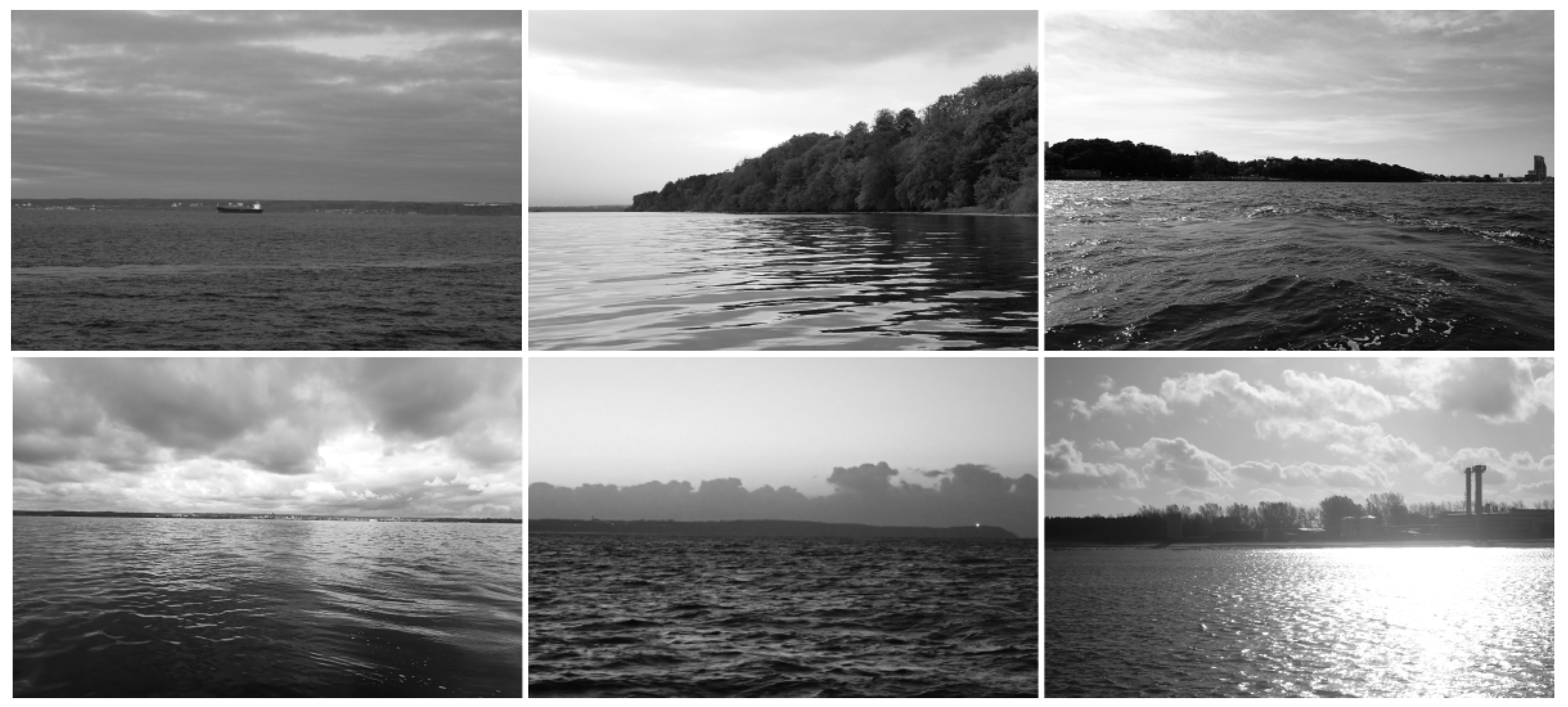
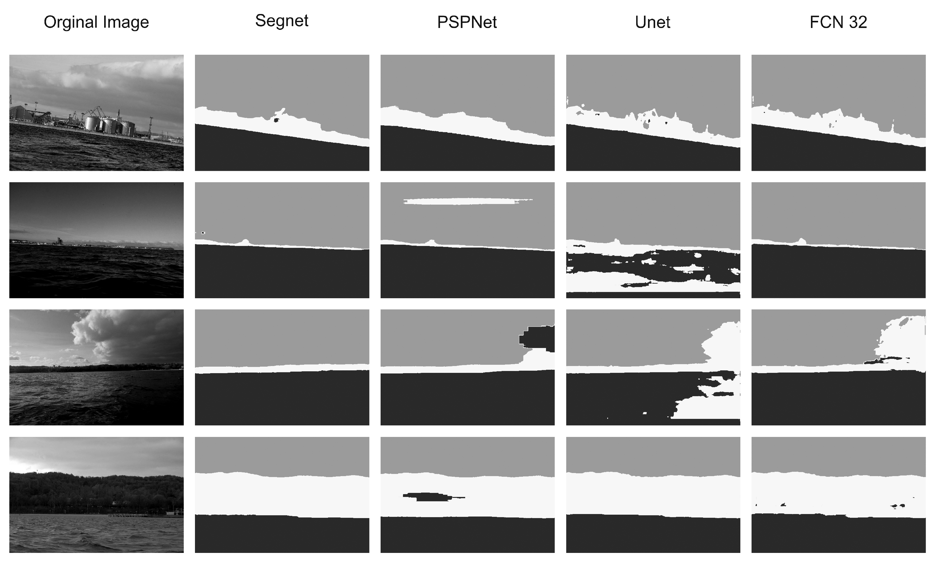
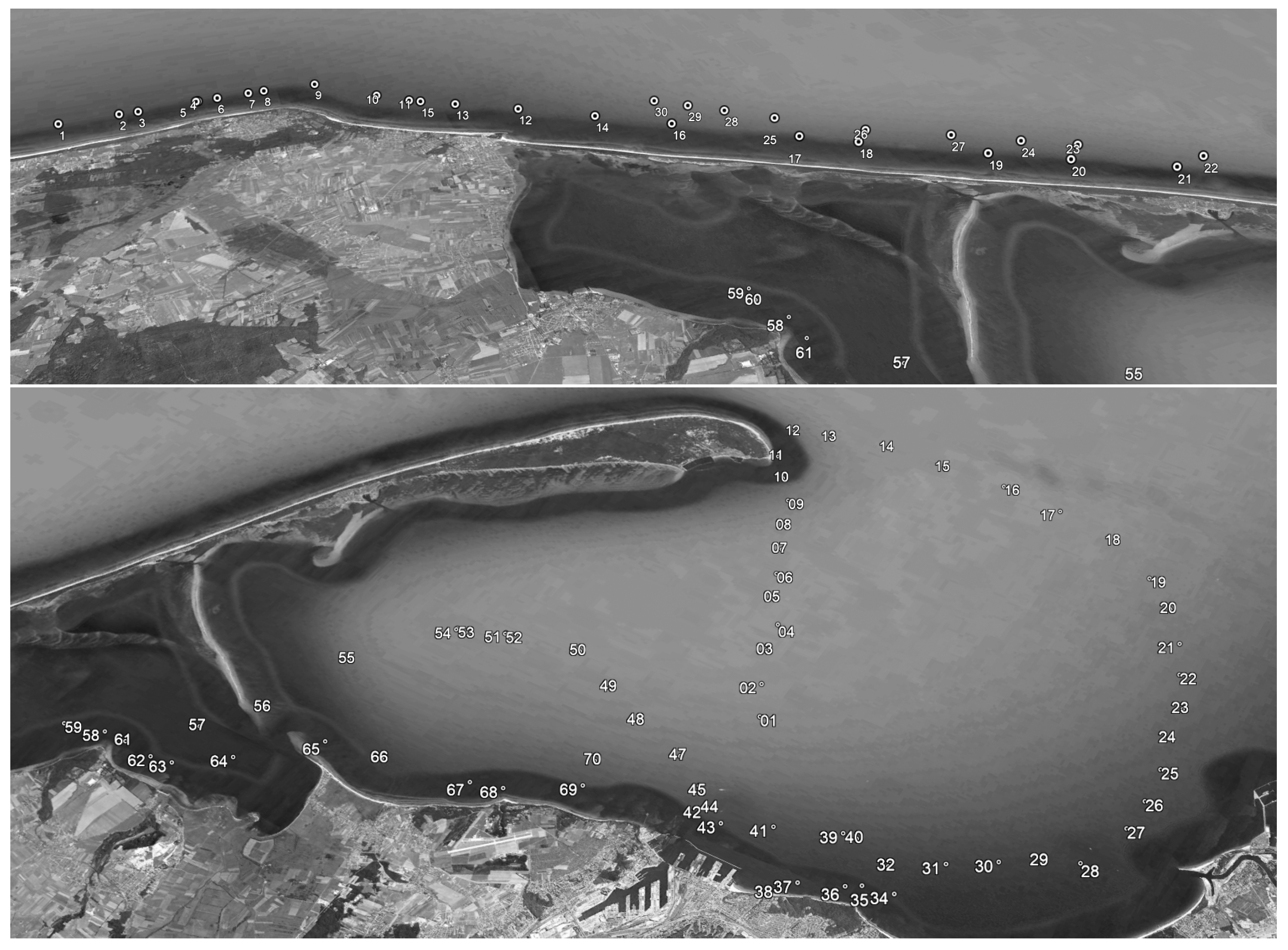
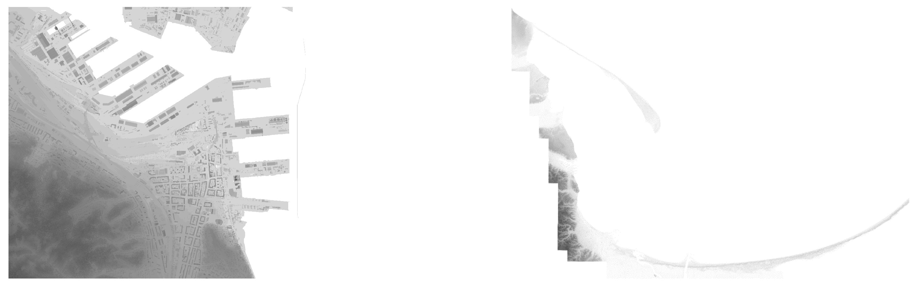
| Model | Training Loss | Training Accuracy | Validation Loss | Validation Accuracy |
|---|---|---|---|---|
| FCN-32 | 1.0985 | 0.3398 | 1.0984 | 0.3431 |
| PSPNet | 0.1685 | 0.9480 | 0.6678 | 0.8120 |
| Unet | 0.1355 | 0.9595 | 0.3672 | 0.8847 |
| Segnet | 0.0614 | 0.9802 | 0.0833 | 0.9694 |
| Error | Min [m] | Max [m] | Average [m] |
|---|---|---|---|
| Euclidean | 10.43 | 189.25 | 91.62 |
| Correlation | 8.93 | 102.40 | 64.60 |
| Error | Min [m] | Max [m] | Average [m] |
|---|---|---|---|
| 1 point | 8.93 | 102.40 | 64.60 |
| 5 points | 4.37 | 64.59 | 34.78 |
Disclaimer/Publisher’s Note: The statements, opinions and data contained in all publications are solely those of the individual author(s) and contributor(s) and not of MDPI and/or the editor(s). MDPI and/or the editor(s) disclaim responsibility for any injury to people or property resulting from any ideas, methods, instructions or products referred to in the content. |
© 2024 by the authors. Licensee MDPI, Basel, Switzerland. This article is an open access article distributed under the terms and conditions of the Creative Commons Attribution (CC BY) license (https://creativecommons.org/licenses/by/4.0/).
Share and Cite
Zalewski, J.; Hożyń, S. Computer Vision-Based Position Estimation for an Autonomous Underwater Vehicle. Remote Sens. 2024, 16, 741. https://doi.org/10.3390/rs16050741
Zalewski J, Hożyń S. Computer Vision-Based Position Estimation for an Autonomous Underwater Vehicle. Remote Sensing. 2024; 16(5):741. https://doi.org/10.3390/rs16050741
Chicago/Turabian StyleZalewski, Jacek, and Stanisław Hożyń. 2024. "Computer Vision-Based Position Estimation for an Autonomous Underwater Vehicle" Remote Sensing 16, no. 5: 741. https://doi.org/10.3390/rs16050741
APA StyleZalewski, J., & Hożyń, S. (2024). Computer Vision-Based Position Estimation for an Autonomous Underwater Vehicle. Remote Sensing, 16(5), 741. https://doi.org/10.3390/rs16050741