Risk Assessment of Geological Landslide Hazards Using D-InSAR and Remote Sensing
Abstract
1. Introduction
2. Study Area and Data
2.1. Study Area
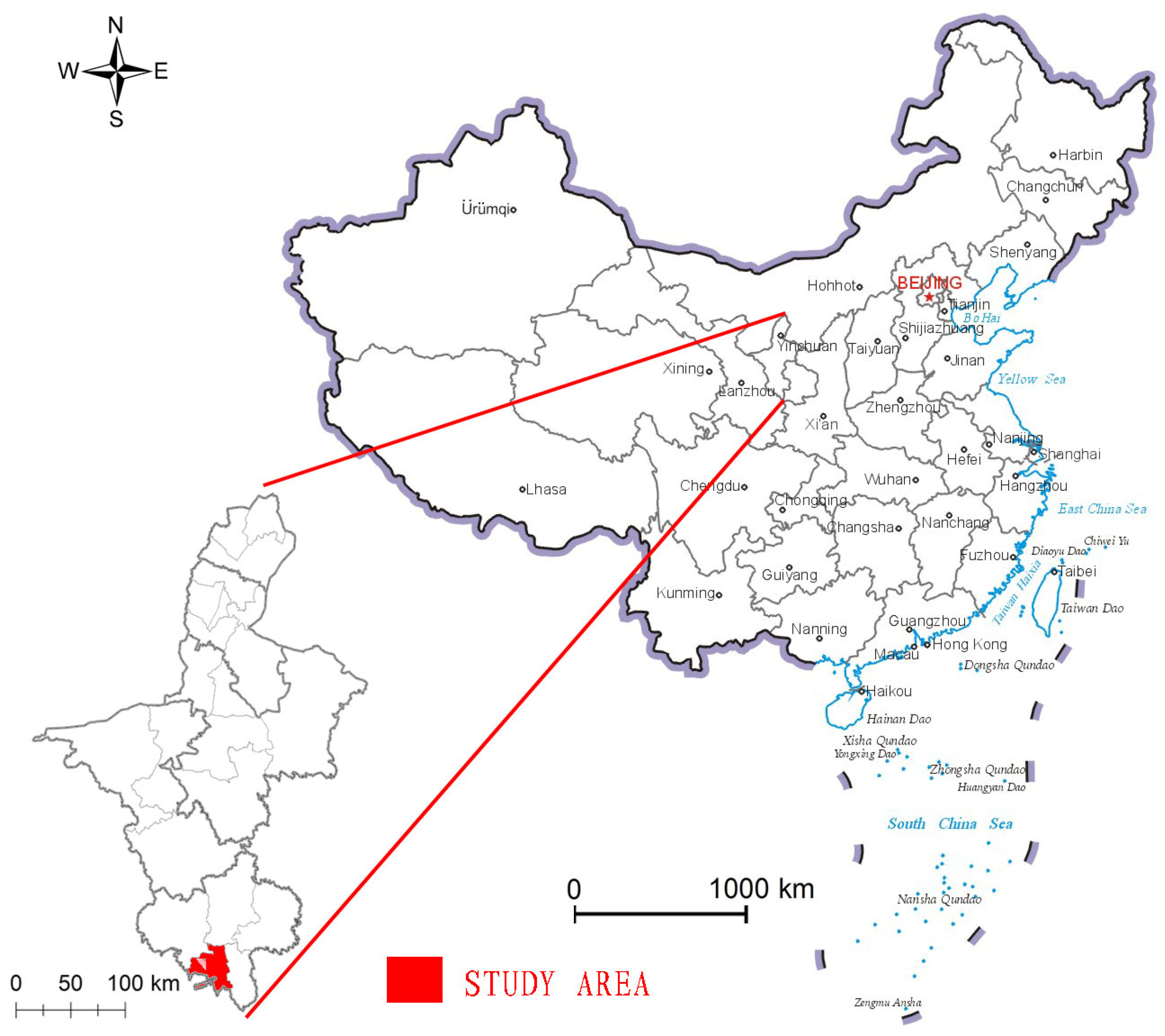
2.2. Data Source and Preprocessing
3. Methods
3.1. Acquisition of Surface Deformation
3.2. Integrated Remote Sensing Interpretation
4. Identification of Landslide Hazards
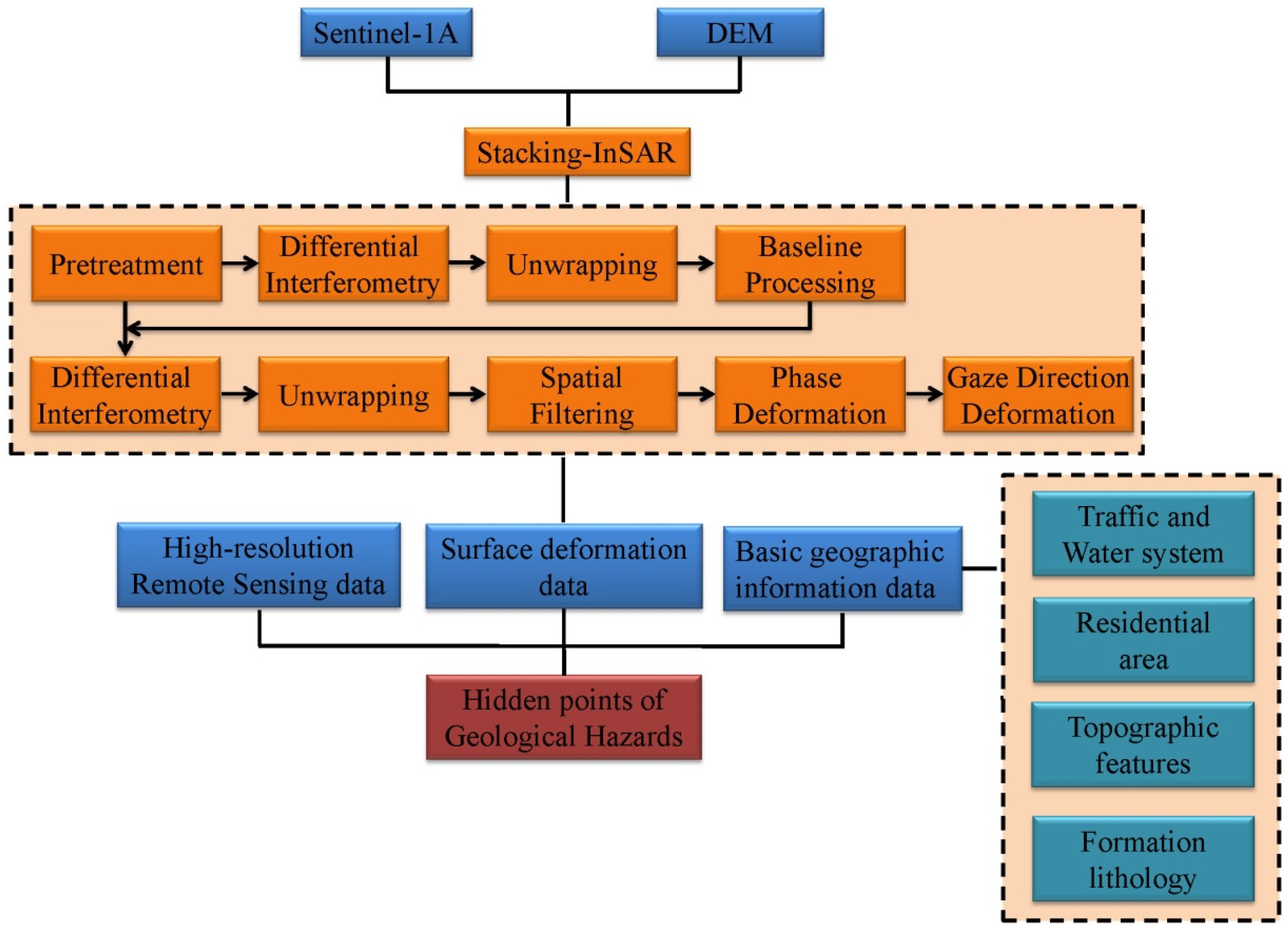
4.1. Stacking-InSAR Deformation Detection Technology
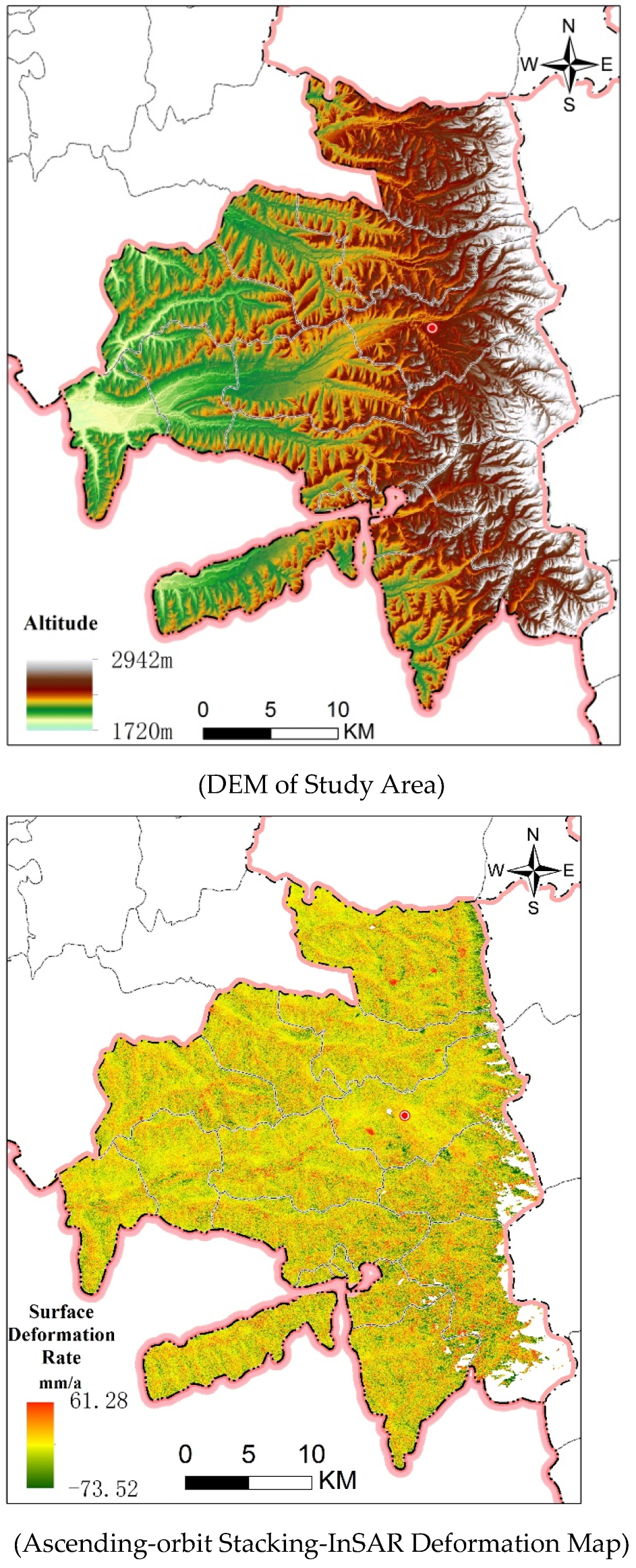
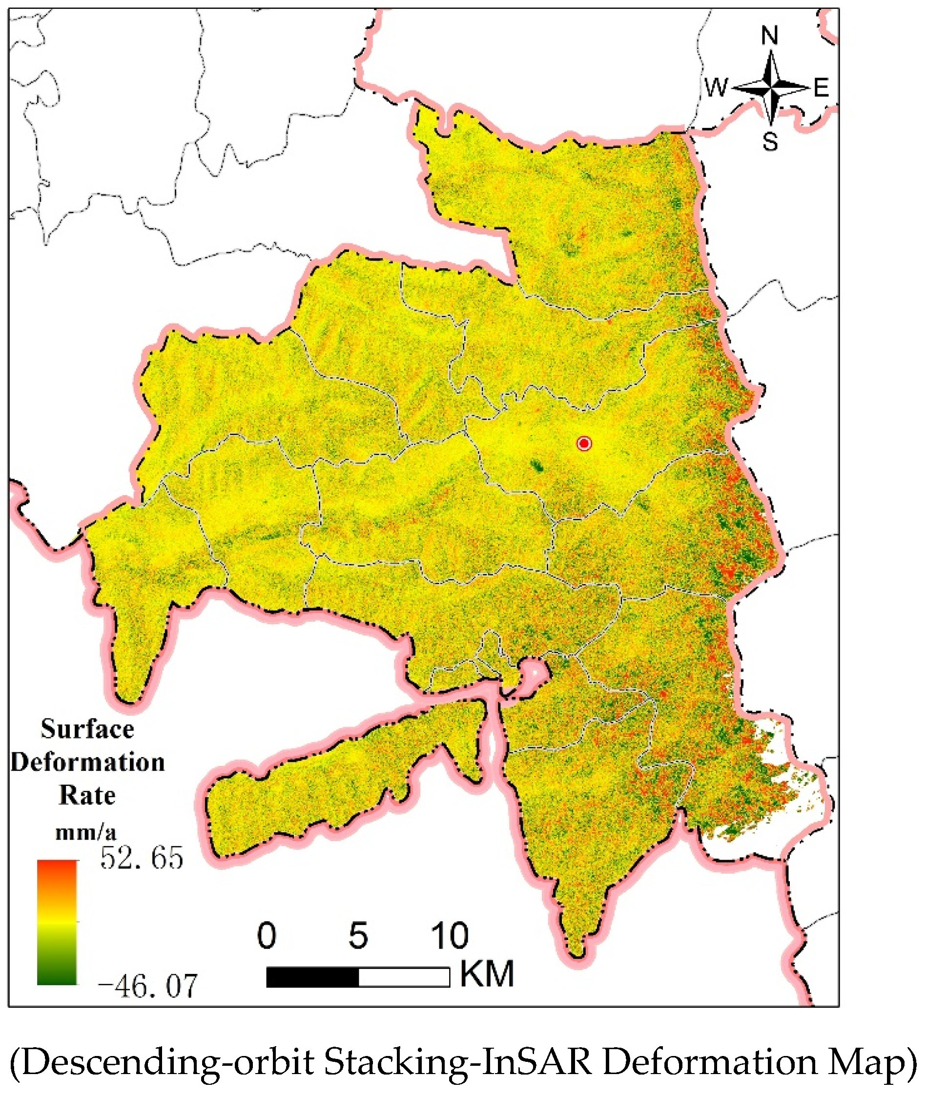
4.2. InSAR Deformation Recognition Results
4.3. Integrated Remote Sensing Identification of Landslide Hazards

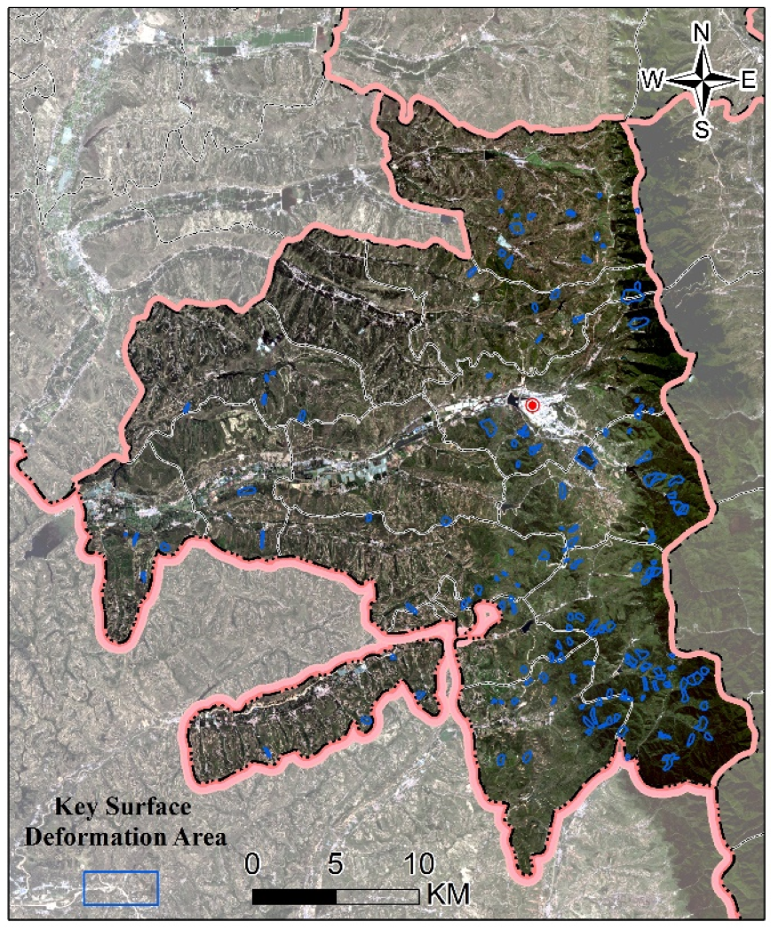
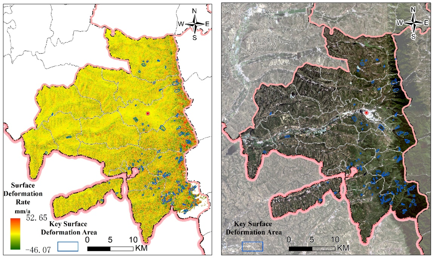
5. Discussion
5.1. Remote Sensing Characteristics Analysis of Typical Landslide Hazards
5.1.1. The Hidden Danger Points of Shenlin Village Landslide
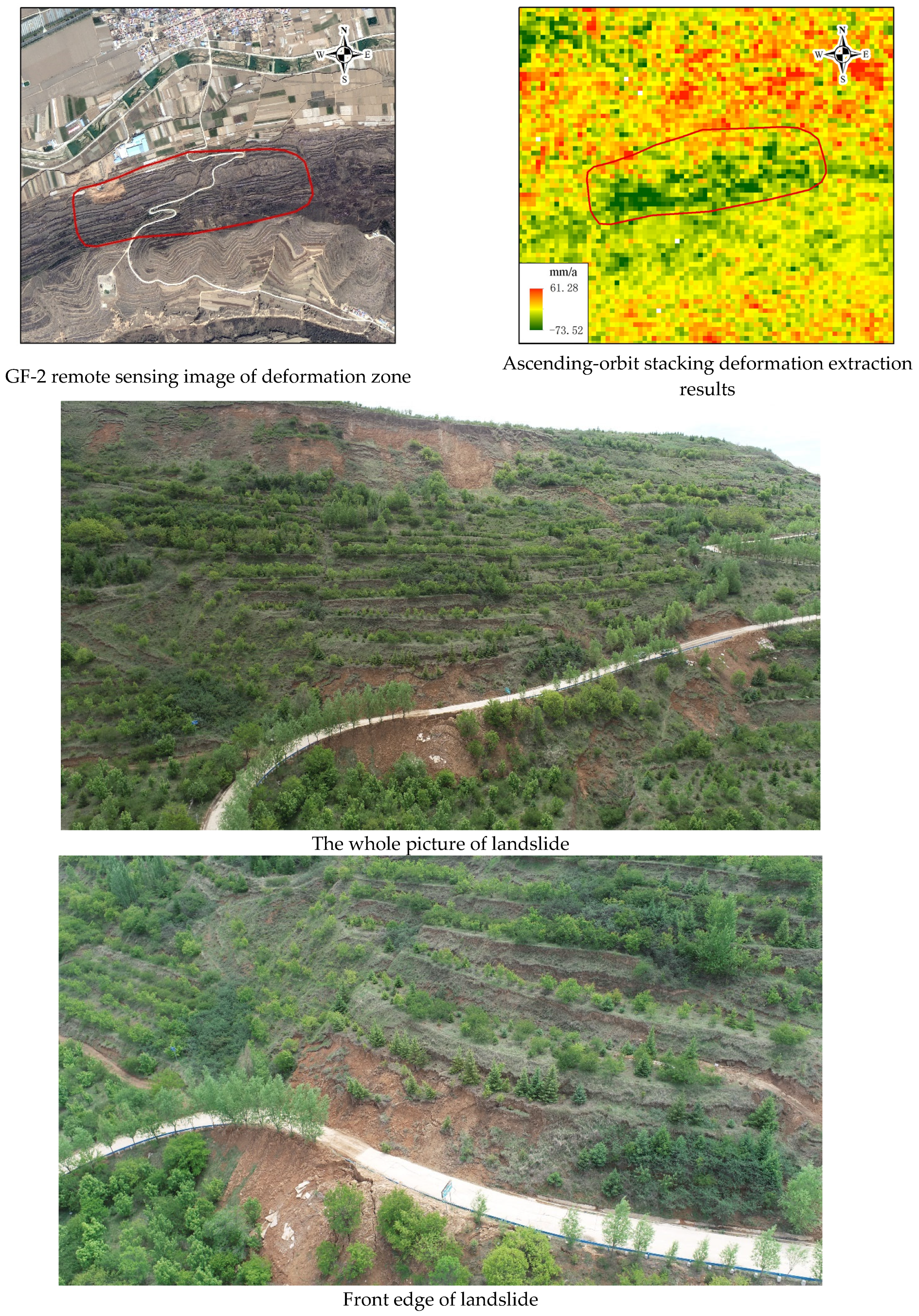
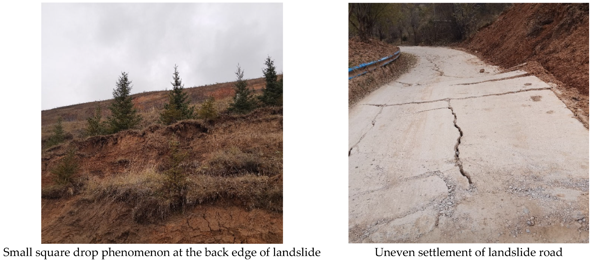
5.1.2. The Hidden Danger Points of Shenlin Village Landslide
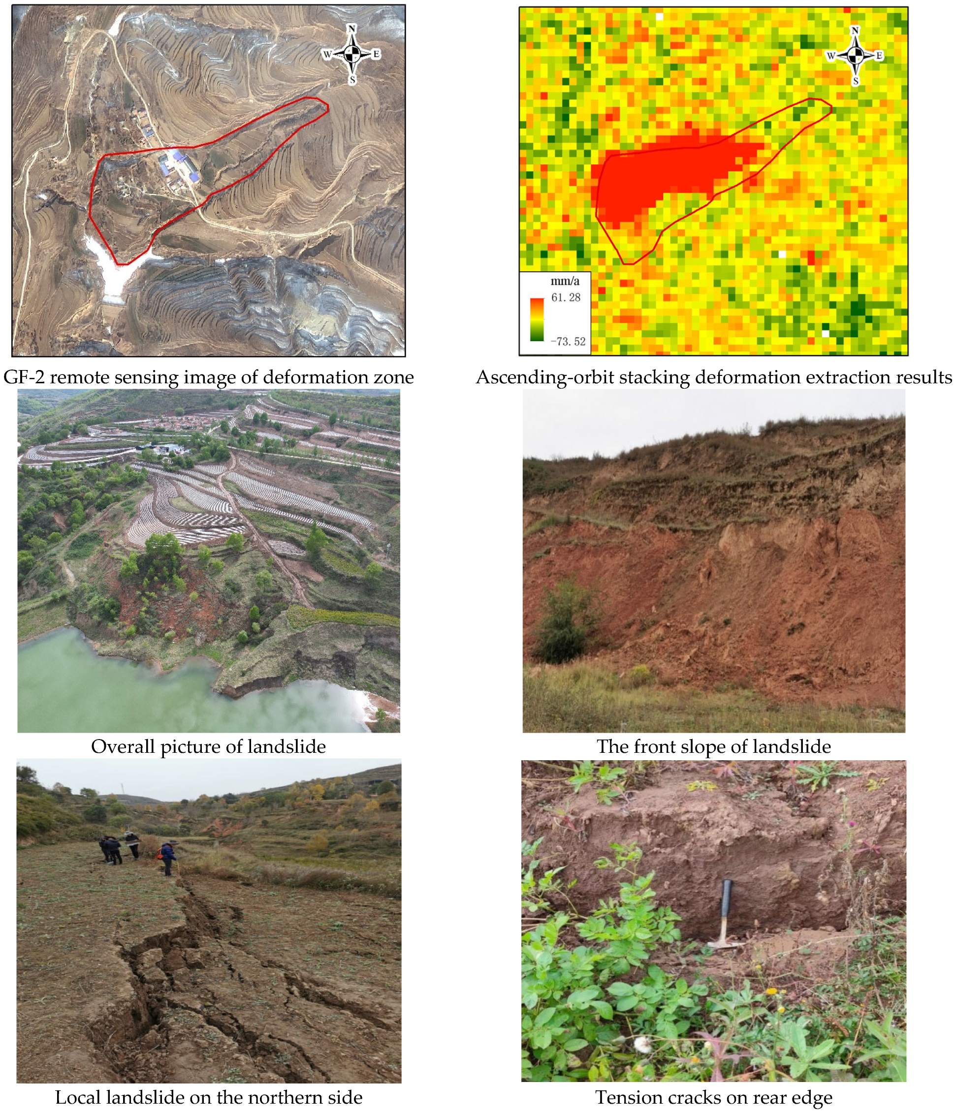
5.2. Future Research
5.2.1. Importance and Innovation of Technical Approaches
5.2.2. Technical Limitations and Future Research Directions
- ➢
- InSAR technology uses the principle of electromagnetic wave phase coherence to calculate the surface deformation, but the dense vegetation cover and rapid large deformation (abrupt landslide) will make the two kinds of monitoring data before and after the deformation lose coherence, rendering the deformation monitoring ability invalid;
- ➢
- InSAR technology will inevitably be affected by vegetation, topography, atmosphere, etc., resulting in a reduction in information extraction accuracy for the surface deformation, making it unable to obtain more comprehensive identification of landslide hazards;
- ➢
- Due to the limitation of satellite resolution, satellite remote sensing is only suitable for target observation with a large area. For those small geological hazards discovered by manual investigation, especially those with small plane projection areas, the identification ability will be lost. The spatial resolution of the radar data used in this study is 20 m, which means that only a few pixels constitute the landslide body (within 9 pixels, approximately 60 m by 60 m in the field). Due to the limited number of pixels and the presence of noise in the remote sensing data, it is difficult to distinguish and identify these landslides. Additionally, some landslides with very small angles between the mountain slope and the radar scanning angle are also challenging to identify.
- ➢
- In terms of the loess hilly region in southern Ningxia, the scale of geological hazards in southern Ningxia is not the same, due to the differences in the development degree and terrain cutting degree of loess micromorphology such as loess ridges and loess residual tableland. Therefore, it is necessary to study the “zoning classification” of remote-sensing-integrated identification technology of geological hazards in combination with the stage of landform development, the mode, and the scale of geological hazards. It also becomes incumbent to adopt ideas of combining different-spatial-resolution (meter-level, sub-meter-level) remote sensing data and combining different remote sensing platforms (satellites, unmanned aerial vehicles) to identify different scales of geological hazards in various districts and counties in southern Ningxia. This will help to realize the full identification coverage of work area geological hazards (all levels of scale);
- ➢
- In addition to Stacking-InSAR, for technologies such as D-InSAR, PS-InSAR, and SBAS-InSAR, the application effect and conditions of various InSAR techniques in surface deformation identification in the loess hilly area of southern Ningxia should also be further experimented and verified to reveal the optimal solution of different InSAR technology algorithms and different SAR data track, time image, and resolution selection (loess hilly area of southern Ningxia);
- ➢
- The landslide hazard points identified by the integrated remote sensing technology also need the geological personnel to arrive at the site for investigation and review one by one to identify, confirm, or eliminate the hazard points. Sometimes, it is necessary to use field observation and detection methods for accurate determination. Moreover, the geological disaster points in the loess hilly area in southern Ningxia are wide and part of the small-scale but dangerous geological hazards that could be easily missed under technical means, meaning that artificial investigation and mass observation and preparedness are still essential and very important means of work.
6. Conclusions
Author Contributions
Funding
Institutional Review Board Statement
Informed Consent Statement
Data Availability Statement
Conflicts of Interest
References
- Au, S.W.C. Rain-induced slope instability in Hong Kong. Eng. Geol. 1998, 51, 1–36. [Google Scholar] [CrossRef]
- Schuster, R.L.; Lynn, M.H. Socioeconomic Impacts of Landslides in the Western Hemisphere; United States Geological Survey: Reston, VA, USA, 2001. [Google Scholar]
- Yamagishi, H. Recent landslides in Western Hokkaido, Japan. Pure Appl. Geophys. 2000, 157, 1115–1134. [Google Scholar] [CrossRef]
- Lin, P.S.; Lin, J.Y.; Hung, J.C.; Yang, M.D. Assessing debris-flow hazard in a watershed in Taiwan. Eng. Geol. 2002, 66, 295–313. [Google Scholar] [CrossRef]
- Bhasin, R.; Grimstad, E.; Larsen, J.O.; Dhawan, A.K.; Singh, R.; Verma, S.; Venkatachalam, K. Landslide hazards and mitigation measures at Gangtok, Sikkim Himalaya. Eng. Geol. 2002, 64, 351–368. [Google Scholar] [CrossRef]
- Xu, Q.; Dong, X.; Li, W. Integrated Space-Air-Ground Early Detection, Monitoring and Warning System for Portential Catastrophic Geohazards. Geomat. Inf. Sci. Wuhan Univ. 2019, 44, 957–966. [Google Scholar]
- Xu, Q. Understanding and Consideration of Related Issues in Early Identification of Potential Geohazards. Geomat. Inf. Sci. Wuhan Univ. 2020, 45, 1651–1659. [Google Scholar]
- Ge, D. Application of Remote Sensing in Early Recognition and Monitoring and Early Warning of Geological Hazards. City Disater Reduct. 2018, 06, 53–60. [Google Scholar]
- Ge, D.; Dai, K.; Guo, Z.; Li, Z. Early Identification of Serious Geological Hazards with Integrated Remote Sensing Technologies: Thoughts and Recommendations. Geomat. Inf. Sci. Wuhan Univ. 2019, 44, 949–956. [Google Scholar]
- Ge, D.; Guo, Z. Thoughts of Early Identification of Serious Geological Hazards with Integrated Remote Sensing Technologies. China Emerg. Rescue 2019, 01, 10–14. [Google Scholar]
- Gao, L.Y.; Yu, J.K.; Zhang, Y.Y.; Cheng, J. Application of GIS-based Analytic Hierarchy Process in Geological Hazards Assessment in Ningxia Region. J. Inst. Disaster Prev. 2017, 19, 8–15. [Google Scholar]
- Wang, C.; Meng, F.; Li, T. Regional Geology of the Ningxia Hui Autonomous Region; Geology Survey Institute of Ningxia: Yinchuan, China, 2013; pp. 23–30. (In Chinese) [Google Scholar]
- Wang, X.; Fan, X.; Yang, F.; Dong, X. Remote Sensing Interpretation Method of Geological Hazards in Lush Mountainous Area. Geomat. Inf. Sci. Wuhan Univ. 2020, 45, 1771–1781. [Google Scholar]
- Zhang, Y.; Yu, J.; Bu, F.; Gao, L. Application of GF-2 Satellite to Geological Hazard Interpretation in Loess Plateau. Geomat. Spat. Inf. Technol. 2017, 40, 31–38. [Google Scholar]
- Peng, L.; Xu, S.N.; Mei, J.J.; Su, F.H. Earthquake-induced landslide recognition using high-resolution remote sensing images. J. Remote Sens. 2017, 21, 509–518. [Google Scholar] [CrossRef]
- Haque, U.; Blum, P.; da Silva, P.F.; Andersen, P.; Pilz, J.; Chalov, S.R.; Malet, J.-P.; Auflič, M.J.; Andres, N.; Poyiadji, E.; et al. Fatal landslides in Europe. Landslides 2016, 13, 1545–1554. [Google Scholar] [CrossRef]
- Carlà, T.; Intrieri, E.; Raspini, F.; Bardi, F.; Farina, P.; Ferretti, A.; Colombo, D.; Novali, F.; Casagli, N. Perspectives on the prediction of catastrophic slope failures from satellite InSAR. Sci. Rep. 2019, 9, 14137. [Google Scholar] [CrossRef] [PubMed]
- Shimin LY, U.; Kai, W.U.; Guangbo, D.U. Development Characteristics and Formation Conditions of Geological Hazards in Longde County of Ningxia. J. Water Resour. Archit. Eng. 2015, 13, 42–47. [Google Scholar]
- Zebker, H.A.; Rosen, P.A. Atmospheric Artifacts in Interferometric SAR Surface Deformation and Topographic Maps; Department of Electrical Engineering and Geophysics, University of Stanford: Stanford, CA, USA, 1996. [Google Scholar]
- Ferretti, A.; Prati, C.; Rocca, F. Permanent Scatterers in SAR Interferometry. IEEE Trans. Geosci. Remote Sens. 2001, 39, 8–20. [Google Scholar] [CrossRef]
- Colesanti, C.; Ferretti, A.; Novali, F.; Prati, C.; Rocca, F. Sar monitoring of progressive and seasonal ground deformation using the permanent scatterers technique. IEEE Trans. Geosci. Remote Sens. 2003, 41, 1685–1701. [Google Scholar] [CrossRef]
- Ferretti, A.; Prati, C.; Rocca, F. Nonlinear subsidence rate estimation using permanent scatterers in differential SAR interferometry. IEEE Trans. Geosci. Remote Sens. 2000, 38, 2202–2212. [Google Scholar] [CrossRef]
- Lanari, R.; Mora, O.; Manunta, M.; Mallorqui, J.; Berardino, P.; Sansosti, E. A Small-Baseline Approach for Investigating Deformations on Full-Resolution Differential SAR Interferograms. IEEE Trans. Geosci. Remote Sens. 2004, 42, 1377–1386. [Google Scholar] [CrossRef]
- Werner, C.; Wegmuller, U.; Strozzi, T.; Wiesmann, A. Interferometric Point Target Analysis for Deformation Mapping. In Proceedings of the IGARSS 2003: 2003 IEEE International Geoscience and Remote Sensing Symposium, Toulouse, France, 21–25 July 2003; Proceedings (IEEE Cat. No.03CH37477). IEEE: Piscataway, NJ, USA, 2004. [Google Scholar]
- Ferretti, A.; Fumagalli, A.; Novali, F.; Prati, C.; Rocca, F.; Rucci, A. A New Algorithm for Processing Interferometric Data-Stacks: SqueeSAR. IEEE Trans. Geosci. Remote Sens. 2011, 49, 3460–3470. [Google Scholar] [CrossRef]
- Li, Z.; Song, C.; Yu, C.; Xiao, R.; Chen, L.; Luo, H. Application of Satellite Remote Sensing to Landslide Detection and Mornitoring: Challenges and Solutions. Geomat. Inf. Sci. Wuhan Univ. 2019, 44, 967–979. [Google Scholar]
- Fruneau, B.; Achache, J.; Delacourt, C. Observation and modelling of the Saint-ktienne-de-Tin&e landslide using SAR interferometry. Ectonophysics 1996, 265, 181–190. [Google Scholar]
- Raucoules, D.; Maisons, C.; Carnec, C.; Le Mouelic, S.; King, C.; Hosford, S. Monitoring of slow ground deformation by ERS radar interferometry on the Vauvert salt mine (France). Remote Sens. Environ. 2003, 88, 468–478. [Google Scholar] [CrossRef]
- Ling, P.; Suning, X.; Junjun, M.; Wenjuan, L. Research on Wenchuan Earthquake-induced Landslides Rapid Recognition from ZY-3 Imagery. Remote Sens. Technol. Appl. 2018, 33, 185–192. [Google Scholar]
- Cascini, L.; Fornaro, G.; Peduto, D. Advanced low- and full-resolution DInSAR map generation for slow-moving landslide analysis at different scales. Eng. Geol. 2010, 112, 29–42. [Google Scholar] [CrossRef]
- Strozzi, T.; Wegmuller, U.; Werner, C.; Wiesmann, A. Measurement of slow uniform surface displacement with mm/year accuracy. In Proceedings of the IGARSS 2000: IEEE 2000 International Geoscience and Remote Sensing Symposium, Honolulu, HI, USA, 24–28 July 2000; Volume 686. [Google Scholar]
- Luo, P.; Yan, P.; Wang, X.; Wu, Y.; Lyu, J.; He, B.; Duan, W.; Wang, S.; Zha, X. Historical and comparative overview of sponge campus construction and future challenges. Sci. Total Environ. 2024, 907, 167477. [Google Scholar] [CrossRef]
- Xie, D.; Duan, L.; Si, G.; Liu, W.; Zhang, T.; Mulder, J. Long-Term 15N Balance After Single-Dose Input of 15N-Labeled NH4+ and NO3− in a Subtropical Forest Under Reducing N Deposition. Glob. Biogeochem. Cycles 2021, 35, e2021GB006959. [Google Scholar] [CrossRef]
- Liu, X.; Zhao, C.; Zhang, Q.; Lu, Z.; Li, Z.; Yang, C.; Zhu, W.; Liu, Z.; Chen, L.; Liu, C. Integration of Sentinel-1 and ALOS/PALSAR-2 SAR datasets for mapping active landslides along the Jinsha River corridor, China. Eng. Geol. 2021, 284, 106033. [Google Scholar] [CrossRef]
- Wu, X.; Fang, G.; Xue, G.; Liu, L.; Liu, L.; Li, J. The Development and Applications of the Helicopter-borne Transient Electromagnetic System CAS-HTEM. J. Environ. Eng. Geophys. 2019, 24, 653–663. [Google Scholar] [CrossRef]
- Langhammer, L.; Rabenstein, L.; Schmid, L.; Bauder, A.; Grab, M.; Schaer, P.; Maurer, H. Glacier bed surveying with helicopter-borne dual-polarization ground-penetrating radar. J. Glaciol. 2018, 65, 123–135. [Google Scholar] [CrossRef]
- Luo, P.; Wang, X.; Zhang, L.; Mohd Arif Zainol, M.R.R.; Duan, W.; Hu, M.; Guo, B.; Zhang, Y.; Wang, Y.; Nover, D. Future Land Use and Flood Risk Assessment in the Guanzhong Plain, China: Scenario Analysis and the Impact of Climate Change. Remote Sens. 2023, 15, 5778. [Google Scholar] [CrossRef]
- Zhu, W.; Wang, S.; Luo, P.; Zha, X.; Cao, Z.; Lyu, J.; Zhou, M.; He, B.; Nover, D. A Quantitative Analysis of the Influence of Temperature Change on the Extreme Precipitation. Atmosphere 2022, 13, 612. [Google Scholar] [CrossRef]
- Huo, A.; Peng, J.; Cheng, Y.; Luo, P.; Zhao, Z.; Zheng, C. Hydrological Analysis of Loess Plateau Highland Control Schemes in Dongzhi Plateau. Front. Earth Sci. 2020, 8, 637. [Google Scholar] [CrossRef]
- Duan, W.; Zou, S.; Christidis, N.; Schaller, N.; Chen, Y.; Sahu, N.; Li, Z.; Fang, G.; Zhou, B. Changes in temporal inequality of precipitation extremes over China due to anthropogenic forcings. NPJ Clim. Atmos. Sci. 2022, 5, 1–13. [Google Scholar] [CrossRef]
- Duan, W.; Maskey, S.; Chaffe, P.L.; Luo, P.; He, B.; Wu, Y.; Hou, J. Recent advancement in remote sensing technology for hydrology analysis and water resources management. Remote Sens. 2021, 13, 1097. [Google Scholar] [CrossRef]
- Cao, Z.; Zhu, W.; Luo, P.; Wang, S.; Tang, Z.; Zhang, Y.; Guo, B. Spatially Non-Stationary Relationships between Changing Environment and Water Yield Services in Watersheds of China’s Climate Transition Zones. Remote Sens. 2022, 14, 5078. [Google Scholar] [CrossRef]
- Wang, Z.; Luo, P.; Zha, X.; Xu, C.; Kang, S.; Zhou, M.; Nover, D.; Wang, Y. Overview assessment of risk evaluation and treatment technologies for heavy metal pollution of water and soil. J. Clean. Prod. 2022, 379, 134043. [Google Scholar] [CrossRef]
- Ali, R.; Alban, K.; Ozgur, K. Human–environment natural disasters interconnection in China: A review. Climate 2020, 8, 48. [Google Scholar] [CrossRef]
- Han, W.; Liang, C.; Jiang, B.; Ma, W.; Zhang, Y. Major Natural Disasters in China, 1985–2014: Occurrence and Damages. Int. J. Environ. Res. Public Health 2016, 13, 1118. [Google Scholar] [CrossRef]
- Liu, Y.; Yang, H.; Wang, S.; Xu, L.; Peng, J. Monitoring and Stability Analysis of the Deformation in the Woda Landslide Area in Tibet, China by the DS-InSAR Method. Remote Sens. 2022, 14, 532. [Google Scholar] [CrossRef]
- Zhang, Y.; Meng, X.; Jordan, C.; Novellino, A.; Dijkstra, T.; Chen, G. Investigating slow-moving landslides in the Zhouqu region of China using InSAR time series. Landslides 2018, 15, 1299–1315. [Google Scholar] [CrossRef]
- Eriksen, H.; Lauknes, T.R.; Larsen, Y.; Corner, G.D.; Bergh, S.G.; Dehls, J.; Kierulf, H.P. Visualizing and interpreting surface displacement patterns on unstable slopes using multi-geometry satellite SAR interferometry (2D InSAR). Remote Sens. Environ. 2017, 191, 297–312. [Google Scholar] [CrossRef]
- Li, X.; Zhou, L.; Su, F.; Wu, W. Application of InSAR technology in landslide hazard: Progress and prospects. Natl. Remote Sens. Bull 2021, 25, 614–629. [Google Scholar] [CrossRef]
- Ma, S.; Qiu, H.; Yang, D.; Wang, J.; Zhu, Y.; Tang, B.; Sun Ki Cao, M. Surface multi-hazard effect of underground coal mining. Landslides 2022, 20, 39–52. [Google Scholar] [CrossRef]
- Liu, Z.; Qiu, H.; Zhu, Y.; Liu, Y.; Yang, D.; Ma, S.; Zhang, J.; Wang, Y.; Wang, L.; Tang, B. Efficient Identification and Monitoring of Landslides by Time-Series InSAR Combining Single- and Multi-Look Phases. Remote Sens. 2022, 14, 1026. [Google Scholar] [CrossRef]
- Wang, L.; Qiu, H.; Zhou, W.; Zhu, Y.; Liu, Z.; Ma, S.; Yang, D.; Tang, B. The post-failure spatiotemporal deformation of certain translational landslides may follow the pre-failure pattern. Remote Sens. 2022, 14, 2333. [Google Scholar] [CrossRef]

| Direct interpretation signs | It is shown as round-backed armchair, double ditch homologous, ellipse, strip, skip shape, tongue shape, arc shape, irregular polygon, etc. The upper slopes are gentler than the surrounding terrain but can be distinguished from erosion platforms and terraces. | |
| Indirect interpretation signs | Color | The landslide body has a light hue, and the trailing edge arc is linear and clear, which is significantly different from the surrounding deep-tone bedrock. |
| Topography | It is often distributed in the local depression area of steep slopes such as valleys and rivers or in the abnormal part of river channel migration. An arc anomaly image is developed at the back edge of the landslide body, including the steep slope, terrain variation line, and hue anomaly line. The front slope of the landslide protrudes to the valley, and there are often images of topographic microprotrusions and small landslide flow accumulation. | |
| Water system | A relatively independent and closed catchment area, with a water network system or structure inconsistent with the adjacent area, often leads to topographic variations such as the ones witnessed in modern water system changes. | |
| Number | Characteristics of Hidden Dangers | Disaster Interpretation Image | Disaster InSAR Image |
|---|---|---|---|
| 1 | Landslide, old landslide, InSAR results show that the whole landslide has deformation, the characteristics of the back wall and side wall of the landslide are obvious, the overall perimeter is clear, there are gullies on the surface of the slope, and houses and roads are distributed on the trailing edge. |  | 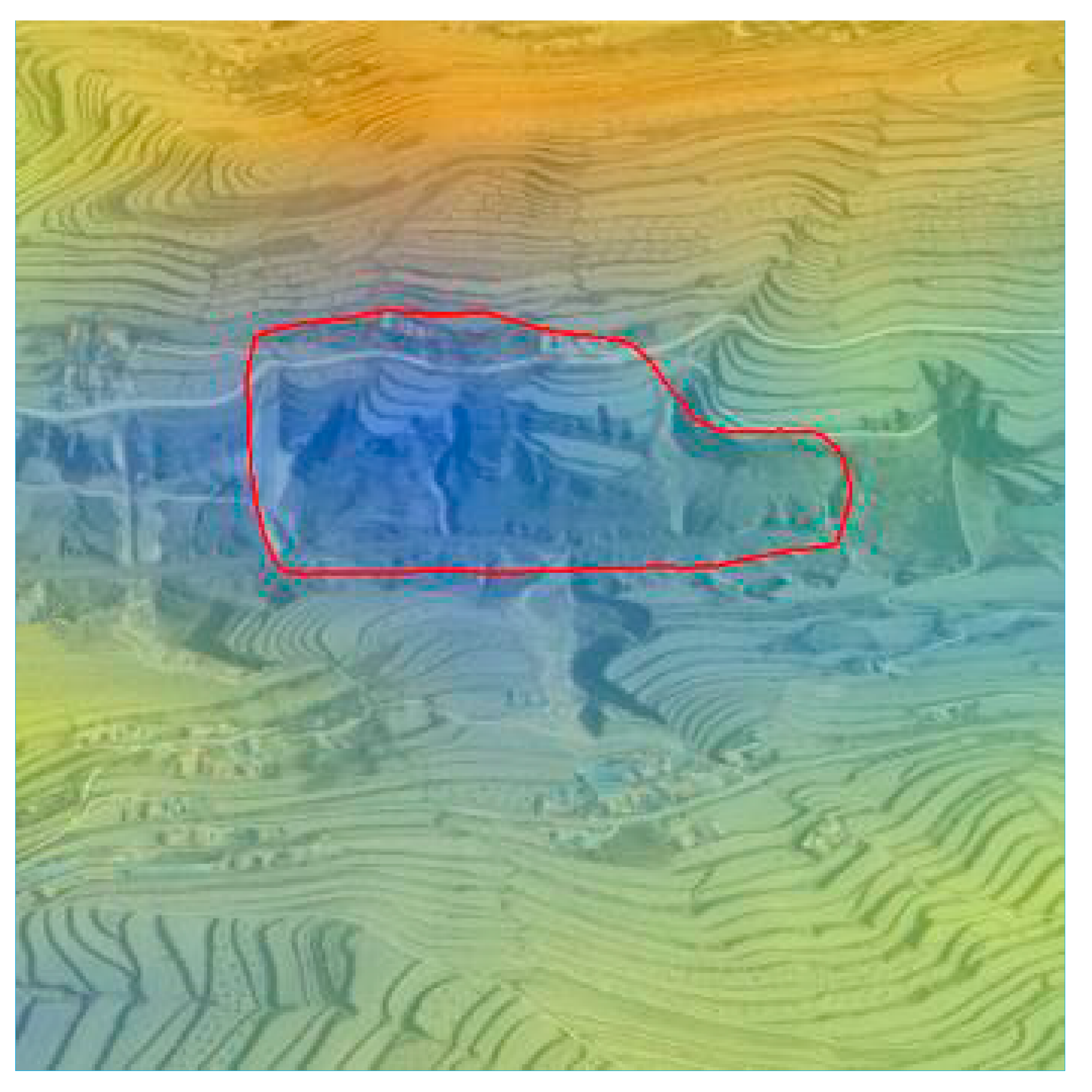 |
| 2 | Landslide, old landslide, InSAR results show that the trailing edge and the left wall have obvious deformation, the characteristics of the left wall of the landslide are obvious, the perimeter of the whole landslide is clear, and the front edge is distributed with roads and reservoirs. | 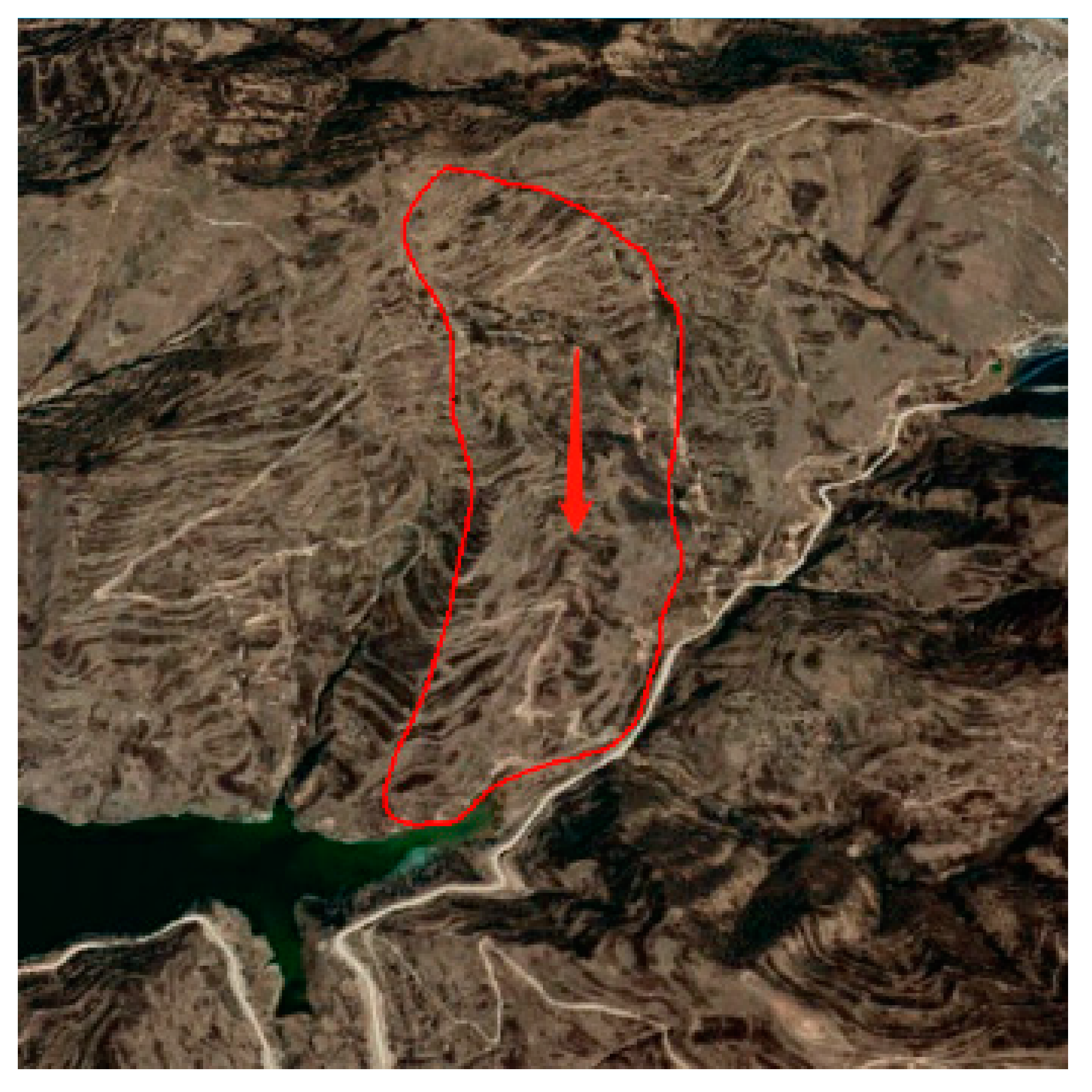 | 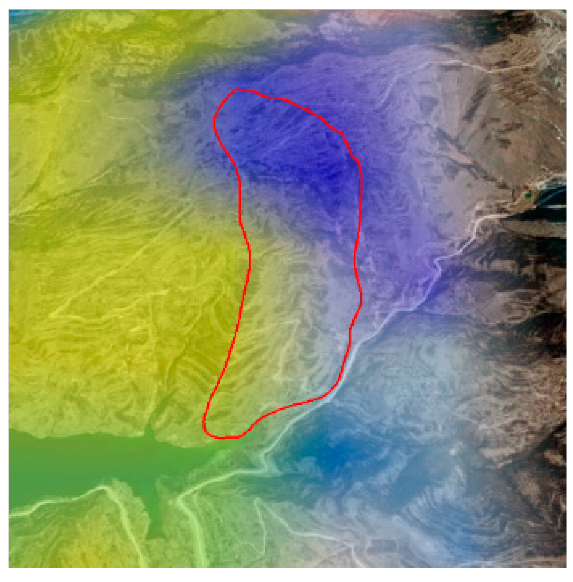 |
| 3 | Landslide, old landslide, InSAR results show that the front edge is deformed, the characteristics of the back wall and side wall of the landslide are obvious, the overall perimeter is clear, the back wall is steep, the front edge protrudes, there is debris flow on the slope surface, and the front edge is distributed in the factory building. | 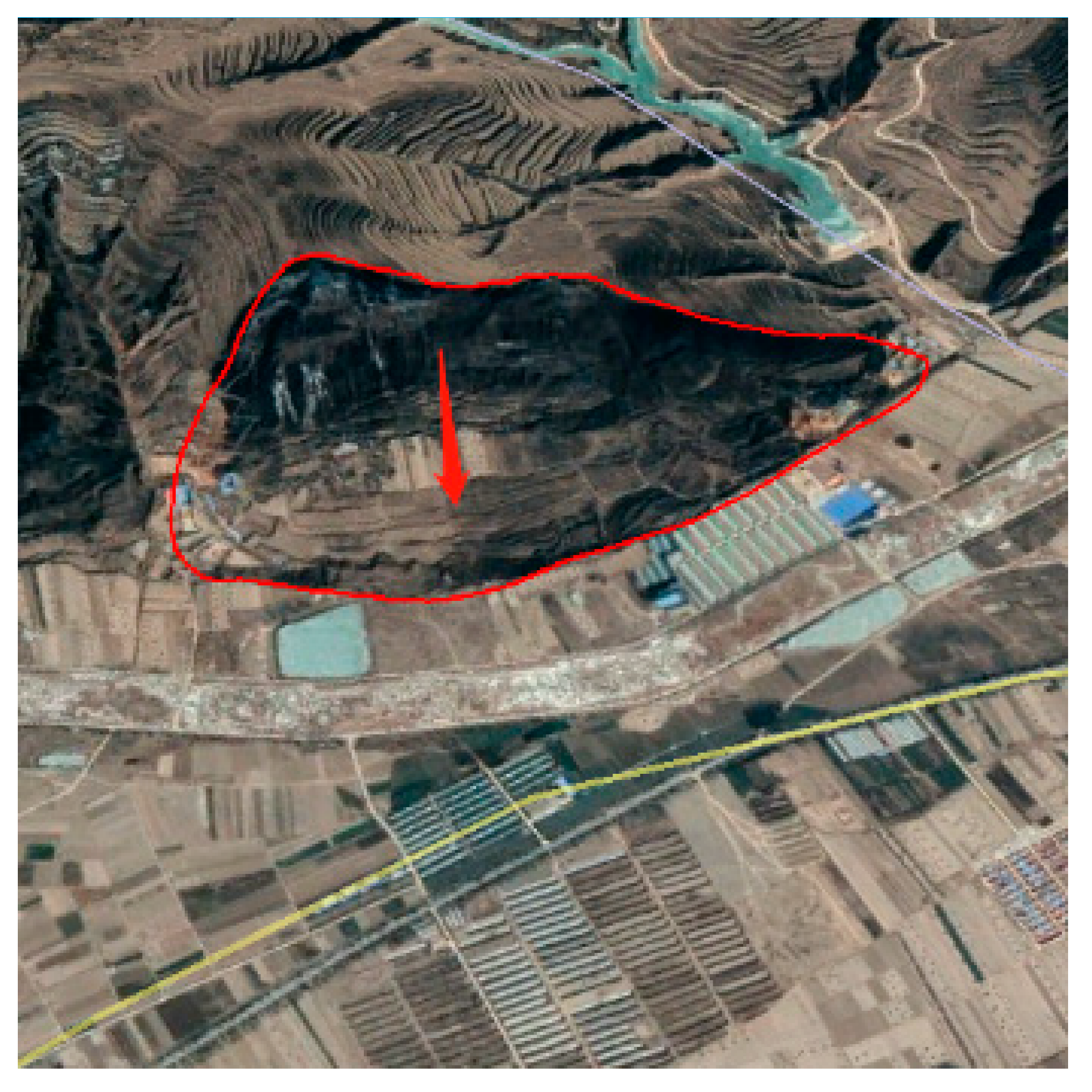 | 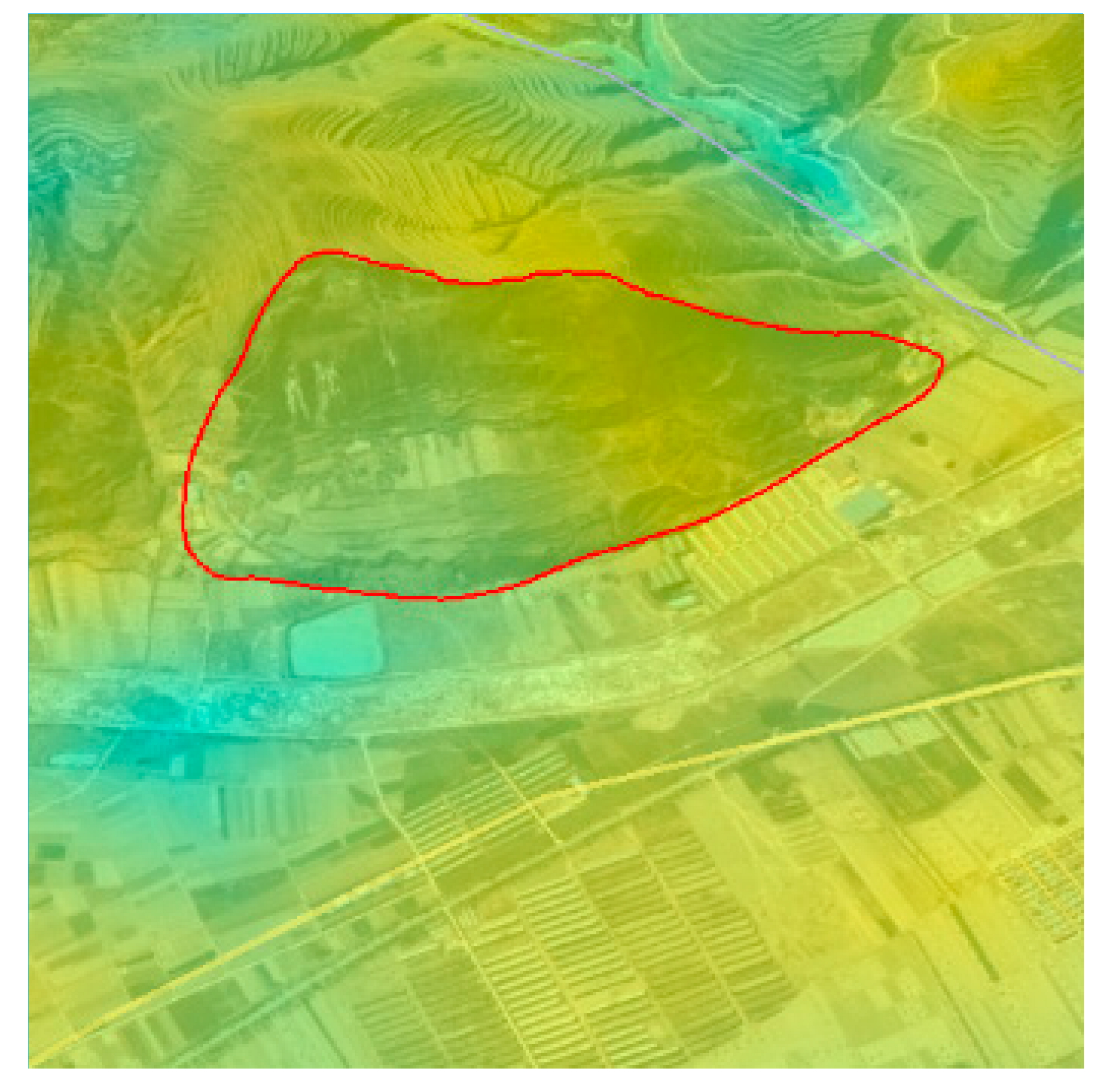 |
| 4 | Landslide, old landslide, InSAR results show that the front edge of the landslide has deformation, the characteristics of the landslide sidewall are obvious, the shape of the whole landslide can be seen, the front edge of the slope has accumulation, and there is a road passing through the middle. | 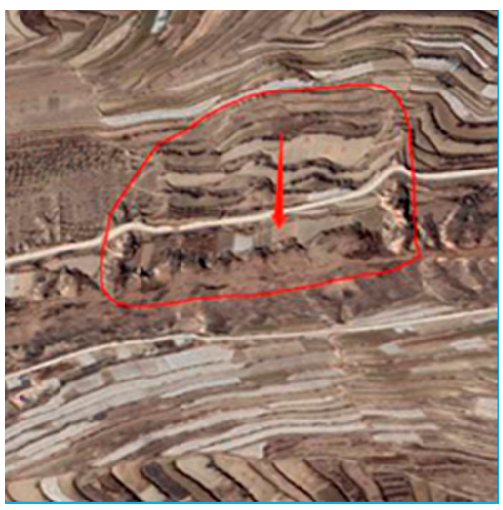 | 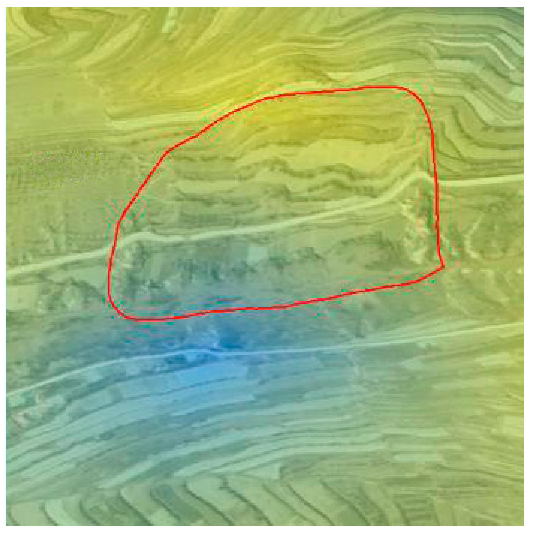 |
| 5 | Landslide, old landslide, InSAR results show that the front edge of the landslide has deformation, the characteristics of the back wall and side wall of the landslide are obvious, the overall perimeter is clear, there is a secondary landslide on the surface of the slope, the back edge is connected with the road, and the front edge is distributed with rivers. | 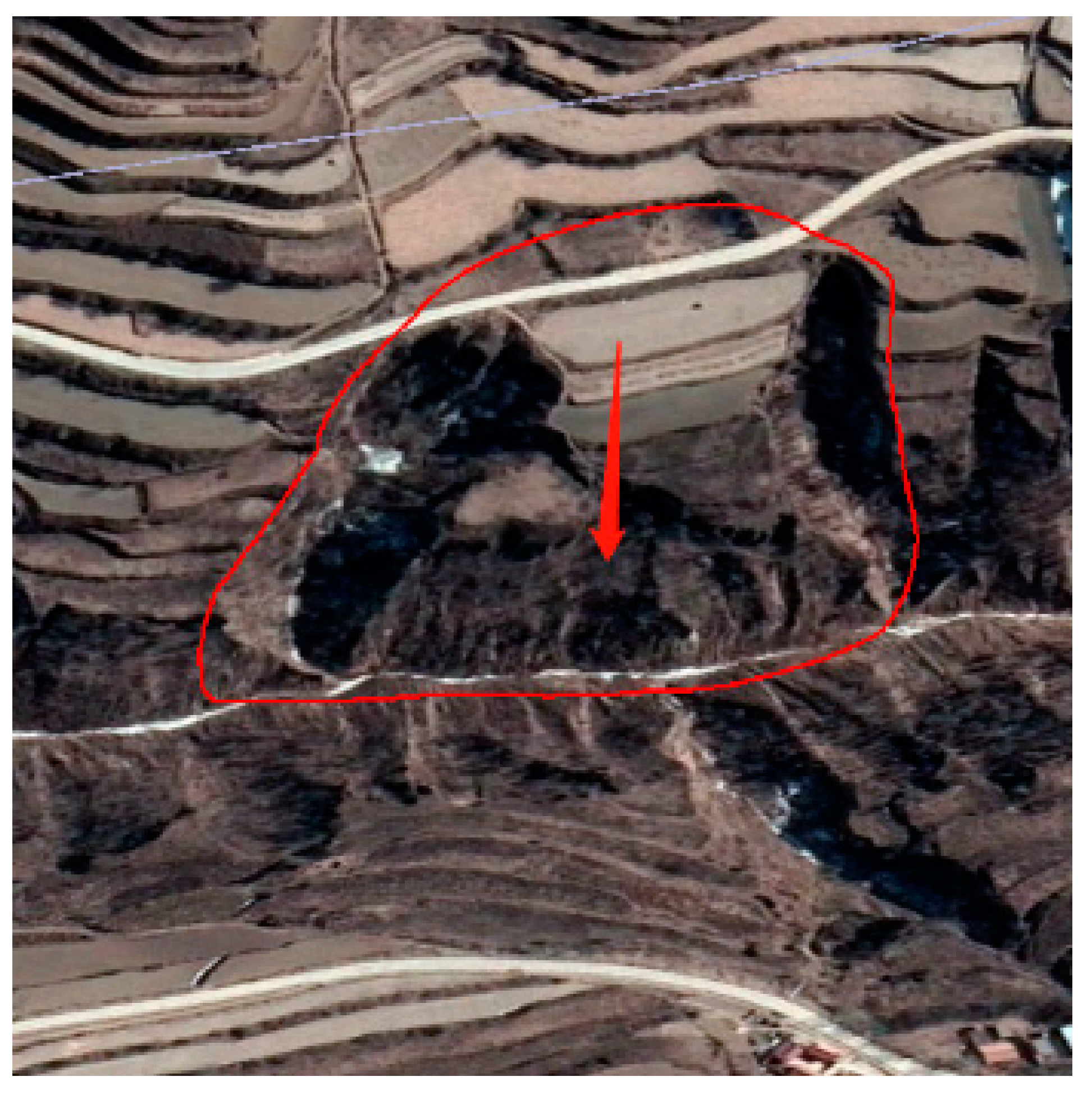 | 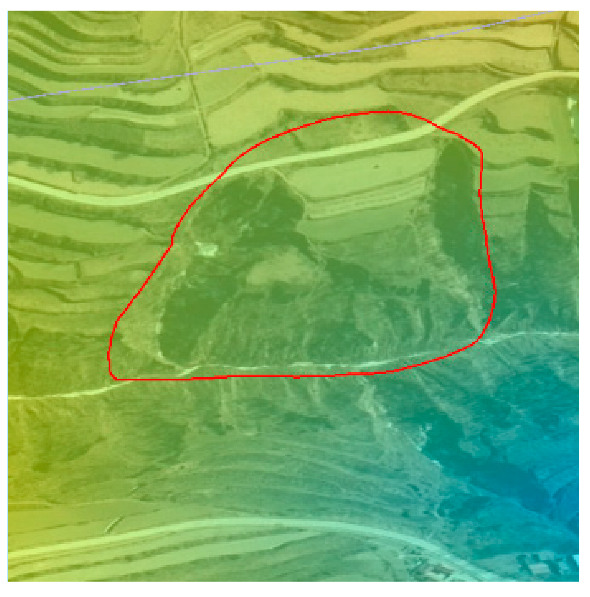 |
 Low deformation.
Disclaimer/Publisher’s Note: The statements, opinions and data contained in all publications are solely those of the individual author(s) and contributor(s) and not of MDPI and/or the editor(s). MDPI and/or the editor(s) disclaim responsibility for any injury to people or property resulting from any ideas, methods, instructions or products referred to in the content. |
© 2024 by the authors. Licensee MDPI, Basel, Switzerland. This article is an open access article distributed under the terms and conditions of the Creative Commons Attribution (CC BY) license (https://creativecommons.org/licenses/by/4.0/).
Share and Cite
Zhong, J.; Li, Q.; Zhang, J.; Luo, P.; Zhu, W. Risk Assessment of Geological Landslide Hazards Using D-InSAR and Remote Sensing. Remote Sens. 2024, 16, 345. https://doi.org/10.3390/rs16020345
Zhong J, Li Q, Zhang J, Luo P, Zhu W. Risk Assessment of Geological Landslide Hazards Using D-InSAR and Remote Sensing. Remote Sensing. 2024; 16(2):345. https://doi.org/10.3390/rs16020345
Chicago/Turabian StyleZhong, Jiaxin, Qiaomin Li, Jia Zhang, Pingping Luo, and Wei Zhu. 2024. "Risk Assessment of Geological Landslide Hazards Using D-InSAR and Remote Sensing" Remote Sensing 16, no. 2: 345. https://doi.org/10.3390/rs16020345
APA StyleZhong, J., Li, Q., Zhang, J., Luo, P., & Zhu, W. (2024). Risk Assessment of Geological Landslide Hazards Using D-InSAR and Remote Sensing. Remote Sensing, 16(2), 345. https://doi.org/10.3390/rs16020345


