Three-Dimensional Reconstruction of Partially Coherent Scatterers Using Iterative Sub-Network Generation Method


Abstract
1. Introduction
2. Basic Theory for SAR Tomography and PCS
2.1. Signal Model of Three-Dimensional SAR Tomography
2.2. Reference Network Method
2.3. Partially Coherent Scatterer (PCS)
2.3.1. Concept of PCS
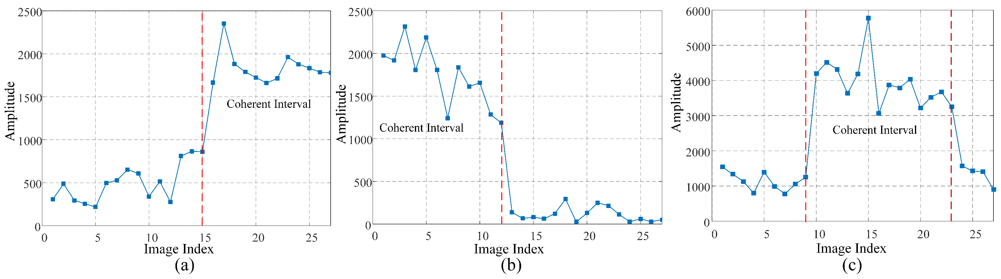
2.3.2. Coherent Intervals and Step Change Positions
- Appearing-type PCS (APCS). As shown in Figure 1a, the coherence interval of APCS starts from the step change position to the end of the time series. APCS initially presents as incoherent and turns coherent after the step change position. In urban areas, APCS may represent the new construction of buildings or the emergence of artificial targets.
- Disappearing-type PCS (DPCS). As shown in Figure 1b, the coherence interval of DPCS starts from the first acquisition time to the step change position. DPCS initially presents as coherent and turns incoherent after the step change position. The existence of DPCS may indicate the demolition of buildings, relocation of artificial targets, or the obstruction phenomenon due to the emergence of APCS.
- Visiting-type PCS (VPCS). As illustrated in Figure 1c, the coherence interval of VPCS is situated between two consecutive step change positions. VPCS differs from the above two types of PCSs, which have only one step change position, in terms of the least number of step change positions. In practical scenarios, VPCS is more likely to be observed in long time series, where the complete occurrence and disappearance of the target can be monitored.
3. Detection and 3D Reconstruction of PCS
3.1. PCS Detection for TomoSAR Based on Coherence Constraint Iterative Variance Analysis
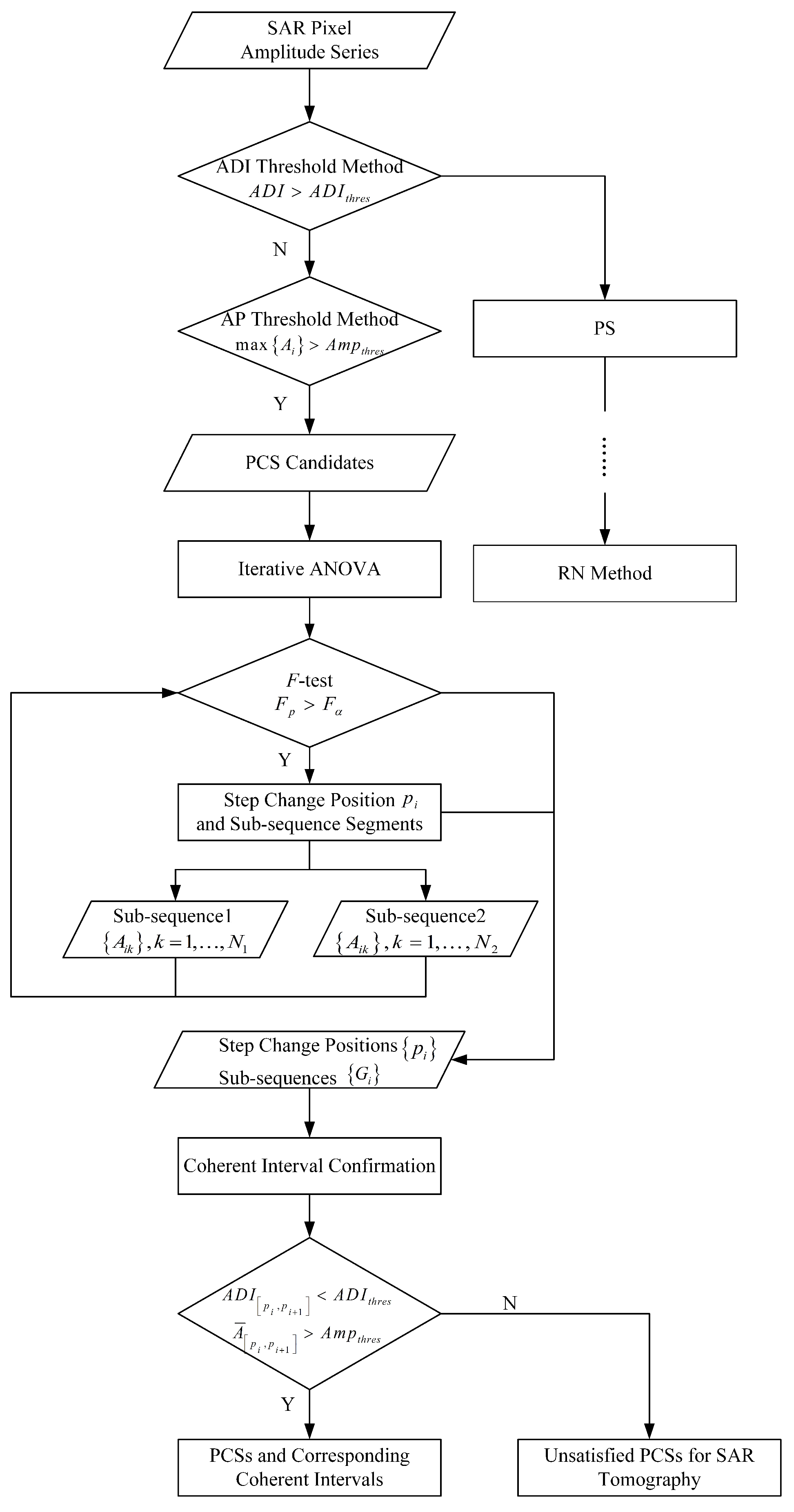
- Selecting PCS candidates to identify the existence of PCS at each pixel.
- Iteratively searching for step change positions of PCS candidates using ANOVA, considering the possibility of multiple positions.
- Confirming the identified step change positions and coherent intervals. As the time series are segmented into multiple sub-intervals, only coherent intervals suitable for SAR tomography processing are derived by imposing the coherence constraint.
3.1.1. PCS Candidates Selection
3.1.2. Iterative Analysis of Variance (ANOVA)
- Step 1: Search for a single step change position. Employ ANOVA to identify the initial step change position, denoted as .
- Step 2: Iterative search for additional step change positions.Following Step 1, divide the amplitude series into two intervals based on :. Perform Step 1 within these newly defined sub-intervals. Note that will vary due to changes in the length of the sub-sequences, which affects the degrees of freedom. Consequently, must be updated at each iteration.
- Step 3: Finalize the division of the amplitude series.Repeat Steps 1 and 2 iteratively to search for additional step change positions. Continue this process until no further step change positions can be identified from subsequent divisions. Assuming all step change positions are , the amplitude series are divided into M segments:
3.1.3. Coherent Interval Confirmation
- Coherence constraint. The amplitude series within coherence intervals should exhibit both a higher average amplitude and a lower ADI simultaneously. This can be formally expressed as:
- Observation quantity constraint. To ensure the feasibility and accuracy of the tomographic inversion, the suitable coherence intervals must contain a sufficient number of observations. Assuming that the minimum required number of observations for SAR tomography is D, the coherence interval for PCSs must meet the following condition [27,28]:
| Algorithm 1 Coherence constraint ANOVA |
|
3.2. Three-Dimensional Imaging of PCS by Iterative Sub-Network Generation Method
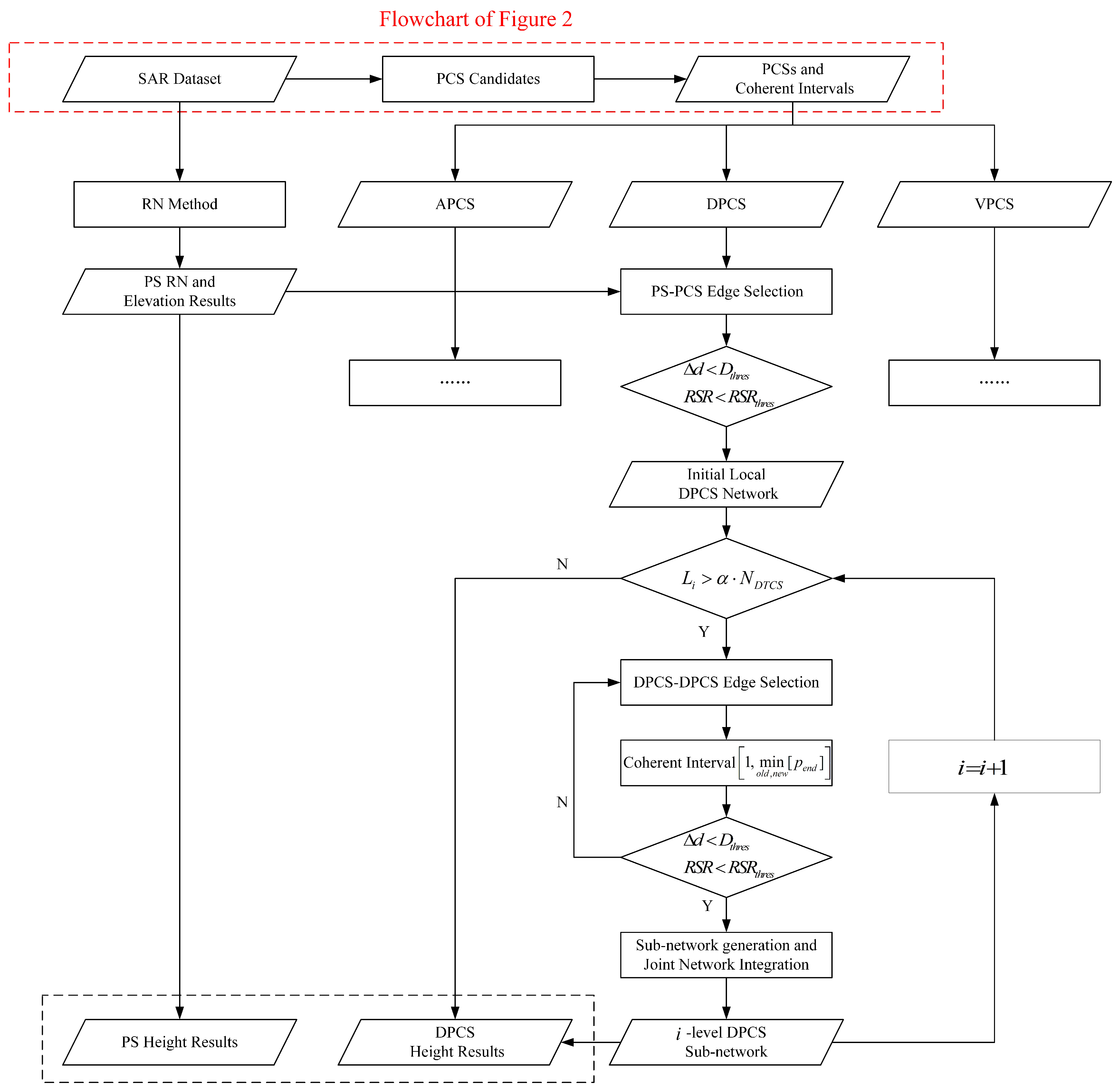
3.2.1. Initial Sub-Network Generation
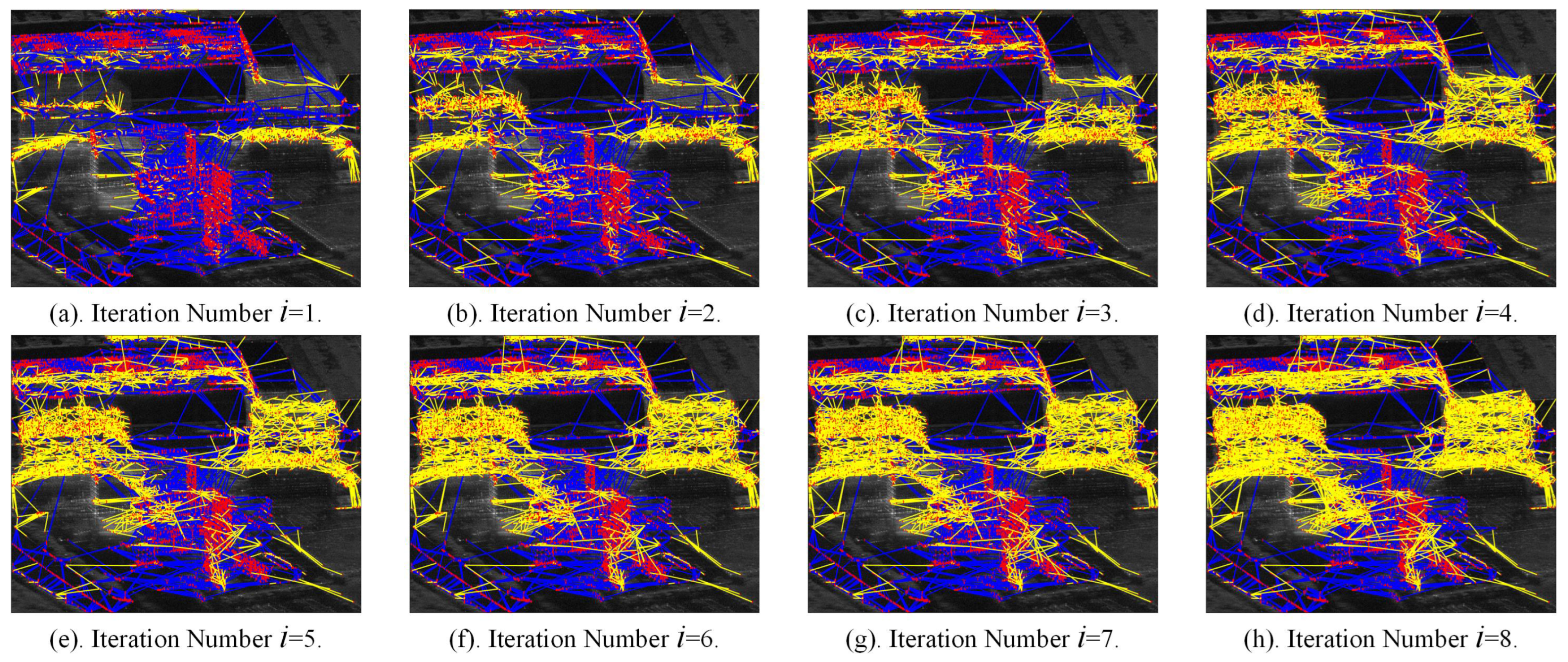
3.2.2. Iterative Sub-Network Generation
4. Results
4.1. Introduction to the SAR Dataset
4.2. PCS Detection Results
4.3. Height Estimation of PCSs
4.3.1. Height Estimation of PS
4.3.2. PCS Sub-Network
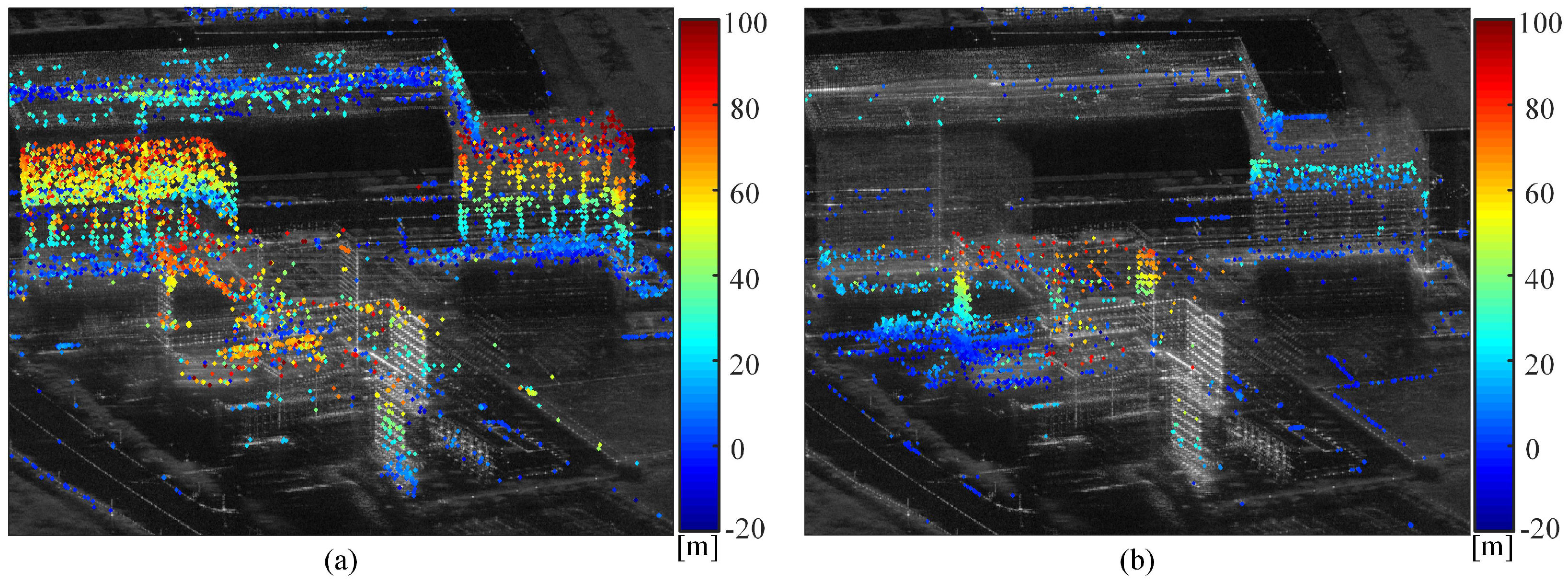
4.3.3. PCS Height Point Cloud Map
5. Discussion
6. Conclusions
Author Contributions
Funding
Data Availability Statement
Acknowledgments
Conflicts of Interest
References
- Reigber, A.; Moreira, A. First demonstration of airborne SAR tomography using multibaseline L-band data. IEEE Trans. Geosci. Remote Sens. 2000, 38, 2142–2152. [Google Scholar] [CrossRef] [Scilit]
- Fornaro, G.; Lombardini, F.; Serafino, F. Three-dimensional multipass SAR focusing: Experiments with long-term spaceborne data. IEEE Trans. Geosci. Remote Sens. 2005, 43, 702–714. [Google Scholar] [CrossRef] [Scilit]
- Reale, D.; Fornaro, G.; Pauciullo, A.; Zhu, X.; Bamler, R. Tomographic Imaging and Monitoring of Buildings with Very High Resolution SAR Data. IEEE Geosci. Remote Sens. Lett. 2011, 8, 661–665. [Google Scholar] [CrossRef] [Scilit]
- Ferretti, A.; Prati, C.; Rocca, F. Nonlinear subsidence rate estimation using permanent scatterers in differential SAR interferometry. IIEEE Trans. Geosci. Remote Sens. 2000, 38, 2202–2212. [Google Scholar] [CrossRef] [Scilit]
- Crosetto, M.; Monserrat, O. Persistent Scatterer Interferometry: A review. ISPRS J. Photogramm. Remote Sens. 2005, 115, 78–89. [Google Scholar] [CrossRef] [Scilit]
- Ma, P.F.; Lin, H. Robust detection of single and double persistent scatterers in urban built environments. IEEE Trans. Geosci. Remote Sens. 2015, 54, 2124–2139. [Google Scholar] [CrossRef] [Scilit]
- Wu, W.Q.; Hu, J.; Du, Z.G.; Hou, J.X.; Zheng, W.J.; Liu, J.H. A Network Optimized Ridge Estimator for Robust PSI Parameter Estimation and Its Application on Deformation Monitoring of Urban Area. IEEE J. Sel. Top. Appl. Earth Obs. Remote Sens. 2021, 14, 5436–5452. [Google Scholar] [CrossRef] [Scilit]
- Ferretti, A.; Prati, C.; Rocca, F. Permanent scatterers in SAR interferometry. IEEE Trans. Geosci. Remote Sens. 2001, 39, 8–20. [Google Scholar] [CrossRef] [Scilit]
- Ferretti, A.; Colesanti, C.; Perissin, D.; Prati, C.; Rocca, F. Evaluating the effect of the observation time on the distribution of SAR permanent scatterers. In Proceedings of the FRINGE 2003 Workshop, Frascati, Italy, 10–14 November 2003. [Google Scholar]
- Perissin, D.; Ferretti, A. Urban-Target Recognition by Means of Repeated Spaceborne SAR Images. IEEE Trans. Geosci. Remote Sens. 2007, 12, 4043–4058. [Google Scholar] [CrossRef] [Scilit]
- Zhang, L.; Ding, X.L.; Lu, Z. Ground settlement monitoring based on temporarily coherent points between two SAR acquisitions. ISPRS J. Photogramm. Remote Sens. 2011, 1, 146–152. [Google Scholar] [CrossRef] [Scilit]
- Zhang, L.; Lu, Z.; Ding, X.L.; Jung, H.S.; Feng, G.C.; Lee, C.W. Mapping ground surface deformation using temporarily coherent point SAR interferometry: Application to Los Angeles Basin. Remote Sens. Environ. 2012, 117, 429–439. [Google Scholar] [CrossRef] [Scilit]
- Perissin, D.; Wang, T. Repeat-pass SAR interferometry with partially coherent targets. IEEE Trans. Geosci. Remote Sens. 2012, 1, 271–280. [Google Scholar] [CrossRef] [Scilit]
- Esmaeili, M.; Motagh, M. Improved persistent scatterer analysis using amplitude dispersion index optimization of dual polarimetry data. ISPRS J. Photogramm. Remote Sens. 2011, 1, 108–114. [Google Scholar] [CrossRef] [Scilit]
- Ozan, D.; Daniele, P. Detection of Multitransition Abrupt Changes in Multitemporal SAR Images. IEEE J. Sel. Top. Appl. Earth Obs. Remote Sens. 2014, 8, 3239–3247. [Google Scholar]
- Hu, F.M.; Wu, J.C.; Chang, L.; Hanssen, R.F. Incorporating Temporary Coherent Scatterers in Multi-Temporal InSAR Using Adaptive Temporal Subsets. IEEE Trans. Geosci. Remote Sens. 2019, 10, 7658–7670. [Google Scholar] [CrossRef] [Scilit]
- Hu, F.M.; Wu, J.C. Detecting spatio-temporal urban surface changes using identified temporary coherent scatterers. J. Syst. Eng. Electron. 2021, 6, 1304–1317. [Google Scholar]
- Zhu, X.X.; Bamler, R. Demonstration of Super-Resolution for Tomographic SAR Imaging in Urban Environment. IEEE Trans. Geosci. Remote Sens. 2012, 50, 3150–3157. [Google Scholar] [CrossRef] [Scilit]
- Fornaro, G.; Serafino, F.; Soldovieri, F. Three-dimensional focusing with multipass SAR data. IEEE Trans. Geosci. Remote Sens. 2003, 3, 507–517. [Google Scholar] [CrossRef] [Scilit]
- Ji, Y.; Dong, Z.; Zhang, Y. Trans-ionospheric Synthetic Aperture Radar Observation: A Comprehensive Review. IEEE Geosci. Remote Sens. Mag. 2024; Early Access. [CrossRef] [Scilit]
- Doin, M.P.; Lasserre, C.; Peltzer, G. Corrections of stratified tropospheric delays in SAR interferometry: Validation with global atmospheric models. J. Appl. Geophys. 2009, 1, 35–50. [Google Scholar] [CrossRef] [Scilit]
- Sabater, J.M.; Hanssen, R.; Kampes, B.M.; Fusco, A.; Adam, N. Physical analysis of atmospheric delay signal observed in stacked. In Proceedings of the 2003 IEEE International Geoscience and Remote Sensing Symposium, Anchorage, AK, USA, 21 July 2003. [Google Scholar]
- Frey, O.; Hajnsek, I.; Wegmuller, U. Spaceborne SAR Tomography in Urban Areas. In Proceedings of the 2013 IEEE International Geoscience and Remote Sensing Symposium, Melbourne, Australia, 21–26 July 2013. [Google Scholar]
- Zhu, X.X.; Bamler, R. Tomographic SAR Inversion by L1-norm Regularization—The Compressive Sensing Approach. IEEE Trans. Geosci. Remote Sens. 2010, 48, 3839–3846. [Google Scholar] [CrossRef] [Scilit]
- Zhu, X.X.; Dong, Z.; Yu, A.X.; Wu, M.Q.; Li, D.X.; Zhang, Y.S. New approaches for robust and efficient detection of persistent scatterers in SAR tomography. Remote Sens. 2019, 11, 356. [Google Scholar] [CrossRef] [Scilit]
- Fornaro, G.; Serafino, F. Imaging of Single and Double Scatterers in Urban Areas via SAR Tomography. IEEE Trans. Geosci. Remote Sens. 2006, 44, 3497–3505. [Google Scholar] [CrossRef] [Scilit]
- Shi, Y.L.; Zhu, X.X.; Bamler, R. Nonlocal Compressive Sensing-Based SAR Tomography. IEEE Trans. Geosci. Remote Sens. 2019, 5, 3015–3024. [Google Scholar] [CrossRef] [Scilit]
- Wang, Y.; Dong, Z.; Wang, X.; Yu, A.; Peng, X. An improved bridge reference network for 3-D SAR tomography based on regional growing strategy. Int. J. Digit. Earth 2024, 17, 2398072. [Google Scholar] [CrossRef] [Scilit]
- Zhang, B.J.; Xu, G.; Yu, H.W.; Wang, H.; Pei, H.; Hong, W. Array 3-D SAR Tomography Using Robust Gridless Compressed Sensing. IEEE Trans. Geosci. Remote Sens. 2023, 61, 5205013. [Google Scholar] [CrossRef] [Scilit]
- Montazeri, S.; Rodriguez, G.F.; Zhu, X.X. Geocoding Error Correction for InSAR Point Clouds. Remote Sens. 2018, 10, 1523. [Google Scholar] [CrossRef] [Scilit]






| Parameters | Values |
|---|---|
| ADI threshold | 0.25 |
| Amplitude threshold | 272.05 |
| Significance level | 0.05 |
| Minmum interval length | 7 |
| Parameters | Values |
|---|---|
| Distance threshold | 150 m |
| Imaging quality constraint | 0.25 |
| Scaling factor | 0.01 |
| Iteration Number | Edges of New Sub-Network | APCSs of New Sub-Network | Proportion of the Total APCSs |
|---|---|---|---|
| 1 | 2025 | 2025 | 15.36% |
| 2 | 1940 | 1940 | 14.72% |
| 3 | 1666 | 1666 | 12.63% |
| 4 | 1360 | 1360 | 10.32% |
| 5 | 855 | 855 | 6.48% |
| 6 | 550 | 550 | 4.17% |
| 7 | 314 | 314 | 2.38% |
| 8 | 135 | 135 | 1.02% |
Disclaimer/Publisher’s Note: The statements, opinions and data contained in all publications are solely those of the individual author(s) and contributor(s) and not of MDPI and/or the editor(s). MDPI and/or the editor(s) disclaim responsibility for any injury to people or property resulting from any ideas, methods, instructions or products referred to in the content. |
© 2024 by the authors. Licensee MDPI, Basel, Switzerland. This article is an open access article distributed under the terms and conditions of the Creative Commons Attribution (CC BY) license (https://creativecommons.org/licenses/by/4.0/).
Share and Cite
Wang, X.; Dong, Z.; Wang, Y.; Chen, X.; Yu, A. Three-Dimensional Reconstruction of Partially Coherent Scatterers Using Iterative Sub-Network Generation Method. Remote Sens. 2024, 16, 3707. https://doi.org/10.3390/rs16193707
Wang X, Dong Z, Wang Y, Chen X, Yu A. Three-Dimensional Reconstruction of Partially Coherent Scatterers Using Iterative Sub-Network Generation Method. Remote Sensing. 2024; 16(19):3707. https://doi.org/10.3390/rs16193707
Chicago/Turabian StyleWang, Xiantao, Zhen Dong, Youjun Wang, Xing Chen, and Anxi Yu. 2024. "Three-Dimensional Reconstruction of Partially Coherent Scatterers Using Iterative Sub-Network Generation Method" Remote Sensing 16, no. 19: 3707. https://doi.org/10.3390/rs16193707
APA StyleWang, X., Dong, Z., Wang, Y., Chen, X., & Yu, A. (2024). Three-Dimensional Reconstruction of Partially Coherent Scatterers Using Iterative Sub-Network Generation Method. Remote Sensing, 16(19), 3707. https://doi.org/10.3390/rs16193707