Three Decades of Inundation Dynamics in an Australian Dryland Wetland: An Eco-Hydrological Perspective
Abstract
1. Introduction
- Assess the RaFMIC method [31] as a robust approach for creating a long-term, dense time series of inundation maps using earth observation data and validate the effectiveness of the Landsat-based wetland inundation maps generated by the RaFMIC method in assessing eco-hydrological responses across large wetland areas.
- Analyze long-term inundation dynamics across the catchment and compare these with climatic events, vegetation changes, and inflows.
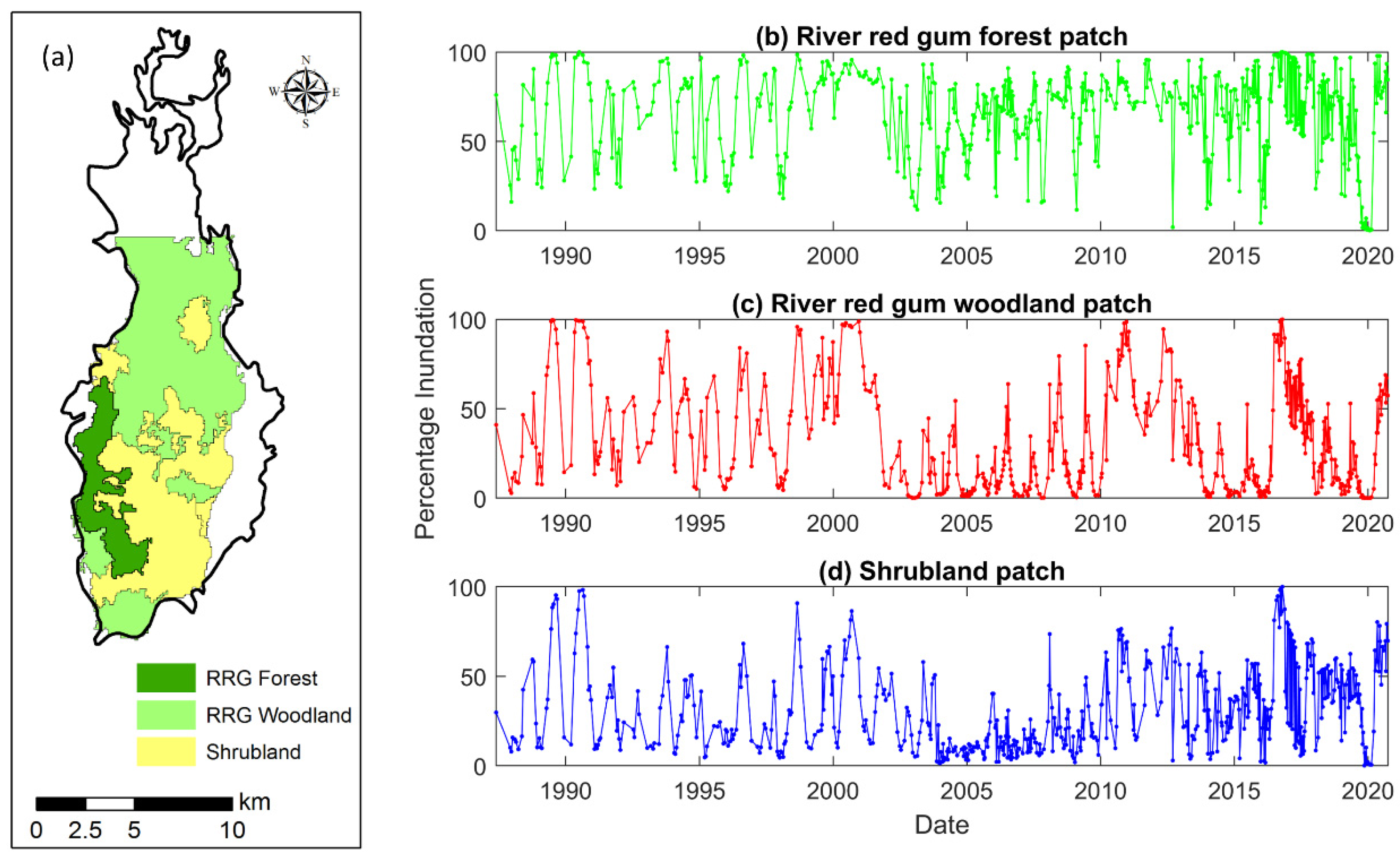
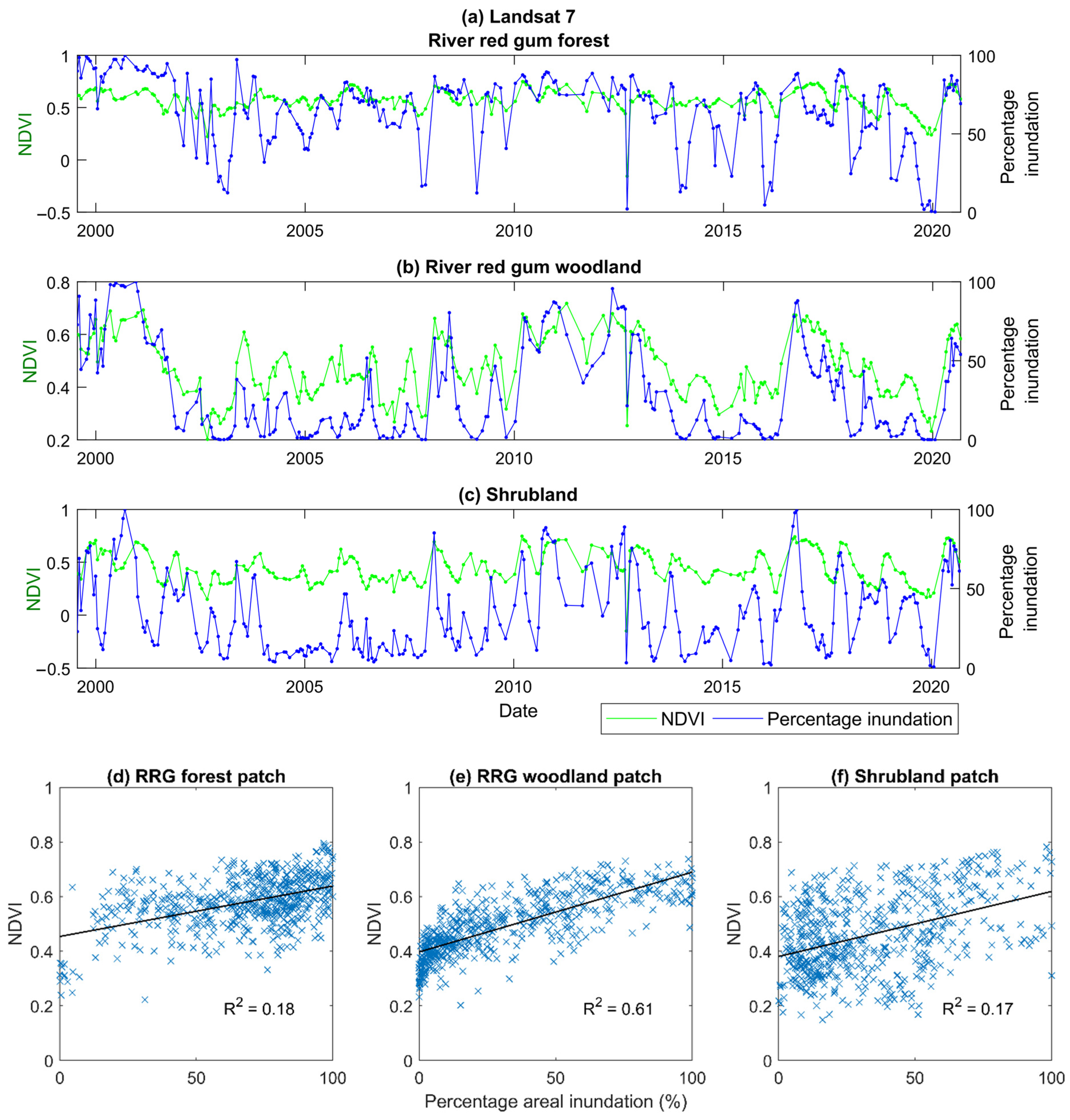
- Classify the wetland into zones based on the long-term probability of inundation and investigate their response to climatic variability and inflows. These zones will be useful for wetland management and assessment. Examining how the flood characteristics at each inundation class have influenced the development and distribution of wetland vegetation will shed light on the relationship between inundation dynamics and vegetation response. Vegetation patches defined by Quijano-Baron et al. [35] and the Normalized Difference Vegetation Index (NDVI) were used to analyze the vegetation response to inundation dynamics.
2. Materials and Methods
2.1. Study Area
2.2. Datasets
2.2.1. Inundation Maps
2.2.2. Landsat Imagery
2.2.3. Stream Discharge Data
2.2.4. Precipitation Data
2.2.5. LiDAR-Derived Digital Elevation Model (DEM)
2.3. Methodology
2.3.1. Comparison of Landsat Inundation Maps
2.3.2. Calculating the Probability of Inundation
2.3.3. Influence of Wetland Inundation Probability on Vegetation Dynamics
2.3.4. Wetness Index on Vegetation Dynamics
3. Results
3.1. Comparison of Inundated Areas
3.2. Analysing the Probability of Inundation
3.3. Vegetation Dynamics over the Northern Marshes and SWI
4. Discussion
5. Conclusions
Author Contributions
Funding
Data Availability Statement
Acknowledgments
Conflicts of Interest
References
- Lemly, A.D.; Kingsford, R.T.; Thompson, J.R. Irrigated agriculture and wildlife conservation: Conflict on a global scale. Environ. Manag. 2000, 25, 485–512. [Google Scholar] [CrossRef] [PubMed]
- Vörösmarty, C.J.; McIntyre, P.B.; Gessner, M.O.; Dudgeon, D.; Prusevich, A.; Green, P.; Glidden, S.; Bunn, S.E.; Sullivan, C.A.; Liermann, C.R. Global threats to human water security and river biodiversity. Nature 2010, 467, 555–561. [Google Scholar] [CrossRef] [PubMed]
- Thapa, R.; Thoms, M.C.; Reid, M.; Parsons, M. Do adaptive cycles of floodplain vegetation response to inundation differ among vegetation communities? River Res. Appl. 2020, 36, 553–566. [Google Scholar] [CrossRef]
- Wen, L.; Ling, J.; Saintilan, N.; Rogers, K. An investigation of the hydrological requirements of River Red Gum (Eucalyptus camaldulensis) Forest, using Classification and Regression Tree modelling. Ecohydrol. Ecosyst. Land Water Process Interact. Ecohydrogeomorphology 2009, 2, 143–155. [Google Scholar] [CrossRef]
- Capon, S.J.; Brock, M.A. Flooding, soil seed bank dynamics and vegetation resilience of a hydrologically variable desert floodplain. Freshw. Biol. 2006, 51, 206–223. [Google Scholar] [CrossRef]
- Cendón, D.I.; Larsen, J.R.; Jones, B.G.; Nanson, G.C.; Rickleman, D.; Hankin, S.I.; Pueyo, J.J.; Maroulis, J. Freshwater recharge into a shallow saline groundwater system, Cooper Creek floodplain, Queensland, Australia. J. Hydrol. 2010, 392, 150–163. [Google Scholar] [CrossRef]
- Doble, R.C.; Crosbie, R.S.; Smerdon, B.D.; Peeters, L.; Cook, F.J. Groundwater recharge from overbank floods. Water Resour. Res. 2012, 48, W09522. [Google Scholar] [CrossRef]
- Doody, T.M.; Benger, S.N.; Pritchard, J.L.; Overton, I.C. Ecological response of Eucalyptus camaldulensis (river red gum) to extended drought and flooding along the River Murray, South Australia (1997–2011) and implications for environmental flow management. Mar. Freshw. Res. 2014, 65, 1082–1093. [Google Scholar] [CrossRef]
- Overton, I.C.; Jolly, I.D.; Slavich, P.G.; Lewis, M.M.; Walker, G.R. Modelling vegetation health from the interaction of saline groundwater and flooding on the Chowilla floodplain, South Australia. Aust. J. Bot. 2006, 54, 207–220. [Google Scholar] [CrossRef]
- Chessman, B.C. Declines of freshwater turtles associated with climatic drying in Australia’s Murray–Darling Basin. Wildl. Res. 2012, 38, 664–671. [Google Scholar] [CrossRef]
- Wassens, S.; Walcott, A.; Wilson, A.; Freire, R. Frog breeding in rain-fed wetlands after a period of severe drought: Implications for predicting the impacts of climate change. Hydrobiologia 2013, 708, 69–80. [Google Scholar] [CrossRef]
- Arthur, A.D.; Reid, J.R.W.; Kingsford, R.T.; McGinness, H.M.; Ward, K.A.; Harper, M.J. Breeding flow thresholds of colonial breeding waterbirds in the Murray-Darling Basin, Australia. Wetlands 2012, 32, 257–265. [Google Scholar] [CrossRef]
- Rogers, K.; Ralph, T.J. Floodplain Wetland Biota in the Murray-Darling Basin: Water and Habitat Requirements; CSIRO PUBLISHING: Clayton, Australia, 2010. [Google Scholar]
- Wakeley, J.S.; Guilfoyle, M.P.; Antrobus, T.J.; Fischer, R.A.; Barrow, W.C.; Hamel, P.B. Ordination of breeding birds in relation to environmental gradients in three southeastern United States floodplain forests. Wetl. Ecol. Manag. 2007, 15, 417–439. [Google Scholar] [CrossRef]
- Pinel, S.; Bonnet, M.P.; Da Silva, J.S.; Sampaio, T.C.; Garnier, J.; Catry, T.; Calmant, S.; Fragoso, C.R., Jr.; Moreira, D.; Motta Marques, D. Flooding dynamics within an Amazonian floodplain: Water circulation patterns and inundation duration. Water Resour. Res. 2020, 56, e2019WR026081. [Google Scholar] [CrossRef]
- Wen, L.; Macdonald, R.; Morrison, T.; Hameed, T.; Saintilan, N.; Ling, J. From hydrodynamic to hydrological modelling: Investigating long-term hydrological regimes of key wetlands in the Macquarie Marshes, a semi-arid lowland floodplain in Australia. J. Hydrol. 2013, 500, 45–61. [Google Scholar] [CrossRef]
- Shaeri Karimi, S.; Saintilan, N.; Wen, L.; Valavi, R. Application of machine learning to model wetland inundation patterns across a large semiarid floodplain. Water Resour. Res. 2019, 55, 8765–8778. [Google Scholar] [CrossRef]
- Wen, L.; Saintilan, N. Linking local ecological outcomes with basin-wide water planning: A case study of Yanga National Park, an important Australian inland forested wetland. Hydrol. Sci. J. 2014, 59, 904–915. [Google Scholar] [CrossRef][Green Version]
- Chen, N.; He, Y.; Zhang, X. Nir-red spectra-based disaggregation of SMAP soil moisture to 250 m resolution based on smapex-4/5 in southeastern Australia. Remote Sens. 2017, 9, 51. [Google Scholar] [CrossRef]
- Poff, N.L.; Richter, B.D.; Arthington, A.H.; Bunn, S.E.; Naiman, R.J.; Kendy, E.; Acreman, M.; Apse, C.; Bledsoe, B.P.; Freeman, M.C. The ecological limits of hydrologic alteration (ELOHA): A new framework for developing regional environmental flow standards. Freshw. Biol. 2010, 55, 147–170. [Google Scholar] [CrossRef]
- Pekel, J.-F.; Cottam, A.; Gorelick, N.; Belward, A.S. High-resolution mapping of global surface water and its long-term changes. Nature 2016, 540, 418–422. [Google Scholar] [CrossRef]
- Mueller, N.; Lewis, A.; Roberts, D.; Ring, S.; Melrose, R.; Sixsmith, J.; Lymburner, L.; McIntyre, A.; Tan, P.; Curnow, S. Water observations from space: Mapping surface water from 25 years of Landsat imagery across Australia. Remote Sens. Environ. 2016, 174, 341–352. [Google Scholar] [CrossRef]
- Tulbure, M.G.; Broich, M.; Stehman, S.V.; Kommareddy, A. Surface water extent dynamics from three decades of seasonally continuous Landsat time series at subcontinental scale in a semi-arid region. Remote Sens. Environ. 2016, 178, 142–157. [Google Scholar] [CrossRef]
- Milzow, C.; Kgotlhang, L.; Kinzelbach, W.; Meier, P.; Bauer-Gottwein, P. The role of remote sensing in hydrological modelling of the Okavango Delta, Botswana. J. Environ. Manag. 2009, 90, 2252–2260. [Google Scholar] [CrossRef] [PubMed]
- Thomas, R.F.; Kingsford, R.T.; Lu, Y.; Cox, S.J.; Sims, N.C.; Hunter, S.J. Mapping inundation in the heterogeneous floodplain wetlands of the Macquarie Marshes, using Landsat Thematic Mapper. J. Hydrol. 2015, 524, 194–213. [Google Scholar] [CrossRef]
- Thomas, R.F.; Kingsford, R.T.; Lu, Y.; Hunter, S.J. Landsat mapping of annual inundation (1979–2006) of the Macquarie Marshes in semi-arid Australia. Int. J. Remote Sens. 2011, 32, 4545–4569. [Google Scholar] [CrossRef]
- Huang, C.; Peng, Y.; Lang, M.; Yeo, I.-Y.; McCarty, G. Wetland inundation mapping and change monitoring using Landsat and airborne LiDAR data. Remote Sens. Environ. 2014, 141, 231–242. [Google Scholar] [CrossRef]
- Inman, V.L.; Lyons, M.B. Automated inundation mapping over large areas using Landsat data and Google Earth Engine. Remote Sens. 2020, 12, 1348. [Google Scholar] [CrossRef]
- Li, L.; Chen, Y.; Xu, T.; Liu, R.; Shi, K.; Huang, C. Super-resolution mapping of wetland inundation from remote sensing imagery based on integration of back-propagation neural network and genetic algorithm. Remote Sens. Environ. 2015, 164, 142–154. [Google Scholar] [CrossRef]
- Xia, H.; Zhao, W.; Li, A.; Bian, J.; Zhang, Z. Subpixel inundation mapping using landsat-8 OLI and UAV data for a wetland region on the zoige plateau, China. Remote Sens. 2017, 9, 31. [Google Scholar] [CrossRef]
- Senanayake, I.P.; Yeo, I.-Y.; Kuczera, G.A. A Random Forest-Based Multi-Index Classification (RaFMIC) Approach to Mapping Three-Decadal Inundation Dynamics in Dryland Wetlands Using Google Earth Engine. Remote Sens. 2023, 15, 1263. [Google Scholar] [CrossRef]
- Fernando, W.A.M.; Senanayake, I. Developing a two-decadal time-record of rice field maps using Landsat-derived multi-index image collections with a random forest classifier: A Google Earth Engine based approach. Inf. Process. Agric. 2024, 11, 260–275. [Google Scholar] [CrossRef]
- Alioua, N.E.H.; Kemmouche, A. Assessing Urban Expansion of Algiers with Random Forest-Based Multi-Index Using Landsat Imagery. In Proceedings of the 2024 IEEE Mediterranean and Middle-East Geoscience and Remote Sensing Symposium (M2GARSS), Oran, Algeria, 15–17 April 2024; pp. 139–143. [Google Scholar]
- Gorelick, N.; Hancher, M.; Dixon, M.; Ilyushchenko, S.; Thau, D.; Moore, R. Google Earth Engine: Planetary-scale geospatial analysis for everyone. Remote Sens. Environ. 2017, 202, 18–27. [Google Scholar] [CrossRef]
- Quijano-Baron, J.; Carlier, R.; Rodriguez, J.F.; Sandi, S.G.; Saco, P.M.; Wen, L.; Kuczera, G. And we thought the Millennium Drought was bad: Assessing climate variability and change impacts on an Australian dryland wetland using an ecohydrologic emulator. Water Res. 2022, 218, 118487. [Google Scholar] [CrossRef] [PubMed]
- Jones, K.; Lanthier, Y.; van der Voet, P.; van Valkengoed, E.; Taylor, D.; Fernández-Prieto, D. Monitoring and assessment of wetlands using Earth Observation: The GlobWetland project. J. Environ. Manag. 2009, 90, 2154–2169. [Google Scholar] [CrossRef]
- Weise, K.; Paganini, M.; Wolf, B.; Fitoka, E.; Hansen, H.; Bonino, E.; van Valkengoed, E. globwetland II-the new opportunitieswith sentinel-2 for wetland mapping and monitoring. In Proceedings of the First Sentinel-2 Preparatory Symposium, Frascati, Italy, 23–27 April 2012. [Google Scholar]
- Dabrowska-Zielinska, K.; Bartold, M.; Gurdak, R. POLWET—System for new space-based products for wetlands under RAMSAR Convention. Geoinf. Issues 2016, 8, 25–35. [Google Scholar]
- Dvorett, D.; Bidwell, J.; Davis, C.; DuBois, C. Developing a hydrogeomorphic wetland inventory: Reclassifying national wetlands inventory polygons in geographic information systems. Wetlands 2012, 32, 83–93. [Google Scholar] [CrossRef]
- Spiers, A. Wetland inventory: Overview at a global scale. In Proceedings of the Wetland Inventory, Assessment and Monitoring: Practical Techniques and Identification of Major Issues, Dakar, Senegal, 8–14 November 1998; Proceedings of Workshop. 2001; pp. 23–30. [Google Scholar]
- Hughes, J. The current status of European wetland inventories and classifications. Classif. Inventory World’s Wetl. 1995, 16, 17–28. [Google Scholar]
- Naranjo, L. An evaluation of the first inventory of South American wetlands. Vegetatio 1995, 118, 125–129. [Google Scholar] [CrossRef]
- Mao, D.; Wang, Z.; Du, B.; Li, L.; Tian, Y.; Jia, M.; Zeng, Y.; Song, K.; Jiang, M.; Wang, Y. National wetland mapping in China: A new product resulting from object-based and hierarchical classification of Landsat 8 OLI images. ISPRS J. Photogramm. Remote Sens. 2020, 164, 11–25. [Google Scholar] [CrossRef]
- LaRocque, A.; Phiri, C.; Leblon, B.; Pirotti, F.; Connor, K.; Hanson, A. Wetland mapping with landsat 8 OLI, sentinel-1, ALOS-1 PALSAR, and LiDAR data in Southern New Brunswick, Canada. Remote Sens. 2020, 12, 2095. [Google Scholar] [CrossRef]
- Peng, K.; Jiang, W.; Hou, P.; Wu, Z.; Ling, Z.; Wang, X.; Niu, Z.; Mao, D. Continental-scale wetland mapping: A novel algorithm for detailed wetland types classification based on time series Sentinel-1/2 images. Ecol. Indic. 2023, 148, 110113. [Google Scholar] [CrossRef]
- Stubbs, Q.; Yeo, I.-Y.; Lang, M.; Townshend, J.; Sun, L.; Prestegaard, K.; Jantz, C. Assessment of Wetland Change on the Delmarva Peninsula from 1984 to 2010. J. Coast. Res. 2020, 36, 575–589. [Google Scholar] [CrossRef]
- Liu, Y.; Zhang, H.; Zhang, M.; Cui, Z.; Lei, K.; Zhang, J.; Yang, T.; Ji, P. Vietnam wetland cover map: Using hydro-periods Sentinel-2 images and Google Earth Engine to explore the mapping method of tropical wetland. Int. J. Appl. Earth Obs. Geoinf. 2022, 115, 103122. [Google Scholar] [CrossRef]
- Hardy, A.; Oakes, G.; Ettritch, G. Tropical wetland (TropWet) mapping tool: The automatic detection of open and vegetated waterbodies in Google Earth engine for tropical wetlands. Remote Sens. 2020, 12, 1182. [Google Scholar] [CrossRef]
- Turnbull, A.; Soto-Berelov, M.; Coote, M. Delineation and Classification of Wetlands in the Northern Jarrah Forest, Western Australia Using Remote Sensing and Machine Learning. Wetlands 2024, 44, 52. [Google Scholar] [CrossRef]
- Knight, A.; Tindall, D.; Wilson, B. A multitemporal multiple density slice method for wetland mapping across the state of Queensland, Australia. Int. J. Remote Sens. 2009, 30, 3365–3392. [Google Scholar] [CrossRef]
- Kingsford, R.T.; Thomas, R.F. The Macquarie Marshes in arid Australia and their waterbirds: A 50-year history of decline. Environ. Manag. 1995, 19, 867–878. [Google Scholar] [CrossRef]
- Yu, L.; García, A.; Chivas, A.R.; Tibby, J.; Kobayashi, T.; Haynes, D. Ecological change in fragile floodplain wetland ecosystems, natural vs human influence: The Macquarie Marshes of eastern Australia. Aquat. Bot. 2015, 120, 39–50. [Google Scholar] [CrossRef]
- McComb, A.J.; Lake, P.S. The Conservation of Australian Wetlands; Surrey Beatty Sydney: Sydney, Australia, 1988. [Google Scholar]
- Matthews, G.V.T. The Ramsar Convention on Wetlands: Its History and Development. In Convention on Wetlands of International Importance Especially as Waterfowl Habitat; Ramsar Convention Bureau: Gland, Switzerland, 1993; Available online: https://policycommons.net/artifacts/1374228/the-ramsar-convention-on-wetlands/1988468/ (accessed on 10 March 2024).
- Thomas, R.F.; Ocock, J.F. Macquarie Marshes: Murray-Darling River Basin (Australia). In The Wetland Book; Finlayson, C.M., Milton, G.R., Prentice, R.C., Davidson, N.C., Eds.; Srpinger: Berlin/Heidelberg, Germany, 2018. [Google Scholar]
- Sandi, S.G.; Saco, P.M.; Rodriguez, J.F.; Saintilan, N.; Wen, L.; Kuczera, G.; Riccardi, G.; Willgoose, G. Patch organization and resilience of dryland wetlands. Sci. Total Environ. 2020, 726, 138581. [Google Scholar] [CrossRef]
- Kingsford, R.; Johnson, W. Impact of water diversions on colonially-nesting waterbirds in the Macquarie Marshes of arid Australia. Colon. Waterbirds 1998, 21, 159–170. [Google Scholar] [CrossRef]
- Kingsford, R.T.; Auld, K.M. Waterbird breeding and environmental flow management in the Macquarie Marshes, arid Australia. River Res. Appl. 2005, 21, 187–200. [Google Scholar] [CrossRef]
- Ralph, T.J.; Hesse, P.P.; Kobayashi, T. Wandering wetlands: Spatial patterns of historical channel and floodplain change in the Ramsar-listed Macquarie Marshes, Australia. Mar. Freshw. Res. 2016, 67, 782–802. [Google Scholar] [CrossRef]
- Sandi, S.G.; Saco, P.M.; Saintilan, N.; Wen, L.; Riccardi, G.; Kuczera, G.; Willgoose, G.; Rodríguez, J.F. Detecting inundation thresholds for dryland wetland vulnerability. Adv. Water Resour. 2019, 128, 168–182. [Google Scholar] [CrossRef]
- Smith, N.R. Suspended Sediment Transport and the Implications on River Channel Breakdown: Northern Macquarie Marshes, NSW; Macquarie University: Ryde, NSW, Australia, 2014. [Google Scholar]
- Ren, S.; Kingsford, R.T.; Thomas, R.F. Modelling flow to and inundation of the Macquarie Marshes in arid Australia. Environmetrics 2010, 21, 549–561. [Google Scholar] [CrossRef]
- Ren, S.; Kingsford, R.T. Statistically integrated flow and flood modelling compared to hydrologically integrated quantity and quality model for annual flows in the regulated Macquarie River in arid Australia. Environ. Manag. 2011, 48, 177–188. [Google Scholar] [CrossRef] [PubMed]
- Kingsford, R.T. Ecological impacts of dams, water diversions and river management on floodplain wetlands in Australia. Austral Ecol. 2000, 25, 109–127. [Google Scholar] [CrossRef]
- Rayner, T.S.; Jenkins, K.M.; Kingsford, R.T. Small environmental flows, drought and the role of refugia for freshwater fish in the Macquarie Marshes, arid Australia. Ecohydrol. Ecosyst. Land Water Process Interact. Ecohydrogeomorphol. 2009, 2, 440–453. [Google Scholar] [CrossRef]
- van Dijk, A.I.; Beck, H.E.; Crosbie, R.S.; de Jeu, R.A.; Liu, Y.Y.; Podger, G.M.; Timbal, B.; Viney, N.R. The Millennium Drought in southeast Australia (2001–2009): Natural and human causes and implications for water resources, ecosystems, economy, and society. Water Resour. Res. 2013, 49, 1040–1057. [Google Scholar] [CrossRef]
- Berney, P.; Hosking, T. Opportunities and challenges for water-dependent protected area management arising from water management reform in the Murray–Darling Basin: A case study from the Macquarie Marshes in Australia. Aquat. Conserv. Mar. Freshw. Ecosyst. 2016, 26, 12–28. [Google Scholar] [CrossRef]
- McLoughlin, C.A.; Kingsford, R.T.; Johnson, W. Learning consciousness in managing water for the environment, exemplified using Macquarie River and Marshes, Australia. Mar. Freshw. Res. 2024, 75, MF24049. [Google Scholar] [CrossRef]
- Akter, S.; Grafton, R.Q.; Merritt, W.S. Integrated hydro-ecological and economic modeling of environmental flows: Macquarie Marshes, Australia. Agric. Water Manag. 2014, 145, 98–109. [Google Scholar] [CrossRef]
- Tucker, C.J. Red and photographic infrared linear combinations for monitoring vegetation. Remote Sens. Environ. 1979, 8, 127–150. [Google Scholar] [CrossRef]
- Ashouri, H.; Hsu, K.-L.; Sorooshian, S.; Braithwaite, D.K.; Knapp, K.R.; Cecil, L.D.; Nelson, B.R.; Prat, O.P. PERSIANN-CDR: Daily precipitation climate data record from multisatellite observations for hydrological and climate studies. Bull. Am. Meteorol. Soc. 2015, 96, 69–83. [Google Scholar] [CrossRef]
- Hsu, K.-l.; Gao, X.; Sorooshian, S.; Gupta, H.V. Precipitation estimation from remotely sensed information using artificial neural networks. J. Appl. Meteorol. 1997, 36, 1176–1190. [Google Scholar] [CrossRef]
- Sorooshian, S.; Hsu, K.; Braithwaite, D.; Ashouri, H.; Program, N.C. NOAA Climate Data Record (CDR) of Precipitation Estimation from Remotely Sensed Information using Artificial Neural Networks (PERSIANN-CDR), Version 1 Revision 1. 2014. Available online: https://doi.org/10.7289/V51V5BWQ (accessed on 10 January 2021).
- Markham, B.L.; Storey, J.C.; Williams, D.L.; Irons, J.R. Landsat sensor performance: History and current status. IEEE Trans. Geosci. Remote Sens. 2004, 42, 2691–2694. [Google Scholar] [CrossRef]
- Bowen, S.; Simpson, S.; Honeysett, J.; Humphries, J. Technical report: Vegetation extent and condition mapping of the. Aust. For. 2019, 49, 4–15. [Google Scholar]
- Beven, K.J.; Kirkby, M.J. A physically based, variable contributing area model of basin hydrology/Un modèle à base physique de zone d′appel variable de l′hydrologie du bassin versant. Hydrol. Sci. J. 1979, 24, 43–69. [Google Scholar] [CrossRef]
- Böhner, J.; Selige, T. Spatial prediction of soil attributes using terrain analysis and climate regionalisation. In SAGA-Analyses and Modelling Applications; Goltze: Göttingen, Germany, 2006. [Google Scholar]
- Conrad, O.; Bechtel, B.; Bock, M.; Dietrich, H.; Fischer, E.; Gerlitz, L.; Wehberg, J.; Wichmann, V.; Böhner, J. System for automated geoscientific analyses (SAGA) v. 2.1. 4. Geosci. Model Dev. 2015, 8, 1991–2007. [Google Scholar] [CrossRef]
- Millard, K.; Richardson, M. Wetland mapping with LiDAR derivatives, SAR polarimetric decompositions, and LiDAR–SAR fusion using a random forest classifier. Can. J. Remote Sens. 2013, 39, 290–307. [Google Scholar] [CrossRef]
- Olaya, V.; Conrad, O. Geomorphometry in SAGA. Dev. Soil Sci. 2009, 33, 293–308. [Google Scholar]
- Wittwer, G. Estimating the Regional Economic Impacts of the 2017 to 2019 Drought on NSW and the Rest of Australia; Centre of Policy Studies, Victoria University: Melbourne, VIC, Australia, 2020. [Google Scholar]
- Luo, J.-J.; Liu, G.; Hendon, H.; Alves, O.; Yamagata, T. Inter-basin sources for two-year predictability of the multi-year La Niña event in 2010–2012. Sci. Rep. 2017, 7, 2276. [Google Scholar] [CrossRef] [PubMed]
- Catelotti, K.; Kingsford, R.; Bino, G.; Bacon, P. Inundation requirements for persistence and recovery of river red gums (Eucalyptus camaldulensis) in semi-arid Australia. Biol. Conserv. 2015, 184, 346–356. [Google Scholar] [CrossRef]
- Templet, P.H.; Meyer-Arendt, K.J. Louisiana wetland loss: A regional water management approach to the problem. Environ. Manag. 1988, 12, 181–192. [Google Scholar] [CrossRef]
- Brandis, K.; Nairn, L.; Porter, J.; Kingsford, R. Preliminary Assessment for the Environmental Water Requirements of Waterbird Species in the Murray Darling Basin; University of New South Wales: Sydney, NSW, Australia, 2009. [Google Scholar]
- Bino, G.; Sisson, S.A.; Kingsford, R.T.; Thomas, R.F.; Bowen, S. Developing state and transition models of floodplain vegetation dynamics as a tool for conservation decision-making: A case study of the Macquarie Marshes Ramsar wetland. J. Appl. Ecol. 2015, 52, 654–664. [Google Scholar] [CrossRef]
- Sandi, S.; Rodriguez, J.; Saco, P.; Saintilan, N.; Wen, L.; Kuczera, G. Development of a vegetation dynamics model for freshwater wetland assessment in the Macquarie Marshes. In Proceedings of the 36th Hydrology and Water Resources Symposium: The Art and Science of Water, HWRS 2015, Hobart, TAS, Australia, 7–10 December 2015; pp. 948–955. [Google Scholar]
- Sandi, S.G.; Rodriguez, J.F.; Saco, P.M.; Wen, L.; Saintilan, N. Linking hydraulic regime characteristics to vegetation status in the Macquarie Marshes. In Proceedings of the 11th International Symposium on Ecohydraulics (ISE 2016), Melbourne, VIC, Australia, 7–12 February 2016; p. 218. [Google Scholar]
- Roberts, J.; Marston, F. Water Regime for Wetland and Floodplain Plants: A Source Book for the Murray-Darling Basin; National Water Commission: Canberra, Australia, 2011. [Google Scholar]
- Bartold, M.; Kluczek, M. A Machine Learning Approach for Mapping Chlorophyll Fluorescence at Inland Wetlands. Remote Sens. 2023, 15, 2392. [Google Scholar] [CrossRef]
- Wei, Z.; Wan, X. Spatial and temporal characteristics of NDVI in the Weihe River Basin and its correlation with terrestrial water storage. Remote Sens. 2022, 14, 5532. [Google Scholar] [CrossRef]
- Feng, S.; Zhang, Z.; Zhao, S.; Guo, X.; Zhu, W.; Das, P. Time lag effect of vegetation response to seasonal precipitation in the Mara River Basin. Ecol. Process. 2023, 12, 49. [Google Scholar] [CrossRef]
- Kingsford, R.; Thomas, R. Destruction of wetlands and waterbird populations by dams and irrigation on the Murrumbidgee River in arid Australia. Environ. Manag. 2004, 34, 383–396. [Google Scholar] [CrossRef]
- Donnelly, J.P.; Moore, J.N.; Casazza, M.L.; Coons, S.P. Functional wetland loss drives emerging risks to waterbird migration networks. Front. Ecol. Evol. 2022, 10, 844278. [Google Scholar] [CrossRef]
- Lagos, N.A.; Paolini, P.; Jaramillo, E.; Lovengreen, C.; Duarte, C.; Contreras, H. Environmental processes, water quality degradation, and decline of waterbird populations in the Rio Cruces wetland, Chile. Wetlands 2008, 28, 938–950. [Google Scholar] [CrossRef]


Disclaimer/Publisher’s Note: The statements, opinions and data contained in all publications are solely those of the individual author(s) and contributor(s) and not of MDPI and/or the editor(s). MDPI and/or the editor(s) disclaim responsibility for any injury to people or property resulting from any ideas, methods, instructions or products referred to in the content. |
© 2024 by the authors. Licensee MDPI, Basel, Switzerland. This article is an open access article distributed under the terms and conditions of the Creative Commons Attribution (CC BY) license (https://creativecommons.org/licenses/by/4.0/).
Share and Cite
Senanayake, I.P.; Yeo, I.-Y.; Kuczera, G.A. Three Decades of Inundation Dynamics in an Australian Dryland Wetland: An Eco-Hydrological Perspective. Remote Sens. 2024, 16, 3310. https://doi.org/10.3390/rs16173310
Senanayake IP, Yeo I-Y, Kuczera GA. Three Decades of Inundation Dynamics in an Australian Dryland Wetland: An Eco-Hydrological Perspective. Remote Sensing. 2024; 16(17):3310. https://doi.org/10.3390/rs16173310
Chicago/Turabian StyleSenanayake, Indishe P., In-Young Yeo, and George A. Kuczera. 2024. "Three Decades of Inundation Dynamics in an Australian Dryland Wetland: An Eco-Hydrological Perspective" Remote Sensing 16, no. 17: 3310. https://doi.org/10.3390/rs16173310
APA StyleSenanayake, I. P., Yeo, I.-Y., & Kuczera, G. A. (2024). Three Decades of Inundation Dynamics in an Australian Dryland Wetland: An Eco-Hydrological Perspective. Remote Sensing, 16(17), 3310. https://doi.org/10.3390/rs16173310


