Abstract
Dryland occupies about 46% of the global land surface area (except Antarctica) and is the most vulnerable area to climate change. From the conditions of vegetation and land surface wetness and blown sand phenomena, a simple observation system was developed to monitor regional wind erosion and applied to Khuld of Mongolia, which is sensitive to drought and desertification. The system was composed of instruments that observed blown sand, vegetation amount, land surface wetness, and landscape features related to regional wind erosion. Sixteen blown sand and eight sandstorm events were evaluated from 5 March to 5 June 2023 (i.e., during the Asian dust season in northeast Asia). The normalized difference vegetation index and visible images showed that the vegetation amount was considerably less, and the developed moisture index related to land surface wetness indicated dry conditions. Combining the results of blown sand, these indices, and visible images, land surface conditions during the analysis period were likely to occur with blown sand events.
1. Introduction
Dryland covers 46% of the total global land area (except Antarctica), and one-third of the world’s population lives there [1]. According to the most recent Intergovernmental Panel on Climate Change (IPCC) report, these arid areas are highly vulnerable to climate change and will likely face more extreme weather events as global warming progresses in the future [1,2,3]. The impacts will be significant not only for dryland countries but also for others, such as Japan, that depend on the imported goods (e.g., agricultural products) from these areas. For Japan, which has ratified the United Nations Convention to Combat Desertification (UNCCD), it is important to provide international aid from a technological perspective in response to drought and desertification (i.e., land degradation in arid regions) in dryland countries [4,5].
Although several climate-based methods (e.g., an aridity index) have been widely used to define arid regions [3,6,7,8], desertification has generally been assessed using complex methods based on various factors in individual dryland regions. These kinds of methods are effective when the corresponding area is small but may be unsuitable for uniform evaluation of larger areas, and a common measure is needed to estimate the degree of desertification from a global perspective [9]. A candidate to be considered as a common “yardstick” is the conditions of vegetation and soil, which can represent the progress of desertification. Monitoring the degradation or interactions of vegetation and soil can lead to an objective assessment of desertification.
For several years, observation results regarding the relationship among blown sand phenomena, dust emissions, and land surface conditions have been accumulated in China and Mongolia [10,11,12,13,14]. Their studies indicated that the occurrence of blown sand or dust emission coincides with wind erosion due to land degradation related to meteorological drought and irrational human activities [15]. Thus, to know the physical process of wind erosion, it is important to clarify the effect of land surface conditions [16]. For example, wind erosion tends to increase as the vegetation cover and soil water content decrease [16,17]. A past study indicated that a normalized difference vegetation index (NDVI) of 0.2 was the threshold for the occurrence of blown sand [10]. This threshold has already been used in previous studies to monitor land degradation and dust emissions utilizing satellite data [8,18]. Thermal indices using land surface temperature (LST) were identified as the most influential variable for land surface wetness [19]. Ref. [20] proposed the index that uses the difference in LST between day and night. The index has been used to identify degraded lands in China and Mongolia that are source areas of Asian dust [18]. Years in which large increases in degraded land area were identified have been found, using the index, to correspond to major droughts in Mongolia [21]. However, these results were obtained by satellite for at least a 16-day interval over a wide area (5 km resolution), and simultaneously observed results of regional blown sand phenomena and related land surface conditions were impossible to obtain every day. For sustainable land management and further development of the physical knowledge of wind erosion, a ground-based monitoring system is absolutely required for each region.
The objective of this study is to develop a simple in situ monitoring system for wind erosion, which makes a clear departure from general weather stations. In general weather stations, there is ambiguity due to the fact that meteorological staff, complying with the World Meteorological Organization’s (WMO) regulations, judge blown sand events based on their own visual observations [17,19]. However, the advantage of the proposed system is that it can count the physical number of blown sand particles and understand the state of land surface conditions objectively during a blown sand event. In this study, a system to collect data on saltation number, vegetation conditions, and land surface wetness was introduced and its practical use was examined in an actual arid field (Khuld of Mongolia) from 5 March to 5 June 2023.
2. Materials and Methods
2.1. Background of System Construction
Wind erosion is related to blown sand phenomena or dust emissions, and interactions with the conditions of the land surface, that is, vegetation roughness, surface soil water content, salt concentration, and type of surface crust [13,16]. In arid environments, in particular, the vegetation amount and land surface wetness play critical roles in controlling the initiation of wind-driven sand transport [16,22] (Figure 1).
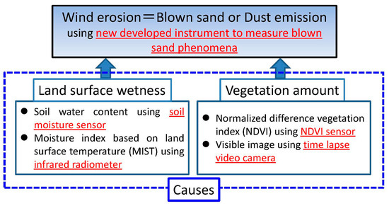
Figure 1.
Causes related to wind erosion (= blown sand), and their observation components shown by red color.
The proposed system collects data about blown sand using a newly developed instrument, vegetation amount using an NDVI sensor, land surface wetness using a soil moisture sensor and infrared radiometer, and other aspects of the landscape related to wind erosion using a time-lapse video camera, which make a clear departure from general weather stations (Figure 1).
The elements of the system and their components are shown in Figure 2. This system aims to use few meteorological data to evaluate these elements regionally. Since dust emissions in Figure 1 are proportional to the occurrence of blown sand, represented by saltation [10,16], its observation was not considered in the system.
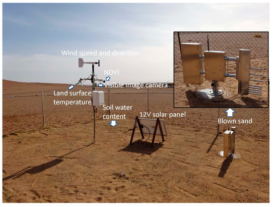
Figure 2.
Overview of the proposed monitoring system for wind erosion at the observation station in Khuld, Mongolia.
2.2. Observation Methods
The observation station at Khuld (45°13′32.41″N, 105°33′10.79″E, 1336 m above sea level) is located at the boundary between steppe (grassland plains without closed forests) and dry steppe (grassland plains where the large number of degraded plant species are observed) in Mongolia [23] (Figure 3). The average annual rainfall from 2009 to 2018 was 119 mm. It was selected as a monitoring site because it is located in an area known to be sensitive to drought and desertification [24,25]. Data from 5 March to 5 June 2023 were collected and analyzed (i.e., during the Asian dust season in northeast Asia).
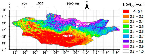
Figure 3.
Spatial distribution of yearly maximum NDVI (NDVImax) in Mongolia in 2020 with a resolution of 0.05° latitude × 0.05° longitude. The distribution was calculated from the daily MODIS data product MOD-09CMG, which was downloaded from the Land Processes Distributed Active Archive Center (https://lpdaac.usgs.gov/).
Asian dust events were observed in Japan 2–4 days after the saltation events indicated in Section 3.3 (https://www.data.jma.go.jp/gmd/env/kosahp/kosa_table_2023.html, accessed on 6 September 2024). Most Asian dust trajectories from 2014 to 2021 passed through central Mongolia (100°E–110°E) [18]. Actually, back trajectory analysis results showed that the trajectories passed through central Mongolia, including Khuld, in the case of Asian dust observed over Japan on 12 April (DOY = 102) and 23 May (DOY = 143) in Fukuoka City (33.59°N, 130.40°E) using the METEX (Meteorological Data Explorer) developed by the Center for Global Environmental Research (CGER), Earth System Division (ESD), and National Institute for Environmental Studies (NIES) (https://db.cger.nies.go.jp/ged/metex/ja/index.html, accessed on 6 September 2024) (Figure 4). What we would like to say here is that Khuld is also included in the path of Asian dust and not whether this analysis is comparable to the in situ data measured by the monitoring system.
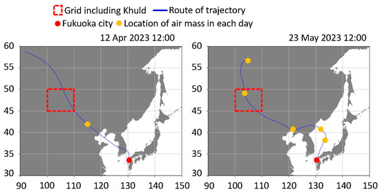
Figure 4.
Backward trajectories ending at 500 m altitude above Fukuoka City obtained by METEX on 12 April and 23 May 2023. Red dashed squares indicate the grid including Khuld. Red and orange dots show the locations of Fukuoka City and the location of each day, respectively.
The observed data included wind speed and direction (wind monitor YG5103, R.M. Young, MI, USA; 2 m above the ground; a four-blade helicoid propeller used to measure wind speed generates an AC sine wave signal upon rotation, and wind direction is determined by a vane attached to a precision potentiometer inside an internal housing), volumetric soil water content (SWC) (soil moisture sensor ECH2O EC5, METER, NE Hopkins Ct. Pullman, WA, USA; 3 cm below the ground surface; SWC is determined by measuring the dielectric constant of the media using capacitate/frequency domain technology), land surface temperature (LST) with 44° field of view (infrared radiometer SI-411, Apogee, North Rogan, UT, USA; 1.67 m above the ground; LST is determined by measuring the radiation emission within the atmospheric window from 8 to 14 μm), upward and downward red (650 nm) and near-infrared (NIR) (810 nm) irradiance as a spectral reflectance factor with a 180° field of view (NDVI sensor S2-111, Apogee, North Rogan, UT, USA; 1.7 m above the ground; this instrument has two band sensors consisting of a cast acrylic diffuser or acrylic window, and a pair of photodiodes that measure specific wavelength ranges), and visible landscape images (time-lapse video camera TCL-200, Brinno, Taipei, Taiwan; 1.64 m above the ground). Measurement intervals were 1 s (second) for wind speed and direction and 10 s for volumetric SWC and LST. These data were collected with a data logger (CR-310WIFI, Campbell Scientific, North Rogan, UT, USA), and averaged over 10 min intervals. The measurement interval of red and NIR irradiance was 1 s; values were averaged over 60 min intervals with a data logger (MCR4V, T & D, Nagano, Japan). A landscape image was taken by the time-lapse camera only once at noon each day to preserve the camera battery.
In addition, the most important instrument in the system was newly developed to measure blown sand phenomena (Patent Number 7510168 by the Japan Patent Office). The instrument was used to measure the saltation number. Here, saltation is a specific type of particle transported by wind [10,16]. It uses a piezoelectric transducer equipped with high-precision ultrasonic sensors [26,27], and it has been demonstrated and verified in wind tunnel and field experiments at the Tottori Sand Dunes, Japan [28,29,30]. With this instrument, the piezoelectric signals generated by collisions between blown sand grains and the sensor surface could be quantified. The short response time of the piezoelectric signal (0.001 s or less) meant that the saltation number could be determined with a high degree of accuracy. The instrument was developed so that the piezoelectric sensor could measure the saltation number at 8 arbitrary heights (5, 8, 11, 14, 17, 25, 30, and 35 cm above the ground) simultaneously to measure blown sand flux (Figure 2). A maximum height of 35 cm was chosen because previous quantitative analyses of the structural characteristics of wind-blown sand have concluded that 90% of wind-blown sand particles are transported within 30 cm of the ground surface [29,31,32]. The instrument with a vertical stabilizer was placed so that it could swivel to face directly opposite to the wind direction by installing a slip ring, and therefore it could measure the wind direction and saltation number at the same time. Other advantages compared to conventional instruments or sensors (e.g., BSNE by [33]; SENSIT by [34]; SPC by [35]) included: (1) small size and low cost, (2) future possibility to estimate the blown sand flux mathematically using the observed saltation number of two adjacent heights [28,29], (3) ability to withstand long-term observation periods, and (4) multi-point measurements were possible because of the device’s relatively low cost. One disadvantage was that it was not possible to measure particle size, as can be done with an SPC, because of the sensor’s physical characteristics.
The measurement interval of the new instrument was 1 s, the recording interval (data logger, CR-310WIFI) was 1 min (total pulse count number over 60 s), and the total pulse count (i.e., the saltation number) over a period of 10 min was used in the analysis. Counts on rainy days were excluded from the analysis because, in a preliminary experiment, it was found that lateral raindrops by strong winds were counted by the piezoelectric sensor [36]. Saltation number data observed at a height of 35 cm were used.
We assumed that the fetch was 300 times the height of instrument for saltation number (height was 5 to 35 cm), that is, about 15–100 m [37]. According to the field observation results in saltation intensity on a beach [38], the maximum rate of transport occurred at fetch distances of about 50–150 m (instrument height was 12 cm), which was similar to our assumed value. Ref. [39] also showed that the fetch was around 100 m (instrument height was 20 cm) using field data at Big Spring, Texas, USA.
Observations of soil moisture and LST (44° field of view) were like point observations, but they were assumed to be representative of land surface wetness within a 100 m radius. The ranges of view of the NDVI sensor and visible image camera were sufficient for the fetch.
2.3. Analytical Methods
Vegetation conditions were evaluated using the normalized difference vegetation index (NDVI), as follows:
where ρNIR and ρRED are the spectral reflectance factors at 810 nm and 650 nm, respectively.
Land surface wetness was calculated using a newly developed moisture index (MIST) based on LST; it is similar to the satellite-based aridity index (SbAI) in which the physical meaning is the opposite of heat capacity and/or thermal inertia [21]. MIST is defined as follows:
where Tsmax and Tsmin are the maximum and minimum surface temperatures (°C) in one day, respectively; and Rs is the absorbed solar radiation, as calculated from surface albedo r, the solar constant S0 (1367 W m−2), and the solar zenith angle at the Sun’s apex θc. Because the surface albedo was not measured in this study, a value of 20% was assumed, which is the average value in a typical soil surface [40]. In SbAI, the numerator of Equation (2) was defined as the difference in LST between day and night, as determined by the time the satellite passed over the area. MIST has the advantage of using a more realistic LST amplitude and is unaffected by the presence of clouds as compared to satellite-based values.
Wind speed at 2 m (u2) was converted into that at 10 m (u10) as follows:
where z0 is the roughness length (m) (assumed to be 0.004) referred from an observation result in the Taklamakan Desert and wind tunnel experiments [22,29]. The reason for converting to a wind speed at 10 m was that the height of the anemometer at the meteorological station was 10 m according to the WMO synoptic observations (SYNOP).
3. Results and Discussion
3.1. NDVI and Visible Images
Figure 5 shows the daily variations in NDVI from 5 March (DOY = 64) to 5 June (156) 2023. Data from 10:30 AM each morning were used to match the transit time of polar orbit satellites (e.g., Terra, GCOM-C). NDVI significantly increased (p < 0.001) during the study period from 0.1 to 0.13. Daily variations corresponded well to changes in land surface conditions observed in the visible images, for example, snow cover (marked by the arrow (a) in Figure 5), vegetation appearance (b), and vegetation disappearance due to a blown sand event (c) (see also the corresponding panels of Figure 6).
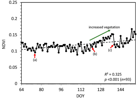
Figure 5.
Daily NDVI values during the study period. (a), (b), and (c) correspond to the events shown in Figure 6a–c, respectively.
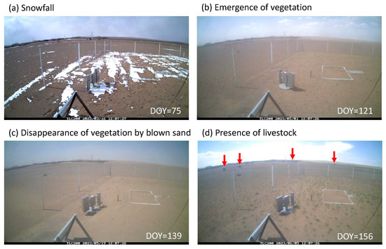
Figure 6.
Time-lapse camera images of the landscape. (a) A snow event, (b) emergence of vegetation, (c) blown sand, and (d) livestock. (a–c) correspond with (a–c) in Figure 4.
3.2. Soil Water Content and Moisture Index Based on Land Surface Temperature
Figure 7a shows the daily values of SWC and MIST. Both significantly increased (p < 0.001) during the study period due to rainfall events that began in mid-April. MIST decreased as SWC increased and was significantly correlated with SWC (p < 0.001, Figure 7b). There was greater variability (0.043 ± 0.008) when SWC was less than 3% (i.e., when it was extremely dry). Since there may be a limit of the measurement accuracy (±1 to 2%) in the SWC sensor itself, it is difficult to determine the causes of variability in MIST values.
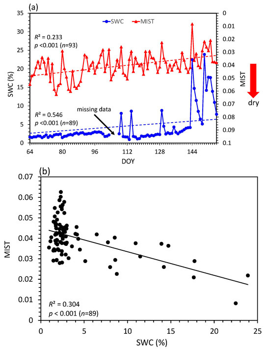
Figure 7.
(a) Daily SWC and MIST values; (b) relationship between SWC and MIST.
3.3. Saltation Number
Figure 8 shows the daily values of the saltation number at 35 cm and the maximum wind speed WSmax at 10 m (by Equation (4)). The saltation number at 35 cm was used because the number of observations exceeded the maximum that could be recorded by the data logger (2,147,483,647) during heavy sandstorm events at other heights (8 cm and 11 cm).
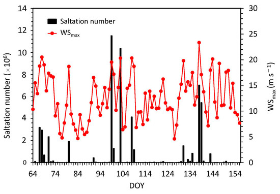
Figure 8.
Daily saltation number at 35 cm and maximum wind speed at 10 m.
Past studies have defined the threshold wind speed at 10 m height for wind erosion to be 7 m s−1 [41]; therefore, a maximum wind speed of greater than 7 m s−1 as a “strong wind speed” was used. There were only 11 days when the maximum daily wind speed was less than 7 m s−1. Therefore, there was a strong wind on most days during the study period.
According to ref. [42], the duration of a typical blown sand event in Mongolia is about 1 h (hour). During the study period, a typical event had a saltation number of greater than 4 × 10⁵ (Figure 8). Thus, if the saltation number exceeded 4 × 10⁵, it was defined as a “blown sand event.” Sixteen blown sand events were detected during the study period. Furthermore, when a blown sand event continued for more than 6 h, it was defined as “sandstorm event” [42], which corresponded to a saltation number of greater than 2 × 10⁶. In total, 8 sandstorm events were detected, and a wind speed >15 m s−1 was confirmed in all events (Figure 8).
Figure 9a shows the relationship between SWC and saltation number. A total of 16 blown sand events occurred when the SWC was less than 5%. It should be noted that the saltation numbers were very small when the SWC exceeded 5%.
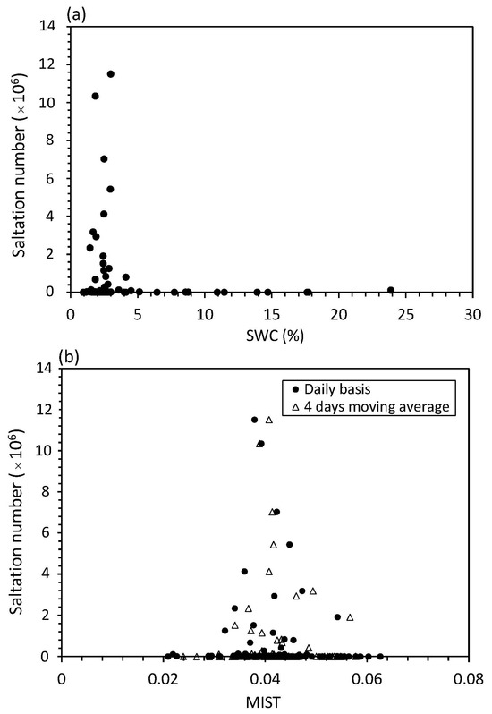
Figure 9.
Relationship between the saltation number at 35 cm and (a) SWC and (b) MIST.
Figure 9b shows the relationship between MIST and saltation number. Of the 16 blown sand events, 10 occurred when MIST exceeded 0.039 (which corresponds to SWC = 5%, Figure 7b). The accuracy rate of using MIST to detect blown sand events was 63%; this value is relatively low, most likely because MIST values varied when SWC was less than 3% (Section 3.2). However, the accuracy rate increased to 81% (13 of 16 events) when the 4-day moving average of MIST was used (Figure 9b).
4. Discussion
Regarding NDVI based on remote sensing, detecting daily changes in land surface conditions can be difficult only using satellite observations, which can be affected by cloud cover. Combining the use of visible images and ground-based NDVI is therefore an advantage. In addition, visible images may also be useful to determine other factors, such as the effect of regional grazing pressure by allowing the number of livestock to be counted (Figure 6d) [43,44].
Past studies indicated that an NDVI of 0.2 was the threshold for the occurrence of blown sand and dust [10]. Figure 5 shows that the value of NDVI was consistently less than 0.2 during the study period, indicating that blown sand events were likely to occur. Ref. [10] showed that the saltation number decreased logarithmically with increasing NDVI when the NDVI was less than 0.2.
Past studies have found that wind erosion seldom occurs when the surface SWC exceeds 5% [45] and have indicated that the saltation number is high when the soil moisture is 2–6% but very low (approaching zero) for SWC greater than 6% [12]. Previous studies have also reported that the effect of wind erosion is minimal when the surface SWC exceeds 2–6% [16,46,47,48,49]. The obtained results were in accordance with the results of these studies.
MIST has the advantage of using a more realistic LST amplitude compared to SbAI. The R2 and p values from the relationship between SbAI and SWC were 0.095 and 0.003, respectively; thus, accuracy was improved in MIST (Figure 7b).
The standard deviation of the error of estimation of SWC derived from MIST using the regression line in Figure 7b was ±3.9% in the overall SWC. Past studies have estimated the thermal inertia of the land surface calculated from LST, a complex heat balance model, and meteorological data [19]. They have suggested that their model has the potential to estimate subsurface SWC within ±3–4% of the daily observed SWC, which is accurate enough to roughly classify thermal inertia estimates into a few levels of SWC (e.g., wet, middle, and dry) [19]. The estimated error was close to theirs, which was estimated using a more complex model, and their rough classification will serve as a useful reference for MIST.
Although the number of observations at 8 cm and 11 cm exceeded the maximum recorded number by the data logger (2,147,483,647) during blown sand events, the vertical profile of the daily saltation number when the sandstorm occurred is shown as an example (DOY = 68, 99, 103, and 138) (Figure 10). The saltation numbers were the largest at 8 cm and 11 cm and almost the same at other heights. The vertical profile of the saltation number was very close to the results in mass flux having their peak around 10 cm over transverse dunes by wind tunnel experiment and numerical simulations [50]. The results indicated that the windward slope gradient played a great role in the lift-off and sand particle saltation. In fact, our station was not a flat surface, as shown in Figure 2 and Figure 6. Regardless, the problem of recorded number by the data logger should be improved to monitor the accurate vertical profile of the saltation number.
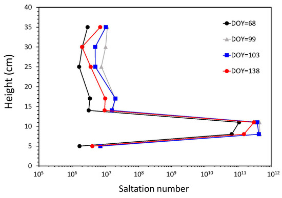
Figure 10.
Daily saltation number at each height when the sandstorm occurred.
5. Conclusions and Expectations
Numerical simulations of the future climate indicate that arid regions, including northeast Asia, will see more droughts and desertification. In this study, a monitoring system focusing on regional wind erosion was introduced, and data collected during the Asian dust season (March to May 2023) in Mongolia were analyzed. The system was composed of instruments that observed blown sand, amount of vegetation, land surface wetness, and landscape features related to wind erosion. The following can be stated as highlights of this study:
- Combining the use of visible images and NDVI was an advantage by detecting daily changes in vegetation conditions, like the emergence of vegetation. Since NDVI based on satellite observations cannot detect them diurnally due to the effects of cloud cover, combining the use of visible images and ground-based NDVI is an advantage to monitor the present land surface conditions. For example, it could help in the management of livestock numbers and vegetation conditions to reduce overgrazing.
- The MIST index for land surface wetness was newly introduced to evaluate blown sand events. Although the accuracy of MIST was not good in extremely dry conditions, blown sand events can be qualitatively determined by applying statistical processing (e.g., using a multi-day moving average) to the index. Visible images were useful to confirm various events related to land surface wetness, such as snowfall, rainfall, and blown sand. As with NDVI, LST based on satellite observations is affected by cloud cover; thus, combining the use of visible images and ground-based MIST is an advantage to monitor the present land surface wetness.
- The most important instrument in this system was the newly developed instrument to measure blown sand. Sixteen blown sand and eight sandstorm events were detected by results at 35 cm during the study period. The vertical profile of the saltation number showed that the largest numbers were found at 8 cm and 11 cm. In the past, such a dense interval measurement within 35 cm could not be seen in the actual field, so future development is expected that will enable additional physical knowledge of wind erosion to be obtained by accumulating actual field data.
- Combining the results of NDVI, MIST, and blown sand, it was concluded that the land surface in Khuld was most likely undergoing wind erosion during the study period. It is necessary, however, to accumulate continuous data on the relationship between land surface conditions and wind erosion to prevent its progress.
Because this system is comparatively simple and low cost, building it alongside weather stations will make it possible to monitor wind erosion in Mongolia. In addition, the system should strengthen WMO synoptic observations to monitor sandstorms and Asian dust because dust emissions are proportional to the occurrence of saltation. Additional observation results have to be accumulated throughout Mongolia to construct a reliable system.
Author Contributions
Conceptualization, R.K.; methodology, R.K., J.L. and M.M.; formal analysis, R.K., J.L. and M.M.; investigation, R.K., J.L. and U.G.; writing—original draft preparation, R.K.; writing—review and editing, R.K.; funding acquisition, R.K. All authors have read and agreed to the published version of the manuscript.
Funding
This research was funded by a Grant-in-Aid for Scientific Research, grant number KAKENHI 19H04239.
Data Availability Statement
The original contributions presented in the study are included in the paper, and further inquiries can be directed to the corresponding author.
Acknowledgments
The authors thank Matsushima for supporting our field observations, Nandintsetseg for providing precipitation data, and the valuable comments from three reviewers.
Conflicts of Interest
The authors declare no conflicts of interest.
References
- IPCC. Climate Change: The Physical Science Basis; Contribution of working group I to the sixth assessment report of the intergovernmental panel on climate change; IPCC: Geneva, Switzerland, 2021; In press. [Google Scholar]
- Dai, A.G. Drought under global warming: A review. Wiley Interdiscip. Rev. Clim. Chang. 2011, 2, 45–65. [Google Scholar] [CrossRef]
- Koutroulis, A.G. Dryland changes under different levels of global warming. Sci. Total. Environ. 2019, 655, 482–511. [Google Scholar] [CrossRef]
- Tsunekawa, A. Knowledge and Technology to Save Drylands—Solutions to Desertification, Land Degradation and Drought; Maruzen Publishing: Tokyo, Japan, 2014; p. 153. [Google Scholar]
- Ishikawa, Y. Present situation of desertification. J. Arid. Land. Stud. 2020, 30, 19–26. [Google Scholar]
- UNEP. World Atlas of Desertification; Arnold: London, UK, 1997; p. 182. [Google Scholar]
- Cherlet, M.; Hutchinson, C.; Reynolds, J.; Hill, J.; Sommer, S.; Von Maltitz, G. World Atlas of Desertification; Publication Office of the European Union: Luxembourg, 2018; p. 248. [Google Scholar]
- Kimura, R.; Moriyama, M. Determination by MODIS satellite-based methods of recent global trends in land surface aridity and degradation. J. Agric. Meteorol. 2019, 75, 153–159. [Google Scholar] [CrossRef]
- Shinoda, M. Desert and Climate; Seizandou Publishing: Tokyo, Japan, 2002; p. 169. [Google Scholar]
- Kimura, R.; Shinoda, M. Spatial distribution of threshold wind speeds for dust outbreaks in northeast Asia. Geomorphology. 2010, 114, 319–325. [Google Scholar] [CrossRef]
- Abulaiti, A.; Kimura, R.; Shinoda, M. Vegetation effects on saltation flux in a grassland of Mongolia. Sand Dune Res. 2013, 59, 117–128. [Google Scholar]
- Abulaiti, A.; Kimura, R.; Shinoda, M.; Kurosaki, Y.; Mikami, M.; Ishizuka, M.; Yamada, Y.; Nishihara, E.; Gantsetseg, B. An observational study of saltation and dust emission in a hotspot of Mongolia. Aeolian Res. 2014, 15, 169–176. [Google Scholar] [CrossRef]
- Wang, T. Deserts and Aeolian Desertification in China; Science Press: Beijing, China, 2011; p. 819. [Google Scholar]
- Wang, T. Aeolian desertification and its control in Northern China. Int. Soil Water Conserv. Res. 2014, 2, 34–41. [Google Scholar]
- Kimura, R. Recent climatological conditions and land degradation in drylands. J. Arid. Land. Stud. 2022, 31, 102–108. [Google Scholar]
- Shao, Y. Physics and modelling of wind erosion. In Atmospheric and Oceanographic Sciences Library; Kluwer Academic Press: Dordrecht, The Netherlands, 2000; Volume 23, p. 393. [Google Scholar]
- Kimura, R.; Bai, L.; Wang, J. Relationships among dust outbreaks, vegetation cover, and surface soil water content on the Loess Plateau of Chia, 1999–2000. Catena 2009, 77, 292–296. [Google Scholar] [CrossRef]
- Kimura, R. Interannual changes of land surface conditions in Asian dust source regions since 2000. J. Agric. Meteorol. 2022, 78, 174–181. [Google Scholar] [CrossRef]
- Matsushima, D.; Kimura, R.; Shinoda, M. Soil moisture estimation using thermal inertia: Potential and sensitivity to data conditions. J. Hydrometeorol. 2012, 13, 638–648. [Google Scholar] [CrossRef]
- Bakhtiari, M.; Boloorani, A.D.; Kakroodi, A.A.; Rangzan, K.; Mousivand, A. Land degradation modeling of dust storm sources using MODIS and meteorological time series data. J. Arid. Environ. 2021, 190, 104507. [Google Scholar] [CrossRef]
- Kimura, R.; Moriyama, M. Application of a satellite-based aridity index in dust source regions of northeast Asia. J. Arid. Environ. 2014, 109, 31–38. [Google Scholar] [CrossRef]
- Shao, Y.; Mikami, M. Heterogeneous saltation: Theory, observation and comparison. Bound-Lay. Meteorol. 2005, 115, 359–379. [Google Scholar] [CrossRef]
- Fujita, N.; Kato, S.; Kusano, E. Mongolia; Kyoto University Press: Kyoto, Japan, 2013; p. 685. [Google Scholar]
- Kimura, R.; Moriyama, M. Use of a MODIS satellite-based aridity index to monitor drought conditions in Mongolia from 2001 to 2013. Remote. Sens. 2021, 13, 2561. [Google Scholar] [CrossRef]
- Dagys, K.; Agipar, B.; Tsolmon, S.; Ringler, C.; Bellisario, K.; Fanzo, J. Maximizing nutrition in key food value chains of Mongolia under climate change. Food Policy 2023, 117, 102468. [Google Scholar] [CrossRef]
- Hosaka, K.; Ugai, M.; Kubota, S.; Oguri, Y. Experiment for wind blown sand using a ceramics piezo-electric sensor. Proc. Civ. Eng. Ocean 2004, 20, 1091–1096. [Google Scholar] [CrossRef]
- Udo, K. Field observations of aeolian sand transport rate using a piezoelectric ceramic sensor. Proc. Coastal Eng. 2008, 55, 551–555. [Google Scholar] [CrossRef]
- Liu, J.; Kimura, R. Wind speed characteristics and blown sand flux over a gravel surface in a compact wind tunnel. Aeolian Res. 2018, 35, 39–46. [Google Scholar] [CrossRef]
- Liu, J.; Kimura, R.; Miyawaki, M. Effects of plants with different shapes and coverage on the blown-sand flux and roughness length examined by wind tunnel experiments. Catena 2021, 197, 104976. [Google Scholar] [CrossRef]
- Liu, J.; Wu, J.; Kimura, R. Evaluating the sand-trapping efficiency of sand fences using a combination of wind-blown sand measurements and UAV photogrammetry at Tottori sand dunes, Japan. Remote. Sens. 2023, 15, 1098. [Google Scholar] [CrossRef]
- Sharp, R.P. Wind-driven sand in Coachella Valley, California-Further Data. Geol. Soc. Am. Bull. 1980, 91, 724–730. [Google Scholar] [CrossRef]
- Wu, Z. Aeolian Geomorphology; Science Press: Beijing, China, 1987; p. 316. [Google Scholar]
- Fryrear, D.W. A field dust sampler. J. Soil. Water Conserv. 1986, 41, 117–120. [Google Scholar]
- Stockton, P.; Gillette, D. Field measurement of the sheltering effect of vegetation on erodible land surfaces. Land. Degrad. Dev. 1990, 2, 77–85. [Google Scholar] [CrossRef]
- Mikami, M.; Yamada, Y.; Ishizuka, M.; Ishimaru, T.; Gao, W.; Zeng, F. Measurement of saltation process over Govi and sand dunes in the Taklamakan Desert, China, with newly developed sand particle counter. J. Geophys. Res. 2005, 110, D18S02. [Google Scholar]
- Kimura, R. Wind condition and blown sand in Tottori sand dunes. In Tottori Sand Dunes; Kodama, Y., Nagamatsu, D., Takata, K., Eds.; Kokon Shoin: Tokyo, Japan, 2017; pp. 16–23. [Google Scholar]
- Oke, T.R. Boundary Layer Climates; Methuen & Co Ltd.: New York, NY, USA, 1978; p. 372. [Google Scholar]
- Bauer, B.O.; Davidson-Arnott, R.G.D.; Hesp, P.A.; Namikas, S.L.; Ollerhead, J.; Walker, I.J. Aeolian sediment transport on a beach: Surface moisture, wind fetch, and mean transport. Geomorphology 2009, 105, 106–116. [Google Scholar] [CrossRef]
- Guo, Z.; Li, J.; Chang, C.; Zou, X.; Wang, R.; Zhou, N.; Li, Q. Logistic growth models for describing the fetch effect of aeolian sand transport. Soil. Tillage Res. 2019, 194, 104306. [Google Scholar] [CrossRef]
- Kondo, J. Meteorology of the Water Environment; Asakura Shoten: Tokyo, Japan, 1994; p. 327. [Google Scholar]
- Yamamoto, T.; Yoshino, M.; Suzuki, J. The relationship between occurrence of dust events and synoptic climatological condition in East Asia, 1999–2003. J. Meteorol. Soc. Jpn. 2007, 85, 81–99. [Google Scholar] [CrossRef][Green Version]
- Iwasaka, Y.; Nishikawa, M.; Yamada, M.; Hong, C.S. KOSA; Kokon Shoin Press: Tokyo, Japan, 2009; p. 342. [Google Scholar]
- Nakano, T.; Bavuudorj, G.; Iijima, Y.; Ito, T.Y. Quantitative evaluation of grazing effect on nomadically grazed grassland ecosystems by using time-lapse cameras. Agr. Ecosyst. Environ. 2020, 287, 106685. [Google Scholar] [CrossRef]
- Mücher, C.A.; Los, S.; Franke, G.J.; Kamphuis, C. Detection, identification and posture recognition of cattle with satellites, aerial photography and UAVs using deep learning techniques. Int. J. Remote Sens. 2022, 43, 2377–2392. [Google Scholar] [CrossRef]
- Wu, Z. Geomorphology of Wind-Drift Stands and Their Controlled Engineering; Science Press: Beijing, China, 2003; p. 448. [Google Scholar]
- Bisal, F.; Hsieh, J. Influence of moisture on the erodibility of soil by wind. Soil. Sci. 1966, 102, 143–146. [Google Scholar] [CrossRef]
- Nickling, W.G. Aeolian sediment transport during dust storms: Slims river valley, Yukon Territory. Can. J. Earth Sci. 1978, 15, 1069–1084. [Google Scholar] [CrossRef]
- Logie, M. Influence of roughness elements and soil moisture on the resistance of sand to wind erosion. Catena Suppl. 1982, 1, 161–173. [Google Scholar]
- Abulaiti, A.; Kimura, R. Characteristics of the sand drifting of Tottori sand dune in springtime. Sand Dune Res. 2011, 58, 31–40. [Google Scholar]
- Jiang, H.; Huang, N.; Zhu, Y. Analysis of Wind-blown Sand Movement over Transverse Dunes. Sci. Rep. 2014, 4, 7114. [Google Scholar] [CrossRef]
Disclaimer/Publisher’s Note: The statements, opinions and data contained in all publications are solely those of the individual author(s) and contributor(s) and not of MDPI and/or the editor(s). MDPI and/or the editor(s) disclaim responsibility for any injury to people or property resulting from any ideas, methods, instructions or products referred to in the content. |
© 2024 by the authors. Licensee MDPI, Basel, Switzerland. This article is an open access article distributed under the terms and conditions of the Creative Commons Attribution (CC BY) license (https://creativecommons.org/licenses/by/4.0/).