


Mapping Irrigated Rice in Brazil Using Sentinel-2 Spectral–Temporal Metrics and Random Forest Algorithm


Abstract

1. Introduction
2. Materials and Methods
2.1. Study Region
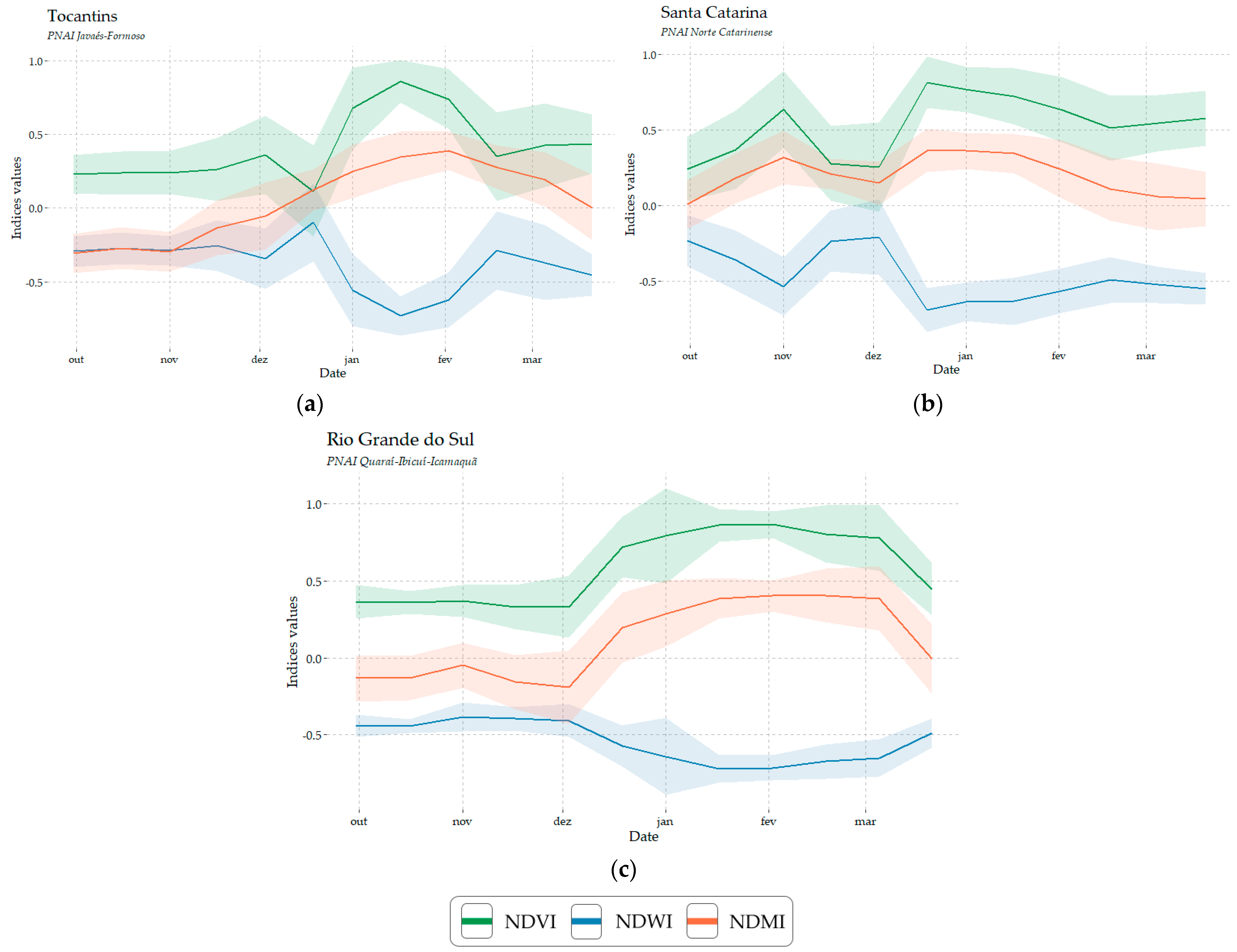
2.1.1. Tocantins
2.1.2. Santa Catarina
2.1.3. Rio Grande do Sul
2.2. Reference Data
2.3. Remote Sensing Data
2.4. Time Series Extraction and STM Generation
2.5. Classification
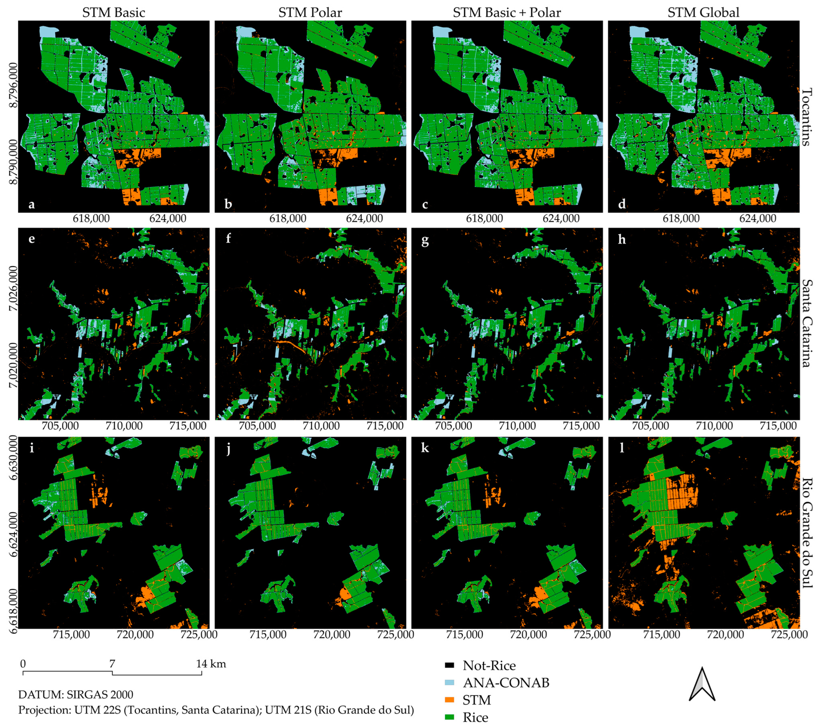
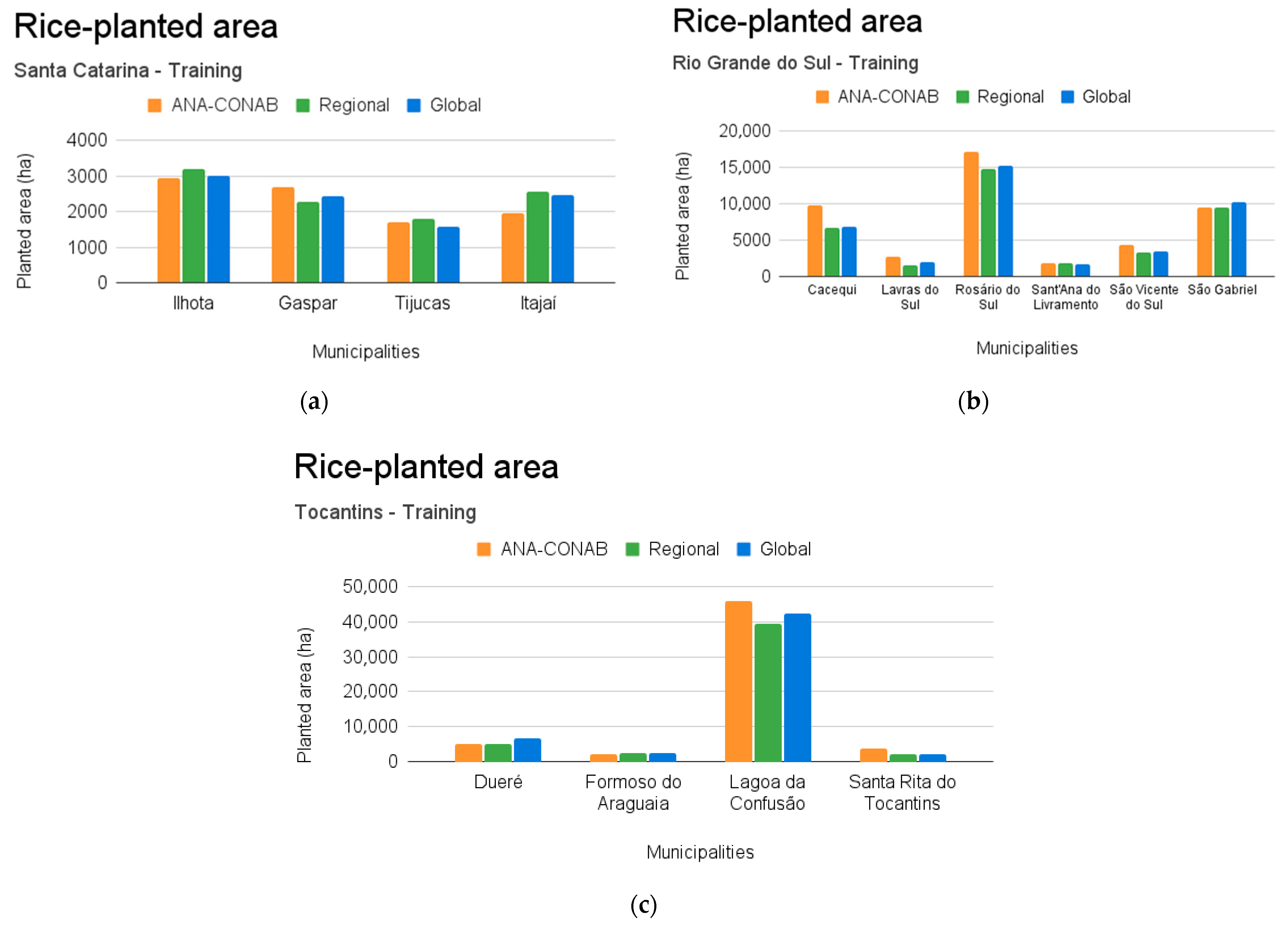
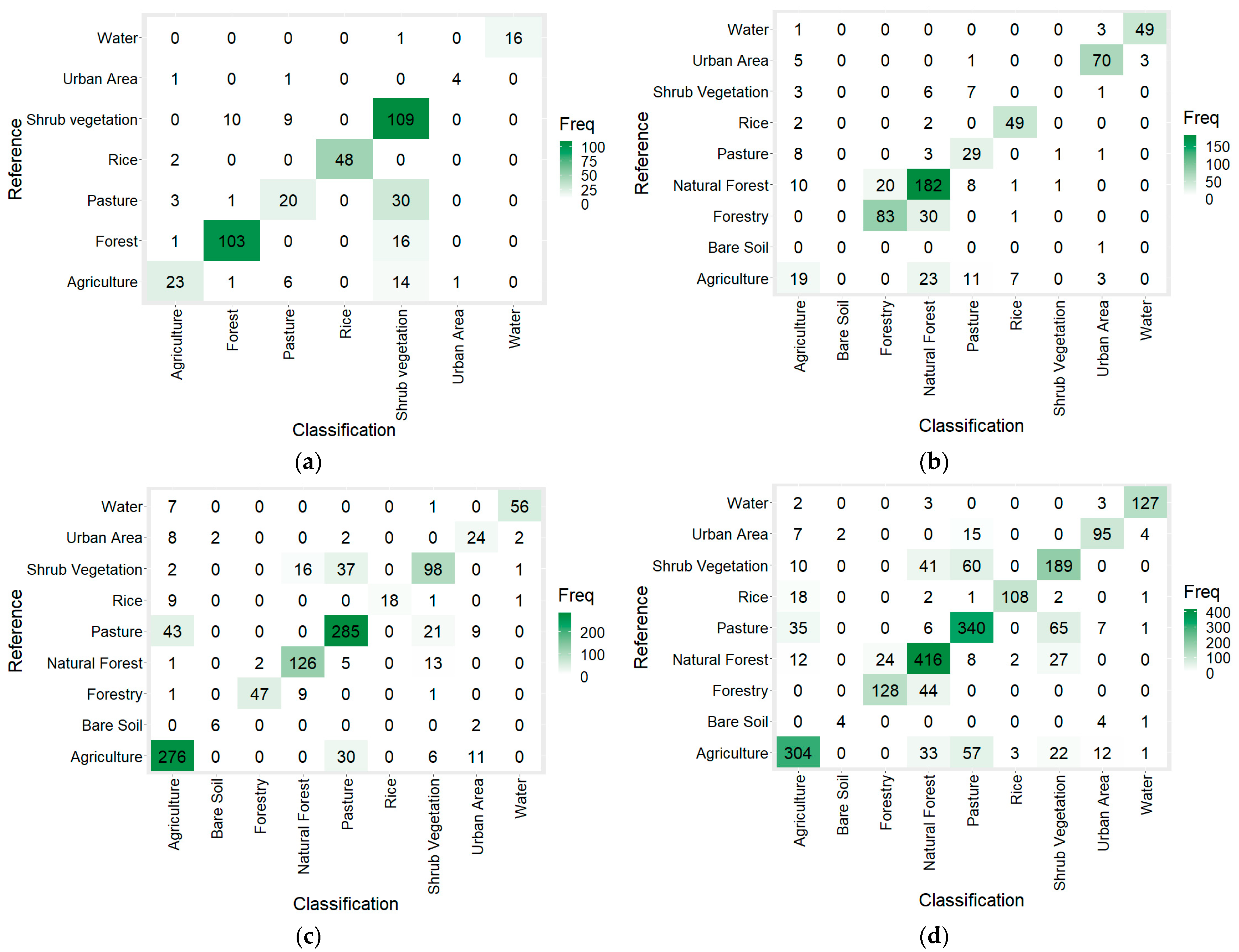
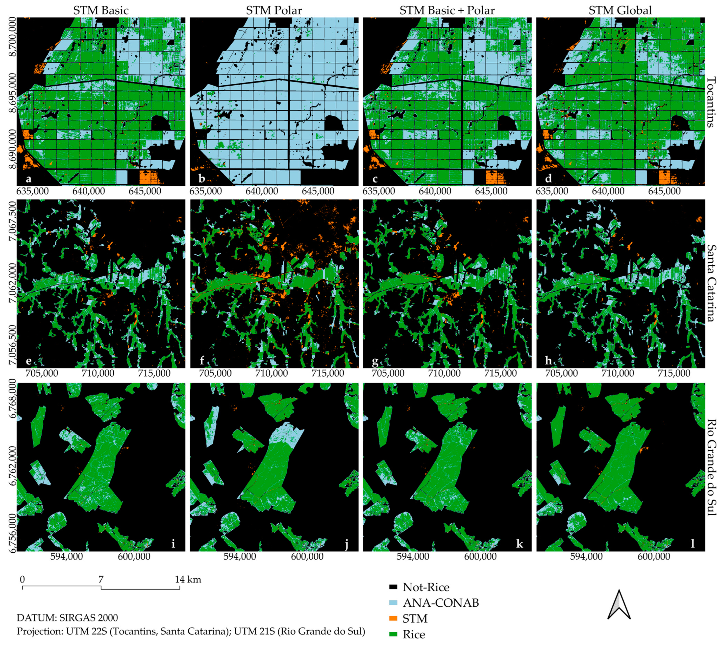
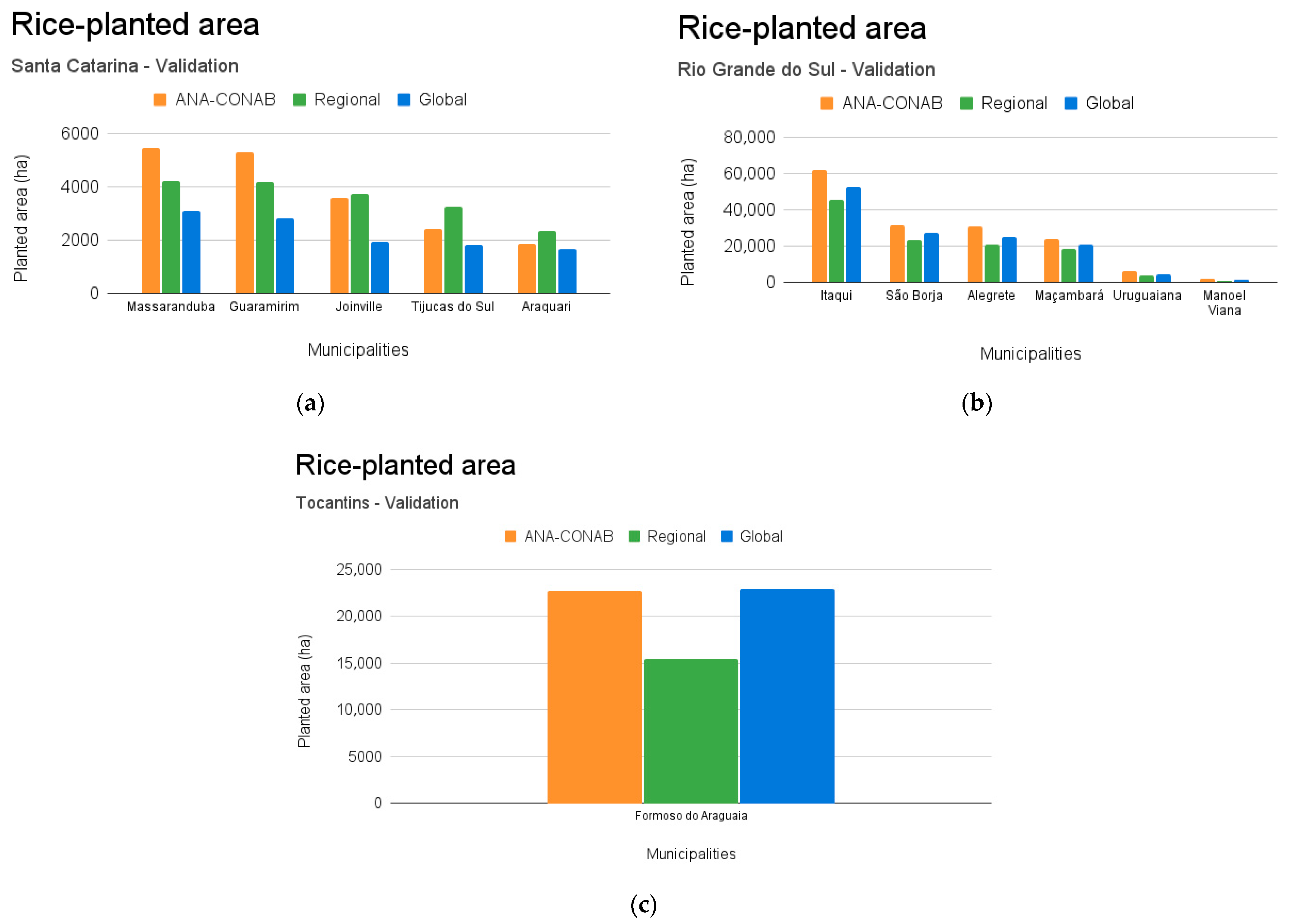
3. Results
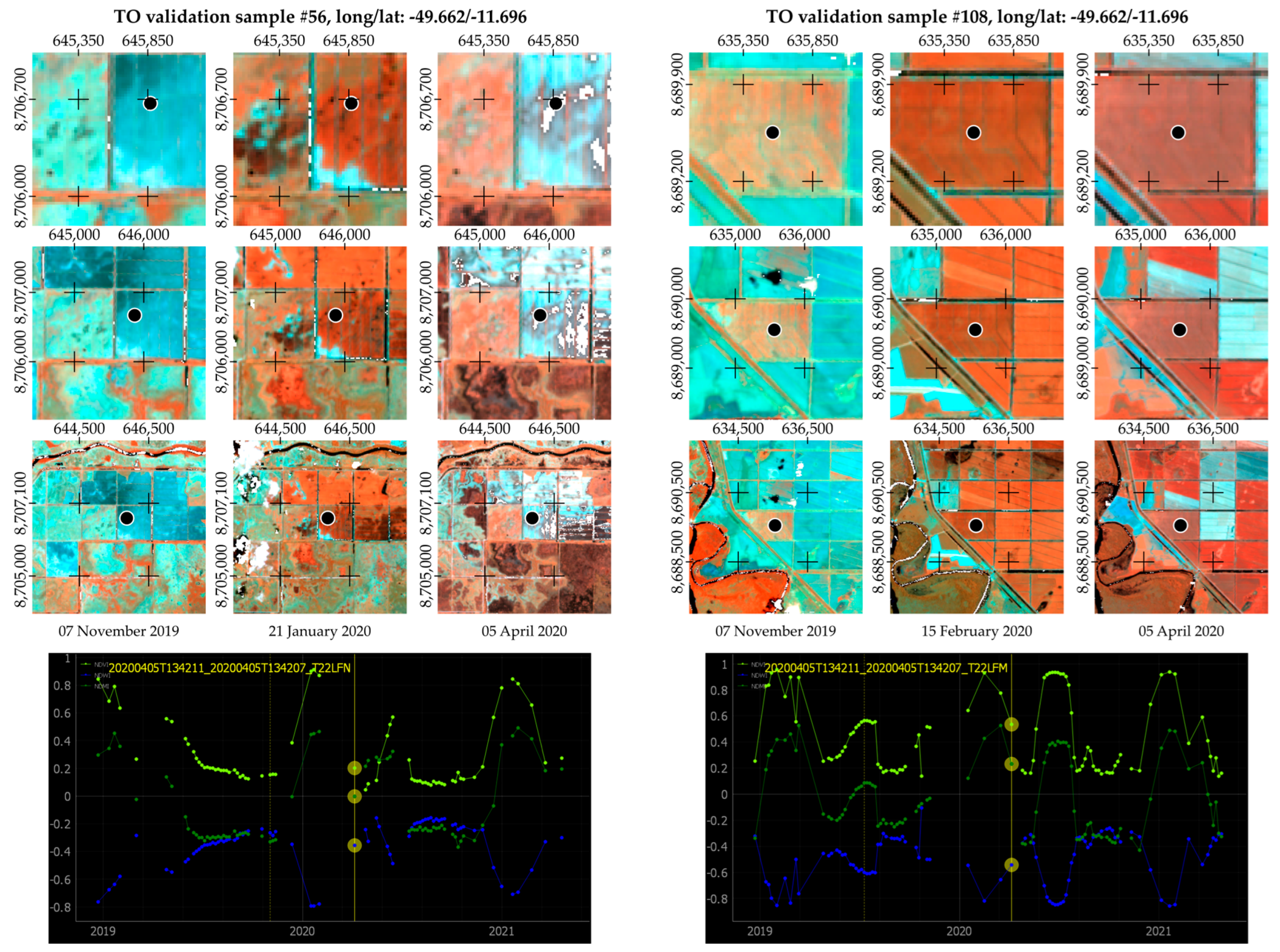
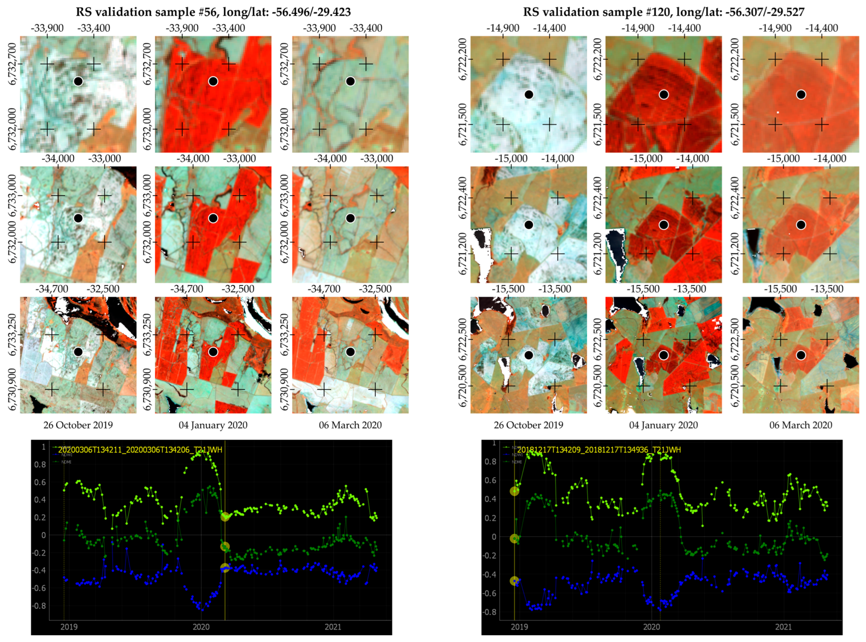
3.1. Spectral–Temporal Profile for Rice
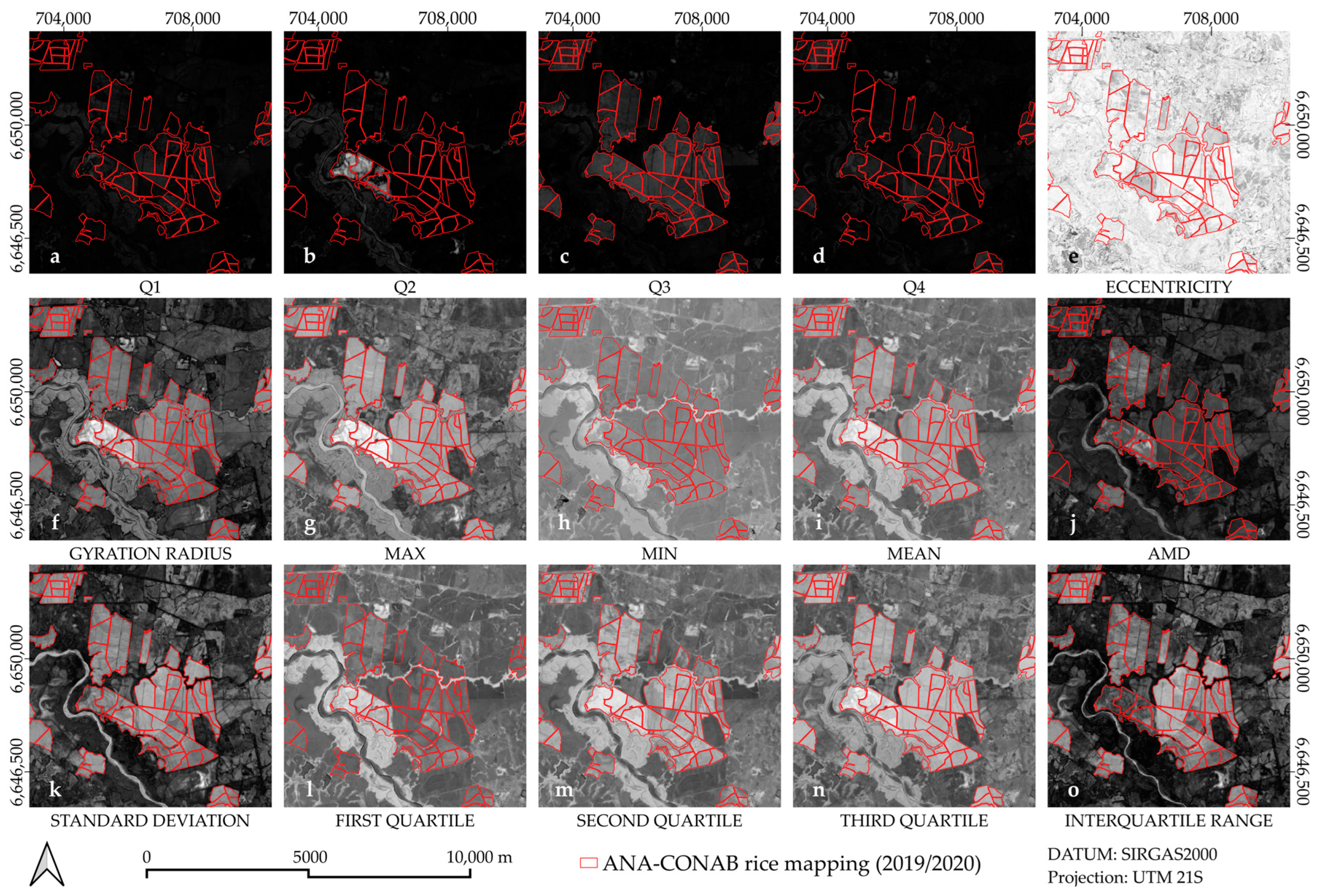
3.2. STM from Spectral Indices
3.3. Classification
4. Discussion
4.1. Relevant Contributions of This Study
4.2. Limitations and Future Works
5. Conclusions
Author Contributions
Funding
Data Availability Statement
Acknowledgments
Conflicts of Interest
Appendix A

References
- Agência Nacional de Águas e Saneamento Básico (ANA). Mapeamento Do Arroz Irrigado No Brasil; ANA: Brasília, Brazil, 2020. [Google Scholar]
- Rodrigues, R.M.; Souza, A.D.M.; Bezerra, I.N.; Pereira, R.A.; Yokoo, E.M.; Sichieri, R. Most Consumed Foods in Brazil: Evolution between 2008–2009 and 2017–2018. Rev. Saude Publica 2021, 55, 4s. [Google Scholar] [CrossRef] [PubMed]
- Sociedade Sul-Brasileira de Arroz Irrigado. Arroz Irrigado: Recomendações Técnicas Da Pesquisa Para o Sul Do Brasil; Sociedade Sul-Brasileira de Arroz Irrigado: Cachoeirinha, Brazil, 2018; ISBN 978-85-54856-29-8. [Google Scholar]
- Laborte, A.G.; Gutierrez, M.A.; Balanza, J.G.; Saito, K.; Zwart, S.J.; Boschetti, M.; Murty, M.V.R.; Villano, L.; Aunario, J.K.; Reinke, R.; et al. RiceAtlas, a Spatial Database of Global Rice Calendars and Production. Sci. Data 2017, 4, 170074. [Google Scholar] [CrossRef] [PubMed]
- Bendini, H.N.; Garcia Fonseca, L.M.; Schwieder, M.; Sehn Körting, T.; Rufin, P.; Del Arco Sanches, I.; Leitão, P.J.; Hostert, P. Detailed Agricultural Land Classification in the Brazilian Cerrado Based on Phenological Information from Dense Satellite Image Time Series. Int. J. Appl. Earth Obs. Geoinf. 2019, 82, 101872. [Google Scholar] [CrossRef]
- Formaggio, A.R.; Sanches, I.D. Sensoriamento Remoto em Agricultura; Oficina de Textos: São Paulo, Brazil, 2017; ISBN 978-85-7975-282-7. [Google Scholar]
- Companhia Nacional de Abastecimento (CONAB). Série Histórica Da Safra de Arroz 2023. Available online: https://www.conab.gov.br/info-agro/safras/serie-historica-das-safras/itemlist/category/900-arroz (accessed on 14 August 2023).
- de Magalhães, A.M., Jr.; Gomes, A.D.S.; dos Santos, A.B. Sistema de Cultivo de Arroz Irrigado No Brasil; Sistemas de Produção; Embrapa Clima Temperado: Pelotas, Brazil, 2004; p. 270. [Google Scholar]
- EMBRAPA, Empresa Brasileira de Pesquisa Agropecuária. Cultivo Do Arroz. Available online: https://www.embrapa.br/en/agencia-de-informacao-tecnologica/cultivos/arroz (accessed on 16 October 2023).
- Ferreira, K.R.; Queiroz, G.R.; Vinhas, L.; Marujo, R.F.B.; Simões, R.E.O.; Picoli, M.C.A.; Camara, G.; Cartaxo, R.; Gomes, V.C.F.; Santos, L.A.; et al. Earth Observation Data Cubes for Brazil: Requirements, Methodology and Products. Remote Sens. 2020, 12, 4033. [Google Scholar] [CrossRef]
- Körting, T.S.; Garcia Fonseca, L.M.; Câmara, G. GeoDMA-Geographic Data Mining Analyst. Comput. Geosci. 2013, 57, 133–145. [Google Scholar] [CrossRef]
- He, Y.; Dong, J.; Liao, X.; Sun, L.; Wang, Z.; You, N.; Li, Z.; Fu, P. Examining Rice Distribution and Cropping Intensity in a Mixed Single- and Double-Cropping Region in South China Using All Available Sentinel 1/2 Images. Int. J. Appl. Earth Obs. Geoinf. 2021, 101, 102351. [Google Scholar] [CrossRef]
- He, Z.; Li, S.; Chang, M.; Liu, Y.; Liu, K.; Wan, L.; Wang, Y. Novel Harmonic-Based Scheme for Mapping Rice-Crop Intensity at a Large Scale Using Time-Series Sentinel-1 and ERA5-Land Datasets. IEEE Trans. Geosci. Remote Sens. 2024, 62, 1–23. [Google Scholar] [CrossRef]
- Som-ard, J.; Immitzer, M.; Vuolo, F.; Ninsawat, S.; Atzberger, C. Mapping of Crop Types in 1989, 1999, 2009 and 2019 to Assess Major Land Cover Trends of the Udon Thani Province, Thailand. Comput. Electron. Agric. 2022, 198, 107083. [Google Scholar] [CrossRef]
- You, N.; Dong, J.; Huang, J.; Du, G.; Zhang, G.; He, Y.; Yang, T.; Di, Y.; Xiao, X. The 10-m Crop Type Maps in Northeast China during 2017–2019. Sci. Data 2021, 8, 41. [Google Scholar] [CrossRef]
- Karthikeyan, L.; Chawla, I.; Mishra, A.K. A Review of Remote Sensing Applications in Agriculture for Food Security: Crop Growth and Yield, Irrigation, and Crop Losses. J. Hydrol. 2020, 586, 124905. [Google Scholar] [CrossRef]
- Bem, P.P.; de Carvalho Júnior, O.A.; de Carvalho, O.L.F.; Gomes, R.A.T.; Guimarāes, R.F.; Pimentel, C.M.M. Irrigated Rice Crop Identification in Southern Brazil Using Convolutional Neural Networks and Sentinel-1 Time Series. Remote Sens. Appl. Soc. Environ. 2021, 24, 100627. [Google Scholar] [CrossRef]
- de Castro Filho, H.C.; de Carvalho, O.A., Jr.; de Carvalho, O.L.F.; de Bem, P.P.; de Moura, R.D.S.; de Albuquerque, A.O.; Silva, c.R.; Guimaraes Ferreira, P.H.; Guimaraes, R.F.; Trancoso Gomes, R.A. Rice Crop Detection Using LSTM, Bi-LSTM, and Machine Learning Models from Sentinel-1 Time Series. Remote Sens. 2020, 12, 2655. [Google Scholar] [CrossRef]
- D’Arco, E.; Alvarenga, B.S.; Rizzi, R.; Rudorff, B.F.T.; Moreira, M.A.; Adami, M. Geotecnologias na Estimativa da Área Plantada Com Arroz Irrigado. Rev. Bras. Cartogr. 2009, 58, 247–253. [Google Scholar] [CrossRef]
- Dong, J.; Xiao, X.; Kou, W.; Qin, Y.; Zhang, G.; Li, L.; Jin, C.; Zhou, Y.; Wang, J.; Biradar, C.; et al. Tracking the Dynamics of Paddy Rice Planting Area in 1986–2010 through Time Series Landsat Images and Phenology-Based Algorithms. Remote Sens. Environ. 2015, 160, 99–113. [Google Scholar] [CrossRef]
- Dong, J.; Xiao, X.; Menarguez, M.A.; Zhang, G.; Qin, Y.; Thau, D.; Biradar, C.; Moore, B. Mapping Paddy Rice Planting Area in Northeastern Asia with Landsat 8 Images, Phenology-Based Algorithm and Google Earth Engine. Remote Sens. Environ. 2016, 185, 142–154. [Google Scholar] [CrossRef] [PubMed]
- Dong, J.; Xiao, X. Evolution of Regional to Global Paddy Rice Mapping Methods: A Review. ISPRS J. Photogramm. Remote Sens. 2016, 119, 214–227. [Google Scholar] [CrossRef]
- Kontgis, C.; Schneider, A.; Ozdogan, M. Mapping Rice Paddy Extent and Intensification in the Vietnamese Mekong River Delta with Dense Time Stacks of Landsat Data. Remote Sens. Environ. 2015, 169, 255–269. [Google Scholar] [CrossRef]
- Pott, L.P.; Amado, T.J.C.; Schwalbert, R.A.; Corassa, G.M.; Ciampitti, I.A. Satellite-Based Data Fusion Crop Type Classification and Mapping in Rio Grande Do Sul, Brazil. ISPRS J. Photogramm. Remote Sens. 2021, 176, 196–210. [Google Scholar] [CrossRef]
- Xiao, X.; Hollinger, D.; Aber, J.; Goltz, M.; Davidson, E.A.; Zhang, Q.; Moore, B. Satellite-Based Modeling of Gross Primary Production in an Evergreen Needleleaf Forest. Remote Sens. Environ. 2004, 89, 519–534. [Google Scholar] [CrossRef]
- Zhao, R.; Li, Y.; Ma, M. Mapping Paddy Rice with Satellite Remote Sensing: A Review. Sustainability 2021, 13, 503. [Google Scholar] [CrossRef]
- Kuenzer, C.; Knauer, K. Remote Sensing of Rice Crop Areas. Int. J. Remote Sens. 2013, 34, 2101–2139. [Google Scholar] [CrossRef]
- Saini, P.; Nagpal, B. Spatiotemporal Landsat-Sentinel-2 Satellite Imagery-Based Hybrid Deep Neural Network for Paddy Crop Prediction Using Google Earth Engine. Adv. Space Res. 2024, 73, 4988–5004. [Google Scholar] [CrossRef]
- Sun, L.; Yang, T.; Lou, Y.; Shi, Q.; Zhang, L. Paddy Rice Mapping Based on Phenology Matching and Cultivation Pattern Analysis Combining Multi-Source Data in Guangdong, China. J. Remote Sens. 2024, 0152. [Google Scholar] [CrossRef]
- Qiu, B.; Yu, L.; Yang, P.; Wu, W.; Chen, J.; Zhu, X.; Duan, M. Mapping Upland Crop–Rice Cropping Systems for Targeted Sustainable Intensification in South China. Crop J. 2024, 12, 614–629. [Google Scholar] [CrossRef]
- Ofori-Ampofo, S.; Pelletier, C.; Lang, S. Crop Type Mapping from Optical and Radar Time Series Using Attention-Based Deep Learning. Remote Sens. 2021, 13, 4668. [Google Scholar] [CrossRef]
- Appel, M.; Pebesma, E. On-Demand Processing of Data Cubes from Satellite Image Collections with the Gdalcubes Library. Data 2019, 4, 92. [Google Scholar] [CrossRef]
- Lewis, A.; Oliver, S.; Lymburner, L.; Evans, B.; Wyborn, L.; Mueller, N.; Raevksi, G.; Hooke, J.; Woodcock, R.; Sixsmith, J.; et al. The Australian Geoscience Data Cube—Foundations and Lessons Learned. Remote Sens. Environ. 2017, 202, 276–292. [Google Scholar] [CrossRef]
- Giuliani, G.; Chatenoux, B.; De Bono, A.; Rodila, D.; Richard, J.P.; Allenbach, K.; Dao, H.; Peduzzi, P. Building an Earth Observations Data Cube: Lessons Learned from the Swiss Data Cube (SDC) on Generating Analysis Ready Data (ARD). Big Earth Data 2017, 1, 100–117. [Google Scholar] [CrossRef]
- Asmaryan, S.; Muradyan, V.; Tepanosyan, G.; Hovsepyan, A.; Saghatelyan, A.; Astsatryan, H.; Grigoryan, H.; Abrahamyan, R.; Guigoz, Y.; Giuliani, G. Paving the Way towards an Armenian Data Cube. Data 2019, 4, 117. [Google Scholar] [CrossRef]
- Maso, J.; Zabala, A.; Serral, I.; Pons, X. A Portal Offering Standard Visualization and Analysis on Top of an Open Data Cube for Sub-National Regions: The Catalan Data Cube Example. Data 2019, 4, 96. [Google Scholar] [CrossRef]
- Killough, B. The Impact of Analysis Ready Data in the Africa Regional Data Cube. In Proceedings of the IGARSS 2019—2019 IEEE International Geoscience and Remote Sensing Symposium, Yokohama, Japan, 28 July–2 August 2019; IEEE: Piscataway, NJ, USA, 2019; pp. 5646–5649. [Google Scholar]
- Rufin, P.; Müller, D.; Schwieder, M.; Pflugmacher, D.; Hostert, P. Landsat Time Series Reveal Simultaneous Expansion and Intensification of Irrigated Dry Season Cropping in Southeastern Turkey. J. Land Use Sci. 2021, 16, 94–110. [Google Scholar] [CrossRef]
- Schug, F.; Frantz, D.; Okujeni, A.; Van Der Linden, S.; Hostert, P. Mapping Urban-Rural Gradients of Settlements and Vegetation at National Scale Using Sentinel-2 Spectral-Temporal Metrics and Regression-Based Unmixing with Synthetic Training Data. Remote Sens. Environ. 2020, 246, 111810. [Google Scholar] [CrossRef] [PubMed]
- Griffiths, P.; Van Der Linden, S.; Kuemmerle, T.; Hostert, P. A Pixel-Based Landsat Compositing Algorithm forLarge Area Land Cover Mapping. IEEE J. Sel. Top. Appl. Earth Obs. Remote Sens. 2013, 6, 2088–2101. [Google Scholar] [CrossRef]
- Griffiths, P.; Nendel, C.; Hostert, P. Intra-Annual Reflectance Composites from Sentinel-2 and Landsat for National-Scale Crop and Land Cover Mapping. Remote Sens. Environ. 2019, 220, 135–151. [Google Scholar] [CrossRef]
- Pflugmacher, D.; Rabe, A.; Peters, M.; Hostert, P. Mapping Pan-European Land Cover Using Landsat Spectral-Temporal Metrics and the European LUCAS Survey. Remote Sens. Environ. 2019, 221, 583–595. [Google Scholar] [CrossRef]
- Frantz, D.; Rufin, P.; Janz, A.; Ernst, S.; Pflugmacher, D.; Schug, F.; Hostert, P. Understanding the Robustness of Spectral-Temporal Metrics across the Global Landsat Archive from 1984 to 2019—A Quantitative Evaluation. Remote Sens. Environ. 2023, 298, 113823. [Google Scholar] [CrossRef]
- Bendini, H.N.; Fonseca, L.M.G.; Bertolini, C.A.; Mariano, R.F.; Fernandes Filho, A.S.; Fontenelle, T.H.; Ferreira, D.A.C. Irrigated Agriculture Mapping in a Semi-Arid Region in Brazil Based on the Use of Sentinel-2 Data and Random Forest Algorithm. Int. Arch. Photogramm. Remote Sens. Spat. Inf. Sci. 2023, 48, 33–39. [Google Scholar] [CrossRef]
- Ibrahim, E.S.; Rufin, P.; Nill, L.; Kamali, B.; Nendel, C.; Hostert, P. Mapping Crop Types and Cropping Systems in Nigeria with Sentinel-2 Imagery. Remote Sens. 2021, 13, 3523. [Google Scholar] [CrossRef]
- Xuan, F.; Dong, Y.; Li, J.; Li, X.; Su, W.; Huang, X.; Huang, J.; Xie, Z.; Li, Z.; Liu, H.; et al. Mapping Crop Type in Northeast China during 2013–2021 Using Automatic Sampling and Tile-Based Image Classification. Int. J. Appl. Earth Obs. Geoinf. 2023, 117, 103178. [Google Scholar] [CrossRef]
- Yin, H.; Brandão, A.; Buchner, J.; Helmers, D.; Iuliano, B.G.; Kimambo, N.E.; Lewińska, K.E.; Razenkova, E.; Rizayeva, A.; Rogova, N.; et al. Monitoring Cropland Abandonment with Landsat Time Series. Remote Sens. Environ. 2020, 246, 111873. [Google Scholar] [CrossRef]
- Xia, L.; Zhao, F.; Chen, J.; Yu, L.; Lu, M.; Yu, Q.; Liang, S.; Fan, L.; Sun, X.; Wu, S.; et al. A Full Resolution Deep Learning Network for Paddy Rice Mapping Using Landsat Data. ISPRS J. Photogramm. Remote Sens. 2022, 194, 91–107. [Google Scholar] [CrossRef]
- Agência Nacional de Águas e Saneamento Básico (ANA). Polos Nacionais de Agricultura Irrigada; ANA: Brasília, Brazil, 2020. [Google Scholar]
- Beck, H.E.; Zimmermann, N.E.; McVicar, T.R.; Vergopolan, N.; Berg, A.; Wood, E.F. Present and Future Köppen-Geiger Climate Classification Maps at 1-Km Resolution. Sci. Data 2018, 5, 180214. [Google Scholar] [CrossRef] [PubMed]
- Companhia Nacional de Abastecimento (CONAB). Calendário de Plantio e Colheita de Grãos No Brasil 2020. Available online: https://www.conab.gov.br/institucional/publicacoes/outras-publicacoes/item/15406-calendario-agricola-plantio-e-colheita?platform=hootsuite (accessed on 27 July 2023).
- Fragoso, D.D.B.; Alves, E.; Expedito, C.; Cardoso, A.; Rodrigues De Souza, C.E.; Rodrigues De Souza, E.; Ferreira, C.M. Caracterização e Diagnóstico Da Cadeia Produtiva Do Arroz No Estado Do Tocantins; Embrapa: Brasília, Distrito Federal, 2013; ISBN 978-85-7035-226-2. [Google Scholar]
- Fragoso, D.D.B.; Hideo Nakano Rangel, P.; Carvalho da Rocha, R.N.; Alves Cardoso, E. Contribuição Das Cultivares de Arroz Da Embrapa NA Produção de Arroz Irrigado No Estado Do Tocantins. Agri-Environ. Sci. 2021, 7, 6. [Google Scholar] [CrossRef]
- dos Santos, A.B.; Santiago, C.M. Informações Técnicas Para a Cultura Do Arroz Irrigado Nas Regiões Norte e Nordeste Do Brasil; Embrapa: Brasília, Brazil, 2014. [Google Scholar]
- Lima Campos, M.; Rodrigues, V.E.; Organizadores, H. Recomendações Para a Produção Sustentável de Arroz Irrigado Em Santa Catarina: 4ª. edição. Sist. Produção 2022, 56. Available online: https://publicacoes.epagri.sc.gov.br/SP/article/view/1587 (accessed on 19 June 2024).
- MapBiomas. MapBiomas Irrigation-Appendix. Available online: https://brasil.mapbiomas.org/download-dos-atbds-com-metodo-detalhado/ (accessed on 10 April 2023).
- Instituto Brasileiro de Geografia e Estatística (IBGE). Produção Agrícola Municipal 2023: Tabela 1612—Área Plantada, Área Colhida, Quantidade Produzida, Rendimento Médio e Valor Da Produção Das Lavouras Temporárias. Available online: https://sidra.ibge.gov.br/tabela/1612 (accessed on 8 January 2024).
- Rufin, P.; Rabe, A.; Nill, L.; Hostert, P. Gee Timeseries Explorer for Qgis—Instant Access to Petabytes of Earth Observation Data. Int. Arch. Photogramm. Remote Sens. Spat. Inf. Sci. 2021, 46, 155–158. [Google Scholar] [CrossRef]
- Hardisky, M.A.; Klemas, V.; Smart, R.M. The Influence of Soil Salinity, Growth Form, and Leaf Moisture on-the Spectral Radiance of Spartina Alterniflora Canopies. Photogramm. Eng. Remote Sens. 1983, 49, 77–83. [Google Scholar]
- Rouse, J.W., Jr.; Haas, R.H.; Schell, J.A.; Deering, D.W. Monitoring Vegetation Systems in the Great Plains with ERTS. In Proceedings of the Third Earth Resources Technology Satellite-1 Symposium, Goddard Space Flight Center, Washington, DC, USA, 10–14 December 1973; pp. 309–317. [Google Scholar]
- McFeeters, S.K. The Use of the Normalized Difference Water Index (NDWI) in the Delineation of Open Water Features. Int. J. Remote Sens. 1996, 17, 1425–1432. [Google Scholar] [CrossRef]
- Ministério da Agricultura e Pecuária (MAPA). Painel de Indicação de Riscos. Available online: https://mapa-indicadores.agricultura.gov.br/publico/extensions/Zarc/Zarc.html (accessed on 22 January 2024).
- Soares, A.R.; Bendini, H.N.; Vaz, D.V.; Uehara, T.D.T.; Neves, A.K.; Lechler, S.; Körting, T.S.; G Fonseca, L.M. Stmetrics: A Python Package for Satellite Image Time-Series Feature Extraction. In Proceedings of the IGARSS 2020—2020 IEEE International Geoscience and Remote Sensing Symposium, Waikoloa, HI, USA, 26 September–2 October 2020. [Google Scholar]
- Carvalho, F. Sitsfeats 2021. Available online: https://rdrr.io/cran/sitsfeats/ (accessed on 18 December 2023).
- Simões, R.; Camara, G.; Queiroz, G.; Souza, F.; Andrade, P.R.; Santos, L.; Carvalho, A.; Ferreira, K. Satellite Image Time Series Analysis for Big Earth Observation Data. Remote Sens. 2021, 13, 2428. [Google Scholar] [CrossRef]
- Breiman, L. Random Forests. Mach. Learn. 2001, 45, 5–32. [Google Scholar] [CrossRef]
- R Core Team. R Language Definition; R Foundation for Statistical Computing: Vienna, Austria, 2022. [Google Scholar]
- Belgiu, M.; Drăguţ, L. Random Forest in Remote Sensing: A Review of Applications and Future Directions. ISPRS J. Photogramm. Remote Sens. 2016, 114, 24–31. [Google Scholar] [CrossRef]
- Maxwell, A.E.; Warner, T.A.; Fang, F. Implementation of Machine-Learning Classification in Remote Sensing: An Applied Review. Int. J. Remote Sens. 2018, 39, 2784–2817. [Google Scholar] [CrossRef]
- Jiang, X.; Fang, S.; Huang, X.; Liu, Y.; Guo, L. Rice Mapping and Growth Monitoring Based on Time Series GF-6 Images and Red-Edge Bands. Remote Sens. 2021, 13, 579. [Google Scholar] [CrossRef]
- Rubinstein, R.Y.; Kroese, D.P. Simulation and the Monte Carlo Method, 1st ed.; Wiley Series in Probability and Statistics; Wiley: Hoboken, NJ, USA, 2016; ISBN 978-1-118-63216-1. [Google Scholar]
- Gao, B. NDWI—A Normalized Difference Water Index for Remote Sensing of Vegetation Liquid Water from Space. Remote Sens. Environ. 1996, 58, 257–266. [Google Scholar] [CrossRef]
- Jurgens, C. The Modified Normalized Difference Vegetation Index (mNDVI) a New Index to Determine Frost Damages in Agriculture Based on Landsat TM Data. Int. J. Remote Sens. 1997, 18, 3583–3594. [Google Scholar] [CrossRef]
- Parr, T.; Turgutlu, K.; Csiszar, C.; Howard, J. Beware Default Random Forest Importances. Available online: https://explained.ai/rf-importance/ (accessed on 28 December 2023).
- Strobl, C.; Boulesteix, A.-L.; Zeileis, A.; Hothorn, T. Bias in Random Forest Variable Importance Measures: Illustrations, Sources and a Solution. BMC Bioinform. 2007, 8, 25. [Google Scholar] [CrossRef] [PubMed]
- Brooks, B.-G.J.; Lee, D.C.; Pomara, L.Y.; Hargrove, W.W. Monitoring Broadscale Vegetational Diversity and Change across North American Landscapes Using Land Surface Phenology. Forests 2020, 11, 606. [Google Scholar] [CrossRef]
- Bielski, C.; López-Vázquez, C.; Grohmann, C.H.; Guth, P.L.; Hawker, L.; Gesch, D.; Trevisani, S.; Herrera-Cruz, V.; Riazanoff, S.; Corseaux, A.; et al. Novel Approach for Ranking DEMs: Copernicus DEM Improves One Arc Second Open Global Topography. IEEE Trans. Geosci. Remote Sens. 2024, 62, 1–22. [Google Scholar] [CrossRef]
- Suwanlee, S.R.; Keawsomsee, S.; Pengjunsang, M.; Homtong, N.; Prakobya, A.; Borgogno-Mondino, E.; Sarvia, F.; Som-ard, J. Monitoring Agricultural Land and Land Cover Change from 2001–2021 of the Chi River Basin, Thailand Using Multi-Temporal Landsat Data Based on Google Earth Engine. Remote Sens. 2023, 15, 4339. [Google Scholar] [CrossRef]
- Pham, V.-D.; Thiel, F.; Frantz, D.; Okujeni, A.; Schug, F.; van der Linden, S. Learning the Variations in Annual Spectral-Temporal Metrics to Enhance the Transferability of Regression Models for Land Cover Fraction Monitoring. Remote Sens. Environ. 2024, 308, 114206. [Google Scholar] [CrossRef]
- Wohlfart, C.; Mack, B.; Liu, G.; Kuenzer, C. Multi-Faceted Land Cover and Land Use Change Analyses in the Yellow River Basin Based on Dense Landsat Time Series: Exemplary Analysis in Mining, Agriculture, Forest, and Urban Areas. Appl. Geogr. 2017, 85, 73–88. [Google Scholar] [CrossRef]


| Classes | Tocantins | Santa Catarina | Rio Grande do Sul | ||||
|---|---|---|---|---|---|---|---|
| Training | Validation | Training | Validation | Training | Validation | ||
| Rice | 167 | 50 | 179 | 49 | 97 | 50 | |
| Non-Rice | Water | 58 | 9 | 179 | 12 | 216 | 10 |
| Natural Forest | 402 | 11 | 740 | 11 | 493 | 13 | |
| Forestry | - | 1 | 382 | 10 | 194 | 8 | |
| Pasture | 180 | 10 | 140 | 1 | 1205 | 12 | |
| Agriculture | 153 | 11 | 210 | 7 | 1087 | 10 | |
| Shrub Vegetation | 428 | 18 | 59 | - | 516 | 10 | |
| Urban Area | 21 | 5 | 264 | 12 | 129 | 10 | |
| Bare Soil | - | 9 | 7 | 12 | 28 | 9 | |
| Total | 1409 | 124 | 2158 | 131 | 3965 | 132 | |
| Name | Type | Description |
|---|---|---|
| Maximum | Basic | Relates the overall productivity and biomass, but it is sensitive to false highs and noise |
| Minimum | Basic | Minimum value of the curve along one cycle |
| Mean | Basic | Average value of the curve along one cycle |
| Median | Basic | Median of the cycle’s values |
| Standard Deviation | Basic | Standard deviation of the cycle’s values |
| First Quartile | Basic | First quartile of the cycle’s values |
| Second Quartile | Basic | Second quartile of the cycle’s values |
| Third Quartile | Basic | Third quartile of the cycle’s values |
| Interquartile Range | Basic | Difference between third and first quartiles |
| Absolute Mean Derivative | Basic | Regarding vegetation, it provides information on the growth rate of vegetation |
| Area per Season | Polar | Allows discrimination of natural cycles from crop cycles |
| Eccentricity | Polar | Partial area of the closed shape, proportional to a specific quadrant of the polar representation. |
| Gyration Radius | Polar | High values in the summer season can be related to the phenological development of cropland |
| Classification | |||||||||
|---|---|---|---|---|---|---|---|---|---|
| Tocantins | Santa Catarina | Rio Grande do Sul | Global | ||||||
| Rice | Non-Rice | Rice | Non-Rice | Rice | Non-Rice | Rice | Non-Rice | ||
| Reference | Rice | 33 | 17 | 45 | 4 | 43 | 7 | 121 | 28 |
| Non-rice | 3 | 71 | 11 | 70 | 2 | 77 | 11 | 223 | |
| Accuracy (%) | Global | 83.87 | 88.46 | 93 | 89.82 | ||||
| User | 95.9 | 66 | 86.4 | 91.8 | 97.5 | 86 | 95.3 | 81.2 | |
| Producer | 80.7 | 91.7 | 94.6 | 80.4 | 91.7 | 95.6 | 88.8 | 91.7 | |
| Kappa | 0.65 | 0.76 | 0.85 | 0.78 | |||||
Disclaimer/Publisher’s Note: The statements, opinions and data contained in all publications are solely those of the individual author(s) and contributor(s) and not of MDPI and/or the editor(s). MDPI and/or the editor(s) disclaim responsibility for any injury to people or property resulting from any ideas, methods, instructions or products referred to in the content. |
© 2024 by the authors. Licensee MDPI, Basel, Switzerland. This article is an open access article distributed under the terms and conditions of the Creative Commons Attribution (CC BY) license (https://creativecommons.org/licenses/by/4.0/).
Share and Cite
Fernandes Filho, A.S.; Fonseca, L.M.G.; Bendini, H.d.N. Mapping Irrigated Rice in Brazil Using Sentinel-2 Spectral–Temporal Metrics and Random Forest Algorithm. Remote Sens. 2024, 16, 2900. https://doi.org/10.3390/rs16162900
Fernandes Filho AS, Fonseca LMG, Bendini HdN. Mapping Irrigated Rice in Brazil Using Sentinel-2 Spectral–Temporal Metrics and Random Forest Algorithm. Remote Sensing. 2024; 16(16):2900. https://doi.org/10.3390/rs16162900
Chicago/Turabian StyleFernandes Filho, Alexandre S., Leila M. G. Fonseca, and Hugo do N. Bendini. 2024. "Mapping Irrigated Rice in Brazil Using Sentinel-2 Spectral–Temporal Metrics and Random Forest Algorithm" Remote Sensing 16, no. 16: 2900. https://doi.org/10.3390/rs16162900
APA StyleFernandes Filho, A. S., Fonseca, L. M. G., & Bendini, H. d. N. (2024). Mapping Irrigated Rice in Brazil Using Sentinel-2 Spectral–Temporal Metrics and Random Forest Algorithm. Remote Sensing, 16(16), 2900. https://doi.org/10.3390/rs16162900