Article

Spatiotemporal Dynamics of Urban Green Space Coverage and Its Exposed Population under Rapid Urbanization in China

1
College of Landscape Architecture, Changchun University, Changchun 130022, China
2
Key Laboratory of Wetland Ecology and Environment, Northeast Institute of Geography and Agroecology, Chinese Academy of Sciences, Changchun 130102, China
3
Key Laboratory of Tropical Island Land Surface Processes and Environmental Changes of Hainan Province, Haikou 571158, China
4
University of Chinese Academy of Sciences, Beijing 100049, China
5
College of Geographical Sciences and Tourism, Jilin Normal University, Siping 134000, China
*
Author to whom correspondence should be addressed.
These authors contributed equally to this work and should be considered co-first authors.
Remote Sens. 2024, 16(15), 2836; https://doi.org/10.3390/rs16152836
Submission received: 10 July 2024 / Revised: 28 July 2024 / Accepted: 29 July 2024 / Published: 2 August 2024

Abstract

:
Urban green spaces (UGSs) provide important support for the health of urban residents and the realization of sustainable urban development. However, the spatiotemporal pattern of urban resident exposure to UGSs in cities is unclear, especially at the national scale in China. Based on the annual 30 m resolution Normalized Difference Vegetation Index (NDVI) data of the Landsat satellite, we quantitatively analyzed the change in UGS coverage from 2000 to 2020 for 320 cities in China and combined it with population data to understand the changing patterns of urban population exposure to different UGS coverage. The results indicated that the average UGS coverage decreased from 63% to 44% from 2000 to 2020 in China, which could be divided into two stages: a rapid decline phase (2000–2014) and a progressive decline phase (2015–2020). Geographically, UGS coverage declined faster in southwestern and eastern cities than in other regions, particularly in medium-sized cities. We also found that urban pixel-based areas in cities with the highest UGS coverage (80–100%) decreased rapidly, and the proportion of the urban population exposed to the highest UGS coverage also declined significantly from 2000 to 2020. Urban pixel-based areas with low UGS coverage (20–40%) continued to expand, and there was a rapid increase in the proportion of the urban population exposed to low UGS coverage, with an increase of 146 million people from 2000 to 2020. The expansion of impervious surfaces had the most significant effect on the change in UGS coverage during different periods (2000–2020, 2000–2014, and 2015–2020). Natural factors such as precipitation, surface maximum temperature, and soil moisture also affected UGS coverage change. These findings provide insights into the impact of urbanization on the natural environment of cities, availability of UGS for residents, and sustainable urban development under rapid urbanization.

Graphical Abstract

1. Introduction

The world is currently witnessing a period of rapid urbanization, leading to the enhanced provision of public services in cities. Consequently, an increasing number of residents are relocating to densely populated urban areas [1]. It is projected that by 2050, approximately 68% of the global population will reside in an urban region [2]. The United Nations has proposed that urban green spaces (UGSs) play an irreplaceable role in enhancing the ecological environment and quality of life in cities [3]. However, urbanization can result in the expansion of impervious surfaces and the loss of large areas of UGS [4]. Furthermore, the frequency of climate extremes can also result in damage to UGSs, thereby accelerating their decline [5,6]. A reduction in UGSs leads to the loss of biological habitats, changes the diversity of urban biomes, affects ecosystem service function, and seriously threatens the health of residents [7,8]. Consequently, it is important to detect the spatiotemporal dynamics of UGSs during rapid urbanization.
UGS coverage is an important indicator for assessing the health of ecosystems and monitoring environmental change and is crucial for understanding ecological processes such as the hydrological cycle, soil erosion, and carbon cycle [9,10]. The extensive application of remote-sensing technology has provided substantial support for the analysis of UGS coverage [11,12]. The use of remote-sensing data allows for a more accurate and efficient assessment of UGS coverage and its classification, thereby facilitating a better understanding and management of UGSs [13,14]. Some studies have analyzed the change in UGS coverage using vector data [15,16]; however, vector data may be missing data for small green spaces, resulting in an underestimation of UGSs and a lack of continuous data [17,18]. In contrast to vector data, raster data offer unique advantages in providing continuous information on UGS coverage and in performing pixel-level analyses [19,20]. Currently, long-term changes in UGS coverage have been extensively explored [14,21,22], but most studies extracted UGS coverage based on administrative boundaries as the research boundary. However, cities are centers of human activity, particularly in built-up urban areas where the population is dense and environmental problems are more serious. Research on UGS coverage changes in built-up areas is crucial for understanding the relationship between the urban environment and urban development and can provide a reference for urban planners. Current research has yet to fully understand the changes in UGSs in built-up areas across different cities nationwide, especially the differences among different regions and city levels. Therefore, this study will aid in implementing more targeted management strategies for different cities.
As early as the 1800s, people recognized that UGSs were good for human health [23,24]. Previous research has shown that accessing public natural spaces and engaging with nature can reduce the risk of mortality from various diseases and promote well-being [25]. This concept continues to be widely recognized. Ensuring that everyone has access to green spaces is a key pathway to achieving sustainability and promoting health. However, cities worldwide currently face the common challenge of equity in UGSs [26,27]. This issue pertains to the capacity of green spaces in different sections of the city to fulfill the needs of the population in different areas, particularly in densely populated areas, where the scarcity of green space resources is often more pronounced [28]. The expansion of impermeable surfaces in Chinese cities, coupled with population growth, has led to a shift in residents’ exposure patterns to UGSs [29]. Research indicates that urban residents in China experience twice the level of inequality in accessing UGSs compared with other countries [30]. A comprehensive investigation of the interrelationships between changes in UGSs and population exposure to different UGS coverages is essential. However, previous research has primarily focused on the distribution and transformation of UGSs without fully recognizing the heterogeneity of residents’ exposure to different UGS coverage [31,32]. Furthermore, the exposure of urban residents to UGSs at different stages of urbanization across the country remains unclear.
UGS changes within cities can be influenced by both natural and social factors. The influence of social factors on UGSs is a complex process [33]. The exploitation of land and the construction of buildings and transportation facilities in cities have a direct impact on changes in UGSs by limiting the space available for green spaces [34,35]. The indirect effects of urbanization on green spaces can be attributed to anthropogenic vegetation management initiatives and relatively higher temperatures in urban environments than in the surrounding natural areas [22,36,37]. Moreover, some studies have indicated a close relationship between changes in UGSs and the urban development status. Li et al. [38] found a positive correlation between the urban gross domestic product (GDP) and UGSs. Changes in UGSs are closely related to changes in the natural environment. Natural factors such as precipitation, surface temperature, and soil moisture affect vegetation growth [39,40]. Increased precipitation promotes vegetation growth, especially in arid and semiarid areas [41,42]. Temperature also plays a significant role in regulating seasonal changes in vegetation growth [43]. Therefore, a more comprehensive understanding of the influences of natural and social factors on UGSs is essential for maintaining stable ecosystem functioning in urban areas. In the past, when analyzing the drivers of UGS change, most studies focused on a single specific value of the factors [32,44], which may have resulted in some uncertainty in the obtained results. However, using trends to analyze the relationship between factors and UGSs can provide a more comprehensive perspective for determining long-term influences. This approach can accurately predict future changes in UGS coverage and provide a scientific basis for ecological protection and land-use planning. Therefore, we need to quantify the relative contributions of various factors to UGS coverage from a more scientific perspective to better understand the change mechanism of UGSs.
China is currently experiencing rapid urbanization, with urban expansion leading to a decrease in UGSs; at the same time, a large amount of urban greening or forest city construction adds green spaces, and how the UGSs and residents’ exposure to them are changing in different cities remains unclear [19,45,46]. To understand the spatiotemporal changes in UGSs in urban built-up areas in the early 21st century in China, we generated a UGS coverage dataset of 320 cities in China from 2000 to 2020 and explored the dynamics of residents’ exposure to UGSs based on the annual 30 m resolution normalized difference vegetation index (NDVI) data of the Landsat satellite. This study mainly discusses the following three scientific problems: (1) In the context of global urbanization, how has the UGS coverage of built-up urban areas in China changed from 2000 to 2020, and what are the differences between different regions and differently sized cities? (2) How does the urban area of cities with different UGS coverage change? Additionally, what are the spatiotemporal patterns of changes in urban population exposure to different UGS coverages? (3) To what extent do the natural environment and social factors affect UGS coverage in Chinese cities? Exploring these questions can help urban planners to better understand urban ecosystems and provide a scientific basis for improving the quality of urban living environments and formulating strategies.

2. Materials and Methods

2.1. Study Area

China encompasses a wide range of latitudes and longitudes, various climate types, and disparities in economic development between cities. The impact of urbanization on the urban ecological environment is a global issue of significant concern. Some studies have indicated that changes in UGSs are primarily concentrated in built-up urban areas. The focus of our study was to analyze UGS changes in urban built-up areas that are closely related to human activities. Consequently, the China land cover dataset (CLCD) was used to ascertain the boundaries of the urban built-up areas [47,48]. Initially, the 2020 CLCD data for the Chinese regions were transformed into impervious density data (%/ha), and then the 2020 urban built-up area boundaries in China were mapped by setting the criterion for impervious density per ha >50%. This study focused on cities with urban centers larger than 1000 ha. Finally, based on the aforementioned rules, we selected 320 cities as study subjects (Figure 1). This approach is more in line with the main scope of urban residents’ activities than relying on purely administrative boundaries and thus provides a deeper understanding of the influence of natural as well as social factors on UGSs.
Cities were classified according to their geographic regions and populations. Based on geographic region, cities were divided into six groups: east (E), north (N), northeast (NE), northwest (NW), central–south (CS), and southwest (SW). Each region has been described separately. We referenced government documents and categorized cities into five levels based on population size: megacities (I, population > 5 million), large cities (II, population 1–5 million), medium cities (III, population 500,000–1 million), small cities (IV, population 200,000–500,000), and smaller cities (V, population < 200,000).

2.2. The Conceptual Framework for Our Study

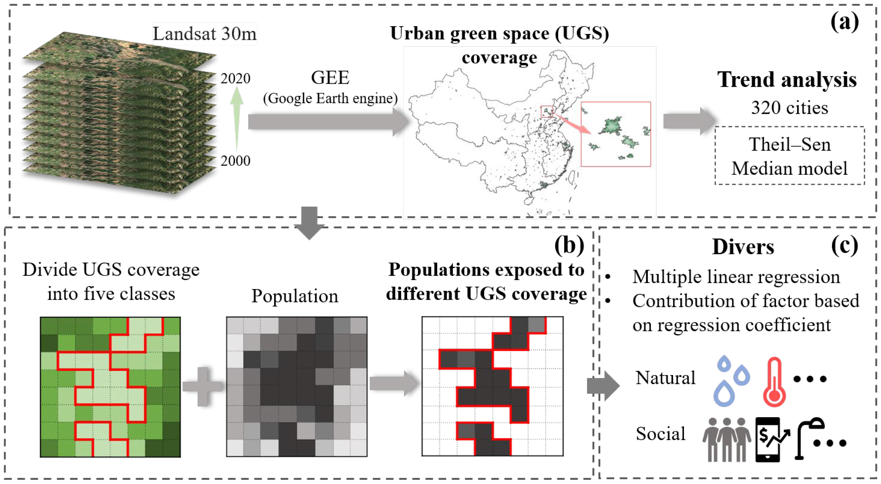
We quantified the UGS coverage in the built-up areas of 320 cities from 2000 to 2020 based on Landsat remote sensing image data and designed a research framework by considering the existing literature and research gaps (Figure 2). First, the changing trend of UGS coverage was determined to reflect the differences in UGS changes in different regions and cities of different sizes. Subsequently, we categorized the UGS coverage into five classes and analyzed the changes in the proportion of the areas in each class to gain insight into the transformation of green space conditions within cities. Based on this, we combined the UGS coverage data with the demographic data, calculated the proportion of the population exposed to different UGS coverages, and analyzed the law of its change. Finally, the influence of various factors on changes in UGSs was analyzed from both natural and social perspectives. This provides a reference point for cities undergoing rapid changes in UGSs.

2.3. Extraction of UGS Coverage

UGS coverage, defined as the vertically projected area of all ground vegetation as a percentage of the total statistical area, is an effective indicator of large-scale surface green space cover and growth. We used NDVI data to calculate UGS coverage using the pixel dichotomy model. The NDVI is a measure to estimate vegetation growth by comparing the reflectance of red and near-infrared bands, which is simple to calculate and sensitive to the change of UGS coverage [20,49]. It has been widely verified and applied in various environments and vegetation types and is one of the preferred vegetation indices in many remote sensing studies.
In this study, the Google Earth Engine (GEE) platform was employed to calculate UGS coverage using Landsat-5/7/8 images with a spatial resolution of 30 m from 2000 to 2020. The plant growing season (June to September) was selected as the period for calculating UGS coverage. The optimal pixel value was selected based on low cloud cover, low detection angles, and the maximum NDVI value of each pixel. This approach ensured that the obtained feature reflectance data are as close as possible to the actual situation.
N D V I = N I R R E D N I R + R E D
where NIR is the near-infrared band, RED is the red band.
U G S   c o v e r a g e = N D V I i N D V I s o i l N D V I v e g + N D V I s o i l
where NDVIi represents the NDVI value on the i pixel, NDVIsoil represents the NDVI value of bare soil or unvegetated areas, NDVIveg represents the NDVI value of the image element completely covered by vegetation, and UGS coverage takes the value range of [0–1]. In this study, NDVI image elements were counted, and NDVI values with cumulative probability distributions of 95% and 5% were selected to represent NDVIveg and NDVIsoil, respectively, to eliminate noise errors.
Applying the Jenks natural breaks classification method, we divided the UGS coverage into five classes (lowest: 0–20%, low: 20–40%, medium: 40–60%, high: 60–80%, and highest: 80–100%). Our study area was urban built-up areas, and we calculated the proportion of each UGS coverage class in the urban built-up areas. This study used a superimposition of demographic and UGS coverage data to calculate the proportion of residents with different UGS coverage, thereby representing the situation of residents exposed to different UGS coverage. Demographic data were obtained from www.worldpop.org, and gridded population count datasets were used. The number of people distributed in the areas of each UGS coverage class was divided by the total population of the city in the same year to obtain the proportion of the urban population within each UGS coverage class in the city.
R a r e a = A i j A j × 100
where j is the time series data, Aij is the area of UGS coverage of class i in year j, and ∑Aj is the total land area of the corresponding city in that year.
R p o p = P i j P j × 100
where Pij denotes the total population on image elements of UGS coverage of class i, and ∑Pj denotes the total population of the city in the same year.

2.4. Spatiotemporal Trend Analysis of UGS Coverage and Its Exposed Population

To gain a deeper understanding of the dynamics of UGS coverage and other variables over time in the 320 cities, we analyzed the trends of change using the Theil–Sen median model. The Theil–Sen median model is a robust nonparametric statistical approach to computing trends. This method has strong resistance to outliers, can capture the overall trend of the data, and provide a more reliable slope estimation [19].
β = m e d i u m x j x i j i , j > i
where j and i are time-series data, xj and xi represent the values of the variables in years j and i, respectively. β is the slope of the variable, if β > 0, it indicates that the variable has an increasing trend, otherwise it has a decreasing trend.

2.5. Multiple Linear Regression and Variance Decomposition

2.5.1. Natural and Social Driving Factors

We referred to previous studies and considered the scientific, representative, and quantifiable selection of driving factors, identified the driving factors, and analyzed the influence of each factor on UGS coverage.
Moisture and temperature are important environmental factors that influence plant growth. Adequate water and suitable temperatures are essential for healthy plant growth. We used two datasets to analyze the natural factors that influence UGSs in cities. (1) The TerraClimate dataset provides monthly climate and climate–water balance information for the global land surface [50]. In this study, actual evapotranspiration (AET), soil moisture (Soil), and climate water deficit (Def) were used. (2) WorldClim is a database of global weather and climate data with high spatial resolution (https://www.worldclim.org/ accessed on 17 March 2024). Precipitation (Prec), minimum surface temperature (Tmin), and maximum surface temperature (Tmax) were used in this study.
For social factors, we selected the percentage of impervious surface (ISA), population count (POP), gross domestic product (GDP), and nighttime light (NTL). The percentage of impervious surfaces was calculated using land-cover data from the National Land Use Classification (https://zenodo.org/records/5816591#.ZAWM3BVBy5c accessed on 15 December 2023). Population data were obtained from WorldPop (https://hub.worldpop.org/ accessed on 20 March 2024), and the Population Counts dataset was used to calculate the total population within a certain range. The GDP data reflect the economic strength and development trends of each city and were obtained from the National Bureau of Statistics website (https://nigerianstat.gov.ng/ accessed on 5 April 2024). Nighttime lighting data were obtained from the National Center for Environmental Information (https://www.ncei.noaa.gov/data/global-summary-of-the-day/archive/ accessed on 20 April 2024).

2.5.2. Driving Analysis

To fully understand the effects of urbanization and the natural environment on changes in UGS, we used multiple linear regression models. A multiple linear regression analysis was used to evaluate the relationship between dependent variables and several independent variables. In this study, the trends of change in natural factors (AET, Soil, Def, Prec, Tmin, and Tmax) and social factors (ISA, POP, GDP, and NTL) were used as independent variables, and the trend of change in UGS coverage was used as the dependent variable, taking into account geographical differences.
We normalized the variable data in the range 0–1 to make the data comparable. If the independent variables in the regression model are correlated with each other, collinearity may occur; therefore, we performed a collinearity diagnostic between the factors. The results showed that the variance inflation factor (VIF) of each factor was less than 10, and there was no collinearity among the factors. Multiple linear regression was used to examine the effect of each factor (10 items in total) on urban green space change, and the regression coefficients obtained represented the contributions of each variable.
Y = β 1 X 1 + β 2 X 2 + β 3 X 3 + β n X n + ε
where Xi is
β i β 1 + β 2 + + β n
where Y is the predicted value of the slope of the change in UGS coverage. ε denotes the difference between the predicted value Y and the true value Y; we assume that ε is a random variable with an expectation of 0. In other words, ε = 0. βi (i = 1, 2, …, n) is the regression coefficient of the multiple linear regression, and Xi is the slope of the change in the independent variable.
We use the regression coefficient β as the basis for the magnitude of the effect of the different independent variables on the dependent variable, whose values are directly comparable, owing to the elimination of the scale of the independent variables. Therefore, the contribution ratio of each factor was obtained by dividing the regression coefficients of each factor by the sum of the regression coefficients of all factors.

3. Results

3.1. Change in UGS Coverage

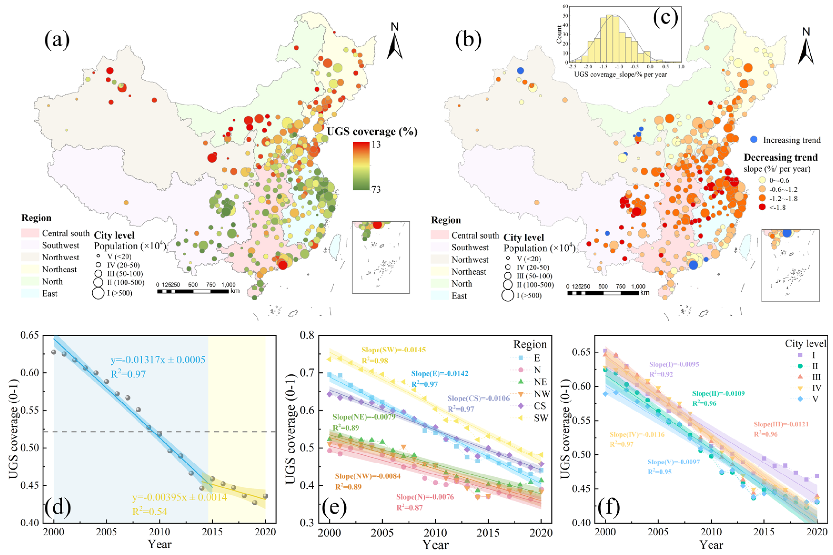
From 2000 to 2020, the UGS coverage of Chinese built-up areas decreased at a rate of 1.14% per year, from 63% to 44% (Figure 3d), which was equivalent to an annual loss of 1019.7 km2 of green space. The rate of decline was concentrated at 0–2%/year in 94.1% of the 320 major cities (Figure 3c), and only eight cities in the country showed a positive growth trend in UGS coverage (Figure 3b). The study cycle was divided into two parts based on the trend in UGS coverage change: the rapid decline phase (2000–2014) and the progressive decline phase (2015–2020). In the rapid decline phase, UGS coverage declined by 1.32% per year (Figure 3d). In contrast, during the progressive decline phase, UGS coverage increased in 2015, after which the rate of decline slowed to 0.395% per year (Figure 3d). Notably, UGS coverage in the southern part of China was higher than in the north, yet the rate of decline was greater in the south, particularly in the SW (Figure 3e).
Significant differences in UGS coverage changes were observed across the regions. The SW, E, and CS regions exhibited the greatest threats to UGS coverage, with decline rates of 1.45%, 1.42%, and 1.06% per year, respectively (Figure 3e). In the CS region, UGS coverage declined more slowly in the south than in the central region, and most southern cities experienced a decline of <1.2% per year (Figure 3b). The northern region exhibited the slowest decline in UGS coverage, with an average of 0.76% per year (Figure 3e). Interestingly, after 2015, the UGS coverage in the NE, N, and NW regions showed an upward trend, whereas that in the SW, CS, and E regions continued to decline (Figure 3e).
The cities were classified into five levels according to their population size. As city size decreased, the rate of change in UGS coverage exhibited an inverted U-shape pattern (Figure 3f). The rate of decline of UGS coverage in megacities (I) and smaller cities (V) was relatively low at 0.95% per year and 0.97% per year, respectively. The decline rate of UGS coverage in medium-sized cities (III) was relatively high, with an average annual decline rate of 1.21% per year. Furthermore, 55% of the medium-sized cities exhibited a rate of decline of >1.8%. The declining rates of UGS coverage in large (II) and small cities (IV) were 1.09% and 1.16% per year, respectively. In 2015 and beyond, megacities had significantly higher UGS coverage than the other cities (Figure 3f).
Overall, UGS coverage in cities across the country showed a downward trend, with rapid declines in both the SW and E. In terms of city size, the threat to UGS coverage was relatively high in medium-sized cities.

3.2. The Changing Patterns of Urban Areas with Different UGS Coverage and Urban Population Exposure to Different UGS Coverage

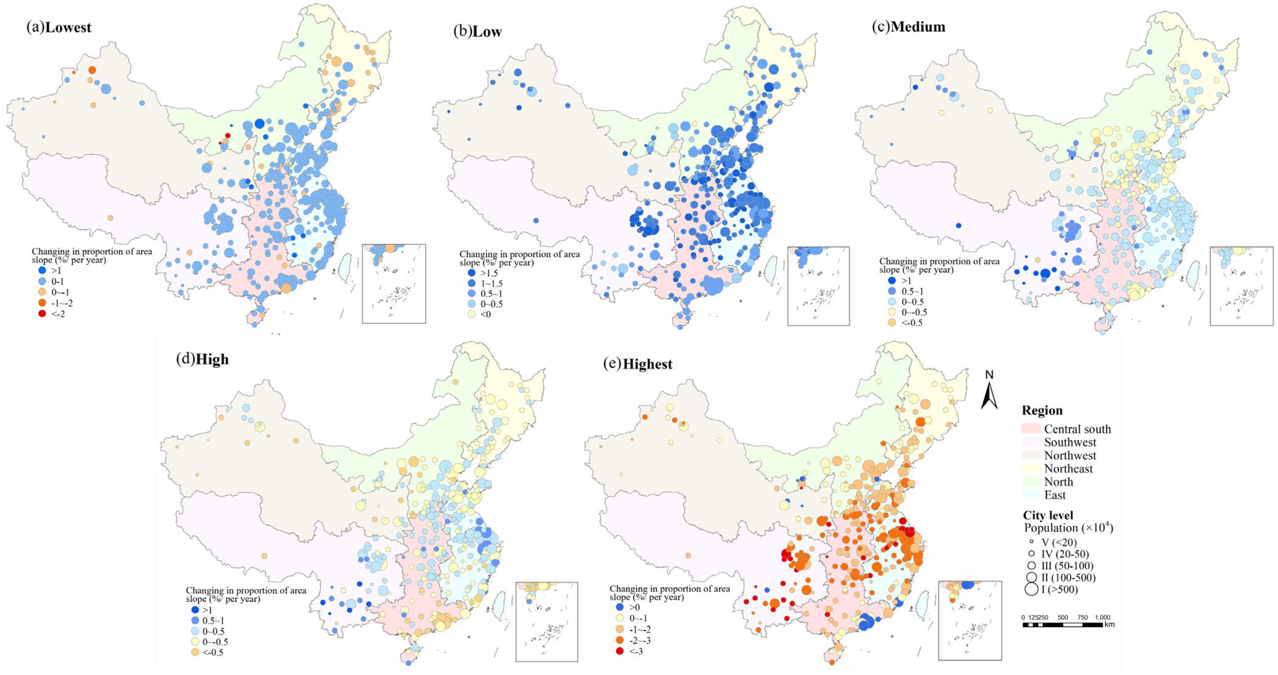
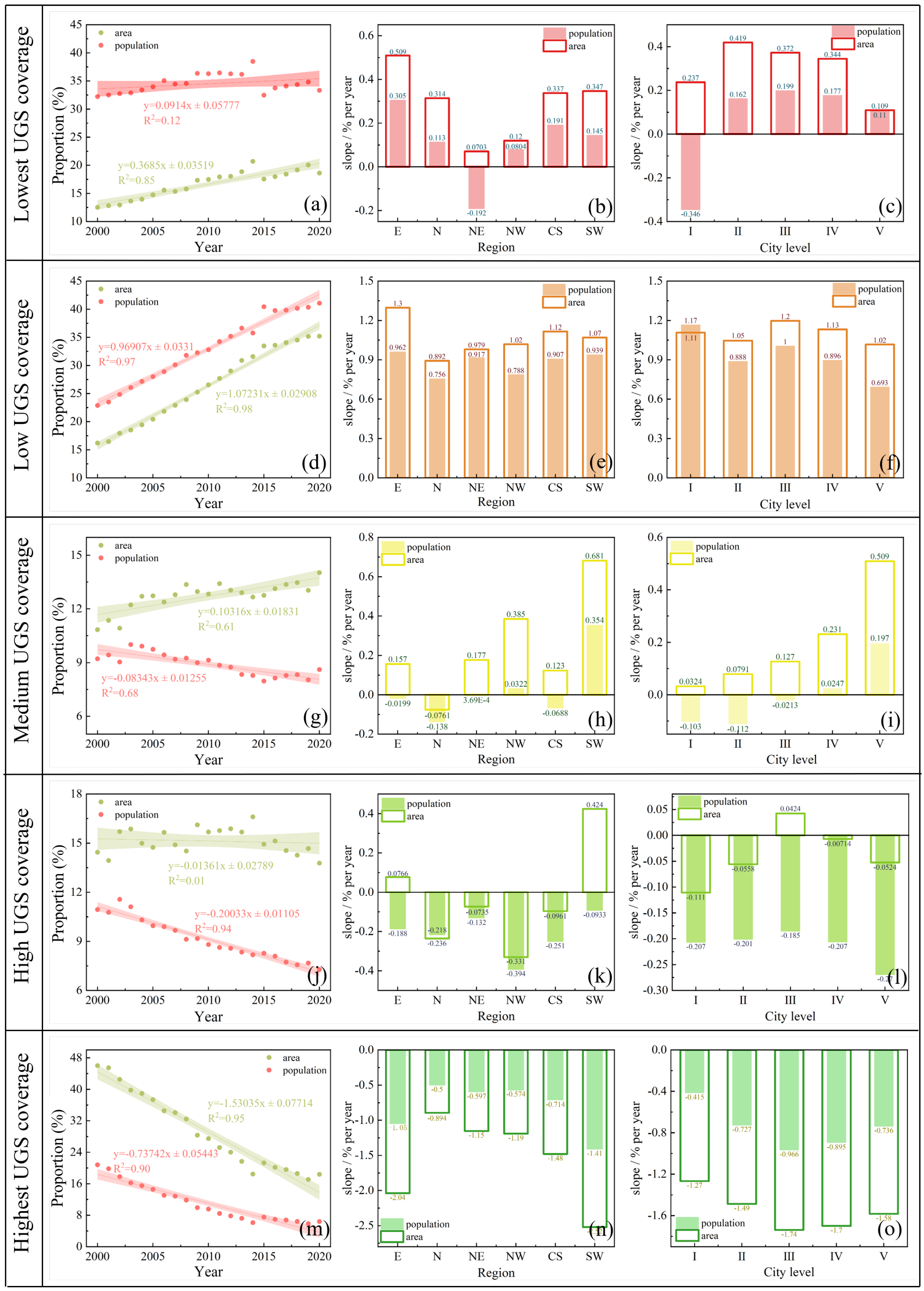
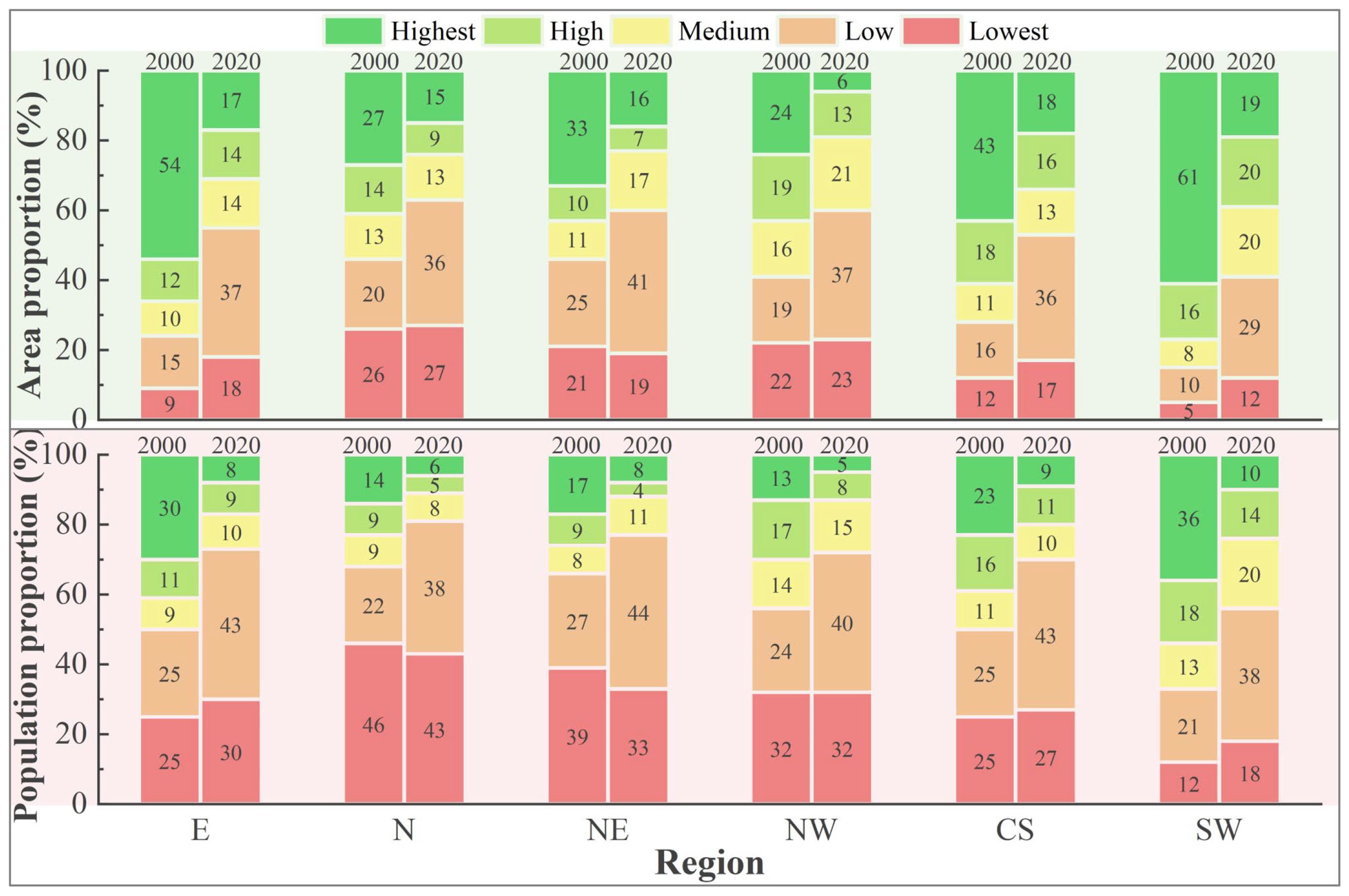
The UGS coverage of Chinese cities has changed from the highest to low class, resulting in the deterioration of the UGS environment. The proportion of urban areas with low UGS coverage exhibited the greatest increase(Figure 4b and Figure 5d), 75.6% of the cities exhibited a rate of change between 0.5% and 1.5% per year (Figure 4b). The area proportion of low UGS coverage increased from 16.2% in 2000 to 35.2% in 2020, representing a net increase of 19,260.9 km2 with an average increase of 963.05 km2 per year (Figure 5d). The proportion of urban areas with the highest UGS coverage experienced the greatest rate of decline, from 46% in 2000 to 18.4% in 2020 (Figure 5m), with an average annual decrease of 1410.3 km2. The proportions of the medium (0.103% per year) and high (−0.01% per year) UGS coverage classes underwent a more moderate change (Figure 5g,j).
The proportion of urban areas with the highest UGS coverage in the E (2.04% per year) and SW (2.52% per year) regions declined at a faster rate than that in the other regions (Figure 5n). The proportions of areas with the highest UGS coverage in the cities of the SW region were most at risk and declined from 61% to 19% (Figure 6). The rate of decrease in the proportion of areas with the highest UGS coverage was faster in the CS regions (1.48% per year) (Figure 5n); however, some cities in the Pearl River Delta region demonstrated an increasing trend in the proportion of areas with the highest UGS coverage (Figure 4e). The proportions of areas with the lowest (0.509% per year) and low (1.3% per year) UGS coverage in the E region increased at the fastest rate (Figure 5b,e). For medium UGS coverage, only the N region exhibited a declining trend in the proportion of the areas (0.076% per year), whereas the remaining regions exhibited an increasing trend (Figure 5h). The SW region exhibited the fastest rate of increase in the proportion of areas with medium UGS coverage (0.618% per year) (Figure 5h), with most cities demonstrating an increase of more than 0.5% per year (Figure 4c). Changes in the proportion of urban areas with high UGS coverage in the CS regions were regional; most cities in the central region showed an increasing trend, whereas most cities in the south showed a decreasing trend (Figure 4d).
For different city levels, the proportion of areas with low UGS coverage increased the fastest (I: 1.11% per year, II: 1.05% per year, III: 1.2% per year, IV: 1.13% per year, and V: 1.02% per year) (Figure 5f). The proportion of areas with the highest UGS coverage class declined the fastest, and the rate of decline exhibited a U shape, i.e., the proportion in medium cities declined the most (1.74% per year) (Figure 5o). The growth rate of the proportion of areas with medium UGS coverage areas was negatively correlated with city size (Figure 5i); the smaller the population and the smaller the city, the greater the rate of change in the proportion of areas with medium UGS coverage. For high UGS coverage, there was a decreasing trend in the proportion of areas for all classes of cities, with the exception of medium cities, which exhibited an increasing trend in the proportion of areas (0.042% per year) (Figure 5l).
Owing to urbanization and other reasons, the area with the highest UGS coverage is decreasing, and the urban residents exposed to the highest UGS coverage may move to the lowest and low UGS coverage areas due to industrial development and living conditions. This trend has led to a rapid reduction in the proportion of the population exposed to the highest UGS coverage (0.737% per year) (Figure 5m), with a decrease of 56 million people from 2000 to 2020. The proportion of the urban population exposed to low UGS coverage increased rapidly (0.969% per year) (Figure 5d), with an increase of 146 million people from 2000 to 2020. There was a large disparity between the proportion of areas in each class of UGS coverage and the proportion of the population exposed to each class of UGS coverage, and green spaces were unevenly distributed in the cities. The proportion of the population exposed to the lowest and low UGS coverage were greater than the proportion of areas in that class, especially for the lowest UGS coverage (Figure 5a,d). In 2000, 12.5% of the urban areas with the lowest UGS coverage comprised 32.2% of the urban population (Figure 5a). In 2020, 18.6% of the urban area with the lowest UGS coverage comprised 33.3% of the urban population (Figure 5a). The gap between the proportion of urban areas with medium and high UGS coverage and the proportion of the population exposed to the corresponding UGS coverage class gradually widened. (Figure 5g,j). The gap between the proportion of the population exposed to the highest UGS coverage class and the proportion of areas in that class gradually decreased. (Figure 5m). In 2000, 46.01% of the urban areas with the highest UGS coverage comprised 20.8% of the urban population (Figure 5m). In 2020, 18.4% of the urban area with the highest UGS coverage comprised 6.4% of the urban population (Figure 5m).
While the proportion of areas with the lowest UGS coverage in the northeast showed an upward trend, the proportion of the population exposed to this class showed a downward trend, with the population proportion declining by an average of 0.192% per year (Figure 5b). The increase in the proportion of the population exposed to low UGS coverage in the E region exceeded that in other regions, with an average increase of 0.962% per year, followed by the SW region (0.939% per year) (Figure 5e). In SW China, the proportion of the population exposed to medium UGS coverage increased significantly (0.354% per year) (Figure 5h). Although the proportion of areas with high UGS coverage expanded in the E and SW regions, the proportion of people exposed to this class showed a declining trend in both regions (Figure 5k). The SW (1.41% per year) and E (1.05% per year) regions showed a significant decline in the proportion of the population exposed to the highest UGS coverage (Figure 5n). This proportion decreased from approximately 30% to 10% during the study period (Figure 6). In 2020, the total proportion of the population exposed to the lowest and low UGS coverage in the north region reached 81% (Figure 6).
Regarding urban areas, megacities (I) exhibited a notable decline in the proportion of the population exposed to the lowest UGS coverage (Figure 5c). This decline occurred at an average rate of 0.346% per year, a trend that differed from that observed in other cities (Figure 5c). The change in the proportion of the population exposed to the highest UGS coverage at each city level was similarly distributed in a v-shaped pattern, with the fastest rate of decline in medium-sized cities (III) (0.966% per year) and the slowest rate of decline in megacities (0.415% per year) (Figure 5o). The proportion of the population exposed to low UGS coverage rose most dramatically in megacities (1.17% per year) (Figure 5f), reaching 44% by 2020 (Figure 7). In 2020, the sum of the urban areas with medium, high, and the highest UGS coverage in smaller cities (51%) and the sum of the population proportion (41%) exposed to these three classes was higher than in other cities (Figure 7).

3.3. Driving Mechanism of the UGS Coverage

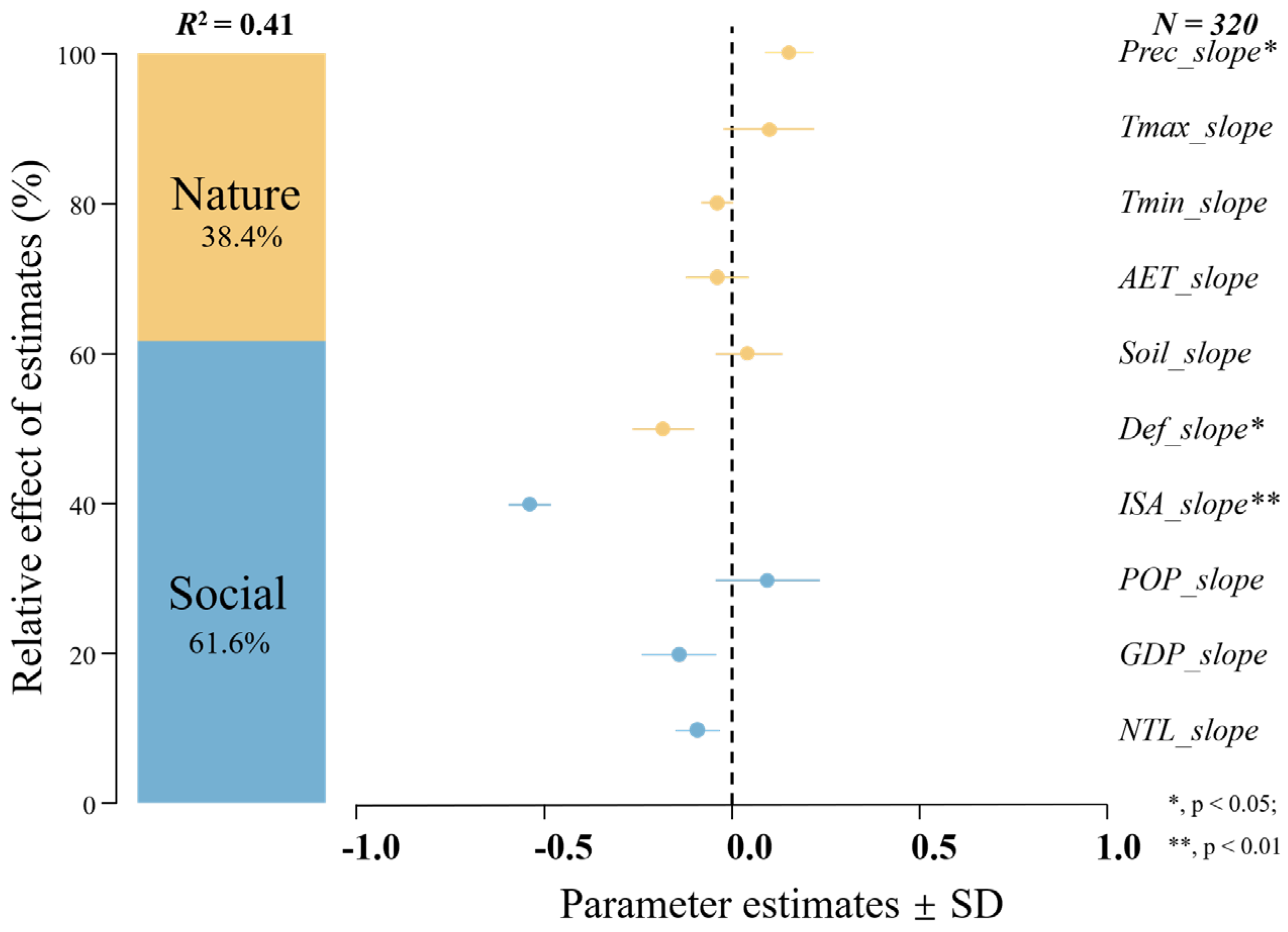
All the regressions in this study passed the covariance test (VIF < 10). The effect of the trends of different factors on the trend of UGS coverage change in stages (2000–2020, 2000–2014, and 2015–2020) were analyzed based on the trend of the annual average UGS coverage. In all three time periods analyzed, social factors dominated the overall change in UGS coverage in the city, mainly the ISA (Figure 8, Figure 9 and Figure 10). Over the entire study period (2000–2020, R2 = 0.57), the ISA explained 41.7% of the variation in UGS coverage, NTL explained 10.8% of the variation in UGS coverage, and Tmax and Soil together explained 23.4% of the variation in UGS coverage (Figure 8). During the rapid decline phase (2000–2014, R2 = 0.64) (Figure 9), the urban ISA explained 38.4% of the change in UGS coverage. Furthermore, Prec, Soil, and Def had significant effects on UGS coverage, explaining 29.8% of the change in UGS coverage. During the progressive decline phase (2015–2020, R2 = 0.41) (Figure 10), the ISA continued to exert a significant influence on the change in UGS coverage (37.7%), with Prec and Def explaining 10.2% and 12.6%, respectively.

4. Discussion

4.1. Significant Decline in UGS Coverage in Built-Up Areas

We found that from 2000 to 2020, UGS coverage in China continued to decrease (Figure 3d). This was mainly characterized by the transformation from the highest UGS coverage to a low UGS coverage (Figure 5d,m). However, some studies and statistical data showed an increasing trend of UGS coverage in the urban areas of China [21,51,52]. The reasons for this contradiction may be as follows. (1) Different studies have used different methodologies to delineate the boundaries of their respective study areas. Some studies have utilized administrative divisions as the boundaries of their study areas [21], whereas we have drawn the boundaries of the 2020 urban built-up area based on impervious surfaces, which more closely align with the primary areas of urban residents’ activities. (2) Some studies on spatial and temporal changes in UGSs have only considered large cities [51]; however, the pattern of change in UGS coverage may vary in different urbanized areas. (3) Different definitions of UGSs exist. In our study, UGSs were defined as all types of green space in the city. However, in some studies, UGSs are narrowly defined as public green spaces with a large amount of vegetation [52], such as parks and botanical gardens, which have the function of planned and fixed green spaces in the city; this may lead to the neglect of the sparse distribution of vegetation in smaller plots, and thus, underestimation of UGS coverage in urban areas. Furthermore, the calculation of UGS coverage is influenced by the quality and resolution of the remotely sensed imagery [22]. The continuous reduction in UGS coverage poses a threat to the ecological balance of the city and negatively impacts sustainable development.
The Chinese government has made coordinated efforts to promote the construction of an ecological civilization. In 2015, the document Opinions on Accelerating the Promotion of the Construction of an Ecological Civilization was issued [53], representing a significant policy document aimed at strengthening the construction of an ecological civilization and promoting resource conservation and environmental protection. Furthermore, the National Plan for New-Type Urbanization (2014–2020) prioritizes the acceleration of the development of small- and medium-sized cities, with the construction of an ecological civilization forming an integral part of the urbanization process [54]. Furthermore, there is a possibility that the deceleration in the decline of UGS coverage after 2015 is due to a reduction in available room for decline. Our study indicated that 2015 marked a turning point in the rapid decline of UGS coverage (Figure 3d), and this result is closely related to national policy. Nevertheless, the accelerated urbanization process has led to the development of land on the outskirts of cities, resulting in a significant reduction in UGSs that cannot be fully offset by an increase in green spaces in the urban core [55]. Consequently, the overall trend of UGS coverage remained on a downward trajectory and showed significant spatial variability. The decline in UGS coverage will exacerbate the urban heat island effect, and low UGS coverage may make cities more vulnerable to natural disasters [56]. Therefore, adopting a more integrated and sustained strategy for urban planning and development is imperative.
The rate of decline in UGS coverage was higher in the southern regions than in the northern regions of China, which is consistent with the results of previous studies (Figure 3e) [55]. The Yangtze River Delta and the Sichuan–Chongqing regions exhibited the most rapid decline in UGS coverage (Figure 2b). The declining trend in UGS coverage in southern China may be related to rapid urbanization and industrialization. Additionally, the relatively high temperatures and intensity of human activities in the Sichuan–Chongqing region may also intensify the decline in local UGS coverage [57]. In contrast, the Pearl River Delta region has emphasized the construction and protection of the ecological environment while expanding its cities, and has implemented a series of forest protection and reforestation projects [58]. After 2015, UGS coverage began to increase in northern China (N, NE, and NW) (Figure 3e), a trend attributed to a combination of factors. Urban temperatures in China have increased significantly in recent decades, leading to longer vegetation growth periods [33]. Second, the implementation of large-scale ecological protection and restoration projects by the Chinese government (e.g., Northern Sand Belt) has also contributed to this increase [59,60]. Furthermore, the spontaneous enhancement of green spaces by residents (including the planting of trees and irrigation of urban greenery) has had a beneficial effect on UGS coverage in the northern region.
The varying stages and intensities of urbanization also influenced the extent of change in UGS coverage. At a certain stage of urbanization, megacities have begun to recognize the significance of UGSs for human physical and mental health, leading to the adoption of more environmental protection measures and the allocation of greater resources and policies to optimize the allocation and quality of UGSs [61]. Feng et al. [20] found that the green space growth rate in the core areas of megacities was faster than that of other cities. Furthermore, it has been demonstrated that the higher the administrative structure of the city, the more effective the city’s policy implementation [62]. These studies corroborate the results of the present study and provide a theoretical basis for it. Additionally, the increase in the residents’ demand for UGSs has prompted real estate construction to move in a greener direction [63]. In contrast, medium-sized cities experienced large-scale land development activities during this time, which may have led to a faster decline in UGS coverage, owing to a lack of awareness of ecological protection, effective environmental policies, and management measures (Figure 3f). Consequently, achieving a reasonable balance between urban expansion and ecological protection has become an important issue in the planning and management of medium-sized cities.

4.2. Changes in the Proportion of Urban Areas within Different UGS Coverage Classes and the Urban Population Exposed to Different UGS Coverage Classes

High UGS coverage is often associated with positive impacts [7,20,49]. Additionally, studies have demonstrated that a reduction in UGSs can negatively impact residents’ mental health [64,65]. As urban built-up areas continue to expand, existing green spaces are replaced by buildings or impervious surfaces, resulting in a rapid decline in the proportion of areas with the highest UGS coverage and a rapid increase in the proportion of areas with low UGS coverage within urban built-up areas across the country. Geographically, the E and SW regions exhibited the fastest decline in the proportion of areas with the highest UGS coverage. Regarding city class, the highest UGS coverage declined at the fastest rate in medium-sized developing cities. To address these challenges, it may be necessary to implement more sustainable land management practices to protect and restore UGSs. Such practices could include strengthening local plant protection regulations, restricting unsustainable agricultural and industrial activities, rehabilitating degraded ecosystems, and raising local residents’ environmental awareness.
By combining UGS coverage data with demographic data, it was possible to quantify temporal trends in the proportion of the population exposed to different UGS coverage levels from 2000 to 2020. The results of this analysis indicated that the distribution of green space resources in cities is uneven. Approximately 40% of the urban population was exposed to low UGS coverage in 2020, whereas residents with the highest UGS coverage comprised only a small fraction of the urban population (Figure 5). Low UGS coverage may exacerbate air and noise pollution in urban environments, adversely affecting the health of residents [66]. The lack of UGSs can also lead to a shortage of outdoor recreational areas for city dwellers, potentially causing mental health issues [67]. Regarding the population distribution, areas with low UGS coverage tended to correspond to areas with a high population density. This is due to the fact that areas with a low UGS coverage tend to overlap with industrial areas [68], which may be less desirable due to industrial pollution, noise, and a lower quality of life. However, owing to the concentration of industry, these areas often provide a large number of employment opportunities, leading to a concentration of the population [69]. This concentration of the population can lead to economic vitality, but it may also bring challenges regarding urban planning and management, such as traffic congestion, environmental pollution, and pressure on social services. In modern society, UGSs are regarded as valuable economic resources [70]. As people’s income levels increase, their pursuit of high-quality living environments also increases. Areas with more green spaces typically offer pleasant climatic conditions, more space for recreation, and better air quality [71]. The combination of these factors makes these areas the preferred choice for people seeking high-quality living. The uneven spatial distribution of UGSs also reflects a complex socioeconomic issue that reveals inequalities in urban planning and resource allocation. Higher-income groups tend to enjoy more benefits from green spaces, whereas residents of lower economic status enjoy fewer green space services, exacerbating the inequalities between groups [72]. This is particularly evident in urban planning and development.
The equitable distribution of UGSs is a significant public policy issue closely linked to socioeconomic equity, the health of residents, and sustainable development of cities [72,73]. Consequently, when formulating development strategies, urban planners face the challenge of balancing urban environments with industrial development. To achieve an equitable distribution of green spaces, it is necessary to consider the distribution of employment opportunities in a more comprehensive manner. Furthermore, it is essential to identify the optimal balance between the provision of adequate employment opportunities and the quality of life to ensure that all residents in our society enjoy a high-quality living environment.

4.3. Drivers of UGS Coverage by Different Factors

Our findings indicate that urbanization is a significant factor influencing changes in UGS coverage (Figure 8) [19,74], which is consistent with previous research. With urban expansion, the original natural surfaces are replaced with hard impervious surfaces, which reduces the space for vegetation growth. In natural environments, temperature and rainfall have positive effects on vegetation growth; however, in urban areas, this result may be reversed [75]. The results indicated that rainfall exhibited a significant negative correlation with UGS coverage during the rapid decline phase (2000–2015). However, this negative correlation does not imply that precipitation directly caused the decline in UGS coverage; urbanization may also have played a role, with impervious surfaces as well as soil compaction reducing the infiltration and evaporation of surface moisture [76]. While annual rainfall exhibited a slight upward trend across the country during the 2000–2015 period, the precipitation trend varied between the regions. Furthermore, the frequency of extreme rainfall events has increased nationwide [77,78]. The SW region has experienced a significant downward trend in rainfall and a high frequency of spring drought events, which have impacted the change in UGS coverage in this region [79,80]. This study demonstrated that changes in UGS coverage exhibited a negative correlation with changes in maximum surface temperature (with the exception of the progressive decline phase, p < 0.05). Furthermore, climate water deficits contribute to a reduction in UGS coverage [81], which is linked to urban surface temperatures. Higher surface temperatures result in less moisture in the atmosphere, which places greater pressure on vegetation transpiration and causes faster water loss [82]. It has been suggested that urban thermal environments are significantly deteriorating, with the number of Chinese residents at risk of thermal exposure increasing by approximately four million per year [47,56]. However, the increase in urban surface temperature may be due to the indirect effects of urbanization [83]. During the progressive decline phase, brief temporal intervals between observations constrain our understanding of how natural factors contribute to alterations in UGS coverage. Urbanization has reduced the space available for vegetation growth, leading to a decrease in the cooling effect of green spaces on the city as a whole. Factors may play different roles at different stages; however, the effect of increased impervious surfaces on UGS coverage cannot be ignored.

4.4. Limitations and Future Research Directions

Due to the 30 m spatial resolution of Landsat images, small green space patches may not be well captured, leading to limited accuracy in calculating UGS coverage. With the advancement of remote sensing technology, higher resolution remote sensing data can be used for vegetation index calculations. Owing to computational constraints, we used only the boundaries of built-up areas for one year as the study scope for the entire research. In future research, it may be beneficial to consider using urban built-up area boundaries for each year as the study scope, rather than just relying on the boundaries of built-up areas for one year, in order to better align with the evolving activity ranges of urban residents. Multifactor analyses of the drivers of UGS coverage may be insufficient to assess the impact of various factors on UGS coverage within shorter time intervals. The influence of many natural factors may not be significant, and the effects of different factors on UGS coverage may change over time.

5. Conclusions

A quantitative analysis of Landsat image data was conducted to assess the changes in UGS coverage within built-up areas and the changing patterns of urban population exposure to different UGS coverage for 320 Chinese cities from 2000 to 2020. The main conclusions are as follows:
  • We found that UGS coverage in built-up areas of cities across China was in a continuous state of decline. This decline was more rapid from 2000 to 2014, with an average decrease of 1.32% per year. Thereafter, the rate of decrease in UGS coverage slowed. Geographically, the eastern and southwestern regions exhibited the most rapid decline in UGS coverage, with urban vegetation facing the greatest threat. At the urban level, medium-sized cities exhibited a faster rate of decline in UGS coverage. After 2015, the UGS coverage in megacities was significantly higher than that in other cities. We should implement strict regulations to protect UGSs, especially in areas experiencing rapid declines in UGS coverage, and increase residents’ awareness of the importance of preserving UGSs.
  • We found that the urban pixel-based areas in cities with the highest UGS coverage decreased rapidly, and the proportion of the urban population exposed to the highest UGS coverage was 20.8% in 2000 and decreased to 6.4% in 2020, a decrease of 56 million people. Urban pixel-based areas with low UGS coverage continued to expand, and there was a rapid increase in the proportion of the urban population exposed to low UGS coverage. In the southwestern and eastern regions, the proportion of areas with the highest UGS coverage and the proportion of the population exposed to the highest UGS coverage were rapidly decreasing. In terms of urban size, the proportion of areas with the highest UGS coverage and the proportion of the population exposed to the highest UGS coverage decreased significantly in medium-sized cities. We also found that the proportion of the population exposed to the lowest UGS coverage declined in megacities.
  • The percentage of impervious surfaces in a city had the most significant effect on UGS coverage. In addition, precipitation, maximum surface temperature, and climate water deficit were negatively correlated with UGS coverage. However, these correlations may be indirectly influenced by urbanization. Rapid urbanization and its indirect effects on urban environments have accelerated the reduction in UGS coverage in built-up areas. The government should formulate urban planning policies to restrict the increase of impervious surfaces and encourage or mandate the establishment of more green spaces in the urban development process.
It is imperative to recognize the significant variations in UGS coverage among different regions and cities of varying sizes. To achieve a sustainable urban environment, it is essential to find a balance between urban development and ecological maintenance, emphasize the fairness of green space distribution, and realize the sustainable development of urban environments.

Author Contributions

Methodology, Z.R. and C.Z.; software, R.G. and C.W.; validation, R.G. and P.Z.; investigation, Y.G., S.H. and W.H.; data curation, F.M. and N.F.; writing—original draft, C.Z., R.G. and Z.R.; writing—review and editing, C.Z. and R.G. All authors have read and agreed to the published version of the manuscript.

Funding

This research was funded by the Natural Science Foundation of Jilin Province (grant number 2022LY427L23); the Youth Innovation Promotion Association of Chinese Academy of Sciences [grant number 2020237]; Research Start-up Funds for Doctoral Talents of Changchun University (grant number 2023JBE27L39); and the National Natural Science Foundation of China [grant number 42171109, 32130068].

Data Availability Statement

The original contributions presented in the study are included in the article, further inquiries can be directed to the corresponding author.

Conflicts of Interest

The authors declare no conflicts of interest.

References

  1. Liang, W.; Yang, M. Urbanization, economic growth and environmental pollution: Evidence from China. Sustain. Comput. Inform. Syst. 2019, 21, 1–9. [Google Scholar] [CrossRef]
  2. Ritchie, H.; Roser, M. Urbanization. Available online: https://ourworldindata.org/urbanization (accessed on 10 May 2024).
  3. Olimid, A.P.; Olimid, D.A. Societal challenges, population trends and human security: Evidence from the public governance within the United Nations publications (2015–2019). Rev. Stiinte Politice 2019, 64, 53–64. [Google Scholar]
  4. Zhou, X.; Wang, Y.-C. Spatial–temporal dynamics of urban green space in response to rapid urbanization and greening policies. Landsc. Urban Plan. 2011, 100, 268–277. [Google Scholar] [CrossRef]
  5. Ma, X.; Huete, A.; Moran, S.; Ponce-Campos, G.; Eamus, D. Abrupt shifts in phenology and vegetation productivity under climate extremes. J. Geophys. Res. Biogeosci. 2015, 120, 2036–2052. [Google Scholar] [CrossRef]
  6. Allen, C.D.; Macalady, A.K.; Chenchouni, H.; Bachelet, D.; McDowell, N.; Vennetier, M.; Kitzberger, T.; Rigling, A.; Breshears, D.D.; Hogg, E.T. A global overview of drought and heat-induced tree mortality reveals emerging climate change risks for forests. For. Ecol. Manag. 2010, 259, 660–684. [Google Scholar] [CrossRef]
  7. Aronson, M.F.; Lepczyk, C.A.; Evans, K.L.; Goddard, M.A.; Lerman, S.B.; MacIvor, J.S.; Nilon, C.H.; Vargo, T. Biodiversity in the city: Key challenges for urban green space management. Front. Ecol. Environ. 2017, 15, 189–196. [Google Scholar] [CrossRef]
  8. Giannico, V.; Spano, G.; Elia, M.; D’Este, M.; Sanesi, G.; Lafortezza, R. Green spaces, quality of life, and citizen perception in European cities. Environ. Res. 2021, 196, 110922. [Google Scholar] [CrossRef] [PubMed]
  9. Hong, W.; Ren, Z.; Guo, Y.; Wang, C.; Cao, F.; Zhang, P.; Hong, S.; Ma, Z. Spatiotemporal changes in urban forest carbon sequestration capacity and its potential drivers in an urban agglomeration: Implications for urban CO2 emission mitigation under China’s rapid urbanization. Ecol. Indic. 2024, 159, 111601. [Google Scholar] [CrossRef]
  10. Guo, Y.; Ren, Z.; Wang, C.; Zhang, P.; Ma, Z.; Hong, S.; Hong, W.; He, X. Spatiotemporal patterns of urban forest carbon sequestration capacity: Implications for urban CO2 emission mitigation during China’s rapid urbanization. Sci. Total Environ. 2024, 912, 168781. [Google Scholar] [CrossRef] [PubMed]
  11. Gong, P.; Wang, J.; Yu, L.; Zhao, Y.; Zhao, Y.; Liang, L.; Niu, Z.; Huang, X.; Fu, H.; Liu, S. Finer resolution observation and monitoring of global land cover: First mapping results with Landsat TM and ETM+ data. Int. J. Remote Sens. 2013, 34, 2607–2654. [Google Scholar] [CrossRef]
  12. Huerta, R.E.; Yépez, F.D.; Lozano-García, D.F.; Guerra Cobian, V.H.; Ferrino Fierro, A.L.; de León Gómez, H.; Cavazos Gonzalez, R.A.; Vargas-Martínez, A. Mapping urban green spaces at the metropolitan level using very high resolution satellite imagery and deep learning techniques for semantic segmentation. Remote Sens. 2021, 13, 2031. [Google Scholar] [CrossRef]
  13. Zhang, M.; Tan, S.; Zhang, C.; Han, S.; Zou, S.; Chen, E. Assessing the impact of fractional vegetation cover on urban thermal environment: A case study of Hangzhou, China. Sustain. Cities Soc. 2023, 96, 104663. [Google Scholar] [CrossRef]
  14. Zhao, X.; Tan, S.; Li, Y.; Wu, H.; Wu, R. Quantitative analysis of fractional vegetation cover in southern Sichuan urban agglomeration using optimal parameter geographic detector model, China. Ecol. Indic. 2024, 158, 111529. [Google Scholar] [CrossRef]
  15. Ning, J.; Liu, J.; Kuang, W.; Xu, X.; Zhang, S.; Yan, C.; Li, R.; Wu, S.; Hu, Y.; Du, G. Spatiotemporal patterns and characteristics of land-use change in China during 2010–2015. J. Geogr. Sci. 2018, 28, 547–562. [Google Scholar] [CrossRef]
  16. Hurley, J.; Saunders, M.A.; Both, A.; Sun, C.; Boruff, B.; Duncan, J.; Amati, M.; Caccetta, P. Urban Vegetation Cover Change in Melbourne; Centre for Urban Research, RMIT University: Melbourne, Australia, 2019. [Google Scholar]
  17. Yang, Z.; Fang, C.; Li, G.; Mu, X. Integrating multiple semantics data to assess the dynamic change of urban green space in Beijing, China. Int. J. Appl. Earth Obs. Geoinf. 2021, 103, 102479. [Google Scholar] [CrossRef]
  18. Sikorska, D.; Łaszkiewicz, E.; Krauze, K.; Sikorski, P. The role of informal green spaces in reducing inequalities in urban green space availability to children and seniors. Environ. Sci. Policy 2020, 108, 144–154. [Google Scholar] [CrossRef]
  19. Zhang, P.; Dong, Y.; Ren, Z.; Wang, G.; Guo, Y.; Wang, C.; Ma, Z. Rapid urbanization and meteorological changes are reshaping the urban vegetation pattern in urban core area: A national 315-city study in China. Sci. Total Environ. 2023, 904, 167269. [Google Scholar] [CrossRef] [PubMed]
  20. Feng, F.; Yang, X.; Jia, B.; Li, X.; Li, X.; Xu, C.; Wang, K. Variability of urban fractional vegetation cover and its driving factors in 328 cities in China. Sci. China Earth Sci. 2024, 67, 466–482. [Google Scholar] [CrossRef]
  21. Wei, X.; Wang, S.; Wang, Y. Spatial and temporal change of fractional vegetation cover in North-western China from 2000 to 2010. Geol. J. 2018, 53, 427–434. [Google Scholar] [CrossRef]
  22. Liu, H.; Li, X.; Mao, F.; Zhang, M.; Zhu, D.E.; He, S.; Huang, Z.; Du, H. Spatiotemporal evolution of fractional vegetation cover and its response to climate change based on MODIS data in the subtropical region of China. Remote Sens. 2021, 13, 913. [Google Scholar] [CrossRef]
  23. Twohig-Bennett, C.; Jones, A. The health benefits of the great outdoors: A systematic review and meta-analysis of greenspace exposure and health outcomes. Environ. Res. 2018, 166, 628–637. [Google Scholar] [CrossRef] [PubMed]
  24. Hickman, C. ‘To brighten the aspect of our streets and increase the health and enjoyment of our city’: The National Health Society and urban green space in late-nineteenth century London. Landsc. Urban Plan. 2013, 118, 112–119. [Google Scholar] [CrossRef]
  25. Kondo, M.C.; Fluehr, J.M.; McKeon, T.; Branas, C.C. Urban green space and its impact on human health. Int. J. Environ. Res. Public Health 2018, 15, 445. [Google Scholar] [CrossRef]
  26. Nesbitt, L.; Meitner, M.J.; Sheppard, S.R.; Girling, C. The dimensions of urban green equity: A framework for analysis. Urban For. Urban Green. 2018, 34, 240–248. [Google Scholar] [CrossRef]
  27. Hunter, R.F.; Cleland, C.; Cleary, A.; Droomers, M.; Wheeler, B.W.; Sinnett, D.; Nieuwenhuijsen, M.J.; Braubach, M. Environmental, health, wellbeing, social and equity effects of urban green space interventions: A meta-narrative evidence synthesis. Environ. Int. 2019, 130, 104923. [Google Scholar] [CrossRef] [PubMed]
  28. Haaland, C.; van Den Bosch, C.K. Challenges and strategies for urban green-space planning in cities undergoing densification: A review. Urban For. Urban Green. 2015, 14, 760–771. [Google Scholar] [CrossRef]
  29. Hu, J.; Zhang, F.; Qiu, B.; Zhang, X.; Yu, Z.; Mao, Y.; Wang, C.; Zhang, J. Green-gray imbalance: Rapid urbanization reduces the probability of green space exposure in early 21st century China. Sci. Total Environ. 2024, 933, 173168. [Google Scholar] [CrossRef] [PubMed]
  30. Chen, B.; Wu, S.; Song, Y.; Webster, C.; Xu, B.; Gong, P. Contrasting inequality in human exposure to greenspace between cities of Global North and Global South. Nat. Commun. 2022, 13, 4636. [Google Scholar] [CrossRef] [PubMed]
  31. De la Barrera, F.; Henríquez, C. Vegetation cover change in growing urban agglomerations in Chile. Ecol. Indic. 2017, 81, 265–273. [Google Scholar] [CrossRef]
  32. Mu, B.; Zhao, X.; Zhao, J.; Liu, N.; Si, L.; Wang, Q.; Sun, N.; Sun, M.; Guo, Y.; Zhao, S. Quantitatively Assessing the Impact of Driving Factors on Vegetation Cover Change in China’s 32 Major Cities. Remote Sens. 2022, 14, 839. [Google Scholar] [CrossRef]
  33. Zhao, S.; Liu, S.; Zhou, D. Prevalent vegetation growth enhancement in urban environment. Proc. Natl. Acad. Sci. USA 2016, 113, 6313–6318. [Google Scholar] [CrossRef] [PubMed]
  34. Sandel, B.; Svenning, J.-C. Human impacts drive a global topographic signature in tree cover. Nat. Commun. 2013, 4, 2474. [Google Scholar] [CrossRef] [PubMed]
  35. Liu, X.; Pei, F.; Wen, Y.; Li, X.; Wang, S.; Wu, C.; Cai, Y.; Wu, J.; Chen, J.; Feng, K. Global urban expansion offsets climate-driven increases in terrestrial net primary productivity. Nat. Commun. 2019, 10, 5558. [Google Scholar] [CrossRef] [PubMed]
  36. Wang, S.; Ju, W.; Peñuelas, J.; Cescatti, A.; Zhou, Y.; Fu, Y.; Huete, A.; Liu, M.; Zhang, Y. Urban—Rural gradients reveal joint control of elevated CO2 and temperature on extended photosynthetic seasons. Nat. Ecol. Evol. 2019, 3, 1076–1085. [Google Scholar] [CrossRef] [PubMed]
  37. Sukopp, H.; Wurzel, A. Changing climate and the effects on vegetation in central European cities. Arboric. J. 2000, 24, 257–281. [Google Scholar] [CrossRef]
  38. Li, F.; Wang, X.; Liu, H.; Li, X.; Zhang, X.; Sun, Y.; Wang, Y. Does economic development improve urban greening? Evidence from 289 cities in China using spatial regression models. Environ. Monit. Assess. 2018, 190, 541. [Google Scholar] [CrossRef] [PubMed]
  39. Tong, S.; Zhang, J.; Ha, S.; Lai, Q.; Ma, Q. Dynamics of fractional vegetation coverage and its relationship with climate and human activities in Inner Mongolia, China. Remote Sens. 2016, 8, 776. [Google Scholar] [CrossRef]
  40. Mao, P.; Zhang, J.; Li, M.; Liu, Y.; Wang, X.; Yan, R.; Shen, B.; Zhang, X.; Shen, J.; Zhu, X. Spatial and temporal variations in fractional vegetation cover and its driving factors in the Hulun Lake region. Ecol. Indic. 2022, 135, 108490. [Google Scholar] [CrossRef]
  41. Yang, S.; Liu, C.; Sun, R. The vegetation cover over last 20 years in Yellow River Basin. Acta Geogr. Sin. Chin. Ed. 2002, 57, 679–684. [Google Scholar]
  42. Guo, Q.; Zhong, R.; Shan, Z.; Duan, X. Vegetation Cover Variation in Dry Valleys of Southwest China: The Role of Precipitation. Remote Sens. 2023, 15, 1727. [Google Scholar] [CrossRef]
  43. Li, Y.; Wang, X.; Chen, Y.; Wang, M. Land surface temperature variations and their relationship to fractional vegetation coverage in subtropical regions: A case study in Fujian Province, China. Int. J. Remote Sens. 2020, 41, 2081–2097. [Google Scholar] [CrossRef]
  44. Mu, B.; Zhao, X.; Wu, D.; Wang, X.; Zhao, J.; Wang, H.; Zhou, Q.; Du, X.; Liu, N. Vegetation cover change and its attribution in China from 2001 to 2018. Remote Sens. 2021, 13, 496. [Google Scholar] [CrossRef]
  45. Zhou, W.; Wang, J.; Qian, Y.; Pickett, S.T.; Li, W.; Han, L. The rapid but “invisible” changes in urban greenspace: A comparative study of nine Chinese cities. Sci. Total Environ. 2018, 627, 1572–1584. [Google Scholar] [CrossRef] [PubMed]
  46. Dong, Y.; Ren, Z.; Fu, Y.; Miao, Z.; Yang, R.; Sun, Y.; He, X. Recording urban land dynamic and its effects during 2000–2019 at 15-m resolution by cloud computing with Landsat series. Remote Sens. 2020, 12, 2451. [Google Scholar] [CrossRef]
  47. Dong, Y.; Ren, Z.; Fu, Y.; Hu, N.; Guo, Y.; Jia, G.; He, X. Decrease in the residents’ accessibility of summer cooling services due to green space loss in Chinese cities. Environ. Int. 2022, 158, 107002. [Google Scholar] [CrossRef] [PubMed]
  48. Yang, J.; Huang, X. 30 m annual land cover and its dynamics in China from 1990 to 2019. Earth Syst. Sci. Data Discuss. 2021, 2021, 1–29. [Google Scholar]
  49. Wu, W.-B.; Ma, J.; Meadows, M.E.; Banzhaf, E.; Huang, T.-Y.; Liu, Y.-F.; Zhao, B. Spatio-temporal changes in urban green space in 107 Chinese cities (1990–2019): The role of economic drivers and policy. Int. J. Appl. Earth Obs. Geoinf. 2021, 103, 102525. [Google Scholar] [CrossRef]
  50. Abatzoglou, J.T.; Dobrowski, S.Z.; Parks, S.A.; Hegewisch, K.C. TerraClimate, a high-resolution global dataset of monthly climate and climatic water balance from 1958–2015. Sci. Data 2018, 5, 170191. [Google Scholar] [CrossRef] [PubMed]
  51. Li, Z.-H.; Gao, W.; Gao, Z.-Q.; Shi, R.-H.; Liu, C.-S. A study on assessment of urbanization and ecosystem changes based on MODIS time series in Shanghai municipality from 2000 to 2009. Remote Sens. Model. Ecosyst. Sustain. 2010, VII, 151–163. [Google Scholar]
  52. Zhao, J.; Chen, S.; Jiang, B.; Ren, Y.; Wang, H.; Vause, J.; Yu, H. Temporal trend of green space coverage in China and its relationship with urbanization over the last two decades. Sci. Total Environ. 2013, 442, 455–465. [Google Scholar] [CrossRef] [PubMed]
  53. Hansen, M.H.; Li, H.; Svarverud, R. Ecological civilization: Interpreting the Chinese past, projecting the global future. Glob. Environ. Change 2018, 53, 195–203. [Google Scholar] [CrossRef]
  54. Chen, M.; Liu, W.; Lu, D. Challenges and the way forward in China’s new-type urbanization. Land Use Policy 2016, 55, 334–339. [Google Scholar] [CrossRef]
  55. Zhang, Z.; Zhao, W.; Liu, Y.; Pereira, P. Impacts of urbanisation on vegetation dynamics in Chinese cities. Environ. Impact Assess. Rev. 2023, 103, 107227. [Google Scholar] [CrossRef]
  56. Wang, C.; Ren, Z.; Guo, Y.; Zhang, P.; Hong, S.; Ma, Z.; Hong, W.; Wang, X. Assessing urban population exposure risk to extreme heat: Patterns, trends, and implications for climate resilience in China (2000–2020). Sustain. Cities Soc. 2024, 103, 105260. [Google Scholar] [CrossRef]
  57. Teskey, R.; Wertin, T.; Bauweraerts, I.; Ameye, M.; McGuire, M.A.; Steppe, K. Responses of tree species to heat waves and extreme heat events. Plant Cell Environ. 2015, 38, 1699–1712. [Google Scholar] [CrossRef] [PubMed]
  58. Hu, M.; Xia, B. A significant increase in the normalized difference vegetation index during the rapid economic development in the Pearl River Delta of China. Land Degrad. Dev. 2019, 30, 359–370. [Google Scholar] [CrossRef]
  59. Ma, S.; Wang, H.-Y.; Wang, L.-J.; Jiang, J.; Gong, J.-W.; Wu, S.; Luo, G.-Y. Evaluation and simulation of landscape evolution and its ecological effects under vegetation restoration in the northern sand prevention belt, China. Catena 2022, 218, 106555. [Google Scholar] [CrossRef]
  60. Chen, A.; Yang, X.; Guo, J.; Xing, X.; Yang, D.; Xu, B. Synthesized remote sensing-based desertification index reveals ecological restoration and its driving forces in the northern sand-prevention belt of China. Ecol. Indic. 2021, 131, 108230. [Google Scholar] [CrossRef]
  61. Mapar, M.; Jafari, M.J.; Mansouri, N.; Arjmandi, R.; Azizinejad, R.; Ramos, T.B. Sustainability indicators for municipalities of megacities: Integrating health, safety and environmental performance. Ecol. Indic. 2017, 83, 271–291. [Google Scholar] [CrossRef]
  62. Jiang, S. The bottlenecks of in the development of urban gardening and greening in China at present. Technol. Landsc. Arch. 2011, 3, 8–13. [Google Scholar]
  63. Zhang, F.; Chung, C.K.L.; Yin, Z. Green infrastructure for China’s new urbanisation: A case study of greenway development in Maanshan. Urban Stud. 2020, 57, 508–524. [Google Scholar] [CrossRef]
  64. Van Dillen, S.M.; de Vries, S.; Groenewegen, P.P.; Spreeuwenberg, P. Greenspace in urban neighbourhoods and residents’ health: Adding quality to quantity. J. Epidemiol. Community Health 2012, 66, e8. [Google Scholar] [CrossRef] [PubMed]
  65. Nutsford, D.; Pearson, A.L.; Kingham, S. An ecological study investigating the association between access to urban green space and mental health. Public Health 2013, 127, 1005–1011. [Google Scholar] [CrossRef] [PubMed]
  66. Liu, H.-L.; Shen, Y.-S. The impact of green space changes on air pollution and microclimates: A case study of the Taipei metropolitan area. Sustainability 2014, 6, 8827–8855. [Google Scholar] [CrossRef]
  67. Xing, L.; Liu, Y.; Liu, X.; Wei, X.; Mao, Y. Spatio-temporal disparity between demand and supply of park green space service in urban area of Wuhan from 2000 to 2014. Habitat. Int. 2018, 71, 49–59. [Google Scholar] [CrossRef]
  68. Chen, Y.; Yue, W.; La Rosa, D. Which communities have better accessibility to green space? An investigation into environmental inequality using big data. Landsc. Urban Plan. 2020, 204, 103919. [Google Scholar] [CrossRef]
  69. Zeng, P.; Zong, C. Research on the relationship between population distribution pattern and urban industrial facility agglomeration in China. Sci. Rep. 2023, 13, 16225. [Google Scholar] [CrossRef] [PubMed]
  70. Zhou, X.; Parves Rana, M. Social benefits of urban green space: A conceptual framework of valuation and accessibility measurements. Manag. Environ. Qual. Int. J. 2012, 23, 173–189. [Google Scholar] [CrossRef]
  71. Nieuwenhuijsen, M.J. New urban models for more sustainable, liveable and healthier cities post COVID-19; reducing air pollution, noise and heat island effects and increasing green space and physical activity. Environ. Int. 2021, 157, 106850. [Google Scholar] [CrossRef] [PubMed]
  72. Wu, L.; Kim, S.K.; Lin, C. Socioeconomic groups and their green spaces availability in urban areas of China: A distributional justice perspective. Environ. Sci. Policy 2022, 131, 26–35. [Google Scholar] [CrossRef]
  73. Zong, W.; Qin, L.; Jiao, S.; Chen, H.; Zhang, R. An innovative approach for equitable urban green space allocation through population demand and accessibility modeling. Ecol. Indic. 2024, 160, 111861. [Google Scholar] [CrossRef]
  74. Zhou, Q.; Zhao, X.; Wu, D.; Tang, R.; Du, X.; Wang, H.; Zhao, J.; Xu, P.; Peng, Y. Impact of urbanization and climate on vegetation coverage in the Beijing–Tianjin–Hebei Region of China. Remote Sens. 2019, 11, 2452. [Google Scholar] [CrossRef]
  75. Wang, N.; Du, Y.; Liang, F.; Wang, H.; Yi, J. The spatiotemporal response of China’s vegetation greenness to human socio-economic activities. J. Environ. Manag. 2022, 305, 114304. [Google Scholar] [CrossRef] [PubMed]
  76. Ramamurthy, P.; Bou-Zeid, E. Contribution of impervious surfaces to urban evaporation. Water Resour. Res. 2014, 50, 2889–2902. [Google Scholar] [CrossRef]
  77. Zhou, X.; Bai, Z.; Yang, Y. Linking trends in urban extreme rainfall to urban flooding in China. Int. J. Climatol. 2017, 37, 4586–4593. [Google Scholar] [CrossRef]
  78. Sun, J.; Zhang, F. Daily extreme precipitation and trends over China. Sci. China Earth Sci. 2017, 60, 2190–2203. [Google Scholar] [CrossRef]
  79. Zhang, S.; Wu, J.; Zhao, D.; Xia, L. Characteristics and reasons for light rain reduction in Southwest China in recent decades. Prog. Phys. Geogr. Earth Environ. 2019, 43, 643–665. [Google Scholar] [CrossRef]
  80. Lai, P.; Zhang, M.; Ge, Z.; Hao, B.; Song, Z.; Huang, J.; Ma, M.; Yang, H.; Han, X. Responses of seasonal indicators to extreme droughts in Southwest China. Remote Sens. 2020, 12, 818. [Google Scholar] [CrossRef]
  81. Leng, S.; Sun, R.; Yang, X.; Chen, L. Global inequities in population exposure to urban greenspaces increased amidst tree and nontree vegetation cover expansion. Commun. Earth Environ. 2023, 4, 464. [Google Scholar] [CrossRef]
  82. Gates, D.M. Transpiration and leaf temperature. Annu. Rev. Plant Physiol. 1968, 19, 211–238. [Google Scholar] [CrossRef]
  83. Zhang, L.; Yang, L.; Zohner, C.M.; Crowther, T.W.; Li, M.; Shen, F.; Guo, M.; Qin, J.; Yao, L.; Zhou, C. Direct and indirect impacts of urbanization on vegetation growth across the world’s cities. Sci. Adv. 2022, 8, eabo0095. [Google Scholar] [CrossRef]
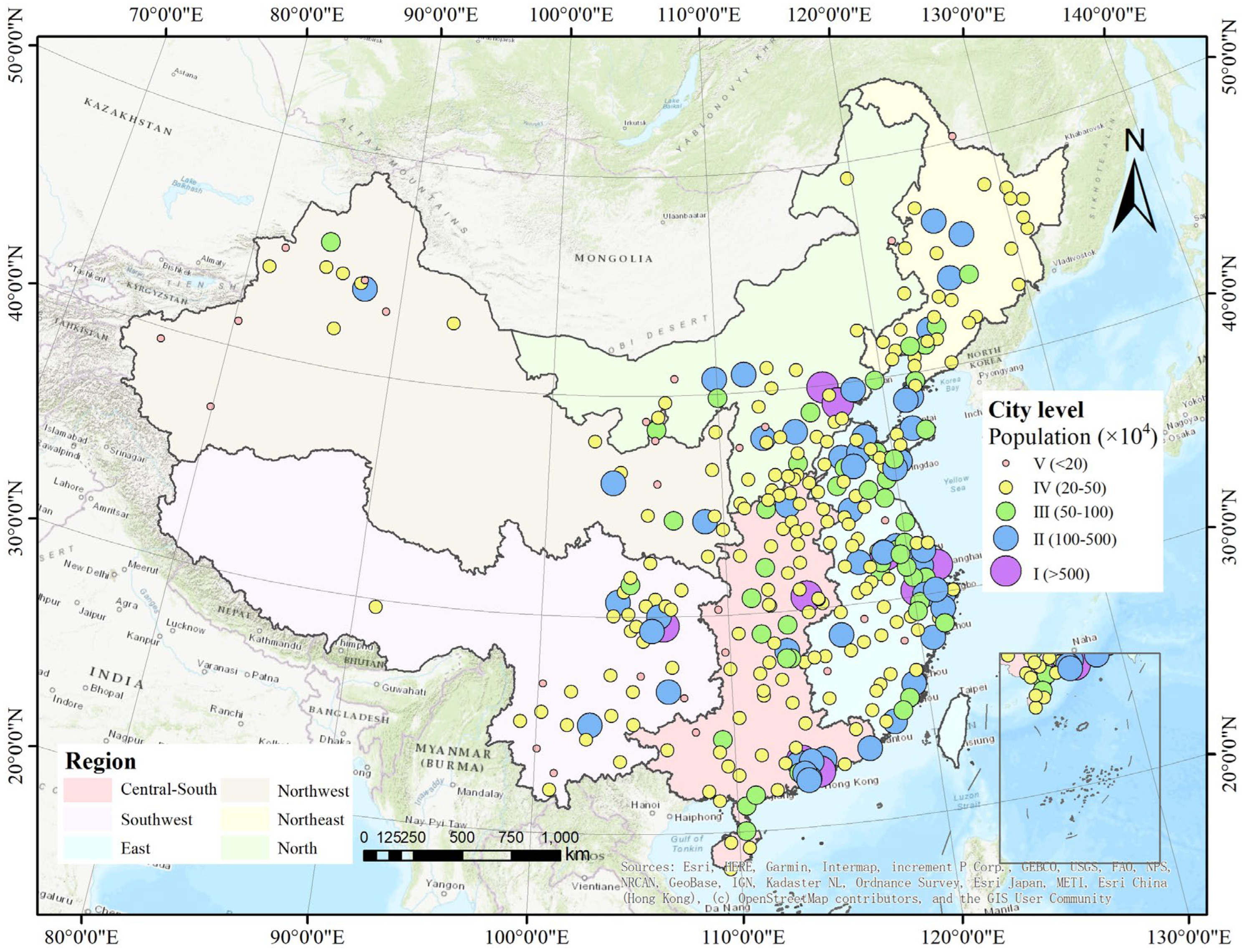
Figure 1. The spatial distribution of China’s 320 major cities in this study.
Remotesensing 16 02836 g001
Figure 2. Design and framework of the study. (a) Extraction of UGS coverage and calculation of trend; (b) schematic of the model to calculate the population exposed to different UGS coverage of the city; (c) driving analysis.
Remotesensing 16 02836 g002
Figure 3. (a) The spatial distribution of UGS coverage in 320 major cities in China. (b) A plot of the spatial distribution of the rate of change of UGS coverage in 320 cities. (c) A histogram of the frequency distribution of the slope of change in UGS coverage. (d) The trend in the national average of the UGS coverage. (e,f) Indicate the trends of UGS coverage in different regions and at different city levels, respectively.
Remotesensing 16 02836 g003
Figure 4. (a) Characteristics of spatial distribution of trends in proportion of areas with different UGS coverage classes in 320 cities: lowest (a), low (b), medium (c), high (d), and highest (e).
Remotesensing 16 02836 g004
Figure 5. Trends in the proportion of the areas in each class of UGS coverage and the proportion of urban population exposure to each UGS coverage class (a,d,g,j,m). Comparisons are made separately in terms of geographic location (b,e,h,k,n) and city size (c,f,i,l,o).
Remotesensing 16 02836 g005
Figure 6. The proportion of the areas in each UGS coverage class and the proportion of the population exposed to each UGS coverage class in different regions in 2000 and 2020.
Remotesensing 16 02836 g006
Figure 7. The proportion of the areas in each UGS coverage class and the proportion of the population exposed to each UGS coverage class in different city levels in 2000 and 2020.
Remotesensing 16 02836 g007
Figure 8. Multiple linear regression and variance decomposition. “-slope” indicates the slope of the change in each factor over the entire study period (2000–2020); asterisks represent statistical significance in this regression, *: p < 0.05, **: p < 0.01.
Remotesensing 16 02836 g008
Figure 9. Multiple linear regression and variance decomposition. “-slope” indicates the slope of the change in each factor over the rapid decline phase (2000–2014); asterisks represent statistical significance in this regression, *: p < 0.05, **: p < 0.01.
Remotesensing 16 02836 g009
Figure 10. Multiple linear regression and variance decomposition. “-slope” indicates the slope of the change in each factor over the progressive decline phase (2015–2020); asterisks represent statistical significance in this regression, *: p < 0.05, **: p < 0.01.
Remotesensing 16 02836 g010
Disclaimer/Publisher’s Note: The statements, opinions and data contained in all publications are solely those of the individual author(s) and contributor(s) and not of MDPI and/or the editor(s). MDPI and/or the editor(s) disclaim responsibility for any injury to people or property resulting from any ideas, methods, instructions or products referred to in the content.