Spatial Scale Effect on Fractional Vegetation Coverage Changes and Driving Factors in the Henan Section of the Yellow River Basin
Abstract
1. Introduction
2. Study Area and Data Sources
2.1. Study Area
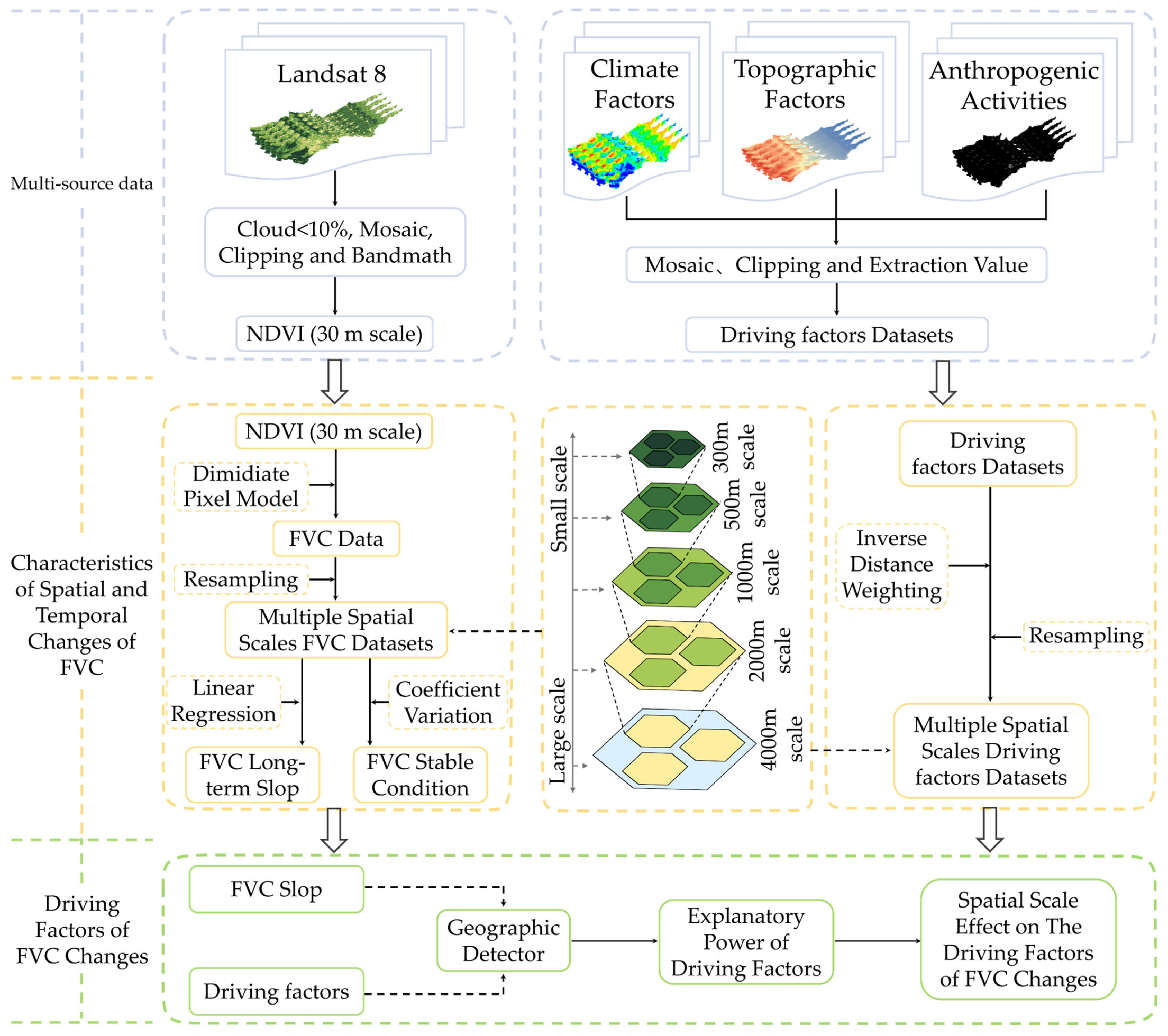
2.2. Data Sources
3. Methodology
3.1. Dimidiate Pixel Model
3.2. Linear Regression
3.3. Coefficient of Variation
3.4. Detection of Key Driving Factors
4. Results
4.1. Spatial and Temporal Change Characteristics of FVC at Different Spatial Scales
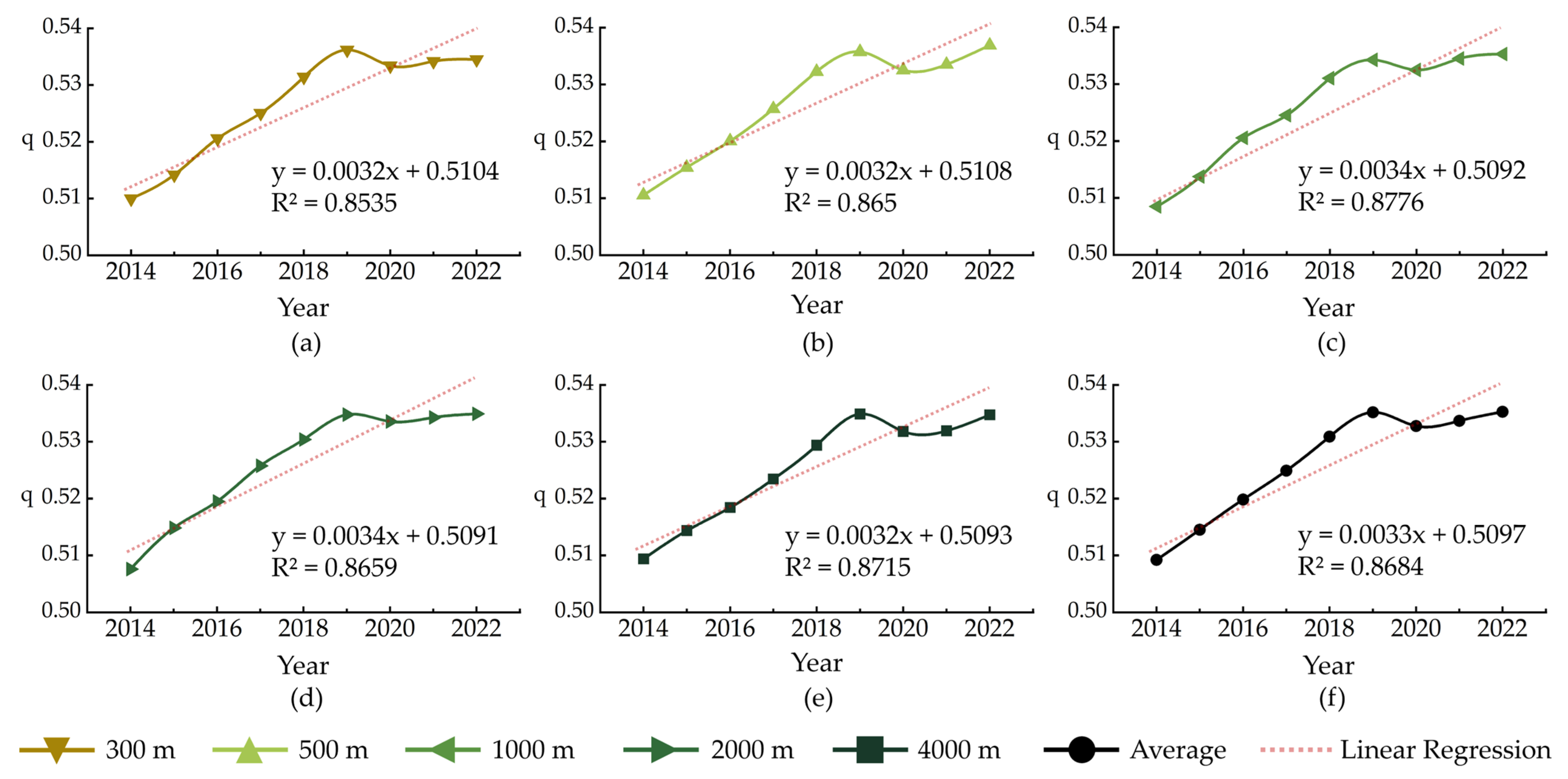
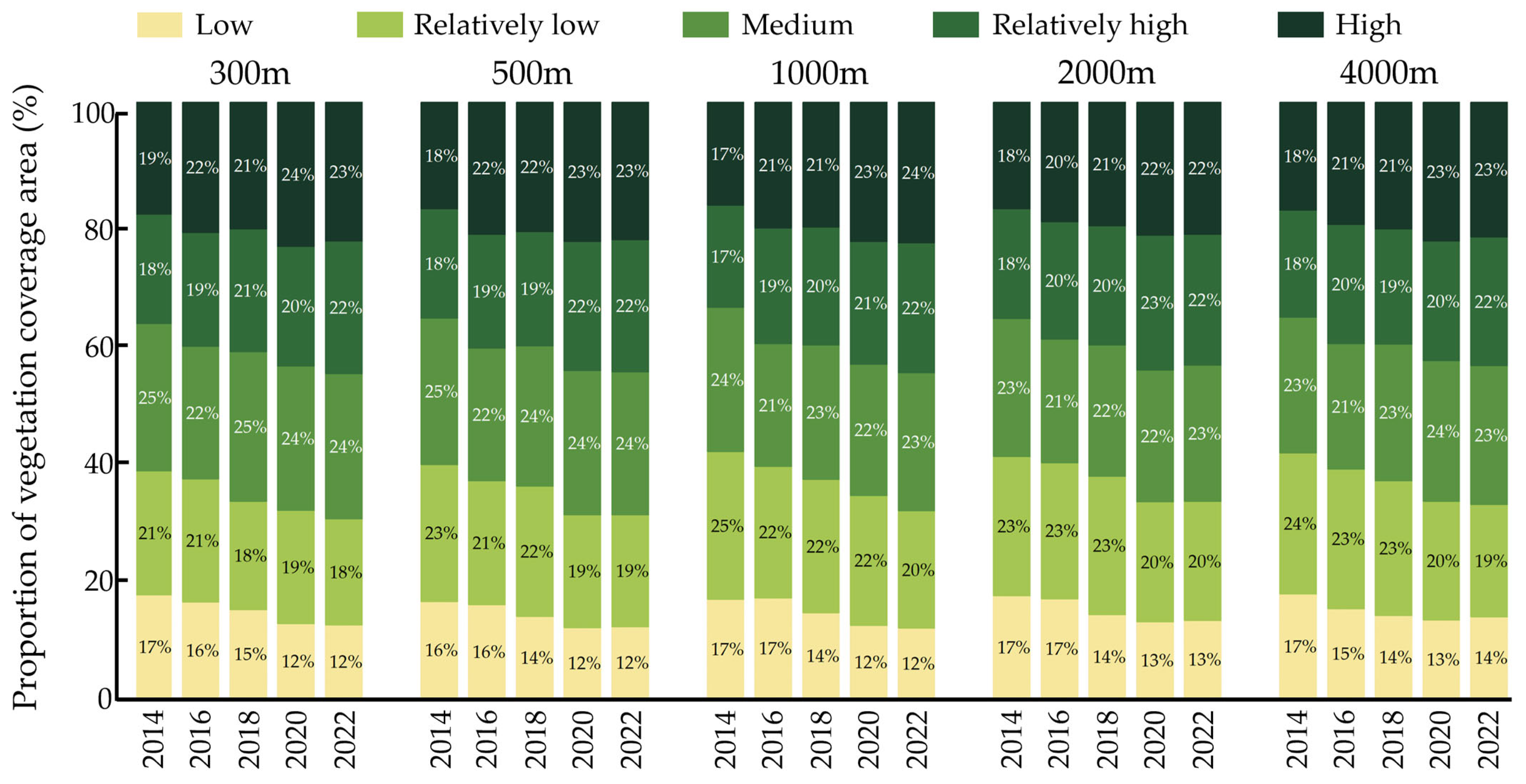
4.1.1. Temporal Change Characteristics of FVC at Multi-Spatial Scales
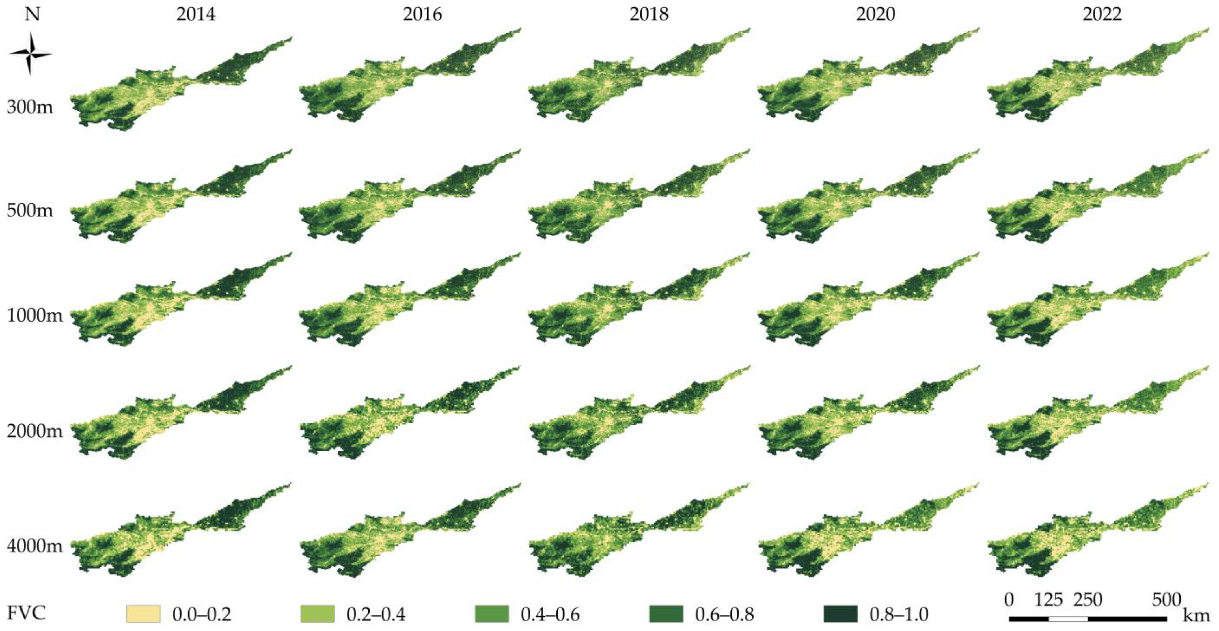
4.1.2. Spatial Change Characteristics of FVC at Multi-Spatial Scales
4.2. Driving Factors of FVC Changes at Different Spatial Scales
4.2.1. Independent Effects of Factors on FVC Changes at Multi-Spatial Scales
4.2.2. Interactive Effects of Factors on FVC Changes at Multi-Spatial Scales
5. Discussion
5.1. Effect of Anthropogenic Activities on the Spatio-Temporal Characteristics of FVC
5.2. Analysis of the Spatial Scale Effect on Topography Factors
5.3. Impact of Climate Factors at Different Spatial Scales
6. Conclusions
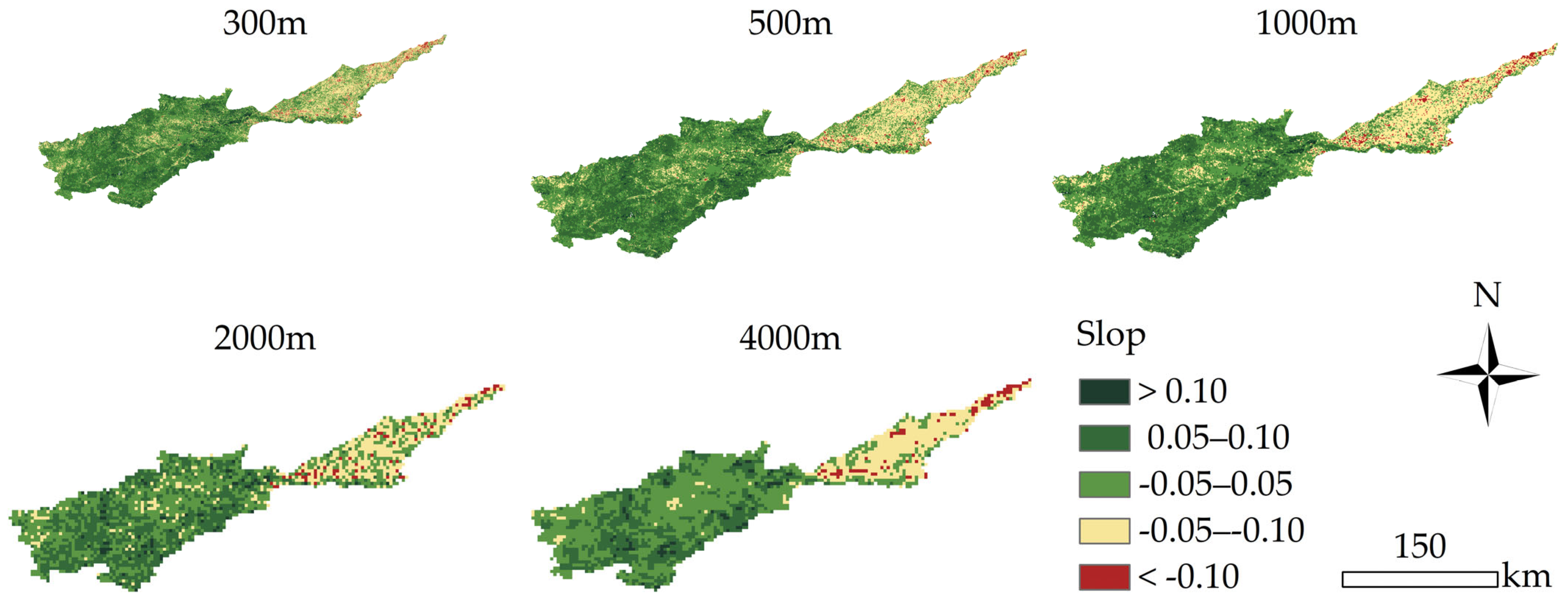
- The FVC showed an upward trend at all spatial scales, increasing by an average of 0.55% yr−1 from 2014 to 2022. The areas with an increasing trend in FVC were 10.83% more than those with a decreasing trend.
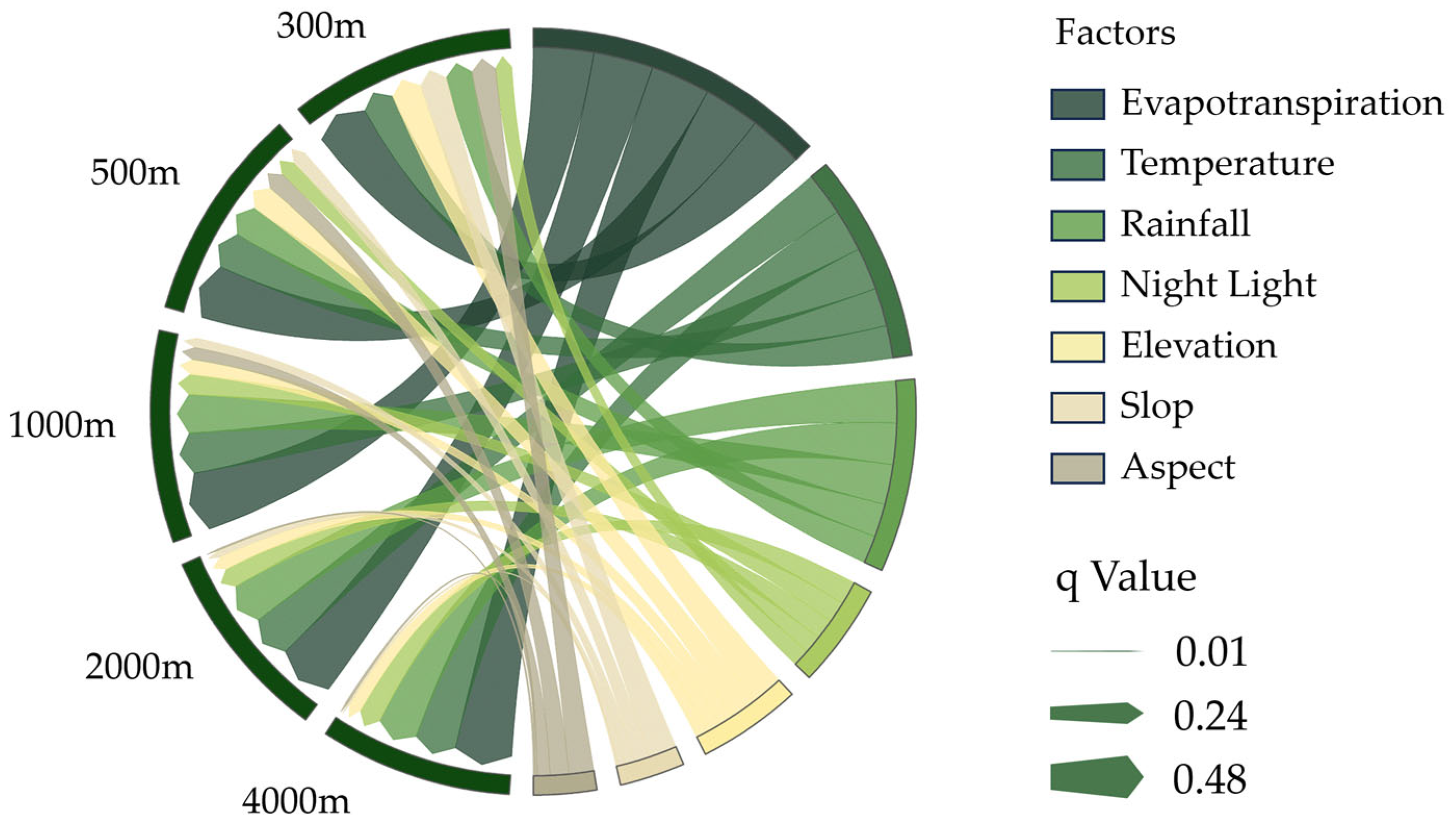
- The scale has a significant impact on the explanatory power of the driving factors of FVC. As the spatial scale increased, the explanatory power of the topography factors (aspect, elevation, and slope) for changes in FVC gradually strengthened, while the explanatory power of climate factors (evapotranspiration, temperature, and rainfall) and anthropogenic activities (night light) for changes in FVC decreased.
- The explanatory power of evapotranspiration was always the biggest across all spatial scales. The values of evapotranspiration peak notably at a spatial scale of 1000 m ( = 0.48), and the values of climate factors begin to stabilize when the spatial scale is reduced to 1000 m.
Author Contributions
Funding
Data Availability Statement
Conflicts of Interest
References
- Purevdorj, T.S.; Tateishi, R.; Ishiyama, T.; Honda, Y. Relationships between percent vegetation cover and vegetation indices. Int. J. Remote Sens. 1998, 19, 3519–3535. [Google Scholar] [CrossRef]
- Gao, Q.; Li, G.; Li, Z. Attribution of climate change and human activities to urban water level alterations and factors importance analysis in Central Taihu Basin. Urban Clim. 2021, 40, 101011. [Google Scholar] [CrossRef]
- Zhang, P.; Cai, Y.; Yang, W.; Yi, Y.; Yang, Z.; Fu, Q. Contributions of climatic and anthropogenic drivers to vegetation dynamics indicated by NDVI in a large dam-reservoir-river system. J. Clean. Prod. 2020, 256, 120477. [Google Scholar] [CrossRef]
- Ouyang, W.; Wan, X.; Xu, Y.; Wang, X.; Lin, C. Vertical difference of climate change impacts on vegetation at temporal-spatial scales in the upper stream of the Mekong River Basin. Sci. Total Environ. 2020, 701, 134782. [Google Scholar] [CrossRef] [PubMed]
- Wang, B.; Jia, K.; Wei, X.; Xia, M.; Yao, Y.; Zhang, X.; Liu, D.; Tao, G. Generating spatiotemporally consistent fractional vegetation cover at different scales using spatiotemporal fusion and multiresolution tree methods. ISPRS J. Photogramm. Remote Sens. 2020, 167, 214–229. [Google Scholar] [CrossRef]
- Qiu, H.; Zhang, J.; Han, H.; Cheng, X.; Kang, F. Study on the impact of vegetation change on ecosystem services in the Loess Plateau, China. Ecol. Indic. 2023, 154, 110812. [Google Scholar] [CrossRef]
- Cai, Y.; Zhang, F.; Duan, P.; Yung Jim, C.; Weng Chan, N.; Shi, J.; Liu, C.; Wang, J.; Bahtebay, J.; Ma, X. Vegetation cover changes in China induced by ecological restoration-protection projects and land-use changes from 2000 to 2020. CATENA 2022, 217, 106530. [Google Scholar] [CrossRef]
- Anatoly, G.; Yoram, K.; Robert, S.; Don, R. Novel algorithms for remote estimation of vegetation fraction. Remote Sens. Environ. 2002, 80, 76–87. [Google Scholar]
- Yang, S.; Song, S.; Li, F.; Yu, M.; Yu, G.; Zhang, Q.; Cui, H.; Wang, R.; Wu, Y. Vegetation coverage changes driven by a combination of climate change and human activities in Ethiopia, 2003–2018. Ecol. Inf. 2022, 71, 101776. [Google Scholar] [CrossRef]
- Chen, M.; Xue, Y.; Xue, Y.; Peng, J.; Guo, J.; Liang, H. Assessing the effects of climate and human activity on vegetation change in Northern China. Environ. Res. 2024, 247, 118233. [Google Scholar] [CrossRef]
- Guo, P.; Zhang, F.; Wang, H. The response of ecosystem service value to land use change in the middle and lower Yellow River: A case study of the Henan section. Ecol. Indic. 2022, 140, 109019. [Google Scholar] [CrossRef]
- Zhang, Y.; Zhang, P.; Liu, Z.; Xing, G.; Chen, Z.; Chang, Y.; Wang, Q. Dynamic analysis of soil erosion in the affected area of the lower Yellow River based on RUSLE model. Heliyon 2024, 10, e23819. [Google Scholar] [CrossRef] [PubMed]
- Duan, R.; Huang, G.; Zhou, X.; Lu, C.; Tian, C. Record-Breaking heavy rainfall around Henan Province in 2021 and future projection of extreme conditions under climate change. J. Hydrol. 2023, 625, 130102. [Google Scholar] [CrossRef]
- Ni, J.; Zhao, Y.; Li, B.; Liu, J.; Zhou, Y.; Zhang, P.; Shao, J.; Chen, Y.; Jin, J.; He, C. Investigation of the impact mechanisms and patterns of meteorological factors on air quality and atmospheric pollutant concentrations during extreme weather events in Zhengzhou city, Henan Province. Atmos. Pollut. Res. 2023, 14, 101932. [Google Scholar] [CrossRef]
- Xie, L.; Meng, X.; Zhao, X.; Fu, L.; Sharma, R.P.; Sun, H. Estimating Fractional Vegetation Cover Changes in Desert Regions Using RGB Data. Remote Sens. 2022, 14, 3833. [Google Scholar] [CrossRef]
- Bai, Y.; Li, S.; Liu, M.; Guo, Q. Assessment of vegetation change on the Mongolian Plateau over three decades using different remote sensing products. J. Environ. Manag. 2022, 317, 115509. [Google Scholar] [CrossRef]
- He, Z.; Yue, T.; Chen, Y.; Mu, W.; Xi, M.; Qin, F. Analysis of Spatial and Temporal Changes in Vegetation Cover and Driving Forces in the Yan River Basin, Loess Plateau. Remote Sens. 2023, 15, 4240. [Google Scholar] [CrossRef]
- He, C.; Yan, F.; Wang, Y.; Lu, Q. Spatiotemporal Variation in Vegetation Growth Status and Its Response to Climate in the Three-River Headwaters Region, China. Remote Sens. 2022, 14, 5041. [Google Scholar] [CrossRef]
- Yu, T.; Liu, P.; Zhang, Q.; Ren, Y.; Yao, J. Detecting Forest Degradation in the Three-North Forest Shelterbelt in China from Multi-Scale Satellite Images. Remote Sens. 2021, 13, 1131. [Google Scholar] [CrossRef]
- Taylor-Zavala, R.; Ramírez-Rodríguez, O.; de Armas-Ricard, M.; Sanhueza, H.; Higueras-Fredes, F.; Mattar, C. Quantifying Biochemical Traits over the Patagonian Sub-Antarctic Forests and Their Relation to Multispectral Vegetation Indices. Remote Sens. 2021, 13, 4232. [Google Scholar] [CrossRef]
- Fan, Q.; Shi, Y.; Song, X.; Cong, N. Study on Factors Affecting Remote Sensing Ecological Quality Combined with Sentinel-2. Remote Sens. 2023, 15, 2156. [Google Scholar] [CrossRef]
- Andreatta, D.; Gianelle, D.; Scotton, M.; Dalponte, M. Estimating grassland vegetation cover with remote sensing: A comparison between Landsat-8, Sentinel-2 and PlanetScope imagery. Ecol. Indic. 2022, 141, 109102. [Google Scholar] [CrossRef]
- Wang, H.; Yao, F.; Zhu, H.; Zhao, Y. Spatiotemporal Variation of Vegetation Coverage and Its Response to Climate Factors and Human Activities in Arid and Semi-Arid Areas: Case Study of the Otindag Sandy Land in China. Sustainability 2020, 12, 5214. [Google Scholar] [CrossRef]
- Weiss, J.L.; Gutzler, D.S.; Coonrod, J.E.A.; Dahm, C.N. Long-term vegetation monitoring with NDVI in a diverse semi-arid setting, central New Mexico, USA. J. Arid. Environ. 2004, 58, 249–272. [Google Scholar] [CrossRef]
- Al-Bakri, J.T.; Taylor, J.C. Application of NOAA AVHRR for monitoring vegetation conditions and biomass in Jordan. J. Arid. Environ. 2003, 54, 579–593. [Google Scholar] [CrossRef]
- Ghorbanian, A.; Mohammadzadeh, A.; Jamali, S. Linear and Non-Linear Vegetation Trend Analysis throughout Iran Using Two Decades of MODIS NDVI Imagery. Remote Sens. 2022, 14, 3683. [Google Scholar] [CrossRef]
- Dutta, D.; Das, P.K.; Paul, S.; Sharma, J.R.; Dadhwal, V.K. Assessment of ecological disturbance in the mangrove forest of Sundarbans caused by cyclones using MODIS time-series data (2001–2011). Nat. Hazard. 2015, 79, 775–790. [Google Scholar] [CrossRef]
- Otto, M.; Höpfner, C.; Curio, J.; Maussion, F.; Scherer, D. Assessing vegetation response to precipitation in northwest Morocco during the last decade: An application of MODIS NDVI and high resolution reanalysis data. Theor. Appl. Climatol. 2016, 123, 23–41. [Google Scholar] [CrossRef]
- Guo, S.; Wu, C.; Wang, Y.; Qiu, G.; Zhu, D.; Niu, Q.; Qin, L. Threshold effect of ecosystem services in response to climate change, human activity and landscape pattern in the upper and middle Yellow River of China. Ecol. Indic. 2022, 136, 108603. [Google Scholar] [CrossRef]
- Li, J.; Wang, J.; Zhang, J.; Liu, C.; He, S.; Liu, L. Growing-season vegetation coverage patterns and driving factors in the China-Myanmar Economic Corridor based on Google Earth Engine and geographic detector. Ecol. Indic. 2022, 136, 108620. [Google Scholar] [CrossRef]
- Chen, C.; Park, T.; Wang, X.; Piao, S.; Xu, B.; Chaturvedi, R.K.; Fuchs, R.; Brovkin, V.; Ciais, P.; Fensholt, R.; et al. China and India lead in greening of the world through land-use management. Nat. Sustain. 2019, 2, 122–129. [Google Scholar] [CrossRef] [PubMed]
- Hou, J.; Du, L.; Liu, K.; Hu, Y.; Zhu, Y. Characteristics of vegetation activity and its responses to climate change in desert/grassland biome transition zones in the last 30 years based on GIMMS3g. Theor. Appl. Climatol. 2019, 136, 915–928. [Google Scholar] [CrossRef]
- Feng, Y.; Su, H.; Tang, Z.; Wang, S.; Zhao, X.; Zhang, H.; Ji, C.; Zhu, J.; Xie, P.; Fang, J. Reduced resilience of terrestrial ecosystems locally is not reflected on a global scale. Commun. Earth Environ. 2021, 2, 88. [Google Scholar] [CrossRef]
- Yang, C.; Fu, M.; Feng, D.; Sun, Y.; Zhai, G. Spatiotemporal Changes in Vegetation Cover and Its Influencing Factors in the Loess Plateau of China Based on the Geographically Weighted Regression Model. Forests 2021, 12, 673. [Google Scholar] [CrossRef]
- Raja, N.; Aydin, O.; Çiçek, İ.; Türkoğlu, N. A reconstruction of Turkey’s potential natural vegetation using climate indicators. J. For. Res. 2019, 30, 2199–2211. [Google Scholar] [CrossRef]
- Chen, T.; Bao, A.; Jiapaer, G.; Guo, H.; Zheng, G.; Jiang, L.; Chang, C.; Tuerhanjiang, L. Disentangling the relative impacts of climate change and human activities on arid and semiarid grasslands in Central Asia during 1982–2015. Sci. Total Environ. 2019, 653, 1311–1325. [Google Scholar] [CrossRef] [PubMed]
- Zhang, Y.; Zhang, L.; Wang, J.; Dong, G.; Wei, Y. Quantitative analysis of NDVI driving factors based on the geographical detector model in the Chengdu-Chongqing region, China. Ecol. Indic. 2023, 155, 110978. [Google Scholar] [CrossRef]
- Wang, J.; Xu, C. Geodetector: Principle and prospective. Acta Geogr. Sin. 2017, 72, 116–134. [Google Scholar]
- Wang, J.; Li, X.; Christakos, G.; Liao, Y.; Zhang, T.; Gu, X.; Zheng, X. Geographical Detectors-Based Health Risk Assessment and its Application in the Neural Tube Defects Study of the Heshun Region, China. Int. J. Geogr. Inf. Sci. 2010, 24, 107–127. [Google Scholar] [CrossRef]
- Li, M.; Qin, Y.; Zhang, T.; Zhou, X.; Yi, G.; Bie, X.; Li, J.; Gao, Y. Climate Change and Anthropogenic Activity Co-Driven Vegetation Coverage Increase in the Three-North Shelter Forest Region of China. Remote Sens. 2023, 15, 1509. [Google Scholar] [CrossRef]
- Tao, S.; Peng, W.; Xiang, J. Spatiotemporal variations and driving mechanisms of vegetation coverage in the Wumeng Mountainous Area, China. Ecol. Inf. 2022, 70, 101737. [Google Scholar] [CrossRef]
- Huang, H.; Xi, G.; Ji, F.; Liu, Y.; Wang, H.; Xie, Y. Spatial and Temporal Variation in Vegetation Cover and Its Response to Topography in the Selinco Region of the Qinghai-Tibet Plateau. Remote Sens. 2023, 15, 4101. [Google Scholar] [CrossRef]
- Wang, C.; Wang, Y.; Li, J.; Guo, B. Spatio-temporal change patterns and its influencing factors of vegetation in the Yellow River Basin from 1981 to 2019. Sci. Surv. Mapp. 2023, 304, 136–146. [Google Scholar]
- Liu, L.; Wang, Y.; Wang, Z.; Li, D.; Zhang, Y.; Qin, D.; Li, S. Elevation-dependent decline in vegetation greening rate driven by increasing dryness based on three satellite NDVI datasets on the Tibetan Plateau. Ecol. Indic. 2019, 107, 105569. [Google Scholar] [CrossRef]
- Wu, W.; Liu, T.; Chen, X. Seasonal changes of NDVI in the arid and semi-arid regions of Northwest China and its influencing factors. Arid Zone Res. 2023, 40, 1969–1981. [Google Scholar]
- Guo, B.; Kong, W.; Jiang, L. Dynamic Monitoring of Ecological Vulnerability in Arid Desert Ecological Region of Northwest China and the Quantitative Analysis of Its Driving Forces. J. Nat. Resour. 2018, 33, 412–424. [Google Scholar]
- Guo, Z.; Wei, W.; Shi, P.; Zhou, L.; Wang, X.; Li, Z.; Pang, S.; Xie, B. Spatiotemporal changes of land desertification sensitivity in the arid region of Northwest China. Acta Geogr. Sin. 2020, 75, 1948–1965. [Google Scholar]
- Liu, L.; Wang, Z.; Wang, Y.; Zhang, Y.; Shen, J.; Qin, D.; Li, S. Trade-off analyses of multiple mountain ecosystem services along elevation, vegetation cover and precipitation gradients: A case study in the Taihang Mountains. Ecol. Indic. 2019, 103, 94–104. [Google Scholar] [CrossRef]
- A, D.; Zhao, W.; Qu, X.; Jing, R.; Xiong, K. Spatio-temporal variation of vegetation coverage and its response to climate change in North China plain in the last 33 years. Int. J. Appl. Earth Obs. Geoinf. 2016, 53, 103–117. [Google Scholar] [CrossRef]
- Wang, S.; Gao, M.; Li, Z.; Ma, J.; Peng, J. How Do Driving Factors Affect Vegetation Coverage Change in the Shaanxi Region of the Qinling Mountains? Remote Sens. 2024, 16, 160. [Google Scholar] [CrossRef]
- Safieh, J.; Saeid, E.; Kaveh, A. The analysis of the most important climatic parameters affecting performance of crop variability in a changing climate. Int. J. Hydrol. Sci. Technol. 2021, 11, 1–25. [Google Scholar]
- Shen, Q.; Gao, G.; Han, F.; Xiao, F.; Ma, Y.; Wang, S.; Fu, B. Quantifying the effects of human activities and climate variability on vegetation cover change in a hyper-arid endorheic basin. Land Degrad. Dev. 2018, 29, 3294–3304. [Google Scholar] [CrossRef]
- Wang, Z.; Xu, M.; Hu, H.; Zhang, X. Characteristics of vegetation changes and their drivers in the Yellow River basin from 1982 to 2020. Adv. Water Sci. 2023, 34, 499–509. [Google Scholar]
- Xu, Y.; Hao, S.; Cui, Y.; Li, P.; Sheng, L.; Liao, C. Analysis of the spatiotemporal expansion and pattern evolution of urban areas in Anhui Province, China, based on nighttime light data. Ecol. Indic. 2023, 157, 111283. [Google Scholar] [CrossRef]
- Baydogan, E.; Sarp, G. Urban footprint detection from night light, optical and SAR imageries: A comparison study. Remote Sens. Appl. Soc. Environ. 2022, 27, 100775. [Google Scholar] [CrossRef]
- Wang, C.; Liu, S.; Zhou, S.; Zhou, J.; Jiang, S.; Zhang, Y.; Feng, T.; Zhang, H.; Zhao, Y.; Lai, Z.; et al. Spatial-temporal patterns of urban expansion by land use/ land cover transfer in China. Ecol. Indic. 2023, 155, 111009. [Google Scholar] [CrossRef]
- Wei, H.; Wang, Y.; Liu, J.; Zhang, J.; Cao, Y. Coordinated development of cultivated land use and ecological protection in cities along the main stream of the Yellow River in Henan Province, China. Ecol. Indic. 2023, 156, 111143. [Google Scholar] [CrossRef]
- Ma, S.; Qiao, Y.-P.; Jiang, J.; Wang, L.-J.; Zhang, J.-C. Incorporating the implementation intensity of returning farmland to lakes into policymaking and ecosystem management: A case study of the Jianghuai Ecological Economic Zone, China. J. Clean. Prod. 2021, 306, 127284. [Google Scholar] [CrossRef]
- Zinda, J.A.; Trac, C.J.; Zhai, D.; Harrell, S. Dual-function forests in the returning farmland to forest program and the flexibility of environmental policy in China. Geoforum 2017, 78, 119–132. [Google Scholar] [CrossRef]
- Cai, E.; Zhang, S.; Chen, W.; Li, L. Spatio–temporal dynamics and human–land synergistic relationship of urban expansion in Chinese megacities. Heliyon 2023, 9, e19872. [Google Scholar] [CrossRef]
- Fan, L.; Cai, T.; Wen, Q.; Han, J.; Wang, S.; Wang, J.; Yin, C. Scenario simulation of land use change and carbon storage response in Henan Province, China: 1990–2050. Ecol. Indic. 2023, 154, 110660. [Google Scholar] [CrossRef]
- Cheng, Z.; Yang, X.; Dong, S.; Sun, C.; Wu, Y. Vegetation Coverage Changes in Chengdu Based on DMSP/OLS and SPOT-VEG NDVI. Adv. Meteorol. Sci. Technol. 2016, 6, 14–20. [Google Scholar]
- Zhang, L.; Wang, F.; Song, H.; Zhang, T.; Wang, D.; Xia, H.; Zhai, S.; Liu, Y.; Wang, T.; Wang, Y.; et al. Effects of projected climate change on winter wheat yield in Henan, China. J. Clean. Prod. 2022, 379, 134734. [Google Scholar] [CrossRef]
- Liu, Y.; Huang, T.; Qiu, Z.; Guang, Z.; Ma, X. Effects of precipitation changes on fractional vegetation cover in the Jinghe River basin from 1998 to 2019. Ecol. Inf. 2024, 80, 102505. [Google Scholar] [CrossRef]
- Wen, B.; Huang, C.; Zhou, C.; Zhang, H.; Yang, Q.; Liu, M. Spatiotemporal dynamics and driving factors of soil erosion in the Beiluo River Basin, Loess Plateau, China. Ecol. Indic. 2023, 155, 110976. [Google Scholar] [CrossRef]

| Data Name | Data Products | Unit | Resolution | Data Sources |
|---|---|---|---|---|
| FVC | Landsat-8 Surface Reflectance Tier 1 (Dimidiate Pixel Model) | - | 30 m | Google Earth Engine (https://earthengine.google.com/, accessed on 10 December 2023) |
| Aspect | NASADEM | ° | 30 m | EARTHDATA (http://www.earthdata.nasa.gov/, accessed on 10 December 2023) |
| Elevation | NASADEM | m | 30 m | EARTHDATA (http://www.earthdata.nasa.gov/, accessed on 10 December 2023) |
| Evapotranspiration | Landsat-8 Surface Reflectance Tier 1 (Surface Energy Balance Algorithm for Land Model) | mm | 100 m | Google Earth Engine (https://earthengine.google.com/, accessed on 10 December 2023) |
| Nightlights | SVDNB | - | 500 m | Earth Observation Group (https://eogdata.mines.edu/, accessed on 10 December 2023) |
| Rainfall | China Meteorological Dataset | mm | 1 km | Resource and Environmental Science Data Platform (https://www.resdc.cn/, accessed on 10 December 2023) |
| Slope | NASADEM | ◦ | 30 m | EARTHDATA (http://www.earthdata.nasa.gov/, accessed on 10 December 2023) |
| Temperature | Landsat-8 Surface Reflectance Tier 1 | °C | 30 m | Google Earth Engine (https://earthengine.google.com/, accessed on 10 December 2023) |
| Vegetation Cover | Classification Criteria |
|---|---|
| Low | 0 ≤ FVC < 0.2 |
| Relatively Low | 0.2 ≤ FVC < 0.4 |
| Medium | 0.4 ≤ FVC < 0.6 |
| Relatively High | 0.6 ≤ FVC < 0.8 |
| High | 0.8 ≤ FVC < 1 |
| Interaction | Criterion of Interval |
|---|---|
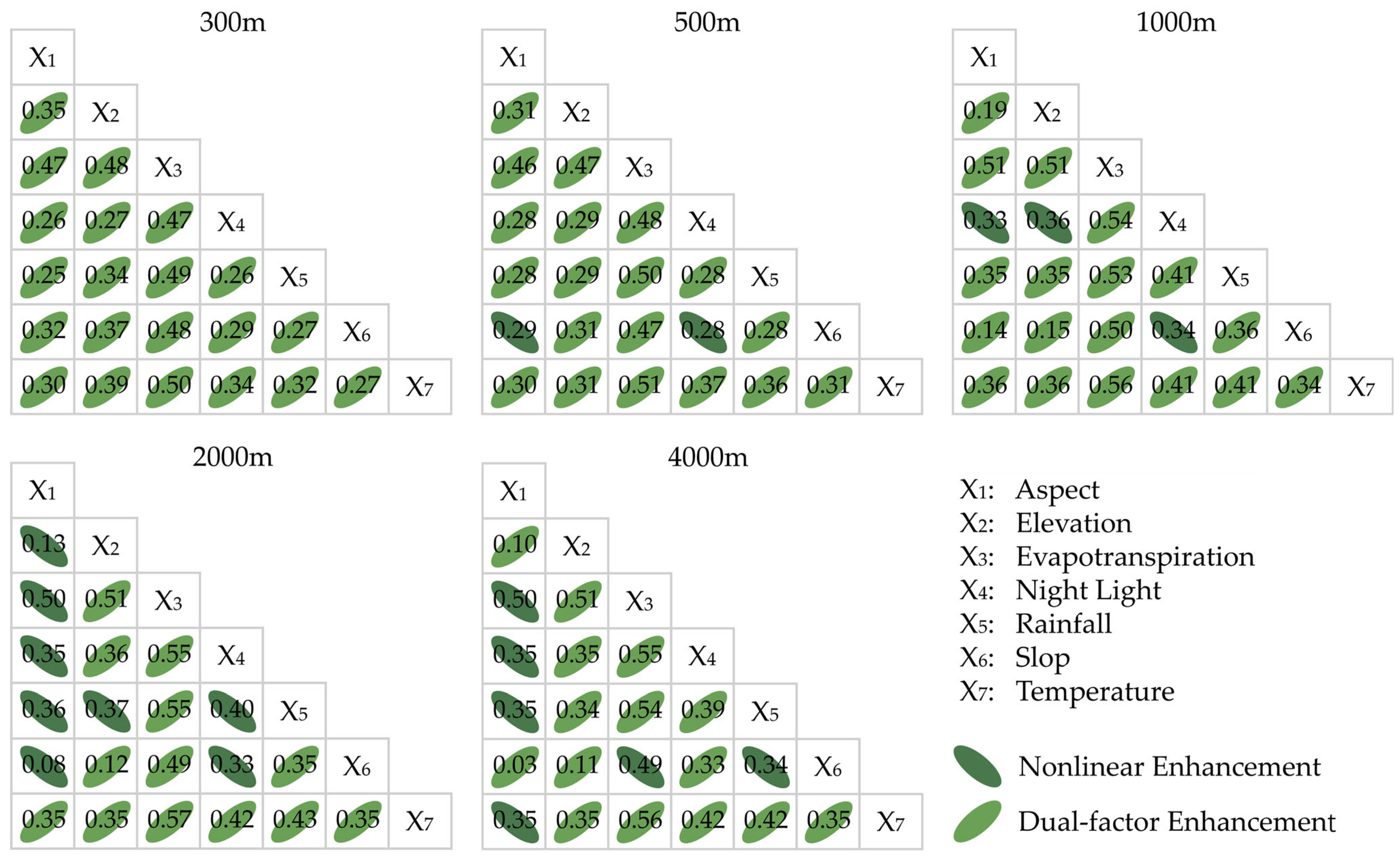
| Nonlinear Weakening | q(X1∩X2) < Min [q(X1), q(X2)] |
| Single-factor Nonlinear Weakening | Min[q(X1), q(X2)] < q(X1∩X2) < Max [q(X1), q(X2)] |
| Dual-factor Enhancement | q(X1∩X2) > Max [q(X1), q(X2)] |
| Independent | q(X1∩X2) = q(X1) + q(X2) |
| Nonlinear Enhancement | q(X1∩X2) > q(X1) + q(X2) |
| Class | Classification Criteria |
|---|---|
| Significant Degradation | slop < −0.1 |
| Slight Degradation | −0.1 ≤ slop < −0.05 |
| Essentially Stable | −0.05 ≤ slop < 0.05 |
| Slight Improvement | 0.05 ≤ slop < 0.1 |
| Significant Improvement | slop > 0.1 |
| Class | Classification Criteria |
|---|---|
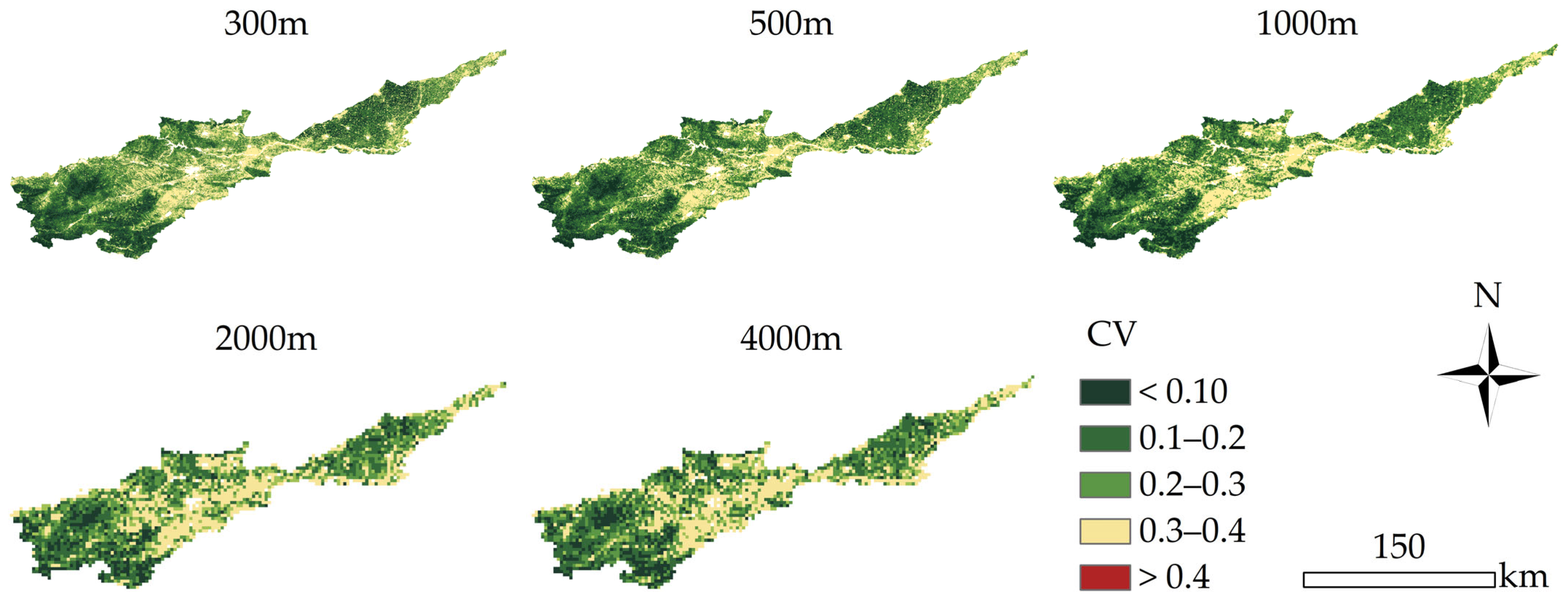
| Low variation | ≤ 0.10 |
| Relatively low variation | ≤ 0.20 |
| Medium variation | ≤ 0.30 |
| Relatively high variation | ≤ 0.40 |
| High variation | > 0.40 |
| Scale (m) | Aspect | Elevation | Slope | Temperature |
|---|---|---|---|---|
| 300 | 0.192 | 0.241 | 0.217 | 0.253 |
| 500 | 0.146 | 0.203 | 0.116 | 0.295 |
| 1000 | 0.098 | 0.119 | 0.076 | 0.327 |
| 2000 | 0.012 | 0.107 | 0.055 | 0.336 |
| 4000 | 0.018 | 0.099 | 0.018 | 0.330 |
| Scale (m) | Evapotranspiration | Rainfall | Temperature | Nightlights |
|---|---|---|---|---|
| 300 | 0.429 | 0.214 | 0.253 | 0.231 |
| 500 | 0.442 | 0.255 | 0.295 | 0.266 |
| 1000 | 0.476 | 0.311 | 0.327 | 0.304 |
| 2000 | 0.461 | 0.325 | 0.336 | 0.311 |
| 4000 | 0.450 | 0.320 | 0.330 | 0.318 |
Disclaimer/Publisher’s Note: The statements, opinions and data contained in all publications are solely those of the individual author(s) and contributor(s) and not of MDPI and/or the editor(s). MDPI and/or the editor(s) disclaim responsibility for any injury to people or property resulting from any ideas, methods, instructions or products referred to in the content. |
© 2024 by the authors. Licensee MDPI, Basel, Switzerland. This article is an open access article distributed under the terms and conditions of the Creative Commons Attribution (CC BY) license (https://creativecommons.org/licenses/by/4.0/).
Share and Cite
Wang, R.; Wang, H.; Wang, C.; Duan, J.; Zhang, S. Spatial Scale Effect on Fractional Vegetation Coverage Changes and Driving Factors in the Henan Section of the Yellow River Basin. Remote Sens. 2024, 16, 2575. https://doi.org/10.3390/rs16142575
Wang R, Wang H, Wang C, Duan J, Zhang S. Spatial Scale Effect on Fractional Vegetation Coverage Changes and Driving Factors in the Henan Section of the Yellow River Basin. Remote Sensing. 2024; 16(14):2575. https://doi.org/10.3390/rs16142575
Chicago/Turabian StyleWang, Rongxi, Hongtao Wang, Cheng Wang, Jingjing Duan, and Shuting Zhang. 2024. "Spatial Scale Effect on Fractional Vegetation Coverage Changes and Driving Factors in the Henan Section of the Yellow River Basin" Remote Sensing 16, no. 14: 2575. https://doi.org/10.3390/rs16142575
APA StyleWang, R., Wang, H., Wang, C., Duan, J., & Zhang, S. (2024). Spatial Scale Effect on Fractional Vegetation Coverage Changes and Driving Factors in the Henan Section of the Yellow River Basin. Remote Sensing, 16(14), 2575. https://doi.org/10.3390/rs16142575


