Article

Tracking Loop Current Eddies in the Gulf of Mexico Using Satellite-Derived Chlorophyll-a

1
Naval Research Laboratory, Stennis Space Center, Hancock County, MS 39529, USA
2
School of the Earth, Ocean and Environment, University of South Carolina, Columbia, SC 29208, USA
3
Center for Ocean-Atmospheric Prediction Studies, Florida State University, Tallahassee, FL 32310, USA
4
Department of Scientific Computing, Florida State University, Tallahassee, FL 32301, USA
*
Author to whom correspondence should be addressed.
Remote Sens. 2024, 16(12), 2234; https://doi.org/10.3390/rs16122234
Submission received: 13 May 2024 / Revised: 12 June 2024 / Accepted: 17 June 2024 / Published: 19 June 2024

Abstract

:
During the period of 2018–2022, there were six named Loop Current Eddy (LCE) shedding events in the central Gulf of Mexico (GoM). LCEs form when a large anticyclonic eddy (AE) separates from the main Loop Current (LC) and propagates westward. In doing so, each LCE traps and advects warmer, saltier waters with lower Chlorophyll-a (Chl-a) concentrations than the surrounding Gulf waters. This difference in water mass permits the study of the effectiveness of using Chl-a from satellite-derived ocean color to identify LCEs in the GoM. In this work, we apply an eddy-tracking algorithm to Chl-a to detect LCEs, which we have validated against the traditional sea surface height-(SSH) based eddy-tracking approach with three datasets. We apply a closed-contour eddy-tracking algorithm to the SSH of two model products (HYbrid Coordination Ocean Model; HYCOM and Nucleus for European Modelling of the Ocean; NEMO) and absolute dynamic topography (ADT) from altimetry, as well as satellite-derived Chl-a data to identify the six named LCEs from 2018 to 2022. We find that Chl-a best characterizes LCEs in the summertime due to a basin-wide increase in the horizontal gradient of Chl-a, which permits a more clearly defined eddy edge. This study demonstrates that Chl-a can be effectively used to identify and track LC and LCEs in the GoM, serving as a promising source of information for regional data assimilative models.

Graphical Abstract

1. Introduction

The Gulf of Mexico (GoM) is a semi-enclosed sea whose circulation is dominated by the Loop Current (LC) and its associated eddies. Water flows northward through the Yucatan Channel into the Gulf, loops anticyclonically, and exits eastward through the Straits of Florida, ultimately feeding into the southernmost point of the Gulf Stream [1]. When the LC is in its extended position penetrating northward towards the Mississippi, Alabama, and Florida (MAFLA) Shelf, it becomes unstable and sheds an anticyclonic eddy, called a Loop Current Eddy (LCE), that propagates westward towards Mexico [2,3,4]. Hall et al. [5] used automated LC tracking techniques to derive LCE separation dates from three altimetry sea surface height (SSH) data sets during 1993–2012 and found notable seasonal LCE separation peaks in August and September, with secondary peaks in February and March. LCE separation events occurred near the spring and fall equinoxes. After an LCE sheds, the LC retreats to its retracted state and a new cycle can start [6]. Thus, the LC configuration is highly variable, transitioning between extended, shedding, and retracted positions.
The LC is commonly identified using the SSH contour value of 17 cm, which closely aligns with the maximum SSH gradient and approximates the high-velocity core of the LC front [7]. The LC is responsible for transporting an average of 27.6 Sv of water into and out of the Gulf [8]. Because eddies contribute to mass transport at rates comparable to the mean circulation [9], the LC’s associated eddy field transports nearly as much water within the basin. Therefore, understanding the movement and characteristics of the eddy field is integral to understanding the circulation and physical properties that govern the Gulf.
The warm waters of the LC and LCEs often serve as an energy source for tropical cyclones to rapidly intensify as they approach landfall in the southeastern United States [10]. Therefore, it is important to fully understand and be able to forecast their changing position. However, LCE-shedding events are incredibly complex and occur at irregular intervals ranging from a few weeks to over a year [5,11]. Chlorophyll response is nutrient-dependent, is observable for several days in regions of upwelling, and can degrade rapidly when nutrients are depleted. These nutrient changes modify the magnitude of the chlorophyll concentration [12].
Due to the recent ocean warming [13], SST increases when compared with historical temperatures; this increase is weaker during winter (December to February) in the GoM due to the strengthened northerly winds and increased vertical mixing, which deepens the mixed later and carries cold, nutrient-rich water to surface [14]. October has a larger rate of increase in SST than in January [15]. Wang et al. [13] showed that the GoM increased by ~1 °C between 1970 and 2020 (0.19 °C per decade), twice the rate of the global ocean during this period. Though warming occurred at all depths, the largest warming was in the upper 50 m. Sturges and Evans [16] suggest that the northward maximum penetration of LC happens in winter and summer periods. Enhanced Chl-a concentrations in anticyclonic eddies during winter are associated with vertical fluxes driven by Ekman transport divergence as explained in [15,17,18,19,20], which then leads to a wind stress curl of the opposite sign to the curl of the ocean motion. Consequently, wind forcing can lead to Ekman pumping inside anticyclonic eddies (and the opposite in cyclonic eddies). Mixed layer depths are deeper in anticyclonic eddies than cyclonic eddies and vertical nutrients are enhanced in euphotic layers in winter [21,22]. Mayot et al. [23] described that the winter increase in horizontal gradient may be due to physiological mechanisms (modification of the ratio of the Chl-a) rather than changes in the biomass.
Surface Chl-a concentration inferred from satellites can be used to track mesoscale activity and biogeochemical variability in oligotrophic regions like the GoM. Anticyclonic LCEs are shed episodically and travel westward [24]. Previous studies have noted that the LC and LCEs have a negative Chl-a anomaly compared to the surrounding [25,26,27]. However, as we will show in this manuscript, this is only the case during certain periods of the year. In winter, anomalous biomass increases in the LCEs due to winter convective mixing that reaches deeper nutrient-rich water [28], and the LCEs cannot be visually identified using ocean color.
Previous studies have used different methods to identify the LCEs, such as the 17 cm SSH contour [29] and Lagrangian coherence boundary for the LCEs [26]. In this study, we show that Chlorophyll data can provide information about the location of the LC and LCEs. This is an important finding as there are current discussions in the oceanographic community on the advantages of assimilating Chlorophyll data in numerical models (HYCOM in particular) to improve the location of the LC and LCEs and potentially improve LCE shedding forecast. We show that ocean color can be used solely, without the aid of SSH or other variables, to identify and track LCEs as well as other smaller eddies in the Gulf of both circulation types. We apply an eddy-tracking method to numerical simulations (HYCOM, NEMO), altimetry, and Chl-a to track LCEs and understand the biophysical interactions. We have validated the results against the traditional SSH-based eddy-tracking approach in three datasets: HYCOM, NEMO, and altimetry. The results suggest that Chl-a can be used on its own during summer and fall to track LCEs but would still require an SSH/ADT approach for spring and winter tracking.

2. Data and Methods

2.1. Satellite Data

Daily Chlorophyll-a is obtained from the National Oceanic and Atmospheric Administration’s (NOAA’s) three-sensor global Ocean Color Chl-a global gap-filled 9 km analysis that utilizes the data interpolating empirical orthogonal function (DINEOF) method described in [30]. The data is obtained from observations by the Visible Infrared Imaging Radiometer Suite (VIIRS) sensors aboard the Suomi National Polar-orbiting Partnership (SNPP) and NOAA-20 satellites in conjunction with the Ocean Land and Color Instrument (OLCI) on Sentinel 3A. Data is available at a 9 km spatial resolution, and this product’s lack of spatial gaps permits the cohesive identification of mesoscale eddies using the methodology described in Section 2.3. However, though there are many sensors utilized in this product, the effect of DINEOF-induced smoothing of gaps due to cloud cover may also smooth the Chl-a gradient, which is thus identified as a limitation of this dataset. This dataset begins on 9 February 2018 and thus constrains our period of study (https://coastwatch.star.nesdis.noaa.gov/pub/socd1/mecb/coastwatch/viirs/science/L3/global/chlora/dineof3/, accessed on 5 March 2024) as well as the length of time used to compute the spatial averages shown Figure 1. Both Figure 1 and Figure 2 are derived from daily data files, though Figure 2 only shows the monthly average throughout 2019.
Daily absolute dynamic topography (ADT) is globally available via the Copernicus Marine Service, CMEMS (https://marine.copernicus.eu/, accessed on 17 July 2023), from December 1992 through June 2023 at a 0.25° spatial resolution. ADT in this product is the sum of sea level anomaly and the mean sea surface height above the Geoid. While SLA fields resolve transient eddies, ADT fields also represent stationary, climatologically occurring eddies that can be generated by bathymetric features such as seamounts or islands [31]. For this reason, ADT is generally considered to be a marginally better product for mesoscale eddy identification [32,33,34].

2.2. Model Simulations

Two daily numerical ocean models were used to compare the identified eddies through sea surface height (SSH): the HYbrid Coordinate Ocean Model (HYCOM) (https://www.hycom.org/data/gomb0pt04/gom-reanalysis, accessed on 17 April 2023) and Nucleus for European Modelling of the Ocean (NEMO). The HYCOM configuration is a GoM-only 1/25° horizontal resolution with 41 vertical hybrid layers and five tidal constituents (M2, S2, O1, K1, N2) and CFSv2 atmospheric forcing. HYCOM uses the Navy Coupled Ocean Data Assimilation (NCODA) [35]. NCODA assimilates satellite altimeter observations, in situ vertical temperature, and salinity profiles from expendable bathythermographs, moored buoys, and Argo floats. Improved Synthetic Ocean Profiles (ISOP; [36]) are used to project surface information downward. The NEMO product has a 1/12° horizontal resolution with 50 vertical z-levels that is atmospherically driven at the surface by ECMWF’s ERA5 reanalysis that integrates along-track altimeter date, satellite SST, sea ice concentration, and in situ temperature and salinity profiles via a reduced-order Kalman filter (ftp://nrt.cmems-du.eu/Core/GLOBAL_ANALYSIS_FORECAST_PHY_001_024/global-analysis-forecast-phy-001-024, accessed on 17 July 2023).

2.3. Methodology

To identify mesoscale eddies, the eddy-tracking algorithm described in [37,38,39,40] was applied to each product (satellite ADT, HYCOM and NEMO SSH, and satellite Chl-a), which produces a more accurate eddy shape than the method used by [41] and generally better results than the Okubo–Weiss approach as found by [42,43]. First, local minima and maxima were identified on each daily map to define the eddy centers. Next, the largest surrounding closed contour was found to define the eddy edges. A cost function was applied in between timesteps (in this case of length one day) to follow the path of the most statistically similar eddy throughout its full trajectory. The cost function can be found in more detail in [44]. Amplitudes are defined as the absolute value of the difference in value between the center and edge. Radii represents the value (in km) that produces the same area as that integrated within each eddy edge. Chl-a anomaly is averaged over the pixels within each identified eddy for time series plots. The minimum eddy size, as constrained by the spatial resolution of the coarsest product (CMEMS altimetry ADT), is 25 km, well below the standard size of LCEs. Application of this methodology to surface topography is well-recorded, though direct application to satellite-derived Chlorophyll-a (Chl-a) is a novel component of this study. The multi-year availability of gap-filled ocean color Chl-a data permits the application of the eddy-tracking algorithm to determine if any additional information regarding eddy characteristics is gained via this new approach, expounded upon in Section 3 and Section 4.
The nomenclature of major defined LCEs for the period of 2018–2022 is defined by that of the Woods Hole Group (https://www.horizonmarine.com/, accessed on 30 April 2024) and its EddyWatch program. The LCEs in question in this study are Revelle, Sverdrup, Thor, Wilde, Wilde II, and X. Chlorophyll-a anomalies within eddies are defined as the difference between the average Chl-a within the eddy edge (0–1 radii) and the average Chlorophyll-a outside of the eddy edge (1–1.5 radii).

3. Results

3.1. Loop Current Identification

Climatological surface characteristics of sea surface height (SSH) and Chl-a concentration in the Gulf of Mexico (GoM) are governed by the Loop Current (LC) and riverine inputs. The mean LC position is represented by elevated SSH values in the southeastern basin (Figure 1). HYCOM and NEMO SSH simulations display a wider LC than satellite altimetry, extending to 27°N and a more active eddy field in the western GoM. Climatological Chl-a concentration is highest at the coast where nutrient-rich fresh waters enter the basin from river output. Waters entering from the Caribbean Sea via Loop Current are oligotrophic compared to surrounding Gulf Waters; therefore, GoM open waters are largely nutrient deficient (Figure 1).
Changes in wind-induced coastal circulation and convective mixing by cold weather events contribute to Chl-a increases. During winter months (December–February), waters are cooler, and hence, convective mixing and Ekman suction bring deep, nutrient-rich water to surfaces that increase Chl-a (Figure 2). During July and August, a slight increase in Chl-a is present near coastal regions mainly due to the dispersal of Mississippi Delta waters and an increase in nutrients [45]. The LC and LCE possess low Chl-a compared to their surroundings, which is exacerbated during summertime, making the features more distinguishable and identifiable. Also, the location of the 17 cm contour aligns well with the large Chl-a gradient along the LC and LCE fronts.

3.2. Daily Eddy Characteristics Using Eddy-Tracking Algorithm

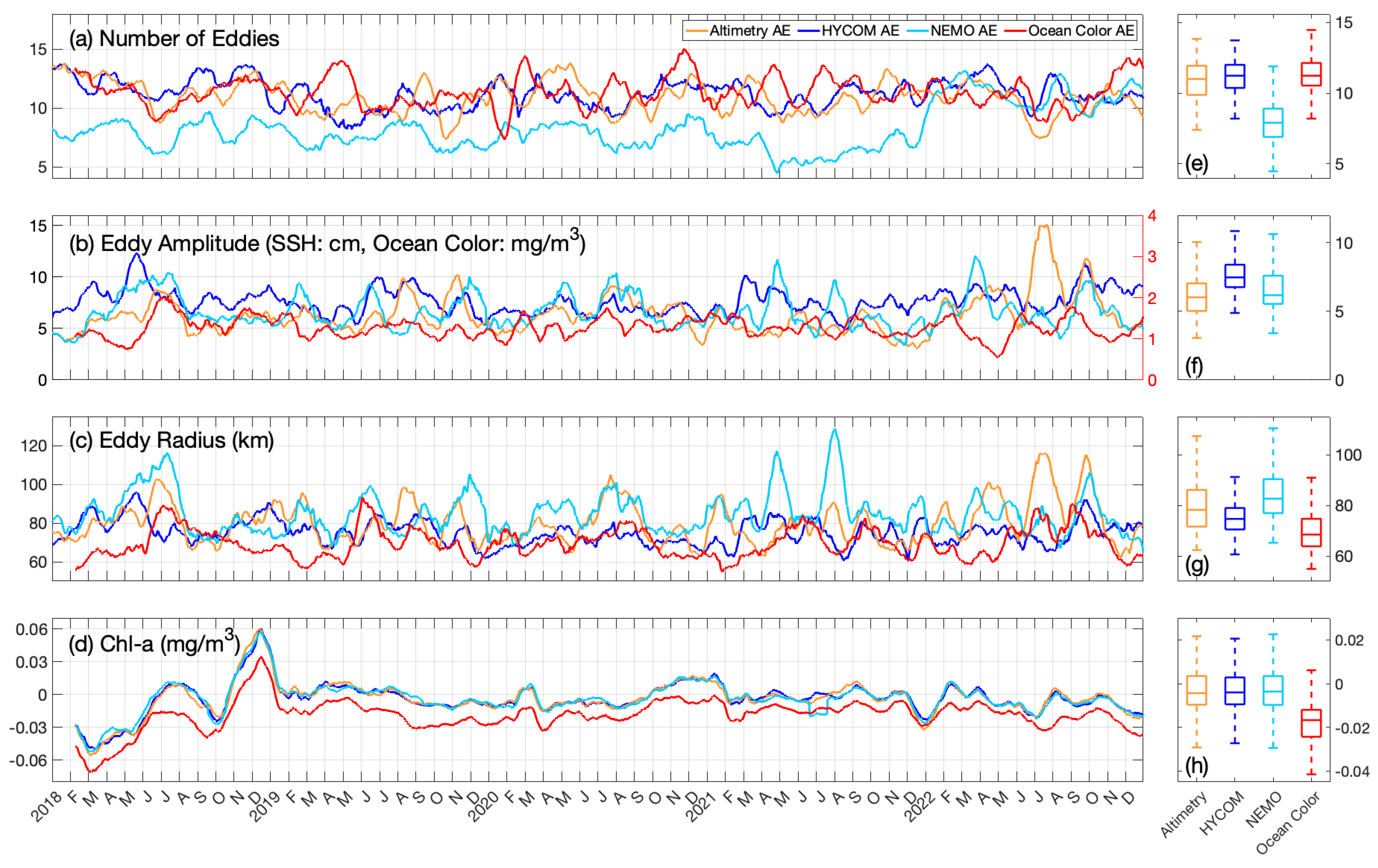
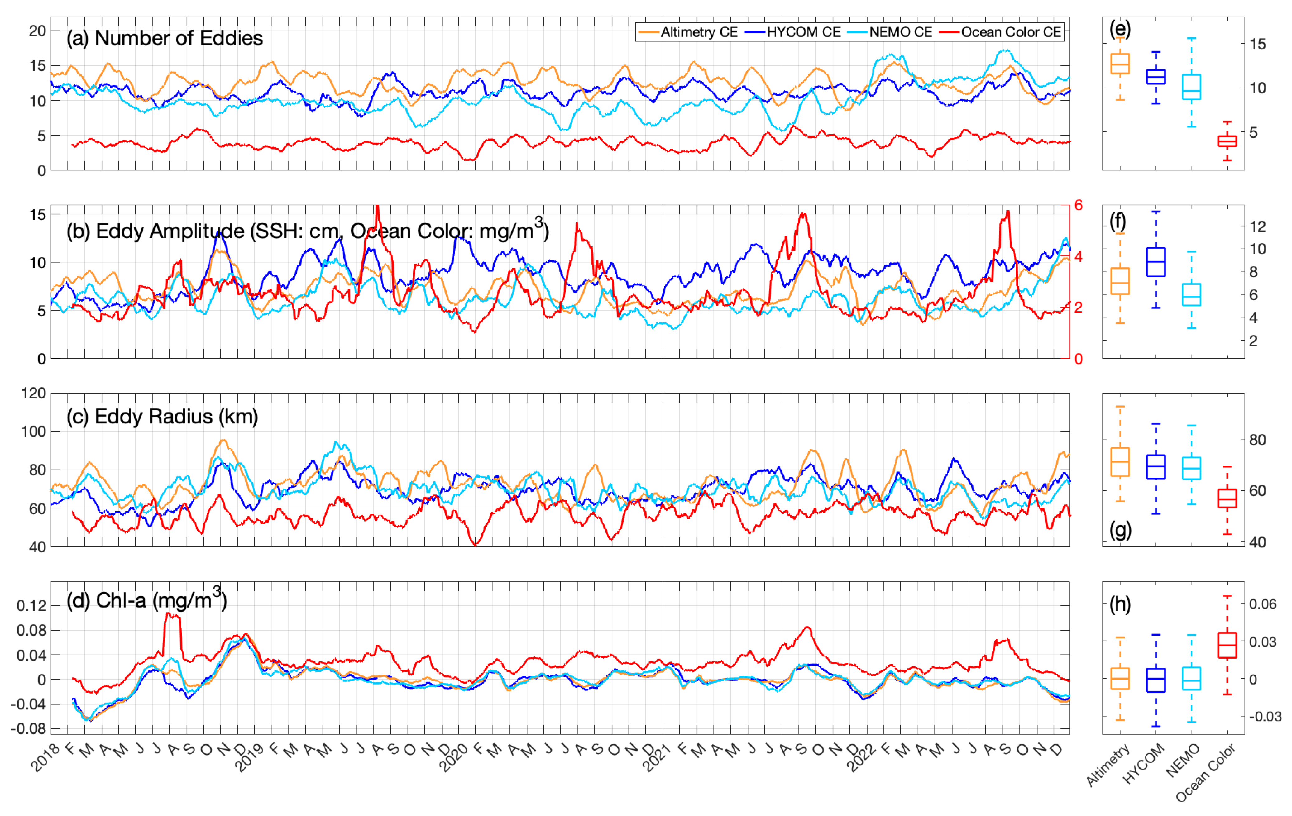
Number of daily eddies, amplitude, radius, and Chl-a concentration anomaly are plotted for cyclonic eddies (CEs) and anticyclonic eddies (AEs) from 2018 to 2022 to compare the temporal evolution of eddy characteristics identified in altimetry ADT, HYCOM SSH, and NEMO SSH (Figure 3 and Figure 4).
Ocean color Chl-a detects consistently fewer cyclonic eddies daily (4) than ADT, HYCOM SSH, or NEMO SSH (13, 11, and 10 daily eddies, respectively). Considering SSH-detected CEs, the minimum (6) and maximum (17) number of daily cyclonic eddies are identified in NEMO, with NEMO exhibiting the widest range in the number of daily eddies identified among the four datasets. Ocean color Chl-a only detected a maximum number of six cyclonic eddies in one day. Conversely, anticyclonic eddies detected in ocean color Chl-a express the same median daily number as ADT and HYCOM SSH, being 11 daily eddies. NEMO SSH exhibits fewer daily AEs at around eight. The maximum number of AEs identified on a single day is 15 eddies, identified in ocean color, and the minimum number is 4, identified in HYCOM. Ocean color-detected CEs (AEs) have a median amplitude of 2.25 mg/m3 (1.2 mg/m3). CEs (AEs) detected in ADT, HYCOM SSH, and NEMO SSH have a median amplitude of 7 cm, 9 cm, and 6 cm, respectively (6 cm, 7.5 cm, 6 cm).
The median radius of CEs detected in ocean color Chl-a is 56.5 km, which is smaller than the corresponding SSH value (about 70 km). However, SSH-detected AEs exhibit only a slightly larger radius than Chl-a AEs (Figure 3c,g). AEs detected using ocean color Chl-a have a median radius of 68.5 km, and the median radius of ADT AEs is 78.2 km, HYCOM is 74.6 km, and NEMO is 82.6 km.
A positive Chl-a anomaly is expected from CEs due to upwelling associated with cyclonic rotation, which brings nutrient-rich waters from the subsurface to the surface. Instead, the SSH-detected CE Chl-a anomaly is not significant, exhibiting a slightly negative median anomaly. This is most likely because the local Chl-a maximum from upwelled waters is masked by surrounding oligotrophic waters. Ocean color Chl-a-detected CEs exhibit a positive median Chl-a anomaly (0.108 mg/m3). The Chl-a CE anomaly is stronger than SSH CEs due to the nature of the algorithm; by definition, CEs are identified in local Chl-a maximum.
Anticyclonic rotation produces downwelling vertical motions, so a negative Chl-a anomaly signature is expected. Again, SSH-detected AEs exhibit no significant anomaly, with median values trending negative at a larger magnitude than SSH-detected CEs due to downwelling processes and surrounding nutrient-deficient waters. Ocean color Chl-a detected CEs are characterized by a larger negative anomaly on account of the algorithmic definition of AEs being local Chl-a minimum in ocean color data. Because the negative Chl-a anomaly signature of AEs is more significant in ocean-color data than CEs, the daily number of AEs identified in ocean-color Chl-a data is comparable to SSH-detected AEs.
One of the reasons for the lack of relationship between Chl-a-detected and SSH-detected AEs and CEs is due to the fact that horizontal advection is significant in the GoM and predominates the surface chlorophyll signal over variability due to vertical processes associated with geostrophically balanced eddies [27]. Large currents (>1 m/s) on the periphery of eddies in the GoM attract surrounding waters [46], which can be either oligotrophic or rich in nutrients, depending on their location. Thus, except for the LC and the LCE, which exhibit a clear signal of negative Chl-a anomaly, other eddies’ Chl-a concentration will largely be determined by the properties of the surrounding waters.
NEMO identified fewer eddies than altimetry and HYCOM from 2018 to 2021 but improved in 2022. This may be the consequence of NEMO output not representing mesoscale features well in SSH simulations in the GoM region from 2018 to 2021. The algorithm appears to sometimes identify fewer eddy features with large radii instead of many eddies with smaller radii. The year 2022 is one of the more recent simulations, so NEMO developers may have improved the representation of mesoscale eddies in SSH output.
Spikes in amplitude most likely occur when the algorithm merges multiple smaller eddies into one larger eddy. The time series plots the median value smoothed with a 30-day moving average; therefore, the amplitude or radius spikes when these merging events occur.
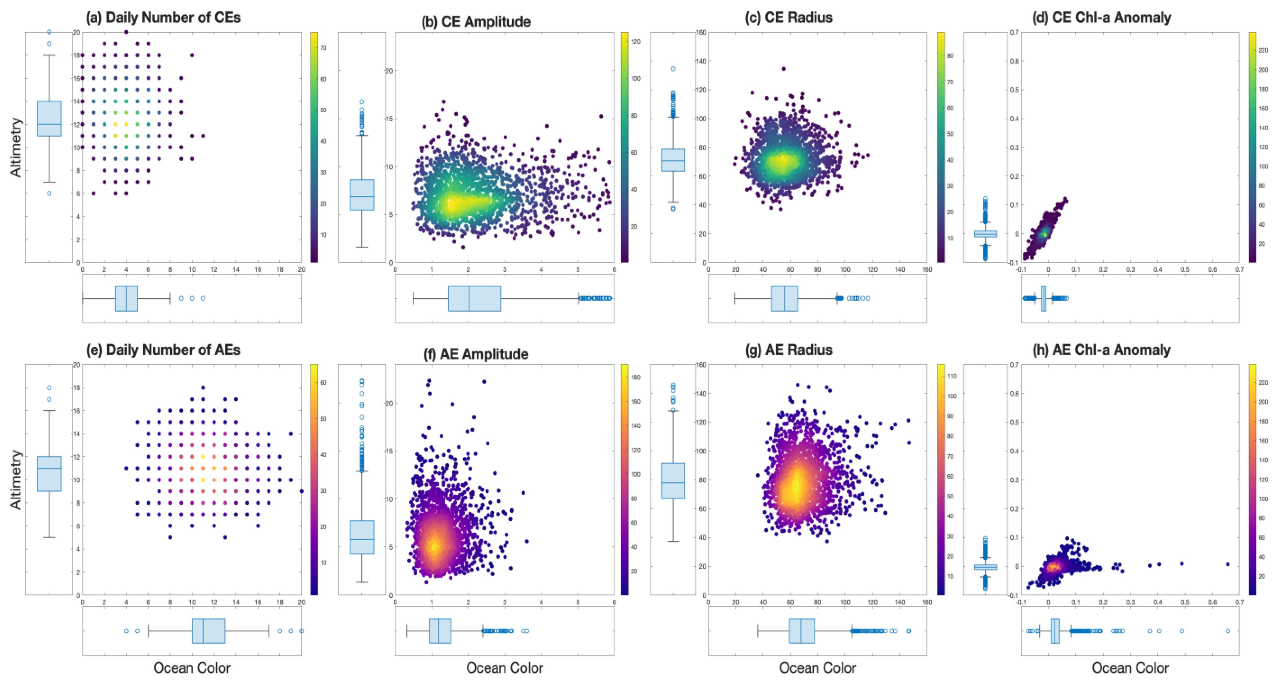
A comparison of the distribution of eddy characteristics (Figure 5) between eddies identified in altimetry and eddies identified in Chl-a notes a stark difference in results between the two approaches. The only clear 1:1 relationship is that of Chl-a anomalies in cyclonic eddies (Figure 5d). Altimetry identifies significantly more cyclonic eddies (with a median value of 12 versus 4), while ocean color identifies about the same number of anticyclonic eddies (median value of 11). While the median radius was about the same for both products, the scatterplots of daily radii (Figure 5c,h) show low to no correlation. Chlorophyll-a anomalies in cyclonic eddies align well, while Chl-a anomalies skew towards higher values in those identified by applying the eddy-tracking algorithm directly to ocean color.

3.3. Loop Current Eddy Identification Using Satellite-Derived Ocean Color Chlorophyll-a

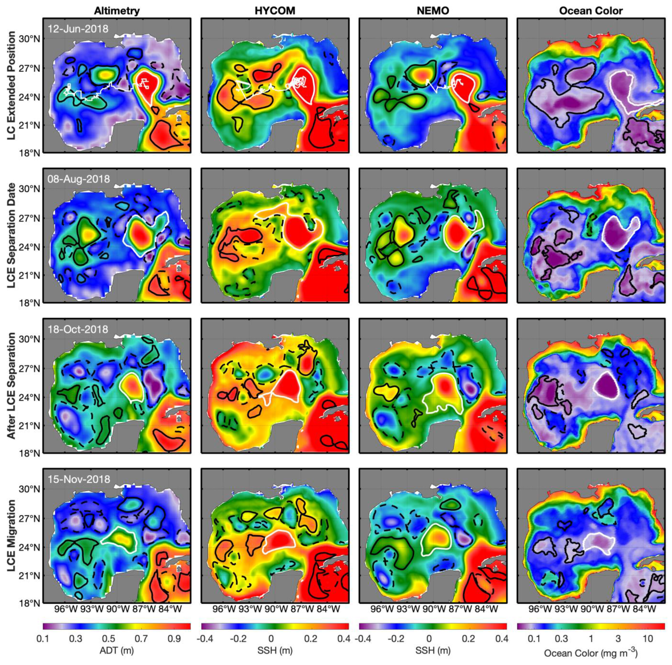
In 2018, the LCE experienced a clear shedding event, Revelle, which had been entirely pinched off in all four products by 8 August (Figure 6). The LCE’s westward propagation is the longest in altimetry and HYCOM, while the NEMO trajectory only propagates to about 90 W (white lines on top row). The Chl-a contour performs relatively well during the actual shedding event but is slightly too large prior (extending too far southward) and slightly too small after (shrinking likely due to the basin-scale wintertime of Chl-a increase eroding the strong horizontal gradients) shedding when compared to the SSH contours. Throughout the rest of the GoM, the Chl-a approach heavily favors large contours, missing smaller mesoscale or splitting events. The Chl-a approach also detects a Loop Current Frontal Eddy (LCFE) on the right flank of the LC’s neck, which is also detected in the altimetry ADT and SSH from both numerical models. LCFEs are cold-core, cyclonic eddies formed through barotropic and baroclinic instability of the LC [4,47,48,49,50]. When these eddies amplify, they strengthen the LC front and enhance the upward motion of isopycnals in the center of the eddy, subsequently increasing the vertical transport of deeper water to the upper ocean [27,46]. The high values of chlorophyll on the right flank of the LC’s neck on the ocean color map (Figure 6; 18 October 2018) show well how these frontal eddies can locally increase the concentration of nutrients through isopycnal tilting due to geostrophic adjustment.
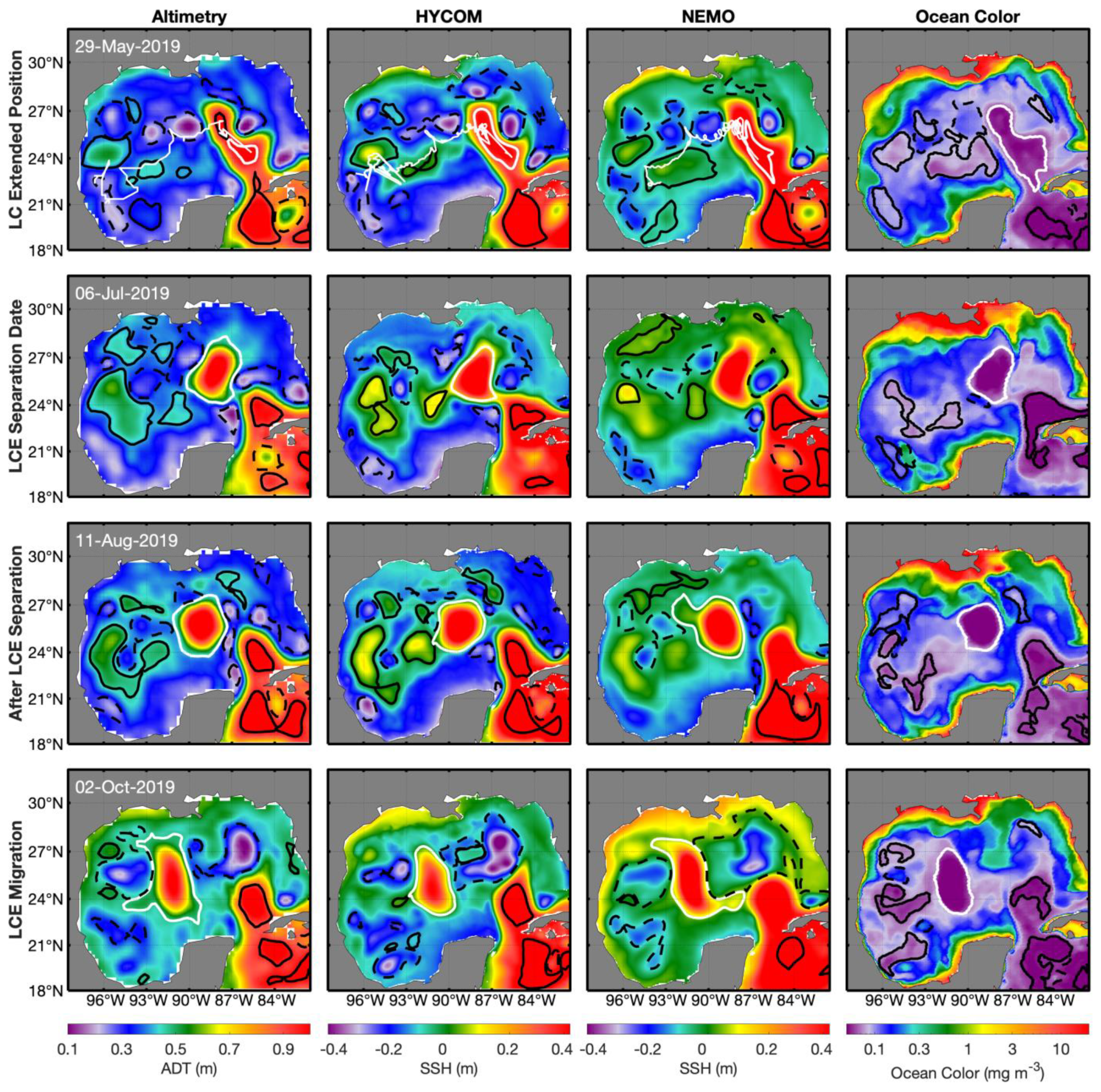
Figure 7 compares the eddy tracking results of a 2019 LCE separation event of the four datasets. The LCE named Sverdrup shed from the LC on 6 July 2019, migrating west into the GoM. Of the eddies detected in Chl-a, anticyclonic features were predominantly identified, with the LCE maintaining the strongest consistent signature over the entire eddy field. This is most likely due to the strong downwelling associated with its anticyclonic rotation, as well as the oligotrophic waters entrained in the LCE from the Caribbean Sea. CEs are mostly identified along the coast where Chl-a concentrations are highest.
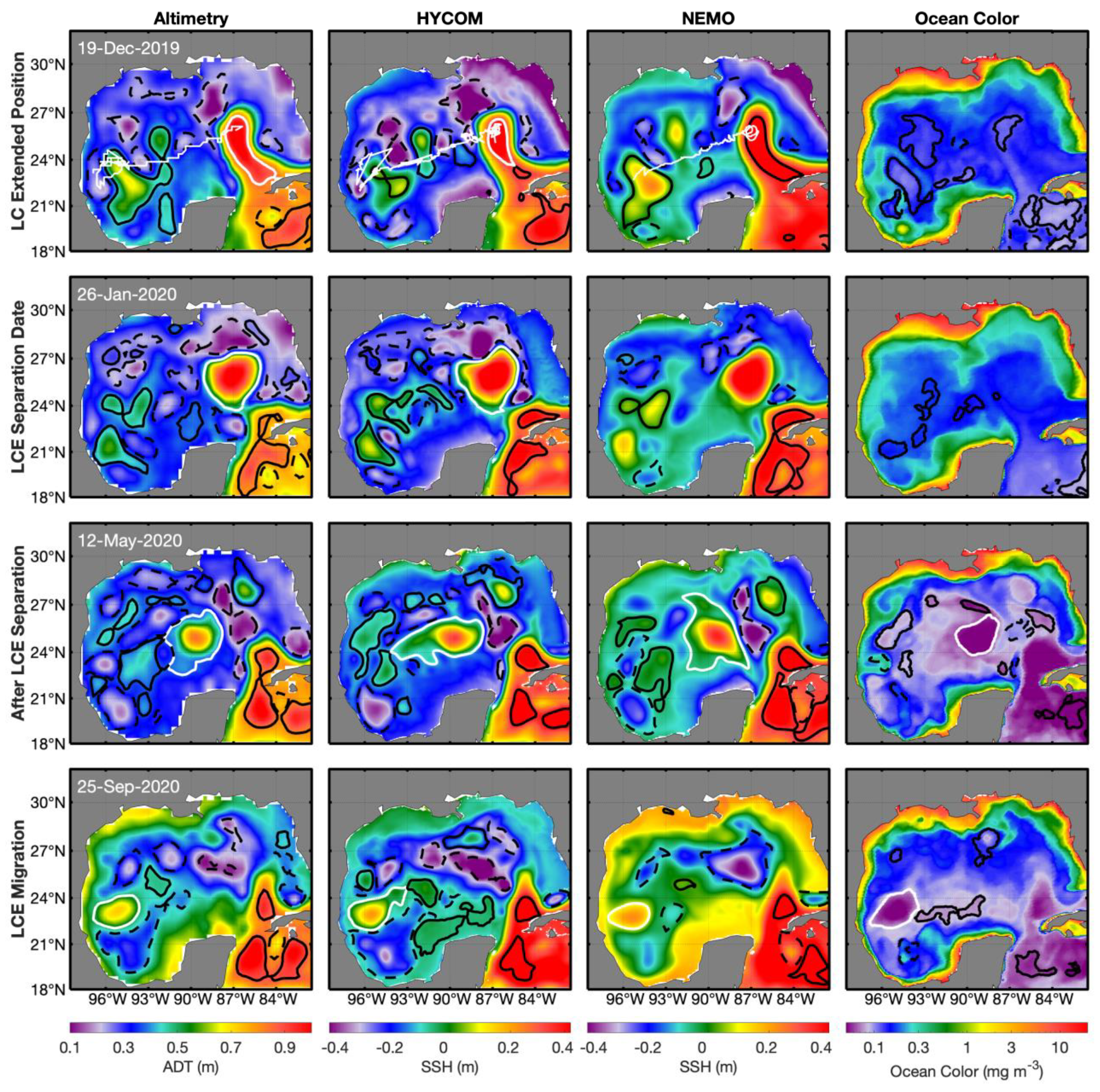
Other LCE-shedding events were less well-identified (Figure 8). LCE Thor is tracked throughout its entirety in altimetry, and HYCOM is tracked before and after separation in NEMO (but not on the separation date itself) and only after separation in ocean color. In December and January 2019, the basin-wide Chl-a gradient was low, and the LCE signal was undetectable.
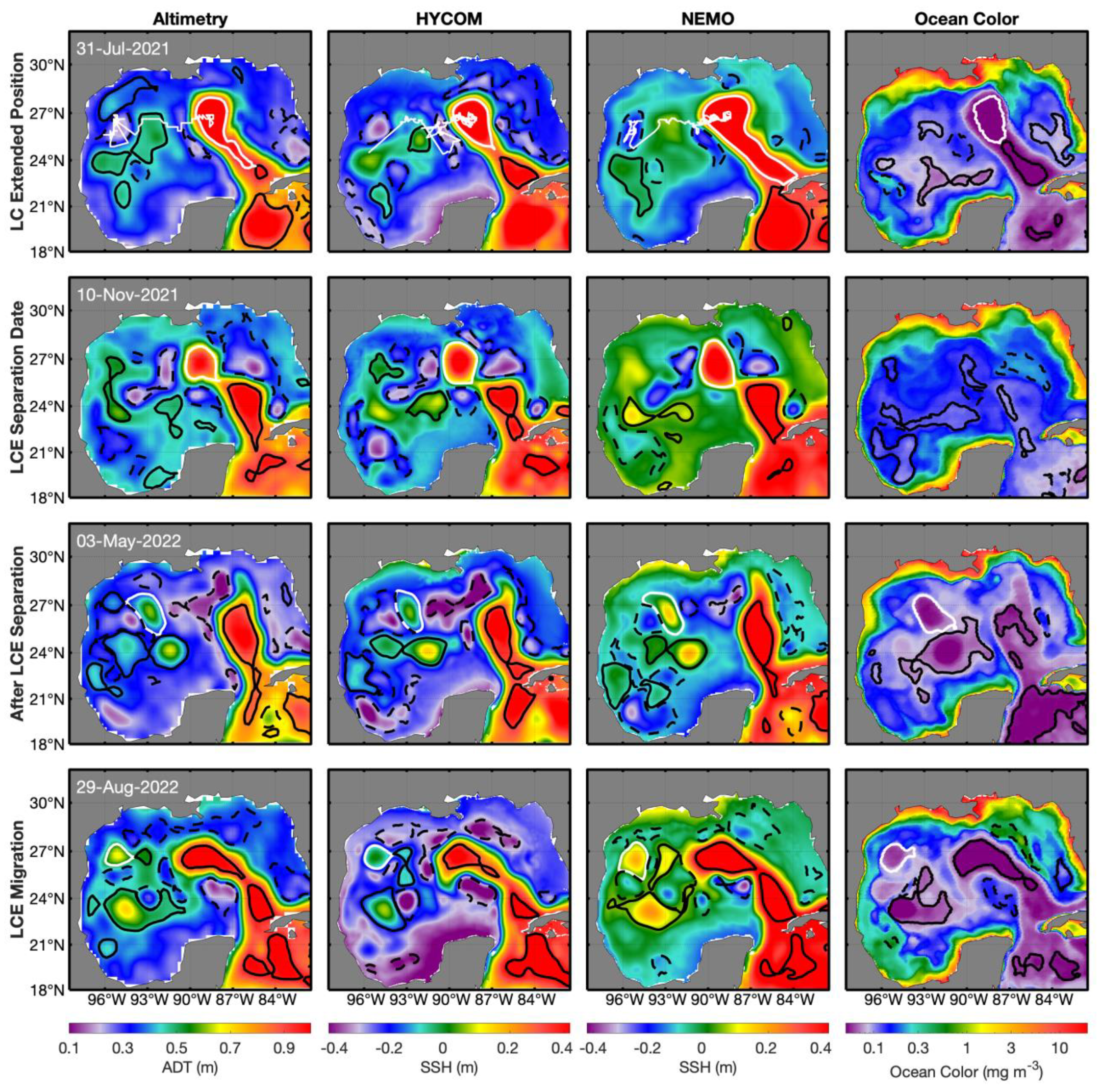
For LCE Wilde (Figure 9), all SSH products correctly identified Wilde’s edge. The Chl-a product identified Wilde on all dates except for its separation date. Prior to separation, when the LC was in a significantly extended condition almost to the coast of Louisiana, atmospheric conditions paved the way for Hurricane Ida. Hurricane Ida (Category 4, 26 August–5 September 2021) dramatically impacted the surface Chlorophyll-a concentrations in the GoM and is the likely driver of the Chl-a field seen on 10 November (Figure 9).
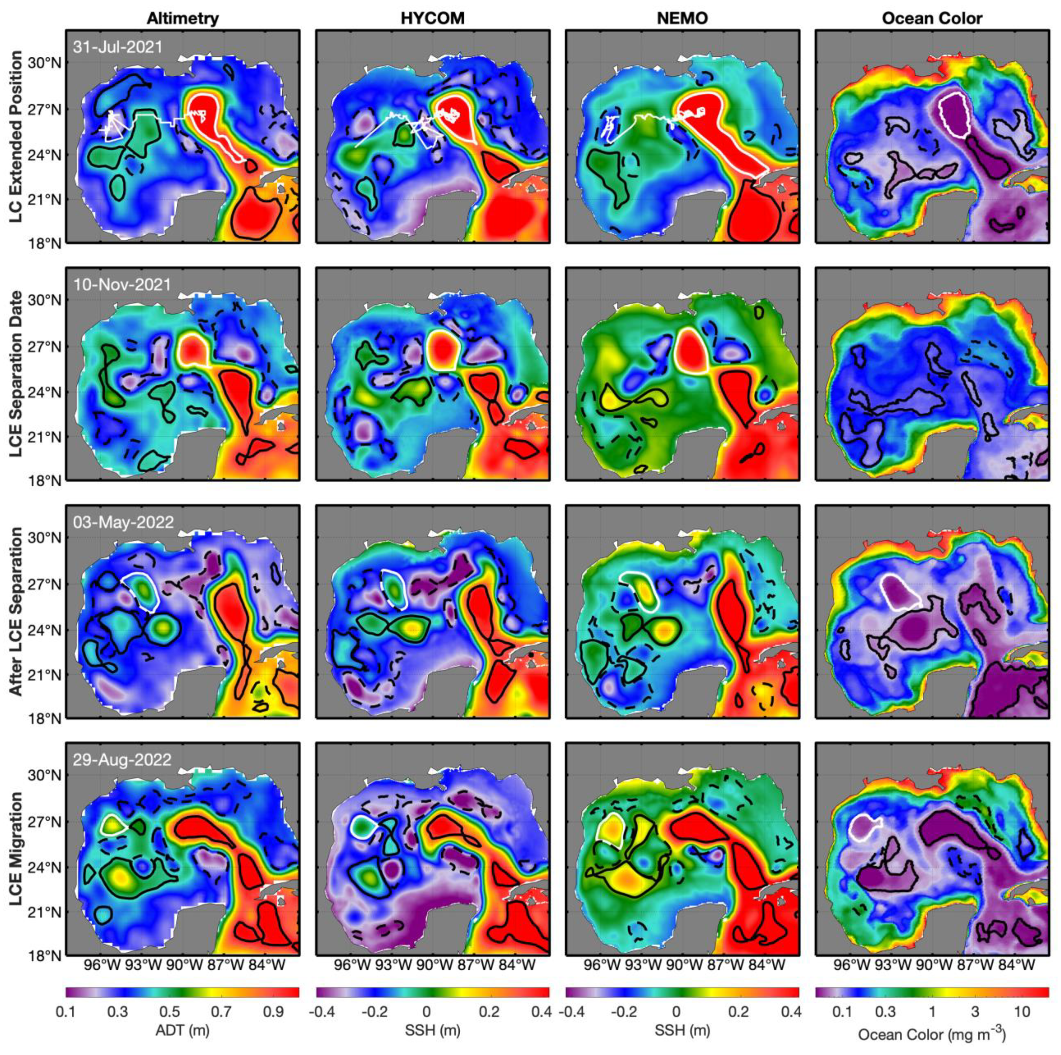
LCE Wilde II (Figure 10) was identified in ocean color during the LC extension period with a two-AE structure like that in HYCOM (likely indicating a split), while that in CMEMS and NEMO are still elongated along the LC. The three SSH products are in agreement during the separation date, where the signal in ocean color is weak due to the weakened horizontal basin-wide gradient. All four products agree during separation and migration (Figure 10). For LCE X (Figure 11), the LCE is identified during all stages, albeit with a smaller radius, except on 28 September, where it is very similar in appearance to the LCE identified in altimetry.
The eddy-tracking algorithm does not always detect the LCE well. Table 1 displays the performance of Chl-a data in identifying the LCE compared to altimetry identification. The results are divided by season to convey the effects of seasonal changes on the horizontal Chl-a gradient. Winter is not included in the analysis because the LCE Chl-a signature is not present in the uniform gradient, and there is no data from the spring of 2022 because there was no LCE shedding event present until summertime. In 2018, the LCE was identified in Chl-a data on 16.30% of the days it was identified in altimetry data in the spring (MAM), 81.52% in the summer (JJA), and 93.41% in the fall (SON). The LC remained in its extended phase until early August, so the lower values exhibited in spring and summer can be partly attributed to the algorithm trying to identify an eddy before the eddy breaks away from the LC. Spring percentage is lowest because the horizontal Chl-a gradient is not well defined until May, so the algorithm cannot identify a cohesive anticyclonic feature.

4. Discussion

Chlorophyll-a is highly sensitive to nutrient availability. The upper-ocean GoM, mostly composed of Gulf Common Water, is relatively oligotrophic, receiving nutrients from riverine outflow [44], mixed layer depth variations [14], modulated mesoscale activity caused by the LCE’s activity [24,51,52], and circulation features [53]. However, the upper portion of the LC, composed of North Atlantic Subtropical Underwater, water mass characteristic of the Caribbean, is even more oligotrophic than the Gulf water (e.g., [12]). Consequently, a relatively strong chlorophyll gradient is present in the LC front, separating LC water from Gulf water (Figure 1 and Figure 2), which is in agreement with previous studies [12,27]. Furthermore, LCEs are Lagrangian coherent vortices, and because of that, they conserve the water mass properties as they translate across the Gulf of Mexico [26] and can also be visually identified in ocean color maps. In this work, we test if the signature is strong enough to be tracked via a closed-contour eddy-tracking algorithm. Six shedding events were studied. For these six events, the Chl-a -based eddy-tracking approach only performed well in summer (identifying the LCE 80% of the time) and fall (77%). In winter, local primary production in LCEs is larger than the average basin-wide rate, thus offsetting its otherwise negative Chl-a anomaly and making it difficult to detect algorithmically [28].
In the GoM, surface Chl-a’s highest concentrations occur during winter between December and March, and the lowest values occur in summer between July and September. The large wintertime biomass increase is caused by the mixed layer response to winter convective mixing that lifts deep, nutrient-rich waters [28]. The observed mixed layers are deeper in AEs than CEs [20,21], and vertical nutrient fluxes in the euphotic zone are potentially enhanced in AEs during wintertime due to convection. Seasonal and interannual Chl-a variability in the GoM is mainly affected by the variability of atmospheric fluxes and mesoscale dynamics caused by the LCEs, as described in [54]. The winter deepening of the mixed layer, nutrient injection by mixing, and major river discharge from the Mississippi River also play a major role in the seasonal variation of Chl-a [55,56,57]. In this study, we showed that Chl-a is also useful for tracking the Caribbean water extension into the GoM. The physical processes that help the distribution and extension of the Chl-a from Caribbean waters into the GoM depend on estuarine fluxes, nutrients with depth, wind stress, thermal stratification, and eddy advection.

5. Conclusions

This work explored the possibility of utilizing ocean-color Chl-a data to identify LCEs, verified via traditional eddy tracking along surface topography fields (ADT from altimetry and SSH from HYCOM and NEMO). As the LC intrudes into the central GoM, it advects warmer, saltier, and lower Chl-a-containing waters compared to the Gulf waters. When the instability of the main LC results in an LCE shedding event, the resulting Lagrangian-coherent LCE retains its anomalous water mass characteristics throughout its lifespan. However, the background Chl-a field and its gradients are sensitive to air–sea interactions induced by seasonal variability (as well as synoptic events), resulting in a notable difference in Chl-a LCE identification during wintertime and summertime. Local nutrient inputs due to winter mixing raise the local LCE Chl-a such that the negative Chl-a anomalies, present in the summer in the LC and LCEs, are masked in the wintertime.
When applied to the full GoM, the median number and radius of anticyclonic eddies detected in ocean color were similar to that of the surface topography products and lower for cyclonic eddies. The most similar parameter relationship between ocean color-detected eddies and that of altimetry is that of Chl-a anomalies in cyclonic eddies. Chlorophyll-a anomalies in cyclonic eddies align well, while Chl-a anomalies skew towards higher values in those identified by applying the eddy-tracking algorithm directly to ocean color.
Six LCE shedding events were compared from 2018 to 2022 (Revelle, Sverdrup, Thor, Wilde, Wilde II, X) and were analyzed during their extension, separation, post-separation, and migration periods. Some were well-characterized by the Chl-a eddy-tracking methodology throughout their full lifespan (Revelle, Sverdrup), though others were only identified after shedding (Thor, Wilde) due to a low basin-wide Chlorophyll-a gradient. LCE identification via application of a tracking algorithm to ocean color data was significantly more successful in summer (80%) and fall (77%) than spring (30%). In this study, we used NOAA DINEOF3 Chl-a gap-filled data. In future work, we hope to use the recently launched Plankton, Aerosol, Cloud, Ocean Ecosystem (PACE) mission, which is a pathfinder mission using a hyperspectral imager, Ocean Color Instrument (OCI) Chl-a data, to better understand the LC eddies, frontal eddies, and mesoscale and sub-mesoscale dynamics in the GoM. PACE’s swath width is large enough to cover the full GoM and is particularly useful in cloud-free conditions. Its unprecedented spectral coverage global ocean color measurements can be merged with other flying ocean color sensors (VIIRS, MODIS, OLCI) to develop more advanced merged products and detect both mesoscale and submesoscale features. Additionally, as Agulhas Current eddies form under similar processes via pinching off the Agulhas Current with a westward propagation, the Chl-a approach could also be used in this region. It is expected that similar results may be achieved in regions of the world with similar or greater Chl-a gradients. Future studies would benefit from following this method to remap the higher-resolution Chl-a product to the same resolution as that of the surface topography field (in this case, 0.25°).

Author Contributions

Conceptualization, B.S.; methodology, C.B.T. and B.S.; software, C.B.T.; validation, B.S. and C.B.T.; formal analysis, C.B.T. and B.S.; investigation, B.S. and C.B.T.; resources, B.S.; data curation, B.S., writing, C.B.T., B.S, L.H. and O.Z.-R.; visualization, C.B.T. and B.S.; supervision, B.S; funding acquisition, B.S. All authors have read and agreed to the published version of the manuscript.

Funding

The research reported in this manuscript was supported by the Gulf Research Program of the National Academies of Sciences, Engineering, and Medicine under award number 2000013149. The content is solely the responsibility of the authors and does not necessarily represent the official views of the Gulf Research Program or the National Academies of Sciences, Engineering, and Medicine. This has NRL contribution number JA-7320-24-6440. Approved for public release, distribution is unlimited. The authors acknowledge no conflicts of interest, financial or otherwise, with respect to the results of this study.

Data Availability Statement

The ocean color Chlorophyll-a data used in this study was downloaded from NOAA Coastwatch from https://coastwatch.noaa.gov/cwn/products/noaa-msl12-multi-sensor-dineof-global-gap-filled-products-chlorophyll-diffuse-attenuation.html (accessed on 5 March 2024). Altimetry Dynamic Topography (ADT) data used in this research is courtesy of the Copernicus Marine Environmental Monitoring Service (CMEMS; marine.copernicus.eu and data downloaded from https://data.marine.copernicus.eu/product/SEALEVEL_GLO_PHY_L4_MY_008_047/description (accessed on 17 July 2023). HYCOM Model simulations were downloaded from https://www.hycom.org/data/gomb0pt04/gom-reanalysis (accessed on 17 April 2023). CMEMS also provides the NEMO model simulations used in this research https://www.copernicus.eu/en/access-data/copernicus-services-catalogue/global-ocean-physics-reanalysis (accessed on 13 January 2023). The WHO provides the Gulf of Mexico Loop current eddies information https://www.horizonmarine.com/loop-current-eddies (accessed on 30 April 2024).

Acknowledgments

We thank Autumn Toms for her help in this project. We are thankful for the helpful comments of the four anonymous reviewers, which improved the quality of this paper.

Conflicts of Interest

The authors declare no conflicts of interest. The funders had no role in the design of the study, in the collection, analyses, or interpretation of data, in the writing of the manuscript, or in the decision to publish the results.

References

  1. Zhang, Y.; Hu, C. Ocean temperature and color frontal zones in the Gulf of Mexico: Where, when, and why. J. Geophys. Res. Ocean. 2021, 126, e2021JC017544. [Google Scholar] [CrossRef]
  2. Pichevin, T.; Nof, D. The momentum imbalance paradox. Tellus A 1997, 49, 298–319. [Google Scholar] [CrossRef]
  3. Lee, H.-C.; Mellor, G.L. Numerical simulation of the Gulf Stream System: The Loop Current and the deep circulation. J. Goephys. Res. Ocean. 2003, 108, 25-1–25-16. [Google Scholar] [CrossRef]
  4. Donohue, K.A.; Watts, D.R.; Hamilton, P.; Leben, R.; Kennelly, M. Loop Current eddy formation and baroclinic instability. Dyn. Atms. Ocean. 2016, 76, 195–216. [Google Scholar] [CrossRef]
  5. Hall, C.A.; Leben, R.R. Observational evidence of seasonality in the timing of loop current eddy separation. Dyn. Atm. Ocean. 2016, 76, 240–267. [Google Scholar] [CrossRef]
  6. Alvera-Azcárate, A.; Barth, A.; Weisberg, R.H. The Surface Circulation of the Caribbean Sea and the Gulf of Mexico as Inferred from Satellite Altimetry. J. Phys. Oceanogr. 2009, 39, 640–657. [Google Scholar] [CrossRef]
  7. Berger, T.J.; Hamilton, P.; Singer, J.J.; Waddell, E.; Churchill, J.H.; Leben, R.R.; Lee, T.N.; Sturges, W. Desoto Canyon Eddy Intrusion, Final Report, Volume I: Executive Summary and Volume II: Technical Report; Minerals Management Service. 3p. Obligation No.: 1435-01-96-CT-30825. Report No.: OCS Study MMS 2000-079 & 2000-080; US Department of the Interior: New Orleans, LA, USA, 2000. Available online: https://espis.boem.gov/Technical%20Summaries/3187.pdf (accessed on 16 June 2024).
  8. Candela, J.; Ochoa, J.; Sheinbaum, J.; López, M.; Pérez-Brunius, P.; Tenreiro, M.; Pallas-Sanz, E.; Athie, G.; Arriaz-Olivero, L. The Flow through the Gulf of Mexico. J. Phys. Oceanogr. 2019, 49, 1381–1401. [Google Scholar] [CrossRef]
  9. Zhang, Z.; Wang, W.; Qiu, B. Oceanic mass transport by mesoscale eddies. Science 2014, 345, 322–324. [Google Scholar] [CrossRef]
  10. Shay, L.K.; Goni, G.J.; Black, P.G. Effects of a Warm Oceanic Feature on Hurricane Opal. Mon. Wea. Rev. 2000, 128, 1366–1383. [Google Scholar] [CrossRef]
  11. Dukhovskoy, D.S.; Leben, R.R.; Chassignet, E.P.; Hall, C.A.; Morey, S.L.; Nedbor-Gross, R. Characterization of the uncertainty of loop current metrics using a multidecadal numerical simulation and altimeter observations. Deep Sea Res. Part 1 Oceanogr. Res. Pap. 2015, 100, 140–158. [Google Scholar] [CrossRef]
  12. Chassignet, E.P.; Hurlburt, H.E.; Smedstad, O.M.; Barron, C.N.; Ko, D.S.; Rhodes, R.C.; Shriver, J.F.; Wallcraft, A.J.; Arnone, R.A. Assessment of ocean prediction systems in the Gulf of Mexico using ocean color. In New Developments in the Circulation of the Gulf of Mexico; Sturges, W., Lugo-Fernadez, A., Eds.; AGU Monograph Series; American Geophysical Union: Washington, DC, USA, 2006; Volume 161, pp. 87–100. [Google Scholar]
  13. Wang, Z.; Boyer, T.; Reagan, J.; Hogan, P. Upper Oceanic Warming in the Gulf of Mexico between 1950 and 2020. J. Clim. 2023, 36, 2721–2734. [Google Scholar] [CrossRef]
  14. Muller-Karger, F.E.; Smith, J.P.; Werner, S.; Chen, R.; Roffer, M.; Liu, Y.; Muhling, B.; Lindo-Atichati, D.; Lamkin, J.; CerdeiraEstrada, S.; et al. Natural variability of surface oceanographic conditions in the offshore Gulf of Mexico. Prog. Oceanogr. 2015, 134, 54–76. [Google Scholar] [CrossRef]
  15. Li, G.; Wang, Z.; Wang, B. Multidecade trends of sea surface temperature, chlorophyll-a concentration, and ocean eddies in the Gulf of Mexico. Remote Sens. 2022, 14, 3754. [Google Scholar] [CrossRef]
  16. Sturges, W.; Evans, J.C. On the variability of the Loop Current in the Gulf of Mexico. J. Mar. Res. 1983, 41, 639–653. [Google Scholar] [CrossRef]
  17. Martin, A.P.; Richards, K.J. Mechanisms for vertical nutrient transport within a North Atlantic mesoscale eddy. Deep Sea Res. Part II Top. Stud. Oceanogr. 2001, 48, 757–773. [Google Scholar] [CrossRef]
  18. Gaube, P.; Chelton, D.B.; Strutton, P.G.; Behrenfeld, M.J. Satellite observations of chlorophyll, phytoplankton biomass, and Ekman pumping in nonlinear mesoscale eddies. J. Geophys. Res.-Ocean. 2013, 118, 6349–6370. [Google Scholar] [CrossRef]
  19. Gaube, P.; Chelton, D.B.; Samelson, R.M.; Schlax, M.G.; O’Neill, L.W. Satellite observations of mesoscale eddy-induced Ekman pumping. J. Phys. Oceanogr. 2015, 45, 104–132. [Google Scholar] [CrossRef]
  20. Rai, S.; Hecht, M.; Maltrud, M.; Aluie, H. Scale of oceanic eddy killing by wind from global satellite observations. Sci. Adv. 2021, 7, eabf4920. [Google Scholar] [CrossRef]
  21. Williams, R.G. Modification of ocean eddies by air-sea interaction. J. Geophys. Res.-Ocean. 1988, 93, 15523–15533. [Google Scholar] [CrossRef]
  22. Kouketsu, S.; Tomita, H.; Oka, E.; Hosoda, S.; Kobayashi, T.; Sato, K. The role of meso-scale eddies in mixed layer deepening and mode water formation in the western North Pacific. J. Oceanogr. 2012, 68, 63–77. [Google Scholar] [CrossRef]
  23. Mayot, N.; D’Ortenzio, F.; Taillandier, V.; Prieur, L.; de Fommervault, O.P.; Claustre, H.; Bosse, A.; Testor, P.; Conan, P. Physical and biogeochemical controls of the phytoplankton blooms in North Western Mediterranean Sea: A multiplatform aproach over a complete annual cycle (2012–2013 DEWEX experiment). J. Geophys. Res.-Ocean. 2017, 122, 9999–10019. [Google Scholar] [CrossRef]
  24. Weisberg, R.H.; Liu, Y. On the Loop Current penetration into the Gulf of Mexico. J. Geophys. Res. Ocean. 2017, 122, 9679–9694. [Google Scholar] [CrossRef]
  25. Zhang, Y.; Hu, C.; Liu, Y.; Kourafalou, V.H.; McGillicuddy, D.J., Jr.; Cannizzaro, J.P.; English, D.C.; Lembke, C. Bio-Optical, Physical, and Chemical Properties of a Loop Current Eddy in the Gulf of Mexico. J. Geophys. Res. Ocean. 2023, 128, e2022JC018726. [Google Scholar] [CrossRef]
  26. Beron-Vera, F.J.; Olascoaga, M.J.; Wang, Y.; Triñanes, J.; Pérez-Brunius, P. Enduring Lagrangian coherence of a Loop Current ring assessed using independent observations. Sci. Rep. 2018, 8, 11275. [Google Scholar] [CrossRef]
  27. Hiron, L.; Miron, P.; Shay, L.K.; Johns, W.E.; Chassignet, E.P.; Bozec, A. Lagrangian coherence and source of water of Loop Current Frontal Eddies in the Gulf of Mexico. Prog. Oceanogr. 2022, 208, 102876. [Google Scholar] [CrossRef]
  28. Damien, P.; Sheinbaum, J.; Pasqueron de Fommervault, O.; Jouanno, J.; Linacre, L.; Duteil, O. Do Loop Current eddies stimulate productivity in the Gulf of Mexico? Biogeosciences 2021, 18, 4281–4303. [Google Scholar] [CrossRef]
  29. Leben, R.R. Altimeter-derived Loop Current metrics. Circulation in the Gulf of Mexico: Observations and Models. In Geophysical Monograph Series; American Geophysical Union: Washington, DC, USA, 2005; Volume 161, pp. 181–202. [Google Scholar] [CrossRef]
  30. Liu, X.; Wang, M. Global daily gap-free ocean color products from multi-satellite measurements. Int. J. Appl. Earth Obs. Geoinf. 2022, 108, 102714. [Google Scholar] [CrossRef]
  31. Andrae, A. Comparison of Different Methods for the Detection of Mesoscale Eddy Characteristics in the Eastern Tropical North Atlantic. Ph.D. Thesis, Christian-Albrechts-Universität zu Kiel, Kiel, Germany, 2020. [Google Scholar]
  32. Le Vu, B.; Stegner, A.; Arsouze, T. Angular momentum eddy detection and tracking algorithm (AMEDA) and its application to coastal eddy formation. J. Atms. Ocean Technol. 2018, 35, 739–762. [Google Scholar] [CrossRef]
  33. Garreau, P.; Dumas, F.; Louazel, S.; Stegner, A.; Le Vu, B. High-resolution observations and tracking of a dual-core anticyclonic eddy in the Algerian Basin. J. Geophys. Res. Ocean. 2018, 123, 9320–9339. [Google Scholar] [CrossRef]
  34. Ioannou, A.; Stegner, A.; Le Vu, B.; Taupier-Letage, I.; Speich, S. Dynamical evolution of intense Ierapetra eddies on a 22 year long period. J. Geophys. Res. Ocean. 2017, 122, 9276–9298. [Google Scholar] [CrossRef]
  35. Cummings, J.A.; Smedstad, O.M. Variational data analysis for the global ocean. In Data Assimilation for Atmospheric, Oceanic and Hydrologic Applications; Park, S.K., Xu, L., Eds.; Springer: Berlin/Heidelberg, Germany, 2013; Volume 2. [Google Scholar] [CrossRef]
  36. Helber, R.W.; Townsend, T.L.; Barron, C.N.; Dastugue, J.M.; Carnes, M.R. Validation Test Report for the Improved Synthetic Ocean Profile (ISOP) System, Part I: Synthetic Profile Methods and Algorithm; Naval Research Laboratory Report; NRL: Washington, DC, USA, 2013. [Google Scholar]
  37. Trott, C.B.; Subrahmanyam, B.; Chaigneau, A.; Delcroix, T. Eddy Tracking in the Northwestern Indian Ocean during Southwest Monsoon Regimes. Geophys. Res. Lett. 2018, 45, 6594–6603. [Google Scholar] [CrossRef]
  38. Trott, C.B.; Subrahmanyam, B.; Chaigneau, A.; Roman-Stork, H.L. Eddy-induced Temperature and Salinity Variability in the Arabian Sea. Geophys. Res. Lett. 2019, 46, 2734–2742. [Google Scholar] [CrossRef]
  39. Brokaw, R.J.; Subrahmanyam, B.; Trott, C.B.; Chaigneau, A. Eddy Surface Characteristics and Vertical Structure in the Gulf of Mexico from Satellite Observations and Model Simulations. J. Geophys. Res. 2020, 125, e2019JC015538. [Google Scholar] [CrossRef]
  40. Pegliasco, C.; Chaigneau, A.; Morrow, R. Main eddy vertical structures observed in the four major Eastern Boundary Upwelling Systems. J. Geophys. Res. Ocean. 2015, 120, 6008–6033. [Google Scholar] [CrossRef]
  41. Chelton, D.B.; Schlax, M.G.; Samelson, R.M. Global observations of nonlinear mesoscale eddies. Prog. Oceang. 2011, 91, 167–216. [Google Scholar] [CrossRef]
  42. Souza, J.M.A.C.; de Boyer Montégut, C.; Le Traon, P.Y. Comparison between three implementations of automatic identification algorithms for the quantification and characterization of mesoscale eddies in the South Atlantic Ocean. Ocean Sci. 2011, 7, 317–334. [Google Scholar] [CrossRef]
  43. Yi, J.; Du, Y.; He, Z.; Zhou, C. Enhancing the accuracy of automatic eddy detection and the capability of recognizing the multi-core structures from maps of sea level anomaly. Ocean Sci. 2014, 10, 39. [Google Scholar] [CrossRef]
  44. Trott, C.B.; Metzger, E.J.; Yu, Z. Investigating mesoscale eddy characteristics in the Luzon Strait region using altimetry. Ocean Dyn. 2021, 71, 679–698. [Google Scholar] [CrossRef]
  45. Brokaw, R.J.; Subrahmanyam, B.; Morey, S.L. Loop Current and Eddy-Driven Salinity Variability in the Gulf of Mexico. Geophys. Res. Lett. 2019, 46, 5978–5986. [Google Scholar] [CrossRef]
  46. Hiron, L.; Nolan, D.S.; Shay, L.K. Study of Ageostrophy during Strong, Nonlinear Eddy-Front Interaction in the Gulf of Mexico. J. Phys. Oceanogr. 2021, 51, 745–755. [Google Scholar] [CrossRef]
  47. Chérubin, L.M.; Morel, Y.; Chassignet, E.P. Loop Current ring shedding: The formation of cyclones and the effect of topography. J. Phys. Oceanogr. 2006, 36, 569–591. [Google Scholar] [CrossRef]
  48. Jouanno, J.; Ochoa, J.Z.; Pallás-Sanz, E.; Sheinbaum, J.; Andrade-Canto, F.; Candela, J.; Molines, J.-M. Loop current frontal eddies: Formation along the Campeche Bank and impact of coastally trapped waves. J. Phys. Oceanogr. 2016, 46, 3339–3363. [Google Scholar] [CrossRef]
  49. Garcia-Jove, M.; Sheinbaum, J.; Jouanno, J. Sensitivity of Loop Current metrics and eddy detachments to different model configurations: The impact of topography and Caribbean perturbations. Atmósfera 2016, 29, 235–265. [Google Scholar] [CrossRef]
  50. Yang, Y.; Weisberg, R.H.; Liu, Y.; Liang, X.S. Instabilities and multiscale interactions underlying the Loop Current eddy shedding in the Gulf of Mexico. J. Phys. Oceanogr. 2020, 50, 1289–1317. [Google Scholar] [CrossRef]
  51. McGillicuddy, D.J. Formation of Intrathermocline Lenses by Eddy–Wind Interaction. J. Phys. Oceanogr. 2015, 45, 606–612. [Google Scholar] [CrossRef]
  52. Biggs, D.C.; Ressler, P.H. Distribution and Abundance of Phytoplankton, Zooplankton, Ichthyoplankton, and Micronekton, in the Deepwater Gulf of Mexico. Gulf Mex. Sci. 2001, 19, 2. [Google Scholar] [CrossRef]
  53. Sturges, W.; Leben, R. Frequency of ring separation from the Loop Current in the Gulf of Mexico: A revised estimate. J. Phys. Oceanogr. 2000, 30, 1814–1819. [Google Scholar] [CrossRef]
  54. Damien, P.; de Fommervault, P.O.; Sheinbaum, J.; Jouanno, J.; Camacho-Ibar, V.F.; Duteil, O. Partitioning of the Open Waters of the Gulf of Mexico Based on the Seasonal and Interannual Variability of Chlorophyll Concentration. J. Geophys. Res.-Ocean. 2018, 123, 2592–2614. [Google Scholar] [CrossRef]
  55. Lohrenz, S.E.; Fahnenstiel, G.L.; Redalje, D.G.; Lang, G.A.; Chen, X.; Dagg, M.J. Variations in primary production of northern Gulf of Mexico continental shelf waters linked to nutrient inputs from the Mississippi River Mar. Ecol. Prog. Ser. 1997, 155, 45–54. [Google Scholar] [CrossRef]
  56. Cullen, J.J.; Franks, P.J.; Karl, D.M.; Longhurst, A. Physical influences on marine ecosystem dynamics. Sea 2002, 12, 297–336. [Google Scholar]
  57. Jolliff, J.K.; Kindle, J.C.; Penta, B.; Helber, R.; Lee, Z.; Shulman, I.; Arnone, R.; Rowley, C.D. On the relationship between satellite-estimated bio-optical and thermal properties in the Gulf of Mexico. J. Geophys. Res. 2008, 113, G01024. [Google Scholar] [CrossRef]
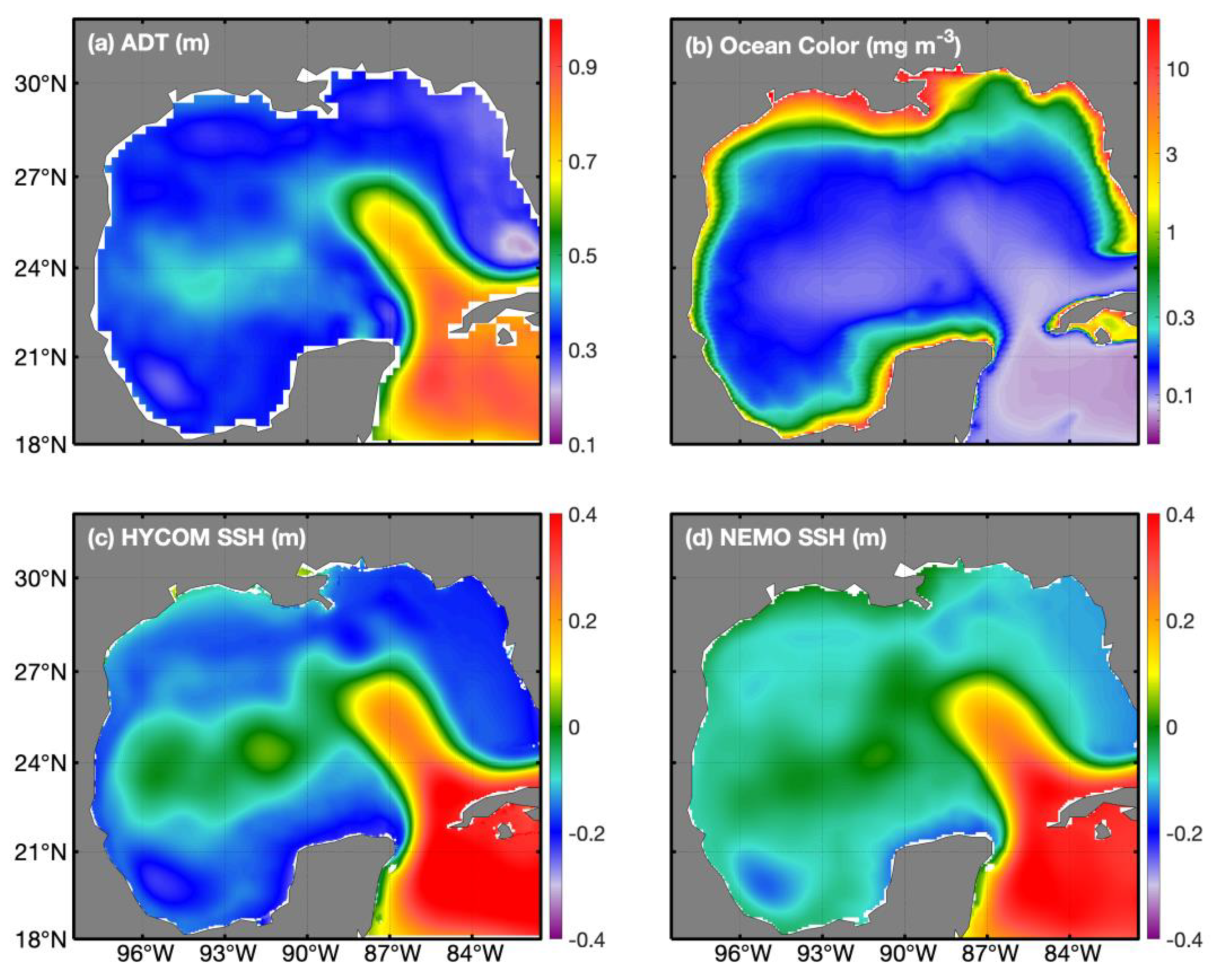
Figure 1. (a) Satellite-derived absolute dynamic topography (ADT) (m), (b) satellite-derived Chlorophyll-a (Chl-a) concentration (mg/m3); (c) HYCOM derived sea surface height (SSH) (m); and (d) NEMO derived SSH (m) for 2018–2022.
Remotesensing 16 02234 g001
Figure 2. Monthly mean satellite-derived Chlorophyll-a (Chl-a) concentration (mg/m3) and 17 cm altimetry contour value plotted representing the Loop Current position for the year 2019.
Remotesensing 16 02234 g002
Figure 3. Daily eddy characteristics (ad) from 2018 to 2022 for satellite altimetry, HYCOM GoM, and NEMO data of anticyclonic eddies and the respective boxplots (eh) showing median, upper, and lower quartiles, and minimum and maximum of these characteristics. The boxplot for ocean Color is not shown due to its different units, which would be mg/m3. Characteristics (a,e) number of eddies, (b,f) average eddy amplitude (cm), (c,g) average eddy radius (km), and (d,h) average Chl-a anomaly (mg/m3).
Remotesensing 16 02234 g003
Figure 4. Same as Figure 3 but for cyclonic eddies. (a,e) number of eddies, (b,f) average eddy amplitude (cm), (c,g) average eddy radius (km), and (d,h) average Chl-a anomaly (mg/m3).
Remotesensing 16 02234 g004
Figure 5. Daily eddy characteristics from 2018 to 2022 for satellite altimetry and ocean color of Chl-a anticyclonic and cyclonic eddies using scatterplots. Units for amplitude, radius, and Chl-a anomaly are cm, km, and mg/m3, respectively.
Remotesensing 16 02234 g005
Figure 6. Eddy tracking of 2018 LCE (Revelle) when LC is in extended position (top row), LCE separation date (second row), after LCE separation (third row), and LCE migration (bottom row). Shown in satellite altimetry (first column), HYCOM (second column), NEMO (third column), and ocean color of Chl-a data (fourth column). Eddy trajectory is plotted in the (first row).
Remotesensing 16 02234 g006
Figure 7. Eddy tracking of 2019 LCE (Sverdrup) when LC is in extended position (top row), LCE separation date (second row), after LCE separation (third row), and LCE migration (bottom row). Shown in satellite altimetry (first column), HYCOM (second column), NEMO (third column), and ocean color of Chl-a data (fourth column). Eddy trajectory is plotted in the (first row).
Remotesensing 16 02234 g007
Figure 8. Eddy tracking of 2020 LCE (Thor) when LC is in extended position (top row), LCE separation date (second row), after LCE separation (third row), and LCE migration (bottom row). Shown in satellite altimetry (first column), HYCOM (second column), NEMO (third column), and ocean color of Chl-a data (fourth column). Eddy trajectory plotted in (first row).
Remotesensing 16 02234 g008
Figure 9. Eddy tracking of 2021 LCE (Wilde) when LC is in extended position (top row), LCE separation date (second row), after LCE separation (third row), and LCE migration (bottom row). Shown in satellite altimetry (first column), HYCOM (second column), NEMO (third column), and ocean color of Chl-a (fourth column). Eddy trajectory plotted in (first row).
Remotesensing 16 02234 g009
Figure 10. Eddy tracking of 2022 LCE when LC (Wilde II) is in extended position (top row), LCE separation date (second row), after LCE separation (third row), and LCE migration (bottom row). Shown in satellite altimetry (first column), HYCOM (second column), NEMO (third column), and ocean color of Chl-a (fourth column). Eddy trajectory plotted in (first row).
Remotesensing 16 02234 g010
Figure 11. Eddy tracking of 2022 LCE (X) when LC is in extended position (top row), LCE separation date (second row), after LCE separation (third row), and LCE migration (bottom row). Shown in satellite altimetry (first column), HYCOM (second column), NEMO (third column), and ocean color of Chl-a (fourth column). Eddy trajectory plotted in (first row).
Remotesensing 16 02234 g011
Table 1. Percentage of days a LCE is detected in ocean color data out of the number of days the LCE was identified in altimetry data. The average values for all LCE events from 2018–2022 are included in the last column.
2018:
Revelle
2019: Sverdrup2020: Thor2021: Wilde2022: Wilde II2022: X2018–2022
Total
Spring (MAM)16.30%1.09%79.35%39.13%55.43%N/A30.43%
Summer (JJA)81.52%63.04%100%56.52%100%79.35%80.07%
Fall (SON)93.41%95.60%47.25%65.38%91.21%71.43%77.38%
Disclaimer/Publisher’s Note: The statements, opinions and data contained in all publications are solely those of the individual author(s) and contributor(s) and not of MDPI and/or the editor(s). MDPI and/or the editor(s) disclaim responsibility for any injury to people or property resulting from any ideas, methods, instructions or products referred to in the content.