Article

Transboundary Central African Protected Area Complexes Demonstrate Varied Effectiveness in Reducing Predicted Risk of Deforestation Attributed to Small-Scale Agriculture

by
Katie P. Bernhard
1,*,
Aurélie C. Shapiro
2,
Rémi d’Annunzio
2 and
Joël Masimo Kabuanga
3,4
1
Department of Recreation, Park and Tourism Management, Pennsylvania State University, University Park, PA 16802, USA
2
Forestry Division, Food and Agriculture Organization of the United Nations, 00153 Rome, Italy
3
Faculté des Sciences Agronomiques, Université du Bas-Uélé, Buta, Democratic Republic of the Congo
4
Institut de Recherche sur les Forêts, Université du Québec en Abitibi-Témiscamingue, Rouyn-Noranda, QC J9X 5E4, Canada
*
Author to whom correspondence should be addressed.
Remote Sens. 2024, 16(1), 204; https://doi.org/10.3390/rs16010204
Submission received: 29 August 2023 / Revised: 24 December 2023 / Accepted: 27 December 2023 / Published: 4 January 2024
(This article belongs to the Special Issue Recent Progress in Earth Observation Data for Sustainable Development)

Abstract

:
The forests of Central Africa constitute the continent’s largest continuous tract of forest, maintained in part by over 200 protected areas across six countries with varying levels of restriction and enforcement. Despite protection, these Central African forests are subject to a multitude of overlapping proximate and underlying drivers of deforestation and degradation, such as conversion to small-scale agriculture. This pilot study explored whether transboundary protected area complexes featuring mixed resource-use restriction categories are effective in reducing the predicted disturbance risk to intact forests attributed to small-scale agriculture. At two transboundary protected area complex sites in Central Africa, we used Google Earth Engine and a suite of earth observation (EO) data, including a dataset derived using a replicable, open-source methodology stemming from a regional collaboration, to predict the increased risk of deforestation and degradation of intact forests caused by small-scale agriculture. For each complex, we then statistically compared the predicted increased risk between protected and unprotected forests for a stratified random sample of 2 km sites (n = 4000). We found varied effectiveness of protected areas for reducing the predicted risk of deforestation and degradation to intact forests attributed to agriculture by both the site and category of protected areas within the complex. Our early results have implications for sustainable agriculture development, forest conservation, and protected areas management and provide a direction for future research into spatial planning. Spatial planning could optimize the configuration of protected area types within transboundary complexes to achieve both forest conservation and sustainable agricultural production outcomes.

1. Introduction

The natural ecosystems of the Congo Basin region in Central Africa are critical for regulating global climate and securing biodiversity in Africa’s largest continuous tract of forest (Figure 1) [1,2]. There are over 200 protected areas across six countries in Central Africa (Cameroon (CMR), the Central African Republic (CAR), Democratic Republic of the Congo (DRC), Republic of the Congo (COG), Gabon (GAB), and Equatorial Guinea (GNQ)), ranging from national parks and forest or wildlife reserves to hunting areas, with various degrees of resource-use restriction and enforcement. Meanwhile, Central African forests also sustain livelihoods at regional, national, and local scales [3,4,5]. Both protected and unprotected Central African forests are under threat of conversion to small- and large-scale agriculture to meet nutritional and economic needs, along with mining, forestry, and urban and rural infrastructure expansion [2,6,7,8,9,10,11]. There are unresolved debates in the literature regarding whether area-based models of varying degrees of resource-use and access restriction are appropriate in such contexts of high land and resource needs from local populations and, more broadly, whether the protected areas model is effective for biodiversity conservation [12,13,14,15,16,17,18,19,20,21].
While protected areas effectiveness—in terms of maintaining biodiversity and reducing forest and wildlife habitat loss—is often dependent on local and national contexts, such as prioritization and funding allocation to conservation [12,24] and local community needs and perceptions of conservation [25], the literature has identified several generalized factors that tend to influence effectiveness. First, the level of resource-use restriction (e.g., International Union for Conservation of Nature (IUCN) Category Ia—strict nature reserve versus Category II—national park versus Category VI—protected area with sustainable use of natural resources) influences the level of forest cover or habitat loss within a protected area [26,27,28]. The age of the protected area, agricultural suitability of soils, and proximity to international borders or highly developed areas can also influence protected area effectiveness [18,29,30,31]. Considering these factors and debates regarding protected area effectiveness in recent decades, a plurality of management approaches and models have been suggested [19,26]. For example, collaborative transboundary efforts present opportunities for the protection of ecosystems and landscapes that cross international boundaries [21,32].
As this literature continues to develop, several innovative open-source and cloud-based geospatial applications have advanced in recent years, enabling access to advanced processing capabilities for vast collections of high-resolution satellite imagery in the cloud [6,33,34,35,36,37,38,39,40,41,42]. The increased availability, accessibility, and quality of earth observation (EO) data opens doors to understanding the factors that influence protected area effectiveness through forest and land cover changes in new and under-studied contexts and creates opportunities to address challenges for ecosystems and sustainable development via spatial and land use planning [6,10,34,37,43,44].
This pilot study built on these recent efforts to understand protected area effectiveness and resource pressure on forests via EO data and cloud-based geospatial processing and analysis tools. Using a dataset derived via replicable, open-source methodology stemming from a regional collaboration [2], we deployed a random forest algorithm in Google Earth Engine and performed statistical analyses of the resulting outputs in R to explore whether under-studied transboundary protected area complexes featuring mixed resource-use restriction categories (e.g., national parks adjacent to forest reserves) are effective in reducing the predicted level of small-scale agriculture threat to intact forests. Our preliminary results suggest that effectiveness by this measure varies within and between transboundary complexes and that the spatial arrangement of resource-use restriction categories can play a role in determining the risk to intact forests.

1.1. Research Questions

The research questions and corresponding hypotheses in this pilot study were based on the literature and core theory underlying the area-based model, which suggests that effective protection reduces the risk of deforestation and degradation of intact forests [18,29]:
(1)
Are there significant differences in predicted threat to intact forests caused by deforestation-driver activities, such as small-scale agriculture expansion, between protected and unprotected transboundary forests in Central Africa (e.g., inside versus outside park boundaries)?
H1: 
Predicted risk to intact forests resulting from small-scale agriculture will be lower inside protected area boundaries.
(2)
To what extent does a mix of protection categories and resource-use restrictions in a protected area complex influence the predicted threat to intact forests?
H2: 
The magnitude of predicted risk to intact forests resulting from small-scale agriculture will vary depending on the type of protected area and/or resource-use restriction. Preliminary evidence will suggest that the spatial configuration of categories within a protected area complex influences risk magnitude.
(3)
As a pilot study, what does the initial evidence suggest for future directions of expanded analyses and research to shed further light on the effectiveness of transboundary-protected area complexes in Central Africa?
H3: 
Evidence will support future research in spatial econometrics and spatial optimization for land use planning and protected areas management.

1.2. Literature Review

This study is situated at the intersection of three literatures: drivers of deforestation and forest degradation, protected area effectiveness, and a sub-literature exploring comparative and counterfactual analyses inside and outside of protected areas. First, the drivers of deforestation literature highlights the role of small-scale agriculture as a driver of forest change in Sub-Saharan Africa (SSA). In SSA, despite substantial efforts towards protection, small-scale agriculture remains a primary proximate driver of both deforestation and degradation [6,7,8,11,20,42,45,46,47]. Other common drivers include subsistence extraction activities like fuelwood collection, infrastructure development, small-scale and industrial mining, and natural or anthropogenic fires, many of which are frequently found in combination [2,11,42,48,49].
In addition to the proximate causes of forest change in the tropics and SSA, there are underlying conditions enacted from local to global scales that influence forest and land cover change [42,45,50,51,52,53]. Conflict [30,54,55,56], political instability, and weak institutions [54,57,58] impact forest cover through inconsistent application of environmental policy or increasing pressure to extract natural resources. Environment and development economics understands the relationship between the proximate and underlying drivers as contributing to poverty-environment traps, where underlying drivers create conditions for proximate drivers that result in environmental degradation—subsequently driving a positive feedback loop, accelerating proximate drivers, and further degrading natural resources and the environment [50,59]. Alternative theories, such as the Environmental Kuznets Curve, have posited that economic development will result in increasing environmental degradation up to a threshold point, beyond which stable underlying institutional and governance conditions (in addition to shifts in economic activities and livelihoods themselves) will improve environmental conditions over time [59,60].
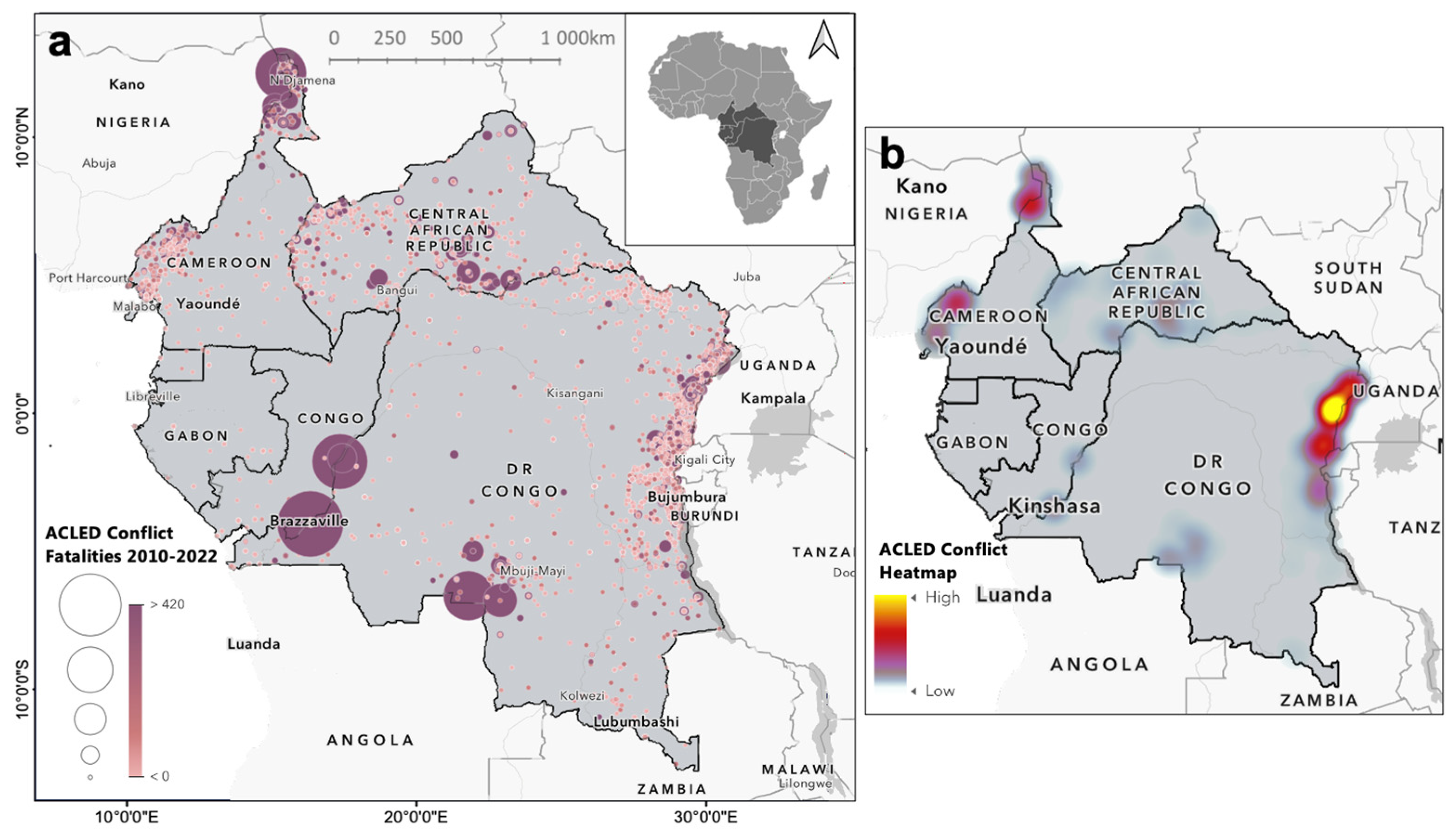
Institutional, governance, conflict, and other social, political, and economic factors that influence forest change also segue into factors that influence protected areas effectiveness [18,31,61]. Conflict, for example, can have varying influences on forest cover, in some cases increasing degradation and, in other cases, reducing degradation via internal displacement and reduced pressure on a forest system [42,43,49,55,61]. Yet conflict has resulted in enforcement challenges and de-prioritization for Central African protected areas in regions of the DRC and in conflicted areas of CMR and CAR (Figure 2) [62].
There are questions in the protected areas effectiveness literature, however, regarding the ability of protected areas to limit the proximate drivers of deforestation and degradation in addition to their adaptation to underlying conditions in local contexts [20,64]. Perceived legitimacy of protected areas by local communities has historically been a challenge for protected areas enforcement, particularly efforts that seek to limit encroachment via proximate drivers such as small-scale agriculture and subsistence activities [65]. Such legitimacy and enforcement challenges can be linked to the histories of forced eviction and displacement of local people and the destruction of livelihoods for protected area demarcation [13,65,66,67,68]. Continued subsistence and small-scale agricultural activity in African protected areas can also be viewed through the lenses of basic needs, livelihoods, food security, and sustainable livelihood approaches [69]. Striking a balance between the protection of biodiversity hotspots such as Congo Basin forests and the economic needs of local communities is also particularly important, as the literature increasingly emphasizes shifting “blame” for deforestation and degradation away from local communities in contexts where pressure on forest resources comes from multiple underlying and proximate sources not limited to local community needs [70].
That said, there is also a plurality of models that support different levels of resource use within protected areas and opportunities for dual benefit for ecosystems and economic and development needs of communities [19,26,27,71,72]. While different countries may have varying national systems to classify and prioritize protected areas based on their own objectives, national categories often align with IUCN categories. For example, as detailed by Pélissier and others [73] (p. 86), the DRC protected area system features twelve categories that can be grouped into IUCN categories. Over 25 of the DRC’s protected areas are hunting reserves, consistent with IUCN’s Category VI—protected area with sustainable use of natural resources, while the DRC’s special reserves, nature reserves, and wildlife reserves align with Category II—national park [73] (p. 86). For those protected areas that align with Category VI, there may be resource-use allowances—but determining what is a sustainable or unsustainable use may complicate the enforcement efforts in already challenging contexts like in northern DRC (see Section 2.1). An additional complication is the transboundary context, where strictness of enforcement or resource-use restriction may be uneven between countries. In these cases, collaborative transboundary protected area management presents both an opportunity and a challenge [21,32,57,74,75,76,77,78,79,80].
In efforts to quantify the potential effectiveness of protected areas and assess conservation outcomes, a growing literature has compared parameters inside and outside protected areas, often utilizing satellite imagery and increasingly using counterfactual analysis with empirical quantitative research designs that enable causal inference [81,82,83,84,85]. Comparative analyses of predicted loss inside and outside protected area boundaries shed light on factors that contribute to deforestation and forest degradation even when a forest is protected, such as studies by Buřivalová et al. [29] and Heino et al. [86]. Other factors such as forest cover outside of a protected area, agricultural suitability of the soil, age of the park, and enforcement may influence the risk to intact forests inside of a protected area [29,86].
In the present study, we used theory and evidence within this literature to frame our hypotheses, particularly research suggesting that, if effective, protected areas can reduce threats to existing intact forest, thereby reducing risk when understood as the probability of an event multiplied by the magnitude of the degradation or loss [27,29,31,72,87]. We hypothesized that the predicted risk to intact forests from small-scale agricultural conversion would be lower inside of effectively protected area boundaries than outside [29]. We contributed an additional dimension to this literature via our focus on transboundary protected areas, capturing continuous forests overlapping international boundaries. The effectiveness of transboundary protected areas for reducing forest loss, as compared to non-transboundary protected areas, has great potential but is still under-studied in the literature [32,76,78,79,80]. Further, the potential influence of spatial arrangement of protected area categories within the same transboundary protected area complex is also under-studied. There have been analyses of leakage effects from strictly protected to unprotected areas and international spillover effects [11,21,88], but few studies have explored how the configuration of protection types might influence the overall effectiveness.
Finally, we note that debates surrounding the appropriateness of the protected areas model overall have not been resolved in the literature, despite the increasing centrality of protected areas in global discussions regarding sustainable development, climate change mitigation and carbon sequestration [89], and biodiversity conservation with the 2021 adoption of the UN Convention on Biological Diversity 30 by 30 Global Biodiversity Framework to protect 30% of the world’s protected areas by 2030 [90]. Mora and Sale [13] and Eklund and Cabeza [91] argued that the protected areas model is insufficient to address the current threats to biodiversity and tropical forests. Du et al. [19], Dudley et al. [71], Hill et al. [14], Cumming [15], and Green et al. [20] suggest that recent advances and the plurality of area-based models are promising but support alternative conservation strategies for currently unprotected landscapes. However, scholars such as Galvin et al. [92] have found that even community-focused conservation models do not always achieve their social objectives at the community level.

2. Materials and Methods

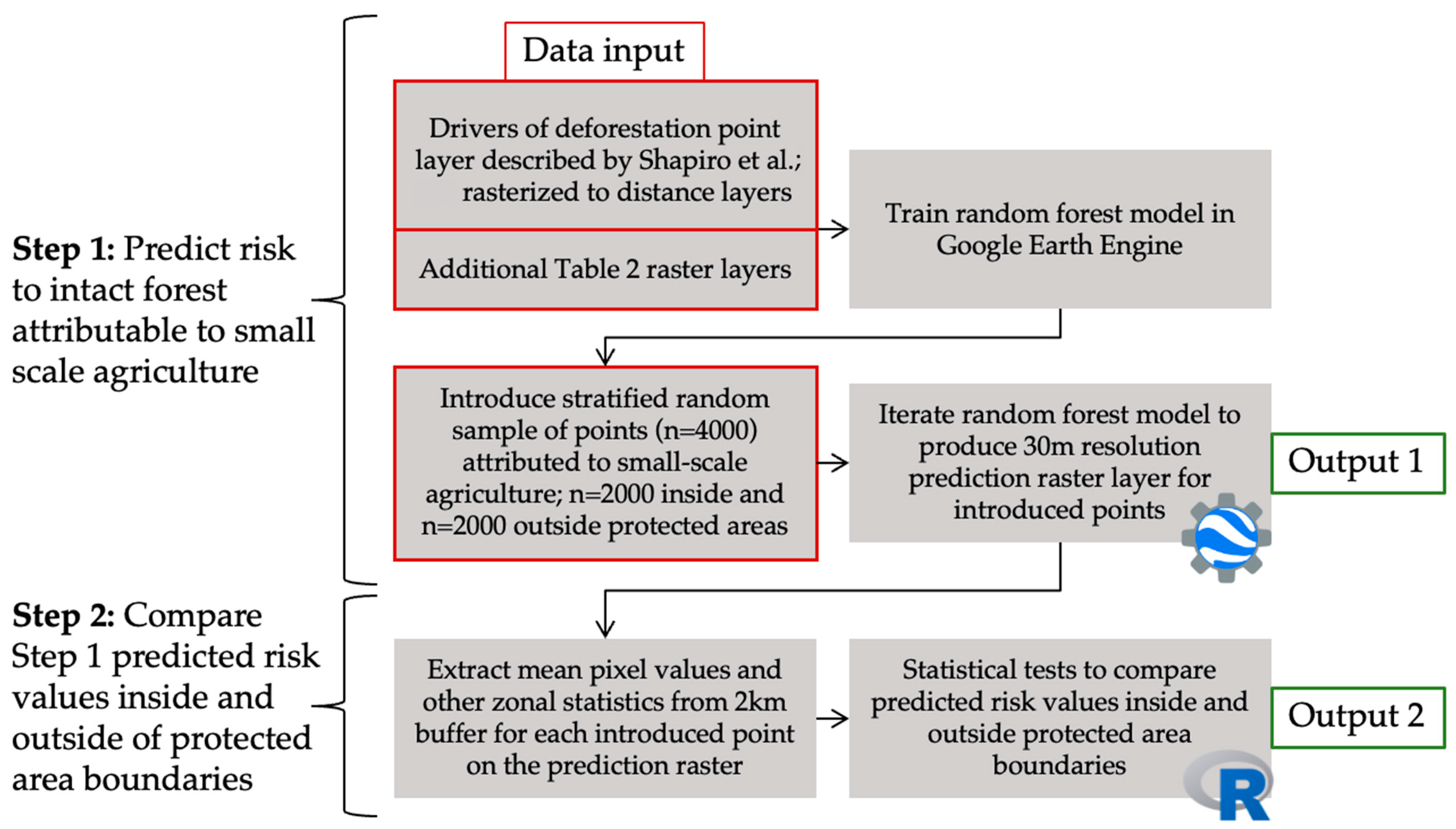
This study involved two major procedures: first, we predicted increased risk to intact forests from small-scale agriculture inside and outside of transboundary protected area complex boundaries with a stratified random sampling design within our study sites using a random forest model in Google Earth Engine. (This Google Earth Engine-based modeling work was conducted as part of a broader project implemented by the Food and Agriculture Organization of the United Nations (FAO) Forestry Division and Central African Forest Initiative (CAFI). The Earth Engine script was adapted from an algorithm originally developed as a land use planning support tool called Geoinformatics for Land Use Planning (Geo4LUP), a module for the System for Earth Observations, Data Access, Processing and Analysis for Land Monitoring (SEPAL), an open-source, cloud-based computing environment operated by FAO (https://sepal.io/ (accessed on 27 March 2022)). Second, we extracted zonal statistics from the prediction outputs and performed comparative statistical analyses in R (Version 4.3.2) to determine whether there were significant differences in the risk to intact forests inside and outside of the protected area boundaries. In this section, we first detail the study area, which included two Central African transboundary protected area complexes (Section 2.1), then the data used in this study (Section 2.2), and finally, the procedures used to predict the increased risk of deforestation and degradation resulting from small-scale agriculture. We then compared predicted risk inside and outside park boundaries (Section 2.3). Figure 3 presents a simple workflow outlining the major procedures taken for this study.

2.1. Study Area

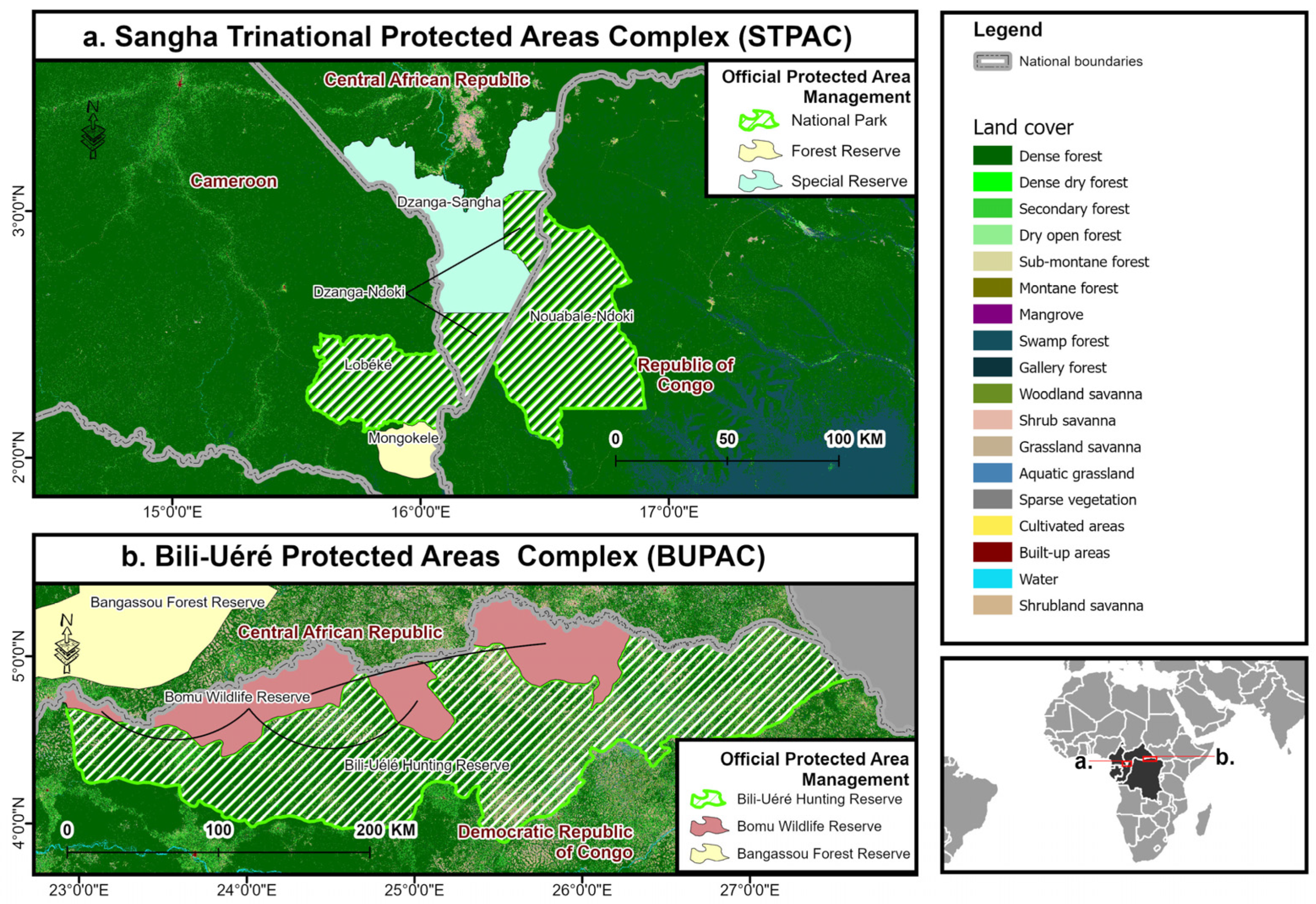
This study focuses on two transboundary protected area complexes: the Sangha Trinational Protected Areas Complex (STPAC) at the borders of Cameroon (CAM), Republic of Congo (COG) and Central African Republic (CAR) (Figure 4a), and the Bili-Uéré Protected Areas Complex (BUPAC) at the borders of the Democratic Republic of Congo (DRC) and Central African Republic (CAR) (Figure 4b).
STPAC includes three contiguous national parks (Dzanga-Ndoki National Park, Lobéke National Park, and Nouabale-Ndoki National Park) and two reserves (Dzanga-Sangha Special Dense Forest Reserve and Mongokele Forest Reserve), totaling approximately 1.1 million hectares (Figure 4a) [74,75,93]. Relative to BUPAC, there are more strict enforcement and resource-use restrictions in the STPAC, though variations exist between the three countries within the STPAC territory [75]. STPAC is home to rich biodiversity, including but not limited to forest elephants, the critically endangered western lowland gorilla, and chimpanzees [94].
Next, BUPAC is the largest contiguous protected area complex in the DRC, with approximately 4.3 million hectares (Bili-Uéré and Bomu Wildlife Reserve combined), and is also considered a part of the expansive DRC–CAR Garamba-Chinko-Bili transboundary complex, which shares an additional eastern border with South Sudan (Figure 4b) [62,94]. BUPAC is in a remote location and is considered under-studied relative to both (a) its ecological importance as a habitat for Eastern chimpanzees and forest elephants and (b) its geopolitical status at the intersection of three countries with considerable internal and regional conflict, with local communities facing significant socioeconomic challenges [62,94].
Across and within Central African countries, different protection categories receive varying levels of enforcement and prioritization from conservation entities and vary in their fundamental objectives. However, transboundary-protected area complexes often feature groupings of these mixed-protection categories and resource-use allowances [73,74,76], as is the case for both BUPAC and STPAC. In the case of STPAC, forest reserves such as the Dzanga-Sangha Special Dense Forest Reserve were intentionally established as a buffer area to ensure the protection of core forest and wildlife habitat in Dzanga-Ndoki National Park and Nouabalé-Ndoki National Park [74]. In the case of BUPAC, enforcement has historically been challenging due to remoteness and local and regional conflict [62,94]. While the hunting reserve corresponds with IUCN Category VI (protected area with sustainable use of natural resources), the Bomu Wildlife Reserve is considered for national biodiversity conservation prioritization [73], and the Bili-M’Bomu Core Area was prioritized for conservation by IUCN and African Wildlife Foundation (AWF), as it constitutes one of the most biodiversity-rich and relatively unimpacted zones of BUPAC [94].
These two Central African protected area complexes were selected for this study due to their transboundary locations and contiguous or adjacent inclusion of mixed-protected area categories within the same complex, constituting transboundary conservation landscapes [76]. BUPAC is under-studied [94], while new analyses for STPAC are also enabled by increasing the access, availability, and quality of EO data [75]. However, these two transboundary complexes feature different levels of national and international conservation priority, protection strictness and enforcement, and pressure from industrial and small-scale agriculture, timber, infrastructure, and other drivers of deforestation. For these reasons, we do not directly compare risk to intact forests in these sites but rather use them in our pilot to illustrate the risk to intact forests inside and outside transboundary protected area complexes in two distinct contexts within the same regional and landscape-level Central African forest system [21,58].

2.2. Data

The data analyzed to answer the research questions in this study included: (1) a previously derived point layer identifying the presence of eight agricultural and economic drivers of deforestation (e.g., infrastructure, small-scale agriculture, industrial agriculture, mining, etc.) [2]; and (2) an image stack of several additional biophysical, forest cover, and socioeconomic and governance raster layers.
First, the deforestation and degradation drivers point layer was critical for predicting the risk to intact forests attributable to small-scale agriculture. Although we summarize the key elements of the methodology behind the dataset in this section, readers are referred to the study by Shapiro et al. [2] for further detail regarding the replicable, open-source methodology and regional collaboration used to derive this point layer. FAO and regional partners collected and validated a dataset of n = 12,260 points extracted through stratified random sampling of a deforestation and degradation change map derived from dense time series analysis (calibration period of 2012–2020 for the monitoring period of 2015–2020) of Landsat satellite imagery using the Breaks for Additive Seasonal and Trend (BFAST) algorithm in six countries in Central Africa (CMR, CAR, DRC, COG, GAB, and GNQ) [2]. Of these samples, 3360 were identified as “change,” and one or more direct drivers were identified within a 2 km box centered at these coordinate locations [2] (p. 4).
Within the “change” points, change classes included deforestation, degradation, and stable points. Deforestation was defined as “a conversion of forest to other land use, or a permanent reduction in tree cover below an established forest definition threshold” [2] (p. 2). Although forest degradation is defined differently in many studies across the literature, we follow Saskaki and Putz [95] and Shapiro et al. [2] to define degradation as “a permanent or temporary change in forest cover that does not fall below the established forest definition threshold.” These thresholds are defined at the national level for each country and operationalized in the development of the drivers’ dataset, as presented in Shapiro et al. [2].
To identify which drivers were responsible for change at each point, a validation procedure was undertaken with ≥150 random points per change class (deforestation, degradation, stable) selected, with more points for larger map classes (n = 11,078), along with a random sample of stable points from all land cover classes (n = 1192). Table 1 presents the characteristics of driver types identified within the 2 km box centered at each coordinate location. As described by Shapiro et al. [2]:
“Visual interpretation of all points was performed using [Collect Earth Online], using available high-resolution optical image mosaics from Planet. Samples were uploaded to Collect Earth Online for visual interpretation by a group of 60 experts from the project technical committee [that] developed guidelines and agreed definitions … the validation phase [extended] over a period of 5 months, [as] each point was validated by three independent users to avoid user bias.” (p. 5)
Table 1. Key drivers of deforestation identified by the drivers of deforestation dataset [2] (p. 7, with example images from satellite imagery for each driver).
DriverCharacteristics
1Small-scale agricultureSmall irregular fields, generally less than 5 ha
2Industrial agricultureLarge regular fields of homogenous crops
3InfrastructureRoads or paths suitable for vehicular traffic
4SettlementsPresence of houses, buildings, huts, or other built-up features
5Artisanal forestryForest with small canopy gaps or perforations and felled trees
6Industrial forestryLarge consistent cuts (>5 ha),felled trees and logging roads
7Artisanal mineSmall muddy clearings, often along turbid waterways
8Industrial mineExtensive infrastructure, open pits, and exposed soils
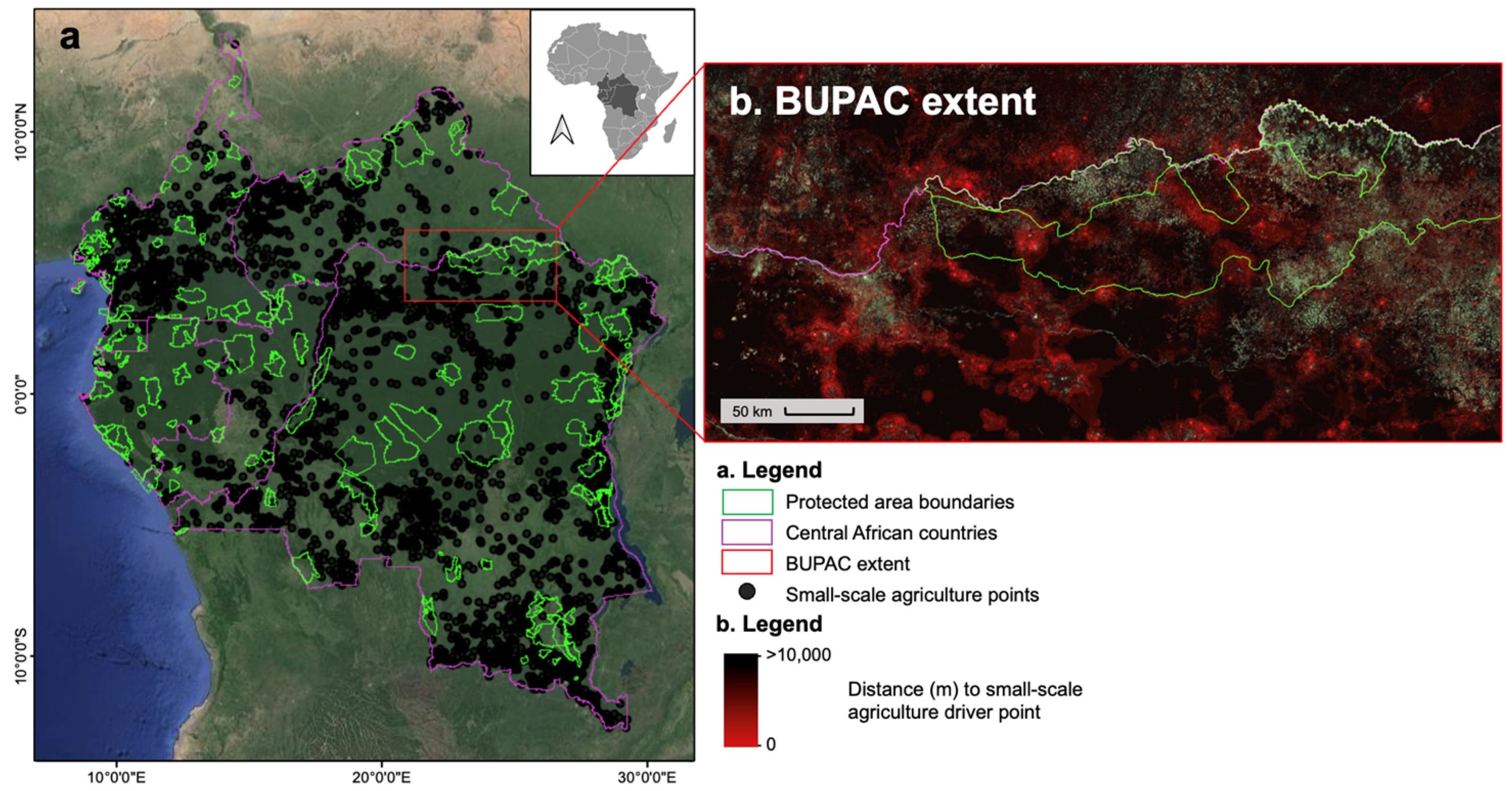
For this study, we used this dataset to create a distance raster layer for each driver, whereby the pixel value equaled the distance (meters) from the pixel center to the nearest driver point. These raster layers were used to train the random forest model to predict the risk to intact forests resulting from drivers, particularly small-scale agriculture, as the focus of this study. In addition to the proximate drivers themselves, to account for the multitude of additional factors that may contribute to risk to intact forests, we included a variety of other data layers for training the random forest model, as listed in Table 2. Figure 5 visualizes the distance raster layer relative to the point layer for the small-scale agriculture points defined in Table 1.

2.3. Procedures

The model training extent was determined by drawing a rectangular polygon encapsulating both BUPAC and STPAC and the surrounding unprotected landscape in Google Earth Engine. For the BUPAC extent, a gap on the eastern side of the park complex was not included to avoid any model prediction error caused by the border with South Sudan, where drivers data points are not available. After determining the training extent, two main sets of procedures were undertaken following the workflow as outlined in Figure 3: (1) predicting risk to intact forests attributable to small-scale agriculture, then (2) comparing risk inside and outside park boundaries.
First, we selected the random forest modeling approach for our prediction step for several reasons. We took an algorithmic approach, as the research questions for this study target deforestation and degradation risk prediction accuracy rather than estimation to explore the nature of relationships between variables, as would be central in a statistical modeling approach [107]. Second, considering the variety of data layers used in this study, including both raw and derived data, we determined that the decision tree approach—and random forest modeling in particular—was suitable, as it can account for data layers with varying distributions and has high prediction accuracy when applied in appropriate contexts [107]. Random forest was suitable in this context, as the predictions are within both the geographic and value bounds of the training data.
After model selection, the random forest model was then trained on the identified incidents of deforestation and forest degradation, proximity to the small-scale agriculture drivers data points [2] (Table 1, row 1), and additional biophysical, governance, and ecological data layers (Table 2). Predicted incidents of deforestation and forest degradation identified by the model were reclassified to probabilities to encapsulate risk [86,87]. After training the model on the image stack, a new set of small-scale agriculture points was introduced via stratified random sample (using ee.Image.stratifiedSample in Google Earth Engine with points generated on areas of intact forest) (total n = 4000) to predict the levels of increased risk associated with potential future small-scale agriculture. The stratified random sample of small-scale agriculture points included an equally sized random sample of sites inside and outside the park boundaries, accounting for the number of intact forest pixels. For both BUPAC and STPAC, n = 1000 intact forest points were sampled inside and outside the park boundary, resulting in n = 2000 points per complex and a total of n = 4000 points. The resulting predicted increased risk output was a raster layer at 30 m resolution, with one increased risk raster layer for each protected area complex.
The choice to use a stratified random sample of points inside and outside of the park boundary, incorporating equal measures of intact forest pixels, limited potential site-based factors and biases that might be introduced with a simple case study comparison of two locations: one within and one outside of the park boundary. While we did not employ matching techniques, as by Wolf et al. [72], or a counterfactual analysis design that would enable causal inference [27,81], our sampling design mitigates the potential pitfalls of a case study approach. For example, if non-random, equally sized (1 ha) hypothetical agricultural plot polygons were drawn on either side of the park boundary based on pre-established criteria or the matching technique, even with an equal or similar proportion of intact forests inside and outside of the border, there would still be some chance of bias towards the protected forest due to the possible confounding factor in model training of simply having more intact forests within the protected area or other factors that may not be considered.
Using the resulting predicted increased risk output 30 m resolution raster layer, the next major procedure involved statistically comparing risk values inside and outside of the protected area boundaries at each site. Comparisons were enabled by zonal statistics and statistical analysis of the derived predicted risk layer and compared with additional variables from the image stack, such as the distance from the protected area boundary. The risk output layers for each protected area complex at 30 m resolution were exported from Google Earth Engine for pre-analysis vector processing. The 4000 random points were reprojected to UTM35N, and a 2 km buffer was drawn around each point. The risk output layer was clipped to the 2 km buffers “inside park” and “outside park” points, so that mean increased-risk pixel values and other comparisons between the “inside park” and “outside park” raster values were conducted on equal area and from random locations within each (for clarity, the 2 km buffers are distinct from the 2 km boxes used to identify drivers around the training data). Zonal statistics from the masked raster were then extracted for each 2 km point buffer for analysis. The resulting shapefiles with zonal statistics from the “inside” and “outside” were exported and merged into one dataset (n = 4000) for analysis in R.
Then, the risk-pixel zonal statistics for each random 2 km zone were compared by “inside” and “outside” of park boundary using t-tests and regression analysis with robust standard errors, as the increased risk values demonstrated heteroskedasticity, with variance increasing as the risk values increased. Simple regression analysis included, for instance, estimation of the influence of proximity to the protected area boundary on predicted risk via d e f o r r i s k i = β 0 + β 1 p a d i s t i + β 2 X 1 i + ε i , where the dependent variable, d e f o r r i s k i , is the predicted risk value at pixel i , and independent variables include p a d i s t i , as well as the distance to the protected area boundary from the centroid of pixel i , and a vector of controls X 1 i (Table 2), including an inside vs. outside protected area dummy variable. ε i is the error term. In the Results section, we visualize the comparison of predicted risk values inside and outside of protected areas at our two sites with descriptive boxplots and kernel density estimation, which is a common non-parametric technique for visualizing the smoothed shape of a distribution [108]. The results are presented with disaggregation by site, protected area category, and country in the transboundary system.
We also performed analyses to understand the spatial distributions of the predicted risk values considering protected area boundaries at both sites. K-means clustering was used to illustrate where spatial groupings of similar risk values were evident relative to protected area and international boundaries. K-means clustering is commonly used for partitioning data into distinct subsets, sorting n (number of points) into k (number of groups) by iteratively minimizing within-cluster sum of squared distances from each group’s centroid until a predetermined number of iterations is reached or the minimized distances no longer change significantly, resulting in each data point being sorted into one distinct group [109,110,111]. Although k-means clustering and its visualization were useful in our study for understanding the spatial distribution of predicted risk relative to the protected area and international boundaries, the technique has well-known limitations and sensitivities, such as sensitivity to outliers and specification of k clusters [109,110]. We sought to address these limitations in arriving at a final visualization. For instance, because k-means clustering is sensitive to assigned starting points for iteration, we compared outputs from randomized initialization (iterations = 1000) and the commonly used k-means++ algorithm as described by Arthur and Vassilvitskii [112]. These resulted in similar outputs with k = 4 clusters (the ratios of the between-cluster to the total sum of squares at 0.612 and 0.611, respectively), and we ultimately presented the random initialization output in our Results section.

3. Results

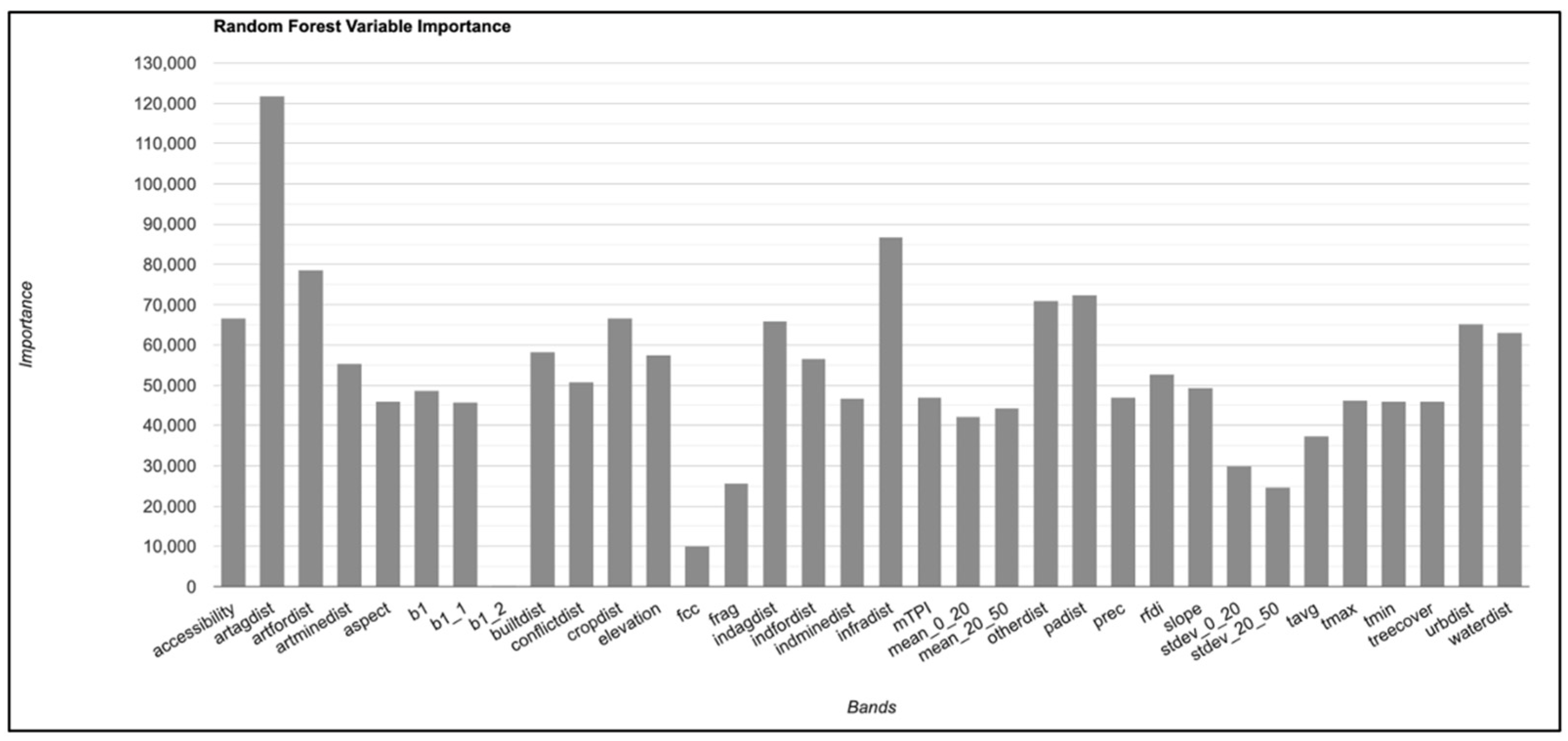
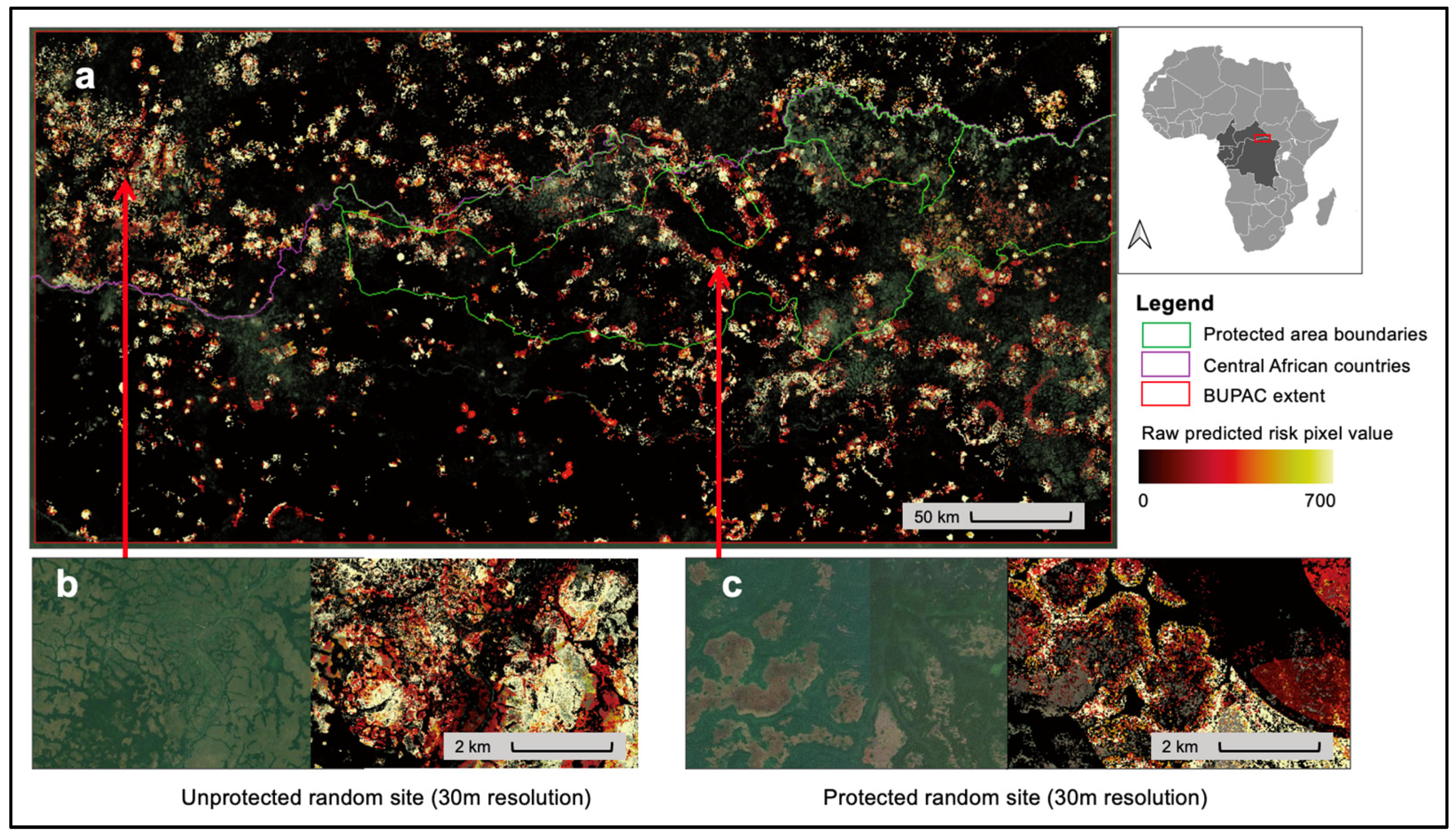
In this section, we first present the results from the prediction of increased risk of deforestation and degradation to intact forests, then the results of comparative analysis using zonal statistics. First, as anticipated and as demonstrated in the random forest variable importance chart in Figure 6, the model indicated that small-scale agriculture and infrastructure are the variables in the image stack for which the prediction error would increase the most if they were removed from the model. Figure 7 provides a visual of the risk output layer for BUPAC, from which zonal statistics were then extracted to the 2 km buffers (n = 4000).
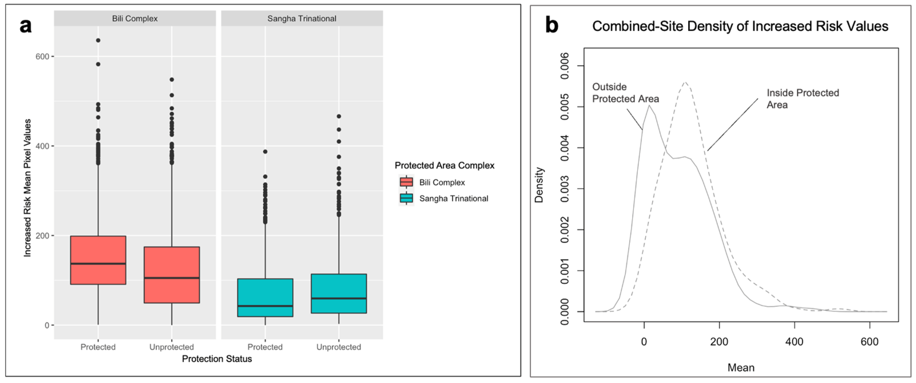
Next, our results from the comparative statistical analysis were mixed in terms of aligning with our hypotheses. Select results, including the summary statistics and t-test results of the comparative analysis between the “inside park” and “outside park” risk-pixel values, are presented in Table 3. These results are also visualized in Figure 8 in the boxplots (Figure 8a) and kernel density plot (Figure 8b).
The predicted increased risk to intact forests resulting from small-scale agriculture was significantly lower for intact forests inside the STPAC boundaries than for unprotected intact forests in that landscape (p < 0.01), which aligned with our hypothesis, H1. In contrast, we were surprised by the finding that the increased risk of deforestation of intact forests from small-scale agriculture was significantly higher inside the BUPAC boundaries than for the unprotected forests outside the boundaries (p < 0.01), which contradicted our hypothesis, H1.
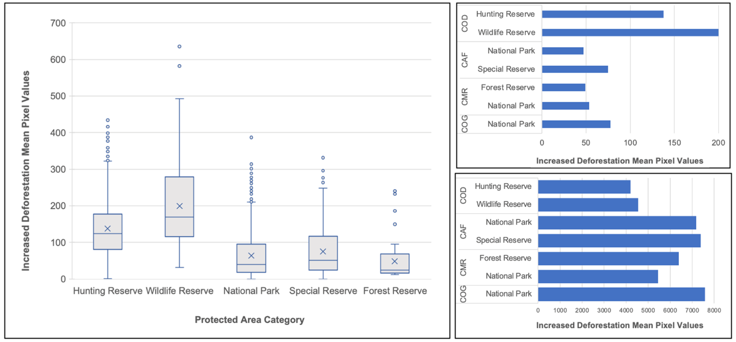
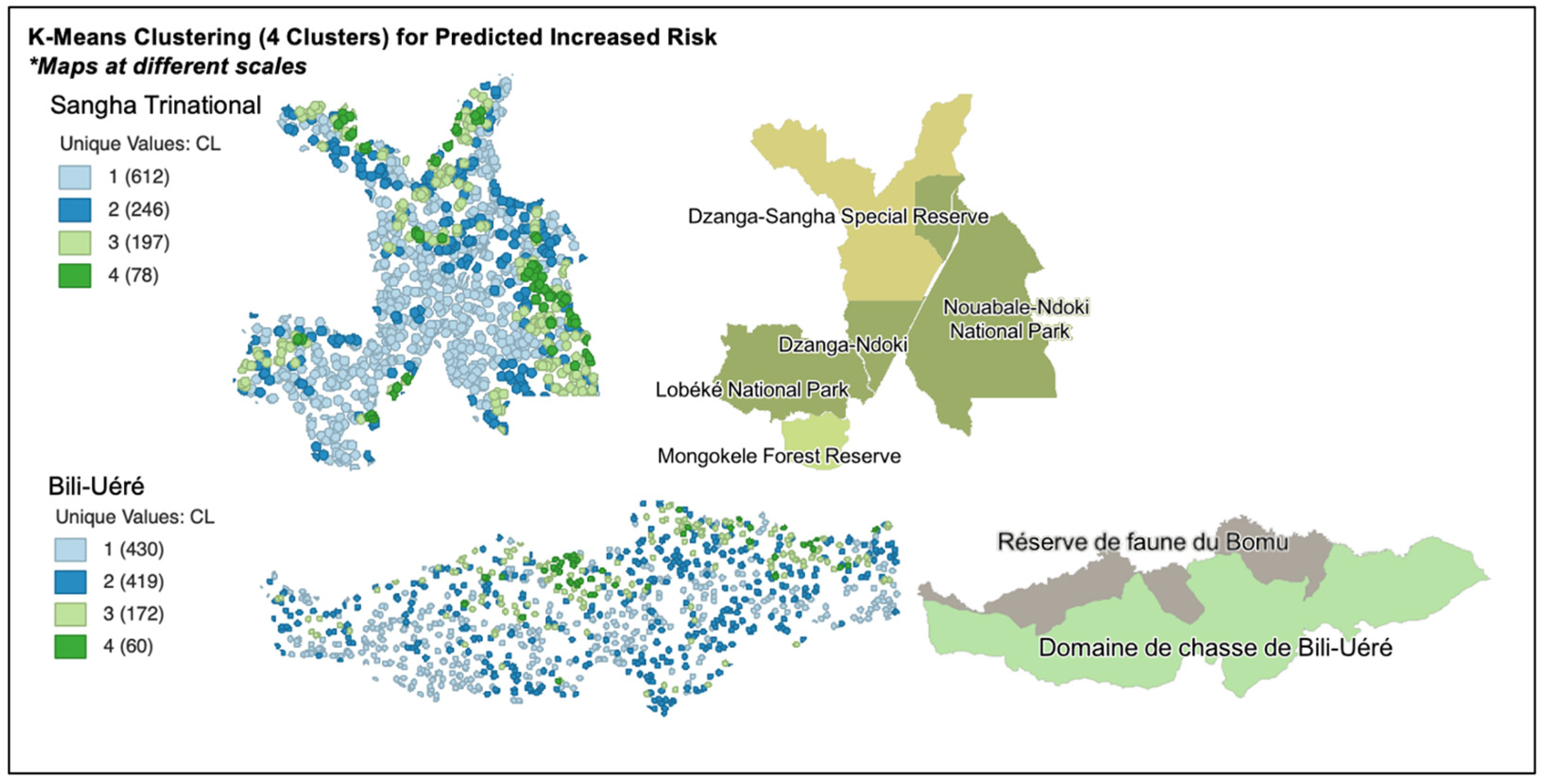
Figure 9 and Figure 10 descriptively and visually present the mean predicted increased risk to intact forest values by protected area category, which supports our hypothesis, H2. These are not generalizable to other protected area categories outside of BUPAC and STPAC but provide further useful information regarding the categories of protected area that demonstrated the highest mean and maximum value of predicted increased risk resulting from small-scale agriculture in the study areas (Figure 9). Figure 10 visualizes the spatial distribution of high predicted increased risk within each protected area complex using k-means clustering, with dark green points indicating clusters of higher predicted risk and dark blue points indicating clusters of lower predicted risk. Higher risk in BUPAC corresponds with the Bomu Wildlife Reserve, which also shares the international border with CAR. The higher risk in STPAC corresponds with the Dzangha-Sangha Special Reserve of CAR, which was historically intended to be a buffer zone for the Dzangha-Ndoki National Park and the Nouabale-Ndoki National Park in COG.
Finally, within the random forest model for predicting increased risk, distance from protected area boundary followed behind only small-scale agriculture, artisanal forestry (timber harvesting), and infrastructure development as a key factor for predicting the increased risk of deforestation and degradation of intact forests (Figure 6). In the regression, proximity to the BUPAC protected area border was associated with increased risk to intact forests from small-scale agriculture when the forest was inside the protected area (beta = 20.31, p < 0.001). For forests outside of the protected area, the distance to the protected area boundary was not significant (p > 0.15). Distance to the protected area boundary was not significant for STPAC (p > 0.25).

4. Discussion

Returning to our research questions and hypotheses, we initially hypothesized the increased risk to intact forests from small-scale agriculture to be lower inside than outside the protected area complex boundaries for both sites [18,29]. We postulated that considering that protected areas are included in the model training, if BUPAC is effective in its conservation objectives, the algorithm would be more likely to predict a lower risk of deforestation and degradation inside the park boundary, ceteris paribus. We anticipated that, due to the higher-strictness configuration of reserves and national parks at STPAC compared to BUPAC, the increased risk levels would be higher by magnitude at BUPAC, which features hunting reserves and wildlife reserves. STPAC also features nature reserves intentionally spatially arranged as buffer zones for increased protection of the national parks [74], which we expected to further lower the predicted risk inside the protected area boundaries.
There are several possible aspects that can explain the finding of higher risk inside park boundaries for BUPAC, based not only on factors consistent with the evidence in the literature, such as conflict and complex underlying drivers at the site [18,54,55] but also due to the management realities at BUPAC [62]. First, the higher risk values inside protected area boundaries could be simply a function of the less-strict protection category of the Bili-Uéré Hunting Reserve that aligns with Category VI—protected area with sustainable use of natural resources [73]. The importance of the category as a factor is demonstrated in Figure 9 and aligns with existing evidence, such as the findings of Tranquilli et al. [18]. However, this does not necessarily explain the overall increased risk inside the BUPAC boundaries when also considering the spatial configuration of the protected area complex, including the adjacent Bomu Wildlife Reserve. Thus, higher risk inside park boundaries is more likely a combination of several factors, including regional, local, and cross-border conflict and instability (Figure 2), enforcement challenges, and the overall remoteness of the site [54,62,94]. Cross-border traffic and population displacement between CAR and northern DRC is not only a product of conflict, but also climate change, as BUPAC becomes a grazing area for pastoralists and others moving northwards. Furthermore, law enforcement challenges and site remoteness favor the expansion of mining camps, particularly in the western areas of BUPAC [113], which can compound with other driver pressures to constitute “driver archetypes” [2,43] or drivers that are found together. For example, mining camps may be supported by nearby agriculture, leading to increased potential threats from small-scale agriculture as a knock-on threat from mining, enabled by enforcement challenges in the landscape.
In addition to the issues of protected area category and spatial configuration of protected areas within each site, and of course the contextual factors that create a different mix of driver pressure circumstances for each transboundary complex, there is also a question of the influence of the protected area borders themselves [114]. The finding of an association between proximity to the BUPAC protected area and increased risk to intact forests from small-scale agriculture inside the protected area follows previous studies that have assessed the influence of border effects and suggest that these could have different implications inside and outside protected area boundaries—an area for future research [115].
Again, revisiting our initial research questions and hypotheses, our findings suggest that there may be significant differences in the level of threat to intact forests caused by deforestation-driver activities, such as small-scale agriculture expansion, between protected and unprotected forests, and in some cases, risk of a deforestation or degradation incident resulting from small-scale agriculture can actually be higher for protected forests. This finding speaks directly to the debate in the protected areas effectiveness literature [13,14]. However, addressing the second research question and following the perspectives of Cumming [15], Green et al. [20], and Du et al. [19], there are a multitude of social, ecological, and other factors that may be contributing to protected areas ineffectiveness—in addition to its success stories. In the case of BUPAC, heightened pressure from small-scale agricultural expansion may be driven, for example, by better soil suitability for agriculture inside the parks than in surrounding areas [35]. Pressure could also stem from nearby conflict or social dimensions like park legitimacy [54,55,91].
The results of this pilot study provide direction for future research. For example, causal inference and spatial econometrics techniques could be applied to address the role of spatial configuration of protected area categories in transboundary complexes and guide land use planning efforts. Future research could also explore alternative algorithmic approaches, such as neural nets, to determine if there is any change in the predicted risk to intact forests resulting from small-scale agriculture associated with an alternative modeling technique. Future research is also needed to clarify how and when designated protection categories within a broader complex do not align with realities on the ground. For example, our results indicated that the highest predicted increased risk to intact forests associated with small-scale agriculture in BUPAC was not Bili-Uéré Hunting Reserve but within Bomu Wildlife Reserve, which, according to Pélissier et al. [73] and official protected area categorizations, should have a greater level of enforcement and resource-use restriction. However, as Ondoua Ondoua et al. [62] describe, militia operations, poaching, and trafficking in the area may exceed the capacity of local enforcement. Similarly, in STPAC, the Nouabale-Ndoki National Park in COG presented higher predicted increased risk to intact forests than other less-strict categorizations within STPAC. These variations highlight the ways in which enforcement and prioritization dynamics can be influenced by transboundary contexts. As scholars such as Mason et al. [32], Schoon [57], and Petursson et al. [78] have previously described, the varying national governance, institutional, political, economic, and social contexts, and indeed the varying degrees of conservation prioritization on each side of a border may also play critical roles in the level of protected area monitoring and effort. Furthermore, those factors can also play a role in the status of food security, socioeconomic conditions, and pressures to convert intact forests to other uses that can support livelihoods [75]. While this study highlights the need for future research to understand these transboundary dynamics, considering these factors, this study further builds a foundation for future research assessing within-country variations in predicted increased risk from small-scale agriculture and other drivers by national protected area categorization in Central Africa. For example, within-country analysis could also compare context-specific adaptations and innovations to the protected areas model, such as community-managed forests in DRC, and the procedures used in this study can be repeated for country-level disaggregation of protected area categories for DRC [116]. This also has important implications for reducing the risks and potential threats to biodiversity within protected areas such as BUPAC [94].

5. Conclusions

This pilot study contributed to debates within three overlapping literatures: drivers of deforestation and forest degradation [2,11], protected areas effectiveness [12,13,14,15,16,17,18,24], and comparative analysis using EO data inside and outside of protected areas boundaries and across international boundaries [84,85,86]. This study contributed to the literature by providing insights regarding the potential influence of spatial configuration of protection types and categories on the effectiveness of under-studied transboundary protected area complexes for reducing the risk to intact forests attributed to small-scale agriculture, in addition to the influence of international boundaries. Following existing theory and evidence [18,29], we asked whether there are significant differences in the levels of threat to intact forests attributable to small-scale agriculture expansion pressure between protected and unprotected forests in transboundary Central African protected area complexes. The study further asked whether protected area categorization and the configuration of these categories within a protected area complex can play a role in levels of predicted risk from small-scale agriculture. We predicted an increased risk to intact forests from small-scale agriculture using a random forest algorithm iterated over an image stack of biophysical, ecological, and social data, in addition to a drivers of deforestation dataset derived through an open-source, replicable methodology and regional collaboration [2]. Zonal statistics from a stratified random sample of points then enabled comparison of predicted risk for n = 4000 equally sized sites inside and outside of the boundaries of two transboundary Central African protected area complexes. Our findings suggest varied effectiveness of protected area complexes in reducing the predicted risk of deforestation and degradation to intact forests attributed to small-scale agricultural conversion by both site and category of protected areas. These early results provide direction for future research and suggest that transboundary protected area complexes could benefit from careful management and planning consideration of optimal spatial configuration of mixed resource-use restriction categories within the same complex. As the 30 by 30 Global Biodiversity Framework places protected areas increasingly at the center of global biodiversity conservation discussions [32,90,91], our results further emphasize the importance of spatial planning, the need to balance local livelihoods and resource needs, and transboundary considerations in effective forest conservation efforts in Central Africa.

Author Contributions

Conceptualization, K.P.B.; methodology, K.P.B. and A.C.S.; software, K.P.B. and A.C.S.; validation, K.P.B.; formal analysis, K.P.B. and A.C.S.; investigation, K.P.B.; resources, A.C.S. and R.d.; data curation, K.P.B. and A.C.S.; writing—original draft preparation, K.P.B.; writing—review and editing, K.P.B., A.C.S., R.d. and J.M.K.; visualization, K.P.B. and J.M.K.; funding acquisition, K.P.B., A.C.S. and R.d. All authors have read and agreed to the published version of the manuscript.

Funding

This research was funded by the Food and Agriculture Organization of the United Nations (FAO) (Grant FAO-Penn State 2022 “Drivers of Deforestation” OSP no. 228015) through the Central African Forest Initiative (CAFI). This material is also supported by the National Science Foundation Research Trainee Program LandscapeU and NRT Traineeship Fellowship (Grant #DGE 1828822) in addition to the NASA PA Space Grant Consortium Graduate Research Fellowship (Award Number 80NSSC20M0097).

Data Availability Statement

Google Earth Engine assets produced by CAFI/FAO are available from the data repository: https://data.congo.dddafrica.info (accessed on 27 March 2022). This study resulted in the development of several data products available upon request: (1) the zonal statistics for inside and outside park boundaries; (2) the intact forest raster for the study area; (3) the risk output raster for the study area; and (4) the risk distance raster layer and other vector and raster files produced in steps throughout the research process.

Acknowledgments

We thank Nathan Piekielek, Caroline Merle, and Pierrick Rambaud for reviewing early versions of this analysis and related reports. Edwin Sabuhoro and Carter Hunt provided supervisory support to the project. The authors also thank two anonymous reviewers whose suggestions improved the paper.

Conflicts of Interest

The authors declare no conflicts of interest.

References

  1. Harris, N.L.; Gibbs, D.A.; Baccini, A.; Birdsey, R.A.; de Bruin, S.; Farina, M.; Fatoyinbo, L.; Hansen, M.C.; Herold, M.; Houghton, R.A.; et al. Global maps of twenty-first century forest carbon fluxes. Nat. Clim. Chang. 2021, 11, 234–240. [Google Scholar] [CrossRef]
  2. Shapiro, A.; d’Annunzio, R.; Desclée, B.; Jungers, Q.; Kondjo, H.K.; Iyanga, J.M.; Gangyo, F.I.; Nana, T.; Obame, C.V.; Kipute, D.D. Small scale agriculture continues to drive deforestation and degradation in fragmented forests in the Congo Basin (2015–2020). Land Use Policy 2023, 134, 106922. [Google Scholar] [CrossRef]
  3. Justice, C.; Wilkie, D.; Zhang, Q.; Brunner, J.; Donoghue, C. Central African forests, carbon and climate change. Clim. Res. 2001, 17, 229–246. [Google Scholar] [CrossRef]
  4. Mitchard, E.T.A. The tropical forest carbon cycle and climate change. Nature 2018, 559, 527–534. [Google Scholar] [CrossRef] [PubMed]
  5. Vieilledent, G.; Grinand, C.; Rakotomalala, F.A.; Ranaivosoa, R.; Rakotoarijaona, J.-R.; Allnutt, T.F.; Achard, F. Combining global tree cover loss data with historical national forest cover maps to look at six decades of deforestation and forest fragmentation in Madagascar. Biol. Conserv. 2018, 222, 189–197. [Google Scholar] [CrossRef]
  6. Branthomme, A.; Merle, C.; Kindgard, A.; Lourenço, A.; Ng, W.; D’Annunzio, R.; Shapiro, A. How Much Do Large-Scale and Small-Scale Farming Contribute to Global Deforestation? FAO: Rome, Italy, 2023. [CrossRef]
  7. Curtis, P.G.; Slay, C.M.; Harris, N.L.; Tyukavina, A.; Hansen, M.C. Classifying drivers of global forest loss. Science 2018, 361, 1108–1111. [Google Scholar] [CrossRef] [PubMed]
  8. Tyukavina, A.; Hansen, M.C.; Potapov, P.; Parker, D.; Okpa, C.; Stehman, S.V.; Kommareddy, I.; Turubanova, S. Congo Basin forest loss dominated by increasing smallholder clearing. Sci. Adv. 2018, 4, eaat2993. [Google Scholar] [CrossRef]
  9. Linard, C.; Tatem, A.J.; Gilbert, M. Modelling spatial patterns of urban growth in Africa. Appl. Geogr. 2013, 44, 23–32. [Google Scholar] [CrossRef]
  10. Bele, M.Y.; Sonwa, D.J.; Tiani, A.-M. Adapting the Congo Basin forests management to climate change: Linkages among biodiversity, forest loss, and human well-being. For. Policy Econ. 2015, 50, 1–10. [Google Scholar] [CrossRef]
  11. Pendrill, F.; Gardner, T.A.; Meyfroidt, P.; Persson, U.M.; Adams, J.; Azevedo, T.; Bastos Lima, M.G.; Baumann, M.; Curtis, P.G.; De Sy, V.; et al. Disentangling the numbers behind agriculture-driven tropical deforestation. Science 2022, 377, eabm9267. [Google Scholar] [CrossRef]
  12. Blom, A. An estimate of the costs of an effective system of protected areas in the Niger Delta? Congo Basin Forest Region. Biodivers. Conserv. 2004, 13, 2661–2678. [Google Scholar] [CrossRef]
  13. Mora, C.; Sale, P. Ongoing global biodiversity loss and the need to move beyond protected areas: A review of the technical and practical shortcomings of protected areas on land and sea. Mar. Ecol. Prog. Ser. 2011, 434, 251–266. [Google Scholar] [CrossRef]
  14. Hill, R.; Miller, C.; Newell, B.; Dunlop, M.; Gordon, I.J. Why biodiversity declines as protected areas increase: The effect of the power of governance regimes on sustainable landscapes. Sustain. Sci. 2015, 10, 357–369. [Google Scholar] [CrossRef]
  15. Cumming, G.S. The relevance and resilience of protected areas in the Anthropocene. Anthropocene 2016, 13, 46–56. [Google Scholar] [CrossRef]
  16. Tulloch, V.J.; Tulloch, A.I.; Visconti, P.; Halpern, B.S.; Watson, J.E.; Evans, M.C.; Auerbach, N.A.; Barnes, M.; Beger, M.; Chadès, I.; et al. Why do we map threats? Linking threat mapping with actions to make better conservation decisions. Front. Ecol. Environ. 2015, 13, 91–99. [Google Scholar] [CrossRef] [PubMed]
  17. Laurance, W.F.; Sayer, J.; Cassman, K.G. Agricultural expansion and its impacts on tropical nature. Trends Ecol. Evol. 2014, 29, 107–116. [Google Scholar] [CrossRef] [PubMed]
  18. Tranquilli, S.; Abedi-Lartey, M.; Abernethy, K.; Amsini, F.; Asamoah, A.; Balangtaa, C.; Blake, S.; Bouanga, E.; Breuer, T.; Brncic, T.M.; et al. Protected Areas in Tropical Africa: Assessing Threats and Conservation Activities. PLoS ONE 2014, 9, e114154. [Google Scholar] [CrossRef] [PubMed]
  19. Du, W.; Penabaz-Wiley, S.; Njeru, A.; Kinoshita, I. Models and Approaches for Integrating Protected Areas with Their Surroundings: A Review of the Literature. Sustainability 2015, 7, 8151–8177. [Google Scholar] [CrossRef]
  20. Green, J.M.H.; Larrosa, C.; Burgess, N.D.; Balmford, A.; Johnston, A.; Mbilinyi, B.P.; Platts, P.J.; Coad, L. Deforestation in an African biodiversity hotspot: Extent, variation and the effectiveness of protected areas. Biol. Conserv. 2013, 164, 62–72. [Google Scholar] [CrossRef]
  21. Brodie, J.F.; Mohd-Azlan, J.; Chen, C.; Wearn, O.R.; Deith, M.C.; Ball, J.G.; Slade, E.M.; Burslem, D.F.; Teoh, S.W.; Williams, P.J.; et al. Landscape-scale benefits of protected areas for tropical biodiversity. Nature 2023, 620, 807–812. [Google Scholar] [CrossRef]
  22. World Database on Protected Areas (WDPA). United Nations Environment World Conservation Monitoring Centre (UNEP-WCMC). 2022. Available online: https://www.unep-wcmc.org/resources-and-data/wdpa (accessed on 30 March 2022).
  23. Central African Forest Initiative (CAFI). Drivers of Forest Change in Congo Basin. Drivers of Deforestation and Forest Degradation Database. 2022. Available online: https://data.congo.dddafrica.info (accessed on 27 March 2022).
  24. Rodrigues, A.S.L.; Cazalis, V. The multifaceted challenge of evaluating protected area effectiveness. Nat. Commun. 2020, 11, 5147. [Google Scholar] [CrossRef] [PubMed]
  25. Munanura, I.E.; Backman, K.F.; Sabuhoro, E.; Powell, R.B.; Hallo, J.C. The perceived forms and drivers of forest dependence at Volcanoes National Park, Rwanda. Environ. Sociol. 2018, 4, 343–357. [Google Scholar] [CrossRef]
  26. Dudley, N.; Parrish, J.D.; Redford, K.H.; Stolton, S. The revised IUCN protected area management categories: The debate and ways forward. Oryx 2010, 44, 485–490. [Google Scholar] [CrossRef]
  27. Nelson, A.; Chomitz, K.M. Effectiveness of Strict vs. Multiple Use Protected Areas in Reducing Tropical Forest Fires: A Global Analysis Using Matching Methods. PLoS ONE 2011, 6, e22722. [Google Scholar] [CrossRef]
  28. Stoudmann, N.; Waeber, P.O.; Savilaakso, S.; Wilmé, L.; Kendal, D.; Adams, M. Socioeconomic and environmental impacts of anthropogenic activities within multiple use protected areas: A systematic map protocol. Open Sci. Framew. 2021. [CrossRef]
  29. Buřivalová, Z.; Hart, S.J.; Radeloff, V.C.; Srinivasan, U. Early warning signs of forest loss in protected areas. Curr. Biol. 2021, 31, 4620–4626.e3. [Google Scholar] [CrossRef]
  30. Burgess, R.; Costa, F.; Olken, B.A. The power of the state: National borders and the deforestation of the Amazon. Unpubl. Pap. Lond. Sch. Econ. 2016. [Google Scholar] [CrossRef]
  31. Laurance, W.F.; Carolina Useche, D.; Rendeiro, J.; Kalka, M.; Bradshaw, C.J.A.; Sloan, S.P.; Laurance, S.G.; Campbell, M.; Abernethy, K.; Alvarez, P.; et al. Averting biodiversity collapse in tropical forest protected areas. Nature 2012, 489, 290–294. [Google Scholar] [CrossRef]
  32. Mason, N.; Ward, M.; Watson, J.E.M.; Venter, O.; Runting, R.K. Global opportunities and challenges for transboundary conservation. Nat. Ecol. Evol. 2020, 4, 694–701. [Google Scholar] [CrossRef]
  33. Gorelick, N.; Hancher, M.; Dixon, M.; Ilyushchenko, S.; Thau, D.; Moore, R. Google Earth Engine: Planetary-scale geospatial analysis for everyone. Remote Sens. Environ. 2017, 202, 18–27. [Google Scholar] [CrossRef]
  34. Hansen, M.C.; Potapov, P.V.; Moore, R.; Hancher, M.; Turubanova, S.A.; Tyukavina, A.; Thau, D.; Stehman, S.V.; Goetz, S.J.; Loveland, T.R.; et al. High-Resolution Global Maps of 21st-Century Forest Cover Change. Science 2013, 342, 850–853. [Google Scholar] [CrossRef] [PubMed]
  35. Peter, B.G.; Messina, J.P.; Lin, Z.; Snapp, S.S. Crop climate suitability mapping on the cloud: A geovisualization application for sustainable agriculture. Sci. Rep. 2020, 10, 15487. [Google Scholar] [CrossRef] [PubMed]
  36. Chicas, S.D.; Omine, K.; Saqui, P. CLASlite algorithms and social surveys to asses and identify deforestation and forest degradation in Toledo’s protected areas and forest ecosystems, Belize. Appl. Geogr. 2016, 75, 144–155. [Google Scholar] [CrossRef]
  37. Nyeko, M. GIS and Multi-Criteria Decision Analysis for Land Use Resource Planning. J. Geogr. Inf. Syst. 2012, 4, 341–348. [Google Scholar] [CrossRef]
  38. Yalew, S.G.; van Griensven, A.; van der Zaag, P. AgriSuit: A web-based GIS-MCDA framework for agricultural land suitability assessment. Comput. Electron. Agric. 2016, 128, 1–8. [Google Scholar] [CrossRef]
  39. Yan, Y.; Zhuang, Q.; Zan, C.; Ren, J.; Yang, L.; Wen, Y.; Zeng, S.; Zhang, Q.; Kong, L. Using the Google Earth Engine to rapidly monitor impacts of geohazards on ecological quality in highly susceptible areas. Ecol. Indic. 2021, 132, 108258. [Google Scholar] [CrossRef]
  40. Zolekar, R.B.; Bhagat, V.S. Multi-criteria land suitability analysis for agriculture in hilly zone: Remote sensing and GIS approach. Comput. Electron. Agric. 2015, 118, 300–321. [Google Scholar] [CrossRef]
  41. Bialowolski, P.; Rakotobe, D.; Marelli, A.; Roggeri, P.; Paolini, C. Use of the IMET tool in the evaluation of protected area management effectiveness in Central Africa. J. Environ. Manag. 2023, 326, 116680. [Google Scholar] [CrossRef]
  42. Bernhard, K.P.; Shapiro, A.C.; Hunt, C.A. Drivers of tropical deforestation: A global review of methodological approaches and analytical scales. Biodivers. Conserv. 2023. [Google Scholar] [CrossRef]
  43. Molinario, G.; Hansen, M.C.; Potapov, P.V.; Tyukavina, A.; Stehman, S.; Barker, B.; Humber, M. Quantification of land cover and land use within the rural complex of the Democratic Republic of Congo. Environ. Res. Lett. 2017, 12, 104001. [Google Scholar] [CrossRef]
  44. Molinario, G.; Hansen, M.; Potapov, P.; Tyukavina, A.; Stehman, S. Contextualizing Landscape-Scale Forest Cover Loss in the Democratic Republic of Congo (DRC) between 2000 and 2015. Land 2020, 9, 23. [Google Scholar] [CrossRef]
  45. Ferrer Velasco, R.; Köthke, M.; Lippe, M.; Günter, S. Scale and context dependency of deforestation drivers: Insights from spatial econometrics in the tropics. PLoS ONE 2020, 15, e0226830. [Google Scholar] [CrossRef] [PubMed]
  46. Shapiro, A.C.; Bernhard, K.P.; Zenobi, S.; Müller, D.; Aguilar-Amuchastegui, N.; d’Annunzio, R. Proximate Causes of Forest Degradation in the Democratic Republic of the Congo Vary in Space and Time. Front. Conserv. Sci. 2021, 2, 690562. [Google Scholar] [CrossRef]
  47. Mayer, A.L. Family forest owners and landscape-scale interactions: A review. Landsc. Urban Plan. 2019, 188, 4–18. [Google Scholar] [CrossRef]
  48. De Sy, V.; Herold, M.; Achard, F.; Avitabile, V.; Baccini, A.; Carter, S.; Clevers, J.G.P.W.; Lindquist, E.; Pereira, M.; Verchot, L. Tropical deforestation drivers and associated carbon emission factors derived from remote sensing data. Environ. Res. Lett. 2019, 14, 094022. [Google Scholar] [CrossRef]
  49. Slagter, B.; Reiche, J.; Marcos, D.; Mullissa, A.; Lossou, E.; Peña-Claros, M.; Herold, M. Monitoring direct drivers of small-scale tropical forest disturbance in near real-time with Sentinel-1 and -2 data. Remote Sens. Environ. 2023, 295, 113655. [Google Scholar] [CrossRef]
  50. Angelsen, A.; Kaimowitz, D. Rethinking the Causes of Deforestation: Lessons from Economic Models. World Bank Res. Obs. 1999, 14, 73–98. [Google Scholar] [CrossRef]
  51. Meyfroidt, P. Approaches and terminology for causal analysis in land systems science. J. Land Use Sci. 2016, 11, 501–522. [Google Scholar] [CrossRef]
  52. Francis, R.A.; Millington, J.D.A.; Perry, G.L.W.; Minor, E.S. The Routledge Handbook of Landscape Ecology, 1st ed.; Routledge: London, UK, 2021. [Google Scholar] [CrossRef]
  53. Newman, E.A.; Kennedy, M.C.; Falk, D.A.; McKenzie, D. Scaling and Complexity in Landscape Ecology. Front. Ecol. Evol. 2019, 7, 293. [Google Scholar] [CrossRef]
  54. De Merode, E.; Smith, K.H.; Homewood, K.; Pettifor, R.; Rowcliffe, M.; Cowlishaw, G. The impact of armed conflict on protected-area efficacy in Central Africa. Biol. Lett. 2007, 3, 299–301. [Google Scholar] [CrossRef]
  55. Butsic, V.; Baumann, M.; Shortland, A.; Walker, S.; Kuemmerle, T. Conservation and conflict in the Democratic Republic of Congo: The impacts of warfare, mining, and protected areas on deforestation. Biol. Conserv. 2015, 191, 266–273. [Google Scholar] [CrossRef]
  56. Clerici, N.; Armenteras, D.; Kareiva, P.; Botero, R.; Ramírez-Delgado, J.P.; Forero-Medina, G.; Ochoa, J.; Pedraza, C.; Schneider, L.; Lora, C.; et al. Deforestation in Colombian protected areas increased during post-conflict periods. Sci. Rep. 2020, 10, 4971. [Google Scholar] [CrossRef] [PubMed]
  57. Schoon, M. Governance in Transboundary Conservation: How Institutional Structure and Path Dependence Matter. Conserv. Soc. 2013, 11, 420. [Google Scholar] [CrossRef]
  58. Indarto, J.; Mutaqin, D.J. An Overview of Theoretical and Empirical Studies on Deforestation. J. Int. Dev. Coop. 2016, 22, 107–120. [Google Scholar]
  59. Bhattarai, M.; Hammig, M. Institutions and the Environmental Kuznets Curve for Deforestation: A Crosscountry Analysis for Latin America, Africa and Asia. World Dev. 2001, 29, 995–1010. [Google Scholar] [CrossRef]
  60. Shah, P.; Baylis, K.; Busch, J.; Engelmann, J. What determines the effectiveness of national protected area networks? Environ. Res. Lett. 2021, 16, 074017. [Google Scholar] [CrossRef]
  61. Landholm, D.M.; Pradhan, P.; Kropp, J.P. Diverging forest land use dynamics induced by armed conflict across the tropics. Glob. Environ. Chang. 2019, 56, 86–94. [Google Scholar] [CrossRef]
  62. Ondoua Ondoua, G.; Beodo Moundjim, E.; Mambo Marindo, J.C.; Jiagho, R.; Usongo, L.; Williamson, L. An Assessment of Poaching and Wildlife Trafficking in the Garamba-Bili-Chinko Transboundary Landscape; TRAFFIC: Cambridge, UK, 2017. [Google Scholar]
  63. Raleigh, C.; Linke, A.; Hegre, H.; Karlsen, J. Introducing ACLED: An armed conflict location and event dataset: Special data feature. J. Peace Res. 2010, 47, 651–660. [Google Scholar] [CrossRef]
  64. Wade, C.M.; Austin, K.G.; Cajka, J.; Lapidus, D.; Everett, K.H.; Galperin, D.; Maynard, R.; Sobel, A. What Is Threatening Forests in Protected Areas? A Global Assessment of Deforestation in Protected Areas, 2001–2018. Forests 2020, 11, 539. [Google Scholar] [CrossRef]
  65. Bernhard, K.P.; Sabuhoro, E.; Dattilo, J. Colonial Influence on Local Relationships with Leisure and Environment in East Africa: Intersecting Two Literatures to Reflect on Domestic Ecotourism. Int. J. Sociol. Leis. 2022, 5, 445–464. [Google Scholar] [CrossRef]
  66. Raja, N.B. Colonialism shaped today’s biodiversity. Nat. Ecol. Evol. 2022, 6, 1597–1598. [Google Scholar] [CrossRef] [PubMed]
  67. Nelson, R.H. Environmental colonialism: ‘Saving’ Africa from Africans. Indep. Rev. 2003, 8, 65–86. [Google Scholar]
  68. Linnell, J.D.C.; Kaczensky, P.; Wotschikowsky, U.; Lescureux, N.; Boitani, L. Framing the relationship between people and nature in the context of European conservation. Conserv. Biol. 2015, 29, 978–985. [Google Scholar] [CrossRef] [PubMed]
  69. Bernhard, K.P.; Smith, T.E.L.; Sabuhoro, E.; Nyandwi, E.; Munanura, I.E. Effects of integrated conservation–development projects on unauthorized resource use in Volcanoes National Park, Rwanda: A mixed-methods spatio-temporal approach. Oryx 2021, 55, 613–624. [Google Scholar] [CrossRef]
  70. McElwee, P. You Say Illegal, I Say Legal: The Relationship Between ‘Illegal’ Logging and Land Tenure, Poverty, and Forest Use Rights in Vietnam. J. Sustain. For. 2004, 19, 97–135. [Google Scholar] [CrossRef]
  71. Dudley, N.; Groves, C.; Redford, K.H.; Stolton, S. Where now for protected areas? Setting the stage for the 2014 World Parks Congress. Oryx 2014, 48, 496–503. [Google Scholar] [CrossRef]
  72. Wolf, C.; Levi, T.; Ripple, W.J.; Zárrate-Charry, D.A.; Betts, M.G. A forest loss report card for the world’s protected areas. Nat. Ecol. Evol. 2021, 5, 520–529. [Google Scholar] [CrossRef]
  73. Pélissier, C.; de Marcken, P.; Cherel, E.; Mapilanga, J. The Protected Area System of the Democratic Republic of Congo: An Evaluation for Its Consolidation and Extension; ICCN and WWF: Berlin, Germany, 2018. [Google Scholar]
  74. Fay, J.M. Development of a Trinational System of Conservation: A Ten-Year Perspective. Yale Sch. For. Environ. Stud. Bull. Ser. 1998, 102, 253–258. [Google Scholar]
  75. Sayer, J.; Endamana, D.; Boedhihartono, A.K.; Ruiz-Perez, M.; Breuer, T. Learning from change in the Sangha Tri-National landscape. Int. For. Rev. 2016, 18, 130–139. [Google Scholar] [CrossRef]
  76. Kamath, V.; Brooks, H.; Naidoo, R.; Brennan, A.; Bertzky, B.; Burgess, N.D.; McDermott Long, O.; Arnell, A.; Bhola, N. Identifying opportunities for transboundary conservation in Africa. Front. Conserv. Sci. 2023, 4, 1237849. [Google Scholar] [CrossRef]
  77. Cumming, G.S.; Allen, C.R. Protected areas as social-ecological systems: Perspectives from resilience and social-ecological systems theory. Ecol. Appl. 2017, 27, 1709–1717. [Google Scholar] [CrossRef] [PubMed]
  78. Petursson, J.G.; Vedeld, P.; Vatn, A. Going Transboundary? An Institutional Analysis of Transboundary Protected Area Management Challenges at Mt Elgon, East Africa. Ecol. Soc. 2013, 18, art28. [Google Scholar] [CrossRef]
  79. Amahowé, I.O.; Houessou, L.G.; Ashanti, S.; Tehou, A.C. Transboundary protected areas management: Experiences from W-Arly-Pendjari parks in West Africa. PARKS 2013, 19, 95–105. [Google Scholar] [CrossRef]
  80. Sayer, J.; Sunderland, T.; Ghazoul, J.; Pfund, J.-L.; Sheil, D.; Meijaard, E.; Venter, M.; Boedhihartono, A.K.; Day, M.; Garcia, C.; et al. Ten principles for a landscape approach to reconciling agriculture, conservation, and other competing land uses. Proc. Natl. Acad. Sci. USA 2013, 110, 8349–8356. [Google Scholar] [CrossRef] [PubMed]
  81. Ferraro, P.J.; Pressey, R.L. Measuring the difference made by conservation initiatives: Protected areas and their environmental and social impacts. Philos. Trans. R. Soc. B Biol. Sci. 2015, 370, 20140270. [Google Scholar] [CrossRef]
  82. Schleicher, J.; Peres, C.A.; Amano, T.; Llactayo, W.; Leader-Williams, N. Conservation performance of different conservation governance regimes in the Peruvian Amazon. Sci. Rep. 2017, 7, 11318. [Google Scholar] [CrossRef]
  83. Sarathchandra, C.; Dossa, G.G.O.; Ranjitkar, N.B.; Chen, H.; Deli, Z.; Ranjitkar, S.; de Silva, K.H.W.L.; Wickramasinghe, S.; Xu, J.; Harrison, R.D. Effectiveness of protected areas in preventing rubber expansion and deforestation in Xishuangbanna, Southwest China. Land Degrad. Dev. 2018, 29, 2417–2427. [Google Scholar] [CrossRef]
  84. Rodríguez, N.; Armenteras, D.; Retana, J. Effectiveness of protected areas in the Colombian Andes: Deforestation, fire and land-use changes. Reg. Environ. Chang. 2013, 13, 423–435. [Google Scholar] [CrossRef]
  85. Vuohelainen, A.J.; Coad, L.; Marthews, T.R.; Malhi, Y.; Killeen, T.J. The Effectiveness of Contrasting Protected Areas in Preventing Deforestation in Madre de Dios, Peru. Environ. Manag. 2012, 50, 645–663. [Google Scholar] [CrossRef]
  86. Heino, M.; Kummu, M.; Makkonen, M.; Mulligan, M.; Verburg, P.H.; Jalava, M.; Räsänen, T.A. Forest Loss in Protected Areas and Intact Forest Landscapes: A Global Analysis. PLoS ONE 2015, 10, e0138918. [Google Scholar] [CrossRef]
  87. Renn, O. Three decades of risk research: Accomplishments and new challenges. J. Risk Res. 1998, 1, 49–71. [Google Scholar] [CrossRef]
  88. Ford, S.A.; Jepsen, M.R.; Kingston, N.; Lewis, E.; Brooks, T.M.; MacSharry, B.; Mertz, O. Deforestation leakage undermines conservation value of tropical and subtropical forest protected areas. Glob. Ecol. Biogeogr. 2020, 29, 2014–2024. [Google Scholar] [CrossRef]
  89. Liang, M.; González-Roglich, M.; Roehrdanz, P.; Tabor, K.; Zvoleff, A.; Leitold, V.; Silva, J.; Fatoyinbo, T.; Hansen, M.; Duncanson, L. Assessing protected area’s carbon stocks and ecological structure at regional-scale using GEDI lidar. Glob. Environ. Chang. 2023, 78, 102621. [Google Scholar] [CrossRef]
  90. Bakarr, M.I. Reimagining protected and conserved areas in Africa: Perspectives from the first Africa Protected Areas Congress. Conserv. Lett. 2023, 16, e12944. [Google Scholar] [CrossRef]
  91. Eklund, J.; Cabeza, M. Quality of governance and effectiveness of protected areas: Crucial concepts for conservation planning: Governance and protected area effectiveness. Ann. N. Y. Acad. Sci. 2017, 1399, 27–41. [Google Scholar] [CrossRef]
  92. Galvin, K.A.; Beeton, T.A.; Luizza, M.W. African community-based conservation: A systematic review of social and ecological outcomes. Ecol. Soc. 2018, 23, art39. [Google Scholar] [CrossRef]
  93. Maxime, N.-N.L.; Jiwen, G.; Alphonse, N. Assessment of Socioeconomic Factors and Stakeholders Involved in Dzanga Sangha Complex Protected Area, Central African Republic. J. Sustain. Dev. 2010, 3, p273. [Google Scholar] [CrossRef]
  94. Funk, S.M.; Nkono, J.; Lushimba, A.; Fa, J.E.; Williams, D. Determining baselines and trends of Eastern chimpanzees and forest elephants in a Central African protected area after civil strife. J. Nat. Conserv. 2022, 70, 126296. [Google Scholar] [CrossRef]
  95. Sasaki, N.; Putz, F.E. Critical need for new definitions of “forest” and “forest degradation” in global climate change agreements. Conserv. Lett. 2009, 2, 226–232. [Google Scholar] [CrossRef]
  96. Soille, P.; Vogt, P. Morphological segmentation of binary patterns. Pattern Recognit. Lett. 2009, 30, 456–459. [Google Scholar] [CrossRef]
  97. Kleinschroth, F.; Laporte, N.; Laurance, W.F.; Goetz, S.J.; Ghazoul, J. Road expansion and persistence in forests of the Congo Basin. Nat. Sustain. 2019, 2, 628–634. [Google Scholar] [CrossRef]
  98. Food and Agriculture Organization (FAO). Global Administrative Unit Layers (GAUL). 2022. Available online: https://data.apps.fao.org/map/catalog/static/search?keyword=HiH_boundaries (accessed on 30 March 2022).
  99. Grantham, H.S.; Duncan, A.; Evans, T.D.; Jones, K.R.; Beyer, H.L.; Schuster, R.; Walston, J.; Ray, J.C.; Robinson, J.G.; Callow, M.; et al. Anthropogenic modification of forests means only 40% of remaining forests have high ecosystem integrity. Nat. Commun. 2020, 11, 5978. [Google Scholar] [CrossRef] [PubMed]
  100. World Governance Indicators (WGI). World Bank DataBank Washington, DC. 2022. Available online: http://databank.worldbank.org/data/embed/Gov-Indicators/id/f6345e09 (accessed on 30 March 2022).
  101. Buckley, S.M.; Agram, P.S.; Belz, J.E.; Crippen, R.E.; Gurrola, E.M.; Hensley, S.; Tung, W.W. National Aeronautics and Space Administration (NASA) Digital Elevation Model (NASADEM). 2020. Available online: https://lpdaac.usgs.gov/documents/592/NASADEM_User_Guide_V1.pdf (accessed on 15 April 2022).
  102. Weiss, D.J.; Nelson, A.; Gibson, H.S.; Temperley, W.; Peedell, S.; Lieber, A.; Hancher, M.; Poyart, E.; Belchior, S.; Fullman, N.; et al. A global map of travel time to cities to assess inequalities in accessibility in 2015. Nature 2018, 553, 333–336. [Google Scholar] [CrossRef] [PubMed]
  103. Shimada, M.; Ohtaki, T. Generating large-scale high-quality SAR mosaic datasets: Application to PALSAR data for global monitoring. IEEE J. Sel. Top. Appl. Earth Obs. Remote Sens. 2010, 3, 637–656. [Google Scholar] [CrossRef]
  104. Hengl, T.; Miller, M.A.E.; Križan, J.; Shepherd, K.D.; Sila, A.; Kilibarda, M.; Antonijević, O.; Glušica, L.; Dobermann, A.; Haefele, S.M.; et al. African soil properties and nutrients mapped at 30 m spatial resolution using two-scale ensemble machine learning. Sci. Rep. 2021, 11, 6130. [Google Scholar] [CrossRef] [PubMed]
  105. Hijmans, R.J.; Cameron, S.E.; Parra, J.L.; Jones, P.G.; Jarvis, A. Very high resolution interpolated climate surfaces for global land areas. Int. J. Climatol. 2005, 25, 1965–1978. [Google Scholar] [CrossRef]
  106. Giglio, L.; Boschetti, L.; Roy, D.; Humber, M.; Justice, C.O. The Collection 6 MODIS Burned Area Mapping Algorithm and Product. Remote Sens. Environ. 2018, 217, 72–85. [Google Scholar] [CrossRef]
  107. Breiman, L. Statistical modeling: The two cultures (with comments and a rejoinder by the author). Stat. Sci. 2001, 16, 199–231. [Google Scholar] [CrossRef]
  108. Härdle, W.; Müller, M.; Sperlich, S.; Werwatz, A. Nonparametric and Semiparametric Model; Springer: Berlin, Germany, 2004; Volume 1. [Google Scholar]
  109. Hastie, T.; Tibshirani, R.; Friedman, J. The Elements of Statistical Learning, 2nd ed.; Springer: New York, NY, USA, 2009. [Google Scholar]
  110. James, G.; Witten, D.; Hastie, T.; Tibshirani, R. An Introduction to Statistical Learning with Applications in R; Springer: New York, NY, USA, 2013. [Google Scholar]
  111. Anselin, L.; Syabri, I.; Kho, Y. GeoDa: An Introduction to Spatial Data Analysis. Geogr. Anal. 2006, 38, 5–22. [Google Scholar] [CrossRef]
  112. Arthur, D.; Vassilvitskii, S. K-means++ the advantages of careful seeding. In Proceedings of the 18th Annual ACM-SIAM Symposium on Discrete Algorithms, New Orleans, LA, USA, 7–9 January 2007; pp. 1027–1035. [Google Scholar]
  113. African Wildlife Foundation (AWF). Securing a Sustainable Future for People and Wildlife in Bili-Uele; African Wildlife Foundation (AWF): Nairobi, Kenya, 2022. [Google Scholar]
  114. Schonewald-Cox, C.M.; Bayless, J.W. The boundary model: A geographical analysis of design and conservation of nature reserves. Biol. Conserv. 1986, 38, 305–322. [Google Scholar] [CrossRef]
  115. Crespo Cuaresma, J.; Heger, M. Deforestation and economic development: Evidence from national borders. Land Use Policy 2019, 84, e347–e353. [Google Scholar] [CrossRef]
  116. Porter-Bolland, L.; Ellis, E.A.; Guariguata, M.R.; Ruiz-Mallén, I.; Negrete-Yankelevich, S.; Reyes-García, V. Community managed forests and forest protected areas: An assessment of their conservation effectiveness across the tropics. For. Ecol. Manag. 2012, 268, 6–17. [Google Scholar] [CrossRef]
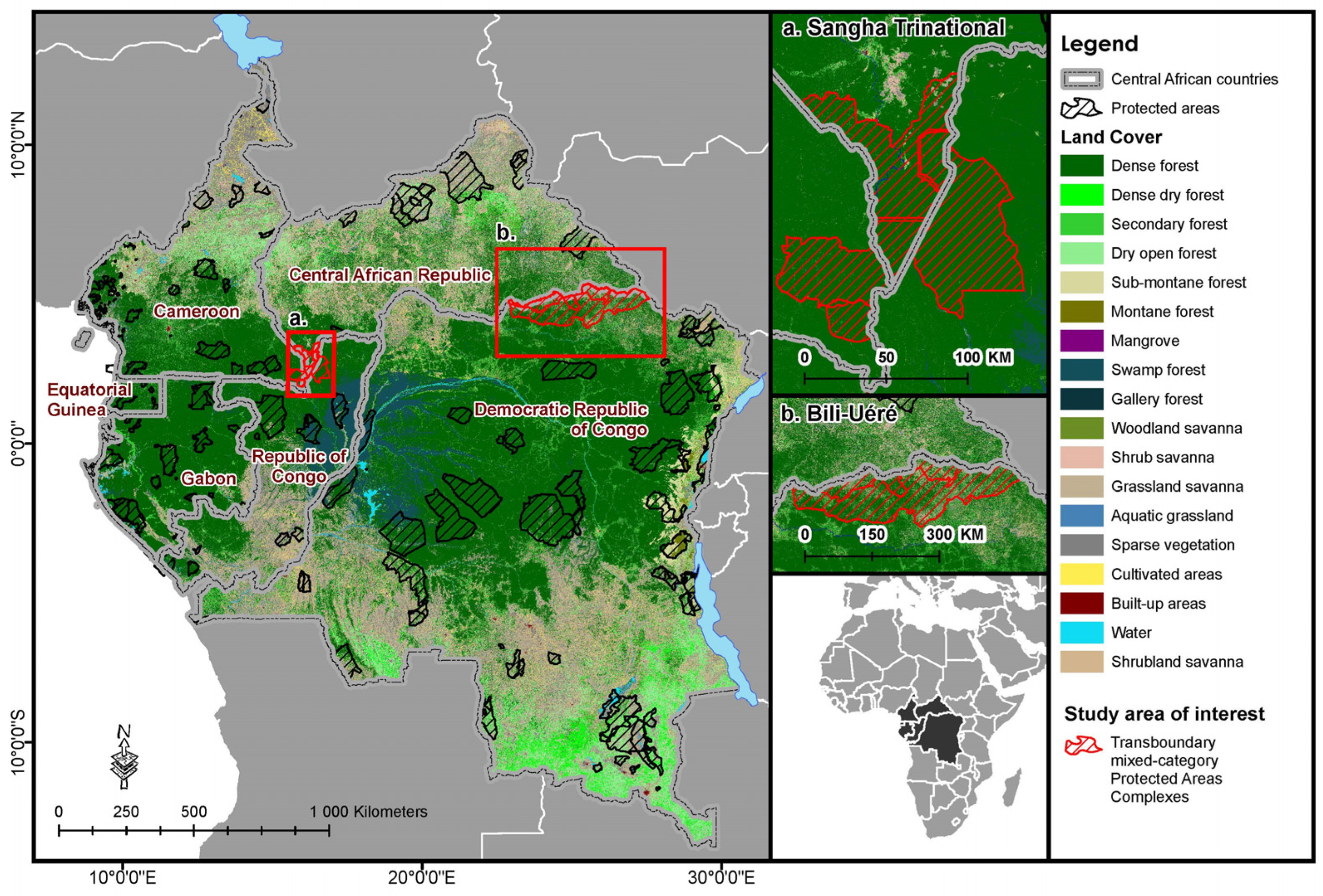
Figure 1. Land cover in the six countries of the Central African subregion included in this study (Cameroon, Central African Republic, Democratic Republic of Congo, Republic of Congo, Gabon, Equatorial Guinea). Source: Authors. Data: WDPA, 2023 [22]; CAFI, 2022 [23].
Remotesensing 16 00204 g001
Figure 2. (a) Conflict fatalities in the Central Africa subregion aggregated for 2010–2022. (b) Heatmap of overall conflict incidents in the Central Africa subregion aggregated for 2010–2022. Source: Authors. Data: ACLED, accessed 2022 [63].
Remotesensing 16 00204 g002
Figure 3. Workflow demonstrating the major procedures undertaken in this study [2].
Remotesensing 16 00204 g003
Figure 4. (a) Sangha Trinational Protected Areas Complex (STPAC) at the border of CMR, COG, and CAR, including three national parks (~705,000 ha), a forest reserve (~58,000 ha), and a special reserve (~339,000 ha). Source: Authors. Data: WDPA, 2023 [22]. (b) Bili-Uéré Protected Areas Complex (BUPAC) at the border of DRC and CAR, including both Bili-Uéré Hunting Reserve (~3.2 million ha) and Bomu Wildlife Reserve (~1.1 million ha). DRC official protected area categories are also illustrated. Source: Authors. Data: Pélissier et al., 2018 [73].
Remotesensing 16 00204 g004
Figure 5. Using the small-scale agriculture points [2] from the drivers of deforestation point layer (a), we then created the distance raster layer for small-scale agriculture for the BUPAC extent (b).
Remotesensing 16 00204 g005
Figure 6. Variable importance in random forest model used to predict increased risk to intact forest resulting from randomly generated small-scale agriculture points. All image stack variables, including small-scale agriculture and infrastructure, are the variables in the image stack for which the prediction error would increase the most if they were removed from the model.
Remotesensing 16 00204 g006
Figure 7. (a) Risk to intact forest output layer, displaying predicted increased risk resulting from randomly generated small-scale agriculture points, presenting a close-up view of (b) unprotected and (c) protected points.
Remotesensing 16 00204 g007
Figure 8. (a) Boxplots comparing mean risk values inside and outside the protected area complex boundaries. (b) Comparing distributions via kernel density estimation.
Remotesensing 16 00204 g008
Figure 9. Predicted increased deforestation by protected area category and country in transboundary system. The left includes all sites combined.
Remotesensing 16 00204 g009
Figure 10. K-means clustering of predicted increased risk to intact forests from small-scale agriculture. Light blue indicates clustering of the lowest relative levels of predicted increased risk, with dark green indicating clustering of the highest relative levels of predicted increased risk. * indicates that the maps for the two protected areas complexes are presented at different scales for the purposes of the visualization, as BUPAC is larger than STPAC.
Remotesensing 16 00204 g010
Table 2. Data layers and sources.
Data LayerSourceYearsAuthors’ Note
Direct Drivers–Validated Drivers of Deforestation
Point Layer
Shapiro et al., 2023 [2]2015–2020Derived dataset from FAO-CAFI with high-quality data for study area using recent time series
Conflict Fatalities (points)ACLED Conflict Database, 2022 [63]2015–2023Most recently available conflict data at time of analysis
Deforestation and Degradation 2015–2020 ChangeCAFI, 2022 [2,23]2015–2020Derived classification from FAO-CAFI with high-quality imagery for study area
Land Cover 2015Landsat (U.S. Geological Survey) and Sentinel 1 (European Space Agency)2015Derived land cover classification from FAO-CAFI with high-quality imagery for study area
Forest Fragmentation 2015CAFI, 2022 [2,23]; Soille & Vogt, 2009 [96]2015Derived classification from FAO-CAFI with high-quality imagery for study area
Croplands 2019Landsat (U.S. Geological Survey) and Sentinel 1 (European Space Agency)2019Most recently available agricultural classification at time of analysis
Protected AreasWDPA, 2022 [22]2022Comprehensive, up-to-date dataset available for study area at time of analysis
RoadsCAFI, 2022 [23]; Kleinschroth et al., 2019 [97]2019Comprehensive, up-to-date dataset available for study area at time of analysis
Administrative Boundaries Central AfricaFAO Global Administrative Unit Layers [98]2022Up-to-date dataset available at time of analysis
Forest Landscape Integrity IndexGrantham et al., 2020 [99]2019Comprehensive, up-to-date dataset available for study area at time of analysis
World Governance Indicators—political stability, regulatory qualityWorld Bank, accessed 2022 [100]2015–2020Comprehensive, up-to-date dataset available at time of analysis
DEMNASA DEM, accessed 2022 [101]2022Most recently available at time of analysis
Accessibility to CitiesWeiss et al., 2018 [102]2018Comprehensive global accessibility data used for comparative purposes alongside road layer
ALOS-Palsar MosaicJapanese Space Agency, JAXA; Shimada & Ohtaki, 2010 [103]2015, 2022Mosaics used as base data as part of derivation of other layers
Soil Fertility and Bulk DensityHengl et al., 2021 [104]2021Most recently available at time of analysis
Climate (monthly average, min, max temperature, and precipitation)Hijmans, et al., 2005 [105]2000Climate surfaces as base data for derivation of other layers
Burned Forest AreaGiglio et al., 2018 [106]2016–2022Derived using MODIS burned area product and the CAFI 2015 forest mask for Central Africa
Tree CoverCAFI, 2022 [23]2015Baseline tree cover for monitoring period [2]
Note: Data layers were accessed via GEE assets in the FAO project repository https://data.congo.dddafrica.info (accessed on 27 March 2022).
Table 3. Summary statistics and results of t-tests comparing zonal statistics of increased risk to intact forest from small-scale agriculture for “inside protected area” and “outside protected area” raster outputs based on a stratified random sample (n = 4000). Comparative statistics (t-values) are bolded, and interpretation is provided within the table for clarity.
BUPACMean Value aMaximum ValuePixel Count
Outside park124.667213104.8
Inside park155.870652914.1
t-value7.28 ***
Overall mean risk values were significantly higher inside park
1.91 *
Maximum risk value was significantly higher inside park
−10.21 ***
Non-zero pixel count was significantly lower for outside park, indicating possible areas of higher extremes
STPACMean valueMaximum valuePixel count
Outside park78.48402313,112
Inside park68.02431712,362
t-value−3.52 ***
Overall mean risk values were significantly lower inside park
1.93 *
Maximum risk value was significantly higher inside park, indicating pockets of higher risk despite overall lower risk inside park
−8.87 ***
Non-zero pixel count was significantly lower for outside park, indicating possible areas of higher extremes
a Mean is of average pixel value within all 1000 2 km buffer points on each side of the park boundary. * indicates p < 0.15; *** p < 0.01.
Disclaimer/Publisher’s Note: The statements, opinions and data contained in all publications are solely those of the individual author(s) and contributor(s) and not of MDPI and/or the editor(s). MDPI and/or the editor(s) disclaim responsibility for any injury to people or property resulting from any ideas, methods, instructions or products referred to in the content.