Article

Radiometric Calibration of GF5-02 Advanced Hyperspectral Imager Based on RadCalNet Baotou Site

1
Land Satellite Remote Sensing Application Center, Ministry of Natural Resources, Beijing 100844, China
2
School of Earth Sciences and Engineering, Hohai University, Nanjing 210098, China
3
School of Earth and Space Sciences, Peking University, Beijing 100871, China
*
Author to whom correspondence should be addressed.
Remote Sens. 2023, 15(9), 2233; https://doi.org/10.3390/rs15092233
Submission received: 2 March 2023 / Revised: 20 April 2023 / Accepted: 21 April 2023 / Published: 23 April 2023
(This article belongs to the Special Issue Hyperspectral Remote Sensing Data Calibration and Validation)

Abstract

:
In this study, an on-orbit radiometric calibration campaign of the GF5-02 AHSI was performed at the RadCalNet Baotou site, based on the automated observation of reflectance and atmospheric parameters of a 300 m × 300 m homogeneous desert area. The consistency of the radiometric calibration coefficients was validated both at the Dunhuang calibration site and the Baotou site. The average relative difference between the calibrated top-of-atmospheric (TOA) radiance and the predicted TOA radiance were less than 7%. The R2 of these two TOA radiances were all higher than 0.99. These results showed that the accuracy of calibration coefficients could meet the requirements of hyperspectral quantification applications. The uncertainty of GF5-02 AHSI radiometric calibration was 6.18%. This study also demonstrated that automated observation data of the Baotou site were reliable for high-frequency radiometric calibration and radiometric performance monitoring of GF5-02 AHSI.

1. Introduction

China successfully launched the GF5-02 satellite from Taiyuan Satellite Launch Center on 7 September 2021. The GF5-02 satellite, which was the successor to the GF5 satellite, was equipped with seven payloads, including a multispectral sensor and a hyperspectral imager for terrestrial Earth Observation, along with five atmospheric observation sensors. One of the most important payloads onboard the GF5-02 satellite is the hyperspectral payload for terrestrial Earth Observation—Advanced Hyperspectral Imager (AHSI), which has a swath of 60 km and more than 300 spectral bands ranging from 380 nm to 2500 nm with a spatial resolution of 30 m. The spectral resolutions of the visible near-infrared bands (VNIR, 380–1000 nm) and shortwave infrared bands (SWIR, 1000–2500 nm) are 5 and 10 nm, respectively. This would improve China’s hyperspectral observation capabilities for natural resource and environmental monitoring and provide domestic hyperspectral data for industrial applications.
The reliability of quantitative applications of hyperspectral data depends on the accuracy of the radiometric calibration. Radiometric calibration is the process of converting the imagery digital number (DN) of remote sensors into physical quantities (e.g., radiance), which is a critical preprocessing step in remote sensing applications [1]. Radiometric calibration is an essential foundation for geophysical parameter retrieval by hyperspectral remote sensing data [2]. However, even with thorough prelaunch laboratory calibration, the satellite sensor was susceptible to degradation during orbital operations caused by many factors such as vibration during launch and strong ultraviolet radiation. It was difficult to ensure the accuracy and stability of the radiometric performance of satellite sensors, as the radiometric performance of sensors gradually degrades for years, especially in the solar reflectance bands (380–2500 nm). For example, the band sensitivity of AVHRR onboard the NOAA-10 satellite decreased by as much as 42% within two years after launch. The SPOT satellite also experienced a several percent decrease in band sensitivity during its six years of operation [3]. On-orbit absolute radiometric calibration is required to evaluate and monitor the radiometric performance of satellite sensors, in order to ensure the stability and accuracy of quantitative satellite remote sensing products.
Currently, the vicarious calibration method is mainly used for the on-orbit calibration of satellite sensors. The reflectance-based method proposed by Slater has become the most common method due to its high accuracy and ease of implementation [4]. This reflectance-based method had been successfully applied on China’s Fengyun, Huanjing, Ziyuan, and Gaofen series satellites [5,6,7,8,9]. Since the GF5-02 AHSI lacked a stable onboard calibration device, reflectance-based vicarious calibration was the optimum way to evaluate the on-orbit radiometric performance of GF5-02 AHSI.
The on-orbit radiometric calibration campaign of the GF5-02 AHSI was performed in this study using the synchronous measurement data from the RadCalNet Baotou site, and the calibration coefficients were determined. The accuracy of the calibration coefficients was validated at China’s Dunhuang calibration site and the Baotou site. Finally, the calibration uncertainty and accuracy were analyzed and discussed in this paper.

2. Materials and Methods

2.1. GF5-02 Satellite and AHSI

China successfully launched the GF5-02 hyperspectral observation satellite from the Taiyuan Satellite Launch Center on 7 September 2021. The GF5-02 satellite is in a sun-synchronous orbit with an altitude of 705 km. The weight of the whole satellite is about 2690 kg, and its designed lifetime is 8 years. The GF5-02 satellite has a repeat cycle time of 51 days and the equator crossing time is 10:35 a.m. (local time). The key technical parameters of the GF5-02 satellite and AHSI were shown in Table 1.
The Advanced Hyperspectral Imager (Figure 1) equipped on the GF5-02 satellite reached an advanced level in the world. This GF5-02 AHSI was a push broom hyperspectral imager, which has a swath of 60 km with a spatial resolution of 30 m, covering the range from 380 nm to 1000 nm (VNIR) with 150 bands and then from 1000 nm to 2500 nm (SWIR) with 180 bands.
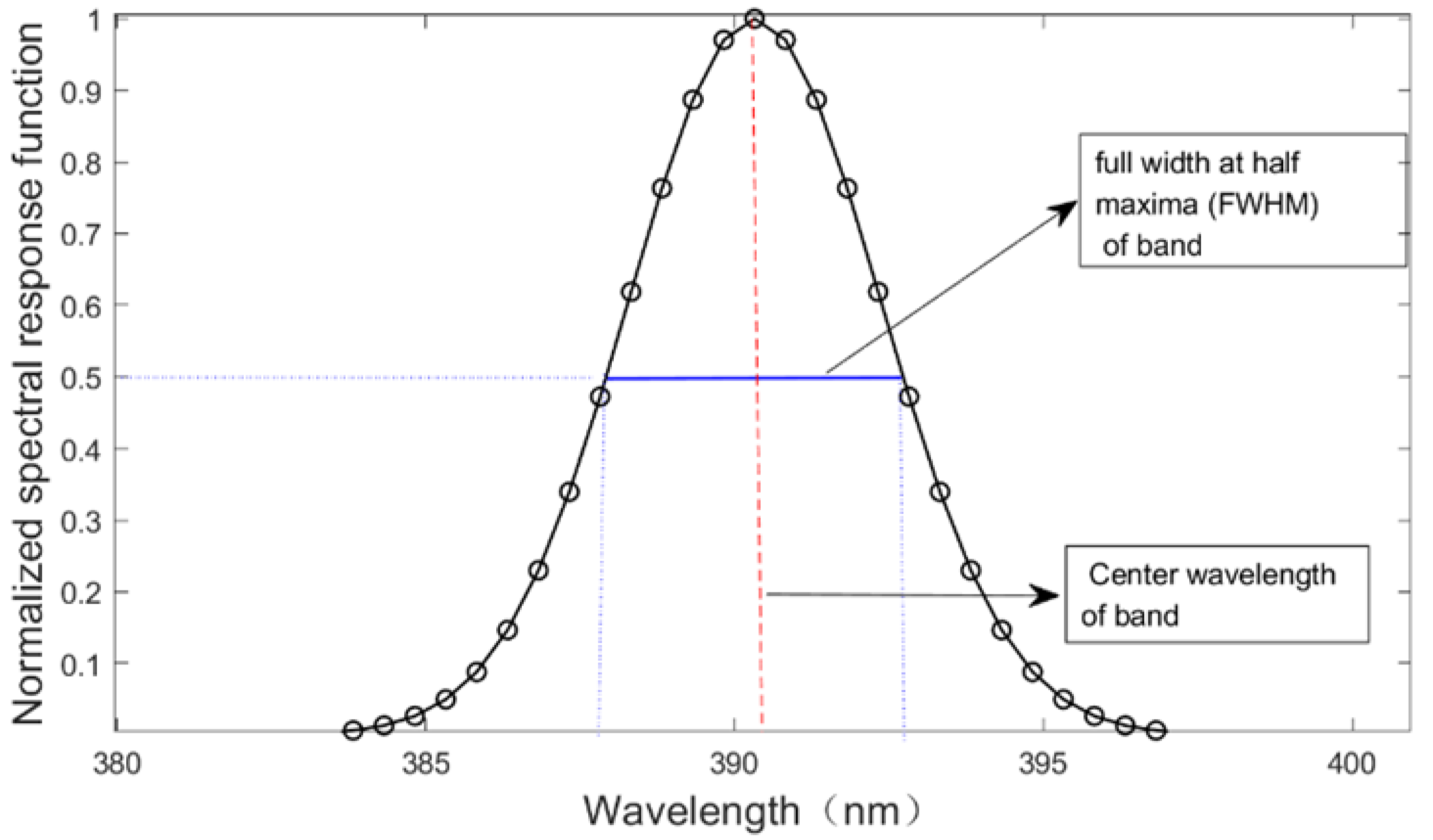
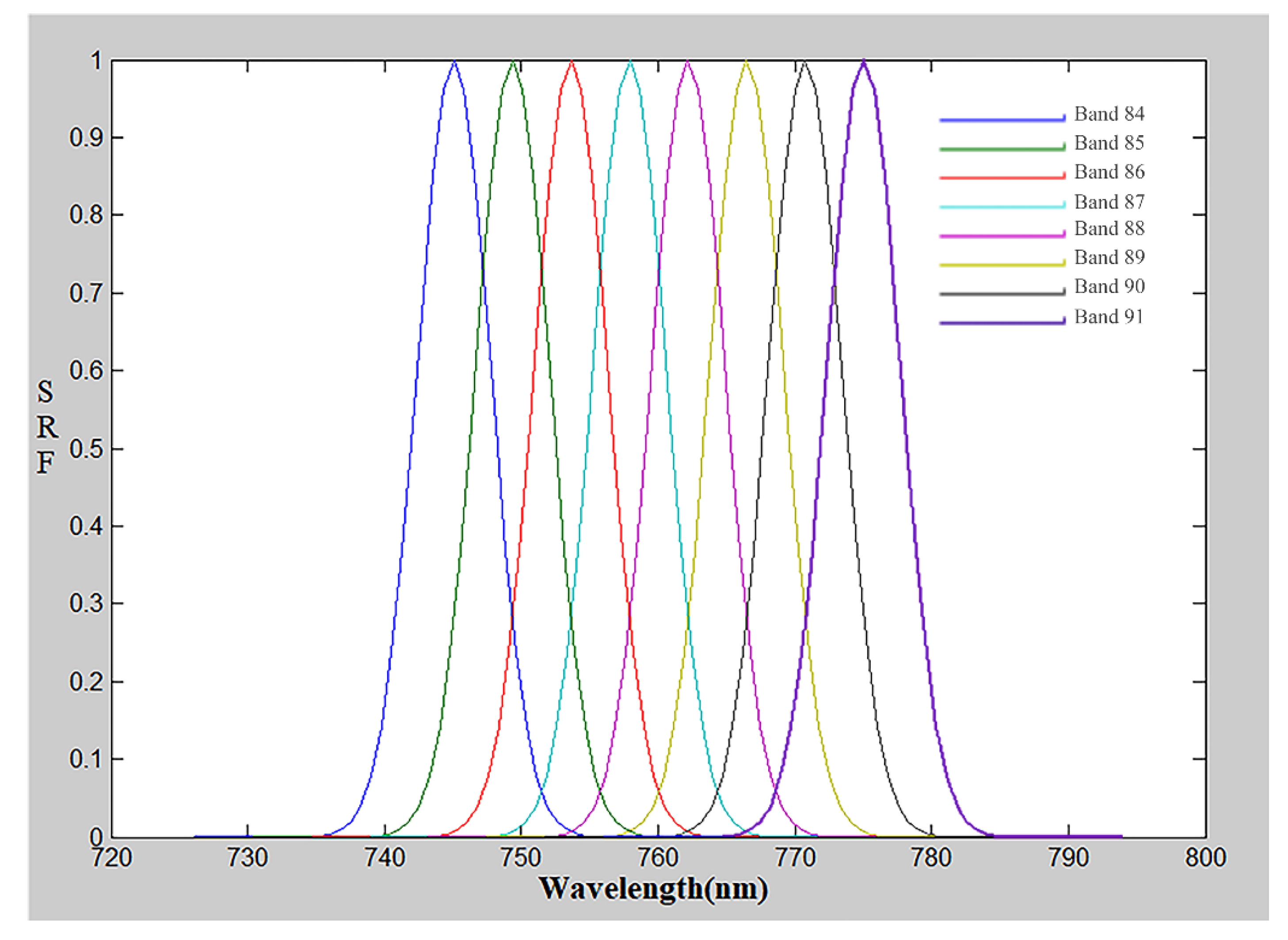
The spectral resolution in VNIR bands is 5 nm and 10 nm in SWIR bands. Figure 2 shows the spectral response function (SRF) of GF5-02 AHSI Band 1 from laboratory spectral calibration, where the spectral parameters of this band are also obtained. The center wavelength is 390.32 nm and the full width at half maxima (FWHM) is 4.81 nm. Figure 3 shows the spectral response function of GF5-02 AHSI Band 84 to Band 91, where the center wavelength ranges from 745 to 775 nm).

2.2. Reflectance-Based Vicarious Calibration Method

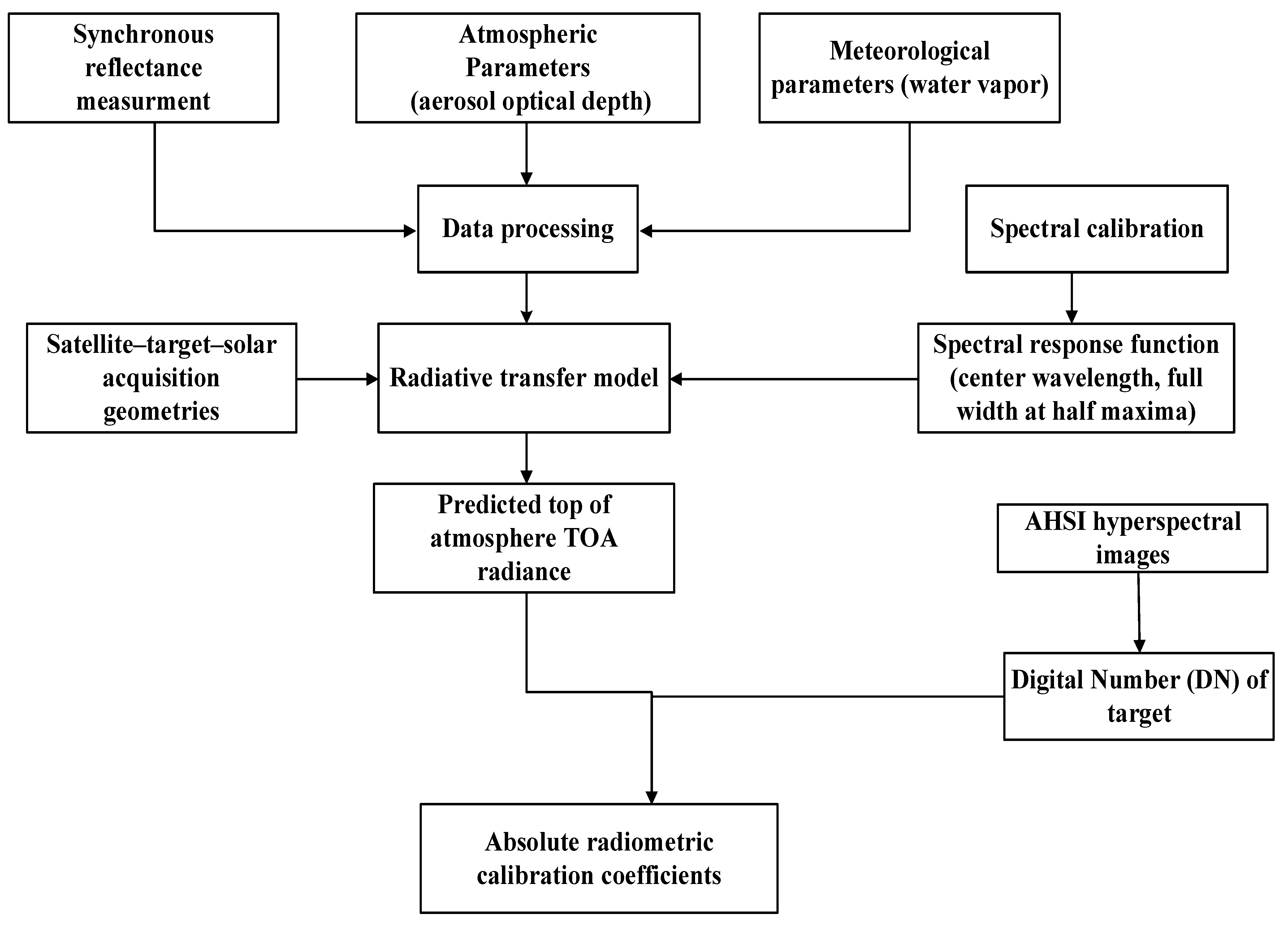
A reflectance-based absolute radiometric calibration method for GF5-02 AHSI was employed in this study. The spectral reflectance data of the homogeneous target were collected synchronously when the GF5-02 satellite passes over the radiometric calibration site. The atmospheric parameters would also be measured synchronously at the satellite overpass time. The spectral reflectance measurements and atmospheric parameters such as aerosol optical depth (AOD) and water vapor (WV) were taken as input into the radiative transfer model to predict top-of-atmospheric (TOA) radiance. The SRF of each band of AHSI and the solar-target-satellite acquisition geometry parameters were also essential for the radiative transfer simulation calculation. The digital value (DN) of the homogeneous target was extracted from satellite imagery. Finally, the absolute radiometric calibration coefficient was determined, and the uncertainty of radiometric calibration would be analyzed [10]. The flow of the on-orbit reflectance-based radiometric calibration method is shown in Figure 4.
In order to predict the TOA radiance (apparent radiance) of GF5-02 AHSI, the spectral reflectance, the SRF, atmospheric parameters, and solar-target-satellite geometric parameters were input into the radiative transfer model MODTRAN 6.0 [11]. The radiative transfer model would use these inputs to calculate the TOA radiance for each band for GF5-02 AHSI.
L o b s = L p a t h + μ s E 0 π ρ 1 ρ S T ( θ s ) T ( θ v )
where L o b s is the TOA radiance of the AHSI, L p a t h is the atmospheric-pass radiation, E 0 is the solar irradiance at the top of the atmosphere, ρ is the surface reflectance, S is the downward albedo of the atmosphere, T ( θ s ) is the total transmittance of the path from the sun to the surface, and T ( θ v ) is the total transmittance from the surface to the satellite. θ s is the solar zenith angle, θ v is the zenith angle of sensor observation, and μ s = cos θ s .
The SRF of each band of the GF5-02 ASHI is determined with the spectral calibration parameters as per the following Equation (2):
S R F ( λ i , F W H M i ) = exp λ λ ( i ) F W H M ( i ) / 2 ln 2 2
where S R F ( λ i , F W H M i ) is the SRF of the AHSI i-band, and λ ( i ) and F W H M ( i ) are spectral calibration parameters: center wavelength and full width at half maxima (FWHM), respectively.
The TOA Radiance of each band L o b s ( i ) could be predicted by convolving the TOA radiance of the GF5-02 AHSI with the spectral response function of each band.
L o b s ( i ) = L o b s S R F ( λ i , F W H M i ) S R F ( λ i , F W H M i )
Based on the least squares method, the radiometric calibration coefficient would be determined by the following Equation (4):
L o b s ( i ) = D N ( i ) × G a i n ( i )
in which, D N ( i ) is the digital value of target extracted from GF5-02 AHSI i-band and G a i n ( i ) is the radiometric calibration coefficient of the i-band.

2.3. RadCalNet Baotou Site

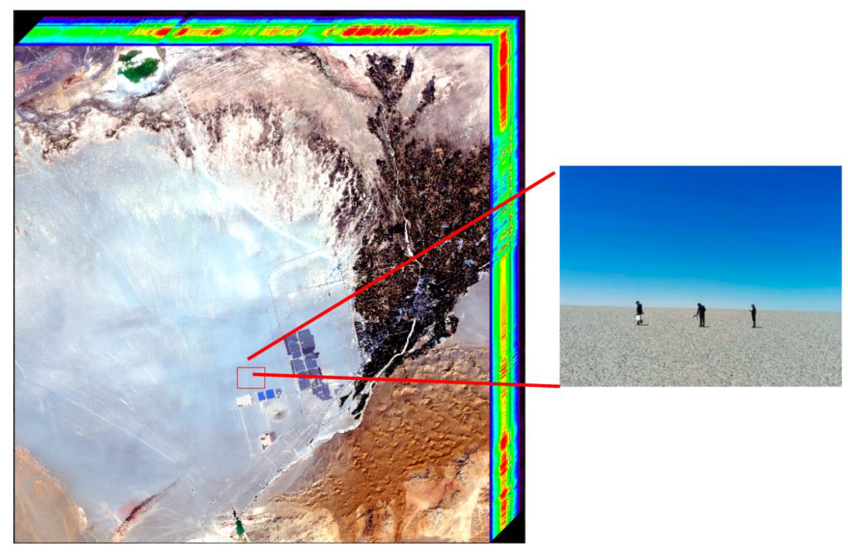
RadCalNet was an international calibration network proposed by the Committee on Earth Observation Satellites (CEOS) Working Group on Calibration and Validation (WGCV) and the Infrared Visible Optical Sensors (IVOS) in 2014 [12,13]. There are four international calibration sites of RadCalNet: the Railroad Valley Playa Site (RVUS) in the U.S.A., the Gobabeb site (GONA) in Namibia, the La Crau site (LCFR) in France, and the Baotou site (BTCN) in China. The BTCN is currently operated by the Chinese Academy of Science (CAS), which is located in Inner Mongolia Province, China. A 300 m × 300 m homogeneous sand was established for automated radiometric calibration and validation of satellite sensors in October 2015 [14]. An automatic observation system was established in the center of the homogeneous sand at the RadCalNet Baotou calibration site. The Baotou site was also equipped with an automatic spectrometer, a CIMEL CE318 sunphotometer, and an automatic weather station. Figure 5 shows the homogeneous desert area and automatic observation system at the Baotou site. The spectral reflectance of the homogeneous sand was collected with the automatic observation system. In addition, the AOD and atmospheric column water vapor (CWV) were retrieved by CIMEL software from the CE318 sunphotometer observed data at the site.

3. Results

3.1. Vicarious Radiometric Calibration Campaign at the RadCalNet Baotou Site

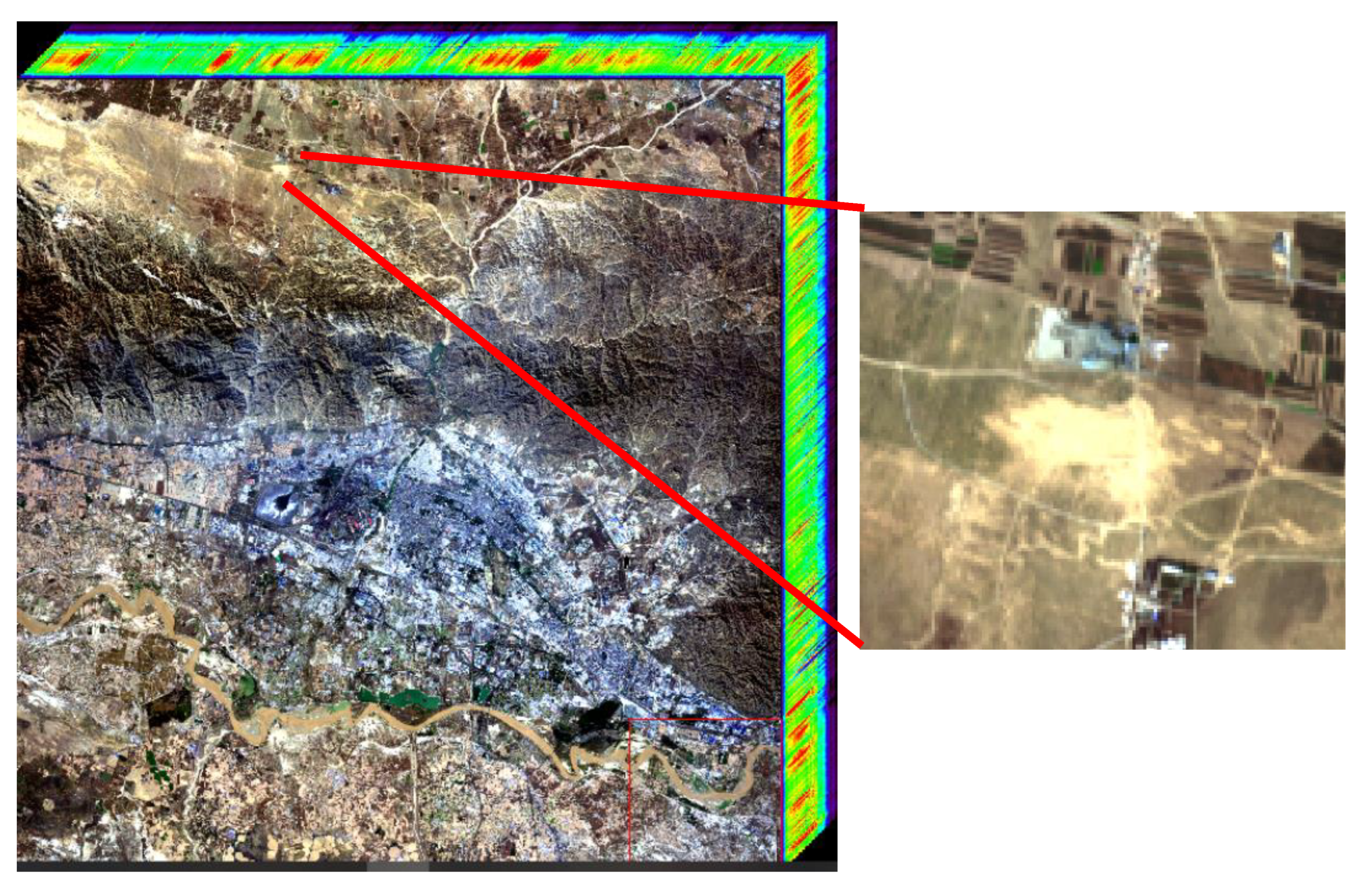
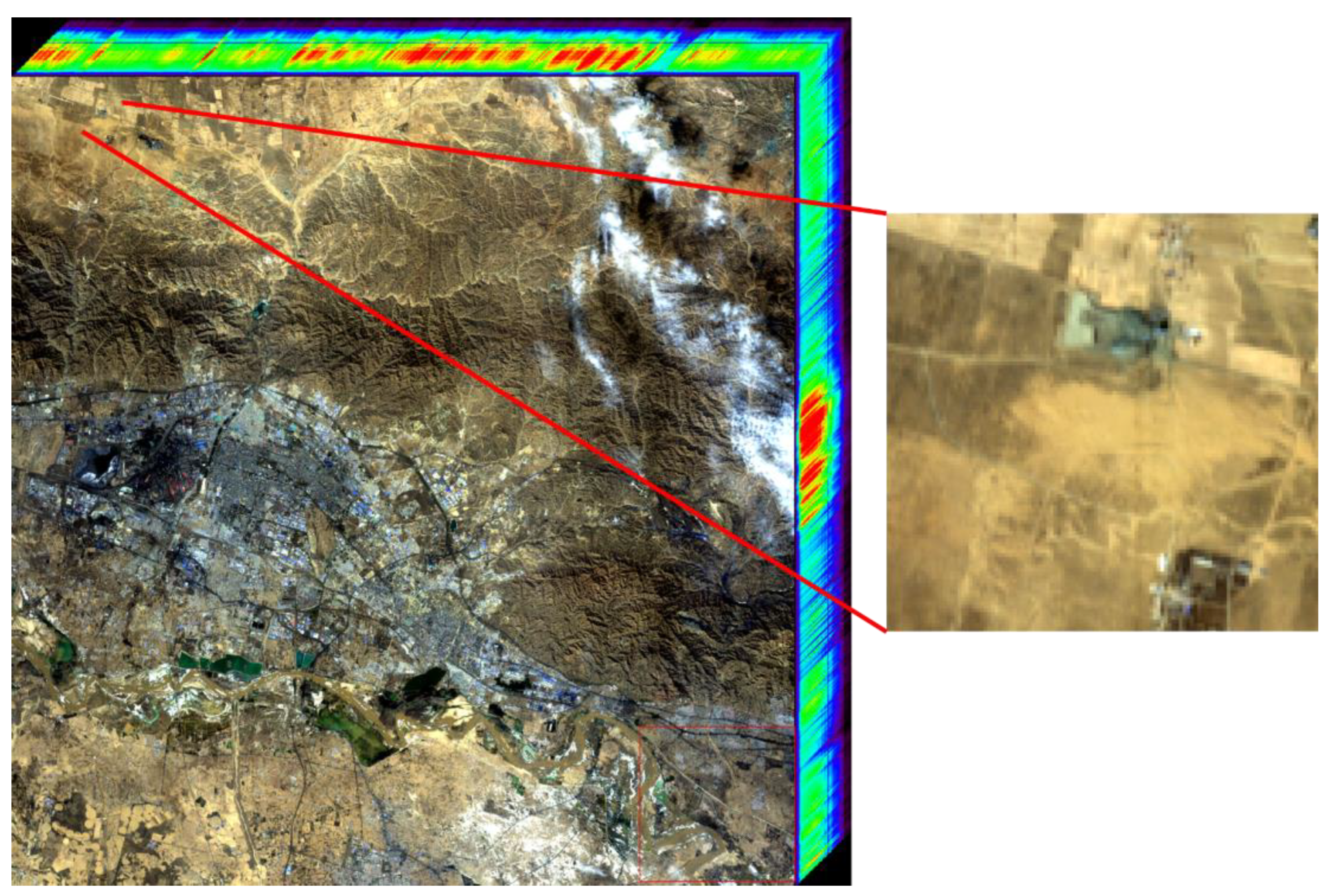
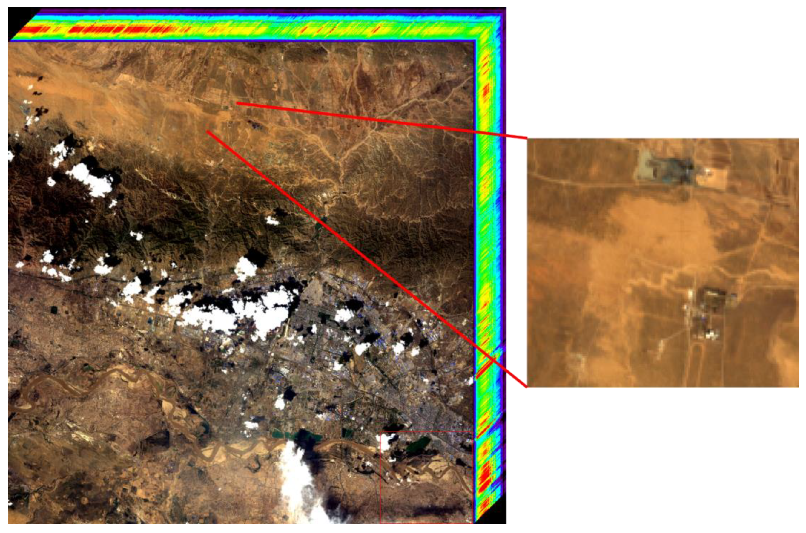
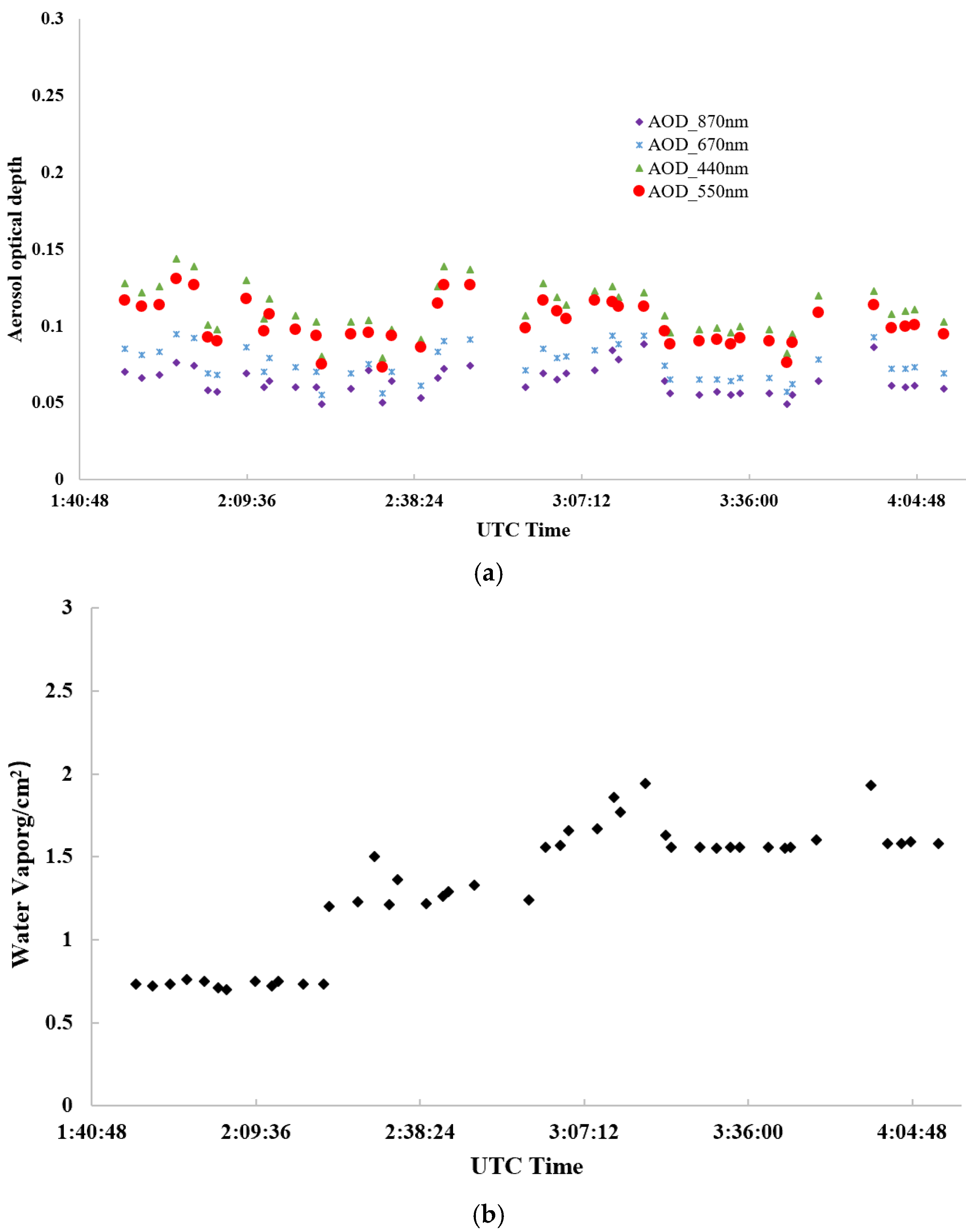
The GF5-02 satellite was successfully launched on 7 September 2021. The satellite is officially operating on 20 May 2022 after eight months of on-orbit testing (OBT). The GF5-02 satellite acquired AHSI hyperspectral imagery of the RadCalNet Baotou site on 2 April, 23 May, 13 July, and 2 September 2022. Figure 6, Figure 7 and Figure 8 show the AHSI hyperspectral imagery of the RadCalNet Baotou site. RadCalNet automated measurements of surface reflectance were acquired every 2 min between 09:00 a.m. and 15:00 p.m. local time [13]. The automated reflectance measurements at wavelengths between 350 nm and 2500 nm were collected with a 1 nm spectral interval. The atmospheric parameter measurements such as AOD at 550 nm, CWV, and columnar ozone were also collected every 3 min automatically. Figure 9 shows the mean reflectance measurements of sand at the GF5-02 satellite overpass on RadCalNet Baotou site.
Table 2 shows the solar-target-satellite acquisition geometric parameters and atmospheric parameters of four GF5-02 satellite overpasses. The AOD @550 nm at the satellite overpass time on 23 May 2022 was less than 0.1, and this value reached 0.2165 on 13 July 2022. In this study, the automated measurements at the RadCalNet Baotou site on 2 April, 23 May, and 2 September were used for radiometric calibration and the data collected on 13 July were used for validation.
As shown in Figure 10, the multi-angle bidirectional reflectance distribution function (BRDF) effect of the homogeneous sand at the RadCalNet Baotou site was measured by the multi-angle BRDF measurement instrument [7]. The spectral reflectance measurements of the target could be corrected by the BRDF measurement.
ρ ( θ i , φ i , θ v , φ v , λ ) = ρ ( θ i , φ i , θ v , φ v , λ ) B R D F ( θ i , φ i , θ v , φ v , λ )
where θ i , φ i , θ v , φ v were the solar zenith angle, solar azimuth angle, viewing zenith angle and viewing azimuth angle, respectively [15]. B R D F ( θ i , φ i , θ v , φ v , λ ) was the BRDF correction factor which could be calculated from multi-angle BRDF measurement. ρ ( θ i , φ i , θ v , φ v , λ ) was the reflectance measurement and ρ ( θ i , φ i , θ v , φ v , λ ) was the BRDF-corrected spectral reflectance.
Figure 11 shows the AOD and CWV measurements during the calibration campaign, the measurements on 23 May were taken as an example.

3.2. Calibration Results

In this study, the synchronous measurements on 2 April, 23 May, and 2 September were used for the determination of the radiometric calibration coefficients. The predicted TOA radiance of GF5-02 AHSI was obtained from Modtran 6.0 with these synchronous measurements, as shown in Figure 12. The measurements of AOD@550 nm of this site were less than 0.15 during the calibration campaigns. The low aerosol loading could decrease the error in the calculation of the radiative transfer model by choosing the aerosol type.
The reflectance of this sand was more than 0.3 from 650 nm to 2500 nm, which could be considered as high-reflectance ground targets. This homogeneous sand covered 10 × 10 30-m pixels for GF5-02 AHSI. The mean DNs of the homogenous desert were extracted from GF5-02 AHSI imagery, as shown in Figure 13. It was worth noting that the DNs of atmospheric absorption bands (1350–1425 nm and 1800–1940 nm) were set as zero in the GF5-02 AHSI imagery.
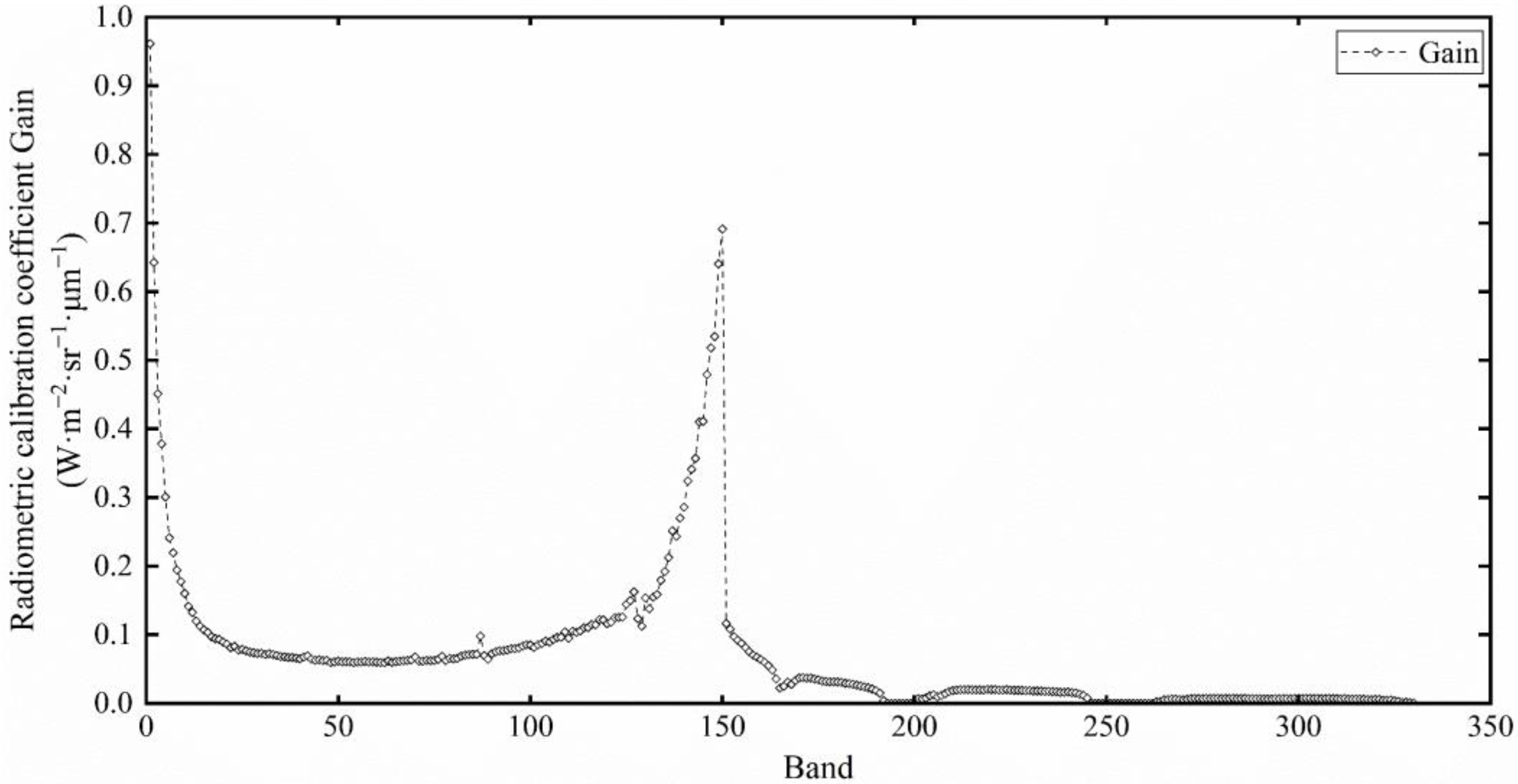
The absolute radiometric calibration coefficients of GF5-02 AHSI were determined by the least squares method using the DNs and TOA radiance, as Figure 14 shows. The Gains of those atmospheric absorption bands were 0. The uncertainty analysis and validation would be provided in the following section.

3.3. Baotou Validation Results

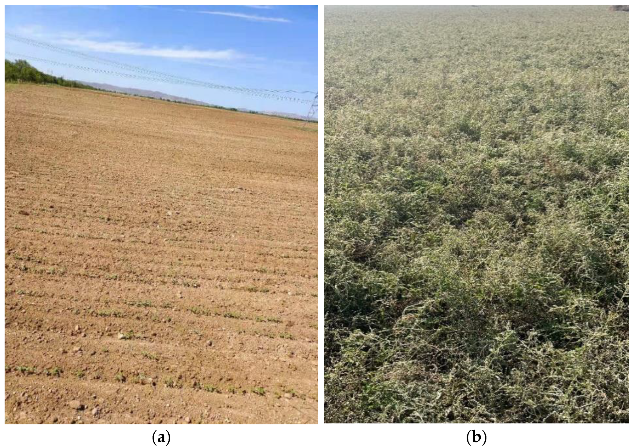
The synchronous measurements at the RadCalNet Baotou site on 13 July were used for validation of the calibration coefficient. In addition to the automatic observation data, bare soil (200 m × 200 m) and grassland (200 m × 200 m) at the Baotou site were also selected for validation, as shown in Figure 15. The synchronous measurements of reflectance of these two homogeneous ground surface types were collected by an SVC HR-1024i spectrometer. The spectral reflectance measurements of sand, bare soil, and grassland are depicted in Figure 16.
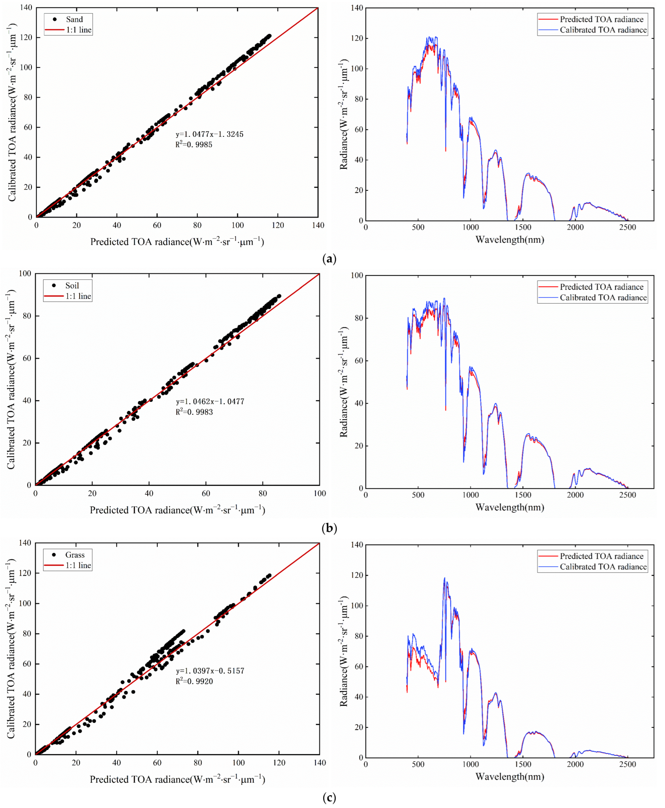
The predicted TOA radiance L p r e d i c t e d A H S I was calculated by the radiative transfer model with reflectance and atmospheric parameters. The calibrated TOA radiance L C a l A H S I was calculated based on the AHSI imagery with the calibration coefficient and was compared with the TOA predicted radiance L p r e d i c t e d A H S I . The average relative difference (ARD) between these two TOA radiances could be used to validate the calibration coefficient.
A R D = m e a n ( L C a l A H S I L p r e d i c t e d A H S I L p r e d i c t e d A H S I ) × 100 %
Figure 17 shows the comparison between the calibrated TOA radiance and predicted TOA radiance obtained at the RadCalNet Baotou site on 13 July 2022. All the R2 were higher than 0.99, which meant that the TOA radiance based on the vicarious radiometric calibration coefficient and the TOA radiance predicted from the radiative transfer model were in good agreement. The R2 of the homogeneous sand is 0.9985, which was the highest. The R2 of grassland is 0.992, which was the lowest. The calibrated TOA radiance was highly consistent with the predicted TOA radiance.
Table 3 shows the average relative difference between these two TOA radiances. All the ARDs were less than 7% without atmospheric absorption bands. The ARD between the calibrated TOA radiance and the predicted TOA radiance of homogeneous sand at the Baotou site was 5.78%, which was the lowest. A lower ARD also represented that the calibrated TOA radiance agreed better with the predicted TOA radiance, which demonstrated that the accuracy of radiometric calibration was higher.

3.4. Dunhuang Validation Results

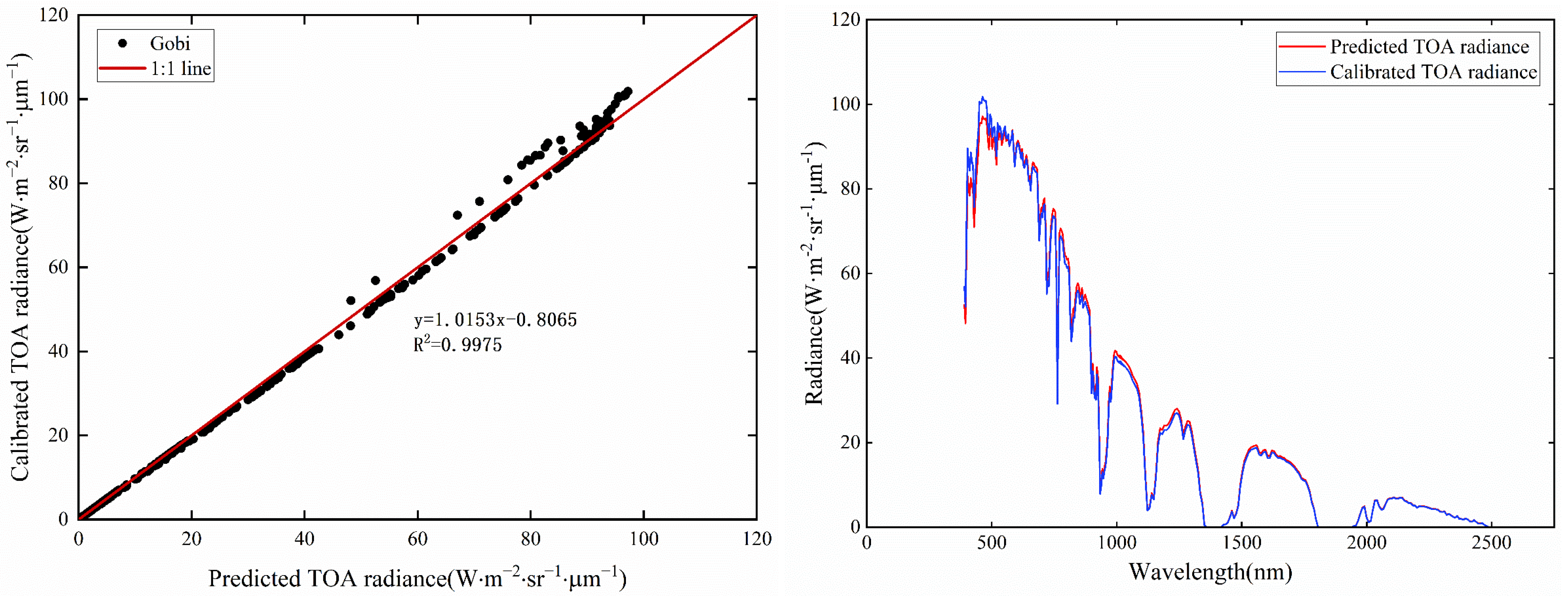
In order to evaluate the radiometric performance of GF5-02 AHSI, the Gobi Desert of Dunhuang calibration site was selected as a reference to validate the calibration coefficients. As China’s national radiometric calibration site (CRCS), the Dunhuang calibration site was used for the on-orbit vicarious radiometric calibration of China’s FengYun and GaoFen satellites for decades. The reflectance of the Gobi Desert at Dunhuang calibration site was stable with an annual variation of less than 2% [16]. Figure 18 shows the homogeneous Gobi Desert at Dunhuang calibration site of GF5-02 AHSI imagery on 29 September 2022. The core region of the homogeneous Gobi Desert was about 1000 m × 1000 m, which covered more than 30×30 pixels of GF5-02 AHSI. The selected ROI was 10 × 10 pixels. A total of 100 points of spectral reflectance were measured synchronously at the GF5-02 satellite overpass time. The atmospheric parameters at the Dunhuang site were measured by a Cimel CE318 sun photometer. Daily AOD at 550 nm varied from 0.08 to 0.20 during the campaigns at the Dunhuang test site, and the synchronous AOD measurements at GF5-02 satellite overpass time were less than 0.12. Table 4 gives the solar-target-satellite acquisition geometric parameters and atmospheric parameters of the GF5-02 satellite overpass.
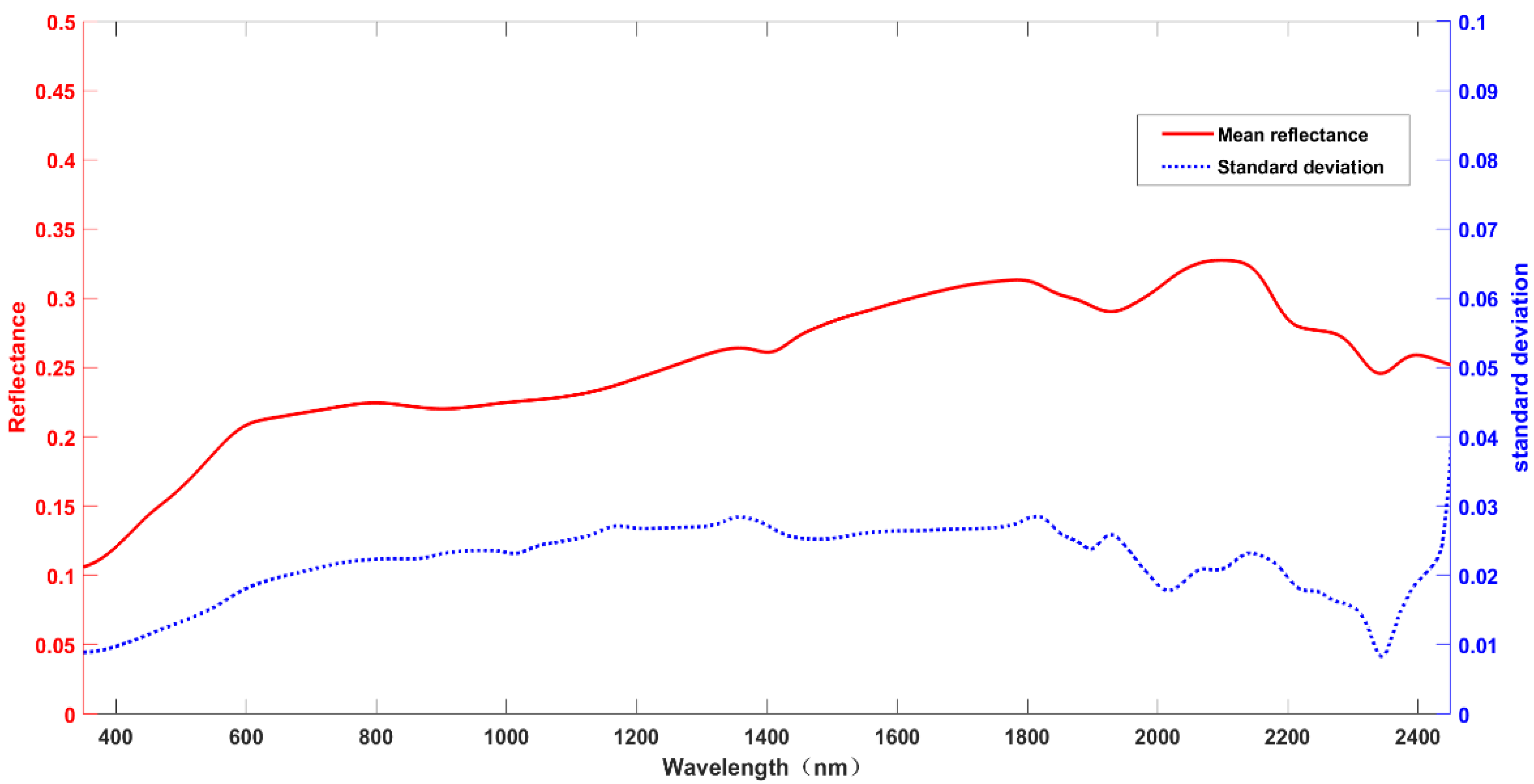
Figure 19 demonstrated the stability and homogeneity criteria of the Gobi Desert at Dunhuang Calibration site. The standard deviation of the 100 spectral reflectance measurements was less than 3%. It was clear that the comparison results of the Dunhuang site were in good agreement with the TOA radiance based on the vicarious radiometric calibration coefficient and the TOA radiance predicted from the radiative transfer model, as shown in Figure 18. Figure 20 shows the comparison between the calibrated TOA radiance and pre-dicted TOA radiance obtained at the Dunhuang site on 29 September 2022. All the R2 were higher than 0.997, which meant that the TOA radiance based on the vicarious radiometric calibration coefficient and the TOA radiance predicted from the radiative transfer model were in good agreement. The ARD of the Gobi Desert at Dunhuang site was 5.46%, which was lower than those of surface types at the Baotou site. The R2 of the Gobi Desert was also the highest, which showed the reliability of the calibration method. These comparison results of the Baotou and Dunhuang sites also indicated that GF5-02 AHSI had a good on-orbit radiometric performance.

4. Discussion

The on-orbit absolute radiometric calibration campaign of GF5-02 satellite AHSI based on the reflectance-based method was described in this paper. The total uncertainty of this absolute radiometric calibration included various sources of uncertainty: reflectance measurements, atmospheric parameter measurements, and the radiative transfer model.
(1)
The uncertainty from the spectral reflectance measurement mainly included the calibration accuracy of the reference panel and the measurement error. In this calibration campaign, the calibration uncertainty of the reference panel was approximately 2%, the uncertainty caused by the spectral measurement of the targets was about 1%, and the bi-directional reflectance distribution function (BRDF) correction uncertainty of targets was approximately 2%.
(2)
The atmospheric aerosol optical depth was determined with an uncertainty of about 2% using a rigorously calibrated CE318 sunphotometer, and the uncertainty in retrieving the physical properties of atmospheric aerosol particles from the CIMEL Software was about 1%. The absorption and transmittance of the atmosphere in the visible and near-infrared bands (380–2500 nm) are primarily influenced by typical absorbing gases such as oxygen and ozone. The uncertainty of choosing an acceptable atmospheric aerosol type was about 2%. The uncertainty of aerosol parameters in radiative transfer calculation was less than 3%, with the microphysical properties of the atmospheric aerosol considered [17].
(3)
The uncertainty of the MODTRAN 6.0 model was less than 2%, and the uncertainty caused by the solar-target-satellite geometric parameters was less than 0.5%.
Currently, the uncertainty propagation law method proposed in the Guide to the Expression of Uncertainty in Measurement (GUM) was mainly used to evaluate the uncertainty of satellite radiation calibrations. Total uncertainty was defined as the mean square sum of the individual measurement error components in this GUM method (BIPM et al., 2011). The following equation was used to calculate the total uncertainty in this study:
δ ¯ = δ p a n e l 2 + δ r e f 2 + δ b r d f 2 + δ A O D 2 + δ A T 2 + δ O z o n e 2 + δ H 2 O 2 + δ Z e n i t h 2 + δ M o d 2
According to the above analysis, the total uncertainty of GF5-02 AHSI radiometric calibration was 6.18%, as shown in Table 5.

5. Conclusions

In this study, the automated observation of atmospheric parameters and spectral reflectance at the RadCalNet Baotou site was utilized for the on-orbit radiometric calibration of the GF5-02 AHSI. The reliability of the reflectance-based method with these synchronous measurement data was validated at two different sites. Several different surface types (sand, soil, grass, and Gobi Desert) were selected for validation of radiometric calibration at the Baotou and Dunhuang sites. The ARD between the calibrated TOA radiance and the predicted TOA radiance of several different targets were all less than 7%. The R2 of these two TOA radiances were all higher than 0.99. These results showed that the accuracy of calibration coefficients could meet the requirements of hyperspectral quantification applications. The uncertainty of GF5-02 AHSI radiometric calibration was 6.18%. GF5-02 AHSI could obtain imagery of the RadCalNet Baotou site once every 51 days. The reflectance and atmospheric parameters of the homogeneous desert were collected automatically every day. The on-orbit radiometric calibration coefficients of GF5-AHSI could be updated more than four times in one year, and the on-orbit radiometric performance could be monitored reliably and efficiently based on the RadCalNet Baotou site.

Author Contributions

H.T. developed the research plan and supervised the work, C.X., K.S., T.W. and Q.L. participated in the literature review, method selection, data acquisition, and discussions. All authors have read and agreed to the published version of the manuscript.

Funding

This work was supported by the National Key R&D Program of China, 2022YFB3903200, 2022YFB3903201, 2022YFB3903000, 2022YFB3903005.

Data Availability Statement

Not applicable.

Conflicts of Interest

The authors declare no conflict of interest.

References

  1. Dinguirard, M.; Slater, P.N. Calibration of Space-Multispectral Imaging Sensors: A Review. Remote Sens. Environ. 1999, 68, 194–205. [Google Scholar] [CrossRef]
  2. Biggar, S.F.; Thome, K.J.; Wisniewski, W. Vicarious radiometric calibration of EO-1 sensors by reference to high-reflectance ground targets. IEEE Trans. Geosci. Remote Sens. 2003, 41, 1174–1179. [Google Scholar] [CrossRef]
  3. Biggar, S.F.; Dinguirard, M.C.; Gellman, G.I.; Henry, P.; Jackson, R.D.; Moran, M.S.; Slater, P.N. Radiometric Calibration of SPOT 2 HRV-a Comparison of Three Methods. Proceeding SPIE 1991, 1493, 155–162. [Google Scholar]
  4. Thome, K.J. Absolute Radiometric Calibration of Landsat 7 ETM+ Using the Reflectance-Based Method. Remote Sens. Environ. 2001, 78, 27–38. [Google Scholar] [CrossRef]
  5. Gao, H.L.; Gu, X.F.; Yu, T. The Research Overview on Visible and Near-infrared Channels Radiometric Calibration of Space-borne Optical Remote Sensors. Remote Sens. Inf. 2010, 4, 12. [Google Scholar]
  6. Hu, X.; Liu, J.; Sun, L.; Rong, Z.; Li, Y.; Zhang, Y.; Zheng, Z.; Wu, R.; Zhang, L.; Gu, X. Characterization of CRCS Dunhuang test site and vicarious calibration utilization for Fengyun (FY) series sensors. Can. J. Remote Sens. 2010, 36, 566–582. [Google Scholar] [CrossRef]
  7. Tang, H.; Xie, J.; Tang, X.; Chen, W.; Li, Q. On-Orbit Radiometric Performance of GF-7 Satellite Multispectral Imagery. Remote Sens. 2022, 14, 886. [Google Scholar] [CrossRef]
  8. Tang, H.; Xie, J.; Tang, X.; Chen, W.; Li, Q. On-Orbit Absolute Radiometric Calibration and Validation of ZY3-02 Satellite Multispectral Sensor. Sensors 2022, 22, 2066. [Google Scholar] [CrossRef] [PubMed]
  9. Chen, W.; Yan, L.; Li, Z.; Jing, X.; Duan, Y.; Xiong, X. In-flight absolute calibration of an airborne wide-view multispectral imager using a reflectance-based method and its validation. Int. J. Remote Sens. 2013, 34, 1995–2005. [Google Scholar] [CrossRef]
  10. Czapla-Myers, J.; McCorkel, J.; Anderson, N.; Thome, K.; Biggar, S.; Helder, D.; Aaron, D.; Leigh, L.; Mishra, N. The ground-based absolute radiometric calibration of Landsat 8 OLI. Remote Sens. 2015, 7, 600–626. [Google Scholar] [CrossRef]
  11. Czapla-Myers, J.; Ong, L.; Thome, K.; McCorkel, J. Validation of EO-1 Hyperion and Advanced Land Imager Using the Radiometric Calibration Test Site at Railroad Valley. IEEE J. Sel. Top. Appl. Earth Obs. Remote Sens. 2015, 9, 816–826. [Google Scholar] [CrossRef]
  12. Czapla-Myers, J.S.; Thome, K.J.; Leisso, N.P. Radiometric calibration of earth-observing sensors using an automated test site at Railroad Valley. Can. J. Remote Sens. 2010, 36, 474–487. [Google Scholar] [CrossRef]
  13. Bouvet, M.; Thome, K.; Berthelot, B.; Bialek, A.; Czapla-Myers, J.; Fox, N.P.; Goryl, P.; Henry, P.; Ma, L.; Marcq, S.; et al. RadCalNet: A Radiometric Calibration Network for Earth Observing Imagers Operating in the Visible to Shortwave Infrared Spectral Range. Remote Sens. 2019, 11, 2401. [Google Scholar] [CrossRef]
  14. Li, C.R.; Ma, L.L.; Tang, L.L.; Gao, C.X.; Qian, Y.G.; Wang, N.; Wang, X.H. A comprehensive calibration site for high resolution remote sensors dedicated to quantitative remote sensing and its applications. Natl. Remote Sens. Bull. 2021, 25, 198–219. [Google Scholar]
  15. Xiong, X.; Angal, A.; Twedt, K.A.; Chen, H.; Link, D.; Geng, X.; Aldoretta, E.; Mu, Q. MODIS reflective solar bands on-orbit calibration and performance. IEEE Trans. Geosci. Remote Sens. 2019, 57, 6355–6371. [Google Scholar] [CrossRef]
  16. Zhang, H.; Zhang, B.; Chen, Z.; Huang, Z. Vicarious Radiometric Calibration of the Hyperspectral Imaging Microsatellites SPARK-01 and-02 over Dunhuang, China. Remote Sens. 2018, 10, 120. [Google Scholar] [CrossRef]
  17. Biggar, S.F.; Slater, P.N.; Gellman, D.I. Uncertainties in the in-flight calibration of sensors with reference to measured ground sites in the 0.4–1.1 μm range. Remote Sens. Environ. 1994, 48, 245–252. [Google Scholar] [CrossRef]
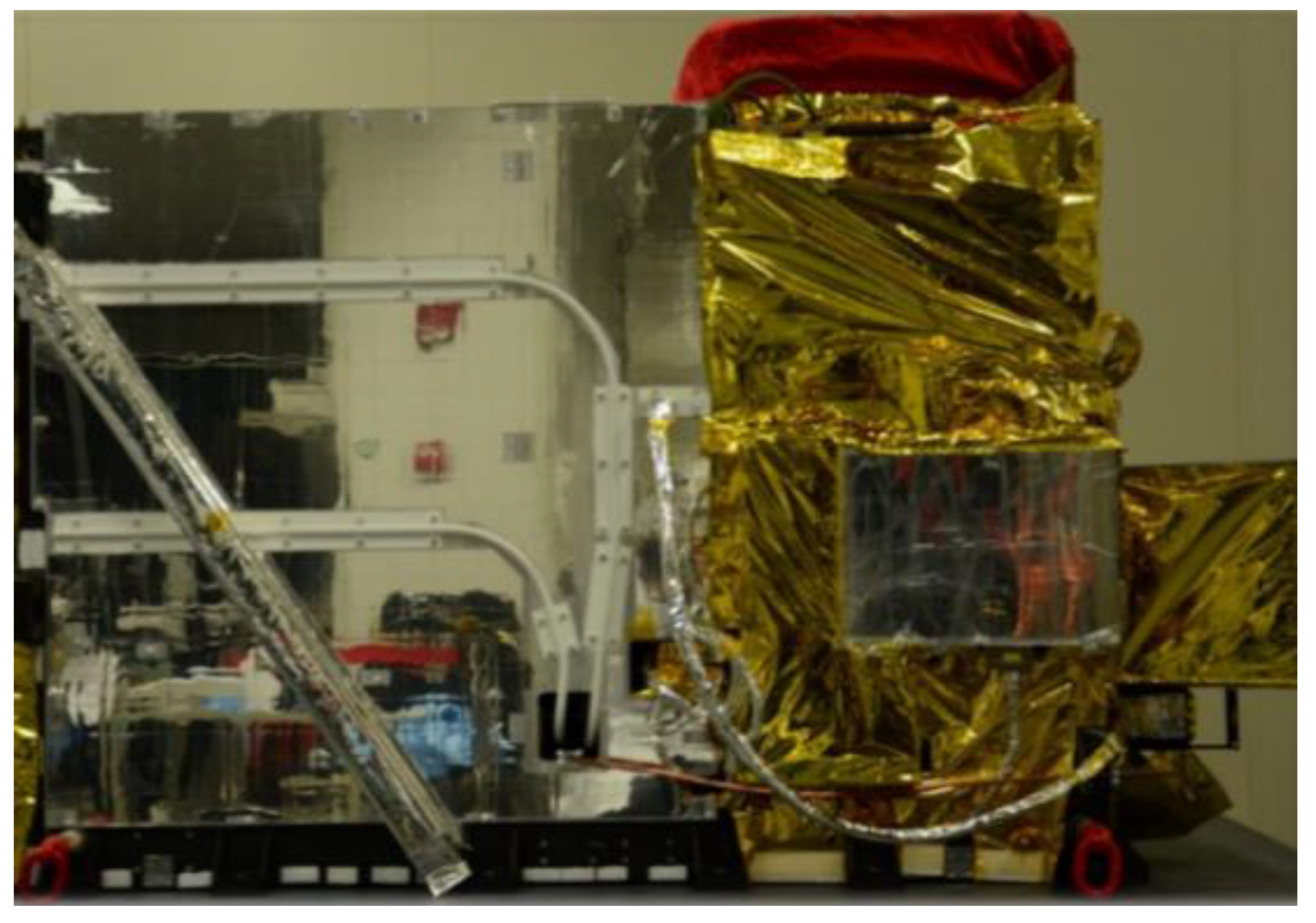
Figure 1. GF5-02 Advanced Hyperspectral Imager.
Remotesensing 15 02233 g001
Figure 2. Normalized SRF of GF5-02 AHSI Band 1 from laboratory spectral calibration.
Remotesensing 15 02233 g002
Figure 3. Normalized SRF of GF5-02 AHSI Band 84 to Band 91.
Remotesensing 15 02233 g003
Figure 4. The flowchart of the on-orbit reflectance-based radiometric calibration method of GF5-02 AHSI.
Remotesensing 15 02233 g004
Figure 5. Homogeneous desert area and automatic observation system at the RadCalNet Baotou site.
Remotesensing 15 02233 g005
Figure 6. The AHSI hyperspectral imagery of the RadCalNet Baotou site on 23 May.
Remotesensing 15 02233 g006
Figure 7. The AHSI hyperspectral imagery of the RadCalNet Baotou site on 2 April.
Remotesensing 15 02233 g007
Figure 8. The AHSI hyperspectral imagery of the RadCalNet Baotou site on 2 September.
Remotesensing 15 02233 g008
Figure 9. The mean reflectance measurements of homogeneous sand at the GF5-02 satellite overpass on 2 April, 23 May, and 2 September.
Remotesensing 15 02233 g009
Figure 10. BRDF measuring instrument.
Remotesensing 15 02233 g010
Figure 11. Synchronous measurement of atmospheric parameters at the RadCalNet Baotou site (23 May 2022). (a) Synchronous measurement of AOD. (b) Synchronous measurement of CWV.
Remotesensing 15 02233 g011
Figure 12. TOA radiance of GF5-02 AHSI predicted by Modtran6.0.
Remotesensing 15 02233 g012
Figure 13. DN from GF5-02 AHSI hyperspectral imagery.
Remotesensing 15 02233 g013
Figure 14. On-orbit calibration coefficient of the GF5-02 AHSI.
Remotesensing 15 02233 g014
Figure 15. Homogeneous natural features at the RadCalNet Baotou site. (a) 200 m × 200 m bare soil. (b) 200 m × 200 m grassland.
Remotesensing 15 02233 g015
Figure 16. Spectral reflectance measurement results of sand, bare soil, and grassland.
Remotesensing 15 02233 g016
Figure 17. The predicted TOA radiance and the calibrated TOA radiance at the RadCalNet Baotou site. (a) homogeneous sand at Baotou site. (b) bare soil at Baotou site. (c) grassland at Baotou site.
Remotesensing 15 02233 g017
Figure 18. The Gobi Desert in Dunhuang calibration site of GF5-02 AHSI imagery.
Remotesensing 15 02233 g018
Figure 19. Mean and standard deviation of surface reflectance of the Gobi Desert at Dunhuang site.
Remotesensing 15 02233 g019
Figure 20. The predicted TOA radiance and the calibrated TOA radiance of the Gobi Desert at Dunhuang site.
Remotesensing 15 02233 g020
Table 1. Key technical parameters of the GF5-02 satellite and AHSI.
GF5-02 SatelliteOrbit typeSolar synchronous orbit
Orbit altitude705 km
Equator-crossing time10:35 p.m.
Repeat cycle time51 days
Satellite weight2850 kg
Design lifetime8 years
AHSISpectral range380–2500 nm
Number of bands150 (380–1000 nm)
180 (1000–2500 nm)
330 bands in total
Spectral resolution≤5 nm (VNIR, 380–1000 nm)
≤10 nm (SWIR, 1000–2500 nm)
Signal-to-noise ratio≥200 (380–900 nm)
≥150 (900–1700 nm)
≥100 (1700–2500 nm)
Ground sampling distance30 m
Width60 km
Quantization bits12 bit
Table 2. Geometric parameters and atmospheric parameters of the GF5-02 satellite at the RadCalNet Baotou site.
GF5-02
Satellite
Overpass
(UTC)
Solar ZenithSolar
Azimuth
View Zenith View AzimuthAerosol Optical Depth @550 nmWater Vapor
2 April03:37:4740.341°197.217°0.0799°157.1350.12761.872 g/cm2
23 May03:38:1223.819°143.146°0.0636°194.773°0.09081.507 g/cm2
13 July03:38:4123.674°137.664°0.0781°194.026°0.21652.185 g/cm2
2 September03:39:4737.664°155.841°0.0928°193.9630.13931.323 g/cm2
Table 3. The ARD between calibrated TOA radiance and predicted TOA radiance.
Surface TypeSandBare SoilGrassland
ARD at Baotou site
On 13 July
5.78%6.07%6.62%
Table 4. Geometric parameters and atmospheric parameters of the GF5-02 satellite at the Dunhuang site.
GF5-02
Satellite
Overpass
(UTC)
Solar Zenith Solar
Azimuth
View Zenith View AzimuthAerosol Optical Depth @550 nmWater Vapor
29 September04:41:3244.162°161.459°0.094°193.686°0.11251.027 g/cm2
Table 5. Uncertainty analysis of absolute radiometric calibration of GF5-02AHSI.
Sources of UncertaintyUncertainty Contribution
Calibration of the reference panel1%
Surface reflectance measurement2%
BRDF correction2%
Atmospheric Aerosol Optical Depth2%
Atmospheric Aerosol type1%
Water vapor and Ozone2%
Radiative transfer model2%
Solar-target-satellite geometric parameters0.5%
Total uncertainty6.18%
Disclaimer/Publisher’s Note: The statements, opinions and data contained in all publications are solely those of the individual author(s) and contributor(s) and not of MDPI and/or the editor(s). MDPI and/or the editor(s) disclaim responsibility for any injury to people or property resulting from any ideas, methods, instructions or products referred to in the content.