

Influence of Multiple Interactions of Three Typhoons and a Mid-Latitude Cloud Band-Associated Trough in the North West Pacific upon Severe Tropical Storm Linfa


Abstract
1. Introduction
2. Study Area and Numerical Model Experiments
2.1. Geography of the Study Area
2.2. Numerical Method and Input Data
2.3. Satellite Data
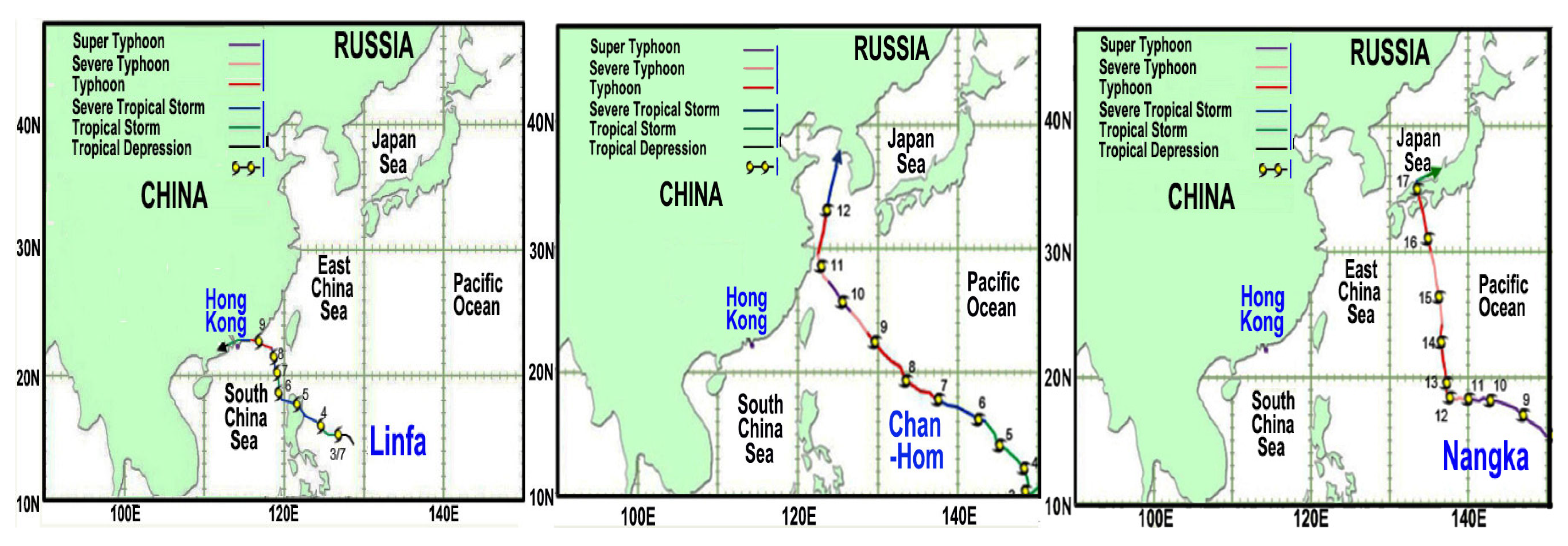
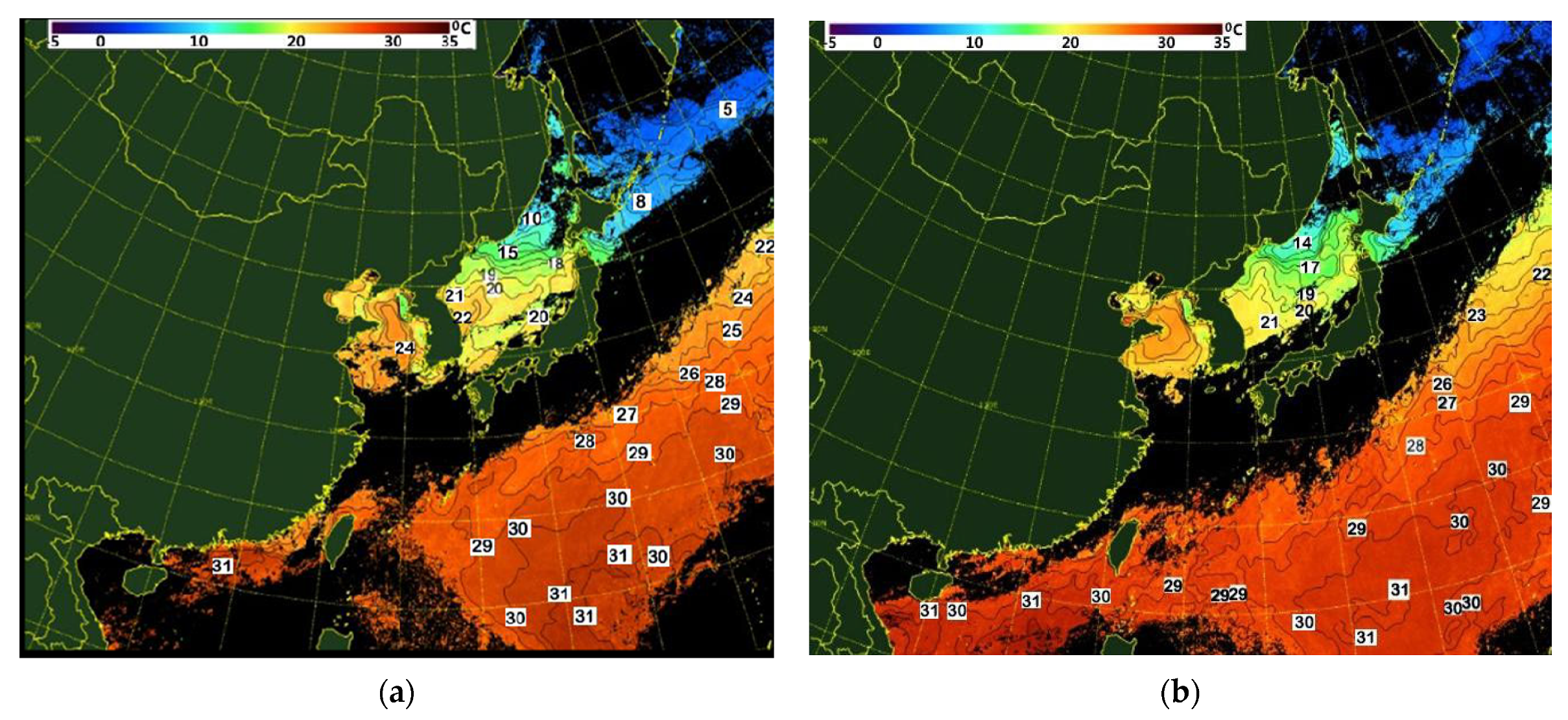
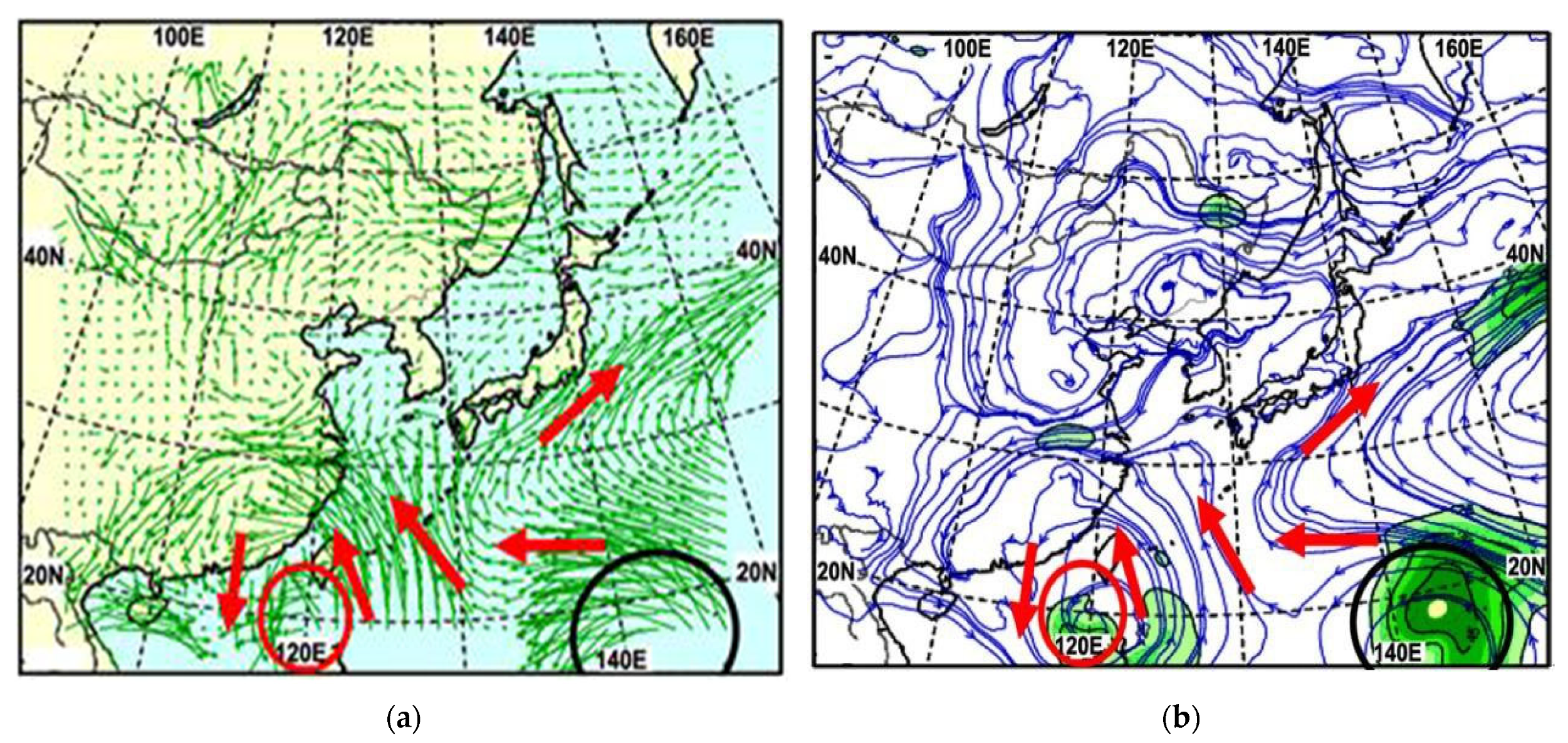
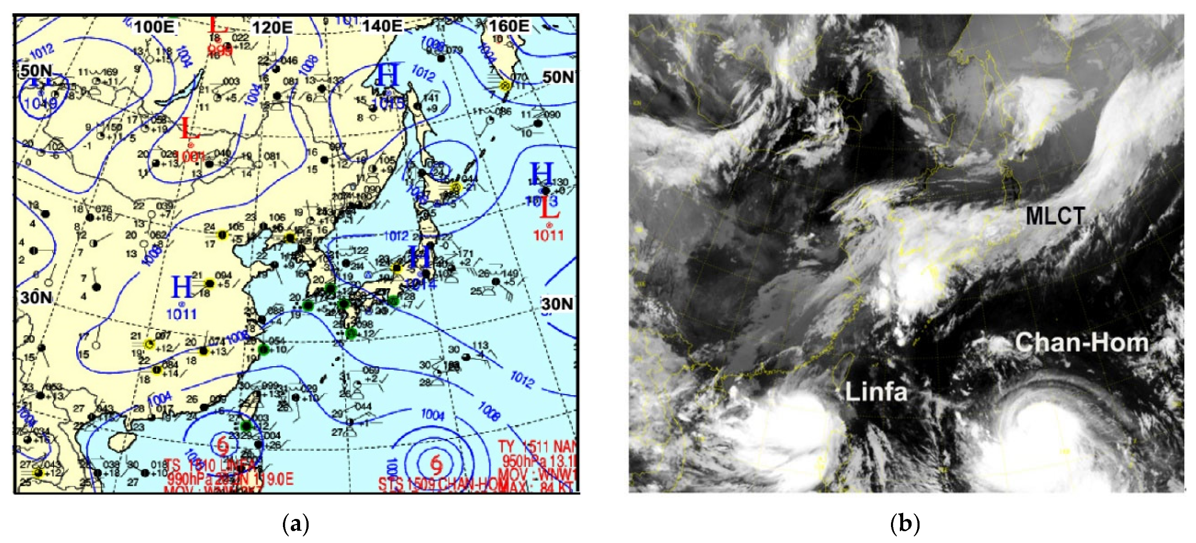
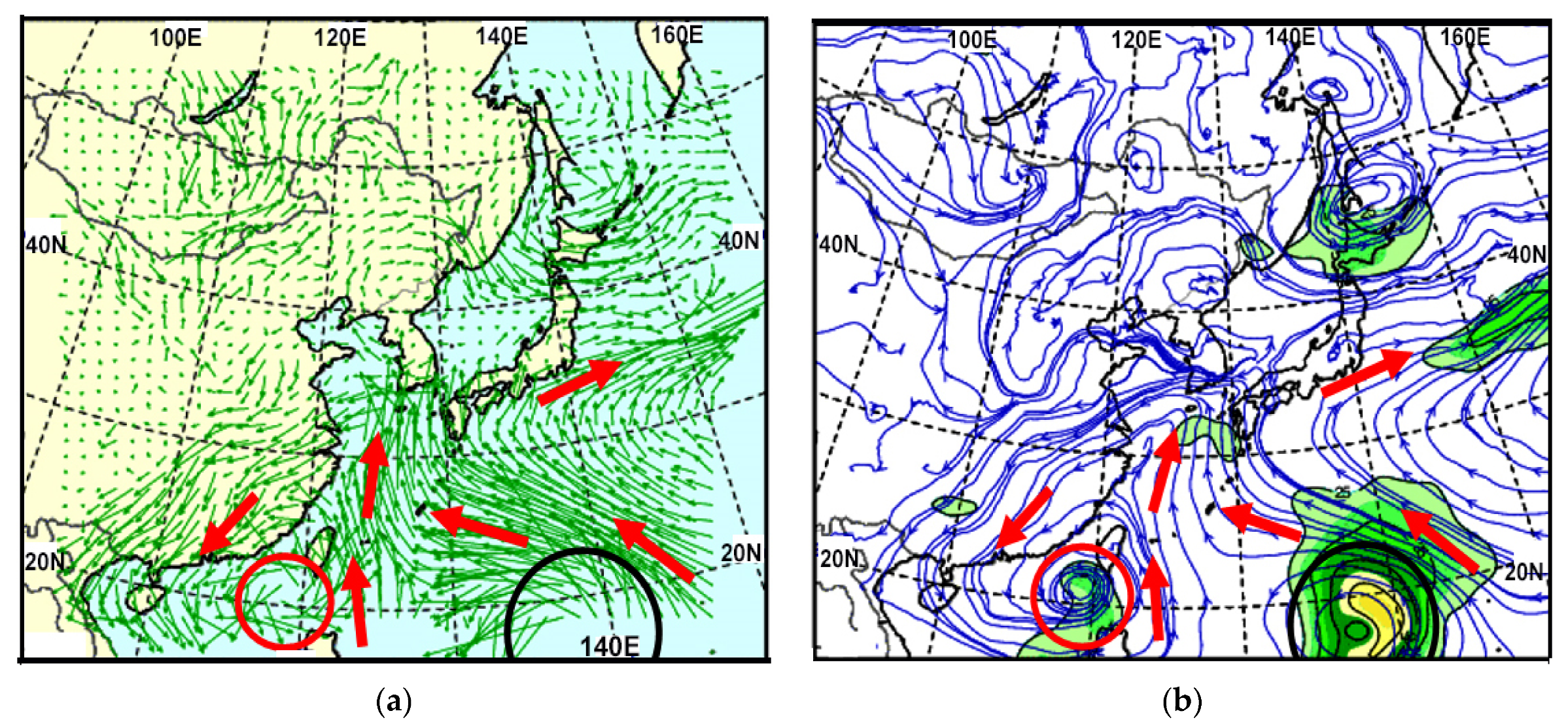
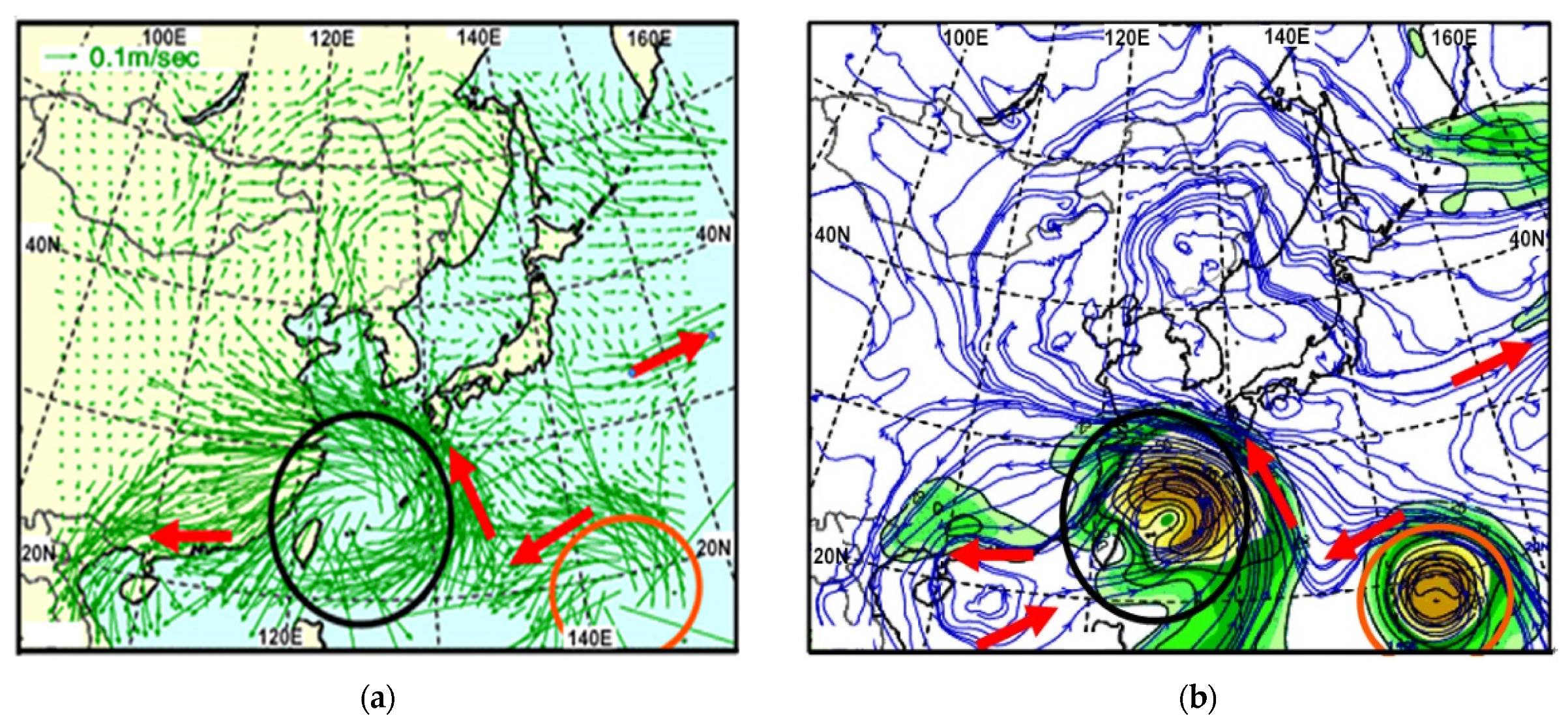
3. Results
4. Conclusions
- (1)
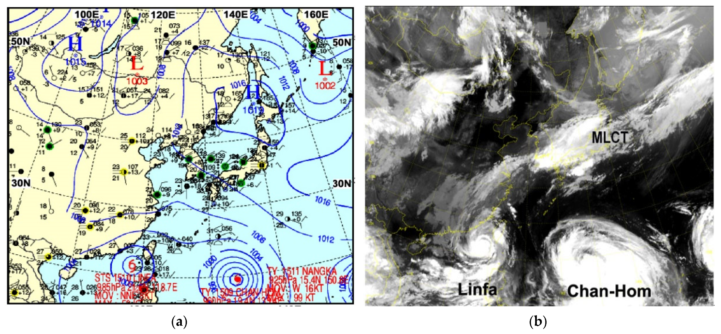
- The southwesterly wind ahead of the MLCT steered both STS Linfa and TY Chan-Hom west-northwest after both initially were steered independently to the northwest. Linfa’s cyclonic circulation intensified in its right upper quadrant turning it into a severe tropical storm without any change to Chan-Hom. As STS Linfa entered the area of 31 °C SST in the northern part of the South China Sea, it gained much more moisture due to both strong thermal convections containing water vapor from the warm sea surface and receiving a large amount of moisture from the MLCT due to their interaction, which caused Linfa to further develop;
- (2)
- As STS Linfa approached the coast, the friction of the shallower sea bottom and of the mainland of southern China itself weakened its circulation. However, the circulation of TY Chan-Hom over the open sea intensified while its interaction with the northeastward movement of the MLCT inhibited Linfa’s cyclonic circulation and weakened it the closer it became to the MLCT;
- (3)
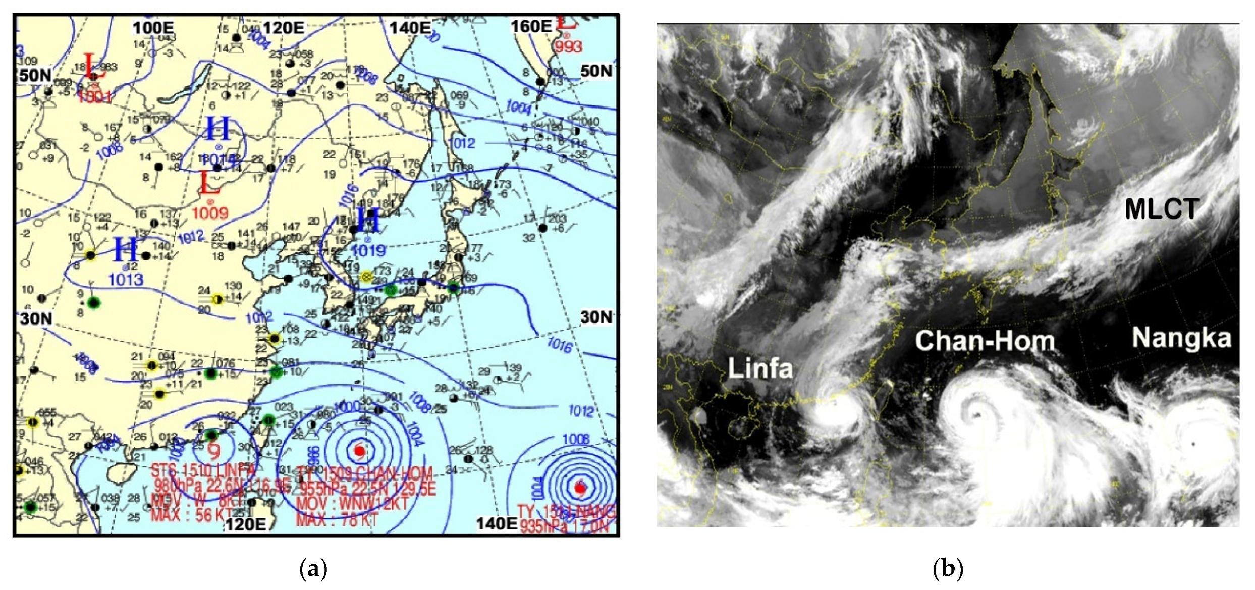
- Eventually, STS Linfa became disconnected from the MLCT and re-intensified by interacting with the more powerful TY Chan-Hom, which was moving toward the warm SST area of 30~31 °C associated with the Kuroshio Current. Enhanced moisture flux from TY Chan-Hom interacted with the strongly intensified TY Nangka and the moisture flux transferred into STS Linfa causing further development from the latent heat of condensation to form cloud clusters;
- (4)
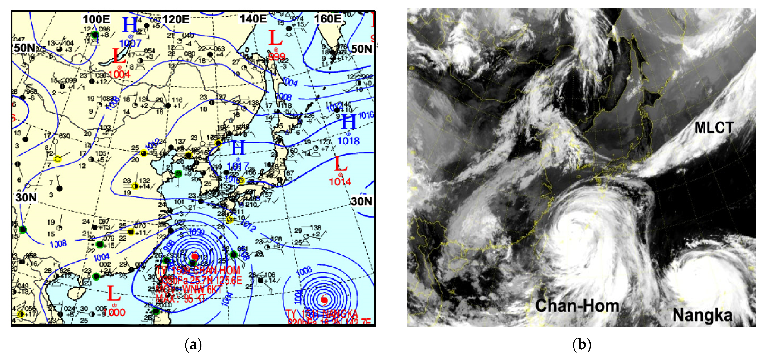
- Finally, as STS Linfa made landfall on the coast of southern China, increased friction from both the shallow sea bottom adjacent to the coast and the land itself, in addition to moisture transfer from STS Linfa to the more intense TY Chan-Hom, resulted in STS Linfa weakening into a weak low-pressure system before dissipating.
Author Contributions
Funding
Data Availability Statement
Acknowledgments
Conflicts of Interest
References
- Anthes, R.A.; Chang, S.W. Response of the Hurricane Boundary Layer to Changes of Sea Surface Temperature in a Numerical Model. J. Atmos. Sci. 1978, 135, 1240–1255. [Google Scholar] [CrossRef]
- Choi, H. Extreme decrease of air temperature modified by a typhoon passage in the Korean eastern coast. Disaster Adv. 2012, 5, 45–51. [Google Scholar]
- Hong Kong Meteorological Observatory (HKO). In Classification of Tropical Cyclones; 2012. Available online: http://www.hko.gov.hk/informtc/class.html (accessed on 10 September 2012).
- World Meteorological Organization (WMO). Guidelines for Converting between Various Wind Averaging Periods in Tropical Cyclone Conditions. 2010, pp. 1–63. Available online: https://library.wmo.int/index.php?lvl=notice_display&id=135#.ZDPa33ZByUk (accessed on 10 September 2012).
- Korea Meteorological Administration (KMA). 2013. Available online: http://www.kma.go.kr/ (accessed on 10 September 2012).
- Choi, H. Extreme cold sea outbreak near Cheju Island, Korea by strong wind and atmospheric pressure change under typhoon Rusa. Disaster Adv. 2010, 3, 32–41. [Google Scholar]
- Choi, H.; Lee, M.S.; Choi, S.M. Cold sea surface temperature near Cheju Island responding to strong cyclone wind and positive geopotential tendency behind a typhoon center along its track. J. Mar. Sci. Technol. 2012, 20, 684–692. [Google Scholar] [CrossRef]
- Subrahmanyam, M.V. Impact of typhoon on the north-west Pacific sea surface temperature: A case study of Typhoon Kaemi. Nat. Hazards 2006, 78, 569–582. [Google Scholar] [CrossRef]
- Latif, M.; Keenlyside, N.; Bader, J. Tropical sea surface temperature, vertical wind shear, and hurricane development. Geophys. Res. Lett. 2007, 34, 1–4. [Google Scholar] [CrossRef]
- Feng, G.; Subrahmanyam, M.V. Chlorophyll variations over coastal area of China due to typhoon Rananim. Indian J. Mar. Sci. 2018, 47, 804–811. [Google Scholar]
- Price, J.F. Upper ocean response to a hurricane. J. Phys. Ocean. 1981, 11, 153–175. [Google Scholar] [CrossRef]
- Gill, A.E. Atmosphere-Ocean Dynamics; Academic Press: New York, NY, USA, 1982; pp. 1–662. [Google Scholar]
- Knauss, J.A. Introduction to Physical Oceanography, 2nd ed.; Waveland Press, Inc.: Long Grove, IL, USA, 1997; pp. 1–309. [Google Scholar]
- Franklin, J.L.; Lord, S.J.; Feuer, S.E.; Marks, F.D., Jr. The Kinematic Structure of Hurricane Gloria (1985) Determined from Nested Analyses of Dropwindsonde and Doppler Radar Data. Mon. Weather. Rev. 1993, 121, 2433–2451. [Google Scholar] [CrossRef]
- Sheng, J.; Zhai, X.; Greatbatch, R.J. Numerical study of the storm-induced circulation on the Scotian Shelf during Hurricane Juan using a nested-grid ocean model. Prog. Oceanogr. 2006, 70, 233–254. [Google Scholar] [CrossRef]
- Cheung, T.C.; Chan, P.W. Improving Wind and Rain Simulations for Tropical Cyclones with the Assimilation of Doppler Radar Data. In Proceedings of the 10th Annual WRF Users’ Workshop, Boulder, CO, USA, 23–26 June 2009; pp. 1–835. [Google Scholar]
- Dhana, L.D.; Annapurnaiah, K. Impact of microphysical schemes in the simulations of cyclone Hudhud using WRF-ARW model to find out the best microphysics for accurate simulation of intensity and track of tropical cyclone. Int. J. Oceans Ocean. 2016, 10, 49–59. [Google Scholar]
- Shyam, A.; Sharma, N. Ocean surface winds from Aquarius L-band Radiometer during Tropical Cyclones: Case Studies. Int. J. Oceans Ocean. 2018, 12, 147–158. [Google Scholar]
- Fujiwhara, S. The natural tendency towards symmetry of motion and its application as a principle in meteorology. Q. J. R. Meteorol. Soc. 1921, 47, 287–292. [Google Scholar] [CrossRef]
- Liu, K.Y. On the Relative Motion of Typhoon Pairs Over the South China Sea and Northwest Pacific Region; NSC73-0202-M072-02; NSC: Taipei, China, 1983; pp. 1–38. [Google Scholar]
- DeMaria, M.; Chan, J.C.L. Comments on “A Numerical Study of the Interactions between Two Tropical Cyclones”. Mon. Weather. Rev. 1983, 112, 1643–1645. [Google Scholar] [CrossRef]
- Kuo, H.-C.; Chen, G.T.-J.; Lin, C.-H. Merger of Tropical Cyclones Zeb and Alex. Mon. Weather. Rev. 2000, 128, 2967–2975. [Google Scholar] [CrossRef]
- Xu, H.; Zhang, X.; Xu, X. Impact of Tropical Storm Bopha on the Intensity Change of Super Typhoon Saomai in the 2006 Typhoon Season. Adv. Meteorol. 2013, 2013, 487010. [Google Scholar] [CrossRef]
- Choi, H.; Lee, M.S. Tropical storm Sarika merging in Typhoon Songda circulation by strong wind and sufficient moisture transportation. Disaster Adv. 2015, 8, 1–7. [Google Scholar]
- Yeh, K.D.; Liu, J.C.; Eea, M.; Lin, C.H.; Lu, W.L.; Chiang, C.T.; Lee, Y.S.; Chen, A.H.C. Intensification and decay of typhoon Nuri (2014) associated with cold front and southwesterly airflow observed in satellite cloud images. J. Mar. Sci. Technol. 2017, 25, 599–606. [Google Scholar] [CrossRef]
- Wikipedia. North Pacific High. 2023. Available online: https://en.wikipedia.org/wiki/North_Pacific_High (accessed on 10 September 2012).
- Wikipedia. 2015 Pacific Typhoon Season. 2015. Available online: https://en.wikipedia.org/wiki/2015_Pacific_typhoon_season (accessed on 10 September 2012).
- Danard, M.B. On the Influence of Released Latent Heat on Cyclone Development. J. Appl. Meteorol. 1964, 3, 27–37. [Google Scholar] [CrossRef]
- Miller, W.; Chen, H.; Zhang, D.L. On the intensification of Hurricane Wilma (2005), Part III: Effects of latent heat of fusion. J. Atmos. Sci. 2015, 72, 3829–3849. [Google Scholar] [CrossRef]
- Li, M.; Ping, F.; Chen, J.; Xu, L. A simulation study on the rapid intensification of Typhoon Megi (2010) in vertical wind shear. Atmospheric Sci. Lett. 2016, 17, 630–638. [Google Scholar] [CrossRef]
- DeMaria, M.; Kaplan, J. Sea Surface Temperature and the Maximum Intensity of Atlantic Tropical Cyclones. J. Clim. 1994, 7, 1324–1334. [Google Scholar] [CrossRef]
- DeMaria, M. The effect of vertical shear on tropical cyclone intensity change. J. Atmos. Sci. 1996, 53, 2076–2087. [Google Scholar] [CrossRef]
- Frank, W.M.; Ritchie, E.A. Effects of Vertical Wind Shear on the Intensity and Structure of Numerically Simulated Hurricanes. Mon. Weather. Rev. 2001, 129, 2249–2269. [Google Scholar] [CrossRef]
- Corbosiero, K.L.; Molinari, J. The Effects of Vertical Wind Shear on the Distribution of Convection in Tropical Cyclones. Mon. Weather. Rev. 2000, 130, 2110–2123. [Google Scholar] [CrossRef]
- Riemer, M.; Montgomery, M.T.; Nicholls, M.E. Further examination of the thermodynamic modification of the inflow layer of tropical cyclones by vertical wind shear. Atmos. Chem. Phys. Discuss. 2013, 13, 327–346. [Google Scholar] [CrossRef]
- Chen, H.; Zhang, D.-L. On the Rapid Intensification of Hurricane Wilma (2005). Part II: Convective Bursts and the Upper-Level Warm Core. J. Atmos. Sci. 2013, 70, 146–162. [Google Scholar] [CrossRef]


| Date | Surface Pressure (hPa) | Position | Maximum Surface Wind (m/s) (kt) | Moving Speed (km/h) |
|---|---|---|---|---|
| TS-L 09:00 LST, 4 July | 990 | 15.3°N; 124.2°E | 24 (48) | 3 |
| TY-C | 985 | 12.4°N; 148.2°E | 27 (54) | 21 |
| TY-N | 1000 (a low) | 10.2°N; 170.0°E | 18 (36) | 25 |
| STS-L 09:00 LST, 5 July | 985 (−5) | 17.2°N; 122.1°E | 27 (54) (+3) | 11 |
| TY-C | 985 (0) | 14.2°N; 144.8°E | 27 (54) (0) | 11 |
| TY-N | 990 (−10) | 11.5°N; 164.8°E | 24 (48) (+6) | 20 |
| STS-L 09:00 LST, 6 July | 992 (+7) | 18.5°N; 119.4°E | 23 (46) (−4) | 11 |
| TY-C | 980 (−5) | 16.3°N; 142.5°E | 29 (58) (+2) | 19 |
| TY-N | 980 (−10) | 11.7°N; 159.9°E | 29 (58) (+5) | 29 |
| STS-L 09:00 LST, 7 July | 985 (−7) | 20.2°N; 119.0°E | 27 (54) (+4) | 4 |
| TY-C | 975 (−5) | 18.0°N; 137.6°E | 32 (64) (+3) | 21 |
| TY-N | 950 (−30) | 13.1°N; 155.5°E | 43 (86) (+14) | 25 |
| STS-L 09:00 LST, 8 July | 985 (0) | 21.6°N; 118.7°E | 27 (54) (0) | 11 |
| TY-C | 960 (−15) | 19.4°N; 133.4°E | 39 (78) (+7) | 17 |
| TY-N | 925 (−25) | 15.6°N; 151.1°E | 51 (102) (+8) | 24 |
| STS-L 09:00 LST, 9 July | 980 (−5) | 22.5°N; 117.7°E | 29 (58) (+2) | 13 |
| TY-C | 955 (−5) | 22.5°N; 129.5°E | 40 (80) (+1) | 23 |
| TY-N | 935 (−10) | 17.0°N; 146.9°E | 49 (98) (−2) | 20 |
| STS-L 09:00 LST, 10 July | 1000 (a low) | 22.6°N; 112.4°E | Unreported | 23 |
| TY-C | 935 (−20) | 25.7°N; 125.6°E | 49 (98) (+9) | 20 |
| TY-N | 920 (−15) | 18.2°N; 142.7°E | 53 (106) (+4) | 16 |
Disclaimer/Publisher’s Note: The statements, opinions and data contained in all publications are solely those of the individual author(s) and contributor(s) and not of MDPI and/or the editor(s). MDPI and/or the editor(s) disclaim responsibility for any injury to people or property resulting from any ideas, methods, instructions or products referred to in the content. |
© 2023 by the authors. Licensee MDPI, Basel, Switzerland. This article is an open access article distributed under the terms and conditions of the Creative Commons Attribution (CC BY) license (https://creativecommons.org/licenses/by/4.0/).
Share and Cite
Choi, S.-M.; Choi, H. Influence of Multiple Interactions of Three Typhoons and a Mid-Latitude Cloud Band-Associated Trough in the North West Pacific upon Severe Tropical Storm Linfa. Remote Sens. 2023, 15, 2170. https://doi.org/10.3390/rs15082170
Choi S-M, Choi H. Influence of Multiple Interactions of Three Typhoons and a Mid-Latitude Cloud Band-Associated Trough in the North West Pacific upon Severe Tropical Storm Linfa. Remote Sensing. 2023; 15(8):2170. https://doi.org/10.3390/rs15082170
Chicago/Turabian StyleChoi, Soo-Min, and Hyo Choi. 2023. "Influence of Multiple Interactions of Three Typhoons and a Mid-Latitude Cloud Band-Associated Trough in the North West Pacific upon Severe Tropical Storm Linfa" Remote Sensing 15, no. 8: 2170. https://doi.org/10.3390/rs15082170
APA StyleChoi, S.-M., & Choi, H. (2023). Influence of Multiple Interactions of Three Typhoons and a Mid-Latitude Cloud Band-Associated Trough in the North West Pacific upon Severe Tropical Storm Linfa. Remote Sensing, 15(8), 2170. https://doi.org/10.3390/rs15082170