Abstract
Environmental assessments are important tasks for the long-term, sustainable development of cities. With the rapid urbanization in China, it is crucial to establish a City Sustainability Index (CSI) and evaluate the environmental conditions in major cities. However, most of the existing major sustainability indices/indicators are not able to assess cities at diverse levels of development using common axes of evaluation. In this work, we incorporate urban built-up areas extracted from high-resolution remote sensing images as indicators to measure the degree of urban development in city sustainability evaluation and propose a comprehensive index, i.e., the Urban Geographic Environment Index (UGEI). In order to eliminate the impact of urban development levels, UGEI mainly consists of area-averaged indices which are calculated from original indices and urban built-up areas. We adopt a comprehensive weighting method by using the analytic hierarchy process (AHP) method to weigh the high-level indicators and using the entropy weighting method to weigh low-level indicators. We evaluate the environmental conditions of 30 China’s provincial capitals from the aspects of pressure, state, response, and overall status. In addition, we analyze how diverse types of indicators affect the values of UGEIs. The major findings are as follows: (1) About half of the provincial capitals in China have poor sustainability in environmental conditions, and more environmental protection measures should be taken in developing cities; (2) the environmental conditions of the provincial capitals in China present a four-region distribution pattern, namely, the northeastern coastal region, northwest inland region, southwest region, and southeast region; (3) and indices based on urban built-up extents can be common axes of evaluation for cities at diverse levels of development. The proposed UGEI can serve as an effective and reliable index for sustainability evaluation in environmental conditions.
1. Introduction
Sustainable development in urban built-up areas is at the core of the implementation of the UN 2030 Agenda and the Sustainable Development Goals (SDG) []. Despite the fact that cities are usually developed with great geolocational considerations [,], they are more vulnerable to environmental problems. Since the reform and opening up, China’s rapid urbanization has complicated urban patterns [,]. Numerous challenges remain to be solved, such as resource constraints, serious environmental pollution, and degraded ecosystems [,]. Developing renewable energy (RE) is an essential approach to promoting sustainable urban development. Assessment of city sustainability can provide essential information for RE infrastructures location optimization and spatial distribution estimation.
In 1987, the World Commission on Environment and Development proposed the concept of sustainable development. In 1992, the Earth Summit proposed to develop Agenda 21 []. Since then, numerous efforts on indicator systems of ecological environment evaluation as well as city sustainability have been made. The widely used sustainability indices can be divided into two categories: (1) indicator-based indices and (2) single-unit indices. Indicator-based indices include the Environmental Sustainability Index (ESI) [], Environmental Performance Index (EPI) [], Eco-functional Quality Index [], Index of Environmental Friendliness [], Environmental Policy Performance Indicator [], Environmental Vulnerability Index [], Environmental Degradation Index [], Index of Environmental Indicators [], City Biodiversity Index, Gross City Development Index (GCD-Index) [], Human Development Index (HDI) [], Living Planet Index (LPI) [], City Development Index (CDI) [], Green City Index (GCI) [], and Global Urban Index (GUI), to name a few. Notable single-unit indices include Ecological Footprint (EF) [,], Ecological Efficiency Law [], Water Footprint, Index of Sustainable Economic Welfare, Genuine Progress Indicator, Environmentally adjusted Domestic Product, and Genuine Saving, to name a few. Despite the existence of diverse types of many indices/indicators, the assessment framework of city sustainability has not yet been well established due to the fact that the required conditions for city sustainability assessment are still ambiguous.
In 2012, Mori and Christodoulou (2015) discussed the problems that exist in sustainability indices and indicators, including the concept of sustainability, the boundary of a city, city sustainability, and the gap between developed and developing countries. They put forward four key conceptual requirements for an adequate city sustainability index after reviewing many indices and proposed a methodological framework of sustainability assessment of the city sustainability index, providing essential theoretical support for urban sustainability evaluation. Scholars have also conducted investigations on the impact of different urban definitions and boundary division methods on urban sustainability evaluation indicators [,,].
To the best of our knowledge, however, few city sustainability indices consider the urban built-up boundaries rather than political boundaries, as shown in Table 1. Most of the city sustainability indices only include original indicators and per capita indicators, which tend to over/underestimate developed cities as compared to developing cities [,,,]. In addition, the specific impacts of diverse types of indicators, i.e., original indicators, per capita indicators, and area-averaged indicators, on urban sustainability are still unclear.

Table 1.
City sustainability indices and indicator types.
Satellite remote sensing monitoring [] is an important way to obtain objective data about the city quickly []. In this study, we aim to incorporate urban built-up areas extracted from high-resolution remote sensing images into city sustainability evaluation and analyze how different types of indicators affect the values of city sustainability indices. We take the provincial capital cities of China as the research area. We discuss the impacts of different types of indicators by making comparisons and confirming the objectivity and reliability of the proposed UGEI model. The environmental conditions of China’s provincial capitals are analyzed from the aspects of pressure, state, response, and overall status.
2. Study Area and Datasets
Our study area includes 30 provincial capital cities of China, excluding Hong Kong, Macao, Taiwan, and Lhasa (Figure 1). The provincial capital cities are generally the political, economic, scientific, educational, and cultural centers of provinces. These cities have experienced rapid economic and social development with high urbanization levels but facing great environmental challenges. Therefore, performing environmental assessments on these cities is significant. Our data primarily originates from two sources, namely, the First National Geographic Survey Project of China and statistical yearbooks. The First National Geographic Survey Project provides data on land cover and remote sensing imagery. The statistical yearbooks include both the China Statistical Yearbook (2016) and the China City Statistical Yearbook (2016). Panel data on provincial capital cities are mainly obtained from the aforementioned statistical yearbooks. The First National Geographic Survey Project of China provided comprehensive coverage of mainland land territory and accurately reflected actual ground conditions, with the land cover being a significant component of the census. Geographical conditions data were collected from multiple sources, verified, processed, integrated, and released by national-level institutions, making it more comprehensive, accurate, and credible than public land cover data. By utilizing these data for sustainability analysis, a more comprehensive and accurate understanding and evaluation of target areas can be achieved, providing reliable support for decision making.
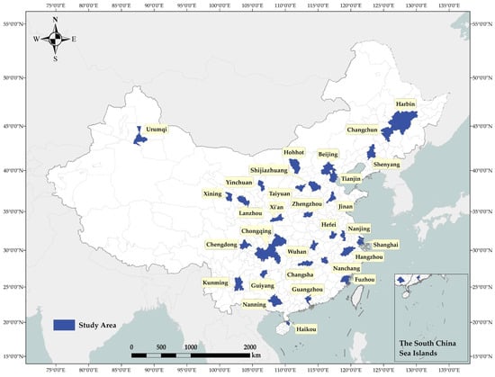
Figure 1.
The geographic locations of 30 provincial capital cities of (our study area).
3. The UGEI Model
Establishing a reasonable framework for the evaluation index is essential for ecological environment studies. A comprehensive evaluation of the ecological environment is a complex task, as the state of the ecological environment can be affected by many factors. On the basis of AHP [], these influencing factors can be grouped based on their dominance. In accordance with the PSR model proposed by the UN Commission on Sustainable Development, these factors can be divided into three major groups, i.e., factors on stress, state, and response. The selection of factors is represented by the corresponding indicators that should be able to express the influencing factors of the ecological environment and be easily accessible.
In this study, following the PSR model, the proposed UGEI model (Figure 2) also involves three factors, namely, stress, state, and response. From these 3 basic elements, 20 indicators are selected to construct the indicator system. When selecting indicators, we consider forests, grasslands, cultivated land, wetlands, construction land, atmosphere, and other aspects that are closely related to the urban geographic environments. Table 2 presents the specific indicator system.
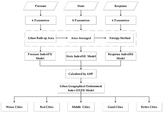
Figure 2.
The proposed UGEI Framework.
Environmental pressures are mainly analyzed from the aspects of population, industrial structure, and pollutant emissions. P1 reflects the population pressure, P2 represents the industrial pressure, and P3–P6 reflects typical pollutants and waste disposal. The state of the environment depends on the abundance of organisms, land cover [], and water and air quality. S1 is a biological abundance index that is widely used to reflect biological abundance, S2 reflects the building area in land cover, S3–S6 reflect the distribution of cultivated land, forest land, grassland, and other vegetation coverage lands [,], S7 reflects the water resource status, and S8 shows the overall situation of air quality. Human responses are key factors that mainly include prevention, protection, afforestation, and investment. R1 reflects the afforestation situation, R2 and R3 reflect the environmental protection investments, and R4–R5 reflect the pollution control. S1–S7 originate from remote sensing monitoring in China’s first national geographic survey, and the others are from the statistical yearbook.

Table 2.
Indices included in the proposed UGEI Framework.
Table 2.
Indices included in the proposed UGEI Framework.
| Subindex | Composition | Indicator Content | Unit | References |
|---|---|---|---|---|
| Pressure index | Population | P1. Population | Ten thousand people | [,,,,,] |
| P2. Natural population growth rate | % | |||
| Industrial structure | P3. Second industry share | % | ||
| Emissions | P4. General industrial solid waste production | 10,000 tons | ||
| P5. Wastewater discharge | million tons | |||
| P6. Emissions of major pollutants from waste gas | one hundred tons | |||
| State index | Biomass | S1. Biological abundance index | dimensionless | [,,,,,,,,] |
| Surface coverage | S2. Building land area | square kilometer | ||
| S3. Cultivated land area | square kilometer | |||
| S4. Forest area | square kilometer | |||
| S5. Grassland area | square kilometer | |||
| S6. Other vegetation coverage areas | square kilometer | |||
| S7. Water area | square kilometer | |||
| Air quality | S8. Good air days throughout the year | day | ||
| Response index | Planting trees | R1. Afforestation area | square kilometer | [,,,,,,] |
| Environmental investment | R2. Investment in water conservancy, environment, and public facilities management | billion | ||
| R3. Agriculture, forestry, animal husbandry, and fishery investment | billion | |||
| Pollution control | R4. Centralized treatment rate of sewage treatment plant | % | ||
| R5. General industrial solid waste comprehensive utilization rate | % | |||
| R6. Harmless treatment rate of domestic garbage | % |
3.1. Data Preprocessing
A comprehensive evaluation model tends to have many indicators with diverse types, as each index has its own characteristics and scope. Consequently, evaluation indicators are difficult to compare directly. Therefore, raw data must be preprocessed and standardized. Our preprocessing and standardization steps are as follows:
- The specific indicator values are obtained from the statistics of the national condition survey, urban built-up area products from remote sensing monitoring, and the statistical yearbook.
- Units of the same type of indicators are unified.
- As for indicators of the percentage and dimensionless types, the ratio of other indicator values to the urban built-up area of the city is used as the average indicator.
After the preprocessing, we have to perform standardization so that indicators can be dimensionless. We adopt the range conversion method as our standardization approach. The standardization processes for forward and negative indices are elucidated by Equation (1) and Equation (2), respectively. Note that the S2 index is a negative indicator.
where represents the city serial number, is the indicator number, is a standardized value, is the initial value, is the minimum value of each indicator, and is the maximum value of each indicator.
3.2. Urban Built-Up Area Extraction from High-Resolution Remote Sensing Imagery
Remote sensing technologies can provide practical, cost-effective, and relatively objective solutions for observational studies of urban built-up areas. Urban built-up areas are extracted by means of manual interpretations based on high-resolution remote sensing imagery. First, we collect remote sensing images of 30 provincial capital cities and produce Color-Digital Orthophoto Map. Second, we choose the initial urban built-up area where the district government is located and with concentrated contiguous buildings. Third, we extract rough urban built-up areas taking actual city construction and urban landscape into consideration [,]. Then, we refine the urban built-up areas under the four principles. Finally, we get the final urban built-up areas after cross-checking. Some examples are shown in Figure 3. The six principles are as follows:

Figure 3.
Examples of urban built-up areas extracted from remote sensing imagery: (a) urban built-up area of Xining; (b) urban built-up area of Lanzhou; (c) urban built-up area of Kunming.
- (1)
- An urban built-up area must be within the administrative divisions of the city.
- (2)
- An urban built-up area outline is preferentially drawn along the boundary of linear objects.
- (3)
- Urban landscapes are important features of urban built-up areas. Figure 4 shows some typical marks of urban landscapes.
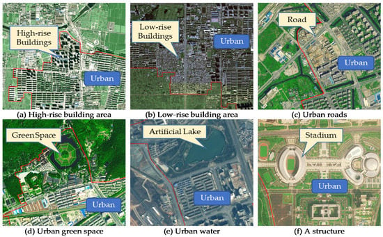 Figure 4. Examples of urban feature interpretation symbols in remote sensing imagery: (a) high-rise building area; (b) low-rise buildings area; (c) urban road; (d) green space near the edge of urban built-up area; (e) an example of urban water, namely an artificial lake; (f) an example of structure, namely a stadium. The red line in the figure represents the boundary of the urban built-up area.
 - (4)
- Judgment of central urban built-up areas and enclave urban built-up areas. The central centralized and contiguous region is a central urban built-up area. The large regions with significant urban landscapes (away from the central urban built-up area but near the central city) are enclave urban built-up areas.
The satellite images we used were taken in the fourth quarter of 2015. The satellite (image resolution) and coverage percentages are as follows: WorldView-1/2 (0.5 m), accounting for 23.74%; Aerial images (0.5 m), accounting for 22.25%; ZY-3 (2.1 m), accounting for 19.65%; SPOT 6/7 (1.5 m), accounting for 17.74%; and Pleiades (0.5 m), accounting for 16.62%.
3.3. Comprehensive Weighting Method
This study employs a comprehensive weighting approach that combines AHP and the entropy weighting method. AHP is a useful tool that allows the integration of expert knowledge to evaluate the weights of high-level indicators, thereby achieving a relatively unbiased assessment outcome. Nevertheless, obtaining indicator weights that accurately reflect the actual situation can be challenging for underlying indicators, particularly when a large number of them are involved. In addition, the utilization of AHP in dealing with a large number of indicators may result in conflicts in indicator weights. Therefore, the entropy weighting method is selected to calculate weights based on the objective distribution of the data. To address these challenges, our proposed approach combines AHP and the entropy weighting method by using AHP to weigh high-level indicators and the entropy weighting method to weigh low-level indicators. The comprehensive weighting method, which combines the advantages of AHP and entropy weighting method, can more objectively calculate indicator weights and fully utilize their respective strengths to obtain more comprehensive and accurate results. This approach can contribute to improving the accuracy and effectiveness of evaluations.
3.3.1. Analytic Hierarchy Process
The weights of three factors, namely, pressure, state, and response, were calculated by using the AHP method and you could calculate these by using []’s methods.
- Our judgment matrix is as follows:
- 2.
- Calculate the eigenvalue and eigenvector.
Then, we can get the eigenvector from the equation so that we can obtain the weight of the criteria hierarchy by normalizing . Eigenvectors: [0.3333, 0.6666, 0.3333] and is 3.
- 3.
- Check consistency:
The AHP analysis resulted in the final weights of 0.25, 0.5, and 0.25 for pressure, state, and response.
3.3.2. Entropy Weight Method
The entropy method is an objective weighting technique that assigns a higher weight to uncertain outcomes. It has been widely used to evaluate urban ecosystems, including the living environment, ecological environment, and economic development. Using information entropy can reveal each indicator’s utility and reduce subjective factors, making it more credible and objective than subjective methods for evaluating multiple variables. The principles of the entropy method are as follows:
- Data matrix. The normalized data of the indicators are taken as an matrix, where is defined as the number of evaluation objects and indicates the number of indicators. Hence, the normalized data matrix of the index system can be expressed as Equation (7):
- 2.
- Data normalization. The standardization processes for forward and negative indices are elucidated by Equations (8) and (9), respectively.
- 3.
- Calculate the entropy of each indicator. To calculate the entropy value of each indicator, the standardized value of indicator for object must first be calculated, and is written as Equation (10):
Then, calculate the entropy value of the th indicator using Equation (11):
where .
- 4.
- Calculate the entropy weight of each criterion. The weighting value of the th indicator is defined as Equation (12):
In Appendix A, relevant data are provided, where Table A1 presents the original data of UGEI’s tertiary indicators and Table A2 provides the weighted data results after applying the entropy weight method.
3.4. The Calculation of the UGEI
The proposed UGEI is a comprehensive index that involves multiple aspects. A more systematic and intuitive evaluation can be obtained by hierarchically calculating the comprehensive index. The specific calculation process is as follows:
- Pressure index calculation
- 2.
- State index calculation
- 3.
- Response index calculation
The weights of the indicators in the proposed model are shown in Table 3. The weights of the stress, state, and response indices are calculated by the AHP, whereas the weights of the sub-level indicators are calculated via the entropy weight method. Table 3 shows the weights of each indicator.

Table 3.
Weights of UGEI indicators.
3.5. Index Grading Based on Natural Discontinuities
After the calculation of the pressure, state, response, and final UGEI, index values are reclassified using natural discontinuity grading, and the regional hierarchical thematic maps are created.
The principle of natural discontinuous grading is to sort all samples from small to large and then identify the natural breakpoints in the sample distribution by deriving the intraclass variances by comparing the intraclass and interclass errors. The principle of minimum and maximum variance between classes is to optimize the classification to achieve an improved classification. The specific formula is as follows:
where is the variance, and are the class numbers, is the data set of the class, and is the average within the class.
4. Results and Analysis
In the calculation of the UGEI, the state index has the largest weight among the three types of indicators (i.e., pressure, state, and response). The pressure index reflects stress from human economic and social activities in the traditional PSR model. Opposite to the pressure index, the response index represents mitigation measures for environmental protection. The pressure and response indices characterize either the bad or good influence of the environment. In general, environments are expected to deteriorate with high pressure and low response. Conversely, environments are expected to improve with low pressure and high response. In terms of environmental quality, the state index, mainly from remote sensing monitoring, is able to characterize the current environment state, while the pressure and response indicators fail to do so. In this study, the environmental state is measured from aspects where the environment, such as biology, water, air, and land cover, plays an important and positive role in daily activities.
4.1. Pressure Index Analysis
Figure 5 shows that 16 (54%) provinces have moderate or high performance in terms of environmental pressure. Among them, Guiyang stands out as its environmental pressure is particularly high. The comparison of the initial weighted data (Figure 6) shows that the general industrial solid waste generated in Guiyang is extremely high (12,098,800 tons), much higher than that for the same period in Beijing (7,098,800 tons). In comparison, Haikou only has 46,000 tons in terms of industrial solid waste generation. In addition, Guiyang’s sewage discharge and emissions of major pollutants in exhaust gas are relatively high, indicating its high pressure on industrial pollution. The same problem occurs for Shijiazhuang, Taiyuan, Kunming, Hohhot, and Yinchuan. Urumqi’s sewage discharge index (1.811 billion tons) is much higher than those of other cities. For example, the sewage discharge in Beijing is 1.642 billion tons, and that in Changsha is 51 million tons. However, Beijing’s urban built-up area covers 9.979 million square kilometers, approximately four times the area of Urumqi (2.194 million square kilometers). The above results point to the severity of sewage discharge issues in Urumqi. Sewage treatment has always been a major problem in Urumqi. Given that most treatment plants were built early, the related equipment failed to be updated and upgraded in time, resulting in serious sewage discharge problems. Cities with sewage discharge problems also include Nanchang and Shijiazhuang. In general, Beijing, Shanghai, Hangzhou, and Tianjin have low environmental pressure, as these cities are well-developed with economic advantages that help them deal with environmental problems.
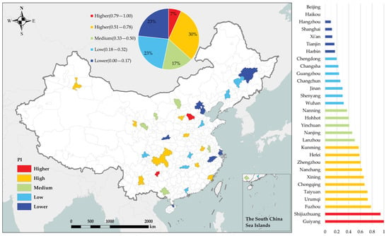
Figure 5.
Pressure index map.
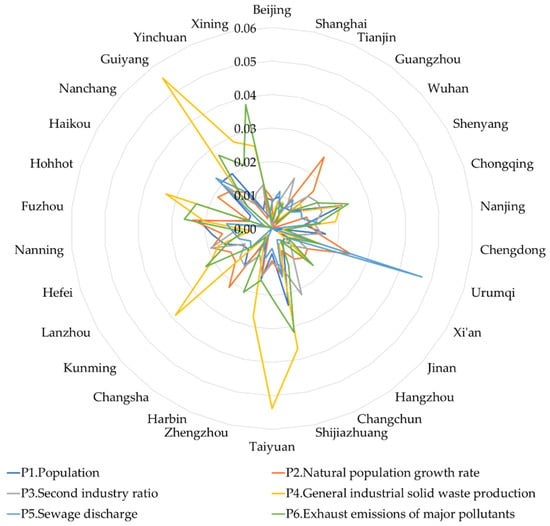
Figure 6.
Weighted comparison of sub-indicators in pressure index.
Our evaluation results also show that Chongqing, Shijiazhuang, Fuzhou, Guiyang, and Hefei are facing more severe population pressure compared to other cities, whereas Beijing, Shanghai, Guangzhou, Tianjin, and other first-tier cities have low population pressures. This phenomenon can be explained by the fact that the population data we used reflect the residential population. In large cities with large migrant inflow, however, the summarized permanent population fails to characterize the real population pressure. In addition, although these large cities have large populations, their urban built-up areas are also large. For example, Shijiazhuang, a second-tier city, has a population of 10.1016 million and an urban built-up area of only 197.37 square kilometers, whereas the urban built-up area and population of Beijing are 997.9 square kilometers and 21.750 million, respectively. Thus, the population density in Beijing is smaller than that in Shijiazhuang.
4.2. State Index Analysis
Figure 7 shows that eight (27%) cities have worse evaluations, whereas two cities have better ones. The cities with poor environmental conditions are Zhengzhou, Hefei, Shanghai, Chengdu, Xining, Taiyuan, and Xi’an. The cities with better environmental conditions include Nanning and Chongqing.
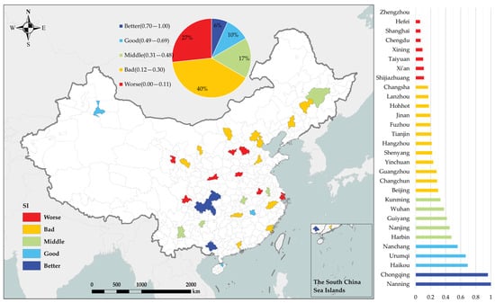
Figure 7.
State index map.
The comparison after initial weighting (Figure 8) shows that Nanning has a good natural climate and excels in terms of vegetation cover and water resources. This is inextricably linked to Nanning’s production base for tropical fruits, food, and cash crops. As a “mountain city” by the river, Chongqing also has an outstanding performance in terms of vegetation cover and water resources. Similarly, Haikou, a city located along the coast, is also characterized by its high vegetation coverage areas and water area indicators. Located in a tropical coastal area, Haikou is a popular tourist city. Thus, it is important to attach great importance to the development of tourism and the necessity to continue to improve environmental conditions. Other cities such as Wuhan, Nanjing, and Nanchang are also with outstanding performance in water resources because they are located close to the Yangtze River and with rich river and lake systems. On the contrary, Zhengzhou has performed poorly in all aspects. As the provincial capital of Henan Province, Zhengzhou rises as a railway transportation hub. It is located inland, with a typical temperate monsoon climate, four distinct seasons, insufficient rainfall, and textiles and pharmaceuticals as its main industries. Similar cities with low performance in the state index include Shijiazhuang, Taiyuan, Xi’an, Hefei, and Xining. Shanghai and Chengdu, as two cities with better geographic locations, have very poor performances in the state. Despite its limited spatial coverage, Shanghai is characterized by its rapid economic development. About 50% of the land in Shanghai is occupied by man-made buildings (houses, roads, structures, artificially excavated land, etc.), while the coverage of forest and grassland has been reduced to less than 20%. Despite its great internal greening construction, Shanghai’s further development has been severely constrained by natural resources. In comparison, another megacity, Beijing, has a broader developing space and potential. Chengdu faces a similar problem to the one Shanghai does, as its municipal districts have become highly urbanized. However, Chengdu has great geographic conditions and abundant natural resources, leading to its great development potential.
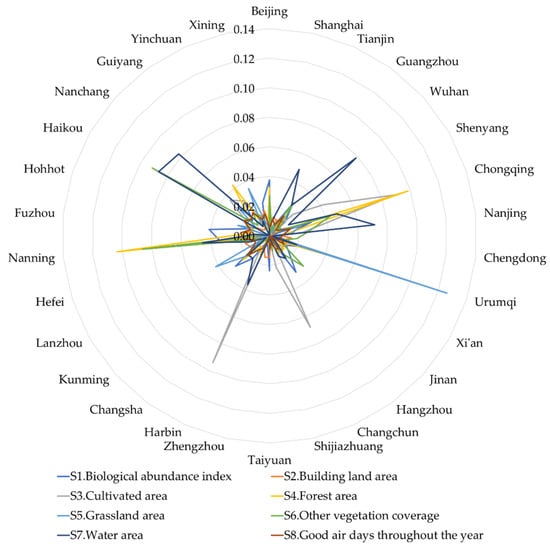
Figure 8.
Weighted comparison of sub-indicators in state index.
4.3. Response Index Analysis
From Figure 9, 25 (86.7%) provincial capital cities responded moderately to the deterioration of the environment. The response index map shows that the response index of Guiyang is much higher than those of other cities. Besides Guiyang, cities do not differ much in response index, which is explained in Figure 10. Guiyang has outstanding achievements in tree and grass planting and environmental protection investment. In particular, in terms of environmental protection investment, statistics show that Guiyang invested 83.233 billion yuan in water conservancy, environment, and public facility management in 2015, ranking fourth among the provincial capital cities, and it invested 20.67 billion yuan in agriculture, forestry, animal husbandry, and fishery, ranking fifth among the provincial capital cities. Note that Guiyang’s urban built-up area only covers 97.83 square kilometers (the second lowest in ranking, only 1/10 of the urban built-up area of Beijing). In megacities, such as Beijing, Shanghai, and Tianjin, with great environmental protection investment, the response indices are mostly medium and low because of several reasons. First, in the development of megacities, attention is often paid early to environmental issues. With the national attention on the environmental protection industry in recent years, the investment in provincial capitals tends to be stronger than those in several megacities. Second, the spatial coverage of megacities is much larger than that of other provincial capitals, leading to various investment quotas.
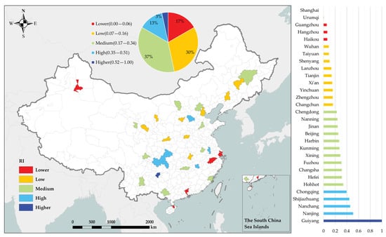
Figure 9.
Response index map.
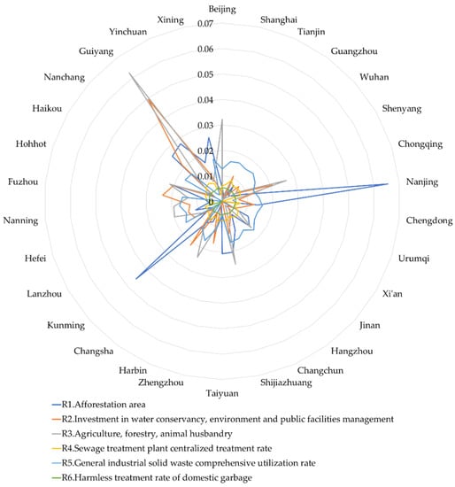
Figure 10.
Weighted comparison of sub-indicators in response index.
4.4. Analysis of UGEI
Figure 11 presents a relatively balanced distribution of the UGEI in the provincial capitals of China, with 3 cities having better and worse environmental quality, 14 with medium and good environmental quality, and 10 with bad environmental quality. The results suggest that Haikou, Nanning, Changsha, and Chongqing have better geographic environments, whereas Shijiazhuang, Zhengzhou, Taiyuan, and Shenyang have worse geographic environments.
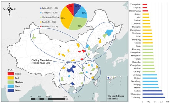
Figure 11.
UGEI distribution map of the provincial capitals in China. A, B, C, and D represent the four regions obtained from clustering. The blue elliptical cluster borders represent the geographic extent of each UGEI cluster.
The results of spatial clustering analysis show four distinct regions, namely, Region A, Region B, Region C, and Region D, according to the value of UGEI (Figure 11). Cities with poor environmental conditions are mainly distributed inland (D) to the west of the Qinling-Huaihe River Line. The environmental conditions in the eastern part of the Qinling-Huaihe River Line near the ocean are relatively good. Cities with good environmental conditions are mainly distributed in the south of the Qinling-Huaihe River Line (B, C). The revealed distribution patterns point to the great impact of climates on geographic environments.
Figure 12a,b show that the overall geographic environment of Region C is the best but with large discrepancies among cities. The geographic environment of Region D is the worst, but with small discrepancies among cities. The overall geographic environment of Region A and Region B is similar to the overall situation in China. From Figure 12c, we notice that the index value differences between cities in Region A are relatively small, and the environmental conditions in Beijing and Harbin are slightly better than those in the other four cities. Figure 12d shows that Nanjing and Nanchang in Region B have the best environmental conditions, while Shanghai, Fuzhou, and Hefei have poor environmental conditions. Figure 12e shows that cities in Region C can be further divided into two categories. The first category includes Chongqing, Nanning, Haikou, and Guiyang, where the environmental conditions are good; the other category includes Changsha, Kunming, Guangzhou, and Chengdu, where the environmental conditions are relatively poor compared to the cities in the first category. Figure 12e shows that Urumqi, Hohhot, Xi’an, and Yinchuan in Region D have relatively good environmental conditions, which are better than the other five cities in the region.
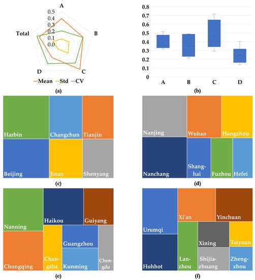
Figure 12.
Detailed statistics of UGEI for four regions (i.e., Regions A–D): (a) statistical results of UGEI, (b) boxplots of UGEI in Regions A, B, C, and D, (c) UGEI of cities in Region A, (d) UGEI of cities in Region B, (e) UGEI of cities in Region C, and (f) UGEI of cities in Region D.
5. Discussion
5.1. Different Types of Indicators
Urban built-up extent and population distribution are important indicators for measuring urban development. Current investigations on the evaluation of urban environmental sustainability mainly focus on the total indicators, per capita indicators, and area-averaged indicators. Most of the area-averaged indicators are based on administrative boundaries []. Taking GDP as an example, a city’s GDP is the original indicator, the per capita GDP is the per capita indicator, and the GDP divided by the size of administrative areas is the area-averaged indicator.
With intense human activities, cities differ in the levels of development and populations. Original indicators can be easily affected by the level of urban development, leading to biases towards developed cities, while the per capita indicators are subject to the population totals. Different from the original indicators and per capita indicators whose values are not fixed, urban built-up areas are naturally limited by land resources characterized by their upper-bounded nature. Thus, area-averaged indicators are able to evaluate the environmental conditions better than the original indicators and per capita indicators. The area-averaged indicators include indicators that use the urban administrative areas as the denominator, namely AAI, and the area- indicators that use the urban built-up areas as the denominator, namely UAI. The administrative areas are bounded by administrative boundaries that are artificially divided under the influence of various factors, such as history and policy. It can usually be considered fixed, and the division of administrative areas is not relevant to the development of the city. Politically based boundaries can be arbitrary and geographically irrelevant for evaluating sustainability []; therefore, they are not useful for sustainability assessments [,]. In addition to the administrative boundaries, various definitions and extracting methods of the urban built-up areas exist, such as definitions of population density, land cover types, and night-time light. Different definitions of urban built-up areas can largely affect the values of city sustainability indicators []. Remote sensing is an important way to monitor urban built-up areas. It is proved that the urban built-up areas extracted by high-resolution remote sensing imagery are more accurate than those extracted by low-resolution remote sensing imagery [].
5.2. Comparison and Validation
In UGEI, urban built-up extent serves as a common axe of evaluation for cities with diverse levels of development. In order to validate the effectiveness and reliability, we carry out a comparative analysis between the evaluation results of various indicators, namely area-averaged indicators, per capita indicators, and original indicators (or total indicators).
Among them, the evaluation result of the proposed index using urban built-up boundaries is UGEI, the evaluation result based on urban administrative area is UGEI-A, and the evaluation result of the population per capita is UGEI-P, and the result of the original indicators is UGEI-T. The urban built-up areas extracted from high-resolution remote sensing imagery, the administrative areas, and the total population of the city are shown in Figure 13. The relevant data can be found in Appendix A, Table A3.
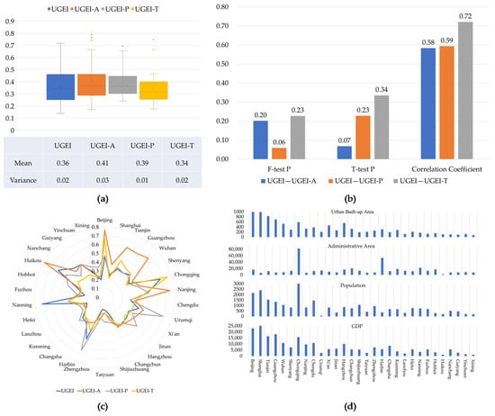
Figure 13.
Comparison of UGEI, UGEI-A, UGEI-P, and UGEI-T results: (a) Comparison of statistical indicators, (b) F-test, T-test and correlation coefficients, (c) Provincial city indicator results, (d) Urban area, administrative area, population and GDP of each city.
- (1)
- Analysis of reliability. From Figure 13a, we observe that the mean and variance of UGEI, UGEI-A, UGEI-P, and UGEI-T do not differ much. The proposed UGEI lies in the middle position, with the widest variance. In addition, UGEI is the only index with no outlier, indicating that UGEI is more stable and reliable compared with other indices. Figure 13b shows that the difference between UGEI and UGEI-A, UGEI-P, and UGEI-T is at the 0.05 level F-test and T-test is not significant. The F-test of UGEI and UGEI-P and the T-test result of UGEI and UGEI-A are close to 0.05, but the F-test and T-test results of UGEI and UGEI-T are higher than 0.05. The results indicate that UGEI is statistically similar to UGEI-A, UGEI-P, and UGEI-T, suggesting that our proposed UGEI does not deviate from other measurements, which proves the stability of our measurement. The correlation coefficients between UGEI and UGEI-A as well as UGEI-P and UGEI-T are greater than 0.5 but less than 0.8, revealing a statistically significant positive correlation between UGEI and the 3 indicators. The correlation coefficient between UGEI and UGEI-T is the largest. In general, we can conclude that the proposed UGEI complies with other measurements while reducing the occurrence of outliers.
- (2)
- Analysis of effectiveness. From Figure 13c, it can be seen that the evaluation results of UGEI, UGEI-A, UGEI-P, and UGEI-T in Beijing, Shanghai, Tianjin, Guangzhou, Wuhan, Nanjing, Haikou, Harbin, Chongqing, Urumqi, and Nanning are quite different. Based on the data presented in Figure 13d, it is apparent that Beijing, Shanghai, Tianjin, Guangzhou, Wuhan, and Nanjing are cities with high GDP, large urban built-up areas, small administrative areas, and large populations. The UGEI-A values for these cities are significantly higher than the UGEI, UGEI-P, and UGEI-T values. This indicates that the administrative area-based evaluation index is closely related to the overall level of urban development. Haikou’s high UGEI-A value can be attributed to its small administrative area. Conversely, Urumqi and Harbin have small populations and large administrative areas, namely, high per capita administrative areas, resulting in their UGEI-P values being higher than other indicators. This suggests that per capita indicators tend to favor cities with smaller urban population densities. Chongqing ranks first in terms of total urban population and administrative area, and its GDP and urban built-up area rank in the top five. Consequently, the UGEI-T value of Chongqing is the highest, and the UGEI value is second, both significantly higher than the UGEI-A and UGEI-P values. This indicates that the total indicators generally favor megacities and larger cities. Additionally, the proposed UGEI takes into account urban mass to a certain extent. Nanning is a city with medium GDP, population, administrative area, and urban built-up area. The proposed UGEI in Nanning is the highest. In contrast, Fuzhou, which is also a medium-level city, has the lowest UGEI value. Although the two cities have similar levels of development, the difference in UGEI values indicates that the UGEI index can effectively distinguish cities with the same level of development. Through our analysis of cities with different levels of development, we find that the use of other types of indicators would be influenced by the level of city development. However, our proposed UGEI index can effectively reduce the impact of a city’s development level on sustainable urban evaluation.
Furthermore, to validate the sustainability evaluation of the cities, an online survey was conducted with 387 participants. The volunteers included urban planners and environmental protection experts, college and graduate students, citizens and community residents, as well as professionals working in environmental protection organizations, urban planning, construction industries, etc. To avoid potential conflicts of interest, an anonymous approach was employed. Fifteen pairs of Chinese provincial cities were randomly selected, and volunteers were asked to judge which city in each pair had better environmental conditions. Participants were presented with pairs of cities and then asked to select which city they thought had better environmental conditions. The survey was conducted using an online questionnaire that was distributed to potential participants through social media platforms and email. The results of the survey indicated that UGEI had a success rate of at least 86%. In short, the proposed UGEI serves as an effective and reliable index, as the evaluation results are not affected by the level of urban economic development, people density, or predefined administrative areas.
6. Conclusions
Environmental concerns are critical for the development of urban areas. In this study, we propose UGEI, a comprehensive index that includes urban built-up areas extracted from high-resolution remote sensing images to evaluate urban sustainability. Unlike existing indices, which incorporate original, per capita, and area-averaged indicators, our index analyzes how different types of indicators affect urban sustainability values. We adopt a comprehensive weighting approach by using the AHP method to weigh high-level indicators and the entropy weighting method to weigh low-level indicators. Our research focuses on the provincial capital cities of China, and we verify the objectivity and reliability of the proposed UGEI. In conclusion, the proposed UGEI can serve as an effective tool for evaluating urban sustainability, and our findings can provide valuable guidance for future urban planning and environmental management. Our findings suggest that:
- Nearly half of China’s capital cities have poor environmental conditions and require further environmental protection measures to improve their quality. Among the selected cities, Nanning, Chongqing, and Haikou have the best environmental quality, while Zhengzhou, Taiyuan, and Shijiazhuang have the worst.
- The environmental conditions of China’s provincial capital cities can be divided into four regions, with the Qinling-Huaihe River Line serving as the boundary. The geographic environment of the provincial capitals in the southern region is better than that in the northern regions, while coastal cities in the northern regions have better environmental conditions than inland cities.
- Our evaluation results suggest that indices based on urban built-up areas extracted from high-resolution remote sensing imagery can accurately reflect environmental conditions and are not affected by varying levels of urban economic development, total population, and predefined administrative areas. Therefore, the proposed UGEI serves as an objective and reliable measurement of geographic environmental conditions.
UGEI is a valuable tool that connects urban development areas with urban sustainability. Through monitoring urban expansion and conducting sustainability assessments, UGEI can provide an early warning for unregulated urban development, as well as a critical reference for establishing the boundaries of scientifically planned urban development. Future research could focus on the following areas: (1) utilizing remote sensing and GIS data to track changes in land use and land cover as well as studying the impact of urban expansion on environmental sustainability; (2) validating its applicability in different environmental contexts and regions, especially for cross-country and cross-regional sustainability evaluations; (3) exploring its potential to be used in conjunction with other sustainability assessment tools; (4) and collaborating with stakeholders to promote the adoption of UGEI as a standard tool for sustainability evaluation. These efforts would ensure the effectiveness and reliability of UGEI across a wide range of environmental conditions and enable a more comprehensive and holistic approach to sustainability assessment.
Author Contributions
X.N.: Conceptualization, Methodology, Resources, Project administration, Funding acquisition. H.Z.: Methodology, Software, Formal analysis, Writing—Original Draft. Z.S.: Methodology, Investigation, Supervision. X.H.: Writing—Review and Editing, Validation. H.W.: Resources, Funding acquisition, Writing—Review and Editing. R.Z.: Data Curation, Visualization. M.H.: Validation, Writing—Review and Editing. All authors have read and agreed to the published version of the manuscript.
Funding
This work was supported by the Key Laboratory of Natural Resources Monitoring in Tropical and Subtropical Area of South China, Ministry of Natural Resources (No. 2022NRMZ01), Fundamental Research Funds for Chinese Academy of Surveying and Mapping (No. AR2201, No. AR2117), Training Project for Science and Technology Innovation Talents from the Ministry of Natural Resources of China (No.12110600000018003907).
Data Availability Statement
The panel data used in this study are obtained from https://data.stats.gov.cn, accessed on 26 February 2023.
Acknowledgments
We give sincere thanks to Lin Ding, You He and the anonymous reviewers for their valuable suggestions, who provided great help in improving our manuscript. Maps in this article were reviewed by Ministry of Natural Resources of the People’s Republic of China (GS(2016)1580).
Conflicts of Interest
The authors declare no conflict of interest.
Appendix A

Table A1.
The raw data of UGEI indicators.
Table A1.
The raw data of UGEI indicators.
| Cities | P1 | P2 | P3 | P4 | P5 | P6 | S1 | S2 | S3 | S4 | S5 | S6 | S7 | S8 | R1 | R2 | R3 | R4 | R5 | R6 |
|---|---|---|---|---|---|---|---|---|---|---|---|---|---|---|---|---|---|---|---|---|
| Beijing | 2171 | 3.01 | 20 | 710 | 16.42 | 16.41 | 0.31 | 2737 | 1274 | 9296 | 857 | 1568 | 302 | 186 | 29,503 | 586 | 1093 | 88 | 83 | 100 |
| Shanghai | 2415 | −1.27 | 32 | 1868 | 22.41 | 38.19 | 0.12 | 1922 | 1367 | 397 | 514 | 453 | 551 | 252 | 18,395 | 474 | 4 | 91 | 96 | 100 |
| Tianjin | 1547 | 0.23 | 47 | 1546 | 9.40 | 42.30 | 0.15 | 1871 | 2056 | 575 | 1255 | 215 | 1814 | 216 | 8865 | 1639 | 236 | 99 | 99 | 99 |
| Guangzhou | 1350 | 11.94 | 32 | 460 | 14.92 | 10.70 | 0.26 | 1303 | 594 | 2800 | 518 | 1135 | 806 | 312 | 27,200 | 415 | 34 | 92 | 95 | 95 |
| Wuhan | 1061 | 6.95 | 43 | 1334 | 8.32 | 26.69 | 0.19 | 1148 | 2618 | 1396 | 874 | 348 | 1834 | 189 | 11,796 | 861 | 41 | 95 | 98 | 100 |
| Shenyang | 829 | −1.58 | 45 | 692 | 5.97 | 27.87 | 0.11 | 992 | 2731 | 516 | 440 | 128 | 201 | 207 | 7282 | 351 | 75 | 95 | 92 | 100 |
| Chongqing | 3017 | 4.01 | 45 | 2828 | 11.41 | 86.17 | 0.27 | 2319 | 11558 | 16191 | 1982 | 1468 | 1253 | 292 | 25,657 | 2165 | 533 | 94 | 84 | 99 |
| Nanjing | 824 | 4.14 | 40 | 1426 | 9.50 | 28.40 | 0.18 | 1056 | 1733 | 1116 | 818 | 520 | 1053 | 231 | 88,910 | 419 | 47 | 64 | 91 | 100 |
| Chengdu | 1466 | 5.43 | 44 | 293 | 1.15 | 10.14 | 0.14 | 645 | 432 | 354 | 167 | 429 | 53 | 211 | 24,530 | 867 | 80 | 92 | 96 | 100 |
| Urumqi | 73 | 11.06 | 30 | 778 | 18.11 | 18.82 | 0.24 | 536 | 405 | 3159 | 3744 | 129 | 185 | 218 | 1853 | 305 | 9 | 84 | 90 | 96 |
| Xi’an | 816 | 4.64 | 39 | 236 | 6.21 | 16.34 | 0.18 | 901 | 1160 | 1017 | 311 | 282 | 53 | 250 | 25,640 | 485 | 117 | 92 | 91 | 98 |
| Jinan | 365 | 5.09 | 32 | 857 | 3.95 | 27.37 | 0.21 | 598 | 768 | 1059 | 226 | 481 | 81 | 124 | 17,561 | 163 | 142 | 96 | 99 | 100 |
| Hangzhou | 870 | 4.21 | 37 | 649 | 5.70 | 16.96 | 0.28 | 1029 | 511 | 2287 | 187 | 526 | 487 | 242 | 18,949 | 590 | 36 | 94 | 89 | 100 |
| Changchun | 753 | 2.15 | 55 | 388 | 3.03 | 25.01 | 0.13 | 717 | 4947 | 1160 | 356 | 60 | 234 | 237 | 18,927 | 480 | 52 | 90 | 97 | 100 |
| Shijiazhuang | 1070 | 5.88 | 38 | 1605 | 5.69 | 37.99 | 0.11 | 671 | 970 | 249 | 127 | 132 | 31 | 180 | 17,466 | 457 | 169 | 95 | 98 | 95 |
| Taiyuan | 432 | 3.40 | 37 | 2560 | 2.84 | 27.43 | 0.24 | 365 | 175 | 549 | 157 | 76 | 20 | 230 | 19,250 | 31 | 36 | 93 | 56 | 100 |
| Zhengzhou | 957 | 5.78 | 43 | 1548 | 4.81 | 25.29 | 0.14 | 433 | 112 | 182 | 91 | 77 | 46 | 136 | 3446 | 772 | 87 | 96 | 77 | 100 |
| Harbin | 387 | −0.20 | 34 | 461 | 4.09 | 39.83 | 0.14 | 814 | 6414 | 1489 | 709 | 137 | 506 | 227 | 13,514 | 311 | 255 | 90 | 100 | 92 |
| Changsha | 680 | 9.59 | 42 | 108 | 0.51 | 4.57 | 0.21 | 425 | 479 | 573 | 101 | 48 | 176 | 257 | 10,000 | 753 | 83 | 100 | 86 | 100 |
| Kunming | 668 | 5.98 | 41 | 2397 | 4.96 | 14.60 | 0.28 | 488 | 606 | 1997 | 880 | 175 | 249 | 350 | 52,300 | 255 | 36 | 92 | 36 | 93 |
| Lanzhou | 322 | 5.67 | 35 | 608 | 2.00 | 17.75 | 0.15 | 215 | 231 | 159 | 781 | 39 | 22 | 252 | 3562 | 287 | 40 | 89 | 98 | 20 |
| Hefei | 779 | 8.10 | 51 | 818 | 4.50 | 18.60 | 0.15 | 292 | 103 | 98 | 113 | 107 | 134 | 238 | 11,208 | 543 | 146 | 92 | 92 | 100 |
| Nanning | 740 | 6.04 | 39 | 257 | 4.05 | 9.73 | 0.29 | 586 | 2563 | 5043 | 287 | 852 | 353 | 324 | 5162 | 405 | 115 | 77 | 100 | 98 |
| Fuzhou | 678 | 10.67 | 35 | 602 | 3.57 | 21.42 | 0.33 | 187 | 28 | 579 | 73 | 35 | 62 | 344 | 4729 | 552 | 62 | 88 | 95 | 98 |
| Hohhot | 306 | 1.97 | 21 | 1165 | 1.05 | 22.83 | 0.19 | 340 | 541 | 519 | 543 | 14 | 11 | 276 | 14,077 | 560 | 117 | 92 | 33 | 100 |
| Haikou | 222 | 8.00 | 19 | 5 | 1.24 | 0.39 | 0.21 | 227 | 437 | 623 | 194 | 586 | 432 | 349 | 2419 | 79 | 19 | 92 | 100 | 100 |
| Nanchang | 523 | 6.93 | 51 | 240 | 4.65 | 6.86 | 0.19 | 331 | 875 | 558 | 474 | 73 | 396 | 311 | 12,290 | 411 | 44 | 98 | 97 | 100 |
| Guiyang | 462 | 5.25 | 34 | 1201 | 2.60 | 16.07 | 0.27 | 308 | 634 | 1170 | 163 | 109 | 37 | 340 | 11,531 | 832 | 207 | 99 | 48 | 95 |
| Yinchuan | 216 | 0.06 | 38 | 803 | 1.57 | 16.25 | 0.15 | 270 | 409 | 208 | 660 | 115 | 67 | 259 | 9460 | 270 | 38 | 94 | 44 | 100 |
| Xining | 201 | 4.91 | 41 | 470 | 0.74 | 19.28 | 0.23 | 111 | 27 | 157 | 109 | 11 | 4 | 295 | 9154 | 88 | 38 | 74 | 100 | 95 |
Note: P1 is expressed in ten thousand individuals; P2 and P3 are represented as %; P4 and P6 are measured in ten thousand tons; P5 is denoted in billion tons; S1 is a dimensionless quantity; S2-S7 are expressed in square kilometers; S8 is quantified in astronomical units; R1 is measured in hectares; R2 and R3 are represented in hundred million yuan; R4, R5, and R6 are expressed as %. For the purpose of displaying the overall performance in the table, only the integer part of the data was retained for all indicators except for P2, P5, P6, and S1. However, accurate data were used for calculating these indicators.

Table A2.
The weighted data of UGEI indicators by entropy weight method.
Table A2.
The weighted data of UGEI indicators by entropy weight method.
| Cities | P1 | P2 | P3 | P4 | P5 | P6 | S1 | S2 | S3 | S4 | S5 | S6 | S7 | S8 | R1 | R2 | R3 | R4 | R5 | R6 |
|---|---|---|---|---|---|---|---|---|---|---|---|---|---|---|---|---|---|---|---|---|
| Beijing | 0.85 | 0.90 | 0.03 | 0.30 | 0.78 | 0.22 | 3.76 | 0.78 | 0.49 | 3.26 | 0.38 | 2.69 | 0.59 | 0.55 | 0.53 | 0.26 | 3.22 | 0.60 | 1.27 | 0.53 |
| Shanghai | 0.96 | 0.06 | 0.76 | 0.84 | 1.13 | 0.59 | 0.15 | 1.32 | 0.54 | 0.00 | 0.13 | 0.66 | 1.17 | 1.14 | 0.25 | 0.20 | 0.00 | 0.68 | 1.59 | 0.53 |
| Tianjin | 0.69 | 0.35 | 1.65 | 0.82 | 0.49 | 0.79 | 0.76 | 1.12 | 1.04 | 0.11 | 0.85 | 0.30 | 4.91 | 0.82 | 0.05 | 1.07 | 0.82 | 0.89 | 1.65 | 0.52 |
| Guangzhou | 0.73 | 2.64 | 0.75 | 0.28 | 1.05 | 0.20 | 2.69 | 1.37 | 0.30 | 1.31 | 0.29 | 2.77 | 2.55 | 1.67 | 0.77 | 0.26 | 0.13 | 0.71 | 1.57 | 0.50 |
| Wuhan | 0.76 | 1.66 | 1.44 | 1.12 | 0.74 | 0.79 | 1.43 | 1.17 | 2.18 | 0.81 | 0.95 | 1.02 | 7.87 | 0.58 | 0.34 | 0.87 | 0.21 | 0.79 | 1.64 | 0.53 |
| Shenyang | 1.14 | 0.00 | 1.57 | 1.05 | 1.00 | 1.53 | 0.09 | 0.36 | 4.19 | 0.49 | 0.84 | 0.63 | 1.47 | 0.74 | 0.41 | 0.62 | 0.74 | 0.79 | 1.49 | 0.53 |
| Chongqing | 2.19 | 1.09 | 1.57 | 2.15 | 0.94 | 2.38 | 2.95 | 0.00 | 8.91 | 9.83 | 2.18 | 4.33 | 4.79 | 1.49 | 0.88 | 2.08 | 2.64 | 0.75 | 1.30 | 0.52 |
| Nanjing | 0.97 | 1.12 | 1.27 | 1.91 | 1.45 | 1.36 | 1.27 | 0.52 | 2.28 | 1.07 | 1.52 | 2.64 | 7.14 | 0.95 | 6.54 | 0.65 | 0.41 | 0.00 | 1.45 | 0.53 |
| Chengdu | 1.60 | 1.37 | 1.49 | 0.33 | 0.02 | 0.39 | 0.52 | 1.49 | 0.42 | 0.19 | 0.07 | 1.86 | 0.21 | 0.77 | 1.41 | 1.25 | 0.60 | 0.71 | 1.59 | 0.53 |
| Urumqi | 0.00 | 2.47 | 0.65 | 1.66 | 4.69 | 1.44 | 2.44 | 0.92 | 0.79 | 5.32 | 12.59 | 0.94 | 1.92 | 0.83 | 0.00 | 0.77 | 0.12 | 0.51 | 1.45 | 0.50 |
| Xi’an | 0.65 | 1.21 | 1.19 | 0.21 | 0.61 | 0.53 | 1.29 | 1.32 | 1.05 | 0.65 | 0.24 | 0.93 | 0.15 | 1.12 | 1.18 | 0.53 | 0.73 | 0.70 | 1.46 | 0.52 |
| Jinan | 0.47 | 1.30 | 0.76 | 1.43 | 0.68 | 1.65 | 1.80 | 1.13 | 1.22 | 1.29 | 0.37 | 3.08 | 0.58 | 0.00 | 1.45 | 0.27 | 1.55 | 0.81 | 1.67 | 0.53 |
| Hangzhou | 0.56 | 1.13 | 1.08 | 0.51 | 0.43 | 0.45 | 3.05 | 1.39 | 0.32 | 1.34 | 0.00 | 1.53 | 1.90 | 1.05 | 0.64 | 0.54 | 0.18 | 0.77 | 1.40 | 0.53 |
| Changchun | 0.89 | 0.73 | 2.17 | 0.51 | 0.37 | 1.21 | 0.40 | 1.17 | 6.79 | 1.13 | 0.53 | 0.16 | 1.52 | 1.00 | 1.24 | 0.77 | 0.45 | 0.66 | 1.60 | 0.53 |
| Shijiazhuang | 2.35 | 1.46 | 1.12 | 3.67 | 1.48 | 3.17 | 0.00 | 0.34 | 2.17 | 0.31 | 0.22 | 1.05 | 0.26 | 0.50 | 2.04 | 1.28 | 2.52 | 0.80 | 1.64 | 0.50 |
| Taiyuan | 0.77 | 0.97 | 1.04 | 5.38 | 0.60 | 2.08 | 2.37 | 1.48 | 0.28 | 0.78 | 0.29 | 0.48 | 0.10 | 0.94 | 2.06 | 0.00 | 0.48 | 0.74 | 0.58 | 0.53 |
| Zhengzhou | 1.55 | 1.44 | 1.46 | 2.70 | 0.90 | 1.58 | 0.64 | 1.49 | 0.11 | 0.11 | 0.01 | 0.37 | 0.30 | 0.11 | 0.12 | 1.68 | 0.99 | 0.81 | 1.12 | 0.53 |
| Harbin | 0.41 | 0.27 | 0.88 | 0.65 | 0.59 | 2.08 | 0.48 | 0.87 | 9.39 | 1.59 | 1.40 | 0.63 | 3.64 | 0.91 | 0.88 | 0.50 | 2.40 | 0.66 | 1.68 | 0.48 |
| Changsha | 1.40 | 2.18 | 1.38 | 0.22 | 0.00 | 0.32 | 1.91 | 1.21 | 1.00 | 0.89 | 0.12 | 0.27 | 1.90 | 1.18 | 1.04 | 2.13 | 1.21 | 0.91 | 1.34 | 0.53 |
| Kunming | 0.94 | 1.47 | 1.29 | 3.87 | 0.85 | 0.82 | 3.07 | 1.45 | 0.90 | 2.46 | 2.03 | 0.97 | 1.94 | 2.01 | 4.56 | 0.45 | 0.37 | 0.71 | 0.08 | 0.49 |
| Lanzhou | 1.01 | 1.41 | 0.93 | 2.15 | 0.74 | 2.29 | 0.72 | 1.48 | 0.74 | 0.31 | 4.20 | 0.39 | 0.28 | 1.14 | 0.49 | 1.25 | 0.91 | 0.63 | 1.65 | 0.00 |
| Hefei | 1.50 | 1.89 | 1.92 | 1.69 | 1.02 | 1.38 | 0.68 | 1.71 | 0.12 | 0.02 | 0.14 | 0.73 | 1.32 | 1.01 | 1.10 | 1.39 | 1.97 | 0.71 | 1.48 | 0.53 |
| Nanning | 1.79 | 1.49 | 1.18 | 0.65 | 1.16 | 0.87 | 3.36 | 0.38 | 6.64 | 10.34 | 0.94 | 8.63 | 4.55 | 1.77 | 0.53 | 1.28 | 1.92 | 0.32 | 1.69 | 0.52 |
| Fuzhou | 2.18 | 2.39 | 0.92 | 2.02 | 1.36 | 2.63 | 4.10 | 1.68 | 0.00 | 1.43 | 0.15 | 0.31 | 0.97 | 1.95 | 0.68 | 2.35 | 1.36 | 0.61 | 1.57 | 0.52 |
| Hohhot | 0.74 | 0.69 | 0.09 | 3.33 | 0.23 | 2.37 | 1.50 | 1.17 | 1.49 | 1.05 | 2.25 | 0.00 | 0.05 | 1.35 | 2.06 | 2.01 | 2.18 | 0.70 | 0.00 | 0.53 |
| Haikou | 0.74 | 1.87 | 0.00 | 0.00 | 0.47 | 0.00 | 1.84 | 1.28 | 1.67 | 1.85 | 0.99 | 9.15 | 8.66 | 2.00 | 0.32 | 0.33 | 0.49 | 0.71 | 1.69 | 0.53 |
| Nanchang | 2.05 | 1.66 | 1.94 | 0.98 | 2.25 | 1.00 | 1.54 | 0.59 | 3.59 | 1.72 | 2.89 | 1.05 | 8.26 | 1.66 | 2.65 | 2.14 | 1.17 | 0.86 | 1.62 | 0.53 |
| Guiyang | 2.02 | 1.33 | 0.91 | 5.56 | 1.35 | 2.70 | 2.91 | 0.51 | 2.90 | 4.22 | 0.96 | 1.86 | 0.77 | 1.92 | 2.79 | 4.95 | 6.23 | 0.88 | 0.38 | 0.50 |
| Yinchuan | 0.62 | 0.32 | 1.15 | 2.82 | 0.54 | 2.07 | 0.71 | 1.21 | 1.38 | 0.45 | 3.48 | 1.46 | 1.09 | 1.20 | 1.66 | 1.16 | 0.86 | 0.76 | 0.28 | 0.53 |
| Xining | 0.94 | 1.27 | 1.32 | 2.51 | 0.35 | 3.79 | 2.26 | 1.73 | 0.05 | 0.53 | 0.70 | 0.07 | 0.00 | 1.52 | 2.56 | 0.53 | 1.31 | 0.26 | 1.69 | 0.50 |
Note: To display the overall performance in the table, all indicators have been multiplied by 100 and rounded to 2 decimal places, while accurate data have been used in their calculation.

Table A3.
Different types of indicators and supplementary data.
Table A3.
Different types of indicators and supplementary data.
| Cities | UGEI | UGEI-A | UGEI-P | UGEI-T | UBA | AA | Population | GDP |
|---|---|---|---|---|---|---|---|---|
| Beijing | 0.46 | 0.76 | 0.47 | 0.66 | 997.90 | 16,411.00 | 2170.50 | 23,014.59 |
| Shanghai | 0.25 | 0.38 | 0.27 | 0.22 | 992.33 | 6341.00 | 2415.27 | 25,123.45 |
| Tianjin | 0.35 | 0.62 | 0.37 | 0.45 | 836.26 | 11,917.00 | 1546.95 | 16,538.19 |
| Guangzhou | 0.34 | 0.62 | 0.35 | 0.41 | 702.16 | 7434.00 | 1350.11 | 18,100.41 |
| Wuhan | 0.38 | 0.66 | 0.36 | 0.40 | 532.01 | 8569.00 | 1060.77 | 10,905.60 |
| Shenyang | 0.31 | 0.36 | 0.30 | 0.28 | 294.56 | 12,860.00 | 829.10 | 7272.31 |
| Chongqing | 0.66 | 0.42 | 0.39 | 0.75 | 592.62 | 82,375.00 | 3016.55 | 15,717.27 |
| Nanjing | 0.49 | 0.74 | 0.50 | 0.46 | 336.42 | 6587.00 | 823.59 | 9720.77 |
| Chengdu | 0.29 | 0.35 | 0.29 | 0.34 | 385.13 | 12,121.00 | 1465.75 | 10,801.16 |
| Urumqi | 0.40 | 0.46 | 0.69 | 0.34 | 210.94 | 13,788.00 | 73.11 | 2631.64 |
| Xi’an | 0.31 | 0.42 | 0.36 | 0.34 | 466.84 | 10,097.00 | 815.66 | 5801.20 |
| Jinan | 0.34 | 0.39 | 0.49 | 0.31 | 269.11 | 7998.00 | 364.54 | 6100.23 |
| Hangzhou | 0.35 | 0.37 | 0.36 | 0.37 | 562.13 | 16,596.00 | 870.04 | 10,050.21 |
| Changchun | 0.37 | 0.36 | 0.35 | 0.33 | 331.82 | 20,594.00 | 753.40 | 5530.03 |
| Shijiazhuang | 0.18 | 0.26 | 0.29 | 0.22 | 197.37 | 13,056.00 | 1070.16 | 5440.60 |
| Taiyuan | 0.14 | 0.17 | 0.28 | 0.18 | 215.39 | 6988.00 | 431.87 | 2735.34 |
| Zhengzhou | 0.14 | 0.24 | 0.24 | 0.19 | 258.86 | 7446.00 | 956.90 | 7311.52 |
| Harbin | 0.51 | 0.31 | 0.66 | 0.41 | 312.24 | 53,100.00 | 387.08 | 5751.21 |
| Changsha | 0.35 | 0.35 | 0.33 | 0.32 | 201.61 | 11,816.00 | 680.36 | 8510.13 |
| Kunming | 0.34 | 0.31 | 0.39 | 0.31 | 280.02 | 18,419.00 | 667.70 | 3968.01 |
| Lanzhou | 0.24 | 0.25 | 0.28 | 0.25 | 127.18 | 13086.00 | 321.90 | 2095.99 |
| Hefei | 0.21 | 0.25 | 0.30 | 0.24 | 217.35 | 11,445.00 | 779.00 | 5660.27 |
| Nanning | 0.72 | 0.42 | 0.42 | 0.42 | 175.61 | 22,235.00 | 740.23 | 3410.09 |
| Fuzhou | 0.23 | 0.30 | 0.31 | 0.27 | 133.90 | 12,675.00 | 678.36 | 5618.08 |
| Hohhot | 0.32 | 0.28 | 0.44 | 0.28 | 157.93 | 17,186.00 | 306.00 | 3090.52 |
| Haikou | 0.61 | 0.79 | 0.51 | 0.35 | 114.02 | 2304.00 | 222.30 | 1161.96 |
| Nanchang | 0.49 | 0.44 | 0.36 | 0.31 | 109.52 | 7402.00 | 522.79 | 5618.08 |
| Guiyang | 0.46 | 0.46 | 0.46 | 0.31 | 97.83 | 8043.00 | 462.18 | 2891.16 |
| Yinchuan | 0.30 | 0.29 | 0.38 | 0.26 | 128.30 | 9025.00 | 216.41 | 1493.86 |
| Xining | 0.20 | 0.23 | 0.35 | 0.25 | 84.23 | 7660.00 | 201.35 | 1131.62 |
UBA: Urban Built-up Area; AA: Administrative Area. The unit of measurement for UBA and AA is square kilometers. The unit for population is ten thousand people. The unit for GDP is hundred million yuan.
References
- Zhou, M.; Lu, L.; Guo, H.; Weng, Q.; Cao, S.; Zhang, S.; Li, Q. Urban Sprawl and Changes in Land-Use Efficiency in the Beijing–Tianjin–Hebei Region, China from 2000 to 2020: A Spatiotemporal Analysis Using Earth Observation Data. Remote Sens. 2021, 13, 2850. [Google Scholar] [CrossRef]
- Bathrellos, G.D.; Skilodimou, H.D.; Chousianitis, K.; Youssef, A.M.; Pradhan, B. Suitability estimation for urban development using multi-hazard assessment map. Sci. Total Environ. 2017, 575, 119–134. [Google Scholar] [CrossRef] [PubMed]
- Li, D.; Shan, J.; Shao, Z.; Zhou, X.; Yao, Y. Geomatics for smart cities-concept, key techniques, and applications. Geo-Spat. Inf. Sci. 2013, 16, 13–24. [Google Scholar] [CrossRef]
- Wang, X.R.; Hui, C.M.; Choguill, C.; Jia, S.H. The new urbanization policy in China: Which way forward? Habitat Int. 2015, 47, 279–284. [Google Scholar] [CrossRef]
- Lu, X.-H.; Ke, S.-G. Evaluating the effectiveness of sustainable urban land use in China from the perspective of sustainable urbanization. Habitat Int. 2018, 77, 90–98. [Google Scholar] [CrossRef]
- Li, H.L.; Peng, J.; Liu, Y.X.; Hu, Y.N. Urbanization impact on landscape patterns in Beijing City, China: A spatial heterogeneity perspective. Ecol. Indic. 2017, 82, 50–60. [Google Scholar] [CrossRef]
- Zhou, X.; Chen, H. Impact of urbanization-related land use land cover changes and urban morphology changes on the urban heat island phenomenon. Sci. Total Environ. 2018, 635, 1467–1476. [Google Scholar] [CrossRef]
- Dahl, A.L. Agenda 21. Glob. Environ. Chang. 2014, 1, 527–531. [Google Scholar] [CrossRef]
- Chen, H.-S. The establishment and application of environment sustainability evaluation indicators for ecotourism environments. Sustainability 2015, 7, 4727–4746. [Google Scholar] [CrossRef]
- Hsu, A.; Lloyd, A.; Emerson, J.W. What progress have we made since Rio? Results from the 2012 Environmental Performance Index (EPI) and Pilot Trend EPI. Environ. Sci. Policy 2013, 33, 171–185. [Google Scholar] [CrossRef]
- Lucena-Moya, P.; Pardo, I. An invertebrate multimetric index to classify the ecological status of small coastal lagoons in the Mediterranean ecoregion (MIBIIN). Mar. Freshw. Res. 2012, 63, 801–814. [Google Scholar] [CrossRef]
- Singh, R.K.; Murty, H.R.; Gupta, S.K.; Dikshit, A.K. An overview of sustainability assessment methodologies. Ecol. Indic. 2009, 9, 189–212. [Google Scholar] [CrossRef]
- Cifrian, E.; Andres, A.; Viguri, J.R. Developing a regional environmental information system based on macro-level waste indicators. Ecol. Indic. 2015, 53, 258–270. [Google Scholar] [CrossRef]
- Park, S.; Howden, M.; Crimp, S. Informing regional level policy development and actions for increased adaptive capacity in rural livelihoods. Environ. Sci. Policy 2012, 15, 23–37. [Google Scholar] [CrossRef]
- Yue, D.X.; Zeng, J.J.; Chao, Y.; Zou, M.L.; Kai, L.; Chen, G.G.; Guo, J.J.; Xu, X.F.; Meng, X.M. Ecological risk assessment of the Gannan Plateau, northeastern Tibetan Plateau. J. Mt. Sci. 2018, 15, 105–118. [Google Scholar] [CrossRef]
- Alwi, S.R.W.; Manan, Z.A.; Klemeš, J.J.; Huisingh, D. Sustainability engineering for the future. J. Clean. Prod. 2014, 71, 1–10. [Google Scholar] [CrossRef]
- Estrada, M.A.R.; Park, D. The Application of the Gross City Development Index (GCD-Index) in Tokyo, Japan. Econ. Anal. Policy 2019, 62, 37–46. [Google Scholar] [CrossRef]
- Pereira, D.V.E.S.; Mota, C.M.D.M. Human development index based on ELECTRE TRI-C multicriteria method: An application in the city of Recife. Soc. Indic. Res. 2016, 125, 19–45. [Google Scholar] [CrossRef]
- Collen, B.; Loh, J.; Whitmee, S.; Mcrae, L.; Amin, R.; Jem, B. Monitoring change in vertebrate abundance: The Living Planet Index. Conserv. Biol. 2010, 23, 317–327. [Google Scholar] [CrossRef]
- López-Ruiz, V.-R.; Alfaro-Navarro, J.-L.; Nevado-Peña, D. Knowledge-city index construction: An intellectual capital perspective. Expert Syst. Appl. 2014, 41, 5560–5572. [Google Scholar] [CrossRef]
- Meijering, J.V.; Kern, K.; Tobi, H. Identifying the methodological characteristics of European green city rankings. Ecol. Indic. 2014, 43, 132–142. [Google Scholar] [CrossRef]
- Fu, W.; Turner, J.C.; Zhao, J.; Du, G. Ecological footprint (EF): An expanded role in calculating resource productivity (RP) using China and the G20 member countries as examples. Ecol. Indic. 2015, 48, 464–471. [Google Scholar] [CrossRef]
- Herva, M.; Roca, E. Ranking municipal solid waste treatment alternatives based on ecological footprint and multi-criteria analysis. Ecol. Indic. 2013, 25, 77–84. [Google Scholar] [CrossRef]
- Silalertruksa, T.; Gheewala, S.H.; Pongpat, P. Sustainability assessment of sugarcane biorefinery and molasses ethanol production in Thailand using eco-efficiency indicator. Appl. Energy 2015, 160, 603–609. [Google Scholar] [CrossRef]
- Uchiyama, Y.; Mori, K. Methods for specifying spatial boundaries of cities in the world: The impacts of delineation methods on city sustainability indices. Sci. Total Environ. 2017, 592, 345–356. [Google Scholar] [CrossRef] [PubMed]
- Christenson, E.; Bain, R.; Wright, J.; Aondoakaa, S.; Hossain, R.; Bartram, J. Examining the influence of urban definition when assessing relative safety of drinking-water in Nigeria. Sci. Total Environ. 2014, 490, 301–312. [Google Scholar] [CrossRef]
- Shen, X.; Shao, Z.; Tian, Y. Built-up areas extraction of high-resolution remote sensing images by texture driven visual attention mechanism. Acta Geod. Cartogr. Sin. 2014, 43, 842–847. [Google Scholar]
- Mori, K.; Christodoulou, A. Review of sustainability indices and indicators: Towards a new City Sustainability Index (CSI). Environ. Impact Assess. Rev. 2012, 32, 94–106. [Google Scholar] [CrossRef]
- Michael, F.L.; Noor, Z.Z.; Figueroa, M.J. Review of urban sustainability indicators assessment—Case study between Asian countries. Habitat Int. 2014, 44, 491–500. [Google Scholar] [CrossRef]
- Yigitcanlar, T.; Dur, F.; Dizdaroglu, D. Towards prosperous sustainable cities: A multiscalar urban sustainability assessment approach. Habitat Int. 2015, 45, 36–46. [Google Scholar] [CrossRef]
- Ding, L.; Shao, Z.; Zhang, H.; Xu, C.; Wu, D. A comprehensive evaluation of urban sustainable development in China based on the TOPSIS-Entropy method. Sustainability 2016, 8, 746. [Google Scholar] [CrossRef]
- Mansour, S.; Ghoneim, E.; El-Kersh, A.; Said, S.; Abdelnaby, S. Spatiotemporal Monitoring of Urban Sprawl in a Coastal City Using GIS-Based Markov Chain and Artificial Neural Network (ANN). Remote Sens. 2023, 15, 601. [Google Scholar] [CrossRef]
- Kut, P.; Pietrucha-Urbanik, K. Most Searched Topics in the Scientific Literature on Failures in Photovoltaic Installations. Energies 2022, 15, 8108. [Google Scholar] [CrossRef]
- Koko, A.F.; Han, Z.; Wu, Y.; Abubakar, G.A.; Bello, M. Spatiotemporal Land Use/Land Cover Mapping and Prediction Based on Hybrid Modeling Approach: A Case Study of Kano Metropolis, Nigeria (2020–2050). Remote Sens. 2022, 14, 6083. [Google Scholar] [CrossRef]
- Mu, B.; Zhao, X.; Zhao, J.; Liu, N.; Si, L.; Wang, Q.; Sun, N.; Sun, M.; Guo, Y.; Zhao, S. Quantitatively Assessing the Impact of Driving Factors on Vegetation Cover Change in China’s 32 Major Cities. Remote Sens. 2022, 14, 839. [Google Scholar] [CrossRef]
- Yuan, Y.; Wen, Q.; Zhao, X.; Liu, S.; Zhu, K.; Hu, B. Identifying Grassland Distribution in a Mountainous Region in Southwest China Using Multi-Source Remote Sensing Images. Remote Sens. 2022, 14, 1472. [Google Scholar] [CrossRef]
- Shen, L.; Kyllo, J.M.; Guo, X. An integrated model based on a hierarchical indices system for monitoring and evaluating urban sustainability. Sustainability 2013, 5, 524–559. [Google Scholar] [CrossRef]
- Shen, L.Y.; Ochoa, J.J.; Shah, M.N.; Zhang, X. The application of urban sustainability indicators—A comparison between various practices. Habitat Int. 2011, 35, 17–29. [Google Scholar] [CrossRef]
- Liu, Y.; Ye, Q.; Li, J.; Kong, X.; Jiao, L. Suitability evaluation of rural settlements based on accessibility of production and living: A case study of tingzu town in Hubei province of China. Chin. Geogr. Sci. 2016, 26, 550–565. [Google Scholar] [CrossRef]
- Chen, C.; Han, J.; Fan, P. Measuring the level of industrial green development and exploring its influencing factors: Empirical evidence from China’s 30 provinces. Sustainability 2016, 8, 153. [Google Scholar] [CrossRef]
- Uuemaa, E.; Mander, Ü.; Marja, R. Trends in the use of landscape spatial metrics as landscape indicators: A review. Ecol. Indic. 2013, 28, 100–106. [Google Scholar] [CrossRef]
- Koschke, L.; Fürst, C.; Frank, S.; Makeschin, F. A multi-criteria approach for an integrated land-cover-based assessment of ecosystem services provision to support landscape planning. Ecol. Indic. 2012, 21, 54–66. [Google Scholar] [CrossRef]
- Thivierge, M.-N.; Parent, D.; Bélanger, V.; Angers, D.A.; Allard, G.; Pellerin, D.; Vanasse, A. Environmental sustainability indicators for cash-crop farms in Quebec, Canada: A participatory approach. Ecol. Indic. 2014, 45, 677–686. [Google Scholar] [CrossRef]
- Boyle, P.; Hayes, M.; Gormally, M.; Sullivan, C.; Moran, J. Development of a nature value index for pastoral farmland—A rapid farm-level assessment. Ecol. Indic. 2015, 56, 31–40. [Google Scholar] [CrossRef]
- Li, L.; Lu, H.; Tilley, D.R.; Ren, H.; Shen, W. The maximum empower principle: An invisible hand controlling the self-organizing development of forest plantations in south China. Ecol. Indic. 2013, 29, 278–292. [Google Scholar] [CrossRef]
- Kotwal, P.C.; Omprakash, M.D.; Gairola, S.; Dugaya, D. Ecological indicators: Imperative to sustainable forest management. Ecol. Indic. 2008, 8, 104–107. [Google Scholar] [CrossRef]
- Yuan, X.; Mu, R.; Zuo, J.; Wang, Q. Economic development, energy consumption, and air pollution: A critical assessment in China. Hum. Ecol. Risk Assess. Int. J. 2015, 21, 781–798. [Google Scholar] [CrossRef]
- Ji, J.; Tang, Z.; Jiang, L.; Sheng, T.; Zhao, F.; Zhang, R.; Shifaw, E.; Liu, W.; Li, H.; Liu, X.; et al. Study on Regional Eco-Environmental Quality Evaluation Considering Land Surface and Season Differences: A Case Study of Zhaotong City. Remote Sens. 2023, 15, 657. [Google Scholar] [CrossRef]
- Tchórzewska-Cieślak, B.; Pietrucha-Urbanik, K. Water System Safety Analysis Model. Energies 2023, 16, 2809. [Google Scholar] [CrossRef]
- Li, Z.; Lu, Y.; Yang, X. Multi-Level Dynamic Analysis of Landscape Patterns of Chinese Megacities during the Period of 2016–2021 Based on a Spatiotemporal Land-Cover Classification Model Using High-Resolution Satellite Imagery: A Case Study of Beijing, China. Remote Sens. 2022, 15, 74. [Google Scholar] [CrossRef]
- Mansour, S.; Alahmadi, M.; Atkinson, P.M.; Dewan, A. Forecasting of Built-Up Land Expansion in a Desert Urban Environment. Remote Sens. 2022, 14, 2037. [Google Scholar] [CrossRef]
- Fiala, N. Measuring sustainability: Why the ecological footprint is bad economics and bad environmental science. Ecol. Econ. 2008, 67, 519–525. [Google Scholar] [CrossRef]
- Graymore, M.L.M.; Sipe, N.G.; Rickson, R.E. Sustaining Human Carrying Capacity: A tool for regional sustainability assessment. Ecol. Econ. 2010, 69, 459–468. [Google Scholar] [CrossRef]
- Zhang, H.; Ning, X.; Shao, Z.; Wang, H. Spatiotemporal Pattern Analysis of China’s Cities Based on High-Resolution Imagery from 2000 to 2015. ISPRS Int. J. Geo-Inf. 2019, 8, 241. [Google Scholar] [CrossRef]
Disclaimer/Publisher’s Note: The statements, opinions and data contained in all publications are solely those of the individual author(s) and contributor(s) and not of MDPI and/or the editor(s). MDPI and/or the editor(s) disclaim responsibility for any injury to people or property resulting from any ideas, methods, instructions or products referred to in the content. |
© 2023 by the authors. Licensee MDPI, Basel, Switzerland. This article is an open access article distributed under the terms and conditions of the Creative Commons Attribution (CC BY) license (https://creativecommons.org/licenses/by/4.0/).