


Analysis of the Rockfall Phenomena Contributing to the Evolution of a Pocket Beach Area Using Traditional and Remotely Acquired Data (Lo Zingaro Nature Reserve, Southern Italy)

 ,
,  and
and 
Abstract
1. Introduction
2. Materials and Methods
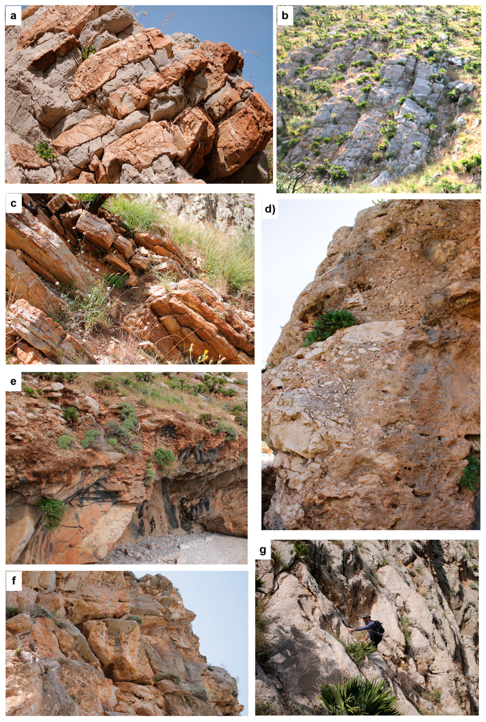
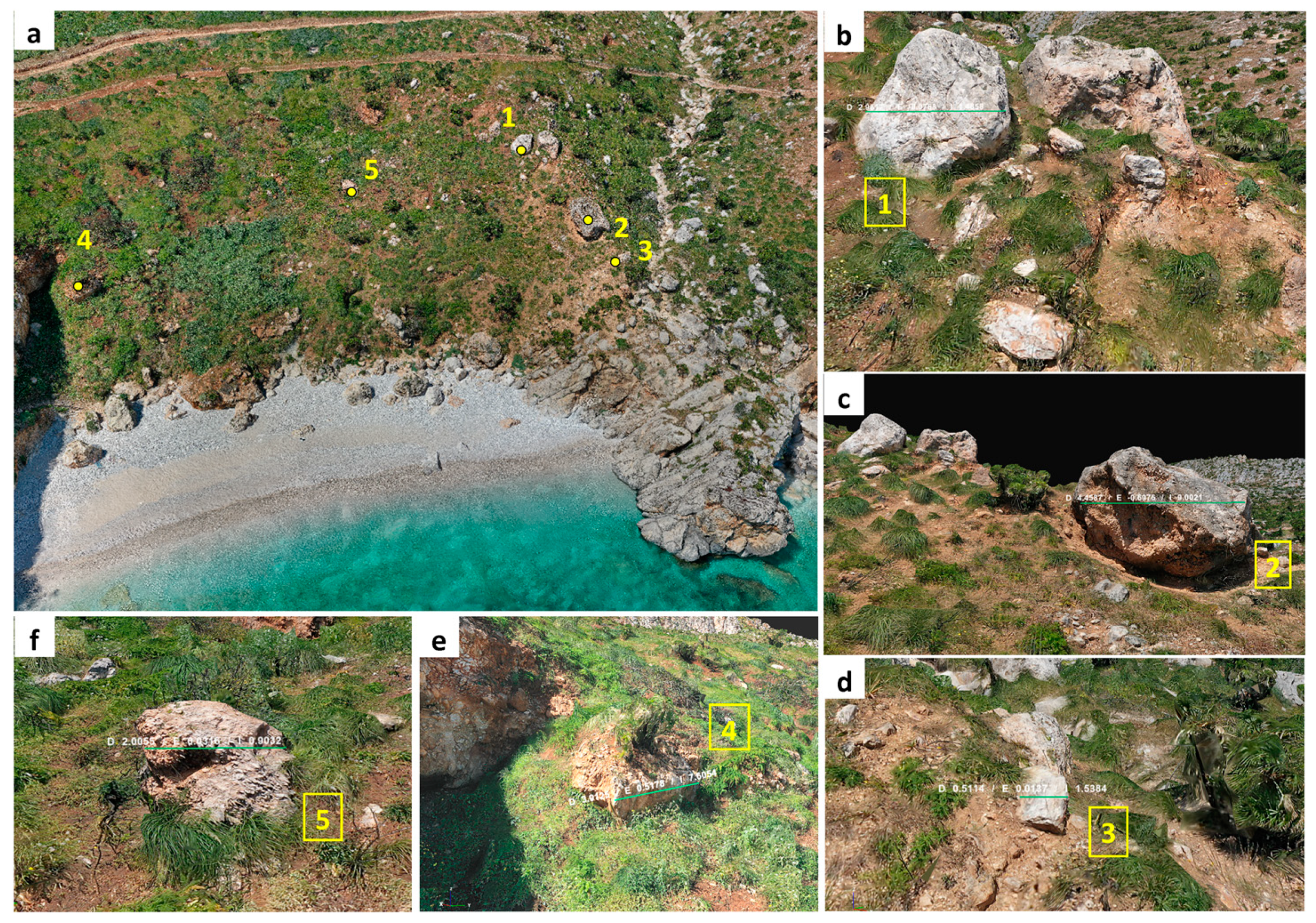
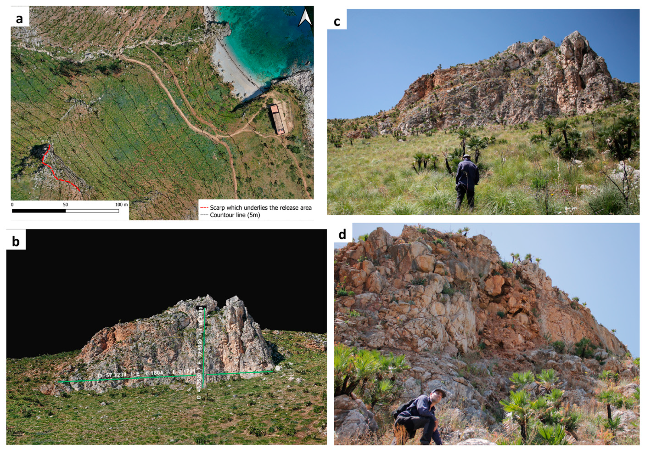
2.1. General and Detailed Setting of the Study Area
2.2. Slope Analysis
3. Results and Discussion
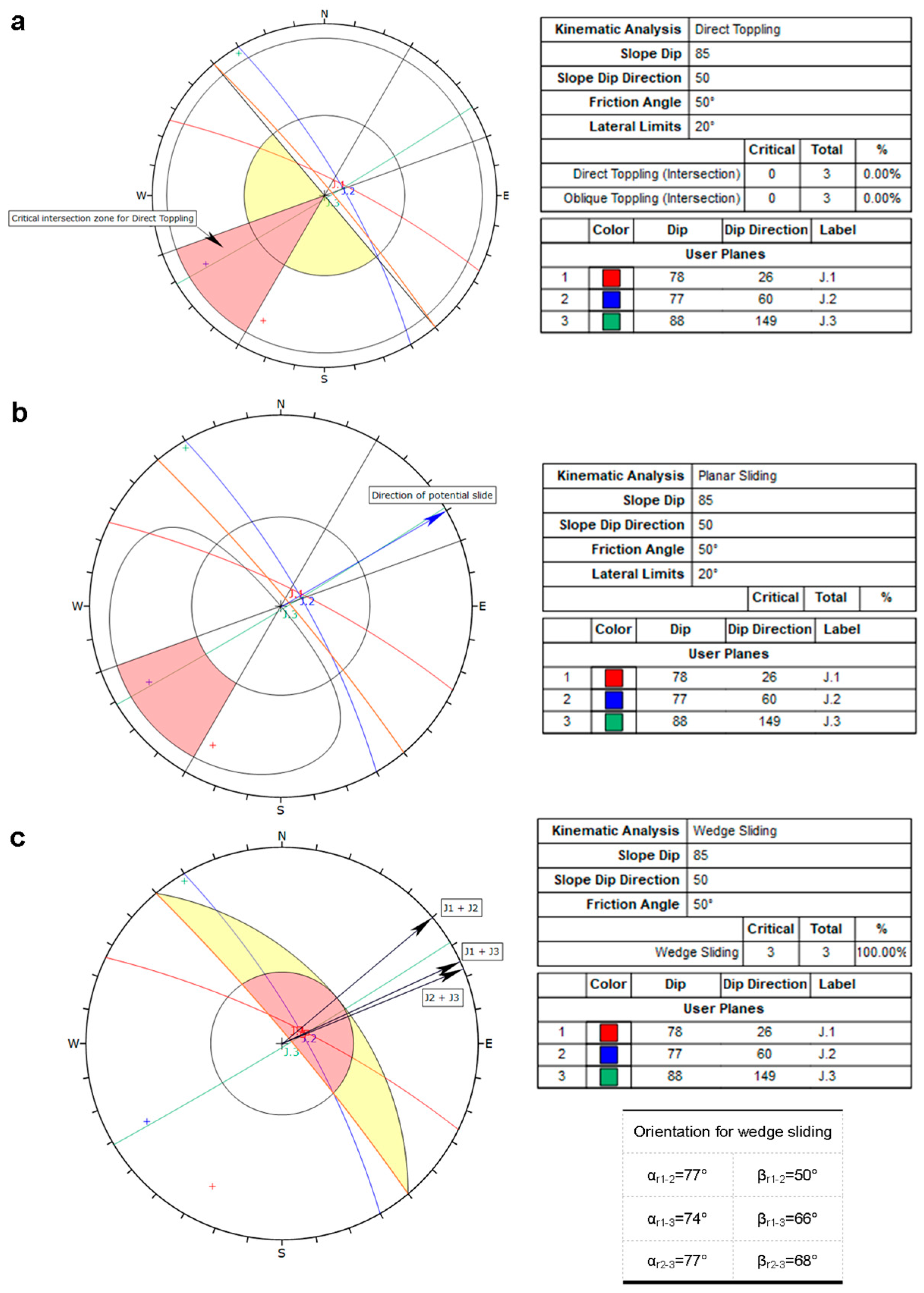
3.1. Traditional and Remote-Sensing-Based Approaches for Geostructural Characterization
3.2. Empirical and Analytical Models
4. Conclusions
Author Contributions
Funding
Data Availability Statement
Conflicts of Interest
References
- Caracausi, A.; Sulli, A. Outgassing of Mantle Volatiles in Compressional Tectonic Regime Away From Volcanism: The Role of Continental Delamination. Geochem. Geophys. Geosyst. 2019, 20, 2007–2020. [Google Scholar] [CrossRef]
- Vandelli, V.; Sarkar, N.; Micallef, A.S.; Soldati, M.; Rizzo, A. Coastal Inundation Scenarios in the North-Eastern Sector of the Island of Gozo (Malta, Mediterranean Sea) as a Response to Sea Level Rise. J. Maps 2022, 1–10. [Google Scholar] [CrossRef]
- Sarkar, N.; Rizzo, A.; Vandelli, V.; Soldati, M. A Literature Review of Climate-Related Coastal Risks in the Mediterranean, a Climate Change Hotspot. Sustainability 2022, 14, 15994. [Google Scholar] [CrossRef]
- Randazzo, G.; Barreca, G.; Cascio, M.; Crupi, A.; Fontana, M.; Gregorio, F.; Lanza, S.; Muzirafuti, A. Analysis of Very High Spatial Resolution Images for Automatic Shoreline Extraction and Satellite-Derived Bathymetry Mapping. Geosciences 2020, 10, 172. [Google Scholar] [CrossRef]
- Randazzo, G.; Lanza, S. Regional Plan against Coastal Erosion: A Conceptual Model for Sicily. Land 2020, 9, 307. [Google Scholar] [CrossRef]
- Pappalardo, G.; Mineo, S.; Cappadonia, C.; Martire, D.D.; Calcaterra, D.; Tammaro, U.; Rotigliano, E.; Agnesi, V. A combined GNSS-DINSAR-IRT study for the characterization of a deep-seated gravitational slope deformation. Ital. J. Eng. Geol. Environ. 2021, 1, 151–162. [Google Scholar] [CrossRef]
- Cafiso, F.; Cappadonia, C. Landslide Inventory and Rockfall Risk Assessment of a Strategic Urban Area (Palermo, Sicily). Rend. Online Soc. Geol. Ital. 2019, 48, 96–105. [Google Scholar] [CrossRef]
- Cappadonia, C.; Cafiso, F.; Ferraro, R.; Martinello, C.; Rotigliano, E. Rockfall Hazards of Mount Pellegrino Area (Sicily, Southern Italy). J. Maps 2021, 17, 29–39. [Google Scholar] [CrossRef]
- Cafiso, F.; Cappadonia, C.; Ferraro, R.; Martinello, C. Rockfall Hazard Assessment of the Monte Gallo Oriented Nature Reserve Area (Southern Italy). In Proceedings of the IOP Conference Series: Earth and Environmental Science, Turin, Italy, 20–25 September 2021; Volume 833. [Google Scholar]
- Dignan, J.; Micallef, A.; Mueller, C.; Sulli, A.; Zizzo, E.; Spatola, D. A Scenario-Based Assessment of the Tsunami Hazard in Palermo, Northern Sicily, and the Southern Tyrrhenian Sea. Geol. Soc. Lond. Spec. Publ. 2020, 500, 63–80. [Google Scholar] [CrossRef]
- Violante, C. Rocky Coast: Geological Constraints for Hazard Assessment. Geol. Soc. Lond. Spec. Publ. 2009, 322, 1–31. [Google Scholar] [CrossRef]
- Randazzo, G.; Italiano, F.; Micallef, A.; Tomasello, A.; Cassetti, F.P.; Zammit, A.; D’Amico, S.; Saliba, O.; Cascio, M.; Cavallaro, F.; et al. WebGIS Implementation for Dynamic Mapping and Visualization of Coastal Geospatial Data: A Case Study of BESS Project. Appl. Sci. 2021, 11, 8233. [Google Scholar] [CrossRef]
- Yann, B.; Rémi, B.; Merour, A.; Riotte, C. Evolution of Corsican Pocket Beaches. J. Coast. Res. 2014, 70, 96–101. [Google Scholar] [CrossRef]
- Dai, Z.-J.; Liu, J.T.; Lei, Y.-P.; Zhang, X.-L. Patterns of Sediment Transport Pathways on a Headland Bay Beach—Nanwan Beach, South China: A Case Study. J. Coast. Res. 2010, 26, 1096–1103. [Google Scholar] [CrossRef]
- Auflič, M.J.; Herrera, G.; Mateos, R.M.; Poyiadji, E.; Quental, L.; Severine, B.; Peternel, T.; Podolszki, L.; Calcaterra, S.; Kociu, A.; et al. Landslide Monitoring Techniques in the Geological Surveys of Europe. Landslides 2023, 1–15. [Google Scholar] [CrossRef]
- Pappalardo, G.; Mineo, S.; Imposa, S.; Grassi, S.; Leotta, A.; La Rosa, F.; Salerno, D. A Quick Combined Approach for the Characterization of a Cliff during a Post-Rockfall Emergency. Landslides 2020, 17, 1063–1081. [Google Scholar] [CrossRef]
- Devoto, S.; Macovaz, V.; Mantovani, M.; Soldati, M.; Furlani, S. Advantages of Using UAV Digital Photogrammetry in the Study of Slow-Moving Coastal Landslides. Remote Sens. 2020, 12, 3566. [Google Scholar] [CrossRef]
- Mateos, R.M.; Ezquerro, P.; Azañón, J.M.; Gelabert, B.; Herrera, G.; Fernández-Merodo, J.A.; Spizzichino, D.; Sarro, R.; García-Moreno, I.; Béjar-Pizarro, M. Coastal Lateral Spreading in the World Heritage Site of the Tramuntana Range (Majorca, Spain). The Use of PSInSAR Monitoring to Identify Vulnerability. Landslides 2018, 15, 797–809. [Google Scholar] [CrossRef]
- Demurtas, V.; Orrù, P.E.; Deiana, G. Evolution of Deep-Seated Gravitational Slope Deformations in Relation with Uplift and Fluvial Capture Processes in Central Eastern Sardinia (Italy). Land 2021, 10, 1193. [Google Scholar] [CrossRef]
- Mateos, R.M.; Azañón, J.M.; Roldán, F.J.; Notti, D.; Pérez-Peña, V.; Galve, J.P.; Pérez-García, J.L.; Colomo, C.M.; Gómez-López, J.M.; Montserrat, O.; et al. The Combined Use of PSInSAR and UAV Photogrammetry Techniques for the Analysis of the Kinematics of a Coastal Landslide Affecting an Urban Area (SE Spain). Landslides 2017, 14, 743–754. [Google Scholar] [CrossRef]
- Mineo, S.; Caliò, D.; Pappalardo, G. UAV-Based Photogrammetry and Infrared Thermography Applied to Rock Mass Survey for Geomechanical Purposes. Remote Sens. 2022, 14, 473. [Google Scholar] [CrossRef]
- Francioni, M.; Salvini, R.; Stead, D.; Coggan, J. Improvements in the Integration of Remote Sensing and Rock Slope Modelling. Nat. Hazards 2018, 90, 975–1004. [Google Scholar] [CrossRef]
- Riquelme, A.; Cano, M.; Tomás, R.; Abellán, A. Identification of Rock Slope Discontinuity Sets from Laser Scanner and Photogrammetric Point Clouds: A Comparative Analysis. Procedia Eng. 2017, 191, 838–845. [Google Scholar] [CrossRef]
- Riquelme, A.J.; Abellán, A.; Tomás, R.; Jaboyedoff, M. A New Approach for Semi-Automatic Rock Mass Joints Recognition from 3D Point Clouds. Comput. Geosci. 2014, 68, 38–52. [Google Scholar] [CrossRef]
- Riquelme, A.J.; Abellán, A.; Tomás, R. Discontinuity Spacing Analysis in Rock Masses Using 3D Point Clouds. Eng. Geol. 2015, 195, 185–195. [Google Scholar] [CrossRef]
- Crosta, G.B.; Agliardi, F.; Frattini, P.; Lari, S. Key Issues in Rock Fall Modeling, Hazard and Risk Assessment for Rockfall Protection. In Engineering Geology for Society and Territory—Volume 2; Lollino, G., Giordan, D., Crosta, G.B., Corominas, J., Azzam, R., Wasowski, J., Eds.; Springer International Publishing: Cham, Switzerland, 2015; pp. 43–58. ISBN 978-3-319-09056-6. [Google Scholar]
- Martinello, C.; Cappadonia, C.; Conoscenti, C.; Rotigliano, E. Landform Classification: A High-Performing Mapping Unit Partitioning Tool for Landslide Susceptibility Assessment—A Test in the Imera River Basin (Northern Sicily, Italy). Landslides 2022, 19, 539–553. [Google Scholar] [CrossRef]
- Guzzetti, F.; Reichenbach, P.; Ardizzone, F.; Cardinali, M.; Galli, M. Estimating the Quality of Landslide Susceptibility Models. Geomorphology 2006, 81, 166–184. [Google Scholar] [CrossRef]
- Rotigliano, E.; Agnesi, V.; Cappadonia, C.; Conoscenti, C. The Role of the Diagnostic Areas in the Assessment of Landslide Susceptibility Models: A Test in the Sicilian Chain. Nat. Hazards 2011, 58, 981–999. [Google Scholar] [CrossRef]
- Martinello, C.; Cappadonia, C.; Conoscenti, C.; Agnesi, V.; Rotigliano, E. Optimal Slope Units Partitioning in Landslide Susceptibility Mapping. J. Maps 2021, 17, 152–162. [Google Scholar] [CrossRef]
- Evans, S.G.; Hungr, O. The Assessment of Rockfall Hazard at the Base of Talus Slopes. Can. Geotech. J. 1993, 30, 620–636. [Google Scholar] [CrossRef]
- Corominas, J. The Angle of Reach as a Mobility Index for Small and Large Landslides. Can. Geotech. J. 1996, 33, 260–271. [Google Scholar] [CrossRef]
- Piteau, D.R.; Clayton, R. Computer Rockfall Model. In Proceedings of the Meeting on Rockfall Dynamics and Protective Works Effectiveness, Bergamo, Italy, 20–21 May 1976; ISMES Publication: Bergamo, Italy, 1976; pp. 123–125. [Google Scholar]
- Regione Siciliana—Assessorato del Territorio e dell’Ambiente—Area 2 Interdipartimentale—Nodo Regionale S.I.T.R Modello Digitale del Terreno (MDT) 2 m Volo ATA 2012. 2013. Available online: https://www.sitr.regione.sicilia.it/geoportale/it/metadata/details/947 (accessed on 15 December 2022).
- 3dFlow—3DF Zephyr. User Manual. 2013. Available online: http://3dflow.net/zephyr-doc/3DF%20Zephyr%20Manual%204.300%20English.pdf (accessed on 15 December 2022).
- QGIS.Org, %Y. QGIS Geographic Information System. QGIS Association. Available online: http://www.Qgis.Org (accessed on 15 December 2022).
- Conrad, O.; Bechtel, B.; Bock, M.; Dietrich, H.; Fischer, E.; Gerlitz, L.; Wehberg, J.; Wichmann, V.; Böhner, J. System for Automated Geoscientific Analyses (SAGA) v. 2.1.4. Geosci. Model Dev. 2015, 8, 1991–2007. [Google Scholar] [CrossRef]
- IS GeoMassi—IS GM Software. Available online: https://www.Cdmdolmen.It/Prodotti/Isgm.Htm (accessed on 15 December 2022).
- Catalano, R.; Valenti, V.; Albanese, C.; Accaino, F.; Sulli, A.; Tinivella, U.; Gasparo Morticelli, M.; Zanolla, C.; Giustiniani, M. Sicily’s Fold–Thrust Belt and Slab Roll-Back: The SI.RI.PRO. Seismic Crustal Transect. J. Geol. Soc. 2013, 170, 451–464. [Google Scholar] [CrossRef]
- Sulli, A.; Agate, M.; Zizzo, E.; Gasparo Morticelli, M.; Lo Iacono, C. Geo-Hazards of the San Vito Peninsula Offshore (Southwestern Tyrrhenian Sea). J. Maps 2021, 17, 185–196. [Google Scholar] [CrossRef]
- Agate, M.; Basilone, L.; Di Maggio, C.; Contino, A.; Pierini, S.; Catalano, R. Quaternary Marine and Continental Unconformity-Bounded Stratigraphic Units of the NW Sicily Coastal Belt. J. Maps 2017, 13, 425–437. [Google Scholar] [CrossRef]
- ISRM Suggested Methods for the Quantitative Description of Discontinuities in Rock Masses. Int. J. Rock Mech. Min. Sci. Geomech. 1978, 15, 319–368.
- Dips v.8.021 Graphical and Statistical Analysis of Orientation Data. Available online: https://www.rocscience.com/support/dips/release-notes (accessed on 15 December 2022).
- Robiati, C.; Mastrantoni, G.; Francioni, M.; Eyre, M.; Coggan, J.; Mazzanti, P. Contribution of High-Resolution Virtual Outcrop Models for the Definition of Rockfall Activity and Associated Hazard Modelling. Land 2023, 12, 191. [Google Scholar] [CrossRef]
- Regione Siciliana. Assessorato Territorio e Ambiente. ARTA “Direttive per la Redazione degli Studi di Valutazione della Pericolosità Derivante da Fenomeni di Crollo”; Regione Siciliana. Assessorato Territorio e Ambiente, ARTA: Palermo, Italy, 2013. [Google Scholar]
- Hoek, E.; Bray, J.W. Rock Slope Engineering, 3rd ed.; The Institution of Mining and Metallurgy: London, UK, 1981. [Google Scholar]
- Crosta, G.B.; Agliardi, F. A Methodology for Physically Based Rockfall Hazard Assessment. Nat. Hazards Earth Syst. Sci. 2003, 3, 407–422. [Google Scholar] [CrossRef]
- Wichmann, V. The Gravitational Process Path (GPP) Model (v1.0)—A GIS-Based Simulation Framework for Gravitational Processes. Geosci. Model Dev. 2017, 10, 3309–3327. [Google Scholar] [CrossRef]
- Hudson, J.A.; Harrison, J.P. Engineering Rock Mechanics: An Introduction to the Principles; Repr.; Pergamon: Oxford, UK, 2007; ISBN 978-0-08-043864-1. [Google Scholar]
- Markland, J.T. A Useful Technique for Estimating the Stability of Rock Slopes When the Rigid Wedge Slide Type of Failure Is Expected; Imperial College of Science and Technology: London, UK, 1972. [Google Scholar]
- Goodman, R.E. Methods of Geological Engineering in Discontinuous Rocks; West Publishing, Co.: St. Paul, MN, USA, 1976; ISBN 978-0-8299-0066-8. [Google Scholar]


| Slope Material | Kn | Kt | Cr |
|---|---|---|---|
| Talus cover | |||
| 0.45 | 0.85 | 0.50 | |
| Clean hard rock | |||
| 0.60 | 0.85 | 0.40 | |
Disclaimer/Publisher’s Note: The statements, opinions and data contained in all publications are solely those of the individual author(s) and contributor(s) and not of MDPI and/or the editor(s). MDPI and/or the editor(s) disclaim responsibility for any injury to people or property resulting from any ideas, methods, instructions or products referred to in the content. |
© 2023 by the authors. Licensee MDPI, Basel, Switzerland. This article is an open access article distributed under the terms and conditions of the Creative Commons Attribution (CC BY) license (https://creativecommons.org/licenses/by/4.0/).
Share and Cite
Cappadonia, C.; Cafiso, F.; Ferraro, R.; Martinello, C.; Rotigliano, E. Analysis of the Rockfall Phenomena Contributing to the Evolution of a Pocket Beach Area Using Traditional and Remotely Acquired Data (Lo Zingaro Nature Reserve, Southern Italy). Remote Sens. 2023, 15, 1401. https://doi.org/10.3390/rs15051401
Cappadonia C, Cafiso F, Ferraro R, Martinello C, Rotigliano E. Analysis of the Rockfall Phenomena Contributing to the Evolution of a Pocket Beach Area Using Traditional and Remotely Acquired Data (Lo Zingaro Nature Reserve, Southern Italy). Remote Sensing. 2023; 15(5):1401. https://doi.org/10.3390/rs15051401
Chicago/Turabian StyleCappadonia, Chiara, Fabio Cafiso, Riccardo Ferraro, Chiara Martinello, and Edoardo Rotigliano. 2023. "Analysis of the Rockfall Phenomena Contributing to the Evolution of a Pocket Beach Area Using Traditional and Remotely Acquired Data (Lo Zingaro Nature Reserve, Southern Italy)" Remote Sensing 15, no. 5: 1401. https://doi.org/10.3390/rs15051401
APA StyleCappadonia, C., Cafiso, F., Ferraro, R., Martinello, C., & Rotigliano, E. (2023). Analysis of the Rockfall Phenomena Contributing to the Evolution of a Pocket Beach Area Using Traditional and Remotely Acquired Data (Lo Zingaro Nature Reserve, Southern Italy). Remote Sensing, 15(5), 1401. https://doi.org/10.3390/rs15051401