Communication

A Multi-Sensor Satellite Approach to Characterize the Volcanic Deposits Emitted during Etna’s Lava Fountaining: The 2020–2022 Study Case

Istituto Nazionale di Geofisica e Vulcanologia, Osservatorio Etneo, 95125 Catania, Italy
*
Author to whom correspondence should be addressed.
Remote Sens. 2023, 15(4), 916; https://doi.org/10.3390/rs15040916
Submission received: 3 January 2023 / Revised: 3 February 2023 / Accepted: 6 February 2023 / Published: 7 February 2023

Abstract

:
Between December 2020 and February 2022, the South East Crater of Etna has been the source of numerous eruptions, mostly characterized by the emission of lava fountains, pyroclastic material and short-lasting lava flows. Here we estimate the volume and distribution of the lava deposits by elaborating multi-source satellite imagery. SEVIRI data have been elaborated using CL-HOTSAT to estimate the lava volume emitted during each event and calculate the cumulative volume; Pléiades and WorldView-1 data have been used to derive Digital Surface Models, whose differences provide thickness distributions and hence volumes of the volcanic deposits. We find a good agreement, with the total average lava volume obtained by SEVIRI reaching 73.2 × 10⁶ m3 and the one from optical data amounting to 67.7 × 10⁶ m3. This proves the robustness of both techniques and the accuracy of the volume estimates, which provide important information on the lava flooding history and evolution of the volcano.

1. Introduction

In the last decade, Mt Etna (Italy) showed intense volcanic activity at the four summit craters, Voragine (VOR), Bocca Nuova (BN), North East Crater (NEC) and South East Crater (SEC). Periods of long-lasting and low energy Strombolian activity, usually accompanied by emission of lava flows at low output rates from vents located at base of summit craters [1,2,3,4], have been alternated by sequences of short-lasting paroxysmal events, as observed during the 2011–2013 years at SEC [5,6,7] and during 2015–2016 at VOR [8,9,10]. The summit activity was temporarily interrupted only by the 2018 eruption [11,12].
The resumed weak Strombolian activity persisted for almost two years and, again, shifted toward more energetic manifestations, with a new sequence of paroxysmal eruptions starting in December 2020 [3,13,14,15]. From December 2020 to February 2022, more than 60 episodes of ash-rich lava fountaining have taken place at the South East Crater (SEC) with the formation of sustained eruptive columns several kilometers high (up to 11 km a.s.l.) [3,13,14,16], combined with rheomorphic lava flows emplaced for distances of some kilometers from the same crater during each event. This new paroxysmal sequence showed an extraordinary regular periodicity of occurrence in February-April 2021, with one event every 30–50 h. Then, in the second phase between May and July 2021, the time gap between two events was even shorter (10–15 h).
Paroxysmal eruptions are among the most hazardous volcanic phenomena at the summit of Mt Etna, due to the markedly higher output rates of both tephra and lavas emitted in a short time, compared to the lower energetic events of lava flow output. Moreover, the fast growing of the SEC caused by the accumulation of proximal pyroclastic deposits poses the potential of hazard of crater’s sector collapse, which in turn may generate pyroclastic avalanches as recently observed [17,18,19,20]. The main hazard posed by paroxysmal summit eruptions comes from powerful tephra ejection and consequent hot avalanches emplacement, which provide an unpredictable threat to visitors, estimated to be around one million per year. In addition, fine ash in the atmosphere can be extremely dangerous for air traffic, causing severe damage to aircraft jet engines [21]. Once the ash falls on the ground, it causes damage to agriculture, viability, roof stability and human health [22,23]. Conversely, lava flows from summit craters may primarily cause damages to the touristic infrastructures located above 1800 m of elevation [24].
Estimating the distribution and volume of volcanic products emitted during a paroxysm is important to improve knowledge about magma supply, storage, and transport, as well as to derive input data, and calibrate and validate numerical models for hazard assessment [25]. In addition, keeping track of the erupted volume over time allows for the estimation of the state of the volcano and the volume of lava that could be erupted in the future [26,27]. In order to quantify volcanic products and map morphological variations, different techniques have been developed that use various source data acquisition methods, including LIDAR, laser scanner, photogrammetry from ground, airborne and unmanned aerial vehicles (UAVs, see, e.g., [28,29]). However, these techniques are often impractical both in remotely-located volcanoes, and at the summit area of active volcanoes that is often extremely windy and subject to high-risk phenomena. Another issue is the need for frequent updates in vast areas that make the use of these techniques very difficult and expensive.
The technological advancements and increasing availability of high-resolution satellite imagery have recently offered the potential for more frequent and accurate estimates. In particular, infrared remote sensing data have been proven to be an effective means to derive the lava volume in near real time [30,31,32,33]. At the Istituto Nazionale di Geofisica e Vulcanologia (INGV) in Catania, the CL-HOTSAT thermal monitoring system has been designed and implemented in OpenCL standard for parallel computing for the near-real-time monitoring of high-temperature volcanic features using multispectral infrared observations carried out by different satellite sensors (e.g., MODIS, SEVIRI, VIIRS, SLSTR) [34,35]. In case of eruptions, CL-HOTSAT provides radiant heat flux curves and effusion rate estimates computing the lava discharge rate from the heat radiated per unit time by the surface of active lava flows. Erupted lava flow volumes can be estimated by integrating the satellite-derived effusion rates in case of effusive eruptions [30,32,36], or by modelling the cooling phase of radiant heat flux curves for short lived eruptions, such as lava fountains [37,38,39].
Another ever-growing means for space-based measurements of volcanic deposits is the exploitation of very high-resolution optical satellite images acquired in stereo or tri-stereo. By processing these satellite data and applying photogrammetry techniques, the three-dimensional model of any target area on the Earth’s surface can be reconstructed [40]. Recently developed satellite sensors (e.g., Pleiades, WorldView, Skysat) are able to acquire images at sub-metric spatial resolution and the processing of such images produces one-meter digital surface models (DSM). Depending on the acquisition geometry, different levels of accuracy can be reached; from comparison with ground-based measurements in steep regions such as Mt Etna, a vertical accuracy below 1 m can be reached for most of the points [41]. Due to the frequent and rapid changes in the morphology of active volcanoes, and because of objective difficulties to use other techniques, such as airborne or UAVs [42,43], optical satellite data is often the only way to update the topography at Mt Etna. From the comparison of multiple DSMs, thickness and extent of volcanic deposits can be determined. Due to the intrinsic accuracy of the techniques only deposits with thickness above 1 m can be measured, moreover the thickest the deposits with minor areal extension, the higher the accuracy of volume measurement.
Here we report for the first time the volumes of lava flows erupted during each single paroxysmal event that occurred at Etna from December 2020 to February 2022 and provide cumulative volumes of selected time windows by using exclusively multi-sensor satellite images. In particular, we used SEVIRI data to estimate the radiant heat flux and hence the lava flow volume obtained from the modeling of the radiant heat flux curve [32], thus providing quantitative information about the different eruptive phases of the summit activity. Moreover, the cumulative volumes estimated from SEVIRI images are compared with the volumes derived by the thickness distribution of volcanic deposits retrieved by differencing successive digital topographies. These topographies were produced using three Pléiades triplets (acquired on 22 August 2020, 26 February 2021 and 29 June 2022) and a stereo pair WorldView-1 of 27 July 2021 and permitted also to quantify and evaluate the rapid growth of the SEC cone. In this way we provide satellite-based estimates of lava volumes that exploit the information redundancy coming from the integration of different kinds of satellite data, reducing the total uncertainty and thus allowing for more reliable assessments.

2. Satellite Data

Two kinds of satellite images were used in this study: high temporal low spatial multispectral SEVIRI data and on demand very high spatial resolution optical Pléiades and WorldView data. SEVIRI data were used to measure the radiative power of volcanic thermal features so as to follow the fast dynamic of the paroxysmal episodes and characterize each single event, while optical data were processed to constrain and quantify the volcanic deposits.
The Spinning Enhanced Visible and InfraRed Imager (SEVIRI) sensor, on board Meteosat Second Generation geostationary satellites, acquires data every 15 min (3 km spatial resolution at nadir) in twelve wavebands, including one in the middle infrared MIR (band IR3.9, 3.48–4.36 µm) and two in the thermal infrared TIR (band IR12.0, 11.00–13.00, and band IR13.4, 12.40–14.40 µm) that are particularly useful in detecting and tracking hot spots associated with fires and effusive activity [44,45]. Thanks to the high frequency of acquisition, it is also the most suitable space-based instrument for observing short-lived events such as lava fountains [37,38,39].
Pléiades satellite images are acquired at 50 cm spatial resolution by two identical satellites the Pléiades 1A and Pléiades 1B with a 20 km swath, flying in Sun-synchronous orbits with 98.2° inclination and an offset of 180° from each other, allowing for a minimum revisit time of 24 h [46]. This system of satellites is very agile and is capable of acquiring, on demand with the One Tasking Services, three or more nearly synchronous images of the same area with a stereo angle varying between ~6° and ~28°. This ability to capture, from a single stereoscopic pair, a sequence of up to 25 images, allows for 3D automatic extraction of the Earth’s surface, enhancing the quality and the completeness of automatically extracted 3D maps [47].
Worldview-1, launched on 18 September 2007 and operational since November 2007, was the first half-meter resolution commercial imaging satellite in the world to provide imagery of Earth more accurately than its forerunner, the QuickBird satellite, and it is able to provide stereo scenes. The satellite operates at an altitude of 496 km along a Sun-synchronous orbit, with an inclination of 97.7° and a revisit time of 1.7 days at 1 m GSD (Ground Sampling Distance) and 4.6 days at around half meter GSD. Worldview-1 carries a panchromatic imaging system providing in-track stereo images of target areas by rotating along its axis (nominally maximal +/−45° off-nadir).

3. Materials and Methods
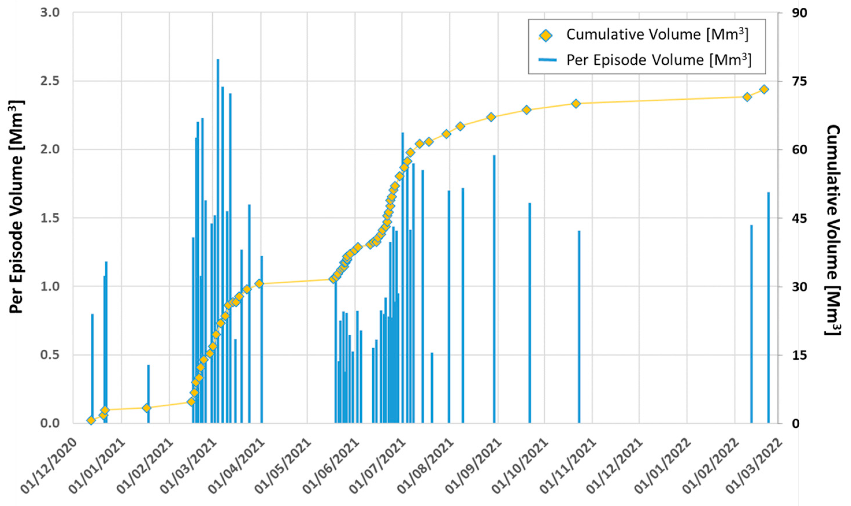
SEVIRI data were processed using the CL-HOTSAT system [34,35]. The system automatically downloads the SEVIRI images in near real time using the API service provided by EUMETSAT (the Data Access API Client) via a Python routine, locates the thermal anomalies (hotspots) present in each image and computes the radiant heat flux for each hotspot pixel. By summing up the radiant heat flux contribution of each hotspot pixel, a radiant heat flux value is computed per image. In this way, time series of radiant heat flux are obtained at the temporal resolution of 15 min.
The typical radiant heat flux curve associated with lava fountaining is characterized by three phases: (i) an initial period in which the heat flux slowly increases; (ii) a rapid increase in the radiant heat flux curve, during the climax phase of fountaining; (iii) a third phase characterized by waning heat flux, marked by a well-formed cooling curve, during which time the lava flows emplaced by the fountaining stagnate and cool. For the paroxysmal events occurring at Mt Etna between December 2020 and February 2022, we applied the technique presented in [37], which provides the volume emplaced during the lava fountains by modeling the third phase apparent in the SEVIRI-derived radiant heat flux curve, i.e., the cooling phase. This technique includes different steps: (i) assuming a stagnant, stable, cooling lava surface, for which the surface temperature can be estimated from the radiant heat flux using the Stefan-Boltzmann law [48,49,50]; (ii) fixing the starting time of the cooling, which is usually the first point when the curve starts to descend, as seen from comparison of thermal camera data [38]; (iii) converting the surface temperature in radiant heat flux, hence including the radiating area; (iv) setting a minimum and maximum thickness expected for these short-lived events (between 1 and 2 m), (v) estimating the emplaced volume based on the best combination of thicknesses and radiating areas. The best volume value is obtained by applying the Nelder-Mead algorithm by minimizing the mean squared error between the modeled and the measured heat flux curve [37]. We assume an uncertainty of ±30% as it derives from the radiant heat flux estimation [35]. This technique has been successfully applied several times at Etna volcano for modeling purposes (see, e.g., [31]), but in this case, we had the opportunity to validate the SEVIRI estimates through the volumetric information on the emitted mass obtained by using high spatial resolution stereo WorldView and tri-stereo Pleiades acquisitions.
In particular, we used four different acquisitions: a Pleiades triplet from 22 August 2020, a stereo pair WorldView-1 on 27 July 2021, and finally, thanks to the GNSL (Geohazard Supersites and Natural Laboratories) initiative at Mt Etna, we had the opportunity to acquire two Pleiades triplets on 26 February 2021 and 29 June 2022, respectively.
For the 22 August 2020 Pleiades triplet P1A, along-track incidence angles of the three images are −10.2°, −0.7°, and 10.6° for the forward (FW), near-nadir (NN), and backward (BW) viewing geometries, respectively, while the across-track angle varies between 2° and 7.3°. For the 26 February 2021 P1B, the along-track incidence angles are −10.2° (FW), 0.8° (NN) and 10.6° (BW) with the across-track angle varying between −5.1° and 0.4°, while for 29 June 2022 P1A, the along-track incidence angles are −10.1° (FW), −2.5° (NN) and 10.4° (BW), with the across-track angle varying between −4.6° and −3.3°. Each Pleiades image was provided as DIMAP GeoTIFF format, in 4 bands pansharpening, primary geometric processing level and basic radiometric processing level and 12 bits of radiometric accuracy. For each Pleiades full scene, an XML file containing the rational polynomial coefficients was provided, as well as nine different subscenes. Each full scene was reconstructed into a single GeoTIFF file from the DIMAP metadata and subscenes using the otbcli_Convert function available in the Orfeo ToolBox (https://www.orfeo-toolbox.org/, accessed on 3 November 2022).
Regarding the WorldView-1 stereo pair, it was provided as system-ready (1B) pair imagery product, for which the images are radiometrically and sensor corrected, but not projected to a plane using a map projection or datum. The sensor correction blends all pixels from all detectors into the synthetic array to form a single image, that usually is 15 km wide × 14 km long up to a maximum of a one-degree cell (approximately 110 km × 110 km) for WorldView-1. The two scenes were acquired on 27 July 2021 at mean in-track viewing angles of −28° and 5.6° and cross-track viewing angles of 12.5° and 14.5°, resulting in a mean GSD of 0.69 m and 0.52 m.
The Pléiades and WorldView imagery were processed using the free and open source MicMac photogrammetric library ([51]; http://micmac.ensg.eu, accessed on 10 October 2022) developed by the French IGN (Institut Géographique National), which consists of three main steps: (i) tie points recognition and matching between images; (ii) calibration and orientation, recognizing relationships between viewpoints and objects; (iii) correlation, producing dense matching for 3D scene reconstruction. For the Pléiades images, we modified the MicMac workflow without Ground Control Points (GCPs) developed by Dr. Luc Girod and freely available on GitHub (https://github.com/luc-girod/MicMacWorkflowsByLucGirod/blob/master/Sat-Pleiades-SPOT.sh, accessed on 3 November 2022). In this way, we obtained four 1 m DSMs [52], whose vertical accuracy was estimated by using 109 GPS Ground Control Points (GPCs) available outside the area covered by the volcanic deposits in the framework of the SVOP project (http://volcano.iterre.fr/svo_projects, accessed on 13 December 2022). Indeed, comparing the elevation of the four DSMs in the location of the GPS points, we found residuals ranging from −2.72 to 2.87 m, with an average value of 0.26 m and a standard deviation of 1.39 m, which represents the average vertical accuracy.
In order to minimize the errors due to misalignments, we performed pairwise co-registrations by applying the Nuth and Kääb algorithm [53], which finds the horizontal and vertical shifts between the DSMs using the slope-aspect method and removes them. After this, along/cross track corrections are eventually determined and applied.
By differencing successive DSMs, we obtained the topographic changes due to the emplacement of volcanic deposits from August 2020 to February 2021, from February to July 2021, and from July 2021 to June 2022. The total volume of products was calculated by integrating the thickness distribution over the area covered by the deposits, while the uncertainty was quantified as the product of the area and the standard deviation of terrain residuals outside of the deposits.

4. Results

The volumes obtained using SEVIRI data from December 2020 to February 2022 are shown in Figure 1 (see Supplementary Materials S1). Looking at the volume distribution of the single events, two main eruptive phases can be recognized: one from February to April 2021 and one from May to October 2021. Six small events, from December 2020 to January 2021, precede the first phase and the two 2022 events, on 10 and 21 February, follow the second phase.
The first phase, which lasts from 16 February to 1 April 2021, includes 17 paroxysmal events whose lava volumes have a bell-like distribution with the peak of 2.65 × 10⁶ m3 reached on 4 March 2021. The minimum lava volume was estimated on 15 March (0.6 × 10⁶ m3), while the median value for the whole phase is of 1.6 × 10⁶ m3 (first and third quartiles, 1.3 and 2.2 × 10⁶ m3). The cumulative volume for these 17 paroxysmal events is estimated to be approximately 27 ± 9 × 10⁶ m3, with an average output rate of 7.2 m3/s.
The second phase, which lasts from 19 May to 23 October 2021, can be further divided into two main periods, one from 19 May to 4 June 2021 and one from 12 June to 23 October 2021. Except for the 19 May event, which has erupted just over 1 million cubic meters of lava (1.02 × 10⁶ m3), all the paroxysmal events of May-June are characterized by low lava volumes, from 0.2 to 0.8 × 10⁶ m3, with an average value of 0.58 × 10⁶ m3 and an average output rate of 5.8 m3/s. Conversely, the events from 12 June to October 2021 show increasing volumes that reach almost constant values since 4 July (from 1.4 to 2 × 10⁶ m3, except for the 20 July event). The maximum and minimum volumes have been estimated for the 1 July (2.1 × 10⁶ m3) and 20 July events (0.5 × 10⁶ m3), with an average value of 1.26 × 10⁶ m3 (first quartile, median and third quartile, 0.8, 1.3 and 1.7 × 10⁶ m3, respectively) and an average output rate of 2.7 m3/s. The cumulative volume for these 40 paroxysmal events is estimated approximately to 39.5 ±11.8 × 10⁶ m3, of which 8.0 ± 2.4 × 10⁶ m3 emitted in correspondence of 14 events from 19 May to 4 June 2021 and 31.5 ± 9.4 × 10⁶ m3 during 26 events from 12 June to 23 October 2021 and an average output rate of 2.9 m3/s.
The three DSM differences reported in Figure 2 show the distribution of lava flows, as well as the SEC’s morphological changes due to the accumulation of volcanic deposits and the several collapses followed by the pyroclastic avalanches towards SE (16 and 24 February 2021, and 23 October 2021), and towards SSW (13 December 2020, 28 February 2021, and 10 February 2022) (see Supplementary Materials S2).
The difference between February 2021 and August 2020 (Period I) includes the volcanic products of 12 events, which cover a total area of 3.5 km2 (Figure 2a). The lava volume is estimated to be 18.1 ± 6.6 × 10⁶ m3. The maximum thickness measured in the lava flow field is about 30 m with an average and a median thickness of 5.5 m and 4.5 m, respectively. Most of the points in the lava flow field area show thickness below 10.8 m (i.e., 90th percentile), while the first and third quartile are 2.3 m and 7.3 m, respectively. The SEC during this period has experienced a volumetric increase of 16.4 ± 0.6 × 10⁶ m3 (with a maximum growth of about 40 m) and a small collapse of 0.09 ± 0.02 × 10⁶ m3 (maximum depth of 35 m). Average and median thicknesses are 17.1 m and 15.9 m, respectively. The 90th percentile is 27.7 m, while the first and third quartiles are 10.0 m and 21.8 m, respectively.
Between February and July 2021 (Period II), 46 paroxysmal events occurred at the SEC. This large number of eruptions caused it to increase by 26.4 ± 1.3 × 10⁶ m3, with a maximum height of 88 m (Figure 2b). The mean and the median thickness of the deposit emitted between February and July 2021 in the SEC area are 34.6 m and 30.9 m with the 1st quartile equal to 19.9 m, the 3rd quartile equal to 45.9 m and 90th percentile equal to 66.3 m. The volume of lava flows erupted in 5 months (36.9 ± 7.8 × 10⁶ m3) is double than the one emitted in the previous six months. The area covered by the deposits is 4.9 km2. The average and the median thickness measured in the lava flow field area are 8.3 m and 5.2 m, respectively, with a maximum value of about 40 m. The lava flow field is mostly below 17.7 m (i.e., 90th percentile), with the first and third quartile being 2.9 m and 10.0 m, respectively.
The difference between July 2021 and June 2022 (Period III) includes seven eruptive events that emitted 12.7 ± 3.8 × 10⁶ m3 of lava and increased the cone by 7.8 ± 0.9 × 10⁶ m3 (Figure 2c). The cone grew 15.4 m as average value and 14.6 m as median value. Most of the thickness is below 27.7 m (i.e.,90th percentile) with the 1st and the 3rd quartile equal to 8.0 m and 21.9 m, respectively. Lava flows emplaced in this period exhibit a mean and median thickness of 5.6 m and 4.4 m with most of the values below 10.9 m (i.e., 90th percentile) and the 1st and the 3rd quartile equal to 2.5 m and 7.0 m, respectively.
All estimates about lava volumes and SEC topographic changes obtained through DSM difference, as well as the CL-HOTSAT-derived volumes, are summarized in Figure 3.
In Period I, the DSM- and IR-derived lava flow volumes show good agreement, with only a small underestimation in the IR volumes, within the uncertainty range. For the Period II, however, the IR-derived volume is significantly (beyond the error estimates) larger than the DSM-derived volume, even though the DSM-derived volume still falls within the 30% uncertainty range of the IR volume. This difference in behavior is explained by the contribution of lava flows to cone growth, as already observed in a previous episode that occurred at Mt Etna [13]. Our distinction between cone and off-cone volume changes is based on the assumption that the off-cone volume change is dominated by IR-visible lava flows, while the volume change in the cone is dominated by ash and other proximal pyroclastic material that is largely undetected by IR sensors. However, this is only a first-order approximation, since off-cone volume changes also receive contributions from pyroclastic material, and lava flows also contribute to cone growth.
When comparing the off-cone and cone volume growth, a much higher contribution to the cone growth than to the off-cone volume change is evident in Period II: where for Periods I and III, the average off-cone volume change is ~1.7 ± 0.4 × 10⁶ m3 per event, in Period II, we see a much lower average volume change of only ~0.8 ± 0.17 × 10⁶ m3 per event. This is in contrast to the IR-derived average volumes, which fall within ~1.5 ± 0.7 × 10⁶ m3 in all three periods, and can be explained with a greater contribution of the pyroclastics erupted during the lava fountains [14]. It is worth to note that we are not taking into account possible variations in the vesicularity that can be extremely variable (e.g., 20–50%) if we consider the welded spatter comprising the cone or the lava flows (e.g., [54]) and that this contributes to the total uncertainty.
The SEC cone, being the youngest among the summit craters at Mt Etna, has been very active in recent periods, growing to ~ 36 × 106 m3 (bulk volume) between 1996 and 2001 and reaching a total volume of ~72 × 106 m3 by 2001 [54]. Moreover, very rapid growths of a cone have been already experienced at Mt Etna, for example during the 2001 flank eruption when the “Laghetto” cone formed at 2500 m a.s.l. This cone formed in just one week and eventually reached the size of 300 m as the base diameter and 62 m high, with a summit crater 50 m wide, for a total volume of ~ 2 × 10⁶ m3 [55].
Analyzing the duration and lava volume of all the lava fountains at Mt Etna from 1998 to 2018, a remarkable change in the eruptive activity of Etna has been found starting from the growth of the SEC in 2011 [24,56]. In addition to the increase in the number of events, this change concerns a shift in the location of volcanism, as well as a considerable variation in the eruptive style from shorter to longer duration and from smaller to larger volumes. The sequence of events occurred in 2020–2022 confirms this trend with a further increase in the average output rate (see also [52,57]).

5. Conclusions

Integrating thermal infrared and optical satellite imagery at different spatial and temporal resolutions allows cross-validation of the results and the extraction of new information that could not be provided using only one of the methods. Applying a combined methodology to the analysis of the fountaining activity of Mt Etna between December 2020 and February 2022 has allowed us not only to provide tighter error bounds on the volume estimates, but also to extract some information on the relative distribution of pyroclastic and effusive material, as well as to estimate the respective contributions to the growth of the South-East Crater. In addition, our lava and cone volume estimations of 67.7 ± 8.4 × 10⁶ m3 and 40.6 ± 1.4 × 10⁶ m3, respectively allow a total estimation of the erupted volume (lava plus pyroclastics) between 22 August 2020 and 29 June 2022 of 108.3 ± 9.8 × 10⁶ m3, with an average output rate of about 2.88 m3/s. This is much higher than the average 0.8–0.9 m3/s that characterizes the steady state of the volcano [26,27,39], but is sufficient to bring the volcano in a state of relatively quiet, having erupted all the surplus of magma accumulated during the previous phase of inactivity [8,27].

Supplementary Materials

The following supporting information can be downloaded at: https://www.mdpi.com/article/10.3390/rs15040916/s1, the dataset includes: (1) the volumes obtained from the modeling of the radiant heat flux curve observed in SEVIRI data for the paroxysmal events occurred at Mt Etna during the December 2020–February 2022 period and the volumes obtained from DSM difference in three time windows (from 22 August 2020 to 26 February 2021; from 26 February to 27 July 2021; and from 27 July 2021 to 29 June 2022) (Satellite_derivedVolumes2020_22.xlsx); and (2) raster maps in .bsq format of volcanic deposits emplaced at Mt Etna obtained from DSMs difference during three periods: from 22 August 2020 to 26 February 2021 (1); from 26 February to 27 July 2021 (2) and from 27 July 2021 to 29 June 2022 (3) (DepositsEtna2020_2021.zip).

Author Contributions

Conceptualization, G.G.; methodology, G.G.; software, G.G. and G.B.; validation, A.C., F.Z. and S.C.; formal analysis, A.C.; data curation, G.G. and A.C.; writing—original draft preparation, G.G., F.Z. and A.C.; writing—review and editing, G.G., A.C. and S.C.; visualization, A.C. and G.B.; funding acquisition, G.G. and A.C. All authors have read and agreed to the published version of the manuscript.

Funding

This work was supported by the INGV project Pianeta Dinamico (CUP D53J19000170001) funded by MIUR (“Fondo finalizzato al rilancio degli investimenti delle amministrazioni centrali dello Stato e allo sviluppo del Paese,” legge 145/2018), Tema 8—PANACEA, Scientific Responsibility: A.C.). The research was also funded by “TUNE—Effusion rate estimates at Etna and Stromboli: constraints imposed by a variety of satellite remote sensing data” (Bando di Ricerca Libera 2019 of INGV; Scientific Responsibility: G.G.). This research was also supported by the Project FIRST—ForecastIng eRuptive activity at Stromboli volcano: timing, eruptive style, size, intensity, and duration, INGV-Progetto Strategico Dipartimento Vulcani 2019 (Delibera n. 144/2020; Scientific Responsibility: S.C.).

Data Availability Statement

SEVIRI data are available at Eumetsat data store (https://data.eumetsat.int/, accessed on 10 October 2022) and were downloaded using the Application Program Interfaces. Pleiades imagery was provided by the CNES and is available through the Mt Etna supersite initiative see http://geo-gsnl.org/supersites/permanent-supersites/mt-etna-volcano-supersite-new/ (accessed on 10 October 2022). MicMac photogrammetry software is freely available at https://micmac.ensg.eu/index.php/Install (accessed on 10 October 2022).

Acknowledgments

We thank the GNSL Mt Etna volcano Supersite initiative.

Conflicts of Interest

The authors declare no conflict of interest.

References

  1. Viccaro, M.; Zuccarello, F.; Cannata, A.; Palano, M.; Gresta, S. How a complex basaltic volcanic system works: Constraints from integrating seismic, geodetic, and petrological data at Mount Etna volcano during the July-August 2014 eruption. J. Geophys. Res. Solid Earth 2016, 121, 5659–5678. [Google Scholar] [CrossRef]
  2. De Beni, E.; Cantarero, M.; Neri, M.; Messina, A. Lava flows of Mt Etna, Italy: The 2019 eruption within the context of the last two decades (1999–2019). J. Maps 2020, 17, 65–76. [Google Scholar] [CrossRef]
  3. Andronico, D.; Cannata, A.; Di Grazia, G.; Ferrari, F. The 1986–2021 paroxysmal episodes at the summit craters of Mt. Etna: Insights into volcano dynamics and hazard. Earth-Sci. Rev. 2021, 220, 103686. [Google Scholar] [CrossRef]
  4. Giuffrida, M.; Scandura, M.; Costa, G.; Zuccarello, F.; Sciotto, M.; Cannata, A.; Viccaro, M. Tracking the summit activity of Mt. Etna volcano between July 2019 and January 2020 by integrating petrological and geophysical data. J. Volcanol. Geotherm. Res. 2021, 418, 107350. [Google Scholar] [CrossRef]
  5. Behncke, B.; Branca, S.; Corsaro, R.A.; De Beni, E.; Miraglia, L.; Proietti, C. The 2011–2012 summit activity of Mount Etna: Birth, growth and products of the new SE crater. J. Volcanol. Geotherm. Res. 2014, 270, 10–21. [Google Scholar] [CrossRef]
  6. Giuffrida, M.; Viccaro, M. Three years (2011–2013) of eruptive activity at Mt. Etna: Working modes and timescales of the modern volcano plumbing system from microanalytical studies of crystals. Earth Sci. Rev. 2017, 171, 289–322. [Google Scholar] [CrossRef]
  7. Calvari, S.; Cannavo’, F.; Bonaccorso, A.; Spampinato, L.; Pellegrino, A.G. Paroxysmal Explosions, Lava Fountains and Ash Plumes at Etna Volcano: Eruptive Processes and Hazard Implications. Front. Earth Sci. 2018, 6, 107. [Google Scholar] [CrossRef]
  8. Bonaccorso, A.; Calvari, S. A new approach to investigate an eruptive paroxysmal sequence using camera and strainmeter networks: Lessons from the 3–5 December 2015 activity at Etna volcano. Earth Planet. Sci. Lett. 2017, 475, 231–241. [Google Scholar] [CrossRef]
  9. Corsaro, R.; Andronico, D.; Behncke, B.; Branca, S.; Caltabiano, T.; Ciancitto, F.; Cristaldi, A.; De Beni, E.; La Spina, A.; Lodato, L.; et al. Monitoring the December 2015 summit eruptions of Mt. Etna (Italy): Implications on eruptive dynamics. J. Volcanol. Geotherm. Res. 2017, 341, 53–69. [Google Scholar] [CrossRef]
  10. Cannata, A.; Di Grazia, G.; Giuffrida, M.; Gresta, S.; Palano, M.; Sciotto, M.; Viccaro, M.; Zuccarello, F. Space-Time Evolution of Magma Storage and Transfer at Mt. Etna Volcano (Italy): The 2015–2016 Reawakening of Voragine Crater. Geochem. Geophys. Geosyst. 2018, 19, 471–495. [Google Scholar] [CrossRef]
  11. Borzi, A.M.; Giuffrida, M.; Zuccarello, F.; Palano, M.; Viccaro, M. The Christmas 2018 Eruption at Mount Etna: Enlightening How the Volcano Factory Works Through a Multiparametric Inspection. Geochem. Geophys. Geosyst. 2020, 21, 9226. [Google Scholar] [CrossRef]
  12. Calvari, S.; Bilotta, G.; Bonaccorso, A.; Caltabiano, T.; Cappello, A.; Corradino, C.; Del Negro, C.; Ganci, G.; Neri, M.; Pecora, E.; et al. The VEI 2 Christmas 2018 Etna Eruption: A Small But Intense Eruptive Event or the Starting Phase of a Larger One? Remote Sens. 2020, 12, 905. [Google Scholar] [CrossRef]
  13. Calvari, S.; Bonaccorso, A.; Ganci, G. Anatomy of a Paroxysmal Lava Fountain at Etna Volcano: The Case of the 12 March 2021, Episode. Remote Sens. 2021, 13, 3052. [Google Scholar] [CrossRef]
  14. Calvari, S.; Nunnari, G. Comparison between Automated and Manual Detection of Lava Fountains from Fixed Monitoring Thermal Cameras at Etna Volcano, Italy. Remote Sens. 2022, 14, 2392. [Google Scholar] [CrossRef]
  15. Corsaro, R.A.; Miraglia, L. Near Real-Time Petrologic Monitoring on Volcanic Glass to Infer Magmatic Processes During the February–April 2021 Paroxysms of the South-East Crater, Etna. Front. Earth Sci. 2022, 10, 828026. [Google Scholar] [CrossRef]
  16. Calvari, S.; Biale, E.; Bonaccorso, A.; Cannata, A.; Carleo, L.; Currenti, G.; Di Grazia, G.; Ganci, G.; Iozzia, A.; Pecora, E.; et al. Explosive Paroxysmal Events at Etna Volcano of Different Magnitude and Intensity Explored through a Multidisciplinary Monitoring System. Remote Sens. 2022, 14, 4006. [Google Scholar] [CrossRef]
  17. Calvari, S.; Neri, M.; Pinkerton, H. Effusion rate estimations during the 1999 summit eruption on Mount Etna, and growth of two distinct lava flow fields. J. Volcanol. Geotherm. Res. 2003, 119, 107–123. [Google Scholar] [CrossRef]
  18. Burton, M.R.; Neri, M.; Andronico, D.; Branca, S.; Caltabiano, T.; Calvari, S.; Corsaro, R.A.; Del Carlo, P.; Lanzafame, G.; Lodato, L.; et al. Etna 2004–2005: An archetype for geodynamically-controlled effusive eruptions. Geophys. Res. Lett. 2005, 32, 22527. [Google Scholar] [CrossRef]
  19. Behncke, B.S.; Calvari, S.; Giammanco, M.; Pinkerton, N.H. Pyroclastic density currents resulting from the interac-tion of basaltic magma with hydrothermally altered rock: An example from the 2006 summit eruptions of Mount Etna, Italy. Bull. Volcanol. 2008, 70, 1249–1268. [Google Scholar] [CrossRef]
  20. Andronico, D.; Di Roberto, A.; De Beni, E.; Behncke, B.; Bertagnini, A.; Del Carlo, P.; Pompilio, M. Pyroclastic den-sity currents at Etna volcano, Italy: The 11 February 2014 case study. J. Volcanol. Geotherm. Res. 2018, 357, 92–105. [Google Scholar] [CrossRef]
  21. Marzano, F.S. Remote Sensing of Volcanic Ash Cloud During Explosive Eruptions Using Ground-Based Weather RADAR Data Processing [In the Spotlight]. IEEE Signal Process. Mag. 2011, 28, 128–126. [Google Scholar] [CrossRef]
  22. Andronico, D.; Del Carlo, P. PM10 measurements in urban settlements after lava fountain episodes at Mt. Etna, Italy: Pilot test to assess volcanic ash hazard to human health. Nat. Hazards Earth Syst. Sci. 2016, 16, 29–40. [Google Scholar] [CrossRef]
  23. Horwell, C.J.; Sargent, P.; Andronico, D.; Castro, M.D.L.; Tomatis, M.; Hillman, S.E.; Michnowicz, S.A.K.; Fubini, B. The iron-catalysed surface reactivity and health-pertinent physical characteristics of explosive volcanic ash from Mt. Etna, Italy. J. Appl. Volcanol. 2017, 6, 12. [Google Scholar] [CrossRef]
  24. Cappello, A.; Ganci, G.; Bilotta, G.; Corradino, C.; Hérault, A.; Del Negro, C. Changing Eruptive Styles at the South-East Crater of Mount Etna: Implications for Assessing Lava Flow Hazards. Front. Earth Sci. 2019, 7, 213. [Google Scholar] [CrossRef]
  25. Ganci, G.; Cappello, A.; Bilotta, G.; Del Negro, C. How the variety of satellite remote sensing data over volcanoes can assist hazard monitoring efforts: The 2011 eruption of Nabro volcano. Remote Sens. Environ. 2020, 236, 111426. [Google Scholar] [CrossRef]
  26. Wadge, G.; Guest, J.E. Steady-state magma discharge at Etna 1971–1981. Nature 1981, 294, 548–550. [Google Scholar] [CrossRef]
  27. Bonaccorso, A.; Calvari, S. Major effusive eruptions and recent lava fountains: Balance between expected and erupted magma volumes at Etna volcano. Geophys. Res. Lett. 2013, 40, 6069–6073. [Google Scholar] [CrossRef]
  28. Müller, D.; Walter, T.R.; Schöpa, A.; Witt, T.; Steinke, B.; Gudmundsson, M.T.; Dürig, T. High-resolution digital eleva-tion modeling from TLS and UAV campaign reveals structural complexity at the 2014/2015 Holuhraun eruption site, Iceland. Front. Earth Sci. 2017, 5, 59. [Google Scholar] [CrossRef]
  29. Darmawan, H.; Walter, T.R.; Brotopuspito, K.S.; Subandriyo; Nandaka, I.G.M.A. Morphological and structural changes at the Merapi lava dome monitored in 2012–15 using unmanned aerial vehicles (UAVs). J. Volcanol. Geotherm. Res. 2018, 349, 256–267. [Google Scholar] [CrossRef]
  30. Cappello, A.; Ganci, G.; Calvari, S.; Pérez, N.M.; Hernández, P.A.; Silva, S.V.; Cabral, J.; Del Negro, C. Lava flow hazard modeling during the 2014–2015 Fogo eruption, Cape Verde. J. Geophys. Res. Solid Earth 2016, 121, 2290–2303. [Google Scholar] [CrossRef]
  31. Cappello, A.; Ganci, G.; Bilotta, G.; Herault, A.; Zago, V.; Del Negro, C. Satellite-driven modeling approach for monitoring lava flow hazards during the 2017 Etna eruption. Ann. Geophys. 2018, 61, 13. [Google Scholar] [CrossRef]
  32. Ganci, G.; Vicari, A.; Cappello, A.; Del Negro, C. An emergent strategy for volcano hazard assessment: From thermal satellite monitoring to lava flow modeling. Remote Sens. Environ. 2012, 119, 197–207. [Google Scholar] [CrossRef]
  33. Coppola, D.; Laiolo, M.; Lara, L.E.; Cigolini, C.; Orozco, G. Enhanced volcanic hot-spot detection using MODIS IR data: Results from the MIROVA system. In Detecting, Modelling, and Responding to Effusive Eruptions; Harris, A., De Groeve, T., Garel, F., Carn, S.A., Eds.; Geological Society Special Publications: London, UK, 2016; Volume 426. [Google Scholar]
  34. Ganci, G.; Vicari, A.; Fortuna, L.; Del Negro, C. The HOTSAT volcano monitoring system based on combined use of SEVIRI and MODIS multispectral data. Ann. Geophys. 2011, 54, 5338. [Google Scholar] [CrossRef]
  35. Ganci, G.; Bilotta, G.; Cappello, A.; Herault, A.; Del Negro, C. HOTSAT: A multiplatform system for the thermal monitoring of volcanic activity using satellite data. Geol. Soc. Lond. Spéc. Publ. 2015, 426, 207–221. [Google Scholar] [CrossRef]
  36. Del Negro, C.; Cappello, A.; Ganci, G. Quantifying lava flow hazards in response to effusive eruption. GSA Bull. Geol. Soc. Am. 2015, 128, 752–763. [Google Scholar] [CrossRef]
  37. Ganci, G.; Harris, A.J.L.; Del Negro, C.; Guehenneux, Y.; Cappello, A.; Labazuy, P.; Calvari, S.; Gouhier, M. A year of lava fountaining at Etna: Volumes from SEVIRI. Geophys. Res. Lett. 2012, 39, 1026. [Google Scholar] [CrossRef]
  38. Ganci, G.; James, M.R.; Calvari, S.; Del Negro, C. Separating the thermal fingerprints of lava flows and simultaneous lava fountaining using ground-based thermal camera and SEVIRI measurements. Geophys. Res. Lett. 2013, 40, 5058–5063. [Google Scholar] [CrossRef]
  39. Ganci, G.; Cappello, A.; Bilotta, G.; Hérault, A.; Zago, V.; Del Negro, C. Mapping Volcanic Deposits of the 2011–2015 Etna Eruptive Events Using Satellite Remote Sensing. Front. Earth Sci. 2018, 6, 83. [Google Scholar] [CrossRef]
  40. Mudd, S.M. Topographic data from satellites. Dev. Earth Surf. Process. 2020, 23, 91–128. [Google Scholar] [CrossRef]
  41. Ganci, G.; Cappello, A.; Zago, V.; Bilotta, G.; Herault, A.; Del Negro, C. 3D Lava flow mapping of the 17–25 May 2016 Etna eruption using tri-stereo optical satellite data. Ann. Geophys. 2018, 61, 15. [Google Scholar] [CrossRef]
  42. Favalli, M.; Fornaciai, A.; Nannipieri, L.; Harris, A.; Calvari, S.; Lormand, C. UAV-based remote sensing surveys of lava flow fields: A case study from Etna’s 1974 channel-fed lava flows. Bull. Volcanol. 2018, 80, 29. [Google Scholar] [CrossRef]
  43. De Beni, E.; Cantarero, M.; Messina, A. UAVs for volcano monitoring: A new approach applied on an active lava flow on Mt. Etna (Italy), during the 27 February–02 March 2017 eruption. J. Volc. Geoth. Res. 2019, 369, 250–262. [Google Scholar] [CrossRef]
  44. Hirn, B.C.; Di Bartola, G.; Laneve, C.; Adau, E.; Ferrucci, F. SEVIRI onboard Meteosat Second Generation, and the quantitative monitoring of effusive volcanoes in Europe and Africa. In Proceedings of the IEEE International Geoscience and Remote Sensing Symposium (IGARSS 2008), New York, NY, USA, 6–11 July 2008; pp. 374–377. [Google Scholar]
  45. Bonaccorso, A.; Caltabiano, T.; Currenti, G.; Del Negro, C.; Gambino, S.; Ganci, G.; Giammanco, S.; Greco, F.; Pistorio, A.; Salerno, G.; et al. Dynamics of a lava fountain revealed by geophysical, geochemical and thermal satellite measurements: The case of the 10 April 2011 Mt Etna eruption. Geophys. Res. Lett. 2011, 38, 49637. [Google Scholar] [CrossRef]
  46. De Lussy, F.D.; Greslou, C.; Dechoz, V.; Amberg, J.M.; Delvit, L.; Lebegue, G.; Blanchet, S. Fourest Pleiades HR in flight geometrical calibration: Location and mapping of the focal plane. Int. Arch. Photogramm. Remote Sens. Spat. Inform. Sci. 2012, 39, 519–523. [Google Scholar] [CrossRef]
  47. Bernard, M.D.; Decluseau, L.; Nonin, G.P. 3D capabilities of Pleaides satellite. Int. Arch. Photogramm. Remote Sens. Spat. Inform. Sci. 2012, 39, 553–557. [Google Scholar] [CrossRef]
  48. Hon, K.J.; Denlinger, K.R.; Mackay, K. Emplacement and inflation of pahoehoe sheet flows: Observations and measurements of active lava flows on Kilauea Volcano, Hawaii. Geol. Soc. Am. Bull. 1994, 106, 351–370. [Google Scholar] [CrossRef]
  49. Harris, A.J.L.; Dehn, J.; James, M.R.; Hamilton, C.; Herd, R.; Lodato, L.; Steffke, A. Pāhoehoe flow cooling, discharge, and coverage rates from thermal image chronometry. Geophys. Res. Lett. 2007, 34, 30791, Correction in Geophys. Res. Lett. 2008, 35, 36401. [Google Scholar] [CrossRef]
  50. Rogic, N.; Cappello, A.; Ganci, G.; Maturilli, A.; Rymer, H.; Blake, S.; Ferrucci, F. Spaceborne EO and a Combination of Inverse and Forward Modelling for Monitoring Lava Flow Advance. Remote Sens. 2019, 11, 3032. [Google Scholar] [CrossRef]
  51. Rupnik, E.; Daakir, M.; Deseilligny, M.P. MicMac—A free, open-source solution for photogrammetry. Open Geospat. Data Softw. Stand. 2017, 2, 1–9. [Google Scholar] [CrossRef]
  52. Ganci, G.; Cappello, A.; Neri, M. Data Fusion for Satellite-Derived Earth Surface: The 2021 Topographic Map of Etna Volcano. Remote Sens. 2022, 15, 198. [Google Scholar] [CrossRef]
  53. Nuth, C.; Kääb, A. Co-registration and bias corrections of satellite elevation data sets for quantifying glacier thickness change. Cryosphere 2011, 5, 271–290. [Google Scholar] [CrossRef]
  54. Behncke, B.; Neri, M.; Pecora, E.; Zanon, V. The exceptional activity and growth of the Southeast Crater, Mount Etna (Italy), between 1996 and 2001. Bull. Volcanol. 2006, 69, 149–173. [Google Scholar] [CrossRef]
  55. Calvari, S.; Pinkerton, H. Birth, growth and morphologic evolution of the ‘Laghetto’ cinder cone during the 2001 Etna eruption. J. Volcanol. Geotherm. Res. 2004, 132, 225–239. [Google Scholar] [CrossRef]
  56. Zuccarello, F.; Bilotta, G.; Cappello, A.; Ganci, G. Effusion Rates on Mt. Etna and Their Influence on Lava Flow Hazard Assessment. Remote Sens. 2022, 14, 1366. [Google Scholar] [CrossRef]
  57. Calvari, S.; Nunnari, G. Etna Output Rate during the Last Decade (2011–2022): Insights for Hazard Assessment. Remote Sens. 2022, 14, 6183. [Google Scholar] [CrossRef]
Figure 1. Lava volumes obtained using SEVIRI data from December 2020 to February 2022. Blue bars represent the volume emitted during each event, while the yellow curve shows the cumulative volume for the entire period (see Supplementary Materials S1).
Remotesensing 15 00916 g001
Figure 2. Topographic changes due to the volcanic deposits emplaced from 22 August 2020 to 26 February 2021 (a), from 26 February to 27 July 2021 (b) and from 27 July 2021 to 29 June 2022 (c). The colors indicate the flow thickness in meters. The dotted black circle defines the area of the SEC cone (see Supplementary Materials S2).
Remotesensing 15 00916 g002
Figure 3. On top, volumes of the volcanic deposits from SEVIRI data (indigo bars) and DSM difference (orange bars) emplaced from 22 August 2020 to 26 February 2021, from 26 February to 27 July 2021 and from 27 July 2021 to 29 June 2022. The vertical black lines indicate the associated uncertainties. The table below summarizes the number of events, the lava volume and SEC changes from DSM difference, and the SEVIRI-derived volumes for the same three periods (black) and in total (red) (see Supplementary Materials S1).
Remotesensing 15 00916 g003
Disclaimer/Publisher’s Note: The statements, opinions and data contained in all publications are solely those of the individual author(s) and contributor(s) and not of MDPI and/or the editor(s). MDPI and/or the editor(s) disclaim responsibility for any injury to people or property resulting from any ideas, methods, instructions or products referred to in the content.

