1. Introduction
Land cover change (LCC) information plays an essential role in global climate change, land atmosphere water and carbon cycle, energy, and material balance [
1]. Under the influence of human activities and natural disasters, land cover shows the characteristic of a strong dynamic, and the land cover type, coverage density, and area shape easily change over time [
2]. LCC has been considered to be one of the seven challenges in environmental science. LCC monitoring has a great implication for revealing the dynamics and predicting the future of global land change, climate change, earth system, and ecosystem sustainability [
1,
3,
4].
With the rapid development of remote-sensed sensors and information processing technologies, LCC monitoring could be conducted with a different spatial resolution of remote sensing imagery [
5,
6]. Various LCC products are being merged from a local to a global scale [
7]. During the traditional LCC detection manner, the imagery datasets need to be downloaded locally, and geoprocessing tools are selected to extract LCC information with the help of desktop-based software. As the datasets are very large and the geoprocessing process needs much professional knowledge, the traditional manner is usually time-consuming and laborious. With more and more easy access to rich remote-sensed datasets [
8], advanced tools and methods need to be provided for end-users to conveniently acquire LCC information [
9].
In recent years, Geospatial Web Services (GWS) have provided a novel manner to enable users to leverage distributed geospatial data, products, and computing resources over the network for geospatial data sharing, reusing, and integration. To facilitate the interoperability of GWS, Open Geospatial Consortium (OGC) published several open geospatial standards and specifications based on Service Oriented Architecture (SOA), such as Catalog Service for the Web (CSW), Web Map Service (WMS), Web Feature Service (WFS), Web Coverage Service (WCS), Web Processing Service (WPS), and Web Coverage Processing Service (WCPS). By using these OGC standards, a number of land cover datasets have been developed for online open access, such as GlobeLand30, GLS30, and FROM-GLC. In addition, many land cover change detection algorithms and models are encapsulated and published as web processing services, which facilitate end-users to acquire LCC information for online land cover applications. One recent example is the on-demand and web-based land cover change detection service chain derived by automatic service composition [
10].
Currently, a growing number of users with various knowledge backgrounds need to use the higher spatial resolution and more temporally frequent LCC data for their own applications [
11,
12,
13]. Although a number of LCC services and platforms have been developed, most of them mainly focus on ‘static’ land cover information about specific time and area, which seldom takes into account the spatiotemporal characteristics and dynamic generation of LCC information [
14]. The LCC information cannot be dynamically obtained to indicate which places and land cover types have changed. Therefore, a thorough and comprehensive web service-based solution is still lacking for LCC monitoring from LCC data access to processing and analysis.
To address the above challenge, a dynamic service computing model (DSCM) is proposed for facilitating end-users to obtain personalized and efficient LCC information in a fast and convenient way. An on-demand land cover change result could be returned to end-users by adaptive adjustment of the DSCM based on users’ requirements. The DSCM consists of three patterns to ensure end-users browse and download land cover change information with less professional knowledge. Through the adaptive adjustment of the DSCM according to the user’s needs, near real-time, multi-scale LCC results can be returned to the end user by three service strategies. Simultaneously, it will be published as a resource service to realize the sharing of data resources so as to ensure that end users browse and download LCC information with less expertise.
2. Dynamic Service-Oriented Computing Model
2.1. Motivation of DSCM
Change detection is the process of quantitatively analyzing and identifying the characteristics and process of land cover changes from remote sensing data in various periods [
15]. The objective of land cover change detection is to detect change areas and change types [
16,
17]. From the viewpoint of user requirement, there are the following three levels in change detection [
18]. (1) LCC area detection, i.e., where LCC happens? (2) Single type of LCC detection, i.e., where does LCC with a specific cover type (e.g., cropland or grass) happen? Has the changing area been increased or decreased? (3) Various types of LCC detection, i.e., where cover type A (e.g., cropland) is changed to cover type B (e.g., buildings)?
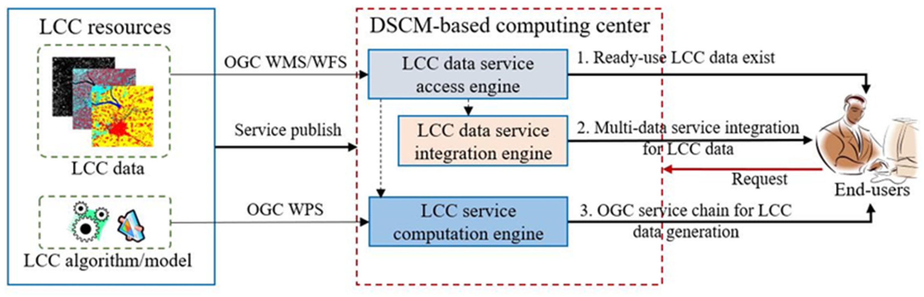
In order to address the above requirements, a dynamic service-oriented computing model was developed with three different strategies, as shown in
Figure 1. WMS-LCC-based LCC data access is designed for the situation of LCC data existing for ready-use. Spatial relation-based LCC dynamic extraction was proposed for LCC data that do not exist, but the land cover data from two different times have been ready, which could be used for LCC data generation by using spatial relation-based geoprocessing operation. On-demand LCC service composition was developed for the situation of there being LCC data or land cover data for ready-use, but multi-temporal remote-sensed imagery can be used for land cover change detection.
2.2. LCC Data Service Access and Integration
2.2.1. WMS-LCC for LCC Data Access
The existing OGC data service standards (e.g., WMS, WFS, and WCS) are generally focused on the access and query for snapshot information from a single time. For example, by using the ‘GetMap’ operation of OGC WMS 1.3, a specific snapshot map could be returned to end-users according to users’ inputs (e.g., layer name, bounding box, and projection). LCC data reflect the change information of given time intervals and specific land cover types, and the current OGC standards may not be directly satisfied for LCC data. The current OGC data service standards may not directly satisfy LCC data access, because LCC data provide LCC information for a certain time period and land cover type. Thus, we proposed a specific LCC data interface by extending OGC WMS, which is called WMS-LCC. Aiming at access to LCC data, ‘GetLCCMap’ operation is defined for the requirement of display in the client. The parameters of ‘GetLCCMap’ operation are described in
Table 1.
In order to meet the demands of increasing information transmission and processing, we generally specify the matching data body according to different application categories. Two kinds of change information data bodies are defined, taking into account the LCC data application and requirements. The first type uses high-level data compression supported by JPG and PNG to better fit the actual needs of the client and increase network transmission efficiency. The second type uses TIF, GeoTIFF, and other data formats of metadata attachment capabilities to process and analyze LCC data with supporting the user’s computational demands for LCC. Basic information, functional interface information, and content information make up the metadata of the LCC data service. The basic information includes description and overview information such as service name, title, online resource address, abstract, keywords, etc. The parameters, parameter format, request–response, and other components that are primarily exposed to the outside world make up the service interface. The content information should include a data body description, references, land cover resolution, classification scheme, and other contents.
2.2.2. Spatial Relation-Based LCC Data Integration
Land cover, encompassing categories such as natural or artificial farmland, industrial land, water bodies, and vegetation, is frequently indicated by the type of cover present on the land, and this information is crucial for identifying changes [
19]. Land cover data can be found through data service integration, which has seen the availability of land cover data with a variety of spatial resolutions, thematic categories, and geographic scales in recent years [
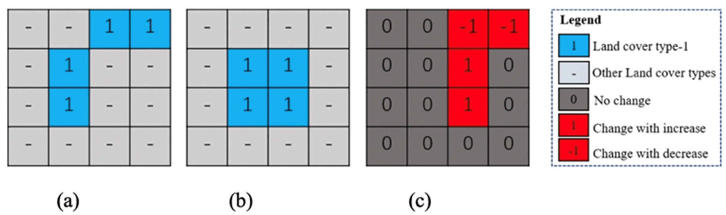
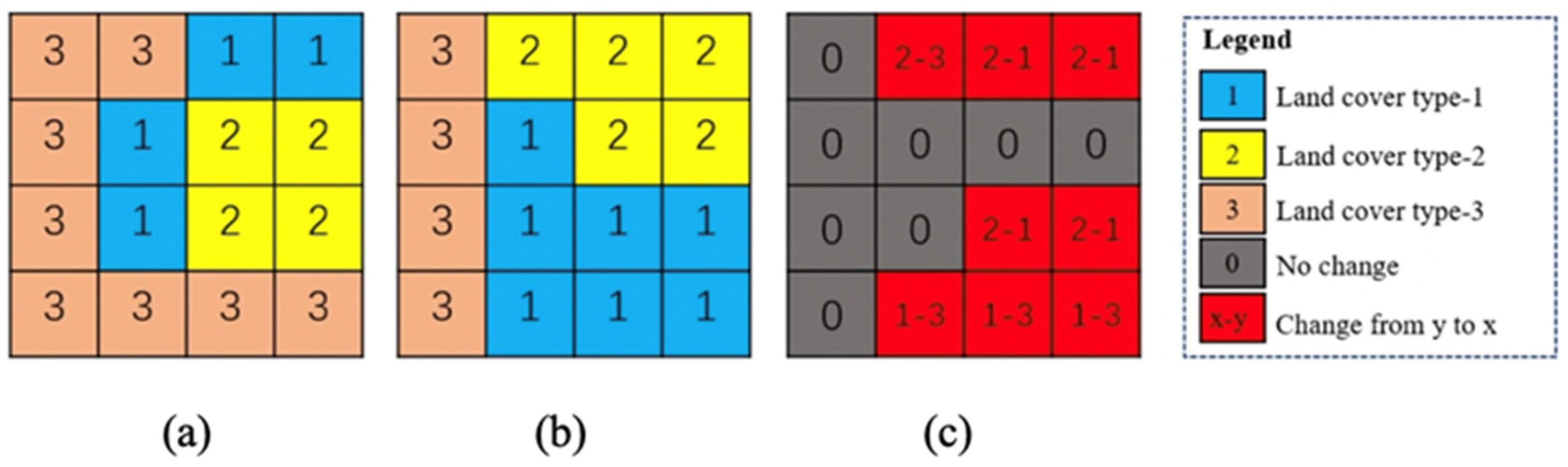
20]. To extract land cover changes, the use of land cover data from two periods is usually overlapping, so in the case of multi-time images (for example, views of the same area in different years), the difference operation is performed using two satellite images to obtain different types of changes [
21]. The land cover maps created by T1 and T2 can be used to create single-type or multi-type LCC data using pixel-by-pixel difference operations, as shown in
Figure 2 and
Figure 3.
2.3. LCC Processing Service Composition
Land cover change detection is a geoprocessing task involving multiple computing steps such as data preprocessing, change information generation, change information classification, and post-processing. To implement a comprehensive change detection request, various interoperable web services for processing activities should be coupled.
2.3.1. Model Encapsulation
Inside a network environment, models act as the bearers of shared services. Models can be released in the network space as reusable web services based on OGC standards and geographic model deployment strategies [
22], enabling end users to combine them into intricate workflows.
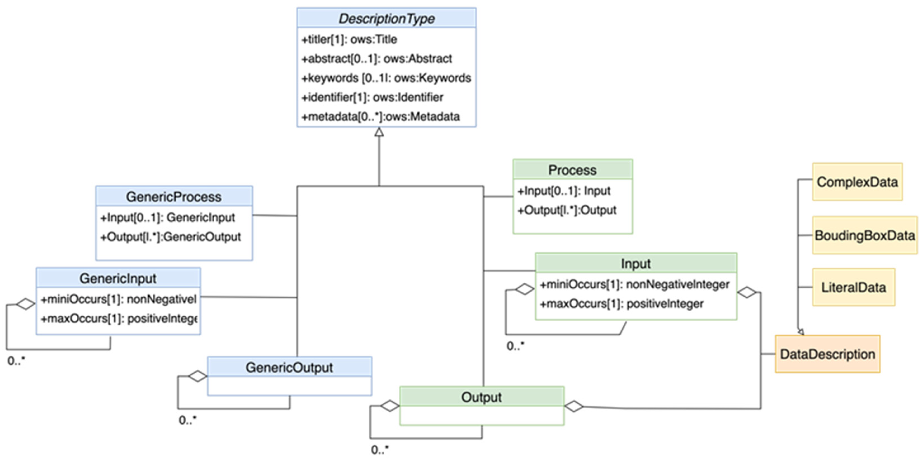
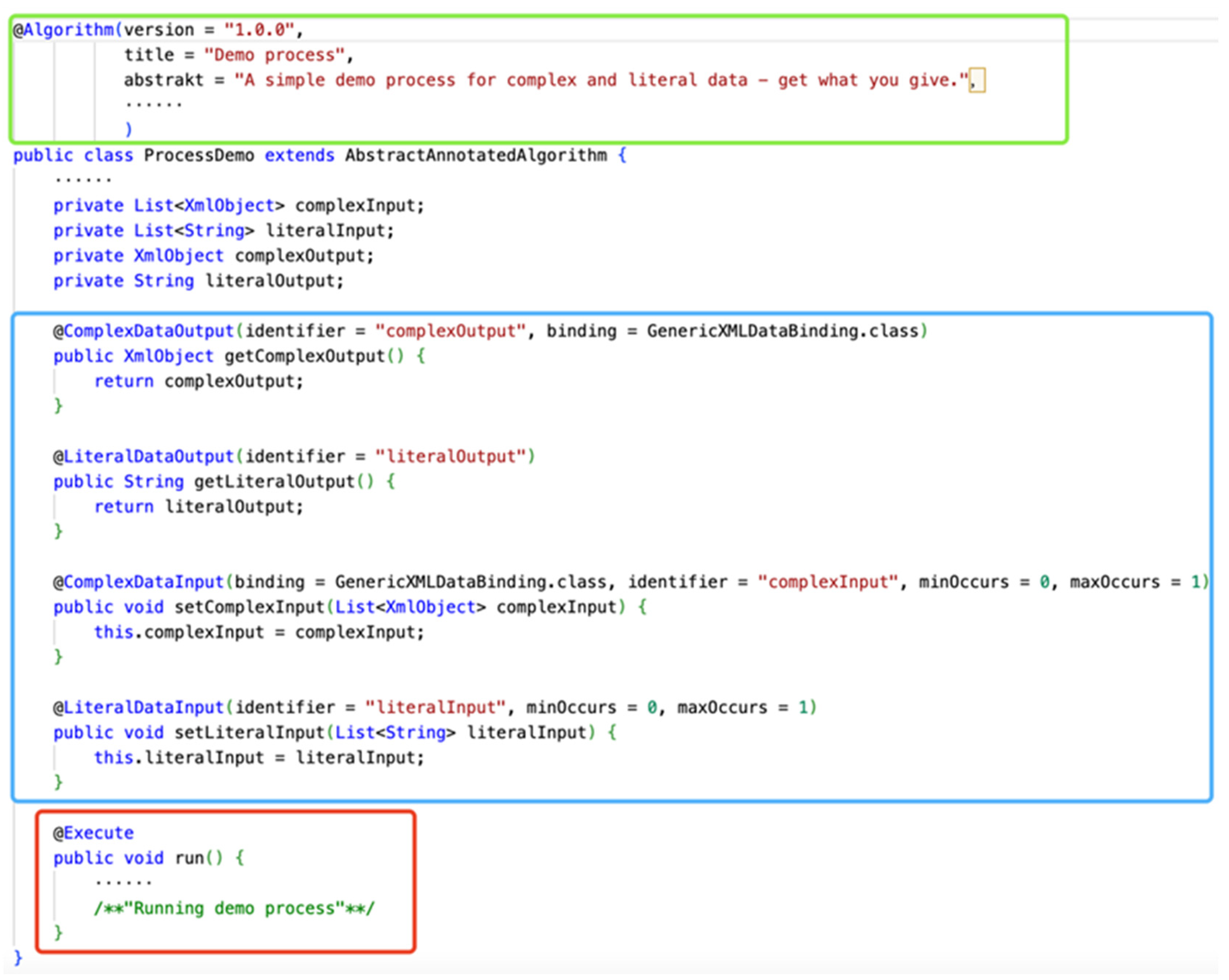
The first is the general process model configuration based on the WPS specification. The configuration file of the process implementation covers all descriptive elements, including data exchange formats. Three common data types were used in the specification to handle input and output data, including LiteralData, BoundingBoxData, and ComplexData. A LiteralData indicates that the input or output is a simple literal value (e.g., integer or string). A BoundingBox data structure is comprised of two parts. One Default-element: referencing the default coordinate reference system (CRS) of the bounding box. One or more Supported-elements: referencing the supported CRSs. The complex data structure is presumably the most used data structure within WPS since it allows the transmitting and receiving data structures like GML or binary data. These three data types provide the necessary information for constraining input and output items, including mimetype, encoding, and schemas. According to Zhang et al., 2020, a general profile provides a generalized process description, and from the perspective of the technical implementation, the configuration file is equivalent to the description of a process [
23]. This is illustrated in
Figure 4. Process and its child elements Input, Output, GenericInput, and GenericOutput all derive from the DescriptionType class, which can be used to express metadata such as title, abstract, keywords, and related terms.
Secondly, based on OGC standards, geospatial data, algorithm models, and other resources can be encapsulated and released as sharable and reusable network resources for users to use or integrate into complex service chains [
24]. Additionally, creating web services takes a lot of time and requires expertise, and many GIS and RS modeling experts prefer to concentrate on creating more reliable models than on strengthening their coding abilities. Therefore, to make it easier to publish local models to web services, this work introduces the “black box” theory of executive encapsulation [
25]. The term “black box” refers to a technique where the user is only aware of the input and output characteristics and the internal implementation is concealed. Using this technique, executable codes created in any programming language can be contained within the appropriate executable files. The configuration file restricts the encapsulation algorithm’s parameters.
Typical model packaging and deployment strategies involve two steps. In the first step, the resource provider submits the accessible models to the model repository after describing them. The second step is for resource providers to register the compute nodes they will be providing with the computing resource pool set up in the modeling environment [
26,
27]. The specific realization method is discussed in
Section 3.2.2.
2.3.2. Constraint Rule-Based Service Composition
The Web Processing Services (WPS) specification, promulgated by the OGC, has been proven to be an effective technique for publishing geospatial processes and constructing integrated model chains [
28]. Model workflows are in fact created to “automate entire or part of workflows”. In general, a chain of interoperable model components can produce richer results than a single model by supporting separate coupled models, exchanging input and output files, and achieving model interoperability [
29]. There are two types of service chains that are frequently used in real applications: one type contacts a single service using a fixed binding, and the other type connects a service using a defined arrangement based on a service chain such as BPEL (Business Process Execution Language). Despite the fact that numerous automatic or semi-automatic service composition techniques have been put forth by researchers, the majority of them necessitate the creation of executable service composition templates first [
30,
31]. After that, the service parameters, interfaces, and metadata are described at the syntax level, services are found through keyword matching, and executable service chains are generated [
32].
In order to support the online construction of dynamic processing services, the primary task is to abstract and encapsulate the many models and algorithms of land cover processing services, publish them as invokable web service interfaces, and form registered algorithm service resources for orchestration to form individualized services. Furthermore, due to the interconnection and dependence of models and algorithms, there is relatively complex collaboration, competition, or complementarity in distinct processing services [
33]. Inconsistent data parameters and similar service functionalities are a couple of the challenges that the dynamic generation of workflow confronts. To ensure that the service chain can be executed without encountering any barriers, we consequently require the conditions under specific rules to confine the service for the impediments present in the interaction. Semantic matching rules are typically used to assess the degree of matching between input or output data from a web service [
34]. The two rules are hasInputRule and hasOutputRule, which can be formally described using Semantic Web Rule Language (SWRL). These rules specify relationships between a service, a profile, and an input or output. The hasInputRule states that if a service presents a profile, and the profile has an input, and the input has a parameter type and is an instance of an owl class (it is used to describe which class an entity belongs to), then the service has an input requirement. The hasOutputRule states that if a service presents a profile, and the profile has an output, and the output has a parameter type and is an instance of an owl class, then the service has an output requirement.
Under rule constraints, the service composition approach usually involves two steps: (1) Construction of constraining rules. (2) Conditional evaluation of the input and output of services. This paper argues that the constraints in the construction of land cover coverage dynamic services are mainly manifested in data. Data format differences, coordinate system differences, and resolution differences are the three main categories of data differences. To eliminate these data differences, we defined three sets of constraint rules: DFinconRules, CSinconRules, and ReinconRules in our previous work [
35], and then used SWRL to formally describe these constraint rules, as shown in
Table 2.
3. Prototype Implementation and Analysis
In order to evaluate the validity and feasibility of the proposed DSCM, a web-based land cover change detection system was developed. In this system, end-users could easily obtain the LCC information according to their different requirements.
3.1. Architecture
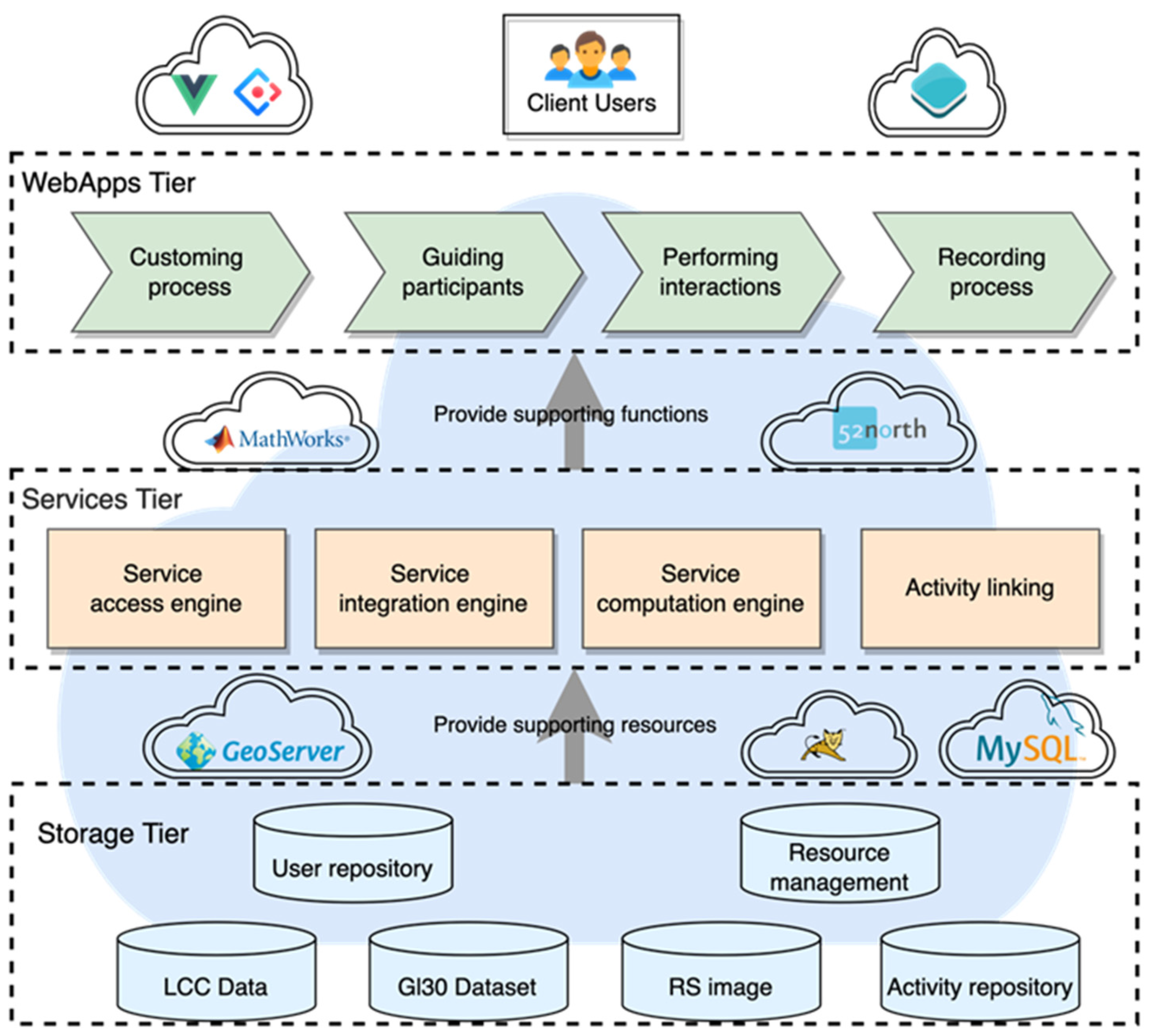
The DSCM prototype system was designed and developed based on SOA and SOC standards and principles. Its primary function is to perform service-oriented dynamic monitoring and visualization for LCC without relying on desktop software. The architecture of the prototype system mainly includes the following three parts, i.e., WebApp Tier, Services Tier, and Storage Tier, which is shown in
Figure 5.
Storage Tier is the basic part of the prototype system. Its main role is to provide change detection data, processing algorithms, and models to support the upper service logic layer. Resource data mainly include remote sensing images, land cover classification data, land cover change data, and other reference data. Data processing tasks cover preprocessing, change information extraction, and postprocessing involved in the change detection process steps.
Services Tier includes LCC data service access engine, LCC data service integration engine, LCC computation engine, and a unified request management interpreter. In the Services Tier, land cover data resources and processing algorithm resources in the Storage Tier are encapsulated into OGC services, which provide support for data services and computing services for the system.
WebApp Tier is the top layer of the structure, including request input, raw data/image data download, online visualization, and further analysis. Its main function is to provide users with a friendly interactive interface so that end users can use it to perform expected online processing to obtain the results of changes in land cover and display the LCC results.
3.2. System Implementation
The server–client model was adopted in the implementation of the prototype system, which is built on a fully open-source infrastructure and open standards. Several development languages and frameworks are used in this system, such as asynchronous JavaScript (Axios) and XML, Java servlet, Web service, JSON, Vue, MATLAB, 52North for Java, Openlayers, Tomcat, Geoserver, etc. The prototype system is now deployed on the server, which can be accessed by any web user in a web browser.
3.2.1. Graphical User Interface
The user interface is built on Vue-CLI scaffolding, UI components Ant Design, and SplitPane to embrace responsive design concepts. The purpose of this design is to make a layout capability similar to desktop GIS, where users can drag and drop panels for better-displaying effects. Three sub-upper panels were developed for facilitating user interaction more conveniently. The first one is used to describe the function of each part to improve the user’s understanding of the model. The second one is used for data processing and system interaction. The third one is used as a console for displaying the output in the geoprocessing. The lower panel contains a map component built based on Openlayers, which is used to display the results of the processing tasks. The visualization interface is shown in
Figure 6.
3.2.2. Service Publish and Data Preparation
Model Deployment and Publish
“Black box” is an approach that can be used without the user knowing how its internal algorithms work, as the user only needs to know the input and output characteristics. Using this method, the executable code written in any programming language can be encapsulated into the corresponding executable file, such as an executable file (EXE), dynamic link library (DLL), Java Archive File (JAR), and various program scripts. It only exposes the interface for input and output data and hides all implementation details. These executable programs are collectively referred to as third-party programs. The ability to call third-party programs is critical to the encapsulation of local models. Certain high-level programming languages have the capability to invoke other programs. For instance, Java can call JAR programs using Runtime or ClassLoader and Python scripts using Runtime, the Python Interpreter, and Jython. Algorithm services could be built in a variety of libraries or languages, including Java and MATLAB, which are compatible with both Windows and Linux cross-platform operating systems. We only retain the readability of its input and output and hide its internal implementation when encapsulating the algorithm service. The 52North framework is utilized for unified management, and the encapsulated algorithm is constrained by the configuration file. Input data and output data can be remote sensing images with various bands, radiations, spectra, or different temporal and spatial resolutions.
Users could understand from the preceding explanation that the configuration file contains information about the process description. In the configuration file, there is also an execution operation. The execution operation allows the WPS client to run a process implementation specified by the server and supports returning output results. Direct input can include executing a request (by value) or referencing a web-accessible resource (by reference). In addition, the output can immediately embed and save a resource that is available via the web, as depicted in
Figure 7, or it can return a response document in the form of XML [
36].
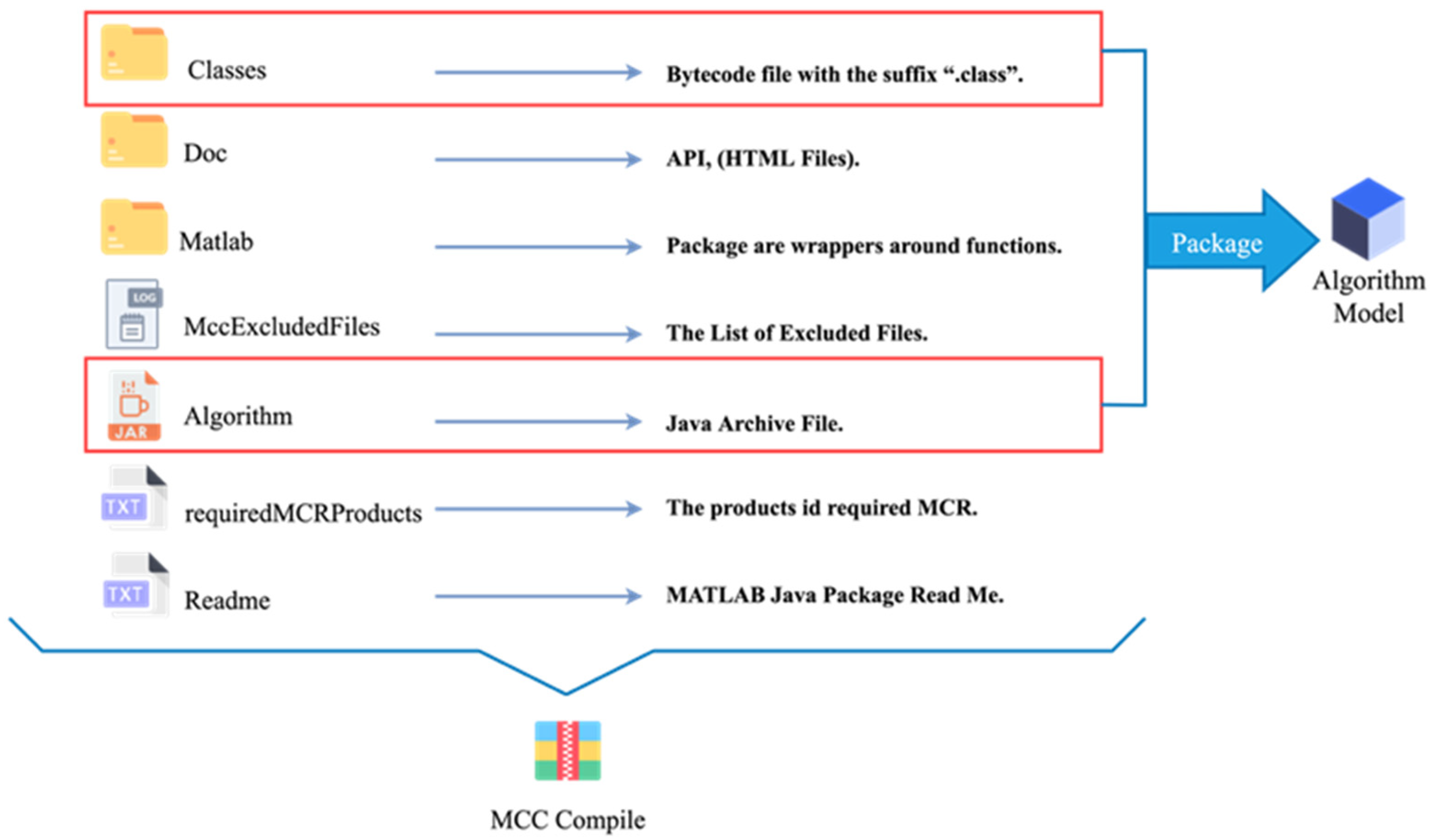
Slightly different from the develop an algorithm, specific programming skills and a lot of time are required for the development of web services. Many specialists would like to concentrate on building more powerful models rather than on the tiresome deployment and release effort. As a consequence, the executable algorithm is further encapsulated in this work. The compiled file is displayed in
Figure 8 after the executable code file was generated using the MATLAB Compiler SDK. After compiling it into a third-party executable program that can be called, add its readable input and output to the configuration file to complete the service configuration. In this way, the reusability and sharing of the algorithm are improved, and at the same time, it provides a solution for the migration of the desktop algorithm.
Land Cover Data Processing Task
The system and part algorithms presently rely on datasets from GlobeLand30, and by following a number of data processing steps, we published the data to the server to guarantee that users can obtain the data online whenever they need it. The primary activities involved in data preprocessing are projection standardization, data classification, and data cleaning. Due to the enormity of the data volume, we used MATLAB tools and ArcGIS Model Builder to complete the data pre-processing and subsequent processes, which also comprise the following operations. Establishing a fishing net element on the target province’s administrative boundaries is the first step. We clipped the data with fishnets to increase the map server’s efficiency and increase the flexibility of the data selection. After cropping, each piece of data was 300×300 pixels in WGS84 coordinates. The second step is to reconcile the raster datasets. All datasets will use the WGS 1984 Mercator projection in order to ensure consistency in geographic coordinate systems [
37]. In order to properly define the GeoTIFF file coordinate system and ensure that all data have the same projection and file format, several MATLAB tools were used simultaneously in this example. The third step is to publish the data as a WMS service. The ImageMosic plug-in in Geoserver is used in this step to publish the data service, since the data have the qualities of a huge amount, wide range, and multi-phase. With Geoserver’s ImageMosaic plug-in, we may mosaic two or more photos and overlay the ones with the same coordinates to create a single, continuous image. In order to achieve the centralized management of LCC data, the data were filtered using the Common Query Language (CQL). Unlike XML’s filtering coding language, CQL is written using a familiar text-based syntax, so it is more readable and suitable for manual creation. We adopted Geoserver when managing and integrating data storage and web user interfaces, which offers an interoperable architecture [
38]. The client consists mostly of two components: a user interface built on the web standards paradigm and the JavaScript map library, which renders raster and vector layers on modern web browsers.
3.2.3. Services Composition
A single service often is unable to satisfy the processing requirements of a user in complicated geoprocessing. In this situation, a particular service chain or workflow must be created by combining several geoprocessing services [
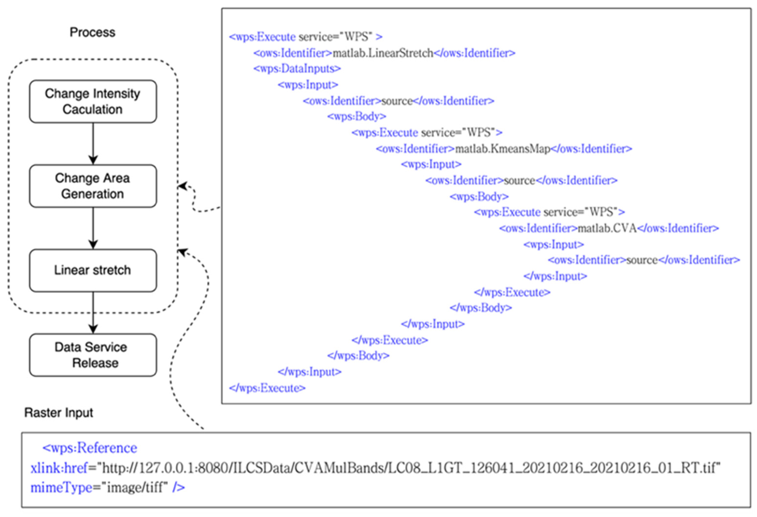
39]. The implementation of the OGC WPS standard served as the foundation for building the model in this study. The model implementation and execution strategies are shown as follows. (1) The model includes an initialization phase, in which execution algorithms can be created and descriptions established on the server according to the WPS definition template file, as shown in
Figure 7, and preliminary calculations can be performed to build a single model. (2) The algorithm includes input and output descriptions, as well as an Execute matching annotation that can be used to execute the algorithm. (3) In order to complete the combination and construction of the service chain, which is based on specified rules, we require it to maintain the input and output of those rules.
We utilized the XML description language to represent the two scenarios that make up the service composition when a client requests a service. The first step is to construct a general plan to achieve the goal, starting from the initial situation and the desired goal. The second is to select a generic plan, identify the necessary services, and create a workflow in which the generic plan node enables the dynamic selection of various services [
40]. Plans for the aforementioned two situations can be used for scenario 2 and scenario 3 of the DSCM, respectively. To accomplish the desired result in DSCM, we must maintain the data in a certain reference format during data transfer from one service to another. For instance, data services, which take the form of network resource references, are required to implement data interchange across services (by Reference). The example fragment of the description template is shown in
Figure 9.
The data flow of the web service composition is the chain of inputs and outputs of the model. The core model execution is a black box, but the related models do not need to have a consistent data format. As a result, according to the constraint rules, a strong and executable service chain can be produced by determining if the input data constraints of a particular service are satisfied. In
Section 2.3.2, we primarily concentrate on the problem of data inconsistency and propose three sets of constraint rules: DFinconRules, CSinconRules, and ReinconRules. To ensure the proper execution of the business chain in the event that the input data are incompatible with the service, the necessary data format conversion (DFC), coordinate system conversion (CSC), resolution conversion (REC), and other preparatory services were chosen. The logical sequence for the service composition process based on constraint rules is as follows: We define a process that creates a list of elements (called
WSChain) based on input values D
init and D
req, and a list of elements called
WSList. The process starts by setting a temporary variable D
temp equal to D
init and initializing
WSChain as an empty list. The process then enters a loop that continues until Dtemp is satisfied by D
req. Within this loop, the code iterates through each element
wsi in
WSList and adds values to
WSChain based on whether D
init satisfies certain conditions (
DFinconRules,
CSinconRules, or
ReinconRules). The element
wsi is also added to
WSChain and, if D
req satisfies the
hasOutputRule condition, the process returns
WSChain as the output. If D
req does not satisfy this condition, D
temp is updated to be equal to
wsi.output. After the loop ends, if D
req does satisfy the
hasOutputRule condition, that rule is added to
WSChain. Finally, the process returns
WSChain as the output, which is the service chain we give our rules to build.
4. Walk-Through Examples
In this section, two distinct scenarios are given for comprehensive land change detection and artificial land change detection, which are used for evaluating the suitability of the proposed DSCM.
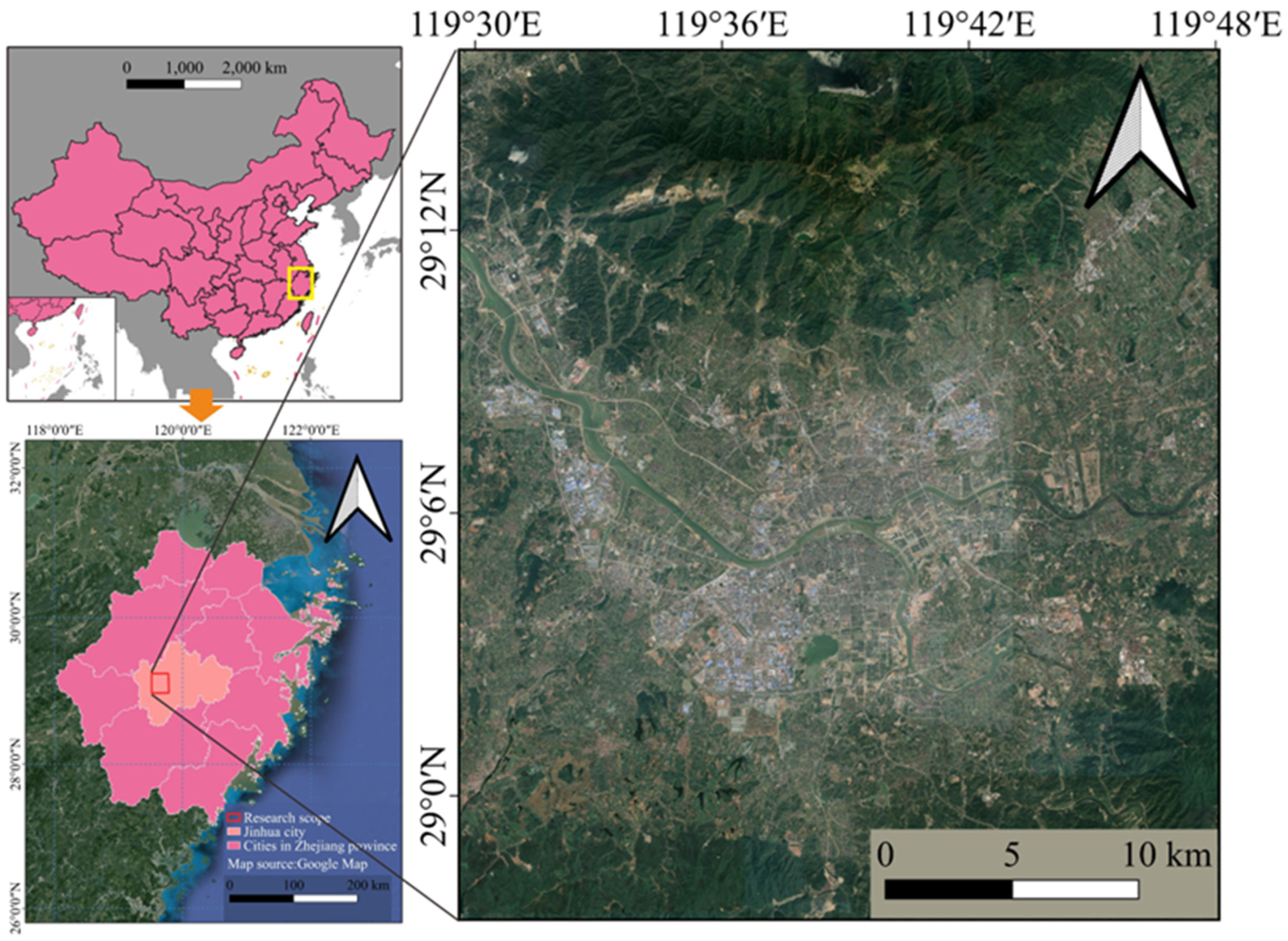
The study area is located in Jinhua City, Zhejiang Province. The geographical location and research area are shown in
Figure 10. According to the research, from 2005 to 2018, the land cover structure of Jinhua City has undergone significant changes. Overall, the area of construction land continued to grow. The area of forest and cultivated land continued to decrease. Grassland and water areas first increased and then decreased. Most of the forest land was converted into cultivated land, and most of the cultivated land was converted into construction land. More than 80% of the construction land is formed by the transfer of cultivated land [
41].
4.1. Artificial Land Cover Change Detection
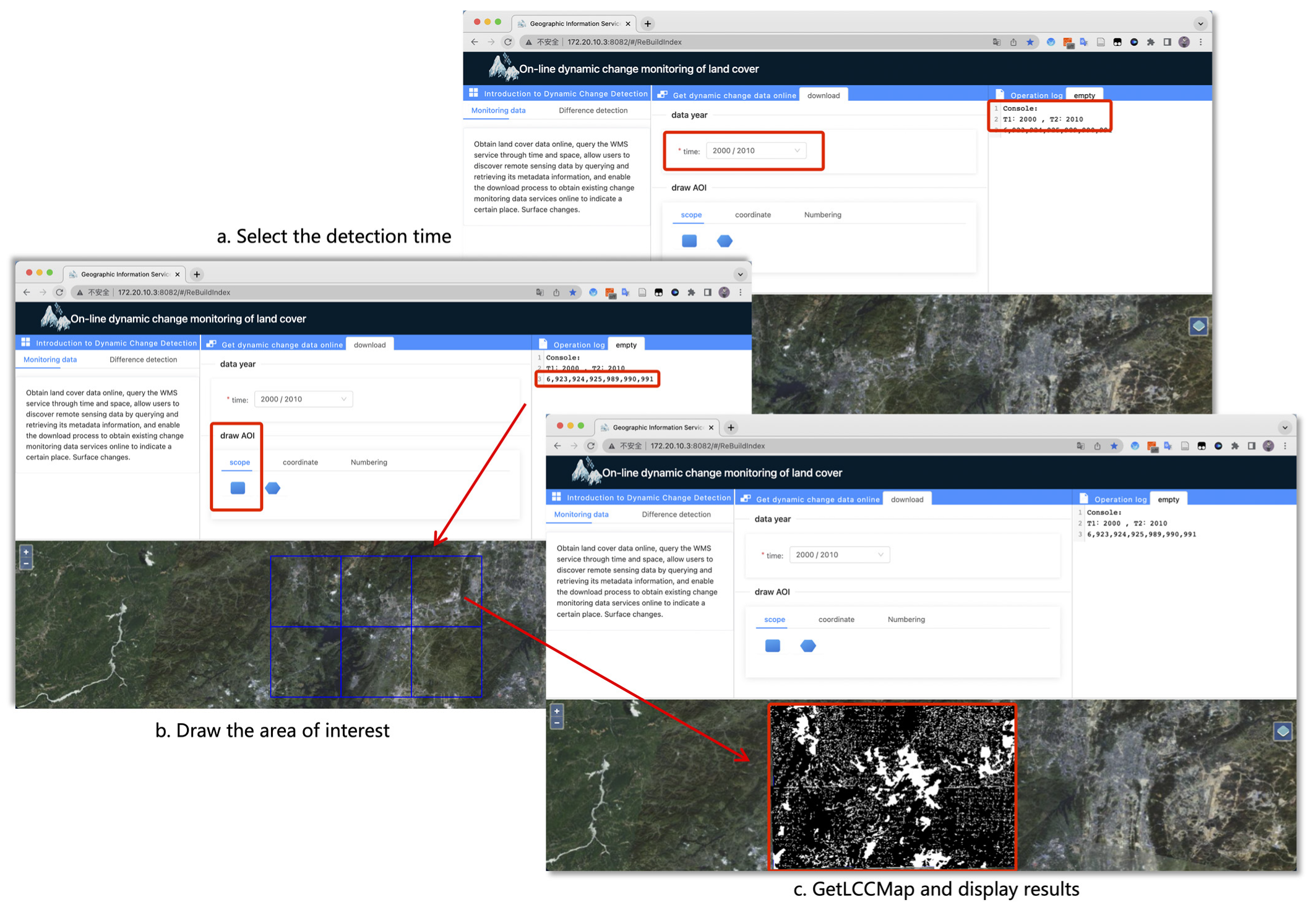
This scenario was used to present a situation where we would like to estimate the change in artificial land cover surrounding the research region between the years 2000 and 2020. With “GetLCCMap”, users can access published change data online, query and retrieve remote sensing data’s metadata, and activate the download process by specifying time, space, type, and other parameters to the WMS service. Access to existing resources through the custom interface indicates land cover change. For example, users can draw the feature coordinates of polygons to create an AOI (Area of Interest), then query the information services in the AOI, and check the available image data across by the metadata to ultimately receive the required LCC raster image file, as shown in
Figure 11.
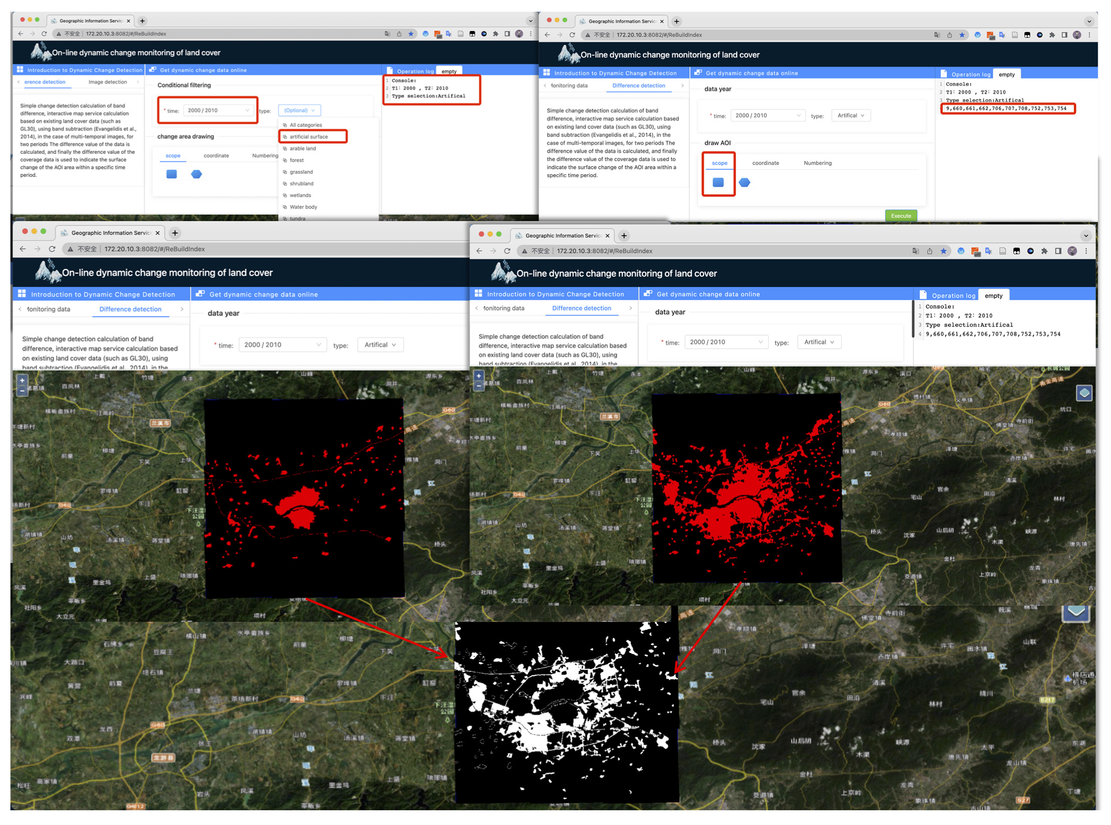
However, it is typically challenging for us to collect the LCC results in some areas directly. The second DSCM strategy utilizes multiple periods of land cover data that have been published to the server to conduct spatial relationship-based geoprocessing change detection through interactive map services. The selection of the time frame and the kind of land cover is done first. Then, as shown in
Figure 12, draw the AOI on the interactive map, click to execute after requesting the data, use band subtraction to calculate the difference between the two image periods [
42], and then use the difference result of the coverage data to indicate the land cover change of the AOI area over time.
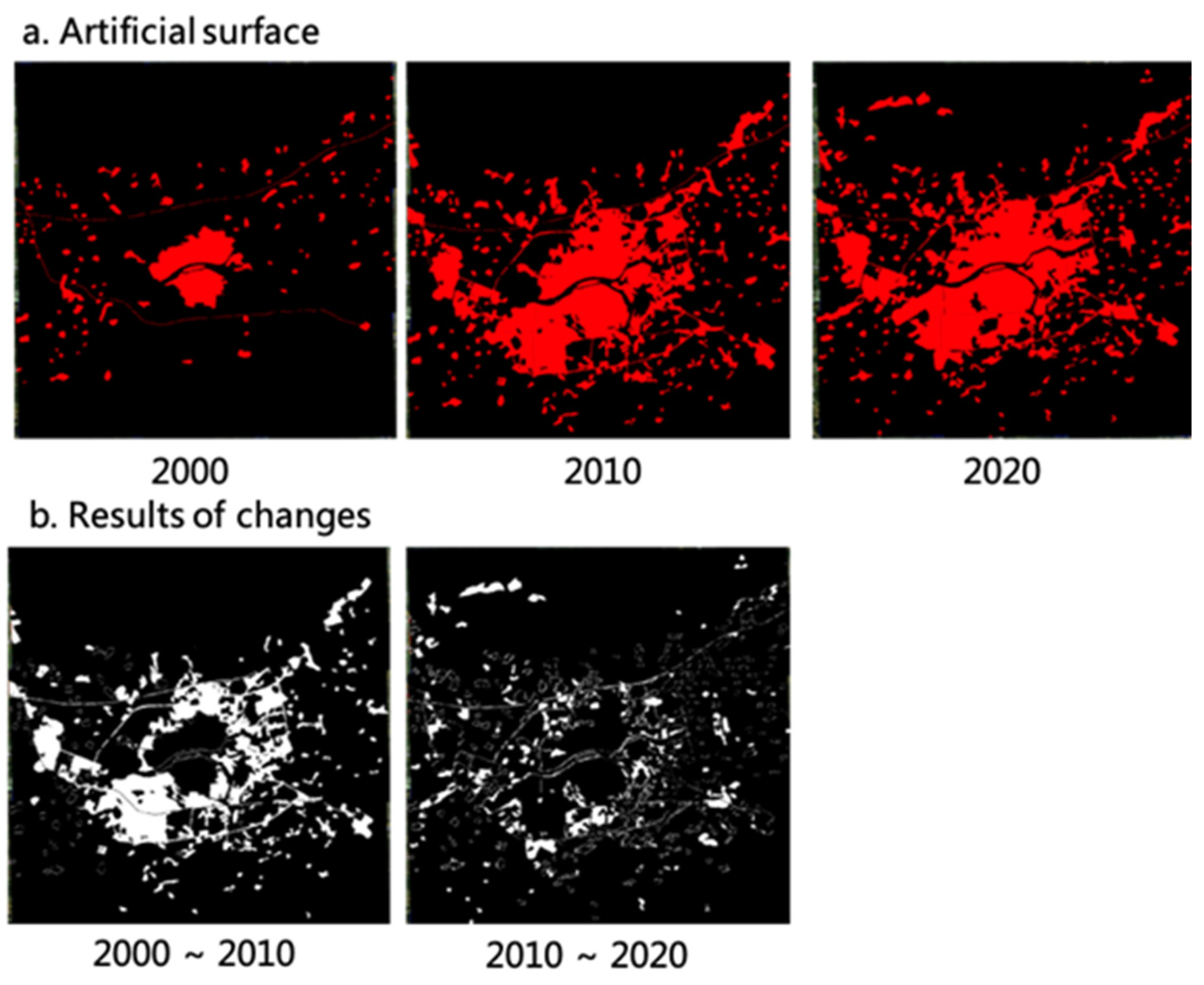
To evaluate both data acquisition and calculations based on band subtraction, we simulated two application scenarios of the dynamic service computing strategy. Two trials were used to detect changes in the land cover of the research region, and the findings of the change analysis are displayed in
Figure 13. From (b), it is clear that the research region underwent significant change between 2000 and 2010, and the artificial land cover rapidly increased. However, between 2010 and 2020, the majority of the growth of man-made types occurred in suburbs and peri-urban areas.
4.2. Comprehensive Land Cover Change Detection
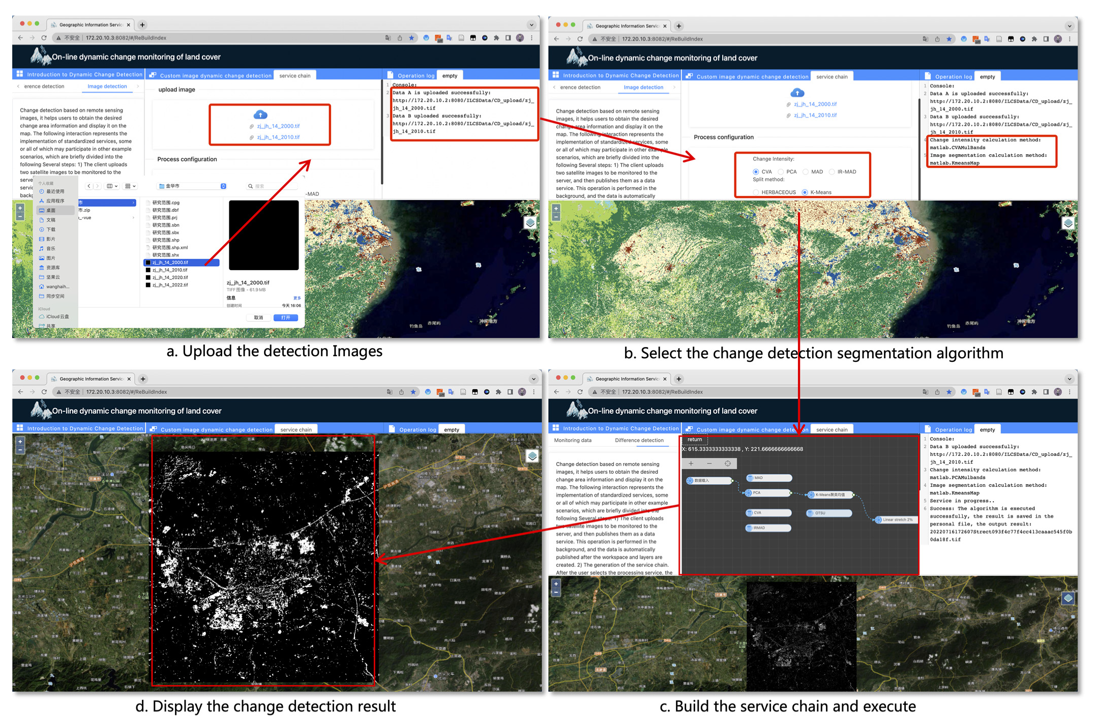
In this section, we demonstrate a use-case scenario for land cover change detection in the study area based on a combination of Landsat imagery and services. We analyzed the land change of the survey area during the three decades from 1990 to 2020 using the third DSCM strategy. Briefly broken down into several parts, the interactions below describe the execution of standardized services, some or all of which may take place in other example scenarios: (1) The user uploads the two satellite images to be analyzed to the server by clicking “Upload Image” and then publishes them as a data service. After the workspace and layers are built, this action is carried out in the back, and the data were automatically published. (2) The user chooses the services for change intensity and change detection computation, builds the service chain for each service, shows the execution process, and creates the associated XML request document. (3) The user selects “Start Execution” to direct the request to the WPS processing engine and transmit it to the request handler. After receiving the input and sending it to the interpreter for evaluation, the WPS processing engine module evaluates the input material and produces a response, which is then sent back to the client via the WPS request processing. (4) Following receipt of the response, the client repeats the data service release from step 1 above. Together, Openlayers and Geoserver overlay the outcome on the interactive map and apply various operations on it.
Figure 14 illustrates how land cover change detection can be used in conjunction with CVA and K-Means algorithms [
43,
44].
The extensive land cover changes in the study area over the previous three decades were successfully simulated by our service-based combination.
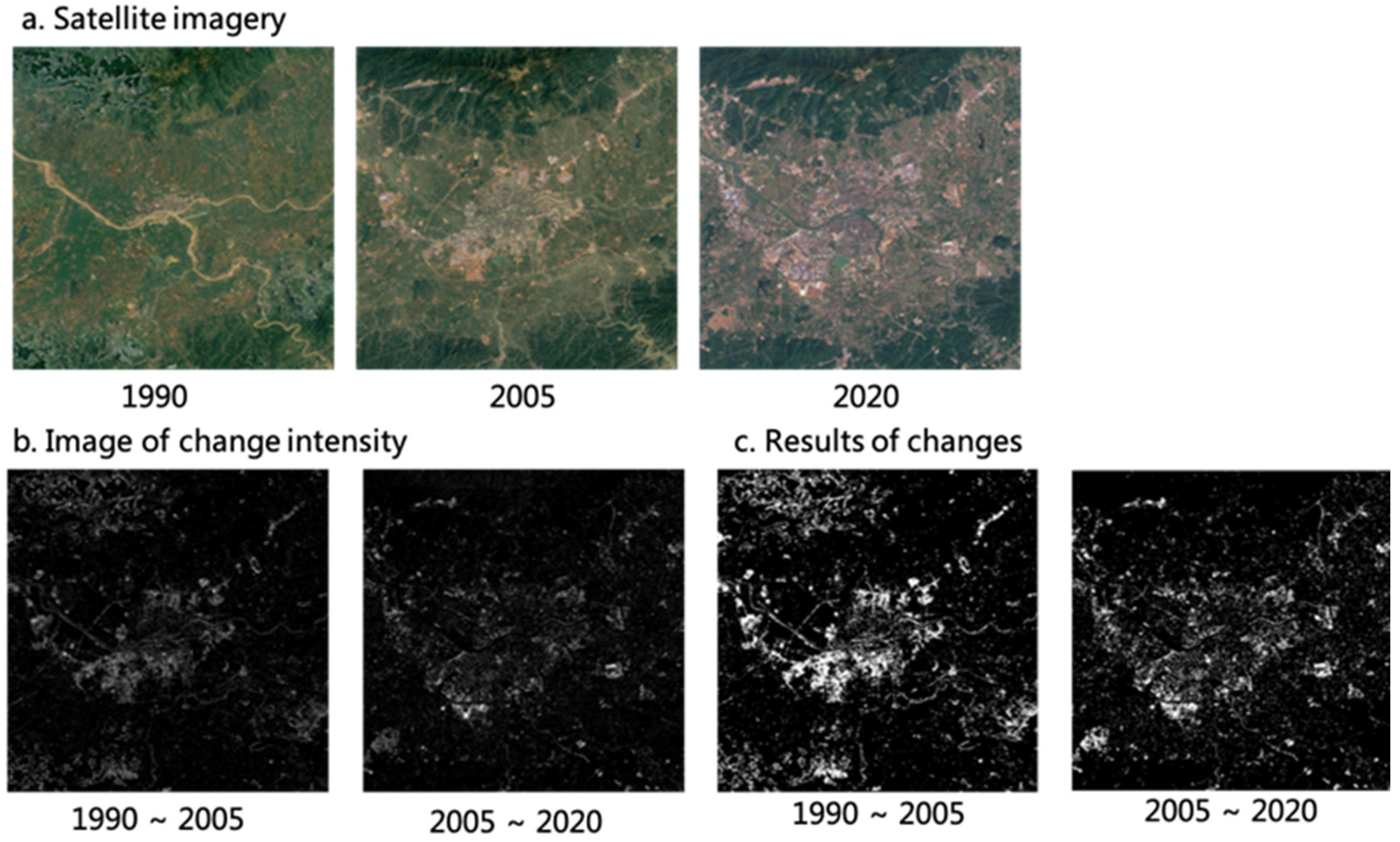
Figure 15 displays the input photos as (a), and (b) display the change intensity images that were produced. The gray value in the changing intensity image is relatively concentrated, and the higher the gray value, the higher the possibility of LCC. The outcomes of the change detection are depicted in (c), the black area in the change detection results is the unchanged area, and the white area is the changed area. In (c), the change regions are primarily concentrated in the city center and the southwest part of the city, showing that the artificial area in the study area increased quickly between 1990 and 2005. The area of change on 2005–2020 is mainly concentrated on the outskirts of urban regions, indicating that the change is spread. Combined with the artificial land cover change detection, it can be inferred that from 2005 to 2020, the pace of change of man-made land cover in the study area gradually slowed down and the change in the proportion of non-man-made land types increased.
In order to verify the reliability of the results, we selected sufficient samples for accuracy evaluation. Among the evaluation process, 1132 ‘changes’ samples and 1503 ‘no-change’ samples were selected for the study area between 1990 to 2005, as well as 1542 and 998 corresponding samples for the study area between 2005 to 2020. The accuracy assessment showed that these two areas achieved an overall accuracy of 0.89 and 0.87 with a kappa coefficient of 0.76 and 0.73, respectively.
5. Discussion
Experimental results demonstrate the feasibility of geoprocessing models and workflows in land cover monitoring. The DSCM includes several change monitoring methods, combines them into a service chain structure, and then generates the dynamic land cover change monitoring application program. This method breaks the constraints of traditional change monitoring. The prototype system accomplishes the deployment of algorithm models and the integration of target resources. Users are no longer dependent on numerous data sets, high-performance computation, or even professional background knowledge.
Due to the lack of a “one-stop” solution in the current study, a dynamic service computing model (DSCM) was proposed in
Section 2.1. Based on the adaptive adjustment of the dynamic service computing model based on user requirements, an ideal land cover change result can be returned to the end user. DSCM consists of three scenarios: (1) If LCC data are already available and in existence, we request WMS to access or download it through the “GetLCCMap” method as intended. (2) For the absence of LCC data but the existence of two-phase land cover data, LCC data were generated based on spatial relationship geoprocessing. (3) In the absence of LCC data and land cover data, use remote sensing images combined with service combinations to generate LCC data. To ensure that end users may browse and download information about land cover change with less expertise, based on the implementation of the DSCM prototype system. This research covers the issues with interaction mode, data integration, professional barriers, and other issues in online change monitoring with the use of the OGC standard service specification, integrated with web service technology and workflow technology. A number of online change detection strategies and a new dynamic service change monitoring procedure were proposed based on these issues.
The major results of this dynamic service-computed land cover detection method, based on actual applications and our expertise, are as follows:
(1) Information dynamic integration and geoprocessing dynamic construction: To facilitate dynamic generation according to spatial scope and time, a special LCC data interface was designed, and the cross-platform loosely coupled integration of diverse land cover information resources was realized. Existing classification results in the registration library can be searched by user’s needs and realize on-demand personalized resource obtain. In addition, users can easily and independently publish data and transform their individual accomplishments into online service resources with the aid of online information integration tools, per the unified service description expression paradigm. With the support of the three strategies in
Section 2.1, users can construct customized processing services through automatic service composition and organization by selecting the optimal model and algorithm based on their own needs.
(2) Removing obstacles for non-expert users to use web services to analyze land cover changes. In the interactive mode, the design mode minimizes technical jargon and is more approachable to laypeople. Users do not need to have programming or remote sensing expertise to carry out particular activities.
(3) Promote the sharing and customization of models: The framework that was devised makes it possible for a wider range of individuals to take part in the data sharing process. In the near future, the framework will be able to share both data resources and data processing techniques, with realization of individual solutions for the field of land cover.
(4) Operational cross-platform support: The Java-based DSCM platform, which supports major operating systems such Windows, MacOS, and Linux, is cross-platform software, therefore this solution works with them all.
6. Conclusions
This paper proposed an online interoperable dynamic service computing model, and developed a prototype system based on the model, which demonstrates and validates the online land cover change monitoring. We achieved web service posting and visualization of processing jobs for processing results, using the black box theory to encapsulate the processing services. Using the GlobeLand30 data sets and Landsat imagery, the system is being built and tested concurrently. Additionally, the system integrates service chain generation under the constraints of rules, which is an efficient approach to build models with web services.
Two walk-through examples were used to evaluate the efficiency and operability of the proposed model and system. The model and system can assist researchers in obtaining the desired results for land change dynamically in near real-time away. The ability of the geoprocessing engine depends on the amount of computer cores, and all processing is implemented on the server side, which can significantly lessen the strain on local computing resources. The DSCM prototype system can provide great convenience for ordinary users, which allows for easy access to and processing of LCC data.
Despite the advantages of the proposed model and system, some shortcomings still exist, which should be further improved. First, more types of LCC algorithms need to be published as web processing services to support a variety of LCC processing and applications, such as deep learning algorithms. Second, syntax, semantic, and pragmatic information need to be enhanced for more intelligent LCC processing. Third, the web-based driving force analysis of LCC will be further expanded to the DSCM with the support of social, humanistic, and economic data.
Author Contributions
Conceptualization, H.X. and D.H.; Methodology, H.X. and H.W.; software and data curation, H.W.; validation, H.W. and J.Z.; resources, H.W.; writing—original draft preparation, H.W.; writing—review and editing, H.X., D.H. and H.W.; visualization, H.W.; supervision and project administration and funding acquisition, H.X. All authors have read and agreed to the published version of the manuscript.
Funding
This paper is jointly funded by the Shandong Provincial Natural Science Foundation (No. ZR2022YQ36), Hunan Provincial Natural Science Foundation of China (2021JJ40721) and Open Fund of State Laboratory of Information Engineering in Surveying, Mapping and Remote Sensing, Wuhan University (20S01).
Institutional Review Board Statement
Not applicable.
Informed Consent Statement
Not applicable.
Data Availability Statement
Not applicable.
Acknowledgments
The authors would like to thank the editors and the anonymous reviewers for their constructive comments and suggestions, which greatly helped to improve the quality of the manuscript.
Conflicts of Interest
The authors declare no conflict of interest.
References
- Zhao, M.; Xu, T. Research on the Environmental Impacts of Land Use and Land Cover Change. Res. Soil Water Conserv. 2005, 12, 43–45. [Google Scholar]
- Mahmood, R.; Pielke, R.A.; Hubbard, K.G.; Niyogi, D.; Bonan, G.; Lawrence, P.; McNider, R.; McAlpine, C.; Etter, A.; Gameda, S.; et al. Impacts of Land Use/Land Cover Change on Climate and Future Research Priorities. Bull. Am. Meteorol. Soc. 2010, 91, 37–46. [Google Scholar] [CrossRef]
- Meyer, W.B.; Turner, B.L. Human Population Growth and Global Land-Use/Cover Change. Annu. Rev. Ecol. Syst. 1992, 23, 39–61. [Google Scholar] [CrossRef]
- Zhao, Q.; Wen, Z.; Chen, S.; Ding, S.; Zhang, M. Quantifying Land Use/Land Cover and Landscape Pattern Changes and Impacts on Ecosystem Services. Int. J. Environ. Res. Public Health 2020, 17, 126. [Google Scholar] [CrossRef]
- Du, P.; Wang, X.; Chen, D.; Liu, S.; Lin, C.; Meng, Y. An Improved Change Detection Approach Using Tri-Temporal Logic-Verified Change Vector Analysis. ISPRS J. Photogramm. Remote Sens. 2020, 161, 278–293. [Google Scholar] [CrossRef]
- Li, Z.; Shi, W.; Zhu, Y.; Zhang, H.; Hao, M.; Cai, L. Subpixel Change Detection Based on Radial Basis Function with Abundance Image Difference Measure for Remote Sensing Images. Remote Sens. 2021, 13, 868. [Google Scholar] [CrossRef]
- Zhu, L.; Xing, H.; Hou, D. Analysis of Carbon Emissions from Land Cover Change during 2000 to 2020 in Shandong Province, China. Sci. Rep. 2022, 12, 8021. [Google Scholar] [CrossRef]
- Cao, D.; Xing, H.; Wong, M.S.; Kwan, M.-P.; Xing, H.; Meng, Y. A Stacking Ensemble Deep Learning Model for Building Extraction from Remote Sensing Images. Remote Sens. 2021, 13, 3898. [Google Scholar] [CrossRef]
- Hou, D.; Wang, S.; Tian, X.; Xing, H. PCLUDA: A Pseudo-Label Consistency Learning- Based Unsupervised Domain Adaptation Method for Cross-Domain Optical Remote Sensing Image Retrieval. IEEE Trans. Geosci. Remote Sens. 2023, 61, 1–14. [Google Scholar] [CrossRef]
- Xing, H.; Liu, C.; Li, R.; Wang, H.; Zhang, J.; Wu, H. Domain Constraints-Driven Automatic Service Composition for Online Land Cover Geoprocessing. ISPRS Int. J. Geo-Inf. 2022, 11, 629. [Google Scholar] [CrossRef]
- Hou, D.; Wang, S.; Tian, X.; Xing, H. An Attention-Enhanced End-to-End Discriminative Network With Multiscale Feature Learning for Remote Sensing Image Retrieval. IEEE J. Sel. Top. Appl. Earth Obs. Remote Sens. 2022, 15, 8245–8255. [Google Scholar] [CrossRef]
- Lu, M.; Bi, Y.; Xue, B.; Hu, Q.; Zhang, M.; Wei, Y.; Yang, P.; Wu, W. Genetic Programming for High-Level Feature Learning in Crop Classification. Remote Sens. 2022, 14, 3982. [Google Scholar] [CrossRef]
- Wen, C.; Lu, M.; Bi, Y.; Zhang, S.; Xue, B.; Zhang, M.; Zhou, Q.; Wu, W. An Object-Based Genetic Programming Approach for Cropland Field Extraction. Remote Sens. 2022, 14, 1275. [Google Scholar] [CrossRef]
- Khattar, R.; Hales, R.; Ames, D.P.; Nelson, E.J.; Jones, N.L.; Williams, G. Tethys App Store: Simplifying Deployment of Web Applications for the International GEOGloWS Initiative. Environ. Model. Softw. 2021, 146, 105227. [Google Scholar] [CrossRef]
- Afaq, Y.; Manocha, A. Analysis on Change Detection Techniques for Remote Sensing Applications: A Review. Ecol. Inform. 2021, 63, 101310. [Google Scholar] [CrossRef]
- Ghaderpour, E.; Vujadinovic, T. Change Detection within Remotely Sensed Satellite Image Time Series via Spectral Analysis. Remote Sens. 2020, 12, 4001. [Google Scholar] [CrossRef]
- Tewkesbury, A.P.; Comber, A.J.; Tate, N.J.; Lamb, A.; Fisher, P.F. A Critical Synthesis of Remotely Sensed Optical Image Change Detection Techniques. Remote Sens. Environ. 2015, 160, 1–14. [Google Scholar] [CrossRef]
- Zhu, Z.; Qiu, S.; Ye, S. Remote Sensing of Land Change: A Multifaceted Perspective. Remote Sens. Environ. 2022, 282, 113266. [Google Scholar] [CrossRef]
- MohanRajan, S.N.; Loganathan, A.; Manoharan, P. Survey on Land Use/Land Cover (LU/LC) Change Analysis in Remote Sensing and GIS Environment: Techniques and Challenges. Environ. Sci. Pollut. Res. 2020, 27, 29900–29926. [Google Scholar] [CrossRef]
- Pandey, P.C.; Koutsias, N.; Petropoulos, G.P.; Srivastava, P.K.; Ben Dor, E. Land Use/Land Cover in View of Earth Observation: Data Sources, Input Dimensions, and Classifiers—A Review of the State of the Art. Geocarto Int. 2021, 36, 957–988. [Google Scholar] [CrossRef]
- Xiao, D.; Chen, M.; Lu, Y.; Yue, S.; Hou, T. Research on the Construction Method of the Service-Oriented Web-SWMM System. IJGI Int. J. Geo-Inf. 2019, 8, 268. [Google Scholar] [CrossRef]
- Wen, Y.; Yue, S.; Zheng, P.; Peng, G.; Lü, G. A Model-Service Deployment Strategy for Collaboratively Sharing Geo-Analysis Models in an Open Web Environment. Int. J. Digit. Earth 2016, 10, 405–425. [Google Scholar] [CrossRef]
- Zhang, M.; Jiang, L.; Zhao, J.; Yue, P.; Zhang, X. Coupling OGC WPS and W3C PROV for Provenance-Aware Geoprocessing Workflows. Comput. Geosci. 2020, 138, 104419. [Google Scholar] [CrossRef]
- Granell, C.; Díaz, L.; Gould, M. Service-Oriented Applications for Environmental Models: Reusable Geospatial Services. Environ. Model. Softw. 2010, 25, 182–198. [Google Scholar] [CrossRef]
- Chen, Z.; Lin, H.; Chen, M.; Liu, D.; Bao, Y.; Ding, Y. A Framework for Sharing and Integrating Remote Sensing and GIS Models Based on Web Service. Sci. World J. 2014, 2014, e354919. [Google Scholar] [CrossRef]
- Li, H.; Zhang, C.; Xiao, Z.; Chen, M.; Lu, D.; Liu, S. A Web-Based Geo-Simulation Approach Integrating Knowledge Graph and Model-Services. Environ. Model. Softw. 2021, 144, 105160. [Google Scholar] [CrossRef]
- Zhang, F.; Chen, M.; Wang, M.; Wang, Z.; Zhang, S.; Yue, S.; Wen, Y.; Lü, G. A Framework on Task Configuration and Execution for Distributed Geographical Simulation. Int. J. Digit. Earth 2021, 14, 1103–1125. [Google Scholar] [CrossRef]
- Castronova, A.M.; Goodall, J.L.; Elag, M.M. Models as Web Services Using the Open Geospatial Consortium (OGC) Web Processing Service (WPS) Standard. Environ. Model. Softw. 2013, 41, 72–83. [Google Scholar] [CrossRef]
- Belete, G.F.; Voinov, A.; Laniak, G.F. An Overview of the Model Integration Process: From Pre-Integration Assessment to Testing. Environ. Model. Softw. 2017, 87, 49–63. [Google Scholar] [CrossRef]
- Zhang, F.; Chen, M.; Yue, S.; Wen, Y.; Lü, G.; Li, F. Service-Oriented Interface Design for Open Distributed Environmental Simulations. Environ. Res. 2020, 191, 110225. [Google Scholar] [CrossRef]
- Santoro, M.; Mazzetti, P.; Nativi, S. The VLab Framework: An Orchestrator Component to Support Data to Knowledge Transition. Remote Sens. 2020, 12, 1795. [Google Scholar] [CrossRef]
- Zhang, M.; Jiang, L.; Yue, P.; Gong, J. Interoperable Web Sharing of Environmental Models Using OGC Web Processing Service and Open Modeling Interface (OpenMI). Environ. Model. Softw. 2020, 133, 104838. [Google Scholar] [CrossRef]
- Chen, J.; Wu, H.; Li, S.; Liao, A.; He, C.; Peng, S. Temporal Logic and Operation Relations Based Knowledge Representation for Land Cover Change Web Services. ISPRS J. Photogramm. Remote Sens. 2013, 83, 140–150. [Google Scholar] [CrossRef]
- Scheider, S.; Ballatore, A. Semantic Typing of Linked Geoprocessing Workflows. Int. J. Digit. Earth 2018, 11, 113–138. [Google Scholar] [CrossRef]
- Xing, H.; Chen, J.; Wu, H.; Hou, D. A Web Service-Oriented Geoprocessing System for Supporting Intelligent Land Cover Change Detection. IJGI Int. J. Geo-Inf. 2019, 8, 50. [Google Scholar] [CrossRef]
- Chang, Y.-S.; Park, H.-D. XML Web Service-based Development Model for Internet GIS Applications. Int. J. Geogr. Inf. Sci. 2007, 20, 371–399. [Google Scholar] [CrossRef]
- González, D.A.; Gleeson, J.; McCarthy, E. Designing and Developing a Web Tool to Support Strategic Environmental Assessment. Environ. Model. Softw. 2019, 111, 472–482. [Google Scholar] [CrossRef]
- Binh, T.T.; Truong, H.L.; Long, D.T. A WebGIS Solution for Estimation Landuse Affected by Salinity Intrusion: Case Study in Ben Tre Province, Vietnam. J. Geogr. Inf. Syst. 2020, 12, 188–201. [Google Scholar] [CrossRef]
- Sheng, Q.Z.; Qiao, X.; Vasilakos, A.V.; Szabo, C.; Bourne, S.; Xu, X. Web Services Composition: A Decade’s Overview. Inf. Sci. 2014, 280, 218–238. [Google Scholar] [CrossRef]
- Dustdar, S.; Schreiner, W. A Survey on Web Services Composition. Int. J. Web Grid Serv. 2005, 1, 1–30. [Google Scholar] [CrossRef]
- Huang, S.; Xi, F.; Chen, Y.; Gao, M.; Pan, X.; Ren, C. Land Use Optimization and Simulation of Low-Carbon-Oriented—A Case Study of Jinhua, China. Land 2021, 10, 1020. [Google Scholar] [CrossRef]
- Evangelidis, K.; Ntouros, K.; Makridis, S.; Papatheodorou, C. Geospatial Services in the Cloud. Comput. Geosci. 2014, 63, 116–122. [Google Scholar] [CrossRef]
- Xing, H.; Zhu, L.; Chen, B.; Zhang, L.; Hou, D.; Fang, W. A Novel Change Detection Method Using Remotely Sensed Image Time Series Value and Shape Based Dynamic Time Warping. Geocarto Int. 2021, 1–18. [Google Scholar] [CrossRef]
- Xing, H.; Zhu, L.; Feng, Y.; Wang, W.; Hou, D.; Meng, F.; Ni, Y. An Adaptive Change Threshold Selection Method Based on Land Cover Posterior Probability and Spatial Neighborhood Information. IEEE J. Sel. Top. Appl. Earth Obs. Remote Sens. 2021, 14, 11608–11621. [Google Scholar] [CrossRef]
| Disclaimer/Publisher’s Note: The statements, opinions and data contained in all publications are solely those of the individual author(s) and contributor(s) and not of MDPI and/or the editor(s). MDPI and/or the editor(s) disclaim responsibility for any injury to people or property resulting from any ideas, methods, instructions or products referred to in the content. |
© 2023 by the authors. Licensee MDPI, Basel, Switzerland. This article is an open access article distributed under the terms and conditions of the Creative Commons Attribution (CC BY) license (https://creativecommons.org/licenses/by/4.0/).


