Article

Characterisation of Banana Plant Growth Using High-Spatiotemporal-Resolution Multispectral UAV Imagery

1
Applied Agricultural Remote Sensing Centre, University of New England, Armidale, NSW 2351, Australia
2
Remote Sensing Research Centre, School of Earth and Environmental Sciences, University of Queensland, St. Lucia, QLD 4072, Australia
3
Hydrology, Agricultural and Land Observation, Water Desalination and Reuse Center, King Abdullah University of Science and Technology, Thuwal 23955-6900, Saudi Arabia
4
Food Agility Cooperative Research Centre Ltd., Pitt St Sydney, NSW 2001, Australia
5
Precision Agriculture Research Group, University of New England, Armidale, NSW 2351, Australia
*
Author to whom correspondence should be addressed.
Remote Sens. 2023, 15(3), 679; https://doi.org/10.3390/rs15030679
Submission received: 11 November 2022 / Revised: 15 January 2023 / Accepted: 19 January 2023 / Published: 23 January 2023

Abstract

:
The determination of key phenological growth stages of banana plantations, such as flower emergence and plant establishment, is difficult due to the asynchronous growth habit of banana plants. Identifying phenological events assists growers in determining plant maturity, and harvest timing and guides the application of time-specific crop inputs. Currently, phenological monitoring requires repeated manual observations of individual plants’ growth stages, which is highly laborious, time-inefficient, and requires the handling and integration of large field-based data sets. The ability of growers to accurately forecast yield is also compounded by the asynchronous growth of banana plants. Satellite remote sensing has proved effective in monitoring spatial and temporal crop phenology in many broadacre crops. However, for banana crops, very high spatial and temporal resolution imagery is required to enable individual plant level monitoring. Unoccupied aerial vehicle (UAV)-based sensing technologies provide a cost-effective solution, with the potential to derive information on health, yield, and growth in a timely, consistent, and quantifiable manner. Our research explores the ability of UAV-derived data to track temporal phenological changes of individual banana plants from follower establishment to harvest. Individual plant crowns were delineated using object-based image analysis, with calculations of canopy height and canopy area producing strong correlations against corresponding ground-based measures of these parameters (R2 of 0.77 and 0.69 respectively). A temporal profile of canopy reflectance and plant morphology for 15 selected banana plants were derived from UAV-captured multispectral data over 21 UAV campaigns. The temporal profile was validated against ground-based determinations of key phenological growth stages. Derived measures of minimum plant height provided the strongest correlations to plant establishment and harvest, whilst interpolated maxima of normalised difference vegetation index (NDVI) best indicated flower emergence. For pre-harvest yield forecasting, the Enhanced Vegetation Index 2 provided the strongest relationship (R2 = 0.77) from imagery captured near flower emergence. These findings demonstrate that UAV-based multitemporal crop monitoring of individual banana plants can be used to determine key growing stages of banana plants and offer pre-harvest yield forecasts.

1. Introduction

Accurate and efficient crop monitoring is an important aspect of productive agriculture, as it supports more effective management decisions which in turn drive efficiency and improvements in production. Monitoring plants’ physiology, morphology, and phenology can indicate age, stress, and growth. This, together with the influence of abiotic and biotic stresses, can inform important decisions surrounding irrigation, fertilizer and pesticide applications. Longer-term monitoring can be used to identify and forecast key aspects of plant growth in order to better understand seasonal and temporal growth trends and make more informed predictions of yield [1]. Traditional monitoring of banana crops is highly labour-intensive and includes in-field visual appraisal and assessment. Input and scheduling are often rudimentary, with manually placed plant markers and manual records guiding the timing of activities [2,3]. Success typically relies on manager experience or the deployment of seasonal labour, which can be subjective, inconsistent, and lacking rigour. Improvements in monitoring efficiency that can provide greater consistency and guidance on the scheduling of inputs and corrective actions would therefore be beneficial.
Banana plants are considered perennial, with the visible vegetative above ground (aerial) plant growing from an underground corm that produces successive plants throughout its life. Each banana plant produces a single bunch of fruit and is cut down when harvested. Whether harvested or left unharvested, the plant (referred to as a mother) is determinate, subsequently dying on bunch completion with a new plant (often referred to as a follower, sucker, or child) becoming the next successive generation. Over time, several follower plants can emerge from a corm, with the farmer selecting the optimal plant as the next generation, removing unwanted follower plants (called de-suckering) to reduce vegetative growth, boost production, and maintain row alignment for vehicle access. Typically, under commercial farming, only one follower per corm is selected, with two vegetative plants present at any one time throughout the bunch cycle [3].
Plant development includes the vegetative phase, at which time the plant is focused on leaf emergence and rapid vegetative growth (denoted by progression between H and E in Figure 1), and then the reproductive phase, during which time the plant’s emphasis is on floral and fruit development [4]. The early reproductive phase is unseen, as flower development is initiated with the flower moving up the centre of the pseudostem, which has been reported to take anywhere between 12–26 weeks [5,6]. Flower spike emergence coincides with the plant having its maximum leaf area [6] (approximately 25–30 m2) through the combination of the highest number of functional leaves (10–15 leaves), the largest leaf size, and the most persistent leaves, which generally remain on the plant for at least three times longer than prior leaves, increasing their exposure to potential biotic and abiotic harm [5]. As the banana plant grows, each successive leaf generally becomes larger in width and length until flowering [7] As this process continues, a pseudostem is created by leaf sheaths, causing the banana plant to gain height and stem width [6]. After inflorescence and subsequent fruit production (between E and H1 in Figure 1), the leaf size and area are greatly reduced (leaf emergence normally halts altogether) and the plant dies (H1 in Figure 1) [5,6]. Although cooler temperatures slow growth, banana plants can produce fruit year-round and maintain an indistinct seasonal harvest period. In-field individual plant phenological growth is asynchronous with greater variability as the crop ages, caused by plant growth characteristics and management decisions [2,5]. The farmer harvest regime, follower timing, and follower selection influence this asynchronous behaviour, and so too do abiotic and biotic factors and phenotypic differences between plants [2]. Prediction of growth is hampered by flower initiation and emergence not being predicted by common crop monitoring practices, such as growing degree days (GDD), age, and obvious morphological changes. As flower initiation is internal, growth timing is less predictable, making the timing of management actions, such as targeted fertilization, during flower initiation unreliable.
Remote sensing can provide important crop-monitoring information, suited to short-term assessment [8] and longer-term trend analysis and detection of phenophases based on multitemporal data collection [9,10,11]. The use of remote sensing technologies may aid the planning and management decisions in agricultural crop production through the provision of actionable and near-real-time information [12]. Remote sensing applications that have been used to extract morphological attributes in other crops include light detection and ranging (LiDAR) and structure-from-motion (SfM) of optical image data [13,14,15,16,17,18]. Physiological attributes can be remotely sensed using multi- and hyperspectral sensors [14,19] and can be used for yield estimation [20,21] and pest and disease monitoring [8,22,23,24], which can aid the scheduling of management activities and corrective actions such as irrigation, fertilizer application, pest control, and harvest planning. During periods of phenological stress, plants adjust nutrient uptake and their growth [25,26,27]. Banana-plant-specific morphological attributes, such as height, leaf area, biomass, and crown size [28], as well as physiological attributes, including leaf biochemical composition and internal structure, can be linked to plant health, vigour, disease, disease susceptibility, and yield [29,30]. Plant age and phenology can be characterized by plant size, individual leaf area, leaf number, and associated overall crown size, all of which are at their peak at flower emergence [31].
Scheduling remote sensing data captures for whole-of-field monitoring is possible for crops that have defined growing seasons. However, specific monitoring schedules are less suitable for banana crops due to asynchronous growth [2,25]. Unlike tree crops, banana plants lack a fixed woody trunk and branch structure, with each plant generation emerging from a different location on the parent corm with subsequent changes in crown position. Crown morphology is also quite variable and changes throughout the day, as the physical crown consists of large, flexible leaves easily moved and readily shredded by wind. Leaves also fold downward along the midrib following a diurnal pattern, causing variations in canopy cover and shape throughout the day [32,33,34,35]. Banana plant attributes of unsynchronized growth, a non-woody structure, a mobile crown, and variable appearances (irregular shape) make satellite and piloted aircraft remote sensing platforms less desirable due to the need for frequent revisits, data captures at certain times of the day, and the need for high spatial resolution, with all of these factors increasing acquisition costs. Existing studies on banana crops utilizing satellite- and conventional-aircraft-based remote sensing focus on the detection of stands and crops of bananas [34,36] rather than individual plant monitoring and assessment. Recently identified studies include the monitoring of crop response to rainfall and temperature change using MODIS (250 m spatial resolution) [37] and mapping banana crop productivity using Worldview 3 (50 cm spatial resolution) [38], from which the authors consider the need for a higher spatial resolution to monitor disease and productivity of banana plants.
Unoccupied aerial vehicles (UAV)—also referred to as drones, unmanned aerial vehicles, or remotely piloted aerial systems—are particularly suitable for banana crop monitoring, as they permit low-flight-altitude data collection of high-spatial-resolution imagery in a relatively cost-effective manner [12,13]. UAVs also enable flight operations on a responsive or ad hoc basis, providing greater temporal resolution, they require relatively minimal flight training and are largely autonomous. Near-real-time and farm-based data processing and analysis are also possible. UAV multispectral sensors, often specifically designed for plant and agricultural applications, have become increasingly available, with several off-the-shelf affordable options being marketed toward crop monitoring. The benefits of multispectral sensors that operate in the red edge (RE) and/or near-infrared (NIR) portions of the spectrum are well established in vegetation and crop monitoring [24,39,40]. Studies specific to banana plants and crops using UAVs include the classification of crops from the surrounding landscape [41,42], detection and delineation of individual plants [8,43,44,45], leaf chlorophyll content assessment [46], disease detection [8,47] and determining the relationship between canopy cover and soil moisture [35]. Based on existing literature, knowledge gaps exist in the multi-temporal characterization and phenotyping of individual banana plants using UAV-derived multispectral and SfM-derived products.
This study provides an investigation into the mapping accuracies of UAV data for discriminating plant characteristics (height, canopy size, health) as well as key phenological growth stages of individual banana plants grown at a commercial banana crop farm in South East Queensland, Australia. UAV-based measures of canopy structure (heights and crown size) were validated against in-field measurements. Observations of key phenological dates of the harvest of the mother plant, follower growth, flower emergence, and harvest as well as additional abiotic and biotic factors affecting growth were compared against multitemporal changes in the spectral reflectance properties of individual banana plants. As a proof of concept, this novel research provides important insights into the utility of high spatiotemporal resolution multispectral UAV data to aid in discrimination of individual plant growth stages, which might facilitate yield forecasting and serve as an adoptable tool to assist growers with crop management and planning decisions.

2. Materials and Methods

2.1. Study Location

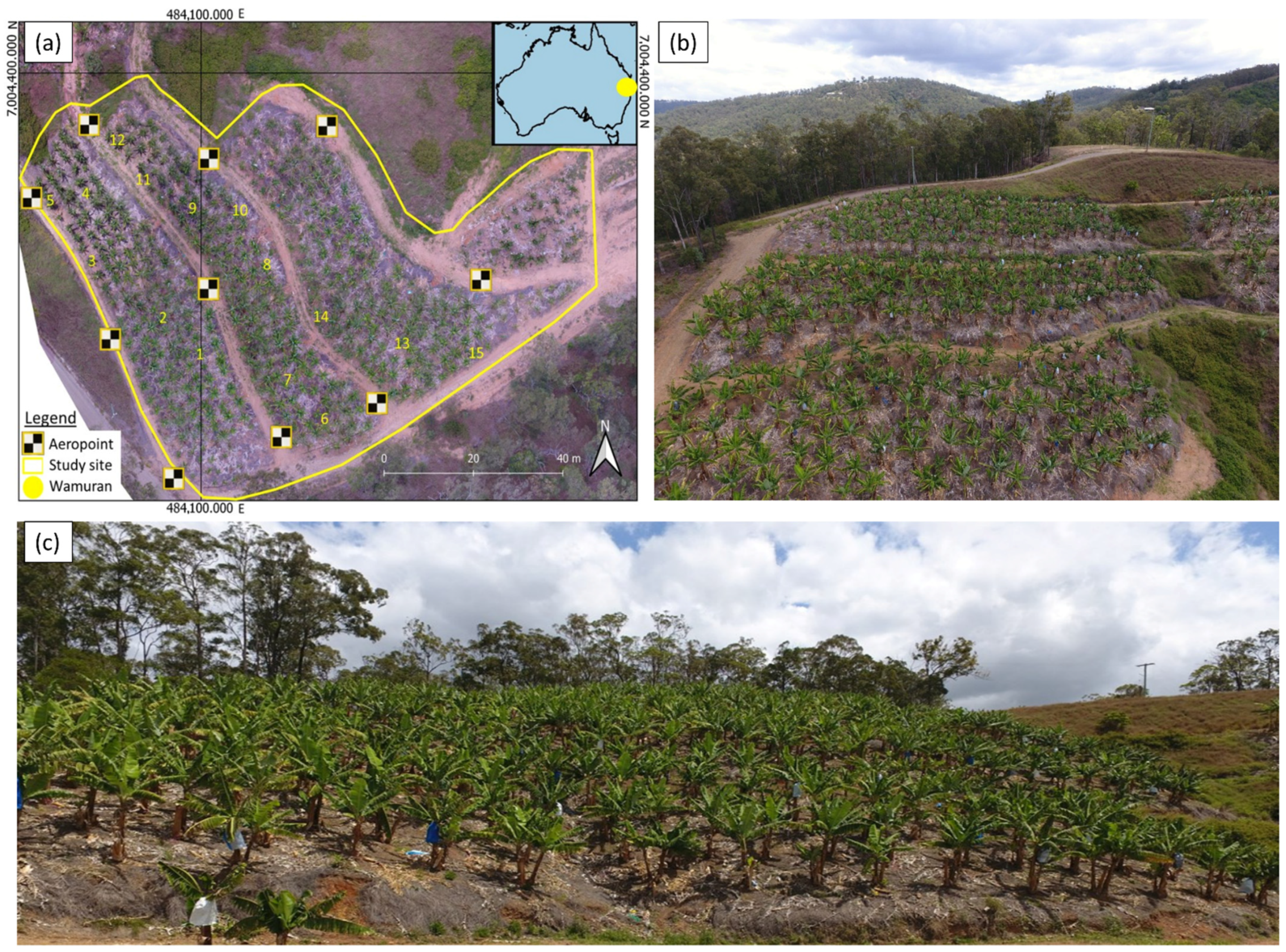
The study site for this investigation was a commercial banana farm located in Wamuran, Queensland, Australia (Figure 2), approximately 11 km west of Caboolture in South East Queensland. UAV data were acquired over an area of 0.5 ha located on a northerly aspect at 170 m above sea level falling to 113 m above sea level, with an average slope of approximately 21 degrees. Wamuran, situated in South East Queensland in the Moreton Bay region, possesses a humid subtropical climate with moderate-to-hot summer months (December to February) and cool-to-mild winters (June to August). Recordings from the Beerburrum weather station (#040284), located approximately 11 km west of Wamuran, show that temperatures during summer have a maximum average of 30.2 °C and winter average lows of 9.3 °C [48]. Rainfall primarily occurs in summer, with a maximum monthly summer average of 203.2 mm and a low of 45.9 mm in winter months. The surrounding region hosts forestry, farming (primarily strawberries and pineapple), and residential land use. This irrigated site cultivates approximately 600 Cavendish (Williams) banana plants spaced 2.5–3.0 m apart, with the general age of plants being over 6 years and new plantings established on an as-needed basis. High levels of asynchronous growth were present due to the age of the crop.

2.2. Field Data Collection and Ground Validation

Field measurements and growth observations were recorded over the course of the bunch cycle on 21 different dates for 15 selected plants (Figure 2). Prior to commencing the UAV flight campaign, the 15 plants were selected based on grower advice with the aim of covering the spatial variability of plant production occurring across the plantation (differences in yield, plant growth, and abiotic influence). Although the selection was kept as random as possible, plants were required to be near harvest and on safely accessible terrain. Growth observations of the 15 plants included the recording of key phenological events, such as flower emergence and harvesting, and count of the total number of functional (fully unfurled) leaves. To supplement observations, a photographic record of each of the 15 plants was made with photos taken from four cardinal directions using a Nikon Coolpix AW120 digital camera (Nikon Corporation, Tokyo, Japan).
To support field observations, the grower also provided information and scheduling of management activities (e.g., fertilization, pesticide, and meteorological events); deleafing, i.e., the management practice of removing the lowermost leaves; dates of flower emergence; and the final harvest weights of the majority of plants. Dates of key phenological events, including harvest of the mother plant and establishment of follower plant (H), flower emergence (E), and final harvest (H1), were identified based on the field and grower information and the initial closest capture date determined for the 15 plants (Figure 1).
Crown spread (horizontal width of the crown) measurements were made using a survey staff or a laser rangefinder as per the manufacturer’s recommendations (Laser Tech Inc, Centennial, CO, USA). Height was measured from the ground to the crown apex. The average crown spread measurements were calculated from 6 observations (Equation (1)) by averaging the horizontal distance measured in 6 different directions from the outermost leaf edge of the crown on one side to the outermost leaf edge on the opposite side (dripline) while intersecting the pseudostem, calculated as:
Average crown spread = 2 (SUM r/n)
where SUM is the aggregate, r is the radius measurement of the crown (psuedostem to edge of crown measurement), and n represents the number of measurements [49].
Measurements of leaf length and maximum lamina width were carried out on the field visit closest to observed flowering. From these measurements, total leaf area in m2 (TLA) (2) was calculated using the method described by Potdar and Pawar [50], and a leaf area factor of 0.83 was determined to be most suitable for Williams Cavendish [51]:
TLA = (l × w) × 0.83
where l is the measured leaf length and w is the measured maximum lamina width [50].

2.3. UAV Data Collection and Processing

Multispectral imagery was captured using a Parrot Sequoia camera (Parrot Drone SAS, Paris, France) mounted to a 3DR Solo quadcopter (3D Robotics, Berkeley, CA, USA). The Sequoia camera utilizes a 1280 × 960 pixel CMOS sensor that captures information in the green (530–570 nm), red (640–680 nm), red-edge (RE) (730–740 nm), and near-infrared (NIR) (770–810 nm) parts of the spectrum with an upward facing irradiance sensor for radiometric normalization purposes. UAV flight plans were programmed along flight lines forming a grid pattern following the direction of row plantings at a height of 50 m above ground level (AGL) with 80% sidelap, ~92% forward overlap (1 s capture interval), and 5 m/s flight speed using Mission Planner and the 3DR Tower App for flight control. These flight parameters produced an average pixel size of 4.28 cm. In an effort to maintain consistent altitude, flights were programmed perpendicular to the slope direction, with waypoints set at 50 m AGL based on a 1 m digital terrain model (DTM) obtained from the Queensland Spatial Catalogue [52].
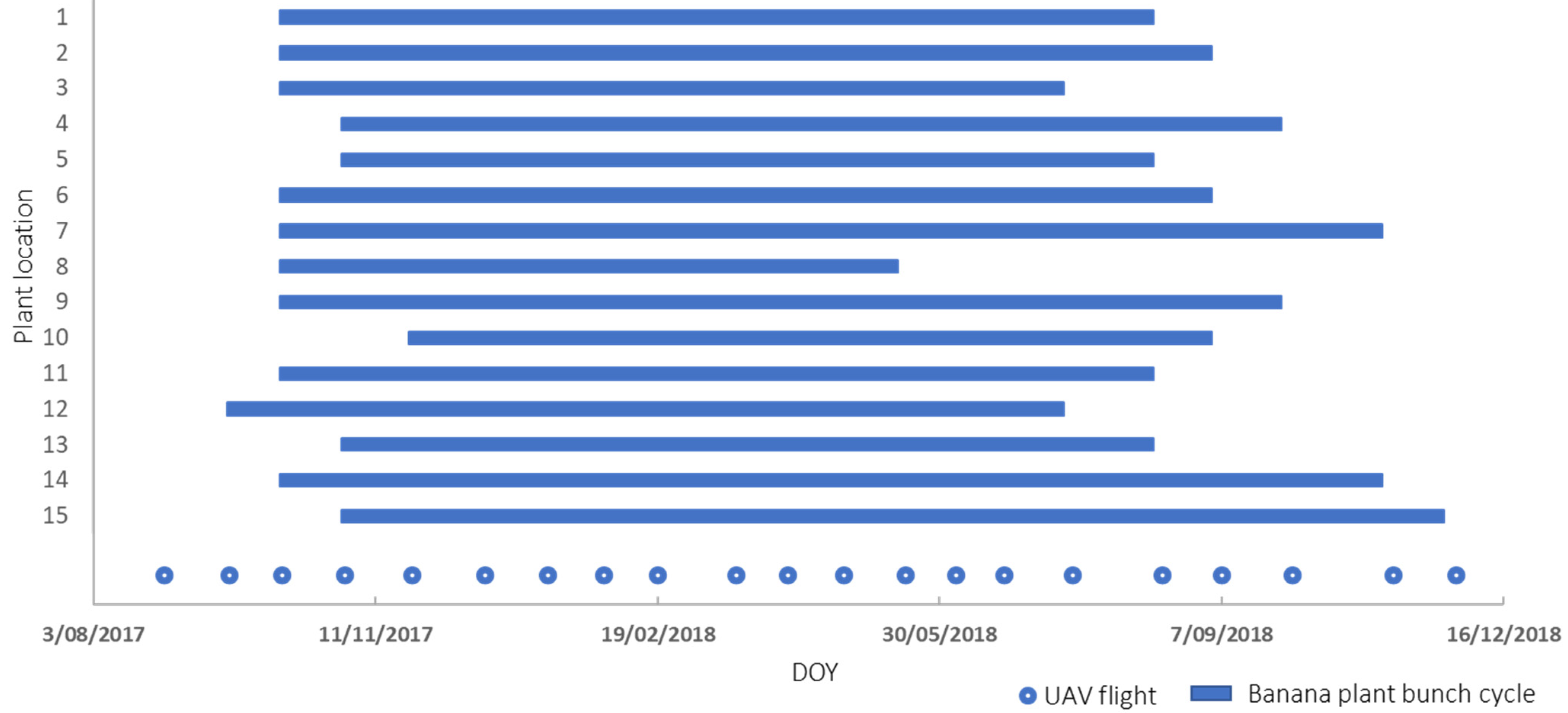
In total, 21 flight campaigns were conducted to capture data over the course of a bunch cycle of the 15 selected plants (locations depicted in Figure 2, and growth timeline illustrated in Figure 3). The majority of flights were undertaken under clear, cloud-free conditions, and for flights that occurred on days with limited cloud cover (<20%), image collection was timed during periods with no clouds obscuring the sunlight or casting shadows onto the study area. On days of high percentage cloud cover, captures were made under diffuse conditions with flights purposefully timed for data collection during homogenous illumination conditions. Although diffuse light conditions during flights are not considered ideal, Fawcett et al. [53] investigated the impact of captures made under homogenous diffuse conditions using a Parrot Sequoia sensor, reporting that diffuse condition captures were adequate for deriving phenological events with vegetation indices. Data from the irradiance sensor used to correct minor differences in illumination were not able to be applied for two flights (11 January 2018 and 2 October 2018) made under diffuse conditions due to sensor malfunction. However, as these flights were made under homogenous conditions, sensor performance was not significantly impacted [53]. On 31 January 2018, UAV mechanical failure resulted in partial capture of the 15 selected plants (90% complete) omitting Plants 13 and 15 from the series. Georeferencing of each collected UAV data set was based on 10 Propeller AeroPoint (Propeller Aerobotics Pty Ltd., Surry Hills, Australia). The position of the ground control points (GCPs) (Figure 1) was continuously recorded for at least 4.5 h for each UAV campaign with subsequent post-processing to improve the geometric accuracy using a Propeller network base station located 11 km from the study site.
Agisoft PhotoScan Pro (Agisoft LLC, St. Petersburg, Russia) was used to create othomosaics and digital surface models (DSM) from the multispectral data. Prior to image processing, photos were visually inspected and removed if they were captured during turns and height adjustment at the end of a flight line. For the photo alignment, the key and tie point limits were set to 40,000 and 10,000, respectively. GCPs were visually located in the images for georeferencing, and a dense point cloud was built using the high-quality setting and mild depth filtering to retain as much banana plant canopy detail as possible. The point cloud was then used to first produce a digital surface model (DSM) and a digital terrain model (DTM) by classifying ground objects in the point cloud. Prior to orthomosaic generation, the colour correction setting was enabled to account for Sequoia automatic capture settings (shutter speed and ISO values) and image vignetting. Images were converted to at-surface reflectance using an empirical line correction based on a MicaSense calibrated reflectance panel (RP series) captured prior to and post each flight [54,55]. The average ground sampling distance (GSD) of the orthomosaics was 4.3 cm. The orthomosaics were generated using the default mosaic blending mode and the DSM as the surface. A canopy height model (CHM) was created by subtracting the DTM from the DSM [55,56]. As previously experienced by [45], it was observed that the central parts of several banana plant crowns in the orthomosaics had a halo effect caused by the inability of the 3D reconstruction of the dense point cloud to identify the thin tips of the leaves, which, in turn, affected the DSM used as the surface for the orthomosaic generation [13,14]. To preserve the spectral information of the orthomosaics, the imagery was reprocessed using the DTM. While the use of the DTM for the orthomosaic generation solved the issue with the halo effect, it also meant that the banana plant crowns were not correctly orthorectified, causing slight geometric offsets, specifically of the taller parts of banana plants. However, in this study, preservation of the spectral information was considered more important than absolute geometric accuracy.
Orthomosaics based on the DTM were then used to generate commonly used vegetation indices (VIs) based on the available Parrot Sequoia bands, including the Normalised Difference Vegetation Index (NDVI)(3) [57], the Green–Red Vegetation Index (GRVI)(4) [58], the Enhanced Vegetation Index 2 (EVI2)(5) [39,59], and the Normalised Difference Red Edge Index (NDRE)(6) [60].
NDVI = (NIR + Red)/(NIR − Red),
GRVI = (Green − Red)/(Green + Red),
EVI2 = 2.5 × ((NIR − Red)/(NIR + 2.4Red + 1)),
NDRE = (NIR − RE)/(NIR + RE)

2.4. Individual Plant Crown Delineation, Height, and Crown Spread Estimation

The crowns of individual plants were delineated to calculate the mean of the VIs and derive morphological measurements of crown spread and height based on the CHM. Initial crown delineation was carried out within the geographic-object-based image analysis (GEOBIA) software, eCognition (Trimble, Munch, Germany). To delineate banana plant crowns, a threshold segmentation algorithm was applied using the CHM and thresholds of >1.5 m and <8.5 m. Additional threshold segmentation was carried out on candidate objects based on the EVI2 threshold values set determined by an automated threshold algorithm which uses a histogram-based method of pixel brightness to determine thresholds [61]. From the identified crown objects, individual crown delineation was carried out using a watershed segmentation algorithm based on the EVI2 layer and the 2D morphology pixel filter. Identified plant crowns were initially assigned a plant ID based on overlap, with a thematic layer of identified crown centres using the crown detection method developed in our previous work [45]. Crown objects were then exported to vector polygons (.shp file), and QGIS Geographical Information System (QGIS Development Team, http://www.qgis.org (accessed on 5 July 2021)) was used for further crown refinement, including omitting overlapping leaves as much as possible (as required) and to extract VI averages and maxima CHM values for each delineated crown for all dates using zonal statistics (Figure 4).
To determine if UAV data can provide a robust representation of plants over time, comparisons of estimated maximum height and crown spread based on the CHM and orthomosaic data were compared to field measurements. Crown spread was calculated from the minimum and maximum lengths obtained from a minimum oriented bounding box of each delineated crown. Crown height was derived from the CHM maximum value contained within each delineated crown [49]. A linear regression was calculated along with goodness of fit (R2) and root mean square error (RMSE) to assess the relationship between field- and UAV-derived measurements for the entire data set.

2.5. Phenological Changes (Time Series)

Investigation into plant canopy spectral change over the course of a bunch cycle was performed by constructing a time series of mean crown values of NDVI, a vegetation index commonly used in phenological investigations [9,53] and considered a relatively stable VI for the Parrot Sequoia under different illumination conditions [53,62]. In addition, morphological changes in crown spread and derived height were also made from delineated crowns. Similar to [63], the initial investigation involved the application of a second-order Savitzky–Golay filter (window size = 5) to reduce noise in the data for initial assessment [64]. An assessment was conducted to establish if the phenological methods commonly used in broadacre crops and forestry [10,11,65] for deriving key phenological markers, start of the season (SOS), peak, and end of the season (EOS) can be applied to banana crops. The vegetative stage onset at the time of mother plant harvesting is equivalent to SOS, with an accelerated rate of leaf emergence and progressively larger leaf size of the follower plant. The peak coincides with the visible reproductive stage of flower emergence, i.e., the time when the plant has the highest number of functional leaves, greatest height, stem girth, and crown size. From this point forward, no further leaves emerge and the crown condition worsens, with the remaining leaves often becoming damaged as the plant diverts its energy toward bunch-filling, culminating with harvest (EOS). For this study, the following terms are coined: harvest (H), representative of SOS; flower emergence (E), representative of peak; and harvest of follower plant (H1), representative of EOS (Figure 1). In addition, the derived flower initiation (I) date has been included for reference in the construction of time series curves.
Common methods of extracting phenological markers from NDVI were trialled, including double logistic curve-fitting and extraction of phenophases based on local extremes in the first derivative (curvature change rate) [9,65] as described by [66] and threshold-based derivation [10] based on spline interpolation of the time series data [10,11]. Lacking historic data, threshold derivation settings were iteratively set based on values able to provide alignment for the majority of plants. A seasonal amplitude of 35% was used to set timings for H and H1. Seasonal amplitude is the difference between the lowest or base NDVI value experienced near the start of season and end of season to that of the peak value. As illustrated in Figure 5, timings for H were set based on a 35% rise from the base NDVI level near the start of season (left minimum of the curve) relative to the peak NDVI amplitude value. Similarly, timings for H1 were based on a 35% rise from the right minimum of the curve relative to the peak amplitude of the curve. Prominence of peak and minimum separation masks were used to ensure true peak detection, which should coincide with flower emergence (E). Both of these masks work by disregarding small spikes in index values likely associated with vigorous growth during the plants’ vegetative stage as well as any spectral variance. The prominence of peak mask requires a threshold setting for how far the indices can fall as a percent on each side of a peak, and only once the series fulfils this threshold requirement is it considered the true peak. A 30% minimum prominence setting was used based on observations of spectral variance on either side of observed peaks. The minimum separation mask ignores all but the largest peak within the specified set time period and was set at 200 days, as only one bunch cycle could be achieved within this time period for the study crop. For morphological data, following spline interpolation, phenophase estimation from canopy spread, and height data were extracted based on the peak value and minimum extremes. Peak values of height/spread were used to represent E, the lowest height or spread value to the left of the curve was designated as H, and the lowest height/spread value to the right of the curve was designated as H1.

2.6. Yield Relationship to Vegetation Indices and Morphology

The relationship between the available field-measured plant yield (bunch weight) and vegetation indices and the morphology of individual plants was assessed using linear regression based on the coefficient of determination (R2), similarly to methods used by Robson et al. [67]. Selection of an appropriately set date to determine yield based on seasonal trends was not possible due to the asynchronous growth and lack of distinct seasonality. Therefore, the timing was determined based on the individual plant’s growth stage. The average VI values (NDVI, EVI2, GRVI, NDRE) of delineated plant canopies, as well as crown height, crown spread, and TLA, were compared at the closest capture date to flower initiation and again at flower emergence. Flower initiation was inferred based on flower emergence occurring after the appearance of 11–12 full leaves [5,68]. Plant health and crown size at flower initiation and emergence are considered to influence final bunch weight. The initiation period influences the number of fruit set on the inflorescence prior to emergence, whereas plant health and crown size at flower emergence influence the ability to fill fruit and, consequently, fruit size [5].

3. Results

3.1. Banana Plant Morphology Estimation

A comparison of maximum CHM heights for each crown compared to field-based height measurements was made for each sample date. UAV-derived canopy heights were positively correlated with the field measurements producing an R2 value of 0.77, an RMSE of 0.61 m, and an average overestimation of plant heights from the CHM, with a UAV-derived average of 3.75 m and a field-based average of 3.53 m based on 260 observations (Figure 6a). Seven outliers were identified and excluded from the analysis due to overlapping crowns from adjacent plants (four plants excluded); inaccurate 3D reconstruction of smaller plants due to occlusion from surrounding larger plants (two plants excluded); and one case, likely due to crown sparsity as a result of disease damage. Potential variations in height may be caused by the crowns’ non-rigid structure and lack of distinct apex for both field and UAV-derived measurements. Additionally, leaf emergence can change the height of the crown as leaves emerge from the centre of the crown in a vertical position before unfurling, at which time they assume a horizontal position.
Comparisons of canopy spread based on field measurements to that of orthomosaic-delineated crowns provided a positive correlation with an R2 value of 0.69 and an RMSE of 0.47 m. Canopy spread based on the UAV data was underestimated, with a mean of 2.66 m for UAV-derived data as opposed to 2.85 m for field-derived data from 274 observations (Figure 6b). Improved results may be realized with improvements in 3D reconstruction before orthomosaic generation. The GEOBIA ruleset devised for crown delineation reduced processing time and minimized manual editing, which was mainly required for adjacent crown overlap and when follower crowns became larger (in the latter half of the growth period) causing canopy volume to increase. However, ruleset improvements and greater resolution or additional data sources could reduce manual editing and error associated with delineation.

3.2. Banana Plant Phenology Estimation

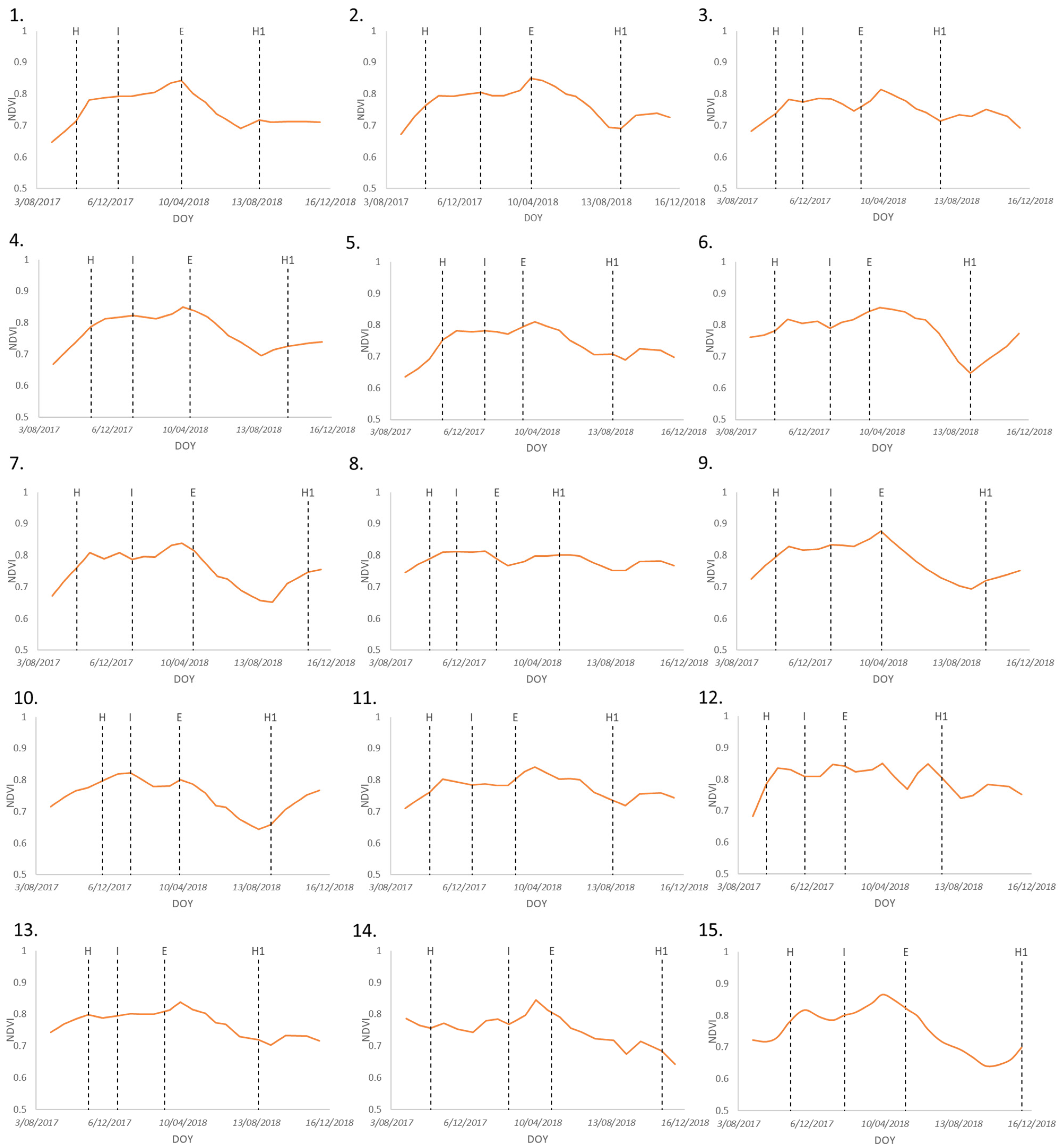
Prior to extraction of key phenological marker dates (H, E, H1), a time series of extracted crown mean values for NDVI (Figure 7) revealed that VI peaks generally coincide with field-observed flower emergence, except for Plants 8, 12, and 15. As banana bunches develop and become heavier, plants tend to tilt slightly, an effect that worsens over time, which may cause different spectral responses due to changed leaf orientation. All plants were located on a slope, with Plants 8 and 12 being on a greater incline, which caused increased tilting. The growth of Plant 8 was faster than all other plants (Figure 3), with vigorous growth from both the study plant and subsequent follower plant. At harvest, both the mother crown and follower plant crown were of similar heights and intermingled. Plant tilt and the early follower selection (by the farmer) caused advanced follower plant growth relative to other followers and are likely to have exacerbated the height similarity between crowns due to followers being almost the same height and size of mother crowns at an earlier stage, causing crown overlap. The tilt of Plant 12 caused the crown to overlap above adjacent plants. That, combined with more undergrowth due to its location at the fringe of the field near ground cover, may have provided changes to the spectral response, particularly following rain. Follower crown overlap observed in Plant 3 is likely the cause of a delay in VI peak.
From the time series of height and spread (Figure 8), the expected trend of plants with the maximum height/spread can be observed at or around the time of flowering. Similarly, plants with the minimum height and the minimum canopy spread also provide a good indication of H and H1. Because of the use of morphology for phenology estimation, structure variations possibly caused by factors discussed in the previous section (Banana plant morphology) also apply, i.e., crown size can be influenced by delineation accuracies (e.g., overlapping crown) and crown condition (e.g., disease). Height variation may be caused by the crowns’ non-rigid structure, lack of distinct apex, and leaf emergence status.
Biotic and abiotic conditions that may have caused changes to the spectral response and influenced plant morphology included rainfall and storm events; disease; and management practices such as fertilization, desuckering, and deleafing. A storm event just before 31 October 2017 and rainfall on 11 January 2018 caused waterlogging and standing water to be present during captures on these dates. Areas that were particularly affected by these events were plants nearest roadways and in gully areas, including Plants 3, 5, and 11–14, and the October event would likely help drive rapid vegetative growth. Rain fell prior to the 6 April 2018, storms occurred the week prior to 16 July 2018, and crop irrigation was applied prior to 29 November 2018. Rainfall events are reasoned to cause a delayed flux in VIs caused by plant use after ground infiltration and plant uptake in addition to the increases in plant vigour [37] and increases in the undergrowth, which were noted for Plants 8, 10, and 12. Increases in soil moisture and reduced solar radiation (cloud cover) are also thought to expose a greater leaf area due to reduced levels of diurnal leaf folding [35].
A wet soil background can also cause changes in VI values [69]. All plants suffered shredded leaves, particularly as a result of storms, with the study plants located at higher elevations in the southwestern portion of the study site (Plants 1–5) having greater exposure to wind and storm events.
Fertiliser was applied in the weeks before 24 November 2017, 19 February 2018, 18 May 2018, and 29 November 2018, and weed-control spray was applied the week after 31 October 2017 and 6 April 2018. Leaf spot was also noted from 6 April 2018, affecting the lower portion of the paddock in the northeast and gradually progressing up the slope, with sustained deleafing occurring during this period. A generalisation is that fertiliser improves plant health and vigour and causes increases in NDVI whereas leaf spot, de-leafing, and leaf shredding are likely to cause a reduction, although further study is required to quantify these impacts.
A comparison of the methods for deriving phenophases (Figure 9) found that morphological attributes of canopy height and canopy spread provided greater success and more consistency in predicting H and H1 across all plants, with height providing greater accuracy overall. Crown spread provided a similar prediction result for H to that of canopy height. However, crown spread was less consistent in its ability to detect H1, with several predictions having large biases (Plants 3, 8, 14, 15). Modelling bias in Plant 8 is considered to be caused by poor separation of mother and follower crowns during delineation and the follower having a similar crown spread to that of the mother plant at harvest. For Plants 14 and 15, the onset of disease is the likely cause for a reduction in crown size due to aggressive deleafing management. Changes to the plants’ morphologies as a result of factors such as deleafing caused a deviation in crown spread and had less impact on height. Height was found to have greater consistency despite having a slight overall bias in H1 predictions, which was possibly a function of interpolation creating a lag response on harvest dates. Height may have had better performance as it was less impacted by factors such as poor delineation and loss of understory leaves compared to crown spread.
The success of the logistic function fit was dependent on plants having a smooth well-defined growth curve. Four plants had a poor fit (Plants 6, 11, 14, 15) likely due to a sharp increase in growth at the beginning of the vegetative growth stage, or lack of distinct peak and greater VI amplitude decrease after flowering. As a result, the use of the curvature change rate (CCR) to extract accurate phenophases was poor. Derived results of H on these poorly fitted plants were located outside the growth range dates or close to flowering (E) dates, providing an unrealistic growth period. A lack of amplitude increase caused delayed prediction of H and a large bias in Plants 6 and 14 using the threshold method. Following the omission of outliers (Figure 9) for both the CCR and threshold methods, the threshold method provided a better prediction result for H, and both had similar results for H1, with neither providing superior results to the morphology-based methods for the detection of H and H1. Both CCR- and threshold-based phenophase dates for H1 provided poor estimation compared to morphological attributes, with almost all dates being early compared to field-derived dates. Greater amplitude changes in growth between E to H1 compared to H to E were likely impacted by the onset of disease, particularly in plants in the northwestern portion of the field. The delineation and inclusion of follower crowns immediately after harvest reduced detection rates of H and H1 events, i.e., from mother crown straight to follower crown at harvest. If an immediate switch from the mother plant to the follower plant did not occur and detection was a stationary area of interest, intermediate detection of undergrowth and bare soil left in the absence of the mother plant at the harvest stage would provide a clearer indication of harvest. Building in some form of logic during crown detection to alert significant movement of crown and/or size reduction could be used to better detect H and H1 events and also provide superior curve fit.
The most successful indicator of E was derived using the VI threshold method, providing a more consistent result with the least amount of average bias (6 days) compared to CCR (15 days) and the morphological-based methods of height (23 days) and spread (11 days). However, the function of detection is not necessarily based on a set threshold but rather on maximum values from the interpolated spline. Plant 10, considered an outlier, showed significant bias in the threshold method, with derived flower emergence occurring 90 days earlier than the field observations. This inaccuracy was found to be caused by crown overlap, with adjacent plants likely increasing the VI and height. Although efforts were made during crown delineation to omit crown overlap, not all occurrences could be removed. Canopy spread provided the next-best result, with a greater bias spread partially associated with outlier Plants 12 and 13 flower emergence occurring later than in field observations. Dissimilarities in emergence for Plant 12 are likely caused by tilt and undergrowth (discussed earlier), and those in Plant 13 are caused by inaccuracies in delineation. Height provided an inaccurate result, with the largest range spread in bias and predictions up to 109 days prior to field observations of emergence. It was noted that in many cases, once near-maximum height was reached, there were often only small variations in height. A spike in height for Plants 6 (in July 2018) and 7 (in December 2017) was caused by overlapping leaves from an adjacent taller plant. Greater control over the removal of overlapping leaves was generally possible during the extraction of VI means. However, the CHM was not detailed enough to omit these areas.
When comparing the most accurate detection methods in real terms, H and H1 detection based on the CHM were either detected on “harvest” days or UAV flight dates on either side of harvest, often with minimum height differences (<0.5 m) between captures. Therefore, accurate representation and detection relate to improvements in capture and reconstruction as discussed in Section 3.1. The bias in threshold detection for flower emergence ranged from 2 to 90 days, with an average bias of 24 days recorded.

3.3. Yield Relationships to Vegetation Indices and Morphology

A strong correlation was found between VIs and banana yield at the time of flower emergence. The highest R2 of the bunch weight at harvest was achieved using EVI2 (R2 = 0.77) followed by NDVI (R2 = 0.71) (Figure 10). When comparing plant morphology to yield at flowering, a strong positive relationship could be found for yield and total leaf area (R2 = 0.72). However, only a moderate relationship was achieved for yield based on crown spread (R2 = 0.51), while a very weak positive relationship occurred between yield and height (R2 = 0.02). Considering the strong positive relationship between yield and total leaf area, it was initially thought that height may provide a good indicator of yield based on pseudostem formation, with increases in leaf production driven by height and, in turn, provision of greater leaf area. However, in this case, height was a poor indicator of total leaf area (R2 = 0.16), whereas crown spread provided a better indicator of total leaf area (R2 = 0.80). Deleafing is considered to be the cause of the poor relationship between height and total leaf area, as height is not able to measure the loss of understory leaves, whereas the manner in which crown spread is measured provides an indication of changes to the size of the leaf perimeter and can be related to total leaf area.
In remote sensing, VIs can be often used as a proxy for plant health, with healthier, more vigorous plants having greater yield, as demonstrated by Robson et al. [67], who found a positive relationship between plant vigour, (health, leaf density, and crown size) and yield of avocado and macadamia trees. A similar relationship for banana plants is plausible during flowering, when plants are considered to be at the peak of vegetative growth and are diverting energy toward fruit filling [4]. The relationship between VIs and yield at the time of inferred flower initiation did not provide as strong a relationship, with the highest regression coefficients being reported for NDRE (R2 = 0.56) and NDVI (R2 = 0.53).

4. Discussion

4.1. Individual Crown Delineation and Morphology Estimates

UAV-derived data provided spectral and spatiotemporal appropriate data to enable the tracking of the transitions in the growth of banana plants throughout the season at the individual crown level. Morphologically derived data from the orthomosaics and CHM were able to show changes in plant height and canopy size over time, representing the expected curvature in the growth pattern of plants from initial establishment, with the increase in height and canopy to peak height and crown spread at flower emergence followed by harvest denoted by a reduction in height and canopy size. In general, spectral data were found to be effective in the tracking of plant growth, although potentially prone to biotic and abiotic effects encountered during the study. Sensor radiometric stability for UAV multitemporal analysis also needs to be considered to provide a realistic expectation of reliability and application suitability. The combination of all data streams provided an informative picture of the status of individual plants, and although precise detection of specific days for flower emergence may not always be accurate, the information does provide a good indication of the general occurrence of phenological events.
Validation of the UAV-derived crown spread and height data against field measurements was important for this study. Similar to Aeberli et al. [45], the overall average crown heights were slightly overestimated by the UAV-derived CHM. However, height was underestimated in taller plants (>4 m). In comparison, UAV-derived height was underestimated in other tree crops, such as avocado [14,17], lychee [18], and olive trees [13]. When comparing correlation results (R2 0.77) to other studies, the R2 values are lower than those reported by [8] (R2 = 0.9) at a similar GSD, similar to mango trees at a similar flight height (R2 = 0.81) [17] and slightly better than those for lychee trees (R2 = 0.60) using the same flight height and UAV equipment [18]. Differences in flight-planning choices—such as flight altitude, speed, flight pattern, and shutter speed—as well as processing workflows can introduce inaccuracies into 3D reconstruction [14,17]. However, differences in structure and leaf arrangement of these tree crops compared to banana plants are likely to contribute to the differences in results. A smaller GSD resulting from a lower flight altitude would contribute to a better result in canopy height estimation [13,18]. However, due to the surrounding vegetation, a lower flight altitude could not be used. Improvements to the CHM modelling could also be realized through the use of higher-resolution sensors or LiDAR data [18].
Image registration using GCPs (AeroPoints) provided a high geometric accuracy (RMSE = 0.05 m) similar to other studies [14,18]. Despite high geolocational accuracy aiding in identifying the location of individual plants, the delineated crown location varied between dates due to the mobile structure, influenced primarily by phenology but also terrain (plant tilt), wind effects at the time of data collection, and changes in crown size. This dictates a need for detection and delineation of individual crowns for each time series date. Semiautomated delineation of plant crowns contributed to a faster workflow, although improvements and further exploration of methods are needed for widescale adoption to account for high levels of crown overlap and possibly vigorous undergrowth, which can cause variations in the reflectance data. Investigations into individual banana crown delineation by Kuikel et al. [70] provided 98.6% accuracy based on convolutional neural network classification. However, it is uncertain regarding the presence of crown overlap and methods applied to address crown overlap. Kestur et al. [43] used watershed and region growing approaches to account for limited crown overlap, but the level of overlap appeared minimal. In our study, additional effort was made during the manual delineation process of individual crowns to omit overlapping portions of crowns. Despite efforts, overlapping crowns were difficult to omit and differentiate from one another and are considered a potential cause for misrepresenting VI and/or CHM measurements for affected plants (e.g., Plants 6 and 7) or over several dates (most notably Plants 3, 10, 12). Overlapping crowns were particularly a problem for CHM extraction as the same level of refinement was not possible due to the inability to visually separate plants and reconstruction artifacts. Extraction based only on the centre portion of crowns may provide a better result for CHM, assuming consistent alignment of layers. Tree crown delineation methods used to determine and account for the amount of crown overlap that may be relevant to banana plants include utilising growth information from adjacent plants or fusion of LiDAR sensor information [71]. Additional factors that have the potential to influence spectral measurements is the understory and difficulty in the delineation of the follower plant crown, such as that encountered for Plant 8, with follower selection and growth having the potential to impact upon derived crown VI information.
Based on the delineated crowns, the results of crown spread were underestimated compared to field-based measurements for this study (R2 0.69 RMSE 0.46). When comparing the same crown estimates to our previous study, a reduction in performance could be observed with a similar mean difference (R2 of 0.85 and RMSE 0.45) [45]. Reductions in the ability to estimate crown spread may be related to a comparison over a greater variance in canopy size due to a larger sample size and over a longer period of time. Differences in measurement methods, canopy morphology, crop layout, and management practices (such as mechanically pruned hedgerows) make a comparison to other tree crops difficult. Reported measurements of crown width based on the widest axis of the crown in lychee crops by [18] provided highly accurate results based on the same flight height and equipment with an R2 = 0.93 and RMSE of 0.63 m, finding that estimates in width were near identical based on flight heights between 30–70 m. Dissimilarities may have been introduced based on the difference in the in-field methods used to measure individual crown size and the ruleset algorithm combinations used in the GEOBIA-based delineation methods.
The ability to accurately delineate crowns based on the GEOBIA methods developed may provide avenues for further study. Although it was observed that banana crown shape can be highly variable over a growth cycle, extracted crown patterns may help with observations of changes in plant growth. Examples of other useful monitoring applications related to crown structure include monitoring of plant damage or disease, indirect assessment of soil moisture based on canopy change [35], and delivery of information on planting, deleafing, and desuckering to optimise light interception in a manner similar to pruning of tree crops [14,18].

4.2. Phenological Changes (Time Series)

At this stage, there is currently no consistent method of predicting the flower emergence of banana plants. Flower initiation is internal, making the prediction of emergence difficult, and although factors may influence timing, no direct, reliable linkage has been proven, with research reasoning a combination of factors may influence flower initiation, including photoperiod, temperature, seasonal trends, and water and nutrient availability [5,72]. Therefore, monitoring growth trends in a manner used for this study may provide important information for scheduling treatments and management.
Banana plants’ unique determinate vegetative growth cycle of the vegetative phase, flower emergence, bunch production, and senescence (or harvest) allows for the monitoring of identified growth stages similar to seasonal crops or deciduous forests [10,53,73]. The majority of methods reviewed rely on VIs (often NDVI) for growth stage status, with some examples of crops utilizing SfM- or LiDAR-derived height for growth height assessment [74]. Banana plants provide an opportunity to utilize both metrics as well as crown spread to determine growth status with each method providing valuable information.
The trialled methods of extracting phenological markers had mixed results, with direct measurements based on minima from the CHM providing a good indication of beginning and end of season harvest. Although peaks in NDVI provided the best result for flower emergence, additional testing is required to determine seasonal trends and substantiate these findings with a greater variety of plants of differing ages to enable broader application potential. Unlike threshold methods, change of rate derivate-based methods are attractive as they require no prior knowledge of crops and little input to set. Curve fitting based on [9] was utilized for this study, however, trials of different logistic and derivative functions may provide a more accurate result [65].
For UAV-based sensors, potential errors can be introduced during image capture and processing. The Parrot Sequoia sensor has been the subject of several studies [53,55,62,75,76,77] and overall is considered to provide valuable spectral information, albeit with some caveats or flaws. By design, sensor bands are aligned to provide greater radiometric stability when using band ratios such as NDVI [62], and illumination is not considered to significantly impact reflectance across all bands, particularly RE and NIR on measurements of calibration panels [77]. However, it is important to consider weaknesses in sensor characteristics before application, e.g., radiometric calibration of visible (red and green) bands may not be calibrated as effectively and may be more sensitive to calibration error due to saturation at around 30–45% reflectance leading to saturation under bright capture conditions and inaccuracies in digital number to reflectance transformation [62,77].
Under differing light conditions, Fawcett et al. [53] observed slight fluctuations in NDVI but considered data fit for monitoring phenological trends (spring green-up). However they found it less suitable for monitoring changes in evergreen trees due to only subtle differences in NDVI across the season. Encouragingly, tests of sensor performance over banana plant canopies were found to be more consistent over different captures compared to other tree crops, likely due to the simple crown and leaf makeup of banana plants [55]. NDVI was chosen to showcase this proof-of-concept study based on a well-established VI for assessing phenology [53,63,78]. Trials of additional VI’s may provide greater sensitivity to phenological change as discovered for EVI in temperate forests [79] or measurements of crop productivity using NIRv [80]. Machine learning applications could also provide additional accuracies but necessitate a sufficiently large scale study to provide accurate model creation [81]. In addition to seasonal growth and radiation changes, considerations that may warrant further studies in banana crops include the effects of shredded leaves, diurnal leaf folding in relation to water deficit [35], minimization of photochemical damage [32], and terrain encountered at the study site causing change in leaf orientation.
Basing phenology detection on VIs presents the risk of biotic and abiotic factors causing perturbations and poorly derived phenology [67]. UAV sensor performance also must be considered. Therefore, morphological attributes may provide a better indication of growth status. The use of a CHM provides a far less labour- and computer-intensive method for deriving information on plant growth and is a product generated when constructing the orthomosaic, which requires minimal further processing for extraction, whereas crown spread requires extra steps of delineation. Improvements to CHM generation to more accurately represent field heights may provide a good method of phenology detection, as representation of height variation in the CHM was subtle and height tended to stabilize near flowering events. In addition, there is no need for a specialized multispectral camera, and automated detection and extraction could be based on the central tallest portion of the plant, which is less prone to crown overlap using methods of detection proposed in previous studies [45]. Finally, increased flight cadence, with more frequent visitation could provide more reliable data streams that are less affected by perturbations leading to improved prediction capacity of farm-based monitoring. The ability to phenotype plants and quantify phenological events is not only useful for monitoring purposes but also allows further development of crop modelling not only for production [2] but also for response to biotic and abiotic occurrences.

4.3. Yield Relationship to Vegetation Indices and Morphology

From our study, a positive relationship could be established between VIs and yield in banana plants. Despite differing approaches, previous studies have also supported a positive relationship between remotely sensed NDVI and banana crop health or yield. Machovina et al. [82] used data gathered from three flights of a fixed-wing UAV (10 cm resolution) to establish a positive relationship between bunch weight based on 76 weeks of production records and NDVI averages of field locations based on 10 m zones. A more recent study used several captures of high-resolution WorldView-3 satellite imagery to form a composite NDVI map to overcome the asynchronous growth of banana plants within the crop. From this data, lower-performing areas of crops were identified for potential targeted management, but individual plant productivity was not able to be provided due to inadequate spatial resolution (120 cm) [38]. Our study further supports the utility of remote sensing and the use of VIs in banana crops and extends existing work by providing targeted plant yield estimates rather than broader crop zones and averages of health or yield.
Nyombi et al. [4] reported a positive relationship between pseudostem girth at flowering and bunch weight and in the same study established a relationship between pseudostem girth, total leaf area, and plant height (R2 = 0.67). Although no direct linkage was explored, it could be reasoned that total leaf area, height, and bunch weight share a similar relationship. The findings of our study support a relationship between bunch weight and total leaf area. However, a relationship with height was not found, possibly due to deleafing.
Although bunch weight is important in determining productivity, banana plant phenology also must be considered, with the onset and duration of the bunch production cycle being important. As discussed by Lamour et al. [2], the ability to determine the cadence of flowering is important to consider when determining the yield performance of a banana crop. Indicating flower emergence and production length through the use of remote sensing provides the potential for targeted treatment and management to boost production. For example, to improve productivity and ease management in the subject study farm, aging plants were replaced with new plantings to provide a more vigorous production cycle through the faster growth in younger plants and to reduce asynchronous growth between plants.
The use of VIs provides a potential approach for determining yield, and so too does the use of crown spread. This study provides novel information and potential methods for determining yield (in addition to an application for morphology and phenology monitoring). However, further validation is warranted to strengthen relationships and determine if the findings are crop-specific. For example, morphological traits are not likely to be generalized between bioregions and varieties, with different environmental factors and allometric relationships coming into play. Such a finding was highlighted when varietal and environmental differences provided disparate allometric relationships in banana plants [4]. The framework of methods used in this study can guide and easily be adapted to different farms to establish crop-specific benchmarks and tailored information suitable for management.
More recent advances in UAV sensors on the market, such as more advanced multispectral cameras with alternate band selection and a greater number of bands (e.g., MicaSense Altum) or hyperspectral sensors, have the potential to provide greater accuracy for monitoring phenology and yield estimation. The additional data captured can also add value through the potential for monitoring other aspects such as pest and disease based on the greater sensitivity that these sensors can offer. The use of different UAV sensors has potential for future studies but requires balancing of financial outlay, user knowledge, and additional processing requirements to determine if they are fit for use in the banana industry.

5. Conclusions

Our research provides important insight into individual banana plant phenotypic traits derived from UAV-based data. Owing to the unique growth characteristics of banana plants over a production cycle, the ability to derive spectral data related to biomass, health, and morphological attributes provides valuable information for aiding management decisions. Investigation into the potential for deriving individual banana plant phenological status, and yield provides further advantages for monitoring plant performance and crop modelling.
Building on our previous investigation into crown detection methods [45], this study presented a GEOBIA-based workflow for delineating individual banana canopies. The use of multispectral UAV orthomosaics and CHM provided a suitable method for the estimation of crown morphology (height and spread). In addition, estimates of plant establishment and harvest are able to estimate dates of plant establishment and harvest with proximate dates of flowering also able to be extracted. Finally, a preliminary investigation found spectral indices provided a good predictor of yield using data captured around the time of flower emergence. Improvements in the CHM could provide a more straightforward basis for growth detection. A combination of all data sources may provide valuable information on plant dynamics and the potential to be used for management decisions. The ability to determine the occurrence of flowering and derive yield as well as the cadence of flowering provides a valuable aid for the management and production of bananas.
Crown overlap from adjacent plants and influence from the follower plant represents a potential problem for deriving accurate metrics of growth for individual plants. Therefore, additional research into a crown delineation method that can account for crown overlap is important. Improvements to phenological monitoring could be realised by exploring the use of different models, sensors, VI’s [80] and machine learning methods [81], particularly at a larger scale. In addition, further research into profiling biotic and abiotic influences on banana crowns’ spectral response and validating the findings of this study based on whole crops and in different bioregions would provide valuable steps toward the development of crop monitoring and production tools.

Author Contributions

Conceptualization, all the authors.; methodology, A.A., S.P., K.J. and A.R.; software, A.A.; validation, A.A.; formal analysis, A.A.; investigation, A.A.; resources, all authors; data curation, A.A.; writing—original draft preparation, A.A.; writing—review and editing, all authors.; visualization, A.A.; supervision, all authors.; project administration, S.P. and A.R.; funding acquisition, A.R. and S.P. All authors have read and agreed to the published version of the manuscript.

Funding

This research was funded by Horticulture Innovation and the Department of Agriculture and Water Resources, Australian Government as part of its Rural R&D for Profit Program’s subproject “Multi-Scale Monitoring Tools for Managing Australia Tree Crops-Industry Meets Innovation” (grant RnD4Profit 14-01-008).

Data Availability Statement

The data presented in this study is available on request from the corresponding author and will only be supplied following permission from the farm holder due to privacy considerations.

Acknowledgments

The authors would like to acknowledge the support from Earle Lawrence (farm holder); Barry Sullivan (Australian Banana Growers Council); fieldwork assistance from Yu-Hsuan Tu and Dan Wu.; scripting support and advice from Yu-Hsuan Tu and Derek Schnieder; D.W.L. acknowledges the support of Food Agility CRC Ltd., funded under the Commonwealth Government CRC Program. The CRC Program supports industry-led collaborations between industry, researchers, and the community.

Conflicts of Interest

The authors declare no conflict of interest.

References

  1. Brinkhoff, J.; Robson, A.J. Block-level macadamia yield forecasting using spatio-temporal datasets. Agric. For. Meteorol. 2021, 303, 108369. [Google Scholar] [CrossRef]
  2. Lamour, J.; Le Moguédec, G.; Naud, O.; Lechaudel, M.; Taylor, J.; Tisseyre, B. Evaluating the drivers of banana flowering cycle duration using a stochastic model and on farm production data. Precis. Agric. 2020, 22, 873–896. [Google Scholar] [CrossRef]
  3. Lindsay, S.; Campagnolo, D.; Daniells, J.; Lemin, C.; Goebel, R.; Pinese, B.; Peterson, R.; Evanas, D.; Pattison, T. Tropical Banana Information Kit; Department of Primary Industries, Queensland Horticulture Institute: Brisbane, QLD, Australia, 1998. [Google Scholar]
  4. Nyombi, K.; Van Asten, P.J.A.; Leffelaar, P.A.; Corbeels, M.; Kaizzi, C.K.; Giller, K.E. Allometric growth relationships of East Africa highland bananas (Musa AAA-EAHB) cv. Kisansa and Mbwazirume. Ann. Appl. Biol. 2009, 155, 403–418. [Google Scholar] [CrossRef]
  5. Robinson, J.C.; Saúco, V.G. Bananas and Plantains; Cabi: Wallingford, UK, 2010; Volume 19. [Google Scholar]
  6. Turner, D.W.; Fortescue, J.A.; Thomas, D.S. Environmental physiology of the bananas (Musa spp.). Braz. J. Plant Physiol. 2007, 19, 463–484. [Google Scholar] [CrossRef]
  7. Barker, W.G. Growth and Development of the Banana Plant Gross Leaf Emergence. Ann. Bot. 1969, 33, 523–535. [Google Scholar] [CrossRef]
  8. Gomez Selvaraj, M.; Vergara, A.; Montenegro, F.; Alonso Ruiz, H.; Safari, N.; Raymaekers, D.; Ocimati, W.; Ntamwira, J.; Tits, L.; Omondi, A.B.; et al. Detection of banana plants and their major diseases through aerial images and machine learning methods: A case study in DR Congo and Republic of Benin. ISPRS J. Photogramm. Remote Sens. 2020, 169, 110–124. [Google Scholar] [CrossRef]
  9. Zhang, X.; Friedl, M.A.; Schaaf, C.B.; Strahler, A.H.; Hodges, J.C.F.; Gao, F.; Reed, B.C.; Huete, A. Monitoring vegetation phenology using MODIS. Remote Sens. Environ. 2003, 84, 471–475. [Google Scholar] [CrossRef]
  10. Belda, S.; Pipia, L.; Morcillo-Pallarés, P.; Rivera-Caicedo, J.P.; Amin, E.; De Grave, C.; Verrelst, J. DATimeS: A machine learning time series GUI toolbox for gap-filling and vegetation phenology trends detection. Environ. Model. Softw. 2020, 127, 104666. [Google Scholar] [CrossRef]
  11. Jönsson, P.; Eklundh, L. TIMESAT—A program for analyzing time-series of satellite sensor data. Comput. Geosci. 2004, 30, 833–845. [Google Scholar] [CrossRef] [Green Version]
  12. Maes, W.H.; Steppe, K. Perspectives for remote sensing with unmanned aerial vehicles in precision agriculture. Trends Plant Sci. 2019, 24, 152–164. [Google Scholar] [CrossRef]
  13. Torres-Sánchez, J.; López-Granados, F.; Serrano, N.; Arquero, O.; Peña, J.M. High-throughput 3-D monitoring of agricultural-tree plantations with unmanned aerial vehicle (UAV) technology. PLoS ONE 2015, 10, e0130479. [Google Scholar] [CrossRef] [PubMed] [Green Version]
  14. Tu, Y.-H.; Johansen, K.; Phinn, S.; Robson, A. Measuring Canopy Structure and Condition Using Multi-Spectral UAS Imagery in a Horticultural Environment. Remote Sens. 2019, 11, 269. [Google Scholar] [CrossRef] [Green Version]
  15. Wu, D.; Johansen, K.; Phinn, S.; Robson, A. Suitability of airborne and terrestrial laser scanning for mapping tree crop structural metrics for improved orchard management. Remote Sens. 2020, 12, 1647. [Google Scholar] [CrossRef]
  16. Watts, A.C.; Ambrosia, V.G.; Hinkley, E.A. Unmanned Aircraft Systems in Remote Sensing and Scientific Research: Classification and Considerations of Use. Remote Sens. 2012, 4, 1671. [Google Scholar] [CrossRef] [Green Version]
  17. Wu, D.; Johansen, K.; Phinn, S.; Robson, A.; Tu, Y.-H. Inter-comparison of remote sensing platforms for height estimation of mango and avocado tree crowns. Int. J. Appl. Earth Obs. Geoinf. 2020, 89, 102091. [Google Scholar] [CrossRef]
  18. Johansen, K.; Raharjo, T.; McCabe, M.F. Using Multi-Spectral UAV Imagery to Extract Tree Crop Structural Properties and Assess Pruning Effects. Remote Sens. 2018, 10, 854. [Google Scholar] [CrossRef] [Green Version]
  19. Sims, D.A.; Gamon, J.A. Relationships between leaf pigment content and spectral reflectance across a wide range of species, leaf structures and developmental stages. Remote Sens. Environ. 2002, 81, 337–354. [Google Scholar] [CrossRef]
  20. Bolton, D.K.; Friedl, M.A. Forecasting crop yield using remotely sensed vegetation indices and crop phenology metrics. Agric. For. Meteorol. 2013, 173, 74–84. [Google Scholar] [CrossRef]
  21. Chlingaryan, A.; Sukkarieh, S.; Whelan, B. Machine learning approaches for crop yield prediction and nitrogen status estimation in precision agriculture: A review. Comput. Electron. Agric. 2018, 151, 61–69. [Google Scholar] [CrossRef]
  22. Mahlein, A.-K. Plant Disease Detection by Imaging Sensors—Parallels and Specific Demands for Precision Agriculture and Plant Phenotyping. Plant Dis. 2015, 100, 241–251. [Google Scholar] [CrossRef] [Green Version]
  23. Susič, N.; Žibrat, U.; Širca, S.; Strajnar, P.; Razinger, J.; Knapič, M.; Vončina, A.; Urek, G.; Stare, B.G. Discrimination between abiotic and biotic drought stress in tomatoes using hyperspectral imaging. Sens. Actuators B Chem. 2018, 273, 842–852. [Google Scholar] [CrossRef] [Green Version]
  24. Knipling, E.B. Physical and physiological basis for the reflectance of visible and near-infrared radiation from vegetation. Remote Sens. Environ. 1970, 1, 155–159. [Google Scholar] [CrossRef]
  25. Lamour, J.; Leroux, C.; Le Moguédec, G.; Naud, O.; Léchaudel, M.; Tisseyre, B. Disentangling the sources of chlorophyll-content variability in banana fields. In Precision Agriculture’19; Wageningen Academic Publishers: Waneningen, The Netherlands, 2019; pp. 407–417. [Google Scholar]
  26. Basso, B.; Fiorentino, C.; Cammarano, D.; Schulthess, U. Variable rate nitrogen fertilizer response in wheat using remote sensing. Precis. Agric. 2016, 17, 168–182. [Google Scholar] [CrossRef]
  27. Wang, J.; Shen, C.; Liu, N.; Jin, X.; Fan, X.; Dong, C.; Xu, Y. Non-Destructive Evaluation of the Leaf Nitrogen Concentration by In-Field Visible/Near-Infrared Spectroscopy in Pear Orchards. Sensors 2017, 17, 538. [Google Scholar] [CrossRef] [Green Version]
  28. Joyce Dória Rodrigues, S.; Pasqual, M.; Rodrigues, F.A.; Lacerda, W.S.; Donato, S.L.R.; e Silva, S.D.O.; Paixão, C.A. Correlation between morphological characters and estimated bunch weight of the Tropical banana cultivar. Afr. J. Biotechnol. 2012, 11, 10682. [Google Scholar] [CrossRef]
  29. Swarupa, V.; Ravishankar, K.V.; Rekha, A. Plant defense response against Fusarium oxysporum and strategies to develop tolerant genotypes in banana. Planta 2014, 239, 735–751. [Google Scholar] [CrossRef] [Green Version]
  30. Memon, N.; Memon, K.; Shah, Z.-U.-H. Plant Analysis as a Diagnostic Tool for Evaluating Nutritional Requirements of Bananas. Int. J. Agric. Biol. 2005, 7, 824–831. [Google Scholar]
  31. Barker, W.; Steward, F. Growth and Development of the Banana Plant II. The Transition from the Vegetative to the Floral Shoot in Musa acuminata cv. Gros Michel. Ann. Bot. 1962, 26, 413–423. [Google Scholar] [CrossRef]
  32. Thomas, D.S.; Turner, D.W. Banana (Musa sp.) leaf gas exchange and chlorophyll fluorescence in response to soil drought, shading and lamina folding. Sci. Hortic. 2001, 90, 93–108. [Google Scholar] [CrossRef]
  33. Taylor, S.E.; Sexton, O.J. Some Implications of Leaf Tearing in Musaceae. Ecology 1972, 53, 143–149. [Google Scholar] [CrossRef]
  34. Johansen, K.; Sohlbach, M.; Sullivan, B.; Stringer, S.; Peasley, D.; Phinn, S. Mapping banana plants from high spatial resolution orthophotos to facilitate plant health assessment. Remote Sens. 2014, 6, 8261–8286. [Google Scholar] [CrossRef] [Green Version]
  35. Stevens, B.; Diels, J.; Vanuytrecht, E.; Brown, A.; Bayo, S.; Rujweka, A.; Richard, E.; Ndakidemi, P.A.; Swennen, R. Canopy cover evolution, diurnal patterns and leaf area index relationships in a Mchare and Cavendish banana cultivar under different soil moisture regimes. Sci. Hortic. 2020, 272, 109328. [Google Scholar] [CrossRef]
  36. Clark, A.; McKechnie, J. Detecting Banana Plantations in the Wet Tropics, Australia, Using Aerial Photography and U-Net. Appl. Sci. 2020, 10, 2017. [Google Scholar] [CrossRef] [Green Version]
  37. Campos, B.O.O.; Paredes, F.; Rey, J.C.; Lobo, D.; Galvis-Causil, S. The relationship between the normalized difference vegetation index, rainfall, and potential evapotranspiration in a banana plantation of Venezuela. SAINS TANAH-J. Soil Sci. Agroclimatol. 2021, 18, 58–64. [Google Scholar] [CrossRef]
  38. Australian Banana Growers Council [ABGC]. Mapping Banana Block Productivity. Available online: https://abgc.org.au/2018/09/12/mapping-banana-block-productivity/ (accessed on 1 October 2021).
  39. Zou, X.; Mõttus, M. Sensitivity of Common Vegetation Indices to the Canopy Structure of Field Crops. Remote Sens. 2017, 9, 994. [Google Scholar] [CrossRef] [Green Version]
  40. Gitelson, A.A.; Merzlyak, M.N.; Lichtenthaler, H.K. Detection of red edge position and chlorophyll content by reflectance measurements near 700 nm. J. Plant Physiol. 1996, 148, 501–508. [Google Scholar] [CrossRef]
  41. Harto, A.B.; Prastiwi, P.A.D.; Ariadji, F.N.; Suwardhi, D.; Dwivany, F.M.; Nuarsa, I.W.; Wikantika, K. Identification of Banana Plants from Unmanned Aerial Vehicles (UAV) Photos Using Object Based Image Analysis (OBIA) Method (A Case Study in Sayang Village, Jatinangor District, West Java). HAYATI J. Biosci. 2019, 26, 7. [Google Scholar] [CrossRef]
  42. Handique, B.K.; Goswami, C.; Gupta, C.; Pandit, S.; Gogoi, S.; Jadi, R.; Jena, P.; Borah, G.; Raju, P.L.N. Hierarchical classification for assessment of horticultural crops in mixed cropping pattern using UAV-borne multi-spectral sensor. Int. Arch. Photogramm. Remote Sens. Spatial Inf. Sci. 2020, XLIII-B3-2020, 67–74. [Google Scholar] [CrossRef]
  43. Kestur, R.; Angural, A.; Bashir, B.; Omkar, S.N.; Anand, G.; Meenavathi, M.B. Tree Crown Detection, Delineation and Counting in UAV Remote Sensed Images: A Neural Network Based Spectral–Spatial Method. J. Indian Soc. Remote Sens. 2018, 46, 991–1004. [Google Scholar] [CrossRef]
  44. Neupane, B.; Horanont, T.; Hung, N.D. Deep learning based banana plant detection and counting using high-resolution red-green-blue (RGB) images collected from unmanned aerial vehicle (UAV). PLoS ONE 2019, 14, e0223906. [Google Scholar] [CrossRef]
  45. Aeberli, A.; Johansen, K.; Robson, A.; Lamb, D.W.; Phinn, S. Detection of banana plants using multi-temporal multispectral uav imagery. Remote Sens. 2021, 13, 2123. [Google Scholar] [CrossRef]
  46. Rabatel, G.; Lamour, J.; Moura, D.; Naud, O. A multispectral processing chain for chlorophyll content assessment in banana fields by UAV imagery. In Precision Agriculture’19; Wageningen Academic Publishers: Waneningen, The Netherlands, 2019; pp. 109–130. [Google Scholar]
  47. Calou, V.B.C.; Teixeira, A.d.S.; Moreira, L.C.J.; Lima, C.S.; de Oliveira, J.B.; de Oliveira, M.R.R. The use of UAVs in monitoring yellow sigatoka in banana. Biosyst. Eng. 2020, 193, 115–125. [Google Scholar] [CrossRef]
  48. Bureau of Meteorology. Climate Statistics for Australian Locations: Beerburrum Weather Station. Available online: http://www.bom.gov.au/climate/averages/tables/cw_040284.shtml (accessed on 18 March 2018).
  49. Blozan, W. Tree measuring guidelines of the eastern native tree society. Bull. East. Nativ. Tree Soc. 2006, 1, 3–10. [Google Scholar]
  50. Potdar, M.V.; Pawar, K.R. Non-destructive leaf area estimation in banana. Sci. Hortic. 1991, 45, 251–254. [Google Scholar] [CrossRef]
  51. Turner, D. Banana plant growth. 2. Dry matter production, leaf area and growth analysis. Aust. J. Exp. Agric. 1972, 12, 216–224. [Google Scholar] [CrossRef]
  52. Queensland Government. Queensland Spatial Catalogue—QSpatial. Available online: https://qldspatial.information.qld.gov.au/catalogue/custom/search.pag (accessed on 25 March 2021).
  53. Fawcett, D.; Bennie, J.; Anderson, K. Monitoring spring phenology of individual tree crowns using drone-acquired NDVI data. Remote Sens. Ecol. Conserv. 2021, 7, 227–244. [Google Scholar] [CrossRef]
  54. Assmann, J.J.; Kerby, J.T.; Cunliffe, A.M.; Myers-Smith, I.H. Vegetation monitoring using multispectral sensors—best practices and lessons learned from high latitudes. J. Unmanned Veh. Syst. 2019, 7, 54–75. [Google Scholar] [CrossRef] [Green Version]
  55. Tu, Y.-H.; Phinn, S.; Johansen, K.; Robson, A. Assessing Radiometric Correction Approaches for Multi-Spectral UAS Imagery for Horticultural Applications. Remote Sens. 2018, 10, 1684. [Google Scholar] [CrossRef] [Green Version]
  56. Wang, C.; Myint, S.W. A simplified empirical line method of radiometric calibration for small unmanned aircraft systems-based remote sensing. IEEE J. Sel. Top. Appl. Earth Obs. Remote Sens. 2015, 8, 1876–1885. [Google Scholar] [CrossRef]
  57. JW, R.; Haas, R.; Schell, J.; Deering, D. Monitoring vegetation systems in the Great Plains with ERTS. In Proceedings of the Third earth resources technology satellite-1 symposium, Washington, DC, USA, 10–14 December 1973; Volume 1, pp. 309–317. [Google Scholar]
  58. Tucker, C.J. Red and photographic infrared linear combinations for monitoring vegetation. Remote Sens. Environ. 1979, 8, 127–150. [Google Scholar] [CrossRef] [Green Version]
  59. Jiang, Z.; Huete, A.R.; Didan, K.; Miura, T. Development of a two-band enhanced vegetation index without a blue band. Remote Sens. Environ. 2008, 112, 3833–3845. [Google Scholar] [CrossRef]
  60. Colaizzi, P.; Haberland, J.; Kostrzewski, M.; Waller, P.; Choi, C. Coincident detection of crop water stress, nitrogen status and canopy density using ground-based multispectral data. In Proceedings of the Fifth International Conference on Precision Agriculture, Bloomington, MN, USA, 16–19 July 2000. [Google Scholar]
  61. Trimble, T. Reference Book eCognition Developer. Available online: https://docs.ecognition.com/v9.5.0/Page%20collection/eCognition%20Suite%20Dev%20RB.htm (accessed on 15 November 2021).
  62. González-Piqueras, J.; Sánchez, S.; Villodre, J.; López, H.; Calera, A.; Hernández-López, D.; Sánchez, J.M. Radiometric performance of multispectral camera applied to operational precision agriculture. In Proceedings of the IGARSS 2018-2018 IEEE International Geoscience and Remote Sensing Symposium, Valencia, Spain, 22–27 July 2018; pp. 3393–3396. [Google Scholar]
  63. Berra, E.F.; Gaulton, R.; Barr, S. Assessing spring phenology of a temperate woodland: A multiscale comparison of ground, unmanned aerial vehicle and Landsat satellite observations. Remote Sens. Environ. 2019, 223, 229–242. [Google Scholar] [CrossRef]
  64. Kuenzer, C. Remote Sensing Time Series Revealing Land Surface Dynamics; Springer International Publishing: Cham, Switzerland, 2015. [Google Scholar]
  65. Filippa, G.; Cremonese, E.; Migliavacca, M.; Galvagno, M.; Forkel, M.; Wingate, L.; Tomelleri, E.; Morra di Cella, U.; Richardson, A.D. Phenopix: A R package for image-based vegetation phenology. Agric. For. Meteorol. 2016, 220, 141–150. [Google Scholar] [CrossRef] [Green Version]
  66. Gu, L.; Post, W.M.; Baldocchi, D.D.; Black, T.A.; Suyker, A.E.; Verma, S.B.; Vesala, T.; Wofsy, S.C. Characterizing the Seasonal Dynamics of Plant Community Photosynthesis Across a Range of Vegetation Types. In Phenology of Ecosystem Processes: Applications in Global Change Research; Noormets, A., Ed.; Springer: New York, NY, USA, 2009; pp. 35–58. [Google Scholar]
  67. Robson, A.; Rahman, M.M.; Muir, J.; Saint, A.; Simpson, C.; Searle, C. Evaluating satellite remote sensing as a method for measuring yield variability in Avocado and Macadamia tree crops. Adv. Anim. Biosci. 2017, 8, 498–504. [Google Scholar] [CrossRef] [Green Version]
  68. Bohra, P.; Waman, A.A.; Umesha, K.; Sathyanarayana, N.B.; Sreeramu, S.B.; Gangappa, E. Key Phenological Events, their Practical Implications and Effect of Bunch Age on Physico-Chemical and Postharvest Attributes in Ney Poovan Banana (Musa AB). Erwerbs-Obstbau 2015, 57, 13–22. [Google Scholar] [CrossRef]
  69. Jackson, R.D.; Huete, A.R. Interpreting vegetation indices. Prev. Vet. Med. 1991, 11, 185–200. [Google Scholar] [CrossRef]
  70. Kuikel, S.; Upadhyay, B.; Aryal, D.; Bista, S.; Awasthi, B.; Shrestha, S. Individual banana tree crown delineation using unmanned aerial vehicle (UAV) images. Int. Arch. Photogramm. Remote Sens. Spatial Inf. Sci. 2021, XLIII-B3-2021, 581–585. [Google Scholar] [CrossRef]
  71. Zhen, Z.; Quackenbush, L.J.; Zhang, L. Trends in Automatic Individual Tree Crown Detection and Delineation—Evolution of LiDAR Data. Remote Sens. 2016, 8, 333. [Google Scholar] [CrossRef] [Green Version]
  72. Damour, G.; Ozier-Lafontaine, H.; Dorel, M. Simulation of the growth of banana (Musa spp.) cultivated on cover-crop with simplified indicators of soil water and nitrogen availability and integrated plant traits. Field Crops Res. 2012, 130, 99–108. [Google Scholar] [CrossRef]
  73. Burkart, A.; Hecht, V.L.; Kraska, T.; Rascher, U. Phenological analysis of unmanned aerial vehicle based time series of barley imagery with high temporal resolution. Precis. Agric. 2018, 19, 134–146. [Google Scholar] [CrossRef]
  74. Sofonia, J.; Shendryk, Y.; Phinn, S.; Roelfsema, C.; Kendoul, F.; Skocaj, D. Monitoring sugarcane growth response to varying nitrogen application rates: A comparison of UAV SLAM LiDAR and photogrammetry. Int. J. Appl. Earth Obs. Geoinf. 2019, 82, 101878. [Google Scholar] [CrossRef]
  75. Guo, Y.; Senthilnath, J.; Wu, W.; Zhang, X.; Zeng, Z.; Huang, H. Radiometric calibration for multispectral camera of different imaging conditions mounted on a UAV platform. Sustainability 2019, 11, 978. [Google Scholar] [CrossRef] [Green Version]
  76. Olsson, P.-O.; Vivekar, A.; Adler, K.; Garcia Millan, V.E.; Koc, A.; Alamrani, M.; Eklundh, L. Radiometric Correction of Multispectral UAS Images: Evaluating the Accuracy of the Parrot Sequoia Camera and Sunshine Sensor. Remote Sens. 2021, 13, 577. [Google Scholar] [CrossRef]
  77. Deng, L.; Mao, Z.; Li, X.; Hu, Z.; Duan, F.; Yan, Y. UAV-based multispectral remote sensing for precision agriculture: A comparison between different cameras. ISPRS J. Photogramm. Remote Sens. 2018, 146, 124–136. [Google Scholar] [CrossRef]
  78. Ban, Y.; Yousif, O. Multitemporal Remote Sensing; Springer: Cham, Switzerland, 2016; Volume 20. [Google Scholar]
  79. Wu, S.; Wang, J.; Yan, Z.; Song, G.; Chen, Y.; Ma, Q.; Deng, M.; Wu, Y.; Zhao, Y.; Guo, Z.; et al. Monitoring tree-crown scale autumn leaf phenology in a temperate forest with an integration of PlanetScope and drone remote sensing observations. ISPRS J. Photogramm. Remote Sens. 2021, 171, 36–48. [Google Scholar] [CrossRef]
  80. Qiu, R.; Li, X.; Han, G.; Xiao, J.; Ma, X.; Gong, W. Monitoring drought impacts on crop productivity of the US Midwest with solar-induced fluorescence: GOSIF outperforms GOME-2 SIF and MODIS NDVI, EVI, and NIRv. Agric. For. Meteorol. 2022, 323, 109038. [Google Scholar] [CrossRef]
  81. Yang, Q.; Shi, L.; Han, J.; Yu, J.; Huang, K. A near real-time deep learning approach for detecting rice phenology based on UAV images. Agric. For. Meteorol. 2020, 287, 107938. [Google Scholar] [CrossRef]
  82. Machovina, B.L.; Feeley, K.J.; Machovina, B.J. UAV remote sensing of spatial variation in banana production. Crop Pasture Sci. 2016, 67, 1281. [Google Scholar] [CrossRef]
Figure 1. The vegetative life cycle of banana plants with key phenological stages identified for this study, including harvest of the mother plant and establishment of the follower plant (H), flower emergence (E), and final harvest (H1).
Remotesensing 15 00679 g001
Figure 2. (a) Location of study site in Wamuran, Queensland, Australia, illustrating typical Aeropoint distribution used for georeferencing of the UAV data and with plant locations of field measurements numbered; (b) aerial view; and (c) photograph of the upper portion of the study site taken from the northeastern corner of the site, facing southwest.
Remotesensing 15 00679 g002
Figure 3. Timeline illustrating the flight campaign data collection frequency and dates at the study site in relation to the asynchronous growth of each of the 15 selected banana plants measured in the field, with each bar indicating the commencement of growth (H event) to harvest (H1 event).
Remotesensing 15 00679 g003
Figure 4. (a) Overview of the main components of the crown delineation workflow within the eCognition Developer softwar, and (b) example orthomosaic (top) and progression toward individual delineated crown objects (bottom) created using the workflow.
Remotesensing 15 00679 g004
Figure 5. Threshold derivation as visualized for the banana plant bunch cycle using the normalised difference vegetation index (NDVI). Start of season (SOS) and end of season (EOS) are based on the seasonal amplitude setting; set as a percentage of amplitude from minimas on either side of the peak at which time harvesting of the mother plant and the onset of the follower plant vegetative stage (H and H1) occur. The peak of growth generally occurs at flower emergence (E) and should be indicated by a peak in time series data. Premature peaks in time series values are masked using minimum separation (horizontal arrow) and prominence of peak (vertical arrow) threshold settings.
Remotesensing 15 00679 g005
Figure 6. Scatterplot and linear regression of (a) banana plant height derived from the CHM created from UAV data and field-measured height and (b) banana plant crown spread based on the orthomosaic created from UAV data and field-measured crown spread.
Remotesensing 15 00679 g006
Figure 7. Time series of NDVI averages of banana plant crowns (solid line) from 21 UAV data collections. Subfigure number indicates plant location (1–15). Vertical markers indicate the timing of the first harvest (H), flower initiation (I), flower emergence (E), and subsequent harvest (H1).
Remotesensing 15 00679 g007
Figure 8. Time series of banana canopy height (blue) and canopy spread (orange) from 21 UAV data collections. Subfigure number indicates plant location (1–15). Vertical markers indicate the timing of the first harvest (H), flower initiation (I), flower emergence €, and subsequent harvest (H1).
Remotesensing 15 00679 g008
Figure 9. Scatterplot of derived phenology of banana plants compared to field-based observations for (a) the curvature change rate (CCR)-based method (b), the threshold-based method, and extraction based on the minimum and maximum values for (c) the canopy height model (CHM) and (d) canopy spread. The solid line is the 1:1 line and dash lines represent the average number of days between UAV flights (+/− 23 days).
Remotesensing 15 00679 g009
Figure 10. Scatterplot and linear regression of banana plant yield related to (a) the Enhanced Vegetation Index 2 (EVI2) and (b) the Normalised Difference Vegetation Index (NDVI) derived from UAV data captured closest to the flower emergence dates.
Remotesensing 15 00679 g010
Disclaimer/Publisher’s Note: The statements, opinions and data contained in all publications are solely those of the individual author(s) and contributor(s) and not of MDPI and/or the editor(s). MDPI and/or the editor(s) disclaim responsibility for any injury to people or property resulting from any ideas, methods, instructions or products referred to in the content.