Assessment of the IMERG Early-Run Precipitation Estimates over South American Country of Chile
Abstract
1. Introduction
- The possibility of using these products as a complement or substitute for ungauged and poorly gauged regions;
- A lack of real-time data that can be used for early-warning systems;
- A lack of studies examining the performance of the IMERG Early product in a country or region with a high precipitation variability, such as Chile.
2. Datasets and Methodology
2.1. Study Area
2.2. Data Collection and Processing
2.2.1. Rain Gauge and IMERG Data
2.2.2. Data Analysis
2.3. Data Evaluation-Validation Process
3. Results and Discussion
3.1. Spatial Analysis
3.1.1. Satellite Detection Accuracy
3.1.2. Satellite Error
3.1.3. Topographic Evaluation
3.2. Temporal Analysis
3.2.1. Satellite Detection Accuracy
3.2.2. Satellite and Rain Gauge Observation Correlation
3.2.3. Satellite Error Evaluation
3.3. Limitations and Future Remarks
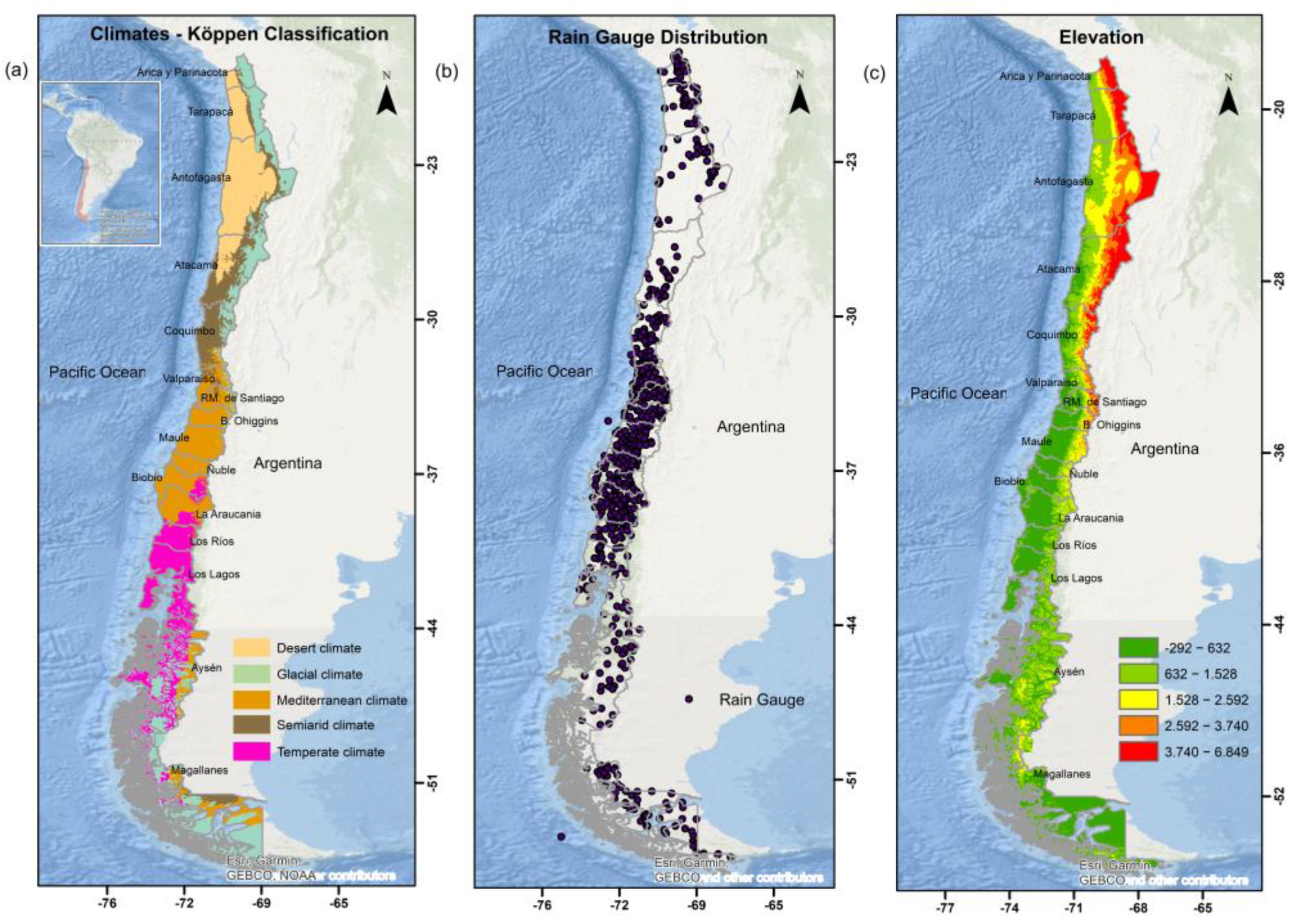
- Chile’s rain gauge network does not have a uniform density for the whole country. The stations are dense in the center of Chile, while in the north and south they are scarce. A dense gauge network would also allow better evaluation, quantifying the errors and uncertainties associated with satellite estimates.
- Some rainfall stations did not present complete data for the six years evaluated and therefore were not considered in this research.
- This study considered only the IMERG Early product, since Chile is one of the countries most vulnerable to climate change worldwide. In addition, several hazards are present in the country, including hydrometeorological events. Therefore, measuring the early-warning capability of the sensor for Chile could help in risk management. However, there is a need to carry out a comprehensive study, including Late and Final products.
- An uncertainty analysis should be carried out to determine whether the El Niño-Southern Oscillation (ENSO) cycle may influence the climate, including precipitation pattern.
- This study evidences that, despite the technological advances in remote sensing, considerable uncertainties remain in the products from the satellite mission [51,52]. Satellite precipitation estimates are often affected by random and systematic errors (bias). In this case, a systematic error correction approach based on a multiplicative bias correction factor through the ISIMIP [53] or SCALING method [54] will be included in future work.
4. Conclusions
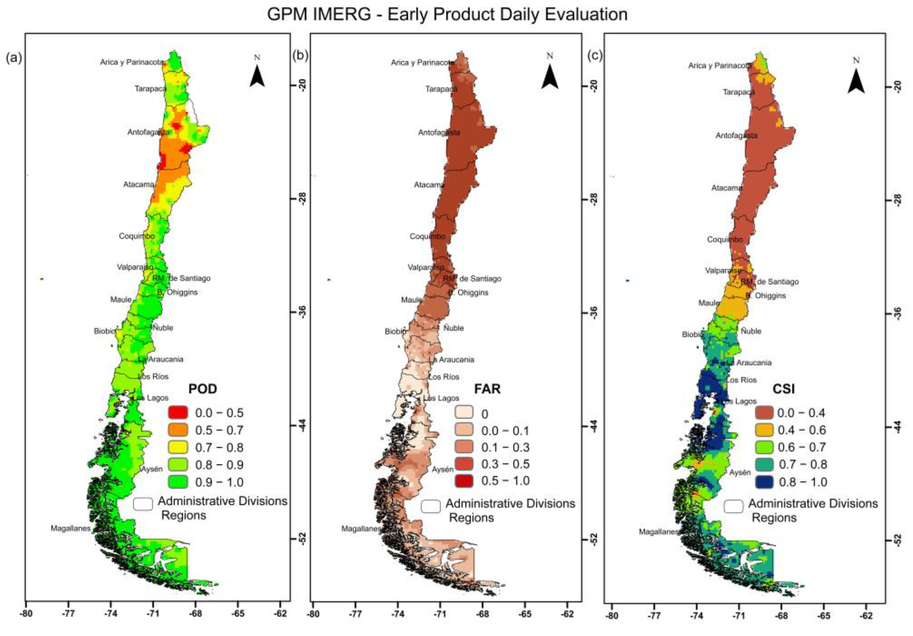
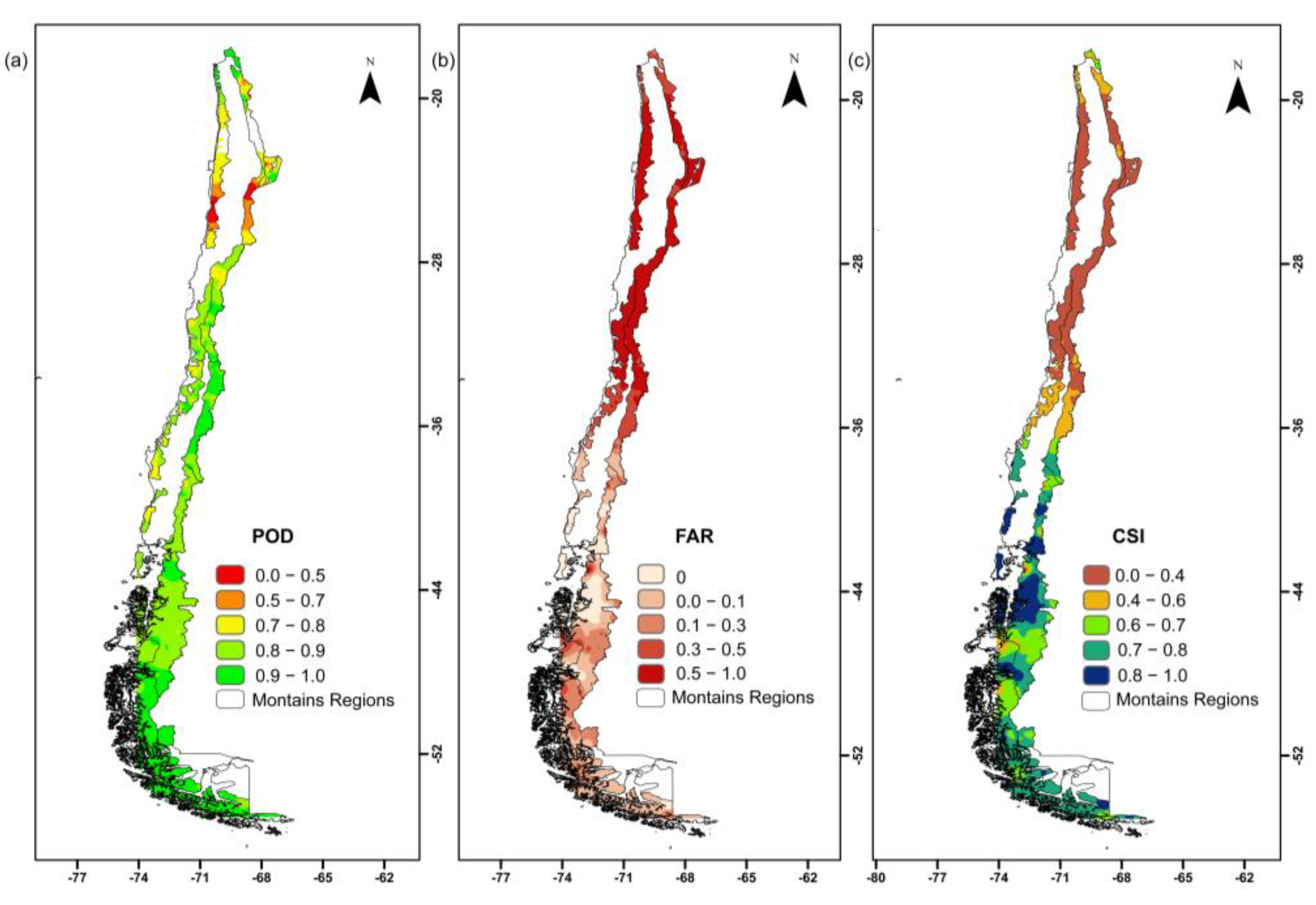
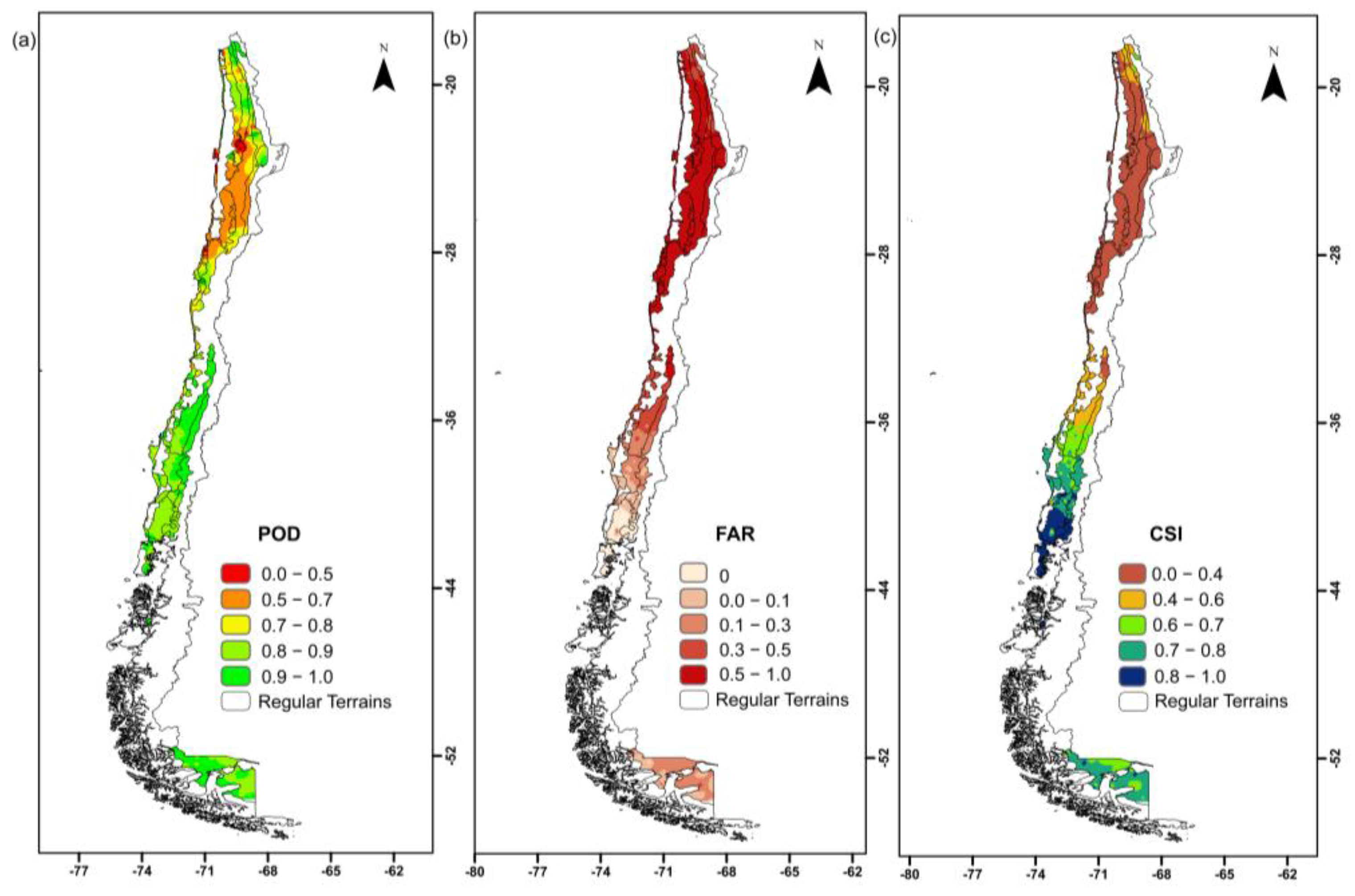
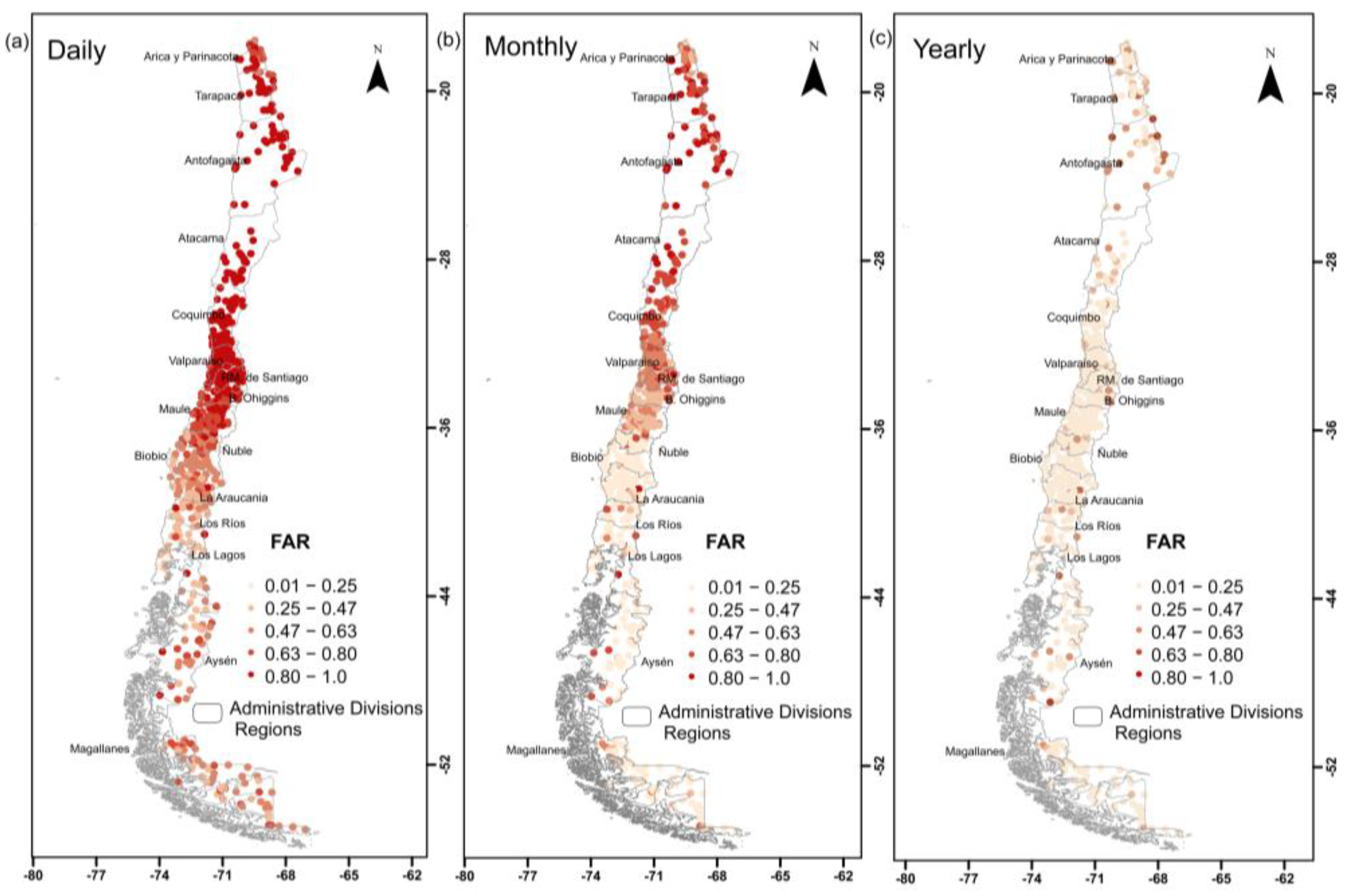
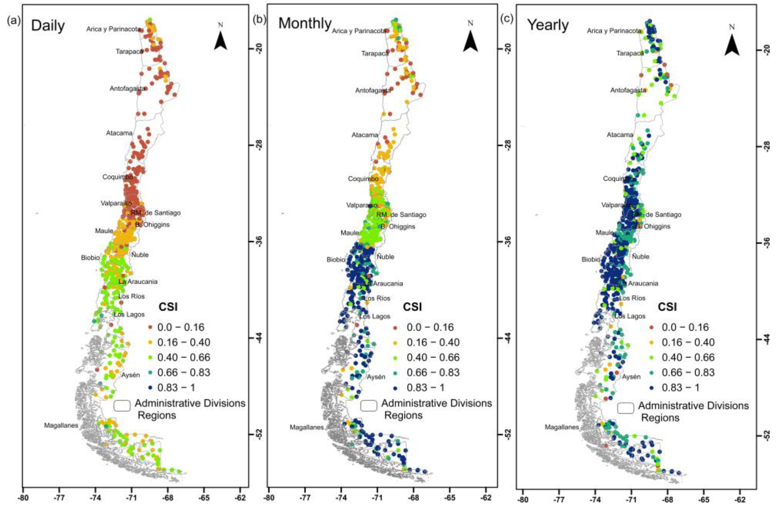
- The spatial analysis shows that the IMERG Early product has acceptable detectability for some regions, climates, and reliefs. POD and CSI values indicate that the IMERG Early product is able to detect rain, with better results from the center to the south of the country. However, FAR values are significant in the north of the country (arid region).
- The Coastal Mountain and Andes Mountains ranges presented the lowest detection accuracy.
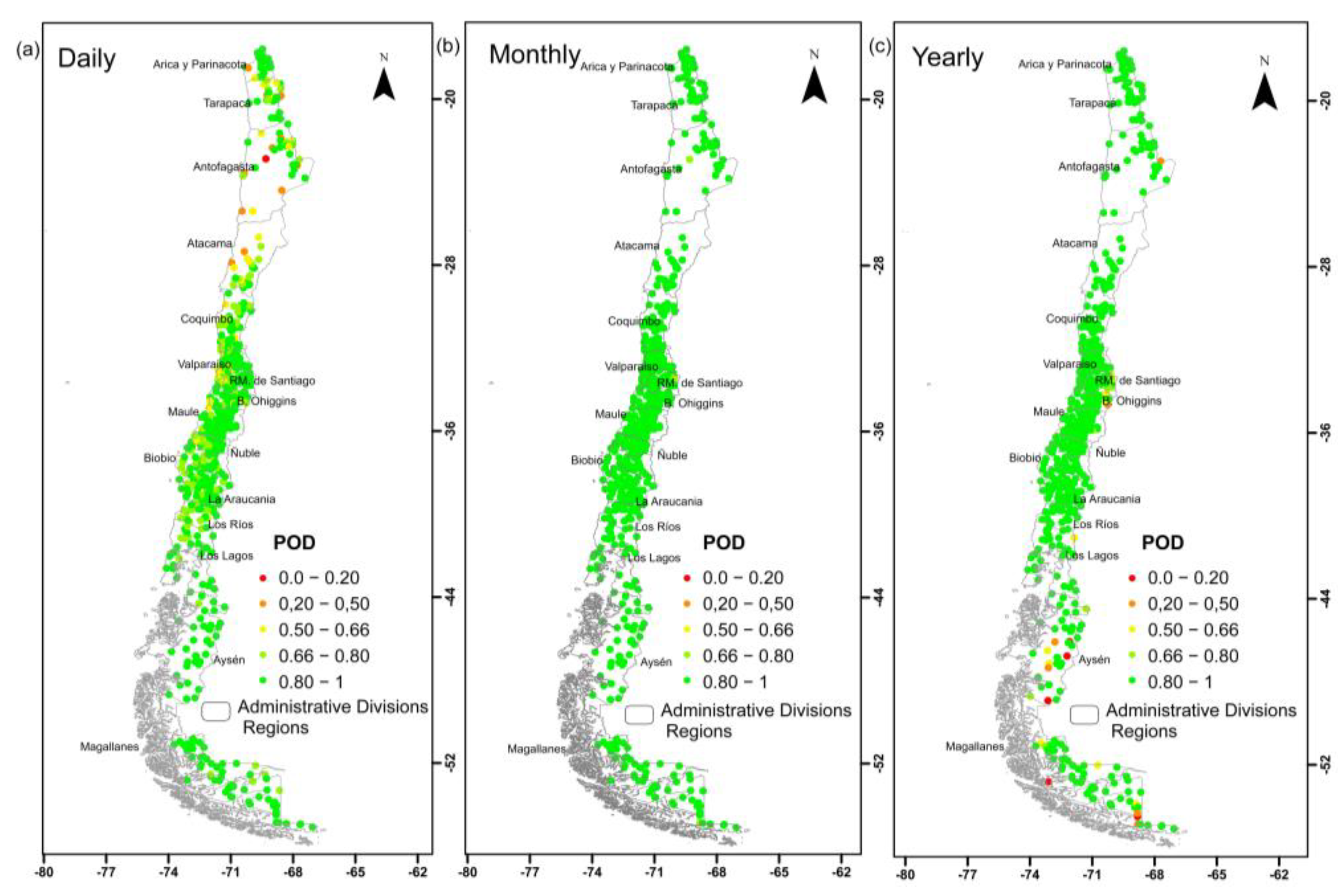
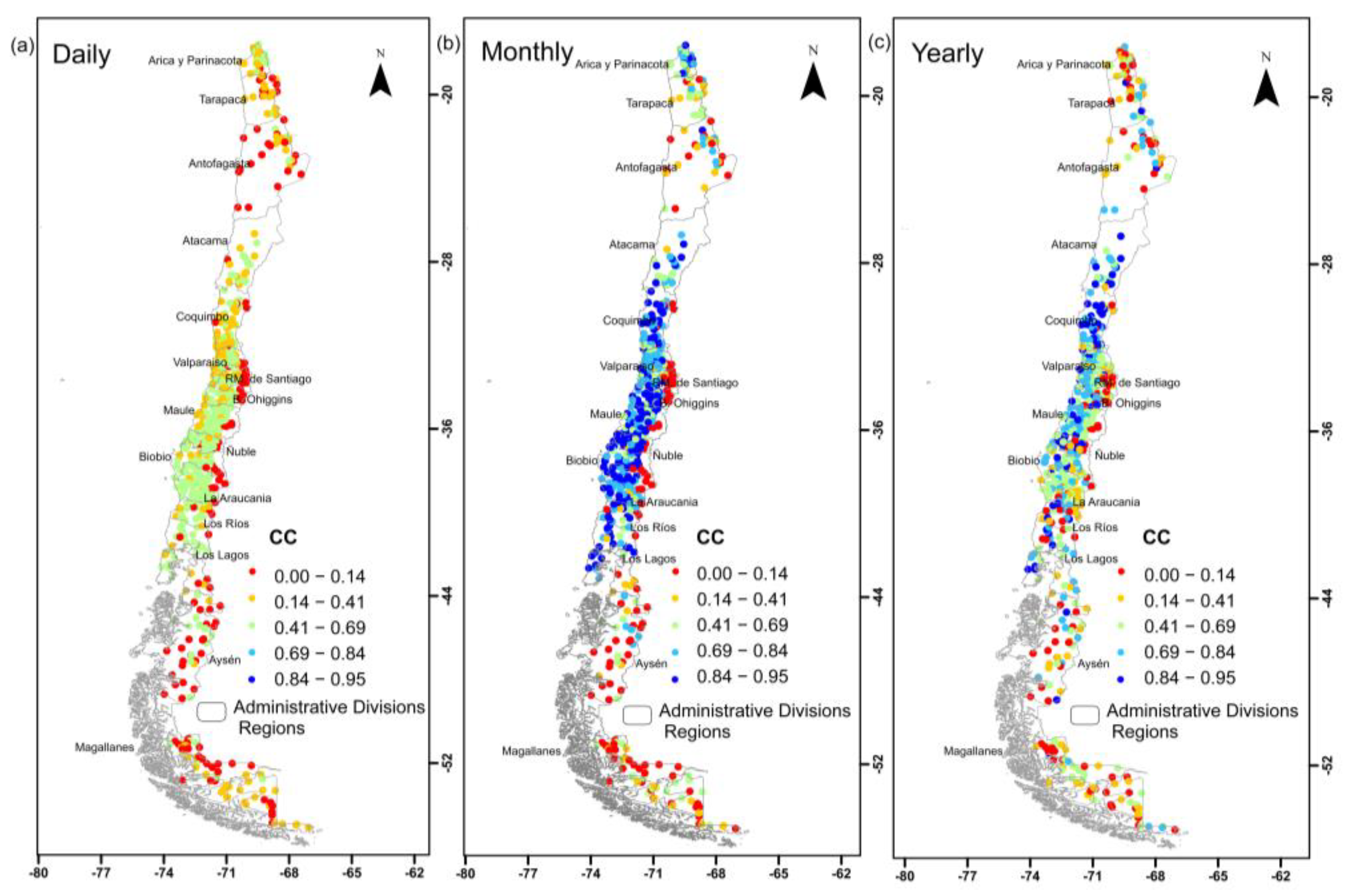
- The worst temporal performance was found for the Daily distribution compared to Monthly and Yearly data. Areas located in the Andes Mountain range showed a lower CC from the Metropolitana de Santiago to the Magallanes regions.
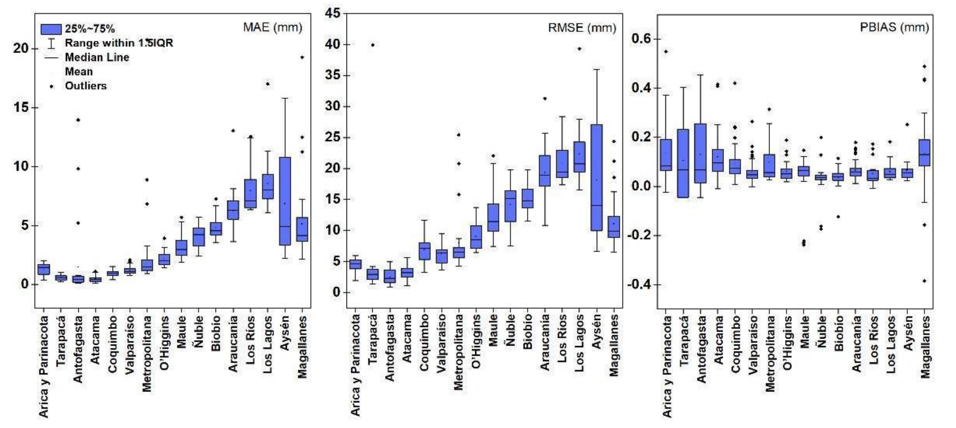
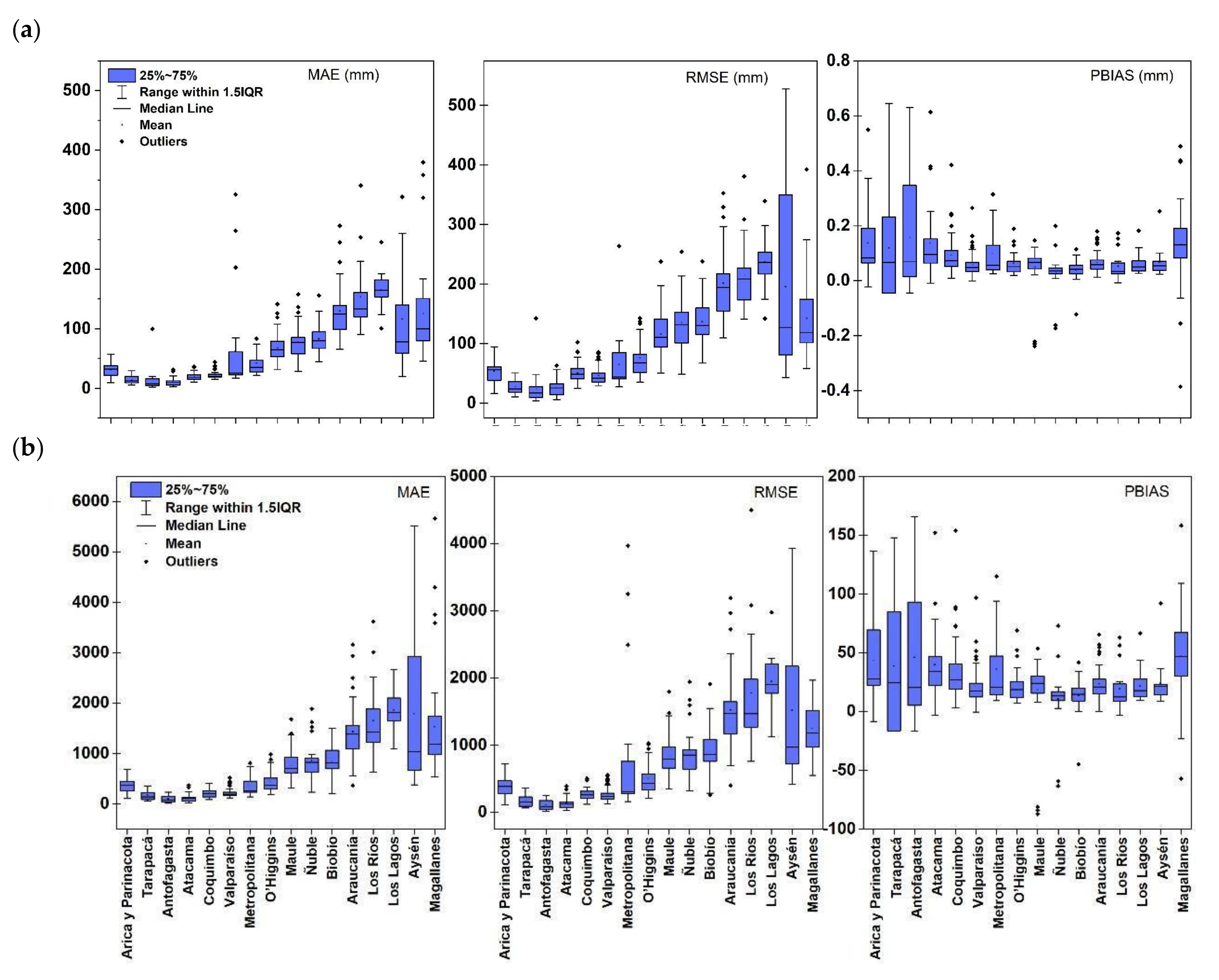
- For the three temporal distributions (Daily, Monthly, and Yearly), the errors (MAE and RMSE) showed a latitudinal increase and slightly overestimated throughout the country. The PBIAS is higher in the arid region and the Magallanes region.
Author Contributions
Funding
Data Availability Statement
Acknowledgments
Conflicts of Interest
References
- Levizzani, V.; Cattani, E. Satellite remote sensing of precipitation and the terrestrial water cycle in a changing climate. Remote Sens. 2019, 11, 2301. [Google Scholar] [CrossRef]
- D’Odorico, P.; Carr, J.; Dalin, C.; Dell’Angelo, J.; Konar, M.; Laio, F.; Ridolfi, L.; Rosa, L.; Suweis, S.; Tamea, S.; et al. Global virtual water trade and the hydrological cycle: Patterns, drivers, and socio-environmental impacts. Environ. Res. Lett. 2019, 14, 053001. [Google Scholar] [CrossRef]
- Dutta, V.; Dubey, D.; Kumar, S. Cleaning the River Ganga: Impact of lockdown on water quality and future implications on river rejuvenation strategies. Sci. Total Environ. 2020, 743, 140756. [Google Scholar] [CrossRef] [PubMed]
- Debebe, Y.; Otterpohl, R.; Islam, Z. Remote sensing and multi-criterion analysis for identifying suitable rainwater harvesting areas. Acta Geophys. 2022. [Google Scholar] [CrossRef]
- Skofronick-Jackson, G.; Kirschbaum, D.; Petersen, W.; Huffman, G.; Kidd, C.; Stocker, E.; Kakar, R. The Global Precipitation Measurement (GPM) mission’s scientific achievements and societal contributions: Reviewing four years of advanced rain and snow observations. Quart J. R. Meteoro Soc. 2018, 144, 27–48. [Google Scholar] [CrossRef]
- Del Castillo-Velarde, C.; Kumar, S.; Valdivia-Prado, J.M.; Moya-Álvarez, A.S.; Flores-Rojas, J.L.; Villalobos-Puma, E.; Martínez-Castro, D.; Silva-Vidal, Y. Evaluation of GPM Dual-Frequency Precipitation Radar Algorithms to Estimate Drop Size Distribution Parameters, Using Ground-Based Measurement over the Central Andes of Peru. Earth Syst. Environ. 2021, 5, 597–619. [Google Scholar] [CrossRef]
- Usowicz, B.; Lipiec, J.; Łukowski, M.; Słomiński, J. Improvement of spatial interpolation of precipitation distribution using cokriging incorporating rain-gauge and satellite (SMOS) soil moisture data. Remote Sens. 2021, 13, 1039. [Google Scholar] [CrossRef]
- Belete, M.; Deng, J.; Wang, K.; Zhou, M.; Zhu, E.; Shifaw, E.; Bayissa, Y. Evaluation of satellite rainfall products for modeling water yield over the source region of Blue Nile Basin. Sci. Total Environ. 2020, 708, 134834. [Google Scholar] [CrossRef]
- Kumar, P.; Debele, S.E.; Sahani, J.; Rawat, N.; Marti-Cardona, B.; Alfieri, S.M.; Basu, B.; Basu, A.S.; Bowyer, P.; Charizopoulos, N.; et al. An overview of monitoring methods for assessing the performance of nature-based solutions against natural hazards. Earth-Sci. Rev. 2021, 217. [Google Scholar] [CrossRef]
- Mahmoud, M.T.; Mohammed, S.A.; Hamouda, M.A.; Dal Maso, M.; Mohamed, M.M. Performance of the imerg precipitation products over high-latitudes region of Finland. Remote Sens. 2021, 13, 2073. [Google Scholar] [CrossRef]
- Joyce, R.J.; Janowiak, J.E.; Arkin, P.A.; Xie, P. CMORPH: A method that produces global precipitation estimates from passive microwave and infrared data at high spatial and temporal resolution. J. Hydrometeorol. 2004, 5, 487–503. [Google Scholar] [CrossRef]
- Liu, J.; Zhang, Y.; Yang, L.; Li, Y. Hydrological Modeling in the Chaohu Lake Basin of China—Driven by Open-Access Gridded Meteorological and Remote Sensing Precipitation Products. Water 2022, 14, 21. [Google Scholar] [CrossRef]
- Reddy, N.M.; Saravanan, S. Evaluation of the accuracy of seven gridded satellite precipitation products over the Godavari River basin, India. Int. J. Environ. Sci. Technol. 2022. [Google Scholar] [CrossRef]
- Noh, G.H.; Ahn, K.H. New gridded rainfall dataset over the Korean peninsula: Gap infilling, reconstruction, and validation. Int. J. Climatol. 2022, 42, 435–452. [Google Scholar] [CrossRef]
- Soto-Alvarez, M.; Alcayaga, H.; Alarcon, V.; Caamaño, D.; Palma, S.; Escanilla, R. Evaluation of products 3B42 v7 and 3IMERG for the hydroclimatic regions of Chile. J. S. Am. Earth Sci. 2020, 104, 102870. [Google Scholar] [CrossRef]
- Yucel, I.; Kuligowski, R.J.; Gochis, D.J. Evaluating the hydro-estimator satellite rainfall algorithm over a mountainous region. Int. J. Remote Sens. 2011, 32, 7315–7342. [Google Scholar] [CrossRef]
- Ingemarsson, I. Retrieving Precipitation over Brazil a Quantile Regression Neural Networks Approach. Master s Thesis, Chalmers University of Technology, Göteborg, Sweden, 2021. [Google Scholar]
- Sadeghi, M.; Asanjan, A.A.; Faridzad, M.; Gorooh, V.A.; Nguyen, P.; Hsu, K.; Sorooshian, S.; Braithwaite, D. Evaluation of PERSIANN-CDR constructed using GPCP V2.2 and V2.3 and a comparison with TRMM 3B42 V7 and CPC unified gauge-based analysis in global scale. Remote Sens. 2019, 11, 2755. [Google Scholar] [CrossRef]
- Mahmoud, M.T.; Al-Zahrani, M.A.; Sharif, H.O. Assessment of global precipitation measurement satellite products over Saudi Arabia. J. Hydrol. 2018, 559, 1–12. [Google Scholar] [CrossRef]
- Rojas, Y.; Minder, J.R.; Campbell, L.S.; Massmann, A.; Garreaud, R. Assessment of GPM IMERG satellite precipitation estimation and its dependence on microphysical rain regimes over the mountains of south-central Chile. Atmos. Res. 2021, 253, 105454. [Google Scholar] [CrossRef]
- Sharifi, E.; Steinacker, R.; Saghafian, B. Assessment of GPM-IMERG and other precipitation products against gauge data under different topographic and climatic conditions in Iran: Preliminary results. Remote Sens. 2016, 8, 135. [Google Scholar] [CrossRef]
- Maghsood, F.F.; Hashemi, H.; Hosseini, S.H.; Berndtsson, R. Ground validation of GPM IMERG precipitation products over Iran. Remote Sens. 2020, 12, 48. [Google Scholar] [CrossRef]
- Kazamias, A.P.; Sapountzis, M.; Lagouvardos, K. Evaluation of GPM-IMERG rainfall estimates at multiple temporal and spatial scales over Greece. Atmos. Res. 2022, 269, 106014. [Google Scholar] [CrossRef]
- Palharini, R.S.A.; Vila, D.A.; Rodrigues, D.T.; Quispe, D.P.; Palharini, R.C.; de Siqueira, R.A.; de Sousa Afonso, J.M. Assessment of the extreme precipitation by satellite estimates over South America. Remote Sens. 2020, 12, 2085. [Google Scholar] [CrossRef]
- Junqueira, R.; Viola, M.R.; da S.; Amorim, J.; Camargos, C.; de Mello, C.R. Hydrological modeling using remote sensing precipitation data in a Brazilian savanna basin. J. S. Am. Earth Sci. 2022, 115, 103773. [Google Scholar] [CrossRef]
- Laverde-Barajas, M.; Corzo Perez, G.A.; Dalfré Filho, J.G.; Solomatine, D.P. Assessing the performance of near real-time rainfall products to represent spatiotemporal characteristics of extreme events: Case study of a subtropical catchment in south-eastern Brazil. Int. J. Remote Sens. 2018, 39, 7568–7586. [Google Scholar] [CrossRef]
- da S. Freitas, E.; Coelho, V.H.R.; Xuan, Y.; Melo, D.d.C.D.; Gadelha, A.N.; Santos, E.A.; Galvão, C.d.O.; Ramos Filho, G.M.; Barbosa, L.R.; Huffman, G.J.; et al. The performance of the IMERG satellite-based product in identifying sub-daily rainfall events and their properties. J. Hydrol. 2020, 589, 125128. [Google Scholar] [CrossRef]
- Mahmoud, M.T.; Mohammed, S.A.; Hamouda, M.A.; Mohamed, M.M. Impact of topography and rainfall intensity on the accuracy of imerg precipitation estimates in an arid region. Remote Sens. 2021, 13, 13. [Google Scholar] [CrossRef]
- Mahmoud, M.T.; Hamouda, M.A.; Mohamed, M.M. Spatiotemporal evaluation of the GPM satellite precipitation products over the United Arab Emirates. Atmos. Res. 2019, 219, 200–212. [Google Scholar] [CrossRef]
- Yu, X.; Shi, J.; Feng, L.; Li, C.; Wang, L. A three-dimensional BiOBr/RGO heterostructural aerogel with enhanced and selective photocatalytic properties under visible light. Appl. Surf. Sci. 2017, 396, 1775–1782. [Google Scholar] [CrossRef]
- Delgado, D.; Sadaoui, M.; Ludwig, W.; Méndez, W. Spatio-temporal assessment of rainfall erosivity in Ecuador based on RUSLE using satellite-based high frequency GPM-IMERG precipitation data. Catena 2022, 219, 106597. [Google Scholar] [CrossRef]
- Shahid, M.; Rahman, K.U.; Haider, S.; Gabriel, H.F.; Khan, A.J.; Pham, Q.B.; Mohammadi, B.; Linh, N.T.; Anh, D.T. Assessing the potential and hydrological usefulness of the CHIRPS precipitation dataset over a complex topography in Pakistan. Atmos. Res. 2021, 66, 1664–1684. [Google Scholar] [CrossRef]
- Valenzuela, R.; Garreaud, R.; Vergara, I.; Campos, D.; Viale, M.; Rondanelli, R. An extraordinary dry season precipitation event in the subtropical Andes: Drivers, impacts and predictability. Weather Clim. Extrem. 2022, 37, 100472. [Google Scholar] [CrossRef]
- Bulovic, N.; McIntyre, N.; Johnson, F. Evaluation of imerg v05b 30-min rainfall estimates over the high-elevation tropical andes mountains. J. Hydrometeorol. 2020, 21, 2875–2892. [Google Scholar] [CrossRef]
- Navarro, A.; García-Ortega, E.; Merino, A.; Sánchez, J.L.; Tapiador, F.J. Orographic biases in IMERG precipitation estimates in the Ebro River basin (Spain): The effects of rain gauge density and altitude. Atmos. Res. 2020, 244, 105068. [Google Scholar] [CrossRef]
- Navarro, A.; García-Ortega, E.; Merino, A.; Sánchez, J.L.; Kummerow, C.; Tapiador, F.J. Assessment of IMERG precipitation estimates over Europe. Remote Sens. 2019, 11, 2470. [Google Scholar] [CrossRef]
- Sarricolea, P.; Herrera-Ossandon, M.; Meseguer-Ruiz, Ó. Climatic regionalisation of continental Chile. J. Maps 2017, 13, 66–73. [Google Scholar] [CrossRef]
- IDE Ministerio de Bienes Nacionales Chile, infraestructura de datos Geoespaciales. Available online: http://www.ide.cl/ (accessed on 30 October 2022).
- Scherrer, S.C.; Frei, C.; Croci-Maspoli, M.; van Geijtenbeek, D.; Hotz, C.; Appenzeller, C. Operational quality control of daily precipitation using spatio-climatological plausibility testing. Meteorol. Zeitschrift 2011, 20, 397–407. [Google Scholar] [CrossRef]
- Estévez, J.; Llabrés-Brustenga, A.; Casas-Castillo, M.C.; García-Marín, A.P.; Kirchner, R.; Rodríguez-Solà, R. A quality control procedure for long-term series of daily precipitation data in a semiarid environment. Theor. Appl. Climatol. 2022, 149, 1029–1041. [Google Scholar] [CrossRef]
- Dirección General de Aguas Actualización del Balance Hídrico Nacional: Resumen Ejecutivo. Santiago de Chile, Chile, 2017; 61.
- Barrett, B.S.; Hameed, S. Seasonal variability in precipitation in central and southern Chile: Modulation by the South Pacific high. J. Clim. 2017, 30, 55–69. [Google Scholar] [CrossRef]
- Ramadhan, R.; Yusnaini, H.; Marzuki, M.; Muharsyah, R.; Suryanto, W.; Sholihun, S.; Vonnisa, M.; Harmadi, H.; Ningsih, A.P.; Battaglia, A.; et al. Evaluation of GPM IMERG Performance Using Gauge Data over Indonesian Maritime Continent at Different Time Scales. Remote Sens. 2022, 14, 1172. [Google Scholar] [CrossRef]
- Anagnostou, E.; Mei, Y. Using high-resolution satellite precipitation for flood frequency analysis: Case study over the Connecticut River Basin. J. Flood Risk Manag. 2018, 11, S514–S526. [Google Scholar]
- Valenzuela, R.A.; Garreaud, R.D. Extreme daily rainfall in central-southern Chile and its relationship with low-level horizontal water vapor fluxes. J. Hydrometeorol. 2019, 20, 1829–1850. [Google Scholar] [CrossRef]
- Li, Y.; Grimaldi, S.; Walker, J.P.; Pauwels, V.R.N. Application of remote sensing data to constrain operational rainfall-driven flood forecasting: A review. Remote Sens. 2016, 8, 456. [Google Scholar] [CrossRef]
- Zambrano, F.; Wardlow, B.; Tadesse, T.; Lillo-Saavedra, M.; Lagos, O. Evaluating satellite-derived long-term historical precipitation datasets for drought monitoring in Chile. Atmos. Res. 2017, 186, 26–42. [Google Scholar] [CrossRef]
- Fustos, I.; Abarca-del-Río, R.; Mardones, M.; González, L.; Araya, L.R. Rainfall-induced landslide identification using numerical modelling: A southern Chile case. J. S. Am. Earth Sci. 2020, 101, 102587. [Google Scholar] [CrossRef]
- Schumann, G.; Kirschbaum, D.; Anderson, E.; Rashid, K. Role of Earth observation data in disaster response and recovery: From science to capacity building. In Earth Science Satellite Applications; Springer: Cham, Switzerland, 2016. [Google Scholar]
- Li, Z.; Chen, M.; Gao, S.; Hong, Z.; Tang, G.; Wen, Y.; Gourley, J.J.; Hong, Y. Cross-examination of similarity, difference and deficiency of gauge, radar and satellite precipitation measuring uncertainties for extreme events using conventional metrics and multiplicative triple collocation. Remote Sens. 2020, 12, 1258. [Google Scholar] [CrossRef]
- Nikolopoulos, E.I.; Crema, S.; Marchi, L.; Marra, F.; Guzzetti, F.; Borga, M. Impact of uncertainty in rainfall estimation on the identification of rainfall thresholds for debris flow occurrence. Geomorphology 2014, 221, 286–297. [Google Scholar] [CrossRef]
- Tapiador, F.J.; Navarro, A.; Levizzani, V.; García-Ortega, E.; Huffman, G.J.; Kidd, C.; Kucera, P.A.; Kummerow, C.D.; Masunaga, H.; Petersen, W.A.; et al. Global precipitation measurements for validating climate models. Atmos. Res. 2017, 197, 1–20. [Google Scholar] [CrossRef]
- Hempel, S.; Frieler, K.; Warszawski, L.; Schewe, J.; Piontek, F. A trend-preserving bias correction – The ISI-MIP approach. Earth Syst. Dyn. 2013, 4, 219–236. [Google Scholar] [CrossRef]
- Wetterhall, F.; Pappenberger, F.; He, Y.; Freer, J.; Cloke, H.L. Conditioning model output statistics of regional climate model precipitation on circulation patterns. Nonlinear Process. Geophys. 2012, 19, 623–633. [Google Scholar] [CrossRef]
| Administrative Region | Number of Stations | Density per Km | Annual Precipitation |
|---|---|---|---|
| Antofagasta | 38 | 0.0003 | 100 |
| Araucania | 55 | 0.0017 | 3000 |
| Arica y Parinacota | 27 | 0.0016 | 3 |
| Atacama | 28 | 0.0004 | 250 |
| Aysén | 39 | 0.0004 | 4266 |
| Biobío | 40 | 0.0017 | 2000 |
| Coquimbo | 65 | 0.0016 | 130 |
| Los Lagos | 29 | 0.0006 | 3514 |
| Los Rios | 23 | 0.0013 | 3056 |
| Magallanes | 66 | 0.0005 | 3500 |
| Maule | 55 | 0.0018 | 792 |
| Metropolitana (RM) de Santiago | 43 | 0.0028 | 356 |
| Ñuble | 28 | 0.0021 | 1500 |
| O’Higgins | 30 | 0.0018 | 739 |
| Tarapacá | 23 | 0.0005 | 8 |
| Valparaíso | 62 | 0.0038 | 450 |
Disclaimer/Publisher’s Note: The statements, opinions and data contained in all publications are solely those of the individual author(s) and contributor(s) and not of MDPI and/or the editor(s). MDPI and/or the editor(s) disclaim responsibility for any injury to people or property resulting from any ideas, methods, instructions or products referred to in the content. |
© 2023 by the authors. Licensee MDPI, Basel, Switzerland. This article is an open access article distributed under the terms and conditions of the Creative Commons Attribution (CC BY) license (https://creativecommons.org/licenses/by/4.0/).
Share and Cite
da Silva, L.d.D.d.J.; Mahmoud, M.; González-Rodríguez, L.; Mohammed, S.; Rodríguez-López, L.; Arias, M.I.A. Assessment of the IMERG Early-Run Precipitation Estimates over South American Country of Chile. Remote Sens. 2023, 15, 573. https://doi.org/10.3390/rs15030573
da Silva LdDdJ, Mahmoud M, González-Rodríguez L, Mohammed S, Rodríguez-López L, Arias MIA. Assessment of the IMERG Early-Run Precipitation Estimates over South American Country of Chile. Remote Sensing. 2023; 15(3):573. https://doi.org/10.3390/rs15030573
Chicago/Turabian Styleda Silva, Luciana das Dores de Jesus, Mohammed Mahmoud, Lisdelys González-Rodríguez, Safa Mohammed, Lien Rodríguez-López, and Mauricio Ivan Aguayo Arias. 2023. "Assessment of the IMERG Early-Run Precipitation Estimates over South American Country of Chile" Remote Sensing 15, no. 3: 573. https://doi.org/10.3390/rs15030573
APA Styleda Silva, L. d. D. d. J., Mahmoud, M., González-Rodríguez, L., Mohammed, S., Rodríguez-López, L., & Arias, M. I. A. (2023). Assessment of the IMERG Early-Run Precipitation Estimates over South American Country of Chile. Remote Sensing, 15(3), 573. https://doi.org/10.3390/rs15030573


