Article

Mapping Multi-Depth Soil Salinity Using Remote Sensing-Enabled Machine Learning in the Yellow River Delta, China

1
School of Water Conservancy and Environment, University of Jinan, Jinan 250022, China
2
Zhongke Shandong Dongying Institute of Geographic Sciences, Dongying 257509, China
3
Rural Economic Management Service Station of Shandong Province, Jinan 250013, China
4
State Key Laboratory of Resources and Environmental Information System, Institute of Geographic Sciences and Natural Resources Research, Chinese Academy of Sciences, Beijing 100101, China
*
Author to whom correspondence should be addressed.
Remote Sens. 2023, 15(24), 5640; https://doi.org/10.3390/rs15245640
Submission received: 20 October 2023 / Revised: 26 November 2023 / Accepted: 1 December 2023 / Published: 6 December 2023
(This article belongs to the Section Ecological Remote Sensing)

Abstract

:
Soil salinization is a crucial type in the degradation of coastal land, but its spatial distribution and drivers have not been sufficiently explored especially at the depth scale owing to its multidimensional nature. In this study, we proposed a multi-depth soil salinity prediction model (0–10 cm, 10–20 cm, 20–40 cm, and 40–60 cm) fully using the advantages of satellite image data and field sampling to rapidly estimate the multi-depth soil salinity in the Yellow River Delta, China. Firstly, a multi-depth soil salinity predictive factor system was developed through correlation analysis of soil sample electrical conductivity with a series of remote-sensing parameters containing heat, moisture, salinity, vegetation indices, spectral value, and spatial location. Then, three machine learning methods including back propagation neural network (BPNN), support vector machine (SVM), and random forest (RF) were adopted to construct a coastal soil salinity inversion model. By using the best inversion model, we obtain the spatial distribution of soil salinity in the Yellow River Delta. The results show the following: (1) Environmental variables in this study are all effective variables for soil salinity prediction. The most sensitive indicators to multi-depth soil salinity are GDVI, ENDVI, SI-T, NDWI, and LST. (2) The RF model was chosen as the optimal approach for predicting and mapping soil salinity based on performance at four soil depths. (3) The soil salinity profiles exhibited intricate coexistence of two distinct types: surface aggregated and homogeneous. The former was dominant in the east, where salinity was higher. The central and southwestern parts were mostly homogeneous, with lower soil salinity. (4) The soil salinity throughout the four depths examined was found to be most elevated in saltern and bare land and lowest in wetland vegetation and farmland, according to land-cover type. This study proposed a remote sensing prediction method for salinization in multiple soil layers in the coastal plain, which could provide decision support for spatial monitoring of land salinization and achieving land degradation neutrality targets.

1. Introduction

Soil salinization is a common and increasingly serious kind of soil degradation across the world. Globally, there are approximately 9.5 × 10⁹ ha of saline–alkali land spread over more than 100 nations and regions [1,2,3,4]. The Yellow River Delta represents a prototypical coastal region in China that is significantly impacted by soil salinization. The equilibrium between soil moisture and salt content in this region has been upset by both natural influences, including seawater intrusion and a high rate of evaporation, and human influences, including inappropriate irrigation and excessive reclamation. Consequently, primary saline soils exhibit a wide distribution, but secondary salinization is a regular occurrence [5,6]. Soil salinization has been seen to impact more than 20% of agricultural fields. It can damage soil quality, affect plant growth, damage the ecological environment, and cause production losses. The issue has emerged as a significant impediment to the advancement of agricultural productivity and the attainment of sustainable social and economic progress [7,8]. Therefore, the distribution of soil salinity needs to be comprehensively understood to address soil health status, ecological environmental issues, and food insecurity [9].
Soil salinity research frequently requires the manual collection of soil samples, followed by laboratory trials. However, this strategy is time-consuming and difficult to perform in tough-to-reach locations, such as wetlands and swamps, resulting in a scarcity of recorded data in such specific areas [10]. To obtain more comprehensive data, several studies utilized existing measured data on soil salinity and paired them with a spatial interpolation geostatistical method to analyze the geographical distribution of soil salinity [11,12,13]. Nevertheless, the geographical distribution that results from spatial interpolation is frequently approximate and difficult to match with the features of real objects. This barrier has been overcome by the quick advancement of remote sensing technologies [14,15,16]. Numerous studies have proved the significant potential of remote sensing as a valuable instrument for soil salinity evaluating. The combination of field sample data with remote sensing technologies, along with the utilization of spectral indicators for the development of inversion models, has emerged as a valuable approach for the digital cartography of soil salinization [17,18].
The use of remote sensing has presented novel prospects for evaluating soil salinization. However, the intricate nature of this endeavor underscores the necessity for the development of mapping methodologies [19]. The advancement of machine learning has significantly contributed to the development of more robust methodologies for digital soil mapping, providing reliable predictive tools for salinization assessment [20]. These methods can perform nonparametric feature extraction in high-dimensional spaces or vote for preferred values by generating ensembles of decision trees that produce robust, low-bias, and low-covariance results [21]. Numerous studies have employed various machine learning techniques and have frequently remarked on the models’ excellent performance. To predict soil salinity, for instance, support vector machine [10,22,23], neural network [24,25], and random forest [26,27] have all been employed, and good performance has been noted for these selected models. These methodologies provide more precise outcomes compared to linear or geostatistical techniques [28,29].
At present, extensive research has been conducted on the issue of salinization, mainly focusing on simulating and analyzing surface salinization [30,31]. In China, research on multi-depth soil salinity is mostly concentrated in the flooded areas of the Yellow River in Henan and the Hetao Irrigation Area in Inner Mongolia. Researchers in these two regions have constructed soil salinity inversion models at different depths based on remote sensing images and soil salinity data at different depths [32,33]. The process of salt accumulation and desalination in saline soil varies with time and space, and the degree of salinization varies in different locations and soil layers. Overall, there is still limited research on the distribution of multi-depth soil salinity in the coastal area of the Yellow River Delta, making it difficult to meet the current needs of efficient ecological and economic development in the Yellow River Delta. The vertical variation of soil salinity in coastal areas with shallow groundwater is considerable, making it suitable for studying the distribution of salt salinity at different soil depths.
This research employed a combination of machine learning techniques and remote sensing to quantify the levels of soil salinity across numerous soil layers. The primary aims of this objective were to: (1) examine the correlation of different environmental variables with soil salinity at different depths and explore the impact of those environmental factors on multi-depth spatialized soil salinity in coastal areas; (2) propose the most appropriate machine learning-based model for accurately and rapidly predicting multi-depth soil salinity using macroscale-based remote sensing information by evaluating the accuracy of various methods; and (3) produce detailed soil salinity maps at various depths and analyze the spatial patterns of soil salinity in study area.

2. Materials and Methods

2.1. Study Area

The Kenli district, situated in Dongying City of the Shandong Province in China, is positioned near the Yellow River estuary, which flows into the Bohai Sea (Figure 1). The area exhibits a warm temperate continental monsoon climate. During the summer season, high temperatures and precipitation dominate, while the winter season is characterized by low temperatures and aridity, with seasonal salt reflux and accumulation. Kenli District has typical delta geomorphic characteristics. The shallow groundwater level, high salinity, and strong soil capillary effect result in severe soil salinization and widely distributed saline soil. The soil types are primarily alluvial and coastal saline. The soil texture classes of the cultivation layer are primarily sandy and light, with the soil composition predominantly composed of sandstone. The land-use categories in this region include farmland, construction land, water bodies, wetland vegetation, salterns, and bare land. The dominant land-use type is cultivated land. Wheat, corn, and cotton are the predominant agricultural crops in this region.
At the end of May, it was the transitional period from spring to summer, and much vegetation were in a period of vigorous growth. At this point, the salt in the soil may have a significant impact on crops or natural vegetation, so the impact of soil salt on crops and natural vegetation can be more accurately evaluated. During this period, the rainfall in the region was low and the temperature increased, leading to an increase in evaporation rate. These may have led to the accumulation of soil salts in the top layer of the soil, helping to improve the accuracy of remote sensing for monitoring soil salinity.

2.2. Data Sources

2.2.1. Soil Sampling and Laboratory Analysis

Field sampling was conducted from 28 May 2022 to 1 June 2022. The sample plots were designed using the grid method, and each grid cell was 5 × 5 km, considering both sample plot accessibility and coverage of all land-use types. A total of 89 sampling sites were investigated, as depicted in Figure 1. The five-point sampling approach was employed to gather a total of five soil samples at each designated sampling location. These individual samples were subsequently combined on site to provide a composite sample that accurately represents the overall soil composition. The geographical coordinates of each sampling site were determined by employing a global positioning system device. The soil samples were prepared by air-drying, grinding, and sieving, and three 20.00 g soil samples at each sampling point were weighed to prepare three soil solutions (the ratio of soil to distilled water was 1:5). After stirring, standing, precipitation, and filtration, the electrical conductivity value EC 1:5 of the supernatant in the soil solution was determined using a LeiCi DDS-307 conductivity meter (manufactured by ShengKe, Shanghai, China). The average of the three measurements was taken as the final conductivity value [34,35]. EC is given in dS/m and is widely used as a reliable indicator of soil salinity level [10].

2.2.2. Remote Sensing Data and Processing

The Landsat 9 remote sensing image data used in the research was sourced from the official website of the United States Geological Survey (https://earthexplorer.usgs.gov (accessed on 21 July 2022)), and the satellite was successfully launched on 27 September 2021. The satellite is equipped with an operational land imager 2 (OLI-2) and a thermal infrared sensor 2 (TIRS-2). The OLI-2 sensor offers a total of 8 spectral bands with a spatial resolution of 30 m, along with an additional panchromatic band of 15 m. TIRS offers two thermal infrared bands with a spatial resolution of 100 m. Compared to other satellites, Landsat 9 has thermal infrared bands that can provide more accurate surface temperature measurements [25]. The process of radiation and atmospheric corrections was executed using the Radiometric Calibration and Fast Line-of-sight Atmospheric Analysis of Spectral Hypercubes (FLAASH) within the ENVI 5.4 software. These calibrated radiance and reflectance datasets served as the foundation for establishing the essential environmental variables.

2.3. Research Method

To quickly estimate multi-depth soil salinity in coastal areas, we proposed a multi depth soil salinity reconstruction model using satellite data and measured data (Figure 2). The method consisted of three parts: (1) Field sampling was conducted to obtain soil salinity data, and five possible variables related to soil salinity were extracted from species in Landsat 9 images. (2) The correlation between soil salinity and environmental variables was analyzed, and variables with a correlation coefficient of |r| > 0.3 were identified as sensitive parameters. The set of sensitive parameters formed a multi-depth soil salinity predictive factor system, and the predictive factors for each soil layer were input into a machine learning model to determine the optimal inversion model for each soil layer. (3) The optimal model was used to predict the salinity of each layer of soil.

2.3.1. Environmental Variables

Spectral Value

The spectral value refers to raw spectral information, and the reflectance of different bands represents different surface characteristics. The bands exhibit a strong association with soil salinity [36]. In the present study, nine bands were chosen as predictors from the raw spectral information provided by Landsat 9, including B1, B2, B3, B4, B5, B6, B7, B10, and B11. As B8 belongs to the panchromatic band and B9 belongs to the cirrus band, neither was employed as a predictor.

Salinity Index

The salinity index is a metric that has been developed to reflect the salinization status of soil [14]. To characterize soil salinization, this study compiled the findings of different scholars in this field and summarized the multiple salinity indices produced through band calculations. The formulas for these indices are listed in Table 1.

Vegetation Index

The vegetation index evaluates the growth state of vegetation by monitoring vegetation cover and chlorophyll content [42]. The level of salinization can be determined based on the changes in vegetation indices because soil salinization influences vegetative conditions. Certain vegetation indices incorporate supplementary spectral data to improve the association between vegetation and soil salinity, thereby facilitating more precise assessment of soil salinization levels. The vegetation indices selected for this study are presented in Table 2 and were obtained using band calculations. These indices facilitated a more comprehensive investigation of soil salinization levels and provided substantial support for this study.

Heat and Moisture Indices

Temperature and humidity are essential variables in terrestrial ecology and hydrological processes. They play vital roles in ecosystem processes such as soil solute transport, vegetation growth, and energy cycling. The transport of soluble salts in the soil are subject to variations in land-surface temperature and humidity, subsequently impacting land ecology and agricultural productivity. The land-surface temperature (LST) was obtained using a mono-window technique [53]. Additionally, we employed the normalized difference water index (NDWI) to evaluate the moisture content of the soil promptly and precisely. The NDWI was calculated using the approach described by Gu et al. [54].

Spatial Location

The spatial location refers to the relative locations with respect to common land features associated with soil salinity. This information was derived by spatial analysis utilizing remote sensing data. The ocean is the most distinctive and significant feature affecting the research area. Coastal erosion and seawater intrusion have a significant impact on natural ecosystems and serve as primary contributors to the salinization of coastal soil [55]. The construction of salterns and aquaculture farms may result in salt buildup and an increase in the salinity of nearby soil [56]. Although saline water irrigation has certain benefits for crops, the salts introduced through irrigation water can also accumulate in the soil, which can further aggravate soil salinization if drainage measures are not appropriate [57]. Therefore, typical soil salinity-related land features such as the sea, salterns, and farmland were chosen. The Euclidean Distance tool in ArcGIS 10.8 was used to calculate the distances to the coastline (DTC), saltern (DTS), and farmland (DTF), which will be input into the model as environmental variables.

2.3.2. Environmental Variable Selection

The Pearson correlation analysis method is used to select environmental variables [34,58]. The Pearson correlation coefficient (PCC) is a statistical metric utilized to assess the correlation between two variables, ranging from −1 to 1. The larger the absolute value of the correlation coefficient |r|, the greater the correlation between them. The utilization of this approach is prevalent in the process of variable selection and has proven to be highly efficient in reducing redundant variables [18]. Based on the magnitude of the values, we categorized the absolute value of the correlation coefficient into three levels: weak (≤0.3), intermediate (>0.3 and ≤0.6), and strong (>0.6). Finally, environmental variables with the absolute value of correlation coefficients >0.3 were chosen as input factors for the prediction model for subsequent analysis [59]. The Pearson correlation coefficient value (r) can be calculated using Formula (1):
r = i = 1 n X i X ¯ Y i Y ¯ i = 1 n X i X ¯ 2 i = 1 n Y i Y ¯ 2
where X i and Y i represent the values of two input attributes and X represent the mean values of them.

2.3.3. Estimating Algorithms

Multiple factors affect soil salinity in research region, with the specific impacting elements differing for different soil depths. Hence, developing machine learning methods that are tailored to certain depths is imperative. To ascertain the optimal model for soil salinity prediction, three machine learning algorithms, namely BPNN, SVM, and RF, were utilized. These algorithms have previously exhibited effectiveness in simulating soil salinity [60,61].

Backpropagation Neural Network

The BPNN algorithm proposed by Rumelhart is a powerful neural network algorithm capable of nonlinear mapping [62]. The algorithm utilizes an error BPNN technique to iteratively update the internal network parameters, aiming to minimize the gap between the predicted outputs and the actual values [63]. The current investigation employed the BPNN model to predict soil salinity. Environmental variables were designated as inputs, and soil salinity was the output. The parameters used during BPNN construction are shown in Table 3. To mitigate the influence of varying data dimensions on the analysis, normalization was performed on both the input and output layers (the same approach was applied to the other three models). All three models were implemented in MATLAB R2021b.

Support Vector Machine

SVM was first proposed by Vapnik [64]. SVM uses kernel functions to avoid overfitting and other issues as much as possible. Based on whether SVM solves problems continuously, it can be divided into an SVM for classification (SVC) or for regression (SVR). Among them, SVC is used to solve discrete classification problems, and SVR is used for regression prediction problems for continuous data. Based on SVC, an insensitive loss function is introduced to reduce the discrepancy between the best classification surface and all training samples to obtain an SVR [10]. The SVM model was constructed using the MATLAB R2021b LibSVM toolkit. The “-t” kernel function type was selected as the RBF kernel function. The SVM type “-s” was selected as the e-SVR type, and the value of the loss function “-p” in the e-SVR type was set to 0.01. We used the grid search cross-validation method to iterate the values of c and g and obtained the best values for these parameters as shown in Table 3.

Random Forest

The RF regression algorithm was proposed by Breiman [65]. Due to its exceptional performance, it has been extensive in the domain of data mining and is frequently employed in soil salinity simulations [66,67]. The randomness of RF is manifested in two aspects: one is the generation of training sample sets through self-service resampling technology, and the other is the random selection of split attribute sets for each node in the tree, which creates good noise resistance for RF. RF is an ensemble learning method that combines many decision trees. Each decision tree in the RF is trained using a randomly generated dataset derived from the original dataset. The outcome of a random forest decision is determined by aggregating the decision results of many decision trees. When constructing the RF regression model, the performance is influenced by two significant parameters: the quantity of decision trees and the number of attribute values at each node. After multiple tests, the parameter settings for the four soil layers have been determined as shown in Table 3.

2.3.4. Uncertainty and Accuracy Analysis

A five-fold cross validation approach was utilized to validate the uncertainty and accuracy of all three algorithms implemented in this study [26,68]. The mean values and standard deviations (SDs) of the simulated results were considered as the final simulation results and uncertainty of the algorithm, respectively. Then, the coefficient of determination (R2) and root mean square error (RMSE) between predicting and observing soil salinity were used to assess the performance of the model [29]. The R2, RMSE, and SD were calculated as follows:
R 2 = 1 i = 1 n y ^ i y i 2 i = 1 n y i ¯ y i 2
R M S E = i = 1 n ( y i y ^ i ) 2 n
S D = i = 1 n ( V i M V ) 2 n
where y i is the measured soil salinity, y ^ i is the predicted soil salinity, y ¯ i is the average measured soil salinity, and n is the number of sampling points. V i is the ith simulated value, and M V is the average of the 10 simulated results.

3. Results

3.1. Statistical Analysis of Soil Salinity Data

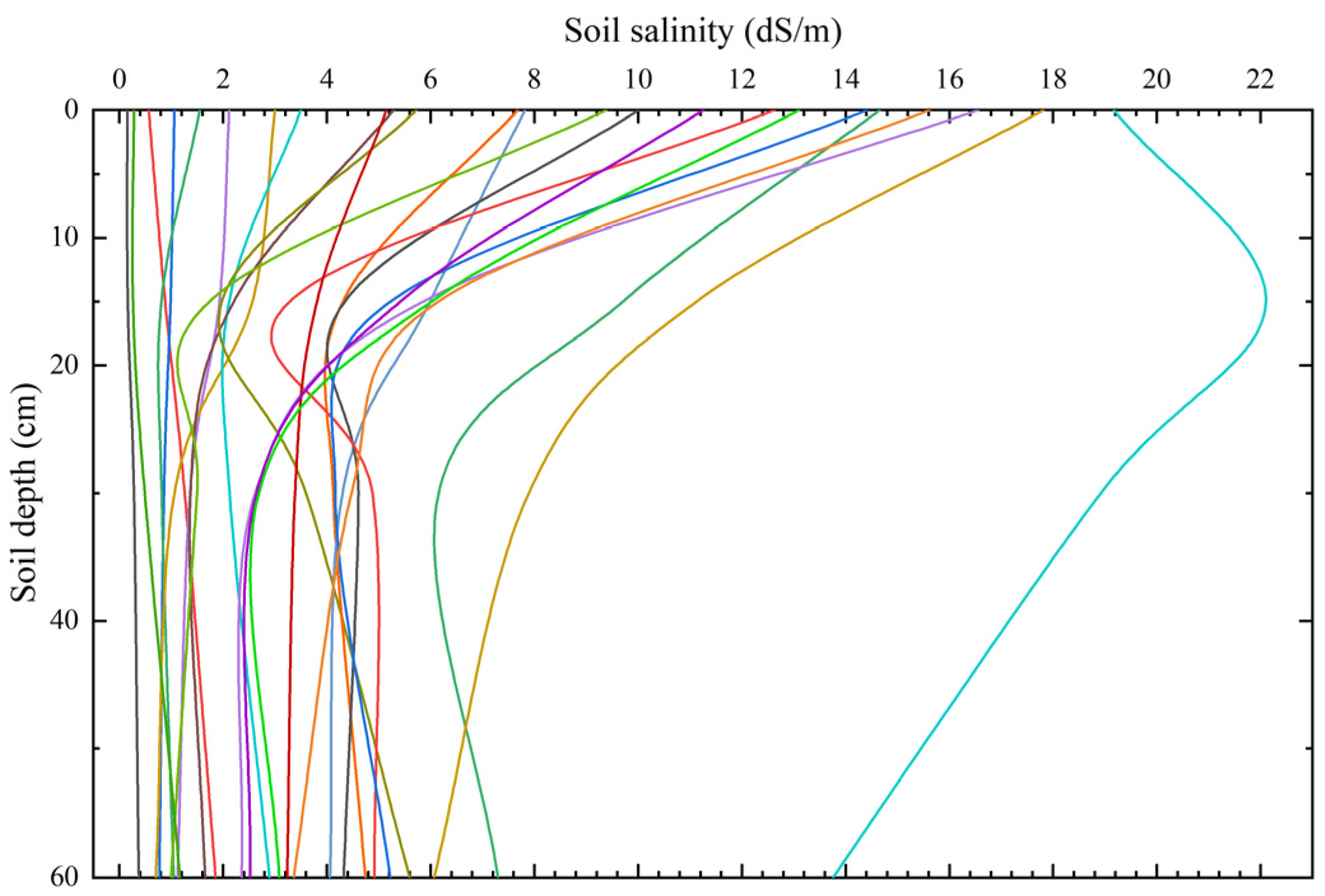
The statistical results of salinity of soil horizons at different depths in the study area were given in Table 4. The mean values of soil salinity from top to bottom were 6.084 dS/m, 2.821 dS/m, 2.231 dS/m, and 2.216 dS/m, respectively, and the soil salinity showed the characteristics of surface aggregation-type distribution. The coefficients of variation for salinity ranged from 1.099 to 1.308, all of which are intensity variations, indicating that salinity values are highly variable in the study area. Figure 3 showed the soil salinity measured at a depth of 0–60 cm, which indicated that the distribution of soil salinity at sampling points was non-uniform. The top soil exhibited higher salt levels compared to the lower layers of soil. At various depths, the changes’ magnitude varied. The 0–10 cm layer had the biggest range of change, and the range of change decreases with increasing soil layer depth. Once again, it suggested that the studied area’s soil salinity displays the surface aggregation phenomena.

3.2. Correlation Analysis and Screening of Environmental Variables

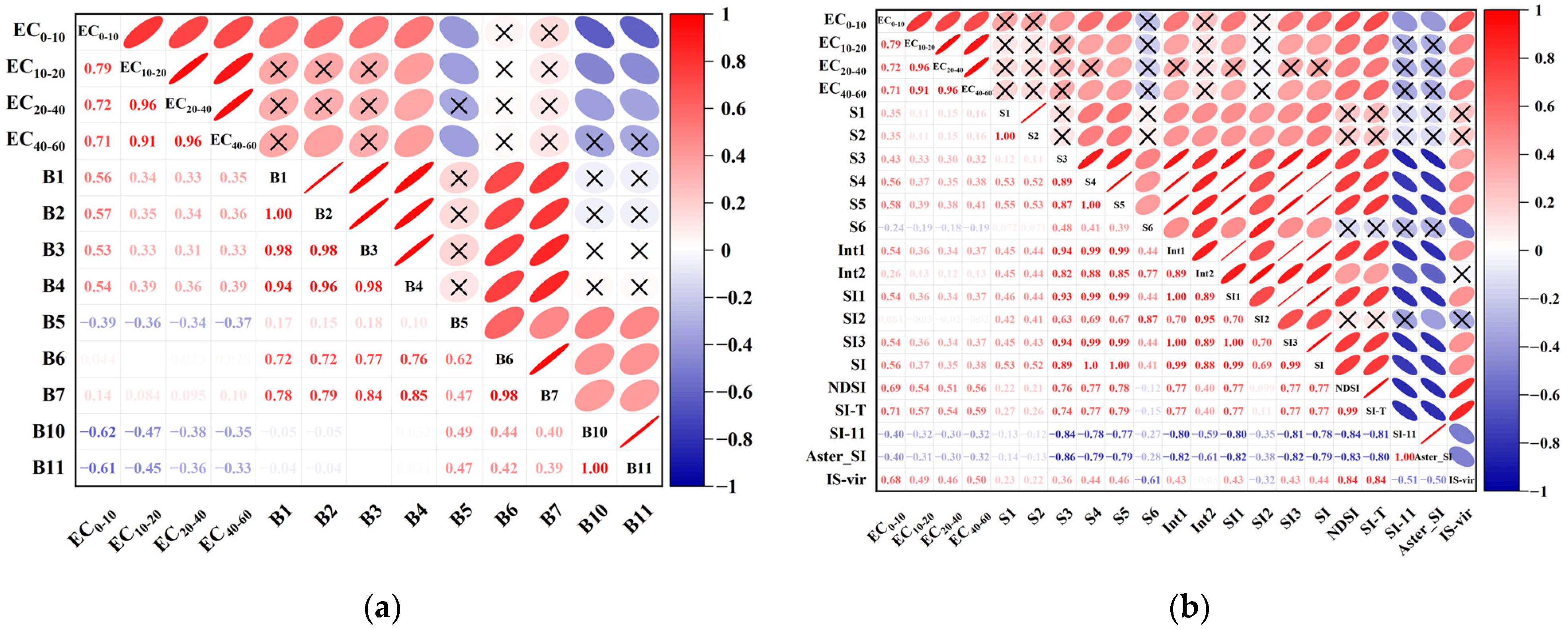
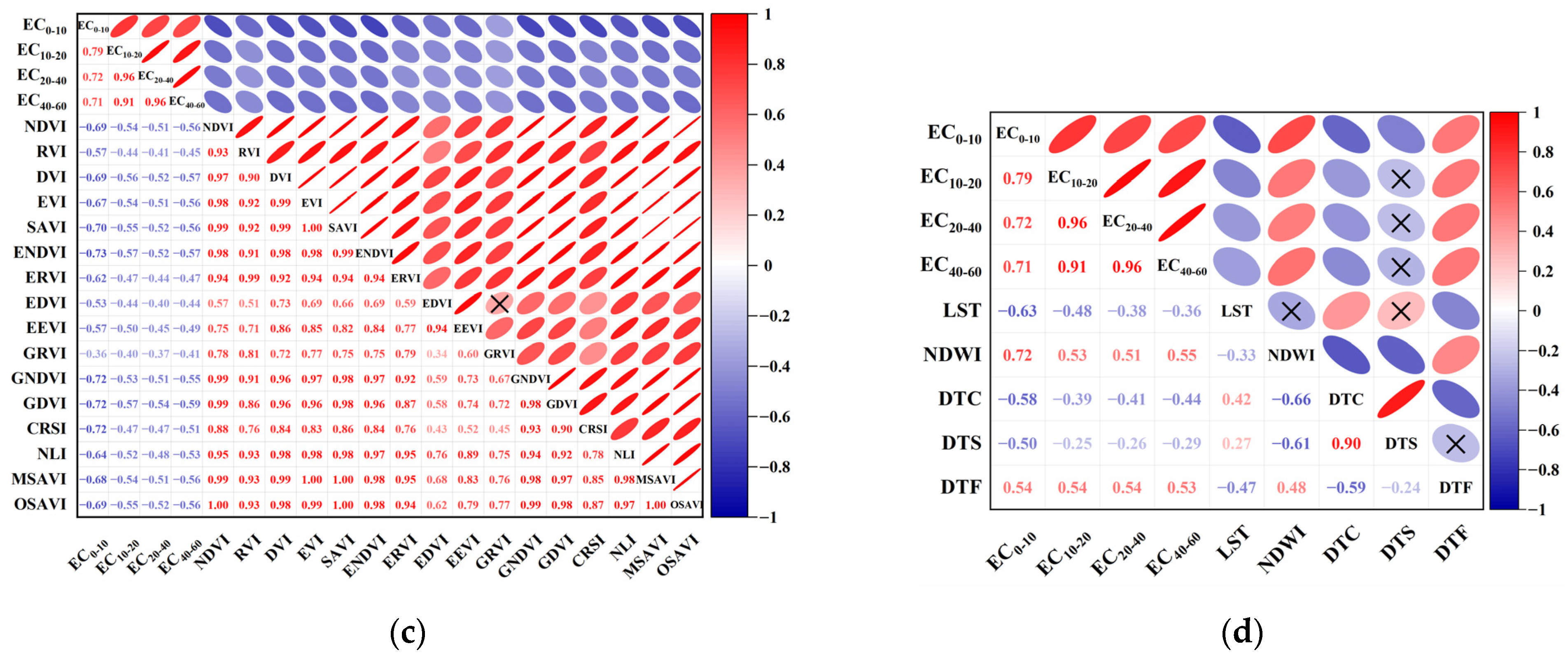
The Pearson’s correlation coefficients (Figure 4) showed that, in general, the environmental covariates were significantly correlated with the soil salinity at each depth (p < 0.01). Among the spectral values for 0–10 cm, soil salinity was significantly correlated with most of the spectral values, except with B6 and B7. The correlation between B10 and soil salinity was the strongest, with a correlation coefficient of −0.62. For 10–20 cm, the highest correlation was observed with B10 followed by B11, B4, and B5. At 20–40 cm, B4, B10, and B11 showed intermediate correlations. At 40–60 cm, B2, B4, and B5 exhibited intermediate correlations. Regarding the salinity index (Figure 4b), SI-T, NDSI, and IS-vir were significantly correlated with soil salinity at all depths. The correlation coefficients at 0–10 cm were 0.71, 0.69, and 0.68, respectively. The correlation coefficients at 10–20 cm were 0.57, 0.54, and 0.49, respectively. The correlation coefficients at 20–40 cm were 0.54, 0.51, and 0.46, respectively. The correlation coefficients at 40–60 cm were 0.59, 0.56, and 0.50, respectively. The correlation also showed a trend of first decreasing and then increasing. At all depths, the vegetation indices exhibited intermediate or strong negative correlations with soil salinity (Figure 4c). Among them, ENDVI and GDVI are most correlated with soil salinity. The correlation between ENDVI and salinity in various soil layers is −0.73, −0.57, −0.52, −0.57, respectively. The correlation between GDVI and salinity in various soil layers is −0.72, −0.57, −0.54, and −0.59, respectively. Significant negative connections were found between the heat index and soil salinity, and positive correlations were found between the moisture index and soil salinity (Figure 4d). The correlation coefficients of LST are −0.63, −0.48, −0.38, and −0.36, respectively. The correlation coefficients of NDWI are 0.72, 0.53, 0.51, and 0.55, respectively. For the spatial location index, DTC and DTF exhibited intermediate correlations (Figure 4d). DTS showed intermediate correlations at 0–10 cm and no correlations in other soil layers. DTY was positively correlated, whereas DTC and DTS were negatively correlated. In summary, it can be seen that the most sensitive indices to multi-depth soil salinity are GDVI, ENDVI, SI-T, NDWI, and LST, respectively.
In general, environmental variables related to soil salinity varied with soil depth. To cover as much soil information as possible, we selected environmental variables with coefficients greater than 0.3 (p < 0.01) as the predictive factors for subsequent analysis, and the required predictive factors for each layer are shown in Table 5. The variables in Table 5 are presented in descending order of relevance.

3.3. Simulation Accuracy and Uncertainty Using Different Algorithms

As shown in Figure 5, from the perspective of modeling effects at different depths, the three algorithms’ R2 showed a gradually decreasing trend within the depth range of 0–40 cm, while there was an upward trend within the depth range of 40–60 cm. RMSE showed a gradually decreasing trend with increasing depth. From the perspective of machine learning algorithms, RF exhibited the best modeling accuracy. Among them, the RF model located within the depth range of 0–10 cm exhibited the highest R2, with R2 values of 0.863 and 0.707 for its training and validation sets, respectively. Other RF models within the depth range also produced good results, with R2 > 0.641 in the training set and R2 > 0.534 in the validation set. In addition, in the RF model, the RMSE within the depth range of 40–60 cm reached its lowest value, with RMSE in the training set = 1.370 and RMSE in the validation set = 1.874. The RMSE at other depths was less than 3.366.
The models constructed by the above three algorithms were applied to Landsat 9 images to obtain the EC spatial distribution of each algorithm. At the same time, for comparison, kriging space interpolation of the measured EC was also performed. As shown in Figure 6, soil salinity exhibited similar spatial characteristics in the four simulation results, with higher soil salinity in coastal and especially saltern areas, while lower soil salinity was observed in the Yellow River coastal, central, and southwestern regions. The kriging interpolation was slightly deficient in predicting regions with slightly saline (4–8 dS/m), whereas the RF algorithm provided greater spatial detail. The results produced through the utilization of machine learning techniques demonstrated a higher level of spatial resolution and also revealed pronounced spatial heterogeneity.
Figure 7 presented the average and SD values of soil salinity obtained by three algorithms. The average EC values at 0–10 cm obtained using the BPNN and RF models were similar and slightly lower than those obtained using the SVM. The average soil salinity values acquired by RF were greater compared to the values obtained through the BPNN and SVM at other depths. The SD values of the RF method were the lowest among all the algorithms, with values consistently below 0.5 dS/m at all depths.

3.4. Spatial Distribution Characteristics of Soil Salinity

3.4.1. Distribution Maps of Soil Salinity

The soil EC distribution map (Figure 6 RF result) showed the distribution of soil salinity at different depths. For further analysis and visualization, in accordance with the soil salinity classification proposed by previous researchers [10,24] and taking into account the current salinity conditions of the study region, the classification methodology outlined in Table 6 was employed to categorize the levels of soil salinity depicted in the map. Figure 6 showed that the area with the salinity range of 4–8 dS/m and 8–16 dS/m accounted for the majority of the study sample area, so this study had subdivided the 4–8 dS/m and 8–16 dS/m ranges. The utilization of this classification method enabled a more comprehensive representation of the variations in soil salinity across distinct soil layers within the designated research region.
Figure 8 showed the area and percentage distribution of eight salinity levels at different depths. In the soil superficial layer (0–10 cm), soil salinization was the most serious, and the average EC was 7.107 dS/m. The area of moderately saline (8–16 dS/m) soil occupied the largest area, accounting for 49.08% of the total area. In the soil middle layer (10–20 cm and 20–40 cm), the degree of soil salinization was reduced, and the average EC was 3.327 dS/m and 2.823 dS/m, respectively. The non saline soil area was relatively large, accounting for 35.96% and 40.02%, respectively. In the soil deep layer (40–60 cm), soil salinization was relatively mild, and the average EC was 2.693 dS/m. Non-saline soil and slightly saline soil were the main type, accounting for 35.63% and 36.47%. With the increase in soil depth, the salinization of cultivated land gradually decreased.

3.4.2. Soil Salinity for Different Land-Cover Types

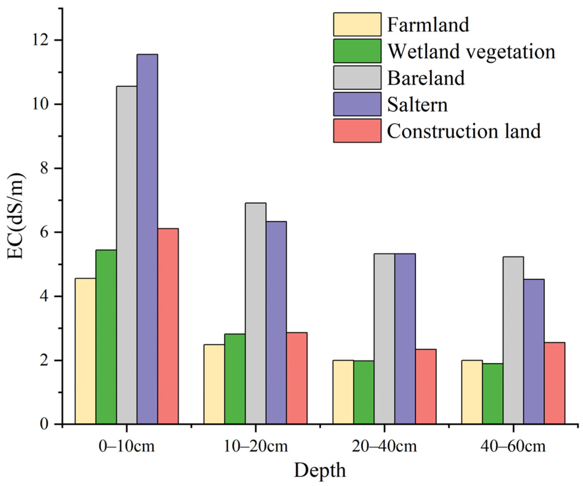
In this study, the land-cover categories included farmland, construction land, water areas, wetland vegetation, salterns, and bare land (Figure 1). Among them, salterns and bare land had the greatest soil salinity, while farmland and wetland vegetation had the least soil salinity (Figure 9). In addition, surface salinity was higher than deep salinity for all land-cover types. As the depth increased, soil salinity gradually decreased and stabilized. The difference in soil salinity between the 20–40 cm and 40–60 cm layers was not significant.

4. Discussion

4.1. Influence of Environmental Variables on Soil Salinity

To investigate the impact of different spectra and spectral indices on soil salinity, we first use correlation analysis to measure whether these spectral variables are closely related to soil salinity. As shown in Figure 4a, the sensitive bands of the surface layer (0–10 cm) are the coastal aerosol band (B1), blue band (B2), green band (B3), red band (B4), near-infrared band (B5), and thermal infrared band (B10 and B11), which is consistent with previous research results [68,69]. However, the sensitivity of the middle and bottom layers of soil to spectral bands is relatively low, which is related to the fact that remote sensing spectral information can only represent surface information. Therefore, we further used relevant spectral indices as model covariates to invert soil salinity at multiple depths.
In the study of salinity inversion in coastal plains, the salinity index is considered to be more sensitive to the response of soil salinity. Therefore, this study analyzed various salt indices and found that SI_T, NDSI, and IS_vir had the highest correlation in all soil layers and were calculated from the B3, B4, and B5 bands. These three bands had low correlation coefficients with soil salinity, probably because of the noise and atmospheric impact within the raw data. The indices obtained after combining the three bands were generally well correlated; thus, the salinity indices obtained from these three bands were closely related to soil salinity.
Different degrees of salinization can cause stress on the growth of vegetation. Therefore, soil salinity and its changing trend can be indirectly inferred through the vegetation index. Through correlation analysis, the vegetation index has a strong correlation with soil salinity in each layer. This finding is supported by Demattê et al. [70], wherein a noteworthy correlation was established between vegetation indices and deep soil parameters. The findings of our study indicate a significant negative correlation between soil salinity and all vegetation indices, suggesting that favorable vegetation conditions are typically associated with lower soil salinity. The types and distribution of vegetation communities in coastal areas are closely related to soil salinization. Salt tolerant vegetation can reduce evaporation, slow down runoff, promote water infiltration, and thus filter out salt, avoiding soil accumulation in the soil.
Based on the above two spectral indices, correlation analysis was also conducted on surface temperature and soil moisture. Overall, both LST and NDWI had a good correlation with multi-depth soil salinity. The correlation results were also consistent with the research results of Chi et al. [59]. The surface temperature is mainly controlled by soil moisture. Areas with high EC values are usually areas with high soil moisture content and low surface temperature, typically located near coastal areas and salt fields. In coastal areas, seawater intrusion is a major factor leading to the increase in soil salinity. The salt content in seawater enters the inland areas with tides. In May, as the temperature rises and precipitation decreases, evaporation increases. Such climatic conditions promote the evaporation of moisture in the soil, resulting in an increase in the concentration of surface soil salinity. At different depths, LST has the highest correlation with EC at 0–10 cm (−0.63), and the correlation gradually decreases with increasing depth. NDWI shows a high correlation with surface soil salinity (0.718). As depth increases, the correlation gradually decreases, but at 40–60 cm, the correlation increases. The reason for this phenomenon may be related to the high groundwater level in coastal areas. This discovery indicates that the distribution of water in soil plays a crucial role in influencing the spatial distribution of salinity.
Similar results were obtained in the correlation analysis of spatial location. Soil salinity was negatively correlated with DTC. With an increase in DTC, salinity decreased along the coastline to the hinterland, which again confirmed that salinity was primarily derived from the ocean. In addition, soil salinity showed a decreasing trend with a decrease in DTS and an increase in DTF, which further verified the salt accumulation effect in the salt field and the positive effect of the control measures on soil salinization in agricultural fields.
The above research results proved that the construction of characteristic spectral indices through bands can excavate the implicit information between spectral information and multi-depth soil salinity, promoting the development of deep soil salinity remote sensing inversion research.

4.2. Model Accuracy, Uncertainty, and Applicability

A model for estimating soil salinity was constructed using feature factors associated with soil salinity. The performance of each model was assessed by examining its capabilities at various depths. The RF model consistently outperformed the SVM and BPNN models and demonstrated the highest accuracy across all depths. Specifically, the R2 values for the testing sets at four soil layers were 0.707, 0.672, 0.535, and 0.534, respectively, with corresponding RMSE of 3.366, 2.747, 2.172, and 1.874 dS/m. The RF model yielded favorable results, confirming its high precision. The RF approach, which is a nonlinear estimation method, has demonstrated advantages in ecological simulations involving complex predictor variables. The results of the present study confirmed that RF models can predict not only soil surface salinity but also soil salinity at multiple depths to a high accuracy.
Regarding uncertainty validation, the SD values of the RF model were significantly lower compared to the BPNN and SVM models (Figure 7). In particular, at 40–60 cm, the RF model exhibited the lowest SD among all algorithms and depths. This suggests a relatively homogeneous distribution and minimal variation in salt content within the bottom layer, resulting in lower SD than that in the other layers. These findings confirm the low uncertainty associated with the RF model.
In terms of applicability, our model takes advantage of the convenience and continuity of remote sensing data acquisition. For instance, the open-source Landsat data offer multispectral, high-quality coverage at the global scale. and provide a more reliable data source for drawing soil salinity maps. The results acquired using machine learning showed more spatial details than those obtained through spatial interpolation and indicated notable spatial interpolation. They can help elucidate the spatial characteristics of soil salinity in the study area. Therefore, our research results contribute to vertical soil salinity mapping at various depths in coastal saline regions.
The inversion models proposed in this article are all constructed based on remote sensing data, making them more suitable for studying the spatial changes in soil salinity in coastal wetlands in different years. Nevertheless, the model described in this article may not be applicable for investigating soil salinity in seasons other than spring, as it solely relies on spring soil salinity data for research purposes. Hence, it is necessary to further study the soil salinity inversion algorithms of coastal wetlands in different seasons and explore the spatial changes in soil salinity at multiple depths in different years and seasons.

4.3. Characterization of Soil Salinity Spatial Distribution

According to the RF results in Figure 6 and Figure 8, the area of highly salinized land steadily shrank as the soil depth increased, whereas the area of mildly salinized land gradually increased (Figure 6, RF results). The decreasing trend in soil salinity from east to west gradually weakened, and the spatial distribution became more homogeneous. There were two types of soil salinity profiles: the homogeneous type was prevalent in the central and southwestern parts, while the surface aggregation type dominated the eastern part, presenting a complex characterization of the coexistence of the two profiles. The reason for this difference was that the eastern region was mainly close to the ocean, and the soil was subjected to long-term impregnation with salty water, resulting in a substantially elevated salinity level compared to other locations. Simultaneously, the low level of vegetation cover in the region cannot effectively improve the surface soil structure and provide favorable conditions for the rapid evaporation of a large amount of water. Salts are transported with the water upward through the capillary action of the soil, and ultimately accumulate in the surface layer [71].
Among the different land-cover types, farmlands had the lowest soil salinity (Figure 9). From the analysis of vertical changes, the salinity in the farmland surface was relatively high and gradually decreased with increasing profile depth. When the depth was <20 cm, the salinity tended to stabilize, and the salinity in most areas remained <2 dS/m. This might perhaps be attributed to the use of inappropriate planting and irrigation methods. Failing to adequately implement improved measures, such as salt discharge, will lead to imbalanced irrigation and drainage. Consequently, underground salt is carried to the surface with the water, leading to the salinization of cultivated land [72]. The soil salinity of the wetland vegetation area was similar to that of the farmland, indicating that some wetland plant species, namely Setaria viridis, S. salsa, Phragmites australis, and tamarix chinensis, can absorb salt from the soil [73]. Salt field and bare land were the areas with the highest soil salinity among all land-cover types, and the vertical spatial difference was large. The bare land was mostly mudflats with less vegetation coverage during ordinary times. After the evaporation of seawater, the salt crystallized on the soil surface, forming white salt spots, similarly to the salt accumulation effect of salterns [74]. This was the primary factor contributing to the exceptionally elevated levels of salt in the bare land and salterns.
In this study, EC was used as a measure to for determining soil salinity, consistent with previous academic research [55]. The average EC values at four soil layers throughout the study area were 7.107, 3.327, 2.823, and 2.693 dS/m, respectively. We employed the regression equation established by Wang et al. [75] to estimate the average soil salt content at different depths in the Kenli District of China. The estimated values for soil salt content at each depth were 16.220, 7.980, 6.882, and 6.597 g/kg, respectively. Fan et al. [76] reported the soil salinity at 0–30 cm in May 2006 to be 10.6 g/kg. The salt content at 0–30 cm as reported by Chi et al. [59] in May 2017 was 7.53 g/kg. The mean salt content within the 0–40 cm depth range in the current investigation was determined at 10.360 g/kg. These findings indicate a fluctuation in the general soil salinity within the Kenli District over the course of the past 12 years, with an initial decline and a rise after that. The observed elevation in salt concentrations within the study region can be ascribed to a multitude of contributing reasons. (1) After 2017, the construction of salt farms expanded sharply for most of Kenli District [77]. The salterns’ accumulation of salt has a substantial impact on soil salinity, resulting in notable alterations to its spatial distribution. (2) Failure to adhere to technical principles for groundwater extraction intensified seawater intrusion, leading to increased soil salinization. (3) Continuous expansion of agricultural land, using traditional planting, harvesting, and irrigation methods, resulted in poor drainage of the land during the irrigation process and a lack of optimal utilization of fertilizers, crop rotation and fallow periods, knowledge of soil testing, salinization methods, and knowledge of how to reduce salinization.
The above-mentioned natural and secondary factors have destroyed land in the Yellow River Delta. Without proper planning to prevent this, soil resources in the region will severely deteriorate in the near future, hence presenting a substantial challenge to the attainment of sustainable development goals. Therefore, the government must take appropriate measures to monitor and protect land quality and alleviate soil salinization to neutralize land degradation. While protecting and utilizing existing farmland, limiting excessive and rapid development, and advocating for ecological utilization as the main approach, existing farmland can promote straw return and mechanical deep plowing to sever soil capillaries and increase the soil’s capacity to retain water. Improving drainage systems, reasonably managing irrigation water supply and quantity, and monitoring and controlling soil salinization in a timely manner will also improve the situation. In response to the huge quantity of bare land in the research region, it is imperative to increase the screening and cultivation of salt- and alkali-tolerant plant resources in the soil, quickly improve vegetation coverage, and effectively reduce water evaporation while absorbing salt. In other regions, more nature reserves should be constructed, groundwater resources should be reasonably utilized, and land-use space should be optimized. These measures contribute to the optimal utilization of land resources and promote sustainable development in the region.

5. Conclusions

Based on measured sample data and remote sensing data, we developed a machine learning model for mapping soil salinity in multiple soil layers and assessed the variation in soil salinity at different depths in the Yellow River Delta, China. This research indicated that GDVI, ENDVI, SI-T, NDWI, and LST were considered sensitive indices for monitoring soil salinity at multiple depths. RF model demonstrated higher precision, lower uncertainty, and better applicability than other machine learning models. Vegetation indexes were identified as a crucial determinant influencing soil salinity. The soil salinity profiles in the research area showed a complex coexistence of surface aggregated and homogeneous salinity. On the horizontal scale, the overall spatial characteristics of soil salinity at the four depth ranges were similar, with a decreasing trend from east to west along the coastline. Among the different land-cover types, the salinity of the soil was greatest in salterns and bare land, while it was lowest in wetland vegetation and agricultural land.
This study developed soil salinity inversion models for different soil layers using only remote sensing data, which can improve the efficiency of comprehensive saline alkali land management and contribute to achieving the goal of land degradation neutrality.

Author Contributions

Conceptualization, H.Z. (Haoran Zhang) and X.F.; methodology, H.Z. (Haoran Zhang) and X.F.; software, H.Z. (Haoran Zhang), X.F., Y.Z. and H.Z. (Hengcai Zhang); validation, H.Z. (Haoran Zhang), Z.Q. and X.F.; investigation, H.Z. (Haoran Zhang), Z.Q., X.F. and Z.X.; resources, X.F., Y.Z., H.Z. (Hengcai Zhang) and Z.X.; data curation, H.Z. (Haoran Zhang), Y.Z., Z.Q. and X.F.; writing—original draft preparation, H.Z. (Haoran Zhang), X.F. and Z.Q.; writing—review and editing, H.Z. (Haoran Zhang), X.F., Y.Z., H.Z. (Hengcai Zhang), Z.Q. and Z.X.; visualization, H.Z. (Haoran Zhang) and X.F.; supervision, X.F. and Z.X.; project administration, X.F. funding acquisition, X.F. All authors have read and agreed to the published version of the manuscript.

Funding

This research was supported by Shandong Provincial Natural Science Foundation (ZR2022MD059), Zhongke Shandong Dongying Institute of Geographic Sciences Open Fund (202101) and National Natural Science Foundation of China (41701521).

Data Availability Statement

Data are contained within the artice.

Conflicts of Interest

The authors declare no conflict of interest.

References

  1. Abbas, A.; Khan, S.; Hussain, N.; Hanjra, M.A.; Akbar, S. Characterizing soil salinity in irrigated agriculture using a remote sensing approach. Phys. Chem. Earth 2013, 55–57, 43–52. [Google Scholar] [CrossRef]
  2. Alqasemi, A.S.; Ibrahim, M.; Al-Quraishi, A.M.F.; Saibi, H.; Al-Fugara, A.K.; Kaplan, G. Detection and modeling of soil salinity variations in arid lands using remote sensing data. Open Geosci. 2021, 13, 443–453. [Google Scholar] [CrossRef]
  3. Bergstad, M.; Or, D.; Withers, P.J.; Shokri, N. Evaporation Dynamics and NaCl Precipitation on Capillarity-Coupled Heterogeneous Porous Surfaces. Water Resour. Res. 2018, 54, 3876–3885. [Google Scholar] [CrossRef]
  4. Li, J.; Chen, H.; Guo, K.; Li, W.; Feng, X.; Liu, X. Changes in soil properties induced by pioneer vegetation patches in coastal ecosystem. CATENA 2021, 204, 105393. [Google Scholar] [CrossRef]
  5. Fan, X.; Pedroli, B.; Liu, G.; Liu, Q.; Liu, H.; Shu, L. Soil salinity development in the yellow river delta in relation to groundwater dynamics. Land Degrad. Dev. 2012, 23, 175–189. [Google Scholar] [CrossRef]
  6. Zhang, T.T.; Zeng, S.L.; Gao, Y.; Ouyang, Z.T.; Li, B.; Fang, C.M.; Zhao, B. Assessing impact of land uses on land salinization in the Yellow River Delta, China using an integrated and spatial statistical model. Land Use Policy 2011, 28, 857–866. [Google Scholar] [CrossRef]
  7. Nachshon, U. Cropland Soil Salinization and Associated Hydrology: Trends, Processes and Examples. Water 2018, 10, 1030. [Google Scholar] [CrossRef]
  8. Salcedo, F.P.; Cutillas, P.P.; Cabañero, J.J.A.; Vivaldi, A.G. Use of remote sensing to evaluate the effects of environmental factors on soil salinity in a semi-arid area. Sci. Total Environ. 2022, 815, 152524. [Google Scholar] [CrossRef]
  9. Amezketa, E. An integrated methodology for assessing soil salinization, a pre-condition for land desertification. J. Arid Environ. 2006, 67, 594–606. [Google Scholar] [CrossRef]
  10. Wang, J.; Peng, J.; Li, H.; Yin, C.; Liu, W.; Wang, T.; Zhang, H. Soil salinity mapping using machine learning algorithms with the Sentinel-2 MSI in arid areas, China. Remote Sens. 2021, 13, 305. [Google Scholar] [CrossRef]
  11. Li, H.Y.; Shi, Z.; Webster, R.; Triantafilis, J. Mapping the three-dimensional variation of soil salinity in a rice-paddy soil. Geoderma 2013, 195–196, 31–41. [Google Scholar] [CrossRef]
  12. Samiee, M.; Ghazavi, R.; Pakparvar, M.; Vali, A. Mapping spatial variability of soil salinity in a coastal area located in an arid environment using geostatistical and correlation methods based on the satellite data. Desert 2018, 23, 233–242. [Google Scholar] [CrossRef]
  13. Wang, Y.; Deng, C.; Liu, Y.; Niu, Z.; Li, Y. Identifying change in spatial accumulation of soil salinity in an inland river watershed, China. Sci. Total Environ. 2018, 621, 177–185. [Google Scholar] [CrossRef]
  14. Gorji, T.; Sertel, E.; Tanik, A. Monitoring soil salinity via remote sensing technology under data scarce conditions: A case study from Turkey. Ecol. Indic. 2017, 74, 384–391. [Google Scholar] [CrossRef]
  15. Li, Y.; Chang, C.; Wang, Z.; Zhao, G. Remote sensing prediction and characteristic analysis of cultivated land salinization in different seasons and multiple soil layers in the coastal area. Int. J. Appl. Earth Obs. Geoinf. 2022, 111, 102838. [Google Scholar] [CrossRef]
  16. Zovko, M.; Romić, D.; Colombo, C.; Di Iorio, E.; Romić, M.; Buttafuoco, G.; Castrignanò, A. A geostatistical Vis-NIR spectroscopy index to assess the incipient soil salinization in the Neretva River valley, Croatia. Geoderma 2018, 332, 60–72. [Google Scholar] [CrossRef]
  17. Asfaw, E.; Suryabhagavan, K.V.; Argaw, M. Soil salinity modeling and mapping using remote sensing and GIS: The case of Wonji sugar cane irrigation farm, Ethiopia. J. Saudi Soc. Agric. Sci. 2018, 17, 250–258. [Google Scholar] [CrossRef]
  18. Wang, J.; Ding, J.; Yu, D.; Ma, X.; Zhang, Z.; Ge, X.; Teng, D.; Li, X.; Liang, J.; Lizag, I.; et al. Capability of Sentinel-2 MSI data for monitoring and mapping of soil salinity in dry and wet seasons in the Ebinur Lake region, Xinjiang, China. Geoderma 2019, 353, 172–187. [Google Scholar] [CrossRef]
  19. Sahbeni, G.; Ngabire, M.; Musyimi, P.K.; Székely, B. Challenges and Opportunities in Remote Sensing for Soil Salinization Mapping and Monitoring: A Review. Remote Sens. 2023, 15, 2540. [Google Scholar] [CrossRef]
  20. Pradipta, A.; Soupios, P.; Kourgialas, N.; Doula, M.; Dokou, Z.; Makkawi, M.; Alfarhan, M.; Tawabini, B.; Kirmizakis, P.; Yassin, M. Remote Sensing, Geophysics, and Modeling to Support Precision Agriculture&mdash;Part 1: Soil Applications. Water 2022, 14, 1158. [Google Scholar] [CrossRef]
  21. Zeraatpisheh, M.; Ayoubi, S.; Jafari, A.; Tajik, S.; Finke, P. Digital mapping of soil properties using multiple machine learning in a semi-arid region, central Iran. Geoderma 2019, 338, 445–452. [Google Scholar] [CrossRef]
  22. Vermeulen, D.; Van Niekerk, A. Machine learning performance for predicting soil salinity using different combinations of geomorphometric covariates. Geoderma 2017, 299, 1–12. [Google Scholar] [CrossRef]
  23. Bokde, N.D.; Ali, Z.H.; Al-Hadidi, M.T.; Farooque, A.A.; Jamei, M.; Maliki, A.A.A.; Beyaztas, B.H.; Faris, H.; Yaseen, Z.M. Total Dissolved Salt Prediction Using Neurocomputing Models: Case Study of Gypsum Soil Within Iraq Region. IEEE Access 2021, 9, 53617–53635. [Google Scholar] [CrossRef]
  24. Mohamed, S.A.; Metwaly, M.M.; Metwalli, M.R.; AbdelRahman, M.A.E.; Badreldin, N. Integrating Active and Passive Remote Sensing Data for Mapping Soil Salinity Using Machine Learning and Feature Selection Approaches in Arid Regions. Remote Sens. 2023, 15, 1751. [Google Scholar] [CrossRef]
  25. Farifteh, J.; Van der Meer, F.; Atzberger, C.; Carranza, E.J.M. Quantitative analysis of salt-affected soil reflectance spectra: A comparison of two adaptive methods (PLSR and ANN). Remote Sens. Environ. 2007, 110, 59–78. [Google Scholar] [CrossRef]
  26. Ma, G.; Ding, J.; Han, L.; Zhang, Z.; Ran, S. Digital mapping of soil salinization based on Sentinel-1 and Sentinel-2 data combined with machine learning algorithms. Reg. Sustain. 2021, 2, 177–188. [Google Scholar] [CrossRef]
  27. Golestani, M.; Mosleh Ghahfarokhi, Z.; Esfandiarpour-Boroujeni, I.; Shirani, H. Evaluating the spatiotemporal variations of soil salinity in Sirjan Playa, Iran using Sentinel-2A and Landsat-8 OLI imagery. CATENA 2023, 231, 107375. [Google Scholar] [CrossRef]
  28. Chi, Y.; Shi, H.; Zheng, W.; Sun, J. Simulating spatial distribution of coastal soil carbon content using a comprehensive land surface factor system based on remote sensing. Sci. Total Environ. 2018, 628–629, 384–399. [Google Scholar] [CrossRef]
  29. Zhang, S.; Tian, J.; Lu, X.; Tian, Q. Temporal and spatial dynamics distribution of organic carbon content of surface soil in coastal wetlands of Yancheng, China from 2000 to 2022 based on Landsat images. CATENA 2023, 223, 106961. [Google Scholar] [CrossRef]
  30. Guo, B.; Yang, X.; Yang, M.; Sun, D.; Zhu, W.; Zhu, D.; Wang, J. Mapping soil salinity using a combination of vegetation index time series and single-temporal remote sensing images in the Yellow River Delta, China. CATENA 2023, 231, 107313. [Google Scholar] [CrossRef]
  31. Li, Y.; Chang, C.; Wang, Z.; Zhao, G. Upscaling remote sensing inversion and dynamic monitoring of soil salinization in the Yellow River Delta, China. Ecol. Indic. 2023, 148, 110087. [Google Scholar] [CrossRef]
  32. Wu, Y.; Liu, G.; Yang, J.; Yu, S. Spatial variability of soil salinity based on multi-source data for typical zone of flood area of the Yellow river in central China. Trans. Chin. Soc. Agric. Eng. 2015, 31, 115–120. [Google Scholar] [CrossRef]
  33. Yang, N.; Cui, W.; Zhang, Z.; Zhang, J.; Chen, J.; Du, R.; Lao, C.; Zhou, Y. Soil salinity inversion at different depths using improved spectral index with UAV multispectral remote sensing. Trans. Chin. Soc. Agric. Eng. 2020, 36, 13–21. [Google Scholar] [CrossRef]
  34. Cui, J.; Chen, X.; Han, W.; Cui, X.; Ma, W.; Li, G. Estimation of Soil Salt Content at Different Depths Using UAV Multi-Spectral Remote Sensing Combined with Machine Learning Algorithms. Remote Sens. 2023, 15, 5254. [Google Scholar] [CrossRef]
  35. Alves, A.C.; de Souza, E.R.; de Melo, H.F.; Oliveira Pinto, J.G.; de Andrade Rego Junior, F.E.; de Souza Júnior, V.S.; Adriano Marques, F.; do Santos, M.A.; Schaffer, B.; Raj Gheyi, H. Comparison of solution extraction methods for estimating electrical conductivity in soils with contrasting mineralogical assemblages and textures. CATENA 2022, 218, 106581. [Google Scholar] [CrossRef]
  36. Eldeiry, A.A.; Garcia, L.A. Detecting Soil Salinity in Alfalfa Fields using Spatial Modeling and Remote Sensing. Soil Sci. Soc. Am. J. 2008, 72, 201–211. [Google Scholar] [CrossRef]
  37. Abbas, A.; Khan, S. Using remote sensing techniques for appraisal of irrigated soil salinity. In Proceedings of the International Congress on Modelling and Simulation (MODSIM), Christenchurch, New Zealand, 10–13 December 2007; pp. 2632–2638. [Google Scholar]
  38. Douaoui, A.E.K.; Nicolas, H.; Walter, C. Detecting salinity hazards within a semiarid context by means of combining soil and remote-sensing data. Geoderma 2006, 134, 217–230. [Google Scholar] [CrossRef]
  39. Khan, N.M.; Rastoskuev, V.V.; Shalina, E.V.; Sato, Y. Mapping salt-affected soils using remote sensing indicators—A simple approach with the use of GIS IDRISI. In Proceedings of the 22nd Asian Conference on Remote Sensing, Singapore, 5–9 November 2001; p. 9. [Google Scholar]
  40. Tripathi, N.; Rai, B.K.; Dwivedi, P. Spatial modeling of soil alkalinity in GIS environment using IRS data. In Proceedings of the 18th Asian Conference on Remote Sensing, ACRS, Kuala Lumpur, Malaysia, 20–24 October 1997; pp. 20–24. [Google Scholar]
  41. Fourati, H.T.; Bouaziz, M.; Benzina, M.; Bouaziz, S. Modeling of soil salinity within a semi-arid region using spectral analysis. Arab. J. Geosci. 2015, 8, 11175–11182. [Google Scholar] [CrossRef]
  42. Song, C.; Ren, H.; Huang, C. Estimating Soil Salinity in the Yellow River Delta, Eastern China-An Integrated Approach Using Spectral and Terrain Indices with the Generalized Additive Model. Pedosphere 2016, 26, 626–635. [Google Scholar] [CrossRef]
  43. Gitelson, A.A.; Kaufman, Y.J.; Merzlyak, M.N. Use of a green channel in remote sensing of global vegetation from EOS-MODIS. Remote Sens. Environ. 1996, 58, 289–298. [Google Scholar] [CrossRef]
  44. Baret, F.; Guyot, G. Potentials and limits of vegetation indices for LAI and APAR assessment. Remote Sens. Environ. 1991, 35, 161–173. [Google Scholar] [CrossRef]
  45. Clevers, J.G.P.W. The derivation of a simplified reflectance model for the estimation of leaf area index. Remote Sens. Environ. 1988, 25, 53–69. [Google Scholar] [CrossRef]
  46. Scudiero, E.; Skaggs, T.H.; Corwin, D.L. Regional scale soil salinity evaluation using Landsat 7, western San Joaquin Valley, California, USA. Geoderma Reg. 2014, 2–3, 82–90. [Google Scholar] [CrossRef]
  47. Huete, A.R. A soil-adjusted vegetation index (SAVI). Remote Sens. Environ. 1988, 25, 295–309. [Google Scholar] [CrossRef]
  48. Chen, H.; Zhao, G.; Chen, J.; Wang, R.; Gao, M. Remote sensing inversion of saline soil salinity based on modified vegetation index in estuary area of Yellow River. Trans. Chin. Soc. Agric. Eng. 2015, 31, 107–114. [Google Scholar] [CrossRef]
  49. Farwell, L.S.; Gudex-Cross, D.; Anise, I.E.; Bosch, M.J.; Olah, A.M.; Radeloff, V.C.; Razenkova, E.; Rogova, N.; Silveira, E.M.O.; Smith, M.M.; et al. Satellite image texture captures vegetation heterogeneity and explains patterns of bird richness. Remote Sens. Environ. 2021, 253, 112175. [Google Scholar] [CrossRef]
  50. Wu, W.; Al-Shafie, W.M.; Mhaimeed, A.S.; Ziadat, F.; Nangia, V.; Payne, W.B. Soil Salinity Mapping by Multiscale Remote Sensing in Mesopotamia, Iraq. IEEE J. Sel. Top. Appl. Earth Obs. Remote Sens. 2014, 7, 4442–4452. [Google Scholar] [CrossRef]
  51. Goel, N.S.; Qin, W. Influences of canopy architecture on relationships between various vegetation indices and LAI and Fpar: A computer simulation. Remote Sen. Rev. 1994, 10, 309–347. [Google Scholar] [CrossRef]
  52. Qi, J.G.; Chehbouni, A.R.; Huete, A.R.; Kerr, Y.H.; Sorooshian, S. A modified soil adjusted vegetation index. Remote Sens. Environ. 1994, 48, 119–126. [Google Scholar] [CrossRef]
  53. Qin, Z.; Zhang, M.; Karnieli, A.; Berliner, P. Mono-window algorithm for retrieving land surface temperature from Landsat TM6 data. Acta Geogr. Sin. 2001, 56, 456–466. [Google Scholar]
  54. Gu, Y.; Brown, J.F.; Verdin, J.P.; Wardlow, B. A five-year analysis of MODIS NDVI and NDWI for grassland drought assessment over the central Great Plains of the United States. Geophys. Res. Lett. 2007, 34, L06407. [Google Scholar] [CrossRef]
  55. Yu, J.; Li, Y.; Han, G.; Zhou, D.; Fu, Y.; Guan, B.; Wang, G.; Ning, K.; Wu, H.; Wang, J. The spatial distribution characteristics of soil salinity in coastal zone of the Yellow River Delta. Environ. Earth Sci. 2014, 72, 589–599. [Google Scholar] [CrossRef]
  56. Hamed, Y. Soil structure and salinity effects of fish farming as compared to traditional farming in northeastern Egypt. Land Use Policy 2008, 25, 301–308. [Google Scholar] [CrossRef]
  57. Li, Y.; Dongye, G.; Li, X. Countermeasure on sustainable utilization of saline soil in Yellow River Delta. J. Soil Water Conserv. 2003, 17, 55–62. [Google Scholar] [CrossRef]
  58. Wang, N.; Xue, J.; Peng, J.; Biswas, A.; He, Y.; Shi, Z. Integrating Remote Sensing and Landscape Characteristics to Estimate Soil Salinity Using Machine Learning Methods: A Case Study from Southern Xinjiang, China. Remote Sens. 2020, 12, 4118. [Google Scholar] [CrossRef]
  59. Chi, Y.; Sun, J.; Liu, W.; Wang, J.; Zhao, M. Mapping coastal wetland soil salinity in different seasons using an improved comprehensive land surface factor system. Ecol. Indic. 2019, 107, 105517. [Google Scholar] [CrossRef]
  60. Kaplan, G.; Gašparović, M.; Alqasemi, A.S.; Aldhaheri, A.; Abuelgasim, A.; Ibrahim, M. Soil salinity prediction using Machine Learning and Sentinel—2 Remote Sensing Data in Hyper—Arid areas. Phys. Chem. Earth Parts A/B/C 2023, 130, 103400. [Google Scholar] [CrossRef]
  61. Yang, H.; Wang, Z.; Cao, J.; Wu, Q.; Zhang, B. Estimating soil salinity using Gaofen-2 imagery: A novel application of combined spectral and textural features. Environ. Res. 2023, 217, 114870. [Google Scholar] [CrossRef]
  62. Rumelhart, D.E.; Hinton, G.E.; Williams, R.J. Learning Representations by Back Propagating Errors. Nature 1986, 323, 533–536. [Google Scholar] [CrossRef]
  63. Wang, X.; Zhang, F.; Ding, J.; Kung, H.-T.; Latif, A.; Johnson, V.C. Estimation of soil salt content (SSC) in the Ebinur Lake Wetland National Nature Reserve (ELWNNR), Northwest China, based on a Bootstrap-BP neural network model and optimal spectral indices. Sci. Total Environ. 2018, 615, 918–930. [Google Scholar] [CrossRef]
  64. Vapnik, V. The Nature of Statistical Learning Theory; Springer Science & Business Media: Berlin/Heidelberg, Germany, 1995. [Google Scholar]
  65. Breiman, L. Random forests. Mach. Learn. 2001, 45, 5–32. [Google Scholar] [CrossRef]
  66. Liu, D.; Fan, Z.; Fu, Q.; Li, M.; Faiz, M.A.; Ali, S.; Li, T.; Zhang, L.; Khan, M.I. Random forest regression evaluation model of regional flood disaster resilience based on the whale optimization algorithm. J. Clean. Prod. 2020, 250, 119468. [Google Scholar] [CrossRef]
  67. Wang, F.; Yang, S.; Wei, Y.; Shi, Q.; Ding, J. Characterizing soil salinity at multiple depth using electromagnetic induction and remote sensing data with random forests: A case study in Tarim River Basin of southern Xinjiang, China. Sci. Total Environ. 2021, 754, 142030. [Google Scholar] [CrossRef] [PubMed]
  68. Xie, L.; Feng, X.; Zhang, C.; Dong, Y.; Huang, J.; Cheng, J. A Framework for Soil Salinity Monitoring in Coastal Wetland Reclamation Areas Based on Combined Unmanned Aerial Vehicle (UAV) Data and Satellite Data. Drones 2022, 6, 257. [Google Scholar] [CrossRef]
  69. Dong, T.; Liu, J.; Shang, J.; Qian, B.; Ma, B.; Kovacs, J.M.; Walters, D.; Jiao, X.; Geng, X.; Shi, Y. Assessment of red-edge vegetation indices for crop leaf area index estimation. Remote Sens. Environ. 2019, 222, 133–143. [Google Scholar] [CrossRef]
  70. Demattê, J.A.M.; Sayão, V.M.; Rizzo, R.; Fongaro, C.T. Soil class and attribute dynamics and their relationship with natural vegetation based on satellite remote sensing. Geoderma 2017, 302, 39–51. [Google Scholar] [CrossRef]
  71. Yang, J.; Yao, R. Spatial variability of soil water and salt characteristics in the Yellow River Delta. Sci. Geogr. Sin. 2007, 27, 348–353. [Google Scholar]
  72. Silatsa, F.B.T.; Kebede, F. A quarter century experience in soil salinity mapping and its contribution to sustainable soil management and food security in Morocco. Geoderma Reg. 2023, 34, e00695. [Google Scholar] [CrossRef]
  73. Sun, J.; Xia, J.; Zhao, X.; Gao, F.; Zhao, W.; Xing, X.; Dong, M.; Chu, J. Enrichment of soil nutrients and salt ions with different salinities under Tamarix chinensis shrubs in the Yellow River Delta. CATENA 2023, 232, 107433. [Google Scholar] [CrossRef]
  74. Han, L.; Liu, D.; Cheng, G.; Zhang, G.; Wang, L. Spatial distribution and genesis of salt on the saline playa at Qehan Lake, Inner Mongolia, China. Catena 2019, 177, 22–30. [Google Scholar] [CrossRef]
  75. Wang, Z.; Zhao, G.; Gao, M.; Chang, C. Spatial variability of soil salinity in coastal saline soil at different scales in the Yellow River Delta, China. Environ. Monit. Assess. 2017, 189, 80. [Google Scholar] [CrossRef] [PubMed]
  76. Fan, X.; Liu, G.; Liu, H. Evaluating the spatial distribution of soil salinity in the Yellow river delta based on Kriging and Cokriging Methods. Resour. Sci. 2014, 36, 0321–0327. [Google Scholar]
  77. Chi, Y.; Shi, H.; Zheng, W.; Sun, J.; Fu, Z. Spatiotemporal characteristics and ecological effects of the human interference index of the Yellow River Delta in the last 30 years. Ecol. Indic. 2018, 89, 880–892. [Google Scholar] [CrossRef]
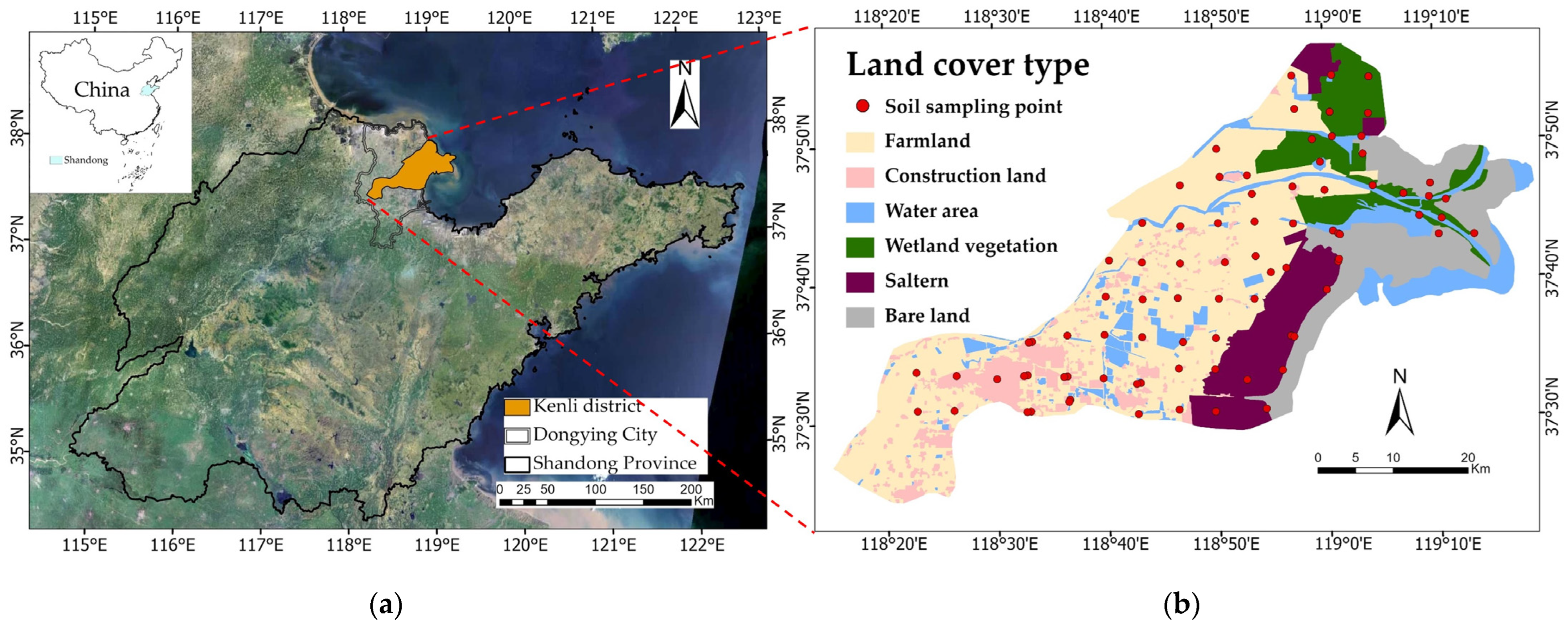
Figure 1. Study area and sampling points: (a) China; Shandong Province; (b) Kenli district and schematic diagram of land-cover types.
Remotesensing 15 05640 g001
Figure 2. The workflow of this study.
Remotesensing 15 05640 g002
Figure 3. Soil salinity profile map of representative sample with depth of 0–60 cm (different color lines represent different sampling points).
Remotesensing 15 05640 g003
Figure 4. Correlation between soil electrical conductivity and (a) spectral index, (b) salinity index, (c) vegetation index, and (d) Heat and moisture indices and spatial location (the orientation of the ellipses is indicative of the positive and negative associations, and the presence of a cross denotes statistical significance at a level of p < 0.01).
Remotesensing 15 05640 g004aRemotesensing 15 05640 g004b
Figure 5. Simulation accuracy using different algorithms: (a) R2 and (b) root mean square error (RMSE). BPNN, back propagation neural network; SVM, support vector machine; RF, random forest.
Remotesensing 15 05640 g005
Figure 6. Maps of soil salinity using different algorithms. BPNN, back propagation neural network; SVM, support vector machine; RF, random forest; Kriging interpolation.
Remotesensing 15 05640 g006
Figure 7. Mean values and standard deviations of soil EC in the entire study area using different algorithms. EC, electrical conductivity; ME, mean value of soil EC; MSD, mean standard deviation of soil EC; BPNN, back propagation neural network; SVM, support vector machine; RF, random forest.
Remotesensing 15 05640 g007
Figure 8. Percentage of area occupied by different soil salinity categories at different depths.
Remotesensing 15 05640 g008
Figure 9. Soil salinity in different land-cover types based on random forest results.
Remotesensing 15 05640 g009
Table 1. Salinity indices and formulas used in this research.
Salinity IndexFormulaReference
S1B/R[37]
S2(B − R)/(B + R)
S3(G × R)/B
S4(B × R)0.5
S5(B × R)/G
S6(R × NIR)/G
Int1(G + R)/2[38]
Int2(G + R + NIR)/2
SI1(G × R)0.5
SI2[(G)2 + (R)2 + (NIR)2]0.5
SI3[(R)2 + (G)2]0.5
SI(B × R)0.5[39]
NDSI(R − NIR)/(R + NIR)
SI-T(R/NIR) × 100[40]
SI-11SWIR1/SWIR2[41]
Aster-SI(SWIR1 − SWIR2)/(SWIR1 + SWIR2)
IS-vir2 × G − (R + NIR)
Table 2. Vegetation indices and formulas used in this research.
Vegetation IndexFormulaReference
NDVI(NIR − R)/(NIR + R)[43]
RVINIR/R[44]
DVINIR − R[45]
EVI2.5 × (NIR − R)/(NIR + 6 × R − 7.5 × B + 1)[46]
SAVI1.5((NIR − R)/(NIR + R + 0.5))[47]
ENDVI(NIR + SWIR 2 − R)/(NIR + SWIR 2 + R)[48]
ERVI(NIR + SWIR 2)/R
EDVINIR + SWIR 1 − R
EEVI2.5 × (NIR + SWIR 1 − R)/(NIR+ SWIR 1 + 6 × R − 7.5 × B + 1)
GRVI(G − R)/(G + R)[49]
GNDVI(NIR − G)/(NIR + G)[43]
GDVI(NIR2 − R2)/(NIR2 + R2)[50]
CRSI((NIR × R − G × B)/(NIR × R + G × B))0.5[30]
NLI(NIR2 − R)/(NIR2 + R)[51]
MSAVI(2NIR + 1 − ((2NIR + 1) 2 − 8 (NIR − R))0.5)/2[52]
OSAVI(1 + 0.16) (NIR − R)/(NIR + R + 0.16)
Table 3. Main hyperparameters of the different models.
Soil Depths (cm)BPNNSVMRF
0–10Number of hidden layers = 2; Number of neurons = 13, 9; Activation functions = tanh, tanhc = 1; g = 0.0625minleaf = 5; ntree = 500
10–20Number of hidden layers = 1; Number of neurons = 12; Activation functions = logisticc = 1; g = 0.0625minleaf = 4; ntree = 300
20–40Number of hidden layers = 1; Number of neurons = 9; Activation functions = logisticc = 0.3536; g = 0.0625minleaf = 4; ntree = 300
40–60Number of hidden layers = 2; Number of neurons = 16, 8; Activation functions = tanh, tanhc = 1; g = 0.0625minleaf = 4; ntree = 200
Table 4. Descriptive statistics of EC (dS/m).
Soil Depths (cm)Sample NumberMinMaxAverageMedianSDCV
0–10890.154 19.170 6.084 3.330 5.917 0.973
10–20890.149 22.100 2.821 1.633 3.734 1.324
20–40890.169 18.920 2.231 1.366 2.988 1.339
40–60890.120 13.760 2.216 1.248 2.418 1.091
Table 5. Multi-depth soil salinity predictive factor system based on remote sensing.
Soil Depths (cm)TypePredictive Factors
0–10Spectral valueB10, B11, B2, B1, B4, B3, B5
Salinity indexSI-T, NDSI, IS-vir, S5, S4, SI, Int1, SI1, SI3, S3, SI-11, Aster_SI
Vegetation indexENDVI, CRSI, GNDVI, GDVI, SAVI, DVI, OSAVI, NDVI, MSAVI, EVI, NLI, ERVI, RVI, EEVI, EDVI, GRVI
Heat and moisture indexNDWI, LST
Spatial locationDTC, DTF, DTS
10–20Spectral valueB10, B11, B4, B5
Salinity indexSI-T, NDSI, IS-vir, S5, S4, SI, SI3, Int1, SI1
Vegetation indexGDVI, ENDVI, DVI, SAVI, OSAVI, EVI, MSAVI, NDVI, GNDVI, NLI, EEVI, ERVI, CRSI, EDVI, RVI, GRVI
Heat and moisture indexNDWI, LST
Spatial locationDTF, DTC
20–40Spectral valueB10, B11, B4
Salinity indexSI-T, NDSI, IS-vir, S5
Vegetation indexGDVI, ENDVI, DVI, SAVI, OSAVI, NDVI, EVI, MSAVI, GNDVI, NLI, CRSI, EEVI, EVI, RVI, EDVI, GRVI
Heat and moisture indexNDWI, LST
Spatial locationDTF, DTC
40–60Spectral valueB4, B5, B2
Salinity indexSI-T, NDSI, IS-vir, S5, S4, SI, SI3, Int1, SI1
Vegetation indexGDVI, DVI, ENDVI, SAVI, OSAVI, EVI, MSAVI, NDVI, GNDVI, NLI, CRSI, EEVI, ERVI, RVI, EDVI, GRVI
Heat and moisture indexNDWI, LST
Spatial locationDTF, DTC
Table 6. Soil salinity classification and crop growth based on EC.
Salinity ClassSoil Salinity (dS/m)Soil Salinity Levels
1<2non-saline
22–4very slightly saline
34–6slightly saline
46–8
58–10moderately saline
610–12
712–16
8>16strongly saline
Disclaimer/Publisher’s Note: The statements, opinions and data contained in all publications are solely those of the individual author(s) and contributor(s) and not of MDPI and/or the editor(s). MDPI and/or the editor(s) disclaim responsibility for any injury to people or property resulting from any ideas, methods, instructions or products referred to in the content.