

Satellite Lidar Measurements as a Critical New Global Ocean Climate Record
 , , ,
, , ,  ,
,  , and
, and
Abstract
:1. Introduction
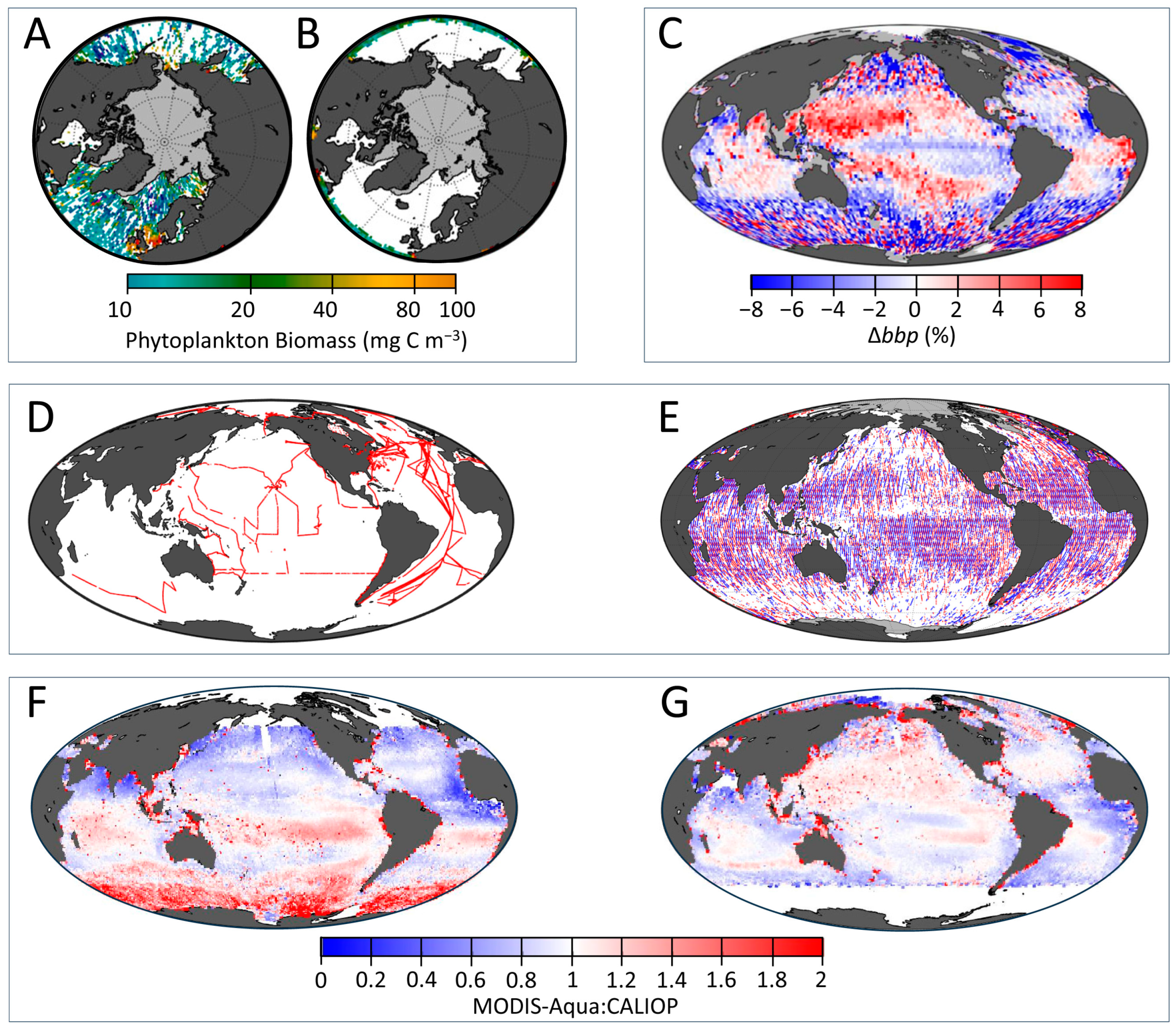
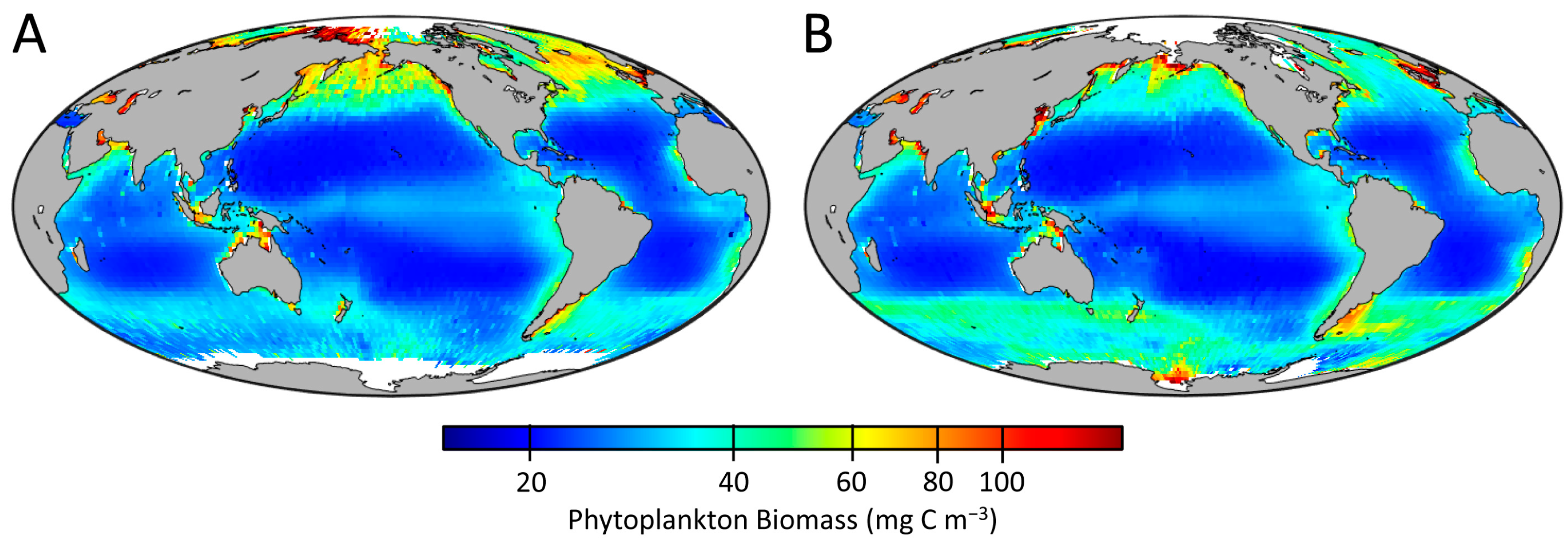
2. Lidar Advantage
3. On the Horizon—Vision for a Lidar Era in Oceanography
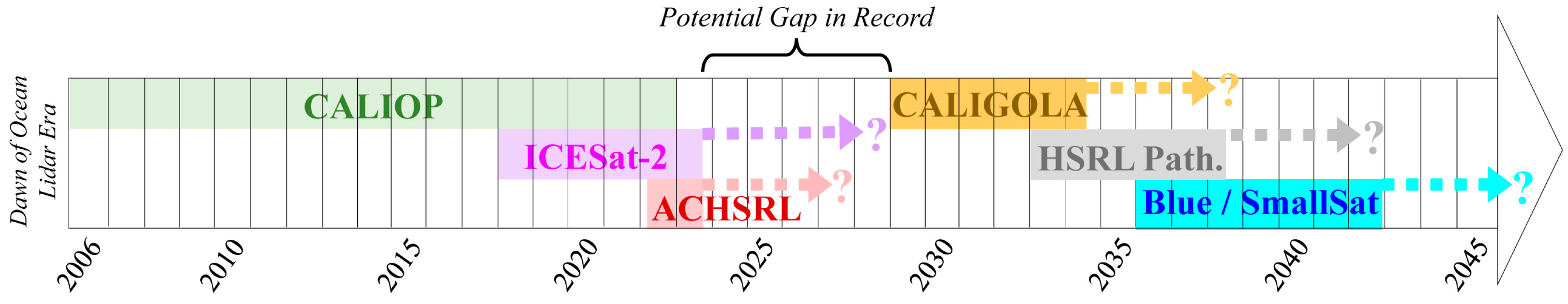
4. Filling the Gap
5. Outlook and Conclusions
Author Contributions
Funding
Data Availability Statement
Acknowledgments
Conflicts of Interest
References
- McClain, C.R. A decade of satellite ocean color observations. Annu. Rev. Mar. Sci. 2009, 1, 19–42. [Google Scholar] [CrossRef]
- Werdell, P.J.; Behrenfeld, M.J.; Bontempi, P.S.; Boss, E.; Cairns, B.; Davis, G.T.; Franz, B.A.; Gliese, U.B.; Gorman, E.T.; Hasekamp, O.; et al. The Plankton, Aerosol, Cloud, ocean Ecosystem mission: Status, science, advances. Bull. Am. Meteorol. Soc. 2019, 100, 1775–1794. [Google Scholar] [CrossRef]
- Hostetler, C.A.; Behrenfeld, M.J.; Hu, Y.; Hair, J.W.; Schulien, J.A. Spaceborne lidar in the study of marine systems. Annu. Rev. Mar. Sci. 2018, 10, 121–147. [Google Scholar] [CrossRef]
- Jamet, C.; Ibrahim, A.; Ahmad, Z.; Angelini, F.; Babin, M.; Behrenfeld, M.J.; Boss, E.; Cairns, B.; Churnside, J.; Chowdhary, J.; et al. Going beyond standard ocean color observations: Lidar and polarimetry. Front. Mar. Sci. 2019, 6, 251. [Google Scholar] [CrossRef]
- Behrenfeld, M.J.; Hu, Y.; Hostetler, C.A.; Dall’Olmo, G.; Rodier, S.D.; Hair, J.W.; Trepte, C.R. Space-based lidar measurements of global ocean carbon stocks. Geophys. Res. Lett. 2013, 40, 4355–4360. [Google Scholar] [CrossRef]
- Behrenfeld, M.J.; Hu, Y.; O’Malley, R.T.; Boss, E.S.; Hostetler, C.A.; Siegel, D.A.; Sarmiento, J.L.; Schulien, J.; Hair, J.W.; Lu, X.; et al. Annual boom–bust cycles of polar phytoplankton biomass revealed by space-based lidar. Nat. Geosci. 2017, 10, 118–122. [Google Scholar] [CrossRef]
- Behrenfeld, M.J.; Gaube, P.; Della Penna, A.; O’malley, R.T.; Burt, W.J.; Hu, Y.; Bontempi, P.S.; Steinberg, D.K.; Boss, E.S.; Siegel, D.A.; et al. Global satellite-observed daily vertical migrations of ocean animals. Nature 2019, 576, 257–261. [Google Scholar] [CrossRef]
- Lu, X.; Hu, Y.; Trepte, C.; Zeng, S.; Churnside, J.H. Ocean subsurface studies with the CALIPSO spaceborne lidar. J. Geophys. Res: Oceans 2014, 119, 4305–4317. [Google Scholar] [CrossRef]
- Lu, X.; Hu, Y.; Pelon, J.; Trepte, C.; Liu, K.; Rodier, S.; Zeng, S.; Lucker, P.; Verhappen, R.; Wilson, J.; et al. Retrieval of ocean subsurface particulate backscattering coefficient from space-borne CALIOP lidar measurements. Opt. Express 2016, 24, 29001–29008. [Google Scholar] [CrossRef]
- Lu, X.; Hu, Y.; Yang, Y. Ocean subsurface study from ICESat-2 mission. In Proceedings of the 2019 Photonics & Electromagnetics Research Symposium-Fall (PIERS-Fall) IEEE, Xiamen, China, 17–20 December 2019; pp. 910–918. [Google Scholar]
- Lu, X.; Hu, Y.; Yang, Y.; Bontempi, P.; Omar, A.; Baize, R. Antarctic spring ice-edge blooms observed from space by ICESat-2. Remote Sens. Environ. 2020, 245, 111827. [Google Scholar] [CrossRef]
- Hu, Y.; Behrenfeld, M.; Hostetler, C.; Pelon, J.; Trepte, C.; Hair, J.; Slade, W.; Cetinic, I.; Vaughan, M.; Lu, X.; et al. Ocean lidar measurements of beam attenuation and a roadmap to accurate phytoplankton biomass estimates. In Proceedings of the 27th International Laser Radar Conference (ILRC 27), New York, NY, USA, 5–10 July 2015; EDP Sciences: Les Ulis, France; Volume 119, p. 22003. [Google Scholar]
- Churnside, J.H.; McCarty, B.J.; Lu, X. Subsurface ocean signals from an orbiting polarization lidar. Remote Sens. 2013, 5, 3457–3475. [Google Scholar] [CrossRef]
- Dionisi, D.; Brando, V.E.; Volpe, G.; Colella, S.; Santoleri, R. Seasonal distributions of ocean particulate optical properties from spaceborne lidar measurements in Mediterranean and Black Sea. Remote Sens. Environ. 2020, 247, 111889. [Google Scholar] [CrossRef]
- Zhang, S.; Chen, P.; Zhang, Z.; Pan, D. Carbon Air–Sea Flux in the Arctic Ocean from CALIPSO from 2007 to 2020. Remote Sens. 2022, 14, 6196. [Google Scholar] [CrossRef]
- Zhang, Z.; Chen, P.; Zhong, C.; Xie, C.; Sun, M.; Zhang, S.; Chen, S.; Wu, D. Chlorophyll and POC in polar regions derived from spaceborne lidar. Front. Mar. Sci. 2023, 10, 1050087. [Google Scholar] [CrossRef]
- Sun, M.; Chen, P.; Zhang, Z.; Zhong, C.; Xie, C.; Pan, D. Evaluation of the CALIPSO Lidar-observed particulate backscattering coefficient on different spatiotemporal matchup scales. Front. Mar. Sci. 2023, 10, 1181268. [Google Scholar] [CrossRef]
- Zhang, Z.; Chen, P.; Jamet, C.; Dionisi, D.; Hu, Y.; Lu, X.; Pan, D. Retrieving bbp and POC from CALIOP: A deep neural network approach. Remote Sens. Environ. 2023, 287, 113482. [Google Scholar] [CrossRef]
- Zhong, C.; Chen, P.; Zhang, Z.; Sun, M.; Xie, C. CPUE retrieval from spaceborne lidar data: A case study in the Atlantic bigeye tuna fishing area and Antarctica fishing area. Front. Mar. Sci. 2022, 9, 1009620. [Google Scholar] [CrossRef]
- Vadakke-Chanat, S.; Jamet, C. Validation protocol for the evaluation of space-borne lidar particulate back-scattering coefficient bbp. Front. Remote Sens. 2023, 4, 1194580. [Google Scholar] [CrossRef]
- Garver, S.A.; Siegel, D.A. Inherent optical property inversion of ocean color spectra and its biogeochemical interpretation: I. Time series from the Sargasso Sea. J. Geophys. Res. 1997, 102, 18607–18625. [Google Scholar] [CrossRef]
- Maritorena, S.; Siegel, D.A.; Peterson, A.R. Optimization of a semianalytical ocean color model for global-scale applications. Appl. Opt. 2002, 41, 2705–2714. [Google Scholar] [CrossRef]
- Siegel, D.A.; Maritorena, S.; Nelson, N.B.; Hansell, D.A.; Lorenzi-Kayser, M. Global distribution and dynamics of colored dissolved and detrital organic materials. J. Geophys. Res. 2002, 107, 3228. [Google Scholar] [CrossRef]
- Lee, Z.P.; Carder, K.L.; Arnone, R.A. Deriving inherent optical properties from water color: A multi-band quasi-analytical algorithm for optically deep waters. Appl. Opt. 2002, 41, 5755–5772. [Google Scholar] [CrossRef] [PubMed]
- Werdell, P.J.; Franz, B.A.; Bailey, S.W.; Feldman, G.C.; Boss, E.; Brando, V.E.; Dowell, M.; Hirata, T.; Lavender, S.J.; Lee, Z.; et al. Generalized ocean color inversion model for retrieving marine inherent optical properties. Appl. Opt. 2013, 52, 2019–2037. [Google Scholar] [CrossRef] [PubMed]
- Winker, D.M.; Vaughan, M.A.; Omar, A.; Hu, Y.X.; Powell, K.A.; Liu, Z.Y.; Hunt, W.H.; Young, S.A. Overview of the CALIPSO Mission and CALIOP data processing algorithms. J. Atmos. Ocean. Technol. 2009, 26, 2310–2323. [Google Scholar] [CrossRef]
- Behrenfeld, M.J.; Hu, Y.; Bisson, K.M.; Lu, X.; Westberry, T.K. Retrieval of ocean optical and plankton properties with the satellite Cloud-Aerosol Lidar with Orthogonal Polarization (CALIOP) sensor: Background, data processing, and validation status. Remote Sens. Environ. 2022, 281, 113235. [Google Scholar] [CrossRef]
- Eayrs, C.; Li, X.; Raphael, M.N.; Holland, D.M. Rapid decline in Antarctic sea ice in recent years hints at future change. Nat. Geosci. 2021, 14, 460–464. [Google Scholar] [CrossRef]
- Rantanen, M.; Karpechko, A.Y.; Lipponen, A.; Nordling, K.; Hyvärinen, O.; Ruosteenoja, K.; Vihma, T.; Laaksonen, A. The Arctic has warmed nearly four times faster than the globe since 1979. Commun. Earth Environ. 2022, 3, 168. [Google Scholar] [CrossRef]
- Raphael, M.N.; Handcock, M.S. A new record minimum for Antarctic sea ice. Nat. Rev. Earth Environ. 2022, 3, 215–216. [Google Scholar] [CrossRef]
- Perring, A.E.; Mediavilla, B.; Wilbanks, G.D.; Churnside, J.H.; Marchbanks, R.; Lamb, K.D.; Gao, R.-S. Airborne Bioaerosol Observations Imply a Strong Terrestrial Source in the Summertime Arctic. J. Geophys. Res. Atmos. 2023, 128, e2023JD039165. [Google Scholar] [CrossRef]
- Clark, D.K.; Gordon, H.R.; Voss, K.J.; Ge, Y.; Broenkow, W.; Trees, C. Validation of atmospheric correction over the oceans. J. Geophys. Res. Atmosph. 1997, 102, 17209–17217. [Google Scholar] [CrossRef]
- Frouin, R.J.; Franz, B.A.; Ibrahim, A.; Knobelspiesse, K.; Ahmad, Z.; Cairns, B.; Chowdhary, J.; Dierssen, H.M.; Tan, J.; Dubovik, O.; et al. Atmospheric correction of satellite ocean-color imagery during the PACE era. Front. Earth Sci. 2019, 7, 145. [Google Scholar] [CrossRef] [PubMed]
- Collister, B.; Cook, A.; Hair, J.; Hostetler, C.; Ibrahim, A.; Boss, E.; Scarino, A.J.; Shingler, T.; Slade, W.; Twardowski, M.; et al. Airborne high spectral resolution lidar provides reliable measurements of particulate backscatter in the ocean. Remote Sens. Environ. 2023, 300, 113898. [Google Scholar] [CrossRef]
- Ibrahim, A.; Franz, B.A.; Ahmad, Z.; Bailey, S.W. Multiband atmospheric correction algorithm for ocean color retrievals. Front. Earth Sci. 2019, 7, 116. [Google Scholar] [CrossRef]
- Feng, L.; Hu, C. Cloud adjacency effects on top-of-atmosphere radiance and ocean color data products: A statistical assessment. Remote Sens. Environ. 2016, 174, 301–313. [Google Scholar] [CrossRef]
- Bulgarelli, B.; Kiselev, V.; Zibordi, G. Adjacency effects in satellite radiometric products from coastal waters: A theoretical analysis for the northern Adriatic Sea. Appl. Opt. 2017, 56, 854–869. [Google Scholar] [CrossRef] [PubMed]
- Babin, M.; Forget, M.-H. Ocean Colour Remote Sensing of Polar Regions; Babin, M., Arrigo, K., Bélanger, S., Forget, M.-H., Eds.; Reports of the Ocean Colour Coordinating Group; IOCCG: Dartmouth, NS, Canada, 2015; Chapter 1. [Google Scholar]
- Loisel, H.; Vantrepotte, V.; Jamet, C.; Dat, D.N. Challenges and new advances in ocean color remote sensing of coastal waters. Topics Oceanogr. 2013, 1–38. [Google Scholar] [CrossRef]
- Longhurst, A.R.; Bedo, A.W.; Harrison, W.G.; Head, E.J.H.; Sameoto, D.D. Vertical flux of respiratory carbon by oceanic diel migrant biota. Deep Sea Res. Part A 1990, 37, 685–694. [Google Scholar] [CrossRef]
- Nowicki, M.; DeVries, T.; Siegel, D.A. Quantifying the carbon export and sequestration pathways of the ocean’s biological carbon pump. Glob. Biogeochem. Cycles 2022, 36, e2021GB007083. [Google Scholar] [CrossRef]
- Hernández-León, S.; Franchy, G.; Moyano, M.; Menéndez, I.; Schmoker, C.; Putzeys, S. Carbon sequestration and zooplankton lunar cycles: Could we be missing a major component of the biological pump? Limnol. Oceanogr. 2010, 55, 2503–2512. [Google Scholar] [CrossRef]
- Coulter, A.; Cashion, T.; Cisneros-Montemayor, A.M.; Popov, S.; Tsui, G.; Le Manach, F.; Schiller, L.; Palomares, M.L.D.; Zeller, D.; Pauly, D. Using harmonized historical catch data to infer the expansion of global tuna fisheries. Fish. Res. 2020, 221, 105379. [Google Scholar] [CrossRef]
- Kelly, T.B.; Davison, P.C.; Goericke, R.; Landry, M.R.; Ohman, M.D.; Stukel, M.R. The importance of mesozooplankton diel vertical migration for sustaining a mesopelagic food web. Front. Mar. Sci. 2019, 6, 508. [Google Scholar] [CrossRef]
- Werdell, P.J.; Bailey, S.W. An improved in-situ bio-optical data set for ocean color algorithm development and satellite data product validation. Remote Sens. Environ. 2005, 98, 122–140. [Google Scholar] [CrossRef]
- Bisson, K.M.; Boss, E.; Werdell, P.J.; Ibrahim, A.; Behrenfeld, M.J. Particulate backscattering in the global ocean: A comparison of independent assessments. Geophys. Res. Lett. 2021, 48, e2020GL090909. [Google Scholar] [CrossRef] [PubMed]
- Bisson, K.M.; Boss, E.; Werdell, P.J.; Ibrahim, A.; Frouin, R.; Behrenfeld, M.J. Seasonal bias in global ocean color observations. Appl. Opt. 2021, 60, 6978–6988. [Google Scholar] [CrossRef] [PubMed]
- Bisson, K.M.; Werdell, P.J.; Chase, A.P.; Kramer, S.J.; Cael, B.B.; Boss, E.; McKinna, L.I.W.; Behrenfeld, M.J. Informing ocean color inversion products by seeding with ancillary observations. Opt. Expr. 2023, 31, 40557–40572. [Google Scholar] [CrossRef]
- Cheng, L.; von Schuckmann, K.; Abraham, J.P.; Trenberth, K.E.; Mann, M.E.; Zanna, L.; England, M.H.; Zika, J.D.; Fasullo, J.T.; Yu, Y.; et al. Past and future ocean warming. Nat. Rev. Earth Environ. 2022, 3, 776–794. [Google Scholar] [CrossRef]
- Doney, S.C.; Busch, D.S.; Cooley, S.R.; Kroeker, K.J. The impacts of ocean acidification on marine ecosystems and reliant human communities. Annu. Rev. Environ. Resour. 2020, 45, 83–112. [Google Scholar] [CrossRef]
- Behrenfeld, M.J.; O’Malley, R.T.; Siegel, D.A.; McClain, C.R.; Sarmiento, J.L.; Feldman, G.C.; Milligan, A.J.; Falkowski, P.G.; Letelier, R.M.; Boss, E.S. Climate-driven trends in contemporary ocean productivity. Nature 2006, 444, 752–755. [Google Scholar] [CrossRef]
- Behrenfeld, M.J.; O’Malley, R.T.; Boss, E.S.; Westberry, T.K.; Graff, J.R.; Halsey, K.H.; Milligan, A.J.; Siegel, D.A.; Brown, M.B. Revaluating ocean warming impacts on global phytoplankton. Nat. Clim. Chang. 2016, 6, 323–330. [Google Scholar] [CrossRef]
- Martiny, A.C.; Ustick, L.; Westberry, T.; Behrenfeld, M.J. Genomic-to-space measurements reveal global ocean nutrient stress. Nature, 2023; in review. [Google Scholar]
- Kourantidou, M.; Jin, D. Mesopelagic-epipelagic fish nexus in viability and feasibility of commercial-scale mesopelagic fisheries. Nat. Resour. Model. 2022, 35, e12350. [Google Scholar] [CrossRef]
- Gj, J. Mesopelagic fish, a large potential resource in the Arabian Sea. Deep Sea Res. Part A 1984, 31, 1019–1035. [Google Scholar]
- Grimaldo, E.; Grimsmo, L.; Alvarez, P.; Herrmann, B.; Møen Tveit, G.; Tiller, R.; Slizyte, R.; Aldanondo, N.; Guldberg, T.; Toldnes, B.; et al. Investigating the potential for a commercial fishery in the Northeast Atlantic utilizing mesopelagic species. ICES J. Mar. Sci. 2020, 77, 2541–2556. [Google Scholar] [CrossRef]
- Alvheim, A.R.; Kjellevold, M.; Strand, E.; Sanden, M.; Wiech, M. Mesopelagic species and their potential contribution to food and feed security—A case study from Norway. Foods 2020, 9, 344. [Google Scholar] [CrossRef]
- Prellezo, R. Exploring the economic viability of a mesopelagic fishery in the Bay of Biscay. ICES J. Mar. Sci. 2019, 76, 771–779. [Google Scholar] [CrossRef]
- Lamhauge, S.; Jacobsen, J.A.; Jákupsstovu, H.; Valdemarsen, J.W.; Sigurdsson, T.; Bardarsson, B.; Filin, A. Fishery and Utilisation of Mesopelagic Fishes and Krill in the North Atlantic; Nordic Council of Ministers: Copenhagen, Denmark, 2008. [Google Scholar]
- Burger, F.A.; Terhaar, J.; Frölicher, T.L. Compound marine heatwaves and ocean acidity extremes. Nat. Commun. 2022, 13, 4722. [Google Scholar] [CrossRef] [PubMed]
- D’Sa, E.J.; Tzortziou, M.; Liu, B. Extreme events and impacts on organic carbon cycles from ocean color remote sensing: Review with case study, challenges, and future directions. Earth-Sci. Rev. 2023, 243, 104503. [Google Scholar] [CrossRef]
- Frölicher, T.L.; Laufkötter, C. Emerging risks from marine heat waves. Nat. Commun. 2018, 9, 650. [Google Scholar] [CrossRef]
- Lannuzel, D.; Tedesco, L.; Van Leeuwe, M.; Campbell, K.; Flores, H.; Delille, B.; Miller, L.; Stefels, J.; Assmy, P.; Bowman, J.; et al. The future of Arctic sea-ice biogeochemistry and ice-associated ecosystems. Nat. Clim. Chang. 2020, 10, 983–992. [Google Scholar] [CrossRef]
- Jambeck, J.R.; Geyer, R.; Wilcox, C.; Siegler, T.R.; Perryman, M.; Andrady, A.; Narayan, R.; Law, K.L. Plastic waste inputs from land into the ocean. Science 2015, 347, 768–771. [Google Scholar] [CrossRef]
- Simon, N.; Schulte, M.L. Stopping global plastic pollution: The case for an international convention. Ecol. Publ. Ser. 2017, 43, 1–52. [Google Scholar]
- Neukermans, G.; Harmel, T.; Galí, M.; Rudorff, N.; Chowdhary, J.; Dubovik, O.; Hostetler, C.; Hu, Y.; Jamet, C.; Knobelspiesse, K.; et al. Harnessing remote sensing to address critical science questions on ocean-atmosphere interactions. Elementa 2018, 6, 71. [Google Scholar] [CrossRef]
- Hoge, F.E.; Lyon, P.E.; Swift, R.N.; Yungel, J.K.; Abbott, M.R.; Letelier, R.M.; Esaias, W.E. Validation of Terra-MODIS phytoplankton chlorophyll fluorescence line height. I. Initial Airborne Lidar Results. Appl. Opt. 2003, 42, 2767–2771. [Google Scholar] [PubMed]
- Vasilkov, A.P.; Goldin, Y.A.; Gureev, B.A.; Hoge, F.E.; Swift, R.N.; Wright, C.W. Airborne polarized lidar detection of scattering layers in the ocean. Appl. Opt. 2001, 40, 4353–4364. [Google Scholar] [CrossRef] [PubMed]
- Behrenfeld, M.J.; Worthington, K.; Sherrell, R.M.; Chavez, F.P.; Strutton, P.; McPhaden, M.; Shea, D.M. Controls on tropical Pacific Ocean productivity revealed through nutrient stress diagnostics. Nature 2006, 442, 1025–1028. [Google Scholar] [CrossRef] [PubMed]
- Behrenfeld, M.J.; Milligan, A.J. Photophysiological expressions of iron stress in phytoplankton. Annu. Rev. Mar. Sci. 2013, 5, 217–246. [Google Scholar] [CrossRef]
- Feen, M.L. Chlorophyll Fluorescence Corrections from a Rapid-Profiling, Autonomous Wirewalker. Ph.D. Thesis, University of Rhode Island, Kingston, RI, USA, 2020. [Google Scholar]
- Biermann, L.; Clewley, D.; Martinez-Vicente, V.; Topouzelis, K. Finding plastic patches in coastal waters using optical satellite data. Sci. Rep. 2020, 10, 5364. [Google Scholar] [CrossRef]
- Martínez-Vicente, V.; Clark, J.R.; Corradi, P.; Aliani, S.; Arias, M.; Bochow, M.; Bonnery, G.; Cole, M.; Cózar, A.; Donnelly, R.; et al. Measuring marine plastic debris from space: Initial assessment of observation requirements. Remote Sens. 2019, 11, 2443. [Google Scholar] [CrossRef]
- Schulien, J.A.; Behrenfeld, M.J.; Hair, J.W.; Hostetler, C.A.; Twardowski, M.S. Vertically-resolved phytoplankton carbon and net primary production from a high spectral resolution lidar. Opt. Expr. 2017, 25, 13577–13587. [Google Scholar] [CrossRef]
- Hoge, F.E.; Swift, R.N.; Yungel, J.K. Oceanic radiance model development and validation: Application of airborne active-passive ocean color spectral measurements. Appl. Opt. 1995, 34, 3468–3476. [Google Scholar] [CrossRef]
- Siegel, D.; Dickey, T.; Washburn, L.; Hamilton, M.; Mitchell, B. Optical determination of particulate abundance and production variations in the oligotrophic ocean. Deep-Sea Res. 1989, 36, 211–222. [Google Scholar] [CrossRef]
- Kheireddine, M.; Antoine, D. Diel variability of the beam attenuation and backscattering coefficients in the northwestern Mediterranean Sea (BOUSSOLE site). J. Geophys. Res. Oceans. 2014, 119, 5465–5482. [Google Scholar] [CrossRef]
- Poulin, C.; Antoine, D.; Huot, Y. Diurnal variations of the optical properties of phytoplankton in a laboratory experiment and their implication for using inherent optical properties to measure biomass. Opt. Expr. 2018, 26, 711–729. [Google Scholar] [CrossRef] [PubMed]
- Dall’Olmo, G.; Boss, E.; Behrenfeld, M.J.; Westberry, T.K.; Courties, C.; Prieur, L.; Pujo-Pay, M.; Hardman-Mountford, N.; Moutin, T. Inferring phytoplankton carbon and eco-physiological rates from diel cycles of spectral particulate beam-attenuation coefficient. Biogeosciences 2011, 8, 3423–3439. [Google Scholar] [CrossRef]
- Zawada, D.G.; Zaneveld, J.R.V.; Boss, E.; Gardner, W.D.; Richardson, M.J.; Mishonov, A.V. A comparison of hydrographically and optically derived mixed layer depths. J. Geophys. Res. 2005, 110, C11001. [Google Scholar] [CrossRef]
- Parrish, C.E.; Magruder, L.A.; Neuenschwander, A.L.; Forfinski-Sarkozi, N.; Alonzo, M.; Jasinski, M. Validation of ICESat-2 ATLAS bathymetry and analysis of ATLAS’s bathymetric mapping performance. Remote Sens. 2019, 11, 1634. [Google Scholar] [CrossRef]
- Neumann, T.; Magruder, L.; Kurtz, N. ICESat-2 Mission: Contributions of a spaceborne lidar to ocean science. In Proceedings of the OCEANS 2022, Hampton Roads, VA, USA, 17–20 October 2022; pp. 1–5. [Google Scholar]
- Bisson, K.M.; Cael, B.B. How are under ice phytoplankton related to sea ice in the Southern Ocean? Geophys. Res. Lett. 2021, 48, e2021GL095051. [Google Scholar] [CrossRef]
- Palombi, L.; Lognoli, D.; Raimondi, V. Fluorescence LIDAR remote sensing of oils: Merging spectral and time-decay measurements. In Proceedings of the Remote Sensing for Agriculture, Ecosystems, and Hydrology XV, Dresden, Germany, 16 October 2013; Volume 8887, pp. 110–117. [Google Scholar]
- Schulien, J.A.; Della Penna, A.; Gaube, P.; Chase, A.P.; Haëntjens, N.; Graff, J.R.; Hair, J.W.; Hostetler, C.A.; Scarino, A.J.; Boss, E.S.; et al. Shifts in phytoplankton community structure across an anticyclonic eddy revealed from high spectral resolution lidar scattering measurements. Front. Mar. Sci. 2020, 7, 493. [Google Scholar] [CrossRef]
- Hu, Y.; Lu, X.; Zeng, X.; Gatebe, C.; Fu, Q.; Yang, P.; Weimer, C.; Stamnes, S.; Baize, R.; Omar, A.; et al. Linking lidar multiple scattering profiles to snow depth and snow density: An analytical radiative transfer analysis and the implications for remote sensing of snow. Front. Remote Sens. 2023, 4, 1202234. [Google Scholar] [CrossRef]
- Kiefer, D.A. Fluorescence properties of natural phytoplankton populations. Mar. Biol. 1973, 22, 263–269. [Google Scholar] [CrossRef]
- Magney, T.S.; Bowling, D.R.; Logan, B.A.; Grossmann, K.; Stutz, J.; Blanken, P.D.; Burns, S.P.; Cheng, R.; Garcia, M.A.; Köhler, P.; et al. Mechanistic evidence for tracking the seasonality of photosynthesis with solar-induced fluorescence. Proc. Nat. Acad. Sci. USA 2019, 116, 11640–11645. [Google Scholar] [CrossRef]
- Guanter, L.; Zhang, Y.; Jung, M.; Joiner, J.; Voigt, M.; Berry, J.A.; Frankenberg, C.; Huete, A.R.; Zarco-Tejada, P.; Lee, J.E.; et al. Global and time-resolved monitoring of crop photosynthesis with chlorophyll fluorescence. Proc. Nat. Acad. Sci. USA 2014, 111, E1327–E1333. [Google Scholar] [CrossRef] [PubMed]
- Guanter, L.; Bacour, C.; Schneider, A.; Aben, I.; van Kempen, T.A.; Maignan, F.; Retscher, C.; Köhler, P.; Frankenberg, C.; Joiner, J.; et al. The TROPOSIF global sun-induced fluorescence dataset from the Sentinel-5P TROPOMI mission. Earth Syst. Sci. Data. 2021, 13, 5423–5440. [Google Scholar]
- Behrendt, A.; Nakamura, T.; Onishi, M.; Baumgart, R.; Tsuda, T. Combined Raman lidar for the measurement of atmospheric temperature, water vapor, particle extinction coefficient, and particle backscatter coefficient. Appl. Opt. 2002, 41, 7657–7666. [Google Scholar] [CrossRef] [PubMed]
- Park, S.H.; Kim, Y.-G.; Kim, D.; Cheong, H.-D.; Choi, W.-S.; Lee, J.-I. Selecting Characteristic Raman Wavelengths to Distinguish Liquid Water, Water Vapor, and Ice Water. J. Opt. Soc. Korea 2010, 14, 209–214. [Google Scholar] [CrossRef]
- Ansmann, A.; Wandinger, U.; Riebesell, M.; Weitkamp, C.; Michaelis, W. Independent measurement of extinction and backscatter profiles in cirrus clouds by using a combined Raman elastic-backscatter lidar. Appl. Opt. 1992, 31, 7113–7131. [Google Scholar] [CrossRef] [PubMed]
- Shipley, S.T.; Tracy, D.H.; Eloranta, E.W.; Trauger, J.T.; Sroga, J.T.; Roesler, F.L.; Weinman, J.A. High spectral resolution lidar to measure optical scattering properties of atmospheric aerosols. 1: Theory and instrumentation. Appl. Opt. 1983, 22, 3716–3724. [Google Scholar] [CrossRef] [PubMed]
- Hair, J.W.; Hostetler, C.A.; Cook, A.L.; Harper, D.B.; Ferrare, R.A.; Mack, T.L.; Welch, W.; Izquierdo, L.R.; Hovis, F.E. Airborne high spectral resolution lidar for profiling aerosol optical properties. Appl. Opt. 2008, 47, 6734–6752. [Google Scholar] [CrossRef] [PubMed]
- Bruneau, D.; Pelon, J.; Blouzon, F.; Spatazza, J.; Genau, P.; Buchholtz, G.; Amarouche, N.; Abchiche, A.; Aouji, O. 355-nm high spectral resolution airborne lidar LNG: System description and first results. Appl. Opt. 2015, 54, 8776–8785. [Google Scholar] [CrossRef]
- Hostetler, C.; Smith, J.; Hare, R.; Nehrir, A.; Seaman, S.; Notari, A.; Ferrare, R.; Burton, S.; Powell, K.; Thorsen, T.; et al. Devices meeting requirements for an ocean lidar mission have yet to be developed, but it is more a straightforward engineering challenge, rather than a technological challenge, to modify existing technology for future ocean lidars. IEEE, 2024; in review. [Google Scholar]
- Eidam, E.; Walker, C.; Bisson, K.; Paris, M.; Cooper, L. Novel application of ICESat-2 ATLAS data to determine coastal light attenuation as a proxy for suspended particulate matter. In Proceedings of the OCEANS 2022, Hampton Roads, VA, USA, 17–20 October 2022; pp. 1–7. [Google Scholar]
- Lu, X.; Hu, Y.; Yang, Y.; Neumann, T.; Omar, A.; Baize, R.; Vaughan, M.; Rodier, S.; Getzewich, B.; Lucker, P.; et al. New Ocean Subsurface Optical Properties from Space Lidars: CALIOP/CALIPSO and ATLAS/ICESat-2. Earth Space Sci. 2021, 8, e2021EA001839. [Google Scholar] [CrossRef]
- Markus, T.; Neumann, T.; Martino, A.; Abdalati, W.; Brunt, K.; Csatho, B.; Farrell, S.; Fricker, H.; Gardner, A.; Harding, D.; et al. The Ice, Cloud, and land Elevation Satellite-2 (ICESat-2): Science requirements, concept, and implementation. Remote Sens. Environ. 2017, 190, 260–273. [Google Scholar] [CrossRef]
- Graff, J.R.; Westberry, T.K.; Milligan, A.J.; Brown, M.B.; Dall’Olmo, G.; Dongen-Vogels, V.; Reifel, K.M.; Behrenfeld, M.J. Analytical phytoplankton carbon measurements spanning diverse ecosystems. Deep-Sea Res. 2015, 102, 16–25. [Google Scholar] [CrossRef]
- Storm, M.; Cao, H.; Albert, M.; Engin, D. Cubesat lidar concepts for ranging, topology, sample capture, surface, and atmospheric science. In Proceedings of the 31st Annual AiAA/USU 2017 Conference on Small Satellites, Logan, UT, USA, 5–10 April 2017; Available online: https://digitalcommons.usu.edu/smallsat/2017/all2017/250/ (accessed on 15 November 2023).
- Lacour, L.; Larouche, R.; Babin, M. In situ evaluation of spaceborne CALIOP lidar measurements of the upper-ocean particle backscattering coefficient. Opt. Expr. 2020, 28, 26989–26999. [Google Scholar] [CrossRef] [PubMed]
- Scheick, J.; Leong, W.J.; Bisson, K.; Arendt, A.; Bhushan, S.; Fair, Z.; Hagen, N.R.; Henderson, S.; Knuth, F.; Li, T.; et al. icepyx: Querying, obtaining, analyzing, and manipulating ICESat-2 datasets. J. Open Source Softw. 2023, 8, 4912. [Google Scholar] [CrossRef]

| Instrument | Ocean Relevant Technical Characteristic | Enabled Science Strengths/Challenges |
|---|---|---|
| CALIOP | 532 nm cross-polarized channel |
|
| 532 nm co-polarized channel | ||
| Detectors: low sensitivity/~20 m vertical sampling | ||
| Nadir viewing | ||
| 16-day orbit repeat cycle | ||
| ATLAS | 532 nm emission channel |
|
| Detectors: high-sensitivity single photon counting/cm-scale vertical sampling | ||
| Nadir viewing | ||
| 91-day orbit repeat cycle | ||
| CALIGOLA | 532 nm cross-polarized channel |
|
| 532 nm co-polarized channel | ||
| 355 nm cross-polarized channel | ||
| 355 nm co-polarized channel | ||
| 404 nm vibrational water Raman | ||
| 645 nm vibrational water Raman | ||
| 680 nm chlorophyll fluorescence | ||
| 455 nm fluorescence channel | ||
| Detectors: high sensitivity/<1 m vertical sampling | ||
| Off nadir tilt | ||
| 16-day orbit repeat cycle | ||
| HSRL Pathfinder | 532 nm cross-polarized channel |
|
| 532 nm co-polarized channel | ||
| 532 nm HSRL channel | ||
| 680 nm chlorophyll fluorescence | ||
| Detectors: high sensitivity/<1 m vertical sampling | ||
| Blue Lidar | 486 nm cross-polarized channel |
|
| 486 nm co-polarized channel | ||
| 486 nm HSRL channel | ||
| 680 nm chlorophyll fluorescence | ||
| Other specifications to be defined |
Disclaimer/Publisher’s Note: The statements, opinions and data contained in all publications are solely those of the individual author(s) and contributor(s) and not of MDPI and/or the editor(s). MDPI and/or the editor(s) disclaim responsibility for any injury to people or property resulting from any ideas, methods, instructions or products referred to in the content. |
© 2023 by the authors. Licensee MDPI, Basel, Switzerland. This article is an open access article distributed under the terms and conditions of the Creative Commons Attribution (CC BY) license (https://creativecommons.org/licenses/by/4.0/).
Share and Cite
Behrenfeld, M.J.; Lorenzoni, L.; Hu, Y.; Bisson, K.M.; Hostetler, C.A.; Di Girolamo, P.; Dionisi, D.; Longo, F.; Zoffoli, S. Satellite Lidar Measurements as a Critical New Global Ocean Climate Record. Remote Sens. 2023, 15, 5567. https://doi.org/10.3390/rs15235567
Behrenfeld MJ, Lorenzoni L, Hu Y, Bisson KM, Hostetler CA, Di Girolamo P, Dionisi D, Longo F, Zoffoli S. Satellite Lidar Measurements as a Critical New Global Ocean Climate Record. Remote Sensing. 2023; 15(23):5567. https://doi.org/10.3390/rs15235567
Chicago/Turabian StyleBehrenfeld, Michael J., Laura Lorenzoni, Yongxiang Hu, Kelsey M. Bisson, Chris A. Hostetler, Paolo Di Girolamo, Davide Dionisi, Francesco Longo, and Simona Zoffoli. 2023. "Satellite Lidar Measurements as a Critical New Global Ocean Climate Record" Remote Sensing 15, no. 23: 5567. https://doi.org/10.3390/rs15235567
APA StyleBehrenfeld, M. J., Lorenzoni, L., Hu, Y., Bisson, K. M., Hostetler, C. A., Di Girolamo, P., Dionisi, D., Longo, F., & Zoffoli, S. (2023). Satellite Lidar Measurements as a Critical New Global Ocean Climate Record. Remote Sensing, 15(23), 5567. https://doi.org/10.3390/rs15235567