Review

UAVs and 3D City Modeling to Aid Urban Planning and Historic Preservation: A Systematic Review

by
Dingkun Hu
and
Jennifer Minner
*
Department of City and Regional Planning, Cornell University, Ithaca, NY 14850, USA
*
Author to whom correspondence should be addressed.
Remote Sens. 2023, 15(23), 5507; https://doi.org/10.3390/rs15235507
Submission received: 15 October 2023 / Revised: 21 November 2023 / Accepted: 23 November 2023 / Published: 26 November 2023

Abstract

:
Drone imagery has the potential to enrich urban planning and historic preservation, especially where it converges with the growing creation and use of 3D models in the context of cities and metro regions. Nevertheless, the widespread adoption of drones in these fields faces limitations, and there is a shortage of research addressing this issue. Therefore, we have conducted a systematic literature review of articles published between 2002 and 2022 drawing from reputable academic repositories, including Science Direct, Web of Science, and China National Knowledge Infrastructure (CNKI), to identify current gaps in the existing research on the application of UAVs to the creation of 3D models in the contexts of urban planning and historic preservation. Our findings indicate five research shortcomings for 3D city modeling: limited participation of planning experts, research focus imbalance, lack of usage for special scenarios, lack of integration with smart city planning, and limited interdisciplinary collaboration. In addition, this study acknowledges current limitations around UAV applications and discusses possible countermeasures along with future prospects.

1. Introduction

Urban planning and historic preservation (in this paper, we use the term “historic preservation”, which is the most common term used in the U.S. for the professional practice of conservation of buildings, structures, landscapes, and other features of cities; it is important to note that other terms may be more common in other national and local contexts, such as heritage conservation, urban preservation, building preservation, building reuse, cultural heritage, etc.) involve the process of systematically collecting and using spatial data to manage change in the built environment. These fields are generally supported by imagery and data gathered through aerial-based remote sensing technologies such as satellites and airplanes. These technologies provide planning practitioners and researchers with evidence-based information, helping them to understand the built environment [1,2]. The use of unmanned aerial vehicles (UAVs), commonly referred to as drones, is a rapidly advancing technology. UAVs have become more accessible for urban planning and historic preservation due to their lower cost of acquisition and easier entry requirements for new pilots in comparison to airborne and satellite platforms [3]. UAVs are extensively utilized for purposes such as aerial photography, surveying, and mapping, agricultural tasks, search and rescue operations, and military applications, as well as news reporting and film and television production [4,5,6,7]. Today, UAVs can carry out a variety of tasks upon need, with a set of ever-advanced features including aerial photography, surveying, mapping, and LiDAR scanning. Their use as tools for improving the sensing of landscapes and the built environment suggests their potential significance for research and professional practice in urban planning, historic preservation, and allied fields.
In terms of technical characteristics, UAV technology has the advantages of small volume, low altitude, slow flight speed, light weight, and wide shooting range [8,9]. UAV technology has gradually transitioned from development experiments to practical applications in examples around the world [10,11]. Furthermore, UAV technology enables users to rapidly acquire spatial information about various aspects of the environment, including land, built structures, and natural resources [9,12]. UAV technology has been applied in three-dimensional scene reconstruction [13], forest modeling [14], and historical and cultural survey and protection [15]; in addition, UAVs can be used to capture high-resolution 2D datasets at a range of scales to generate 3D models using the “Structure-from-Motion” (SfM) process [16].
Urban and regional planning face the challenges of understanding and responding to rapid change in the urban environment. Therefore, having access to high-quality and up-to-date spatial information can be of great assistance in managing these city changes. Planners aid public officials in exploring multiple future scenarios with high-quality visualizations. Professionals in historic preservation similarly must help stakeholders to understand building conditions and survey entire districts for cultural resources. Google Street View and satellite imagery are available tools, although they have important limitations, as planners are limited to available images that may not be up to date [17,18]. UAVs have demonstrated their suitability for rapid urban modeling and aerial support, allowing both researchers and practitioners to produce up-to-date imagery using UAVs that are specific to particular needs and high resolution [19]. Among recent studies, planners have used UAV aerial survey technology for rapid urban modeling and to obtain information in planning surveys, and a number of studies have verified that UAV surveying can produce higher resolution images that cater to specific needs. Researchers have integrated UAVs into areas closely associated with urban planning and historic preservation, and have evaluated the current challenges associated with the utilization of UAV technology in planning practice in light of the growing use of UAVs in a variety of contexts [20]. In their paper, the authors identified opportunities to enhance 3D modeling and visualization for scenario planning and public discussion of alternatives.
3D modeling is a well-established concept that is primarily used for the visualization of physical objects and structures. In contrast, digital twins represent a more dynamic concept that expands on 3D modeling by incorporating real-time data and connectivity with physical systems [21]. Both 3D modeling and digital twins are valuable academic tools catering to various disciplines with different objectives. With the increasing interest in the production of 3D modeling and the creation and maintenance of digital twins for urban planning and historic preservation, researchers have started to explore the use of UAVs to augment these models. While the manual cost and time required to generate and render 3D models for urban planning can be severe, UAVs have the advantages of low initial cost and short time required for data acquisition. The use of UAV aerial photography in urban planning mostly remains at the image collection stage, with image analysis and data measurement being limited. Integration with existing tools and methods used by planners and historic preservation professionals remains uncertain, although the adoption of machine learning techniques in planning may make image analysis more common in the future. UAV technology has not been fully integrated into 3D modeling processes or the practical application stage of Geographic Information Systems (GIS). Further development is necessary to enhance its potential for creating three-dimensional models. The enhancement of the creation and maintenance of digital twins is crucial for urban planning and the improvement of planning support systems. We hypothesize that combining UAVs with 3D modeling could aid in integrating and analyzing information about the built environment. In recent years, rapid modeling through UAV aerial photography technology and GIS, Pix4Dmapper (Pix4D version 4.8 SA, Lausanne, Switzerland), Smart3D/ContextCapture (version 10.20.0.4145 Bentley Systems, Inc., Exton, PA, USA), PhotoScan (version 2.0.3 Agisoft LLC, St. Petersburg, Russia), and other software has begun to appear in urban planning [22], suggesting a tendency towards the expanded application of UAVs in the field of urban planning.
The primary objective of utilizing UAVs is not merely the pursuit of technological advancement in isolation; rather, it is to significantly enhance the processes of data acquisition and analysis in the fields of urban planning and historic preservation. These domains often grapple with the limitations of existing data sources such as Google Street View and satellite imagery, which may not provide the up-to-date and high-quality information required to effectively manage changes in the urban environment. The integration of UAV technology aims to address this pressing issue by providing practical solutions. By harnessing the capabilities of UAVs, we intend to bridge the existing gap between the demand for accurate and timely spatial data and the constraints of current methods. This bridge is crucial to fulfilling the essential needs of urban planning and historic preservation. UAVs present a pathway to improved quality and accessibility of the data needed for these disciplines, ultimately facilitating more informed decision-making. In our comprehensive study, we adopt a panoramic approach to offer readers a thorough understanding of how UAV technology is steadily becoming an integral part of urban planning and historic preservation practices. By encompassing a wide range of applications, challenges, and emerging trends, our research aims to provide insights that cater to the diverse needs of researchers, practitioners, and policymakers. Our intent is to provide a valuable and comprehensive reference, enabling readers to develop a holistic comprehension of this dynamic and evolving subject area.
The guiding questions for this paper are as follows. First, how can UAV technology be effectively applied as a 3D modeling tool in urban planning and historic preservation? Second, what are the existing research gaps within the published articles? Third, what limitations significantly impact the implementation of UAVs?
The subsequent sections of this paper offer a comprehensive overview of our research methodology, including details on the systematic literature review, materials and methods employed, and incorporation of bibliometric analysis. Moreover, this paper explores specific case studies that showcase practical applications of UAVs in planning and historic preservation contexts, providing valuable insights into their deployment and efficacy in supporting various aspects of these fields. Additionally, our analysis delves into the opportunities and barriers associated with leveraging drone technology to facilitate the creation and utilization of digital twins, shedding light on the potential benefits and challenges of integrating UAVs into planning and historic preservation practices.
This article responds to the needs outlined in the Special Issue on 3D City Modelling and Remote Sensing: Advances, Challenges, and New Technologies for advancements in capabilities for modeling at scales from individual buildings to whole cities in their geospatial contexts [23]. Our paper delves into the evolving role of Unmanned Aerial Vehicles (UAVs) as a transformative tool in historic preservation and urban planning. The central theme of our work aligns with the broader goal of leveraging advancements in remote sensing technologies to enhance planning and preservation practices within urban areas. By systematically reviewing the literature and conducting a comprehensive analysis, we aim to identify specific ways in which UAV technology contributes to the improvement of spatial data acquisition and analysis.
As digital societies increasingly rely on information, our paper emphasizes the critical role of UAVs in providing accurate and up-to-date spatial data for urban planning and historic preservation. The integration of UAV technology into these fields is pivotal in light of the limitations of existing data sources such as Google Street View and satellite imagery. Our study highlights the potential of UAVs to bridge the gap between the demand for high-quality spatial information and the constraints of current methods. By adopting a panoramic approach, we explore diverse applications, challenges, and emerging trends, contributing to the broader discourse on the significance of remote sensing in urban environments.
Moreover, our research addresses the thematic emphasis of the special issue by specifically examining how UAVs can serve as a 3D modeling tool in urban planning and historic preservation. We analyze existing research gaps within published articles, identifying areas where further exploration and innovation are needed. Through case studies, we provide practical insights into the deployment and efficacy of UAVs in supporting various aspects of planning and preservation. Additionally, our analysis explores opportunities and barriers associated with integrating drone technology to facilitate the creation and utilization of digital twins, a concept that is gaining prominence in the context of urban planning.
This paper underscores the growing synergy between Building Information Models (BIM), Geographic Information Systems (GIS), and UAV technology. The convergence of these domains holds the potential to create more detailed and integrated 3D city models, offering a unified view of geospatial information. As smart cities increasingly demand integrated views and data standards, the integration of BIM and GIS with UAV technology is emerging as a crucial avenue for future developments in urban planning. Our paper aims to contribute valuable insights into the evolving landscape of remote sensing technologies, offering a foundation for further research that can elevate the importance of these technologies to aid in improving planning and preservation within urban areas.

2. Materials and Methods

In this paper, we have conducted a systematic literature review to investigate the application of UAVs for 3D modeling in urban planning along with potential issues. Relevant literature from the past two decades was analyzed through a systematic review. Selection of papers was based on the Preferred Reporting Items for Systematic Reviews and Meta-Analyses (PRISMA) guidelines [24].

2.1. Eligibility Criteria

The selection of papers was based on the following specific inclusion criteria: studies published between 2002 and 2022 and studies addressing the use of UAVs and 3D modeling in urban planning-related fields, including research articles, review articles, and technical notes. Thanks to the authors’ dual language proficiency, we decided to include both English and Chinese language articles in the search.
To ensure a high level of quality, we applied the following exclusion criteria: articles discussing the application of UAVs in fields unrelated to planning and articles published before 2002; in addition, we excluded book chapters, letters to editors, and conceptual papers. It is important to highlight that the manual screening process, wherein articles were rigorously assessed based on their titles and abstracts, resulted in the exclusion of a considerable number of studies. The predominant reason for exclusion was discernible misalignment with the central theme of our research. A substantial portion of these excluded articles demonstrated a technical orientation or were focused on non-planning topics, encompassing subjects such as path planning, motion planning, machine learning, inspection and monitoring, and other non-relevant areas. This stringent screening procedure ensured that our analysis encompassed only studies closely aligned with the core objectives of our research.

2.2. Information Sources

Research was conducted using three online search databases: Science Direct, Web of Science, and China National Knowledge Infrastructure (CNKI). The filter options available on these databases were utilized to identify relevant papers in accordance with the eligibility criteria outlined above.

2.3. Search

The search was carried out using specific keywords (“UAV” OR “Unmanned Aerial Vehicle” OR “Drone”) AND (“3D” OR “Three Dimensional” OR “Digital Twin”) AND (“Urban Planning” OR “Regional Planning” OR “Preservation”) to ensure a thorough and systematic coverage of the literature. Digital twins and 3D modeling both involve the representation of physical objects in a three-dimensional format, and both incorporate visual and geospatial information. However, digital twins go beyond static 3D models by including dynamic real-time data about the physical object or environment. In contrast, 3D models are primarily used for visualization and design purposes, and are generally static representations. Hence, we decided to incorporate digital twins into our study.
After obtaining the search results, duplicates were removed by exporting the data to Zotero, then an initial screening of titles and abstracts was followed to extract relevant studies.
Figure 1 presents a visual representation of author keywords that appeared at least five times in relation to UAVs, 3D modeling, and urban planning. VOS viewer software (version 1.6.19) was used to generate the visualization, which shows the keyword clustering based on theme. The identified clusters include UAVs, photogrammetry, and point clouds; path planning, optimization, and urban environments; and artificial intelligence, sustainability, and smart cities.
The visualization graph generated by VOSviewer contains color-coded clusters that highlight patterns and trends in planning and preservation, offering valuable insights for future research. The graph reveals distinct patterns of co-occurring author keywords in the titles and abstracts (Figure 1). The graph depicts various groups of research subjects and journals using different colors, offering a visual representation of the links between urban planning, UAV technology, and 3D modeling.
Figure 2 depicts the keywords that surfaced most frequently during our search. The color-coded clusters represent distinct groupings of author keywords that appeared frequently in the retrieved literature. The largest and most prominent cluster in the visualization is centered around the keyword “photogrammetry”. This cluster signifies the paramount importance of photogrammetry in the context of UAVs and urban planning. It emphasizes the extensive use of photogrammetric techniques for data acquisition and modeling in urban environments. The second-ranked keyword cluster is “machine learning”, which is noteworthy for its prominence. This cluster highlights the significant role of machine learning techniques and artificial intelligence in the analysis of data collected through UAVs. The prevalence of this cluster underscores the growing integration of advanced data processing methods in the field, enabling more precise and automated data analysis. The “remote sensing” cluster, another sizable and distinctive entity in the visualization, underscores the importance of remote sensing technologies in urban planning and historic preservation. Remote sensing techniques, which are often coupled with UAVs, enable the acquisition of data over large areas and provide valuable insights for various applications, including environmental monitoring and land use planning. The “cultural heritage” cluster is particularly vital in the context of urban planning and historic preservation. This cluster reveals the considerable focus on preserving cultural heritage in urban environments, emphasizing the critical need for protecting historical and cultural assets within modern city planning. The “point cloud” cluster is significant as well, as it relates to the utilization of point cloud data generated by UAVs and other technologies. These data are fundamental for 3D modeling, urban design, and preservation projects. On the other hand, the relatively smaller clusters of “planning” and “3D modeling” indicate a potential gap in the literature, and highlight the need for further research and exploration in these areas.
To summarize, while the diagrams reveal the presence of published papers within specific clusters (e.g., with keywords such as remote sensing, photogrammetry, architecture, visual reality, etc.), it is noteworthy that a significant portion of the articles identified through keyword searches predominantly emphasized technical aspects, including machine learning, deep learning, artificial intelligence, path planning, and the internet of things, rather than being centered on urban planning or historic preservation themes. Notably, the keywords “remote sensing” and “cultural heritage” emerge as frequently associated with planning and preservation. This observation suggests that the existing body of research in this domain may be relatively limited in terms of studies closely aligned with urban planning and historic preservation. Furthermore, the existing literature predominantly focuses on cultural heritage as a key area of interest.
Hence, this study can offer valuable insights into the relationships between different fields of research by identifying trends and highlighting potential growth areas by analyzing bibliometric data and visualizing the results, thereby serving as a useful resource for planning researchers and informing future research endeavors.

2.4. Study Limitations

This systematic literature review, while comprehensive, is not without its limitations. The broad scope of our study, which encompassed research articles published between 2002 and 2022 in both English and Chinese, was a deliberate choice to capture the full spectrum of research activities in the domain of UAV 3D modeling and urban planning. This approach allowed us to provide a comprehensive overview of the field, offering insights into the range of applications, challenges, and emerging trends. We recognize that a narrower or more focused scope might yield different and possibly more specific results. A more narrowly defined study could delve more deeply into specific aspects of UAV 3D modeling or concentrate on particular subfields of urban planning. Conversely, a broader scope could include a wider array of applications and interdisciplinary studies, especially our subject, urban planning, which covers a wide range of areas.
The vast body of literature on UAV 3D modeling and urban planning can be categorized into several subcategories, including UAV photogrammetry, point cloud analysis, urban simulation, and smart city applications, among others. Future research endeavors could explore these subcategories individually by conducting more focused systematic reviews to unearth deeper insights within each domain. Such studies might delve into the specific challenges and opportunities inherent to each subcategory in order to guide researchers, practitioners, and policymakers more effectively.
In conclusion, the broad scope of this study was chosen to showcase the wide range of research activities and applications at the intersection of UAV 3D modeling and urban planning. While this may introduce diversity into the study results, we believe that it offers a comprehensive view of the evolving landscape in this field. These limitations are acknowledged, and we recommend that future research should consider delving into the subcategories identified within this broader domain to provide more targeted insights and solutions.

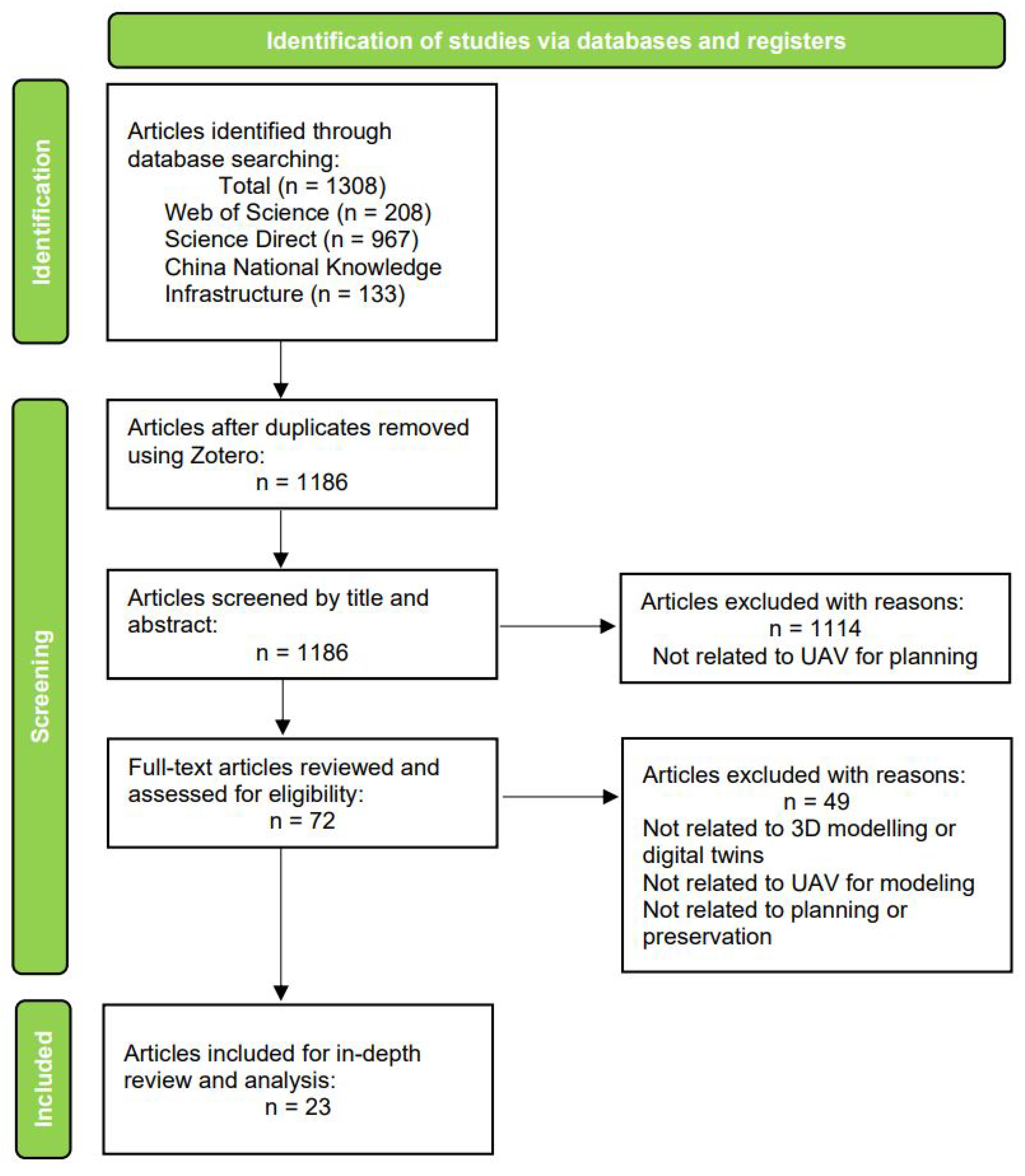
2.5. Study Selection

Initially, 1186 articles were identified and assessed based on their title and abstract. A substantial portion of these excluded articles demonstrated a technical orientation or focused on non-planning topics. Hence, 1114 articles were not related to UAV for planning, and as such were deemed irrelevant to our research and excluded. The remaining 72 articles underwent full-text screening; 49 of these did not meet the eligibility criteria, leaving 23 articles for inclusion in the final in-depth literature review. Figure 2 illustrates the search strategy, which complied with the PRISMA guidelines.
The study adhered to the guidelines outlined by the Preferred Reporting Items for Systematic Reviews and Meta-Analyses (PRISMA) for systematic literature reviews [25,26]. Our review followed the conditions outlined below. It was grounded in articles sourced from the Science Direct, Web of Science (WOS), and China National Knowledge Infrastructure (CNKI) repositories, published within the last two decades, and based on relevant keywords. We considered articles that incorporated the specified keywords within their titles, abstracts, or keyword sections for inclusion in our analysis. The search process was systematically executed using the search strings outlined in Figure 3. Our study selection process entailed keyword searches, de-duplication, and qualitative analysis through the examination of abstracts and keywords. We employed the VOSViewer tool for analysis of the retrieved articles, which involved a detailed review and keyword matching. To ensure the reliability of our findings, we compared them with those of other studies in order to identify consistencies. All of the studies included in our review were subject to the same set of rules. We have listed and defined all the outcomes for which data were sought, including any methods used to decide which results to collect. It is important to acknowledge that our specific selection criteria and the keyword-based article retrieval process may not have captured all published articles, reflecting the inherent limitations of the employed approach.

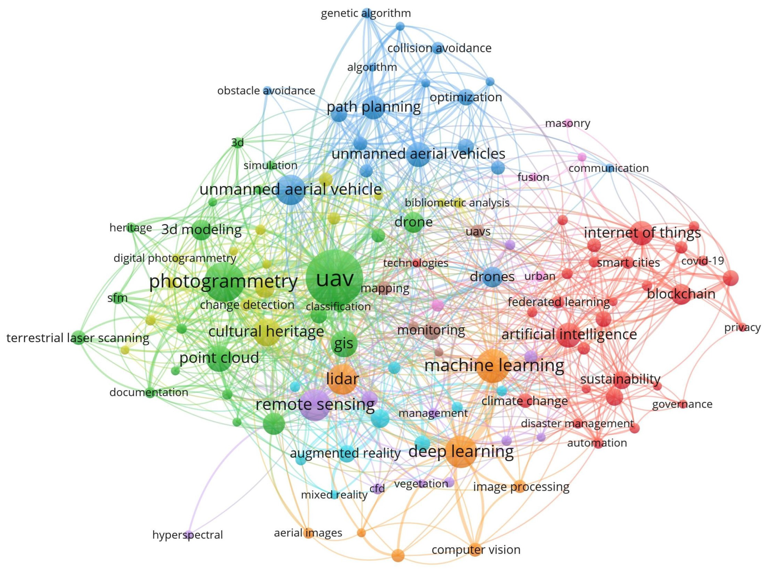
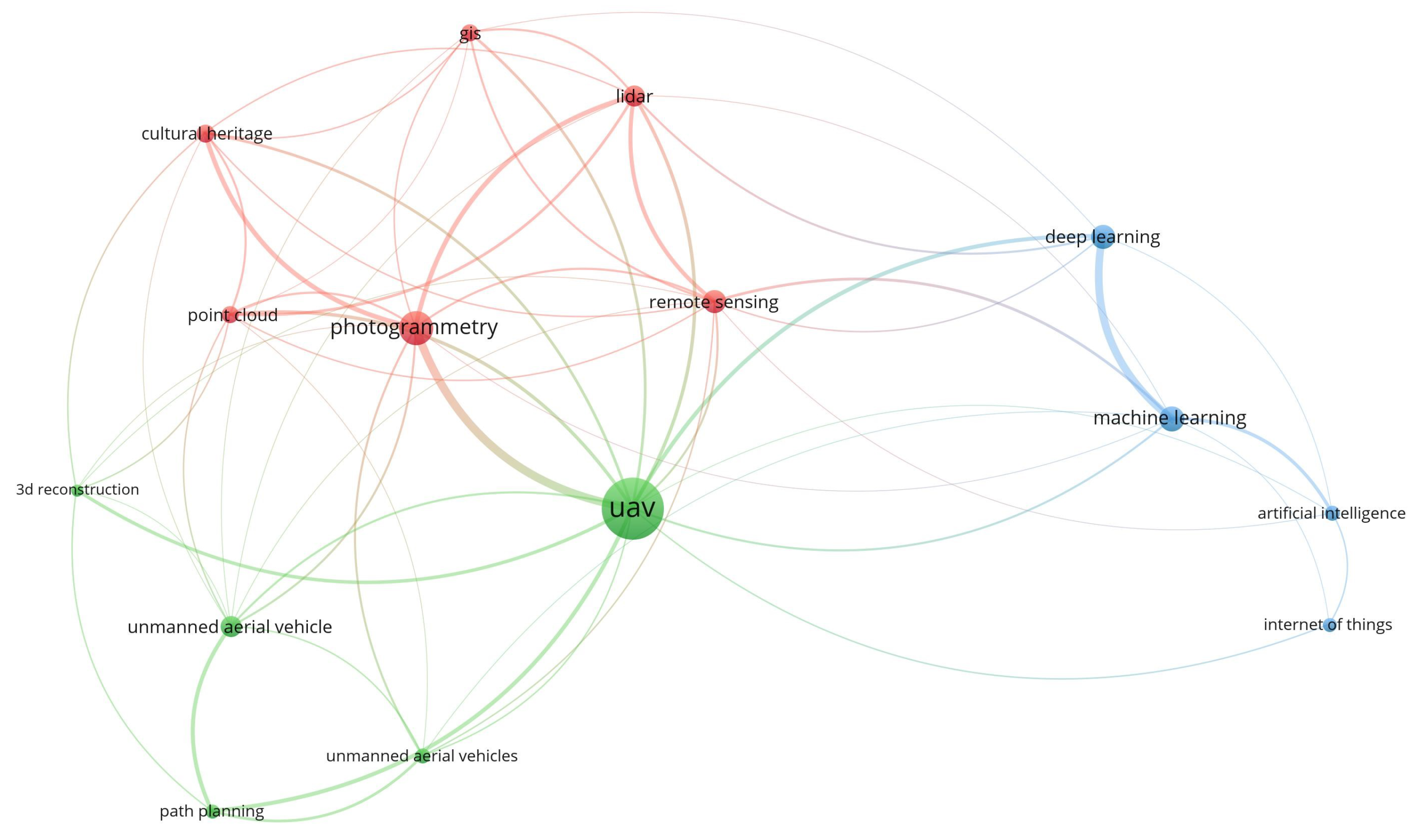
2.6. Analytical Framework

This study analyzed a subsection of research papers in order to address our guiding research questions relating to the use of UAVs in planning and preservation contexts and to the potential of 3D modeling and drone technology for enhancing research and practice in thse fields. In addition, the potential barriers and limitations that hinder the widespread use of UAV technology and suggested possible solutions to overcome these obstacles were analyzed as a means to encourage further research in this field.

3. Recent Studies on the Use of UAVs in Planning

The use of 3D modeling has been prevalent in various fields; at present, an expanding trend involves the utilization of 3D modeling technology in the preservation of historical sites [27,28,29,30]. However, the terms “drone”, “UAVs”, and “unmanned aerial vehicles” were not discovered during a search for articles published in the Journal of the American Planning Association, a flagship journal within the field of planning, since the year 2000. This highlights the limited scope of published scholarship in this specific area.
Moreover, a broader search of journals revealed that the use of UAVs in urban planning, particularly in relation to 3D modeling, is relatively restricted. However, an analysis of the recent literature output indicates a notable increase in UAV publications since 2015. It is worth noting that the Journal of Planning Education and Research issued a special call for urban digital twin papers in 2023. Although this call did not explicitly mention UAVs or drone technology, it is an example of the attention being paid to the prominence of 3D modeling technology in a journal that typically focuses less on the technical aspects of representing the built environment.
At present, it remains uncertain whether this call will generate examples showcasing the use of UAVs to enhance 3D models. However, it is possible that detailed, accurate, and honest representations of existing buildings could have ethical implications for the development of 3D models. As an example, researchers have pointed to the misrepresentation of buildings in the creation of digital 3D representations [31]. Drone photogrammetry might be a way to better represent cities in the way that they are actually built.

3.1. Overview of UAV Usage in Planning

The growing body of publications suggests that UAVs have gained increasing attention among researchers, showing that UAVs have been applied to more fields as an emerging remote sensing technology [32,33,34,35]. UAV usage can be seen in publications related to transportation planning, historic preservation, land use planning, park activity monitoring, and sustainability planning [36,37]. For example, Bhatnagar et al. [38] presented a new technique for mapping wetlands using drone imagery and satellite imagery with the aim of reducing the need for costly and time-consuming field surveys. The authors captured a small number of drone images and used them to train a classifier that was then applied to satellite imagery. In another study, Donaire et al. [39] explained how drones or UAVs can take zenith images without visitors’ direct participation while offering highly accurate spatial information. Their article outlines the methodology for utilizing drone imagery to perform a quantitative analysis of tourist behavior and travel routes in an urban setting, illustrating how drone images can be used to gain insights into travel patterns and crowd behavior. This can help urban planners to make better decisions and improve the visitor experience.
Despite the diversity of UAV research in the above fields, the use of UAVs for 3D modeling in urban planning has been largely overlooked. Our literature review revealed a scarcity of research papers that solely investigated the use of unmanned aerial vehicles (UAVs) for creating three-dimensional models and extracting practical information to aid urban planners in their decision-making processes. As a result, in this paper we aim to bridge this gap by conducting a comprehensive review of the topic and laying a foundation for future research on the application of UAVs in urban planning. Table 1 provides an overview of the existing planning literature on the use of UAVs in 3D modeling, highlighting the technologies used and future opportunities for research.

3.2. Main Application Analysis

One important application of UAV photogrammetry is damage assessment and reconstruction of cities [60]. Building destruction is a common byproduct of war and natural disaster. It is very often the case that original drawings and pictures that directly reflect the original appearance of the buildings cannot be found. Therefore, researchers can only use other materials to compare and restore them step by step. In this context, UAVs can be applied to a city’s post-war reconstruction; photogrammetry allows researchers to create highly accurate models of ancient buildings and antiquities, while 3D models provide comprehensive digital data for infrastructure repair. Remarkably, despite the evident potential of UAVs in this domain, there is a surprising lack of scholarly articles specifically addressing this application. Further research and exploration in this area could significantly enhance the understanding and utilization of UAV photogrammetry for urban reconstruction endeavors.
Several challenges have been encountered in the use of photogrammetry to preserve cultural heritage. Many ancient and older heritage buildings have often undergone significant structural and appearance changes due to weathering, and may be fragile, making surveying difficult. In addition, recording details such as carvings and colors require close-up observations, which can be challenging. The remote and complex locations of many ancient buildings pose difficulties when manually setting up surveying equipment. Direct contact with fragile historic sites and ancient buildings can cause irreversible damage. UAVs provide a safe and non-contact solution for surveying and mapping, potentially revolutionizing the digitization of cultural heritage protection. The use of UAVs not only has the potential to enhance 3D documentation for the preservation of cultural resources, it could translate into new modes of historical interpretation through enhancements to virtual reality and augmented reality.

3.3. Common Themes

A number of studies have focused on using UAVs to map and model cultural heritage objects, urban spaces, and disaster sites with the goal of preserving, managing, and reconstructing historical sites in the future. While several studies have discussed the advantages of oblique photogrammetry over vertical photogrammetry in achieving higher accuracy in mapping, others have emphasized the necessity of developing systems that incorporate advanced technologies, such as 360 ° cameras and LiDAR technology, in order to generate precise representations of real-world environments [61].
Among the articles that we reviewed, many have common themes; for example, Li, 2018 [41] demonstrated the application of UAV photogrammetry in urban and regional planning, while Erenoglu et al., 2018 [44] studied the use of UAV technology for 3D modeling in relation to urban planning. Zhang et al., 2022 [45] presented a drone system empowered with artificial intelligence for real-time 3D reconstruction. Kikuchi et al. [21] created a method for visualizing urban 3D models through an outdoor augmented reality digital twin approach that provides low latency between the controller and the augmented reality digital twin device. In the context of historical preservation, Kikuchi et al., 2022 [21], Tariq et al., 2017 [42], and Berrett et al., 2021 [43] all focused on creating 3D models of historical sites using UAV photogrammetry and other technologies. Karachaliou et al., 2019 [40] developed an HBIM model of a museum using UAV photogrammetry, while Tariq et al., 2017 [42] used UAV photogrammetry to produce 3D models of archeological sites in Pakistan. Berrett et al., 2021 [43] developed a hyper-realistic 3D model of a university campus in the USA using UAV techniques in combination with other technologies. Li, 2018 [41] and Erenoglu et al., 2018 [44] both aimed to investigate the accuracy of UAV-based 3D modeling in urban planning, while Zhang et al., 2021 [45] focused on developing a real-time 3D reconstruction system using UAV technology. Kikuchi et al., 2022 [21] developed an outdoor augmented reality digital twin approach for public participation in urban design decision-making processes.
Several studies have demonstrated the potential of UAV photogrammetry in creating realistic 3D models of historical buildings, with Tariq et al., 2017 [42] using photogrammetry to develop accurate 3D models of archaeological sites in Pakistan and Karachaliou et al., 2019 [40] using UAV photogrammetry to create an HBIM model of the Averof’s Museum of Neohellenic Art in Greece. Erenoglu et al., 2018 [44] further investigated the accuracy of UAV-based 3D modeling and found it to be reliable and adaptable to different 3D modeling applications.
A number of studies have explored the use of UAVs to aid in disaster response, including Ferworn et al., 2011 [49], who suggested the use of readily available hardware to develop a system that can capture aerial data on disaster sites and create 3D models, potentially enhancing the effectiveness of existing disaster response techniques and guidelines. Soulakellis et al., 2020 [62] examined and proved the feasibility of using drone-based Structure-from-Motion (SfM) methods to aid in post-earthquake recovery. Similarly, Zhang et al., 2022 [45] presented their development of an artificial intelligence-empowered drone system that achieves real-time 3D reconstruction, which could be used for practical applications for data analysis and decision-making.
Studies have shown that UAVs have great potential when combined with other technologies. Campbell, 2018 [46] demonstrated the use of drones, photogrammetry, and virtual reality (VR) in documenting and preserving cultural artifacts at the Lelu ruins in Micronesia. Additionally, a UAV system powered by artificial intelligence with the ability to perform real-time 3D reconstruction of urban cities was presented in [45]; using a combination of depth fusion and visual–inertial odometry, this system allows for improved 3D model quality and interactive navigation guidance.

3.4. Common Method and Model

The utilization of UAVs in urban planning and protection involves various methods, technologies, and models for image processing and modeling analysis. These methods contribute to the effectiveness and efficiency of UAV-based data collection and analysis.
Several key studies have highlighted the innovations in this field; for instance, one study presented a multi-UAV coverage path planning method for 3D reconstruction of post-disaster damaged buildings [63]. The methodology involved generating camera location points surrounding targeted damaged buildings, filtering and sorting these points, and optimizing routes to balance flight distance and time. The proposed method outperformed conventional overhead flight with the nadir-looking method, resulting in higher-quality 3D models. This study highlights the importance of UAVs along with their role in capturing high-resolution images and detailed information for assessing damage situations in specific areas.
The integration of OpenStreetMap (OSM) data with the Advanced Land Observing Satellite-2 World 3D-30 m (AW3D-30) digital surface model (DSM) has demonstrated substantial potential for scientific research, in particular due to the increasing size of OSM data and the global coverage of AW3D-30 [64]. This study emphasized the need for a global completeness assessment of OSM data in order to enhance its utility, acknowledging concerns about data quality, as OSM data are primarily contributed by non-professionals. Nonetheless, OSM remains a valuable source of 2D building data, especially in regions where authorized building data are not freely available.
In terms of data extraction and surface reconstruction, Pix4Dmapper software (version 4.8) is commonly used for transforming images collected by UAVs into various outputs, such as 3D point clouds, orthomosaics, and DSMs [47]. The software employs computer vision and photogrammetry techniques to process geo-tagged images and generate dense point clouds, 3D meshes, and textured models. Additionally, Blender (version 4.0), an open-source 3D render software, can be used to enhance the photorealism of 3D models generated by Pix4Dmapper. Blender enables texture mapping, lighting adjustments, denoising filters, and other rendering enhancements to produce high-quality visualizations.
Another study proposed a city-scale digital twin approach for future landscape visualization using AR and drones. The method involved rendering AR with occlusion handling, using a detailed city 3D model on a server PC using software such as Unity (version 2020.1.7) and Metashape (version 1.6.0), and integrating it with an AR device to generate both first-person and overhead views [21]. The IoU segmentation metric was used to evaluate the accuracy when handling occlusion. The proposed method can enable free AR viewpoints and multiple-stakeholder participation in urban design projects.
These examples demonstrate the ongoing technological innovations in image processing and modeling analysis for UAV-based urban planning and protection. The integration of OSM data with AW3D-30 DSM, multi-UAV coverage path planning methods, and advanced software tools such as Pix4Dmapper and Blender showcase the evolving capabilities and quantitative effects of UAV image processing and modeling. These advancements contribute to the generation of accurate and detailed spatial information, facilitating informed decision-making and planning in urban environments.

3.5. Critical Challenges and Notable Gaps in the Literature

Despite the progress made in UAV 3D modeling for planning and preservation, our comprehensive review of the literature has revealed five critical challenges and notable gaps that currently exist within the field. These findings indicate areas where further research and development are needed in order to fully realize the potential of UAV-based 3D modeling in urban and regional planning.
First, there is insufficient participation on the part of planning experts. One significant observation from our review is that a considerable number of articles focusing on the applications of UAV 3D modeling in planning-related fields were authored by scholars from disciplines other than urban and regional planning. This highlights a gap in the active engagement of urban planning professionals and researchers in the development and advancement of UAV-based 3D modeling techniques. The involvement of urban and regional planning experts is crucial to ensure that UAV 3D modeling aligns with the specific needs, goals, and challenges faced by urban areas. Urban planners possess valuable insights into the complexities of urban environments, including land use zoning regulations, infrastructure development, transportation systems, and community engagement. Their involvement in the research process can provide a more nuanced understanding of the urban planning context and contribute to the development of UAV-based 3D modeling techniques that directly address the unique requirements of urban and regional planning.
Second, there were imbalances in terms of the research focus. Urban planning is a systematic discipline that encompasses a wide range of subjects, including landscape, design, transportation, and the environment. Beyond the well-covered areas of historic preservation, landscape, and technical aspects, there is an evident lack of balance in the research focus within the existing literature. The insufficient attention paid to other crucial domains within urban planning, such as transportation, environmental sustainability, and design, represents a significant gap in the current UAV 3D modeling research. For instance, transportation plays a vital role in urban planning, as it directly impacts mobility, accessibility, and the overall functioning of cities. However, there is a scarcity of studies exploring the potential of UAV 3D modeling in optimizing transportation infrastructure, analyzing traffic patterns, and designing efficient transportation networks. Integrating UAV technology into transportation planning can provide valuable insights into traffic flow, pedestrian movement, and public transit systems, leading to more informed decision-making and improved urban mobility; hence, achieving a more comprehensive balance across these various disciplines could benefit urban planning and development. As another example, planning should play a crucial role in aiding cities in their climate change mitigation and adaptation efforts [65]. Detailed 3D models can be used to assess multiple land-use scenarios for adaptation purposes. Moreover, 3D models are useful in identifying high-impact areas for retrofitting building stock to reduce operational carbon [66], and can be useful in analyzing existing building stock as a way to better estimate the embodied carbon associated with building reuse and preservation or systematic deconstruction and reuse [66,67]. Whether planning for climate change mitigation or adaptation, high-resolution data collected using UAVs can assist in gathering and rendering fine-grained information about building materials and construction types in 3D.
Third, there appears to be a lack of research pairing UAVs with 3D models to respond to urban scenarios. With the increasing occurrence of natural disasters, wars, and conflicts in urban areas, there is a pressing need for research on UAV 3D modeling for urban disaster prevention and post-disaster reconstruction. However, the current literature does not adequately explore these specific scenarios. For example, UAV-based 3D modeling can contribute to the post-disaster reconstruction process by facilitating accurate damage assessment, guiding reconstruction efforts, and assisting in the planning and design of resilient infrastructure. One notable example is the work presented in [68], where the authors employed drone imagery and 3D models to assess post-earthquake damage in historical stone masonry buildings. The authors used computer vision, Structure-from-Motion, and machine learning to automate damage assessment, generating lightweight damage-augmented digital twins (DADTs) at LOD3 to eliminate the need for manual intervention and offer efficient storage solutions. The creation of detailed and up-to-date 3D models using UAV technology can enable urban planners and decision-makers to visualize the extent of damage, identify critical areas for intervention, and develop strategic plans for rebuilding safer and more resilient communities. Expanding the scope of the investigation to encompass disaster-resilient urban planning and reconstruction represents a way of contributing to more effective response and enhanced urban resilience.
Fourth, despite the growing importance of smart cities in urban development, we found little integration with the literature on smart cities. Smart cities aim to leverage advanced technologies to improve quality of life, enhance sustainability, and optimize resource utilization. However, the existing literature lacks in-depth research on the integration of UAV 3D modeling in smart city initiatives, particularly as concerns its incorporation with high-quality human life aspects such as smart transportation and public facilities. By capturing detailed 3D models of existing infrastructure and urban spaces, UAVs can aid in facility management, maintenance, and optimization. Exploring and harnessing the potential synergies between UAV 3D modeling and smart city planning is crucial for fostering innovation and efficiency in urban development.
Lastly, there was a lack of intersectionality with other disciplines. Urban planning is inherently multidisciplinary and interdisciplinary, requiring collaboration and knowledge exchange across various fields such as geography, engineering, and environmental science; however, the current literature does not sufficiently explore the intersection between UAV 3D modeling and these disciplines. Collaborations between urban planners, geographers, engineers, environmental scientists, social scientists, and other architects can enrich the understanding and practice of UAV 3D modeling in urban environments. Bridging these gaps and fostering interdisciplinary research efforts will lead to more comprehensive and robust approaches to urban planning, enriching the understanding and practice of UAV 3D modeling in urban environments.
Addressing these identified challenges and gaps in the reviewed articles is crucial for advancing UAV-based 3D modeling in urban environments. By striving for a more balanced research focus, incorporating special scenarios, fostering integration with smart city planning, and embracing interdisciplinary collaboration, future research can contribute to more inclusive, sustainable, and resilient urban development.
The following section builds upon the critical challenges and gaps identified above to explore the practical limitations and barriers of UAV 3D modeling in planning contexts. Understanding these limitations and barriers can help to address the practical challenges that hinder the integration of UAV 3D modeling in planning practice.

4. Existing Limitations and Barriers of UAV 3D Modeling for Planning

UAVs can be very useful in 3D modeling applications thanks to their ability to capture high-resolution imagery at a relatively low cost. However, despite their advantages, UAV-based 3D modeling has a number of limitations and barriers. Table 2 presents a summary of the significant limitations of UAV 3D modeling for planning.

4.1. Policy

The increasing public presence of UAVs has resulted in a wide variety of concerns among the public, a majority of which involve personal privacy [71,74]. Many recreational UAVs are equipped with zoom cameras and have been seen in residential areas and private properties without permission, leading to potential privacy issues. There are additional concerns regarding safety, noise, and privacy due to a lack of regulations [72]. Lack of regulation has led to safety concerns as well, as UAVs can distract drivers and cause car accidents in urban areas [70]. It has been found by the International Civil Aviation Organization (ICAO) that the motors, propellers, and airframe of UAVs can produce a significant amount of noise, which may be perceived as annoying to the public [72]. In addition, complex urban environments may interfere with the electronic signals and obstacle-sensing systems UAVs, potentially causing consequential incidents. For instance, when UAVs must fly in close proximity to buildings in the process of collecting data for 3D modeling, it is possible that wind, low-light conditions, glass and other reflective material on a building’s surface, or certain electronics may cause loss of control [14,48,75].
Various rules regulate the use of UAVs in different countries and cities. Cities such as New York City officially prohibit the use of UAVs within the urban environment [82]. The Federal Aviation Administration (FAA) has established guidelines to regulate the operation of UAVs, stipulating that they should not be flown over people and must remain within the pilot’s line of sight [83]. A specialized license or permit is mandatory for individuals to use a drone in a professional capacity in several countries, including the United States [84]. However, ensuring compliance with these policies can prove arduous, particularly during 3D modeling endeavors where UAVs must navigate through difficult-to-reach locations to aid researchers. As a result, individuals may be disinclined to register their UAVs, leading to a significant number of unregistered UAVs in operation.
Despite the FAA having created regulations regarding where pilots are allowed to operate UAVs, there are gaps on the no-fly zone map that need to be filled. To address this issue, the FAA should implement policies that request UAV pilots to use indicators to warn people in the area and notify the local government. UAV manufacturers and the FAA could develop a platform to identify UAVs in real-time and provide detailed information such as flight location, attitude, path and other geographic information as a way to help local governments inform individuals when necessary.
Cross-cultural communication is a critical aspect of working with teams in different regions of the world when operating UAVs, particularly when the project involves local historic preservation. In such situations, misunderstandings and delays in project completion can arise due to cultural differences [46]. To address this issue, researchers should incorporate cross-cultural communication training and education into their projects. Before conducting site analysis, researchers should carry translation devices to communicate with residents who speak a different language, and should seeking guidance from them to facilitate communication. This approach can promote cross-cultural understanding and cooperation, increasing the the research project’s likelihood of success. Prior to conducting site analysis, researchers should ensure that the residents are properly informed and engaged in the process. Researchers and practitioners should be particularly mindful when flying drones in areas that are culturally significant to indigenous people, and should seek out appropriate cultural protocols for asking permission while refraining from flying UAVs without prior permission being granted.

4.2. Environment

UAVs are not always stable and safe; they can cause security risks when flying near airports, electric power grids, and other areas with high population density. In the urban environment, UAVs may pose a threat to properties and human safety if an impact happens. The functioning of UAVs can be greatly affected by environmental factors. According to Hodgson and Chang [75], the line-of-sight and signal connections of UAVs can be affected by obstacles such as trees and low-light conditions. Another constraint on line-of-sight is the effect of obstacles such as trees, which can cause incomplete data collection and inaccurate modeling. Despite researchers developing strategies that use AI and overlap imaging to mitigate this problem, additional improvements remain necessary [48]. In addition, environmental factors such as high wind, hail, and rain can impact the stability of UAVs, as noted by Grubesic et al. [76] and Fairley et al. [77]. Weather is generally unpredictable, and researchers may encounter a variety of sudden environmental factors such as high wind, hail, and rain [78]. UAV signal transmission systems, Global Position System (GPS), and Inertial Measurement Unit (IMU) can be impacted while flying in the urban environment. When the GPS or IMU is compromised, UAVs manufactured by DJI are rendered unable to position themselves or brake automatically, and enter DJI ATTI Mode (Attitude Mode), which puts them in a manual mode that makes them susceptible to hazardous shifting even with a slight wind. When the signal is lost, UAVs may enter return-to-home mode; however, the obstacle avoidance system may not work in certain conditions, potentially leading to crashes [73].
It is our belief that advancements in UAV design and engineering can address the critical aspects of stability and resilience. It is crucial to focus on developing UAV structures that are stronger and more durable while being capable of withstanding adverse weather conditions. The integration of redundant systems and backup power sources alongside the implementation of improved communication protocols will play a pivotal role in enhancing reliability and ensuring safety. In addition to these measures, emerging technologies such as swarm intelligence and cooperative control systems offer promising solutions to address stability and safety concerns. These technologies can enable coordinated and collaborative operations among multiple UAVs, thereby mitigating the risks associated with individual failures and bolstering overall system resilience. By consistently advancing in areas such as sensor integration, design practices, and appropriate regulatory frameworks, UAVs can become more reliable and safe to operate efficiently in complex urban environments.

4.3. Disciplinary

Many of the studies that we identified focused on specific research projects related to planning and historic preservation. However, there are a number of barriers hindering the adoption of drone imagery and 3D models in the government offices responsible for overseeing planning and preservation efforts. These barriers are often rooted in disciplinary and institutional factors that impede the wider integration of UAV technologies in urban planning. One of the key disciplinary challenges lies in the different roles and responsibilities of planners and architects/engineers in the planning process. Planners, who assess applications for new development and make decisions based on urban planning principles, typically do not generate their own digital models or imagery; instead, they rely on architects and engineers to provide specialized information. As a result, there is often no requirement for enhanced 3D models from the planners’ perspective. This disconnect between the disciplines of planning and architecture/engineering hinders the seamless integration of UAV-derived data and 3D models into the planning workflow.
Furthermore, urban planning programs generally do not prioritize the teaching of Building Information Modeling (BIM) and 3D modeling skills, which are essential components of any architectural degree. Consequently, there is a shortage of planners with the necessary skills to create 3D models or process drone photogrammetry. This disciplinary gap contributes to the limited adoption of UAV technologies in government planning offices, as the personnel may lack the expertise and confidence to leverage these emerging tools effectively.
In addition to disciplinary challenges, institutional barriers exist within planning and preservation offices. Many of these offices have limited capacity to allocate personnel or invest in new technologies. Moreover, routine tasks such as tax assessment as well as long-range planning processes often rely more heavily on geographical information systems (GIS) tools than on drone imagery or 3D modeling. The lack of both human and financial resources further exacerbates the institutional obstacles to the wider adoption of these technologies.
To address these disciplinary and institutional challenges, establishing partnerships with universities is crucial. Universities often possess specialized technological capabilities and can contribute to bridging the gap between academia, government practice, and the non-governmental and private sectors. These collaborations can facilitate knowledge transfer, training programs, and capacity-building initiatives. Government offices and the private sectors can overcome shortages of skills and resources by leveraging the expertise and resources available in academia, thereby incorporating UAV technologies, digital twins, and drone imagery for improved planning and preservation outcomes.
Moreover, university–government partnerships provide a platform for joint research projects on which academics and practitioners can collaborate to develop innovative solutions tailored to the needs of urban planning and historical preservation. These partnerships can help to generate evidence-based best practices, develop standardized workflows, and establish guidelines for the effective utilization of UAV technologies. Additionally, universities can contribute to the training and education of future planners by incorporating UAV technologies and 3D modeling into urban planning programs when preparing new generations of professionals with the necessary skills to utilize these tools effectively.

4.4. Hardware

The operation of UAVs is limited by battery capacity and by environmental factors such as wind and temperature [37]. UAV manufacturers have been working to increase flight time without sacrificing payload; for example, better aerodynamic propeller designs can be adopted to provide extended flight time [85]. In practice, the flight time of UAVs typically does not exceed 60 min. As an example, DJI’s newest maximum flight time UAV is the MATRICE 300 RTK, which can reach a flight time of up to 55 min without a payload. However, the actual flight time varies, and could be as low as 20–35 min per mission when equipped with a Lidar + RGB aerial surveying camera (Zenmuse L1) [86]. In the meantime, the UAV’s actual flight time may be affected by environmental and load conditions [70]. In addition, longer charge cycles and storage times lead to reduced battery life, while flying at higher altitudes and in warmer air can decrease the flight time of a UAV, resulting in unstable and unpredictable flight durations [6,24,79]. Notably, 3D modeling and tilt photography commonly require more than an hour of workload, and changing the battery during shooting is not preferred.
In addition, RTK-enabled GPS systems provide centimeter-level accuracy and precision in positioning data, which is essential for creating high-quality 3D models [76,80,81]. Without RTK, UAVs must rely on traditional GPS systems that provide only meter-level accuracy. This level of accuracy may not be sufficient for creating detailed and accurate 3D models. As RTK systems are more expensive than traditional GPS systems, cost can be a significant barrier for both UAV manufacturers and researchers. Thus, the limitations of battery life and RTK availability represent significant challenges for the advancement of UAVs in urban planning.
Optimizing aerodynamic designs and propulsion systems can extend flight time without sacrificing payload capacity. Additionally, advancements in battery technology, such as increased energy density and faster charging capabilities, need to be pursued in order to enhance UAV endurance. Future innovations might involve the integration of alternative power sources such as solar panels or the development of smart power management systems to optimize energy usage. The adoption of RTK-enabled GPS systems provides the centimeter-level precision necessary for high-quality 3D modeling. Continued research and development efforts can lead to more cost-effective RTK solutions or to alternative positioning technologies offering similar accuracy at lower cost.

4.5. Software

One major limitation of UAV 3D modeling is the requirement for a dependable and high-bandwidth internet connection. The transmission of data from the UAV to the ground station demands substantial bandwidth, and interruptions in internet connectivity can hinder the timely uploading of critical data, potentially leading to the loss of vital information [46]. Additionally, the process of generating 3D models entails a complex computational system and often necessitates specialized technical expertise. According to the articles we reviewed, the most commonly used 3D modeling software programs for UAVs consist of commercial solutions such as Pix4D and Agisoft PhotoScan/Metashape. However, it is essential to recognize that these software packages can come with expensive licensing fees, and they may require high-end graphics cards for efficient image processing [47,48].
To overcome internet connectivity challenges, advancements in data compression techniques can reduce the bandwidth requirements when transmitting UAV data. Additionally, the use of onboard processing capabilities can alleviate reliance on real-time data transmission, enabling UAVs to process and store data locally until it can be transferred when a stable internet connection becomes available.
In terms of software limitations, it is anticipated that ongoing technological progress will enhance the accessibility of 3D modeling using UAVs. The costs associated with high-end graphics cards and professional modeling software may gradually decrease, making them more cost-effective for researchers and planners alike. In the foreseeable future, the advent of cloud-based solutions for UAV data processing and modeling is expected. Such solutions would shift the computational workload to robust remote servers, negating the need for expensive processing systems on the user’s end. Additionally, the development of user-friendly software interfaces and increased availability of training courses should streamline the 3D modeling process.
It is essential to acknowledge that the landscape of available software extends well beyond commercial options. Researchers in fields such as computer vision frequently turn to open-source alternatives such as COLMAP, VisualSFM, and Meshroom [87,88]. While these open-source tools may not deliver the same level of optimization as their commercial counterparts, they furnish potent resources for crafting innovative methodologies, particularly those essential for generating 3D models.
Additionally, advancements in machine learning and artificial intelligence can assist in automating tasks such as feature extraction, image alignment, and model generation, thereby reducing the need for manual intervention and specialized technical knowledge. In response to the critical need for automating image acquisition in UAV-based infrastructure inspections, researchers have been actively developing autonomous navigation planning systems. These systems leverage computer vision techniques and deep learning algorithms to enable UAVs to autonomously capture images suitable for 3D modeling. One promising application focuses on post-earthquake inspections of reinforced concrete railway viaducts; this approach offers a solution to the time-consuming manual operation of image acquisition, achieving centimeter-level accuracy in detecting critical structural components such as columns and allowing UAVs to progressively improve their mapping as more views are captured during the inspection [89]. Another study introduced an automated framework for recognizing bridge components using UAV imagery and 3D point clouds, resulting in significantly improved classification accuracy [90]. A third paper in this research area proposed a computer vision-based framework for automating post-earthquake building inspections with UAVs, offering high accuracy in damage identification and assessment [91]. These advancements are expected to reduce the cost of professional modeling software, making large-scale modeling more accessible for researchers and planners.

5. Discussions

UAV technology could play a more central role in urban planning and historic preservation practice, especially in the use of UAVs to enhance the creation of 3D models. The lidar and RGB sensors of UAVs are particularly effective for 3D city modeling, assessing infrastructure height and area size, and obtaining real-time data as a new aerial surveying tool. The application of the UAV 3D information model for urban planning is an important branch of UAV technology application.
This paper provides a comprehensive systematic review and analysis of the current and potential applications of UAVs in urban and regional planning and historic preservation while addressing the existing limitations. Despite the promising opportunities offered by UAV technology, its effective use in urban planning is hindered by various factors, including institutional and disciplinary barriers related to the adoption of 3D modeling and drone imagery. Additionally, limited endurance, stability, safety concerns, and regulatory variations pose further challenges. The complexity of 3D modeling and image processing adds to the difficulties faced in leveraging UAVs for urban planning purposes. To overcome these limitations and fully harness the potential of UAVs in urban planning, it is imperative to establish interdisciplinary collaborations and forge partnerships between universities and government entities. Unlike university–enterprise partnerships, which primarily focus on commercial applications, university–government collaborations prioritize research, technical support, and the development of tailored solutions specific to the requirements of planning and preservation offices. These partnerships offer the unique advantage of combining academic expertise and resources with the practical needs and insights of government planning offices. By fostering these collaborations and enhancing integration between technologies, the advantages of UAV technology can be effectively utilized to elevate the quality of urban planning work. In this context, researchers play a pivotal role in promoting the further development of UAV technology and providing essential technical support for urban planning and construction.
In spite of the limitations mentioned above, UAVs have great potential to confer significant advantages over ground-based surveying and modeling technologies, including low cost, high accuracy, real-time creation of images, and time efficiency. In addition to taking over the role of aerial photography, UAVs could eventually replace traditional airplane or satellite aerial photogrammetry for small and mid-size neighborhood planning. UAVs have the potential to perform intelligent data processing in real time, leading to a reduction in both measurement time and cost. This can in turn improve the cost-effectiveness of UAV aerial photography in urban planning. The obtained three-dimensional data can vividly reflect a planning area’s appearance, position, height and other attributes, compensating for the low-level defects of traditional artificial modeling and simulation. In addition, UAVs can obtain more comprehensive surface texture detail and facilitate spatial analysis of the building area ratio, building density, and sunlight in three-dimensional models, thereby facilitating more accurate design and construction, effectively avoiding reconstruction, and shortening construction times [92]. The main functions of UAV 3D modeling are laid out below.
Smart city initiatives are a major area where UAV 3D modeling can be used. The models created by UAVs provide an in-depth view of the built environment, including the precise location and spatial arrangement of buildings, roads, and infrastructure elements [7,27,93,94]. This information is critical to decision-makers tasked with planning and managing urban growth in a sustainable and efficient manner. The data serves multiple purposes, enabling decision-makers to visualize and analyze the existing urban infrastructure, identify patterns and trends, and make informed decisions regarding urban growth and development. The resulting detailed 3D models provide a comprehensive view of the urban environment, facilitating the assessment of infrastructure capacity, traffic flow, and resource allocation. Furthermore, the data derived from UAV 3D modeling can be integrated with other data sources, such as geographic information systems (GIS) and sensor networks, to create comprehensive and dynamic digital representations of cities. These integrated data can then be used for various applications, including urban simulations, scenario modeling, and predictive analysis, leading to more optimal resource utilization, enhanced urban mobility, and improved overall urban livability.
In addition to smart city planning, UAV 3D modeling could play an even more expansive role in historic preservation than it already does. By surveying and mapping historic landmarks and buildings, UAVs can provide valuable information to urban planners and heritage organizations. This information can be used to guide preservation efforts and ensure that a city’s cultural heritage is preserved for future generations. For instance, 3D models of historical sites captured by UAVs can be imported into gaming or rendering software such as Unity, Blender, Unreal Engine, Lumion, and Twinmotion. Such integration allows for the creation of immersive and visually engaging first-person virtual reality (VR) mini-games. These VR experiences can be utilized as educational tools to engage and motivate youth and students, fostering their interest in learning more about historical sites. By exploring the site virtually, participants can gain a deeper understanding of its significance and cultural value. Moreover, the use of UAV 3D models in gaming or rendering software can assist planners in better understanding different sites. By visualizing historical structures and their surroundings in a virtual environment, planners can assess the site’s potential for adaptive reuse or repurposing. This technology enables planners to identify opportunities for integrating historical buildings into contemporary urban contexts while considering sustainable practices; moreover, 3D models may aid in identifying materials suitable for reuse, contributing to sustainable construction practices and reducing environmental impact.
Another important area where UAV 3D modeling finds use is in environmental impact assessment [77]. By surveying and assessing the impact of new development projects on the natural environment, UAVs can provide valuable information to urban and regional planners. Detailed 3D models aid in visualizing ecosystem impacts and analyzing land use, vegetation, water bodies, and wildlife habitats. This data-driven approach helps identify sensitive areas, mitigate negative effects, and promote responsible urban development. UAVs can be used evaluate conservation efforts, track changes over time, and enhance transparency and public engagement through visual representations of potential impacts.
An additional context in which we believe that the utilization of UAV 3D technology holds significant value is post-war urban rebuilding efforts. In the aftermath of wars, cities often face intricate challenges in assessing and measuring the damage to urban landscapes, making it challenging to plan reconstruction effectively. In such contexts, UAVs equipped with 3D imaging capabilities emerge as a valuable solution. They can capture high-precision aerial imagery and generate detailed 3D maps, aiding urban planners and architects in obtaining a comprehensive understanding of post-war conditions in affected areas. This information becomes instrumental in devising strategies for the global-level rebuilding of damaged cities. The high-resolution imagery and precise 3D models produced by UAVs empower planners to visualize the extent of damage, prioritize areas that need immediate attention, and allocate resources strategically for maximum impact. By extending the application of UAV 3D technology beyond specific regions, its potential can be harnessed to aid in post-war reconstruction efforts worldwide, thereby contributing to the revitalization and resilience of communities affected by conflicts.

6. Conclusions

The literature highlights a significant disparity in the use of UAVs between enhancing 3D city modeling in cultural heritage and historic preservation on the one hand versus urban planning on the other. Urban planning can benefit from the expertise of heritage professionals, who have long been concerned with the representation and analysis of the built environment. Furthermore, even within preservation practice there is room for expanding the utilization of UAVs and 3D modeling. Both disciplines face urgent challenges related to climate change and disaster response. Preservationists and planners share common concerns regarding properties located in coastal hazard zones, fire-prone areas, and other climate change-related threats. Drone photogrammetry can enhance the resolution of urban representations, enabling more effective scenario planning and citizen engagement. This technology can aid in identifying and protecting elements of the built environment that are at risk. Moreover, it can contribute to climate mitigation efforts by facilitating better estimation of areas with high solar potential and identifying locations for conserving operational and embodied energy on a larger scale. By leveraging UAVs and 3D modeling, urban planning can learn valuable lessons from heritage experts and address pressing climate change imperatives. Collaborative efforts between these fields hold the potential to create more resilient and sustainable urban environments.
Finally, UAV 3D modeling plays a critical role in disaster response and management. During times of natural disasters, UAVs equipped with 3D modeling capabilities provide real-time information about the built environment. These data assist urban and regional planners in making informed decisions to respond effectively and efficiently. The dynamic and up-to-date 3D models created by UAVs can help to identify potential hazards, locate survivors, and plan rescue operations accordingly. The applications of UAV 3D modeling technology extend beyond immediate response efforts, as it can be utilized for infrastructure planning and design as well. Real-time 3D models offer insights into the built environment, enabling planners to optimize the placement of essential facilities, transportation networks, and utilities, leading to the development of more resilient and efficient infrastructure systems in disaster-prone areas. The visual representations provided by UAV 3D modeling technology can assist in raising public awareness and supporting decision-making processes, while detailed and realistic 3D models can help to communicate the scale and impact of damage related to war or disaster to the general public and decision-makers.

7. Future Prospects

We believe that integrating UAVs and 3D modeling technology into urban and regional planning will have a profound impact on the field. In this context, the future prospects for UAV 3D modeling are both numerous and exciting, especially considering the aforementioned real-world projects using UAVs equipped with high-resolution cameras to create detailed 3D models of the built environment. We believe UAV 3D modeling could be transformative for planning practice as well as for the planning support systems that planners rely upon. By creating highly detailed 3D models of cities, UAVs can provide planners with valuable insights and data to inform a wide range of initiatives. From smart city planning to historic preservation efforts and disaster response and management, 3D UAV modeling could prove to be an indispensable tool for visualizing and analyzing cities.
We propose an area of exploration that involves the integration of quadruped robots with drones to create advanced 3D models. By equipping both robots and drones with LiDAR scanners and cameras, it becomes possible to capture high-quality 3D data from both aerial and ground perspectives as well as within indoor environments. This integration has the potential to enhance virtual reality (VR) experiences by providing a more immersive representation of the built environment. Additionally, the combination of data obtained from robots and drones allows for cross-validation, leading to more accurate and reliable results. This approach significantly improves the quality and precision of 3D models, enabling more informed decision-making and more streamlined urban planning processes. The merging of robots and drones holds great promise for the future of UAV-based 3D modeling, and has the potential to revolutionize the field. Further research and development in this area can be expected to unlock new possibilities for capturing comprehensive and detailed representations of urban environments.
In summary, the use of UAV 3D modeling in urban planning is currently providing valuable insights and data that inform a wide range of initiatives, from smart city planning to historical preservation. As the related technologies continue to advance and become more accessible, we expect UAV 3D modeling to become an even more important tool for urban and regional planners over the next decade. Despite the extensive literature on the topic, significant research gaps persist in the planning field. Notably, there is a lack of studies regarding rapid UAV 3D modeling; for instance, emergency situations require planners to be able to complete site data collection and post-modeling as soon as possible in order to aid in emergency response, making it necessary to examine the actual flight time and flight area ratio as well as the computer system specifications and modeling time. Thus, we urge scholars to expand the application domain, address the outstanding limitations, and scrutinize the integration of UAV 3D modeling with other disciplines, such as by integrating UAV 3D modeling with AI and ground robots, environmental science, and architecture, as a way to foster the creation of more sustainable cities.
In our future research, we are committed to addressing the critical research gaps discussed above, with a particular focus on rapid UAV 3D modeling and its seamless integration with cutting-edge technologies such as AI and robotics. These efforts aim to advance the field by pioneering novel methodologies and solutions, enhancing the capabilities of UAV 3D modeling in urban and regional planning, and ultimately promoting the development of more sustainable and resilient cities. Furthermore, we plan to venture into the realm of urban simulation, harnessing the power of gaming engines such as Unreal Engine and Unity. Their objective is to import drone data into these engines to craft immersive and visually stunning virtual city simulations. This innovative approach serves as a dynamic platform for urban planning as well as for educational purposes and public engagement. By merging the precision of UAV 3D modeling with gaming technology, such simulations offer potent tools for gaining deeper insights into urban complexities and facilitating informed planning decisions. This integration of urban simulation with UAV 3D modeling and other advanced technologies represents a crucial step toward more enlightened and sustainable urban development, a path that we are committed to exploring in our future studies.

Author Contributions

Conceptualization, D.H. and J.M.; methodology, D.H.; software, D.H.; writing—original draft preparation, D.H.; writing—review and editing, D.H. and J.M.; visualization, D.H.; supervision, J.M. All authors have read and agreed to the published version of the manuscript.

Funding

This research received no external funding.

Data Availability Statement

Not applicable.

Acknowledgments

This project received generous support from the Cornell University College of Architecture, Art, and Planning; the Department of City and Regional Planning; and the Clarence Stein Institute for Urban and Landscape Studies.

Conflicts of Interest

The authors declare no conflict of interest.

References

  1. Hostert, P. Advances in Urban Remote Sensing: Examples From Berlin (Germany). In Applied Remote Sensing for Urban Planning, Governance and Sustainability; Netzband, M., Stefanov, W.L., Redman, C., Eds.; Springer: Berlin/Heidelberg, Germany, 2007; pp. 37–51. [Google Scholar] [CrossRef]
  2. Bakogiannis, E.; Kyriakidis, C.; Zafeiris, V. Using Unmanned Aerial Vehicles (UAVs) to Analyze the Urban Environment. Eur. J. Form. Sci. Eng. 2022, 5, 49–60. [Google Scholar] [CrossRef]
  3. de Castro, A.I.; Shi, Y.; Maja, J.M.; Peña, J.M. UAVs for Vegetation Monitoring: Overview and Recent Scientific Contributions. Remote Sens. 2021, 13, 2139. [Google Scholar] [CrossRef]
  4. Zhang, H.; Wang, L.; Tian, T.; Yin, J. A Review of Unmanned Aerial Vehicle Low-Altitude Remote Sensing (UAV-LARS) Use in Agricultural Monitoring in China. Remote Sens. 2021, 13, 1221. [Google Scholar] [CrossRef]
  5. Kleinschroth, F.; Banda, K.; Zimba, H.; Dondeyne, S.; Nyambe, I.; Spratley, S.; Winton, R.S. Drone imagery to create a common understanding of landscapes. Landsc. Urban Plan. 2022, 228, 104571. [Google Scholar] [CrossRef]
  6. Shakhatreh, H.; Sawalmeh, A.H.; Al-Fuqaha, A.; Dou, Z.; Almaita, E.; Khalil, I.; Othman, N.S.; Khreishah, A.; Guizani, M. Unmanned Aerial Vehicles (UAVs): A Survey on Civil Applications and Key Research Challenges. IEEE Access 2019, 7, 48572–48634. [Google Scholar] [CrossRef]
  7. Tan, R.; Li, P.; Lin, W.; Pan, C. Improvement of 3D Urban Modeling Method Based on Unmanned Aerial Vehicle Oblique Photography. Bull. Surv. Mapp. 2016, 11, 39–42. [Google Scholar]
  8. Herwitz, S.; Johnson, L.; Dunagan, S.; Higgins, R.; Sullivan, D.; Zheng, J.; Lobitz, B.; Leung, J.; Gallmeyer, B.; Aoyagi, M.; et al. Imaging from an unmanned aerial vehicle: Agricultural surveillance and decision support. Comput. Electron. Agric. 2004, 44, 49–61. [Google Scholar] [CrossRef]
  9. Yao, H.; Qin, R.; Chen, X. Unmanned Aerial Vehicle for Remote Sensing Applications—A Review. Remote Sens. 2019, 11, 1443. [Google Scholar] [CrossRef]
  10. Allouche, M. The integration of UAVs in airspace. Air Space Eur. 2000, 2, 101–104. [Google Scholar] [CrossRef]
  11. Yang, Y.; Zhang, L.; Ye, Y.; Wang, Z. Curbing Sprawl with Development-limiting Boundaries in Urban China: A Review of Literature. J. Plan. Lit. 2020, 35, 25–40. [Google Scholar] [CrossRef]
  12. Watts, A.C.; Ambrosia, V.G.; Hinkley, E.A. Unmanned Aircraft Systems in Remote Sensing and Scientific Research: Classification and Considerations of Use. Remote Sens. 2012, 4, 1671–1692. [Google Scholar] [CrossRef]
  13. Lienard, J.; Vogs, A.; Gatziolis, D.; Strigul, N. Embedded, real-time UAV control for improved, image-based 3D scene reconstrucion. Measurement 2016, 81, 264–269. [Google Scholar] [CrossRef]
  14. Gatziolis, D.; Lienard, J.F.; Vogs, A.; Strigul, N.S. 3D tree dimensionality assessment using photogrammetry and small unmanned aerial vehicles. PLoS ONE 2015, 10, e0137765. [Google Scholar] [CrossRef] [PubMed]
  15. Alsadik, B.; Gerke, M.; Vosselman, G. Automated camera network design for 3D modeling of cultural heritage objects. J. Cult. Herit. 2013, 14, 515–526. [Google Scholar] [CrossRef]
  16. Westoby, M.; Brasington, J.; Glasser, N.; Hambrey, M.; Reynolds, J. ‘Structure-from-Motion’ photogrammetry: A low-cost, effective tool for geoscience applications. Geomorphology 2012, 179, 300–314. [Google Scholar] [CrossRef]
  17. Musakwa, W.; van Niekerk, A. Earth Observation for Sustainable Urban Planning in Developing Countries: Needs, Trends, and Future Directions. J. Plan. Lit. 2015, 30, 149–160. [Google Scholar] [CrossRef]
  18. Lu, Y. Using Google Street View to investigate the association between street greenery and physical activity. Landsc. Urban Plan. 2019, 191, 103435. [Google Scholar] [CrossRef]
  19. Li, X.; Chen, X. Research on 3D modeling method of geological section based on UAV Aerial Photography. Sci. Technol. Innov. 2021, 9, 55–56. [Google Scholar]
  20. Wan, D. Research on the Application Practice of UAV in Urban Planning Measurement. Manag. Technol. SME 2021, 660, 188–190. [Google Scholar]
  21. Kikuchi, N.; Fukuda, T.; Yabuki, N. Future landscape visualization using a city digital twin: Integration of augmented reality and drones with implementation of 3D model-based occlusion handling. J. Comput. Des. Eng. 2022, 9, 837–856. [Google Scholar] [CrossRef]
  22. Zhang, B.; Zhang, L. Study on the application of 3D modeling based on UAV photography in urban planning—Taking Yi Jiequ area in Du Jiangyan as an example. AIP Conf. Proc. 2017, 1864, 020226. [Google Scholar] [CrossRef]
  23. El-Mekawy, M.; Hijazi, I. 3D City Modelling and Remote Sensing: Advances, Challenges, and New Technologies [Special Issue]. 2023. Available online: https://www.mdpi.com/journal/remotesensing/special_issues/3D_modelling_remote_sensin (accessed on 17 November 2023).
  24. Butila, E.V.; Boboc, R.G. Urban Traffic Monitoring and Analysis Using Unmanned Aerial Vehicles (UAVs): A Systematic Literature 1008 Review. Remote Sens. 2022, 14, 620. [Google Scholar] [CrossRef]
  25. Moher, D.; Liberati, A.; Tetzlaff, J.; Altman, D.G.; Group, T.P. Preferred Reporting Items for Systematic Reviews and Meta-Analyses: The PRISMA Statement. PLoS Med. 2009, 6, e1000097. [Google Scholar] [CrossRef] [PubMed]
  26. Ullah, F.; Qayyum, S.; Thaheem, M.J.; Al-Turjman, F.; Sepasgozar, S.M.E. Risk management in sustainable smart cities governance: A TOE framework. Technol. Forecast. Soc. Chang. 2021, 167, 120743. [Google Scholar] [CrossRef]
  27. Hurtado, P.; Gomez, A. Smart City Digital Twins Are a New, Hi-Tech Tool for Scenario Planning. Am. Plan. Assoc. 2021. Available online: https://www.planning.org/planning/2021/spring/smart-city-digital-twins-are-a-new-tool-for-scenario-planning/ (accessed on 11 January 2012).
  28. Minner, J.; Chusid, J. Time, Architecture, and Geography: Modeling the Past and Future of Cultural Landscapes. APT Bull. 2016, 47, 49–58. [Google Scholar]
  29. Minner, J.; Chusid, J.; Shi, X.; Feng, Y.; Sun, F.; Azel, N.; Taru, T. Visualizing the Past, Present, and Future of New York City’s 1964–1965 World’s Fair Site Using 3D GIS and Procedural Modeling. Report published for National Center for Preservation Technology and Training. Cell 2017, 607, 4004. [Google Scholar] [CrossRef]
  30. Bobylev, N.; Syrbe, R.U.; Wende, W. Geosystem services in urban planning. Sustain. Cities Soc. 2022, 85, 104041. [Google Scholar] [CrossRef]
  31. Garstki, K. Virtual representation: The production of 3d digital artifacts. J. Archaeol. Method Theory 2017, 24, 726–750. [Google Scholar] [CrossRef]
  32. Deng, L.; Mao, Z.; Li, X.; Hu, Z.; Duan, F.; Yan, Y. UAV-based multispectral remote sensing for precision agriculture: A comparison between different cameras. ISPRS J. Photogramm. Remote Sens. 2018, 146, 124–136. [Google Scholar] [CrossRef]
  33. Maes, W.H.; Steppe, K. Perspectives for Remote Sensing with Unmanned Aerial Vehicles in Precision Agriculture. Trends Plant Sci. 2019, 24, 152–164. [Google Scholar] [CrossRef] [PubMed]
  34. Messina, G.; Modica, G. Applications of UAV Thermal Imagery in Precision Agriculture: State of the Art and Future Research Outlook. Remote Sens. 2020, 12, 1491. [Google Scholar] [CrossRef]
  35. Rejeb, A.; Abdollahi, A.; Rejeb, K.; Treiblmaier, H. Drones in agriculture: A review and bibliometric analysis. Comput. Electron. Agric. 2022, 198, 107017. [Google Scholar] [CrossRef]
  36. Yunus, A.M.; Hamzah, A.H.; Azmi, F.A.M. Drone Technology as A Modern Tool in Monitoring the Rural-Urban Development. IOP Conf. Ser. Earth Environ. Sci. 2020, 540, 012076. [Google Scholar] [CrossRef]
  37. Kim, D. Pedestrian and Bicycle Volume Data Collection Using Drone Technology. J. Urban Technol. 2020, 27, 45–60. [Google Scholar] [CrossRef]
  38. Bhatnagar, S.; Gill, L.; Regan, S.; Waldren, S.; Ghosh, B. A nested drone-satellite approach to monitoring the ecological conditions of wetlands. ISPRS J. Photogramm. Remote Sens. 2021, 174, 151–165. [Google Scholar] [CrossRef]
  39. Donaire, J.A.; Galí, N.; Gulisova, B. Tracking visitors in crowded spaces using zenith images: Drones and time-lapse. Tour. Manag. Perspect. 2020, 35, 100680. [Google Scholar] [CrossRef]
  40. Karachaliou, E.; Georgiou, E.; Psaltis, D.; Stylianidis, E. UAV for mapping historic buildings: From 3d modelling to bim. Int. Arch. Photogramm. Remote Sens. Spat. Inf. Sci. 2019, XLII-2/W9, 397–402. [Google Scholar] [CrossRef]
  41. Li, Y. UAV Photogrammetry and its Application in Urban Planning. Metall. Mater. 2018, 38, 181–182. [Google Scholar]
  42. Tariq, A.; Gillani, S.M.O.A.; Qureshi, H.K.; Haneef, I. Heritage preservation using aerial imagery from light weight low cost Unmanned Aerial Vehicle (UAV). In Proceedings of the 2017 International Conference on Communication Technologies (ComTech), Rawalpindi, Pakistan, 19–21 April 2017; pp. 201–205. [Google Scholar] [CrossRef]
  43. Berrett, B.E.; Vernon, C.A.; Beckstrand, H.; Pollei, M.; Markert, K.; Franke, K.W.; Hedengren, J.D. Large-Scale Reality Modeling of a University Campus Using Combined UAV and Terrestrial Photogrammetry for Historical Preservation and Practical Use. Drones 2021, 5, 136. [Google Scholar] [CrossRef]
  44. Erenoglu, R.; Erenoglu, O.; Arslan, N. Accuracy Assessment of Low Cost UAV Based City Modelling for Urban Planning. Teh. Vjesn. 2018, 25, 1708–1714. [Google Scholar] [CrossRef]
  45. Zhang, D.; Xu, F.; Pun, C.M.; Yang, Y.; Lan, R.; Wang, L.; Li, Y.; Gao, H. Virtual Reality Aided High-Quality 3D Reconstruction by Remote Drones. ACM Trans. Internet Technol. 2021, 22, 3458930. [Google Scholar] [CrossRef]
  46. Campbell, D.A. Drones, Machetes, and Virtual Reality: 21st-Century Tools for Historic Preservation. In Proceedings of the 2018 3rd Digital Heritage International Congress (DigitalHERITAGE) held jointly with 2018 24th International Conference on Virtual Systems & Multimedia (VSMM 2018), San Francisco, CA, USA, 26–30 October 2018; pp. 1–4. [Google Scholar] [CrossRef]
  47. Skondras, A.; Karachaliou, E.; Tavantzis, I.; Tokas, N.; Valari, E.; Skalidi, I.; Bouvet, G.A.; Stylianidis, E. UAV Mapping and 3D Modeling as a Tool for Promotion and Management of the Urban Space. Drones 2022, 6, 115. [Google Scholar] [CrossRef]
  48. Xu, Z.; Wu, L.; Gerke, M.; Wang, R.; Yang, H. Skeletal camera network embedded structure-from-motion for 3D scene reconstruction from UAV images. ISPRS J. Photogramm. Remote Sens. 2016, 121, 113–127. [Google Scholar] [CrossRef]
  49. Ferworn, A.; Tran, J.; Ufkes, A.; D’Souza, A. Initial experiments on 3D modeling of complex disaster environments using unmanned aerial vehicles. In Proceedings of the 2011 IEEE International Symposium on Safety, Security, and Rescue Robotics, Kyoto, Japan, 1–5 November 2011; pp. 167–171. [Google Scholar] [CrossRef]
  50. Mohd Noor, N.; Ibrahim, I.; Abdullah, A.; Abdullah, A.A.A. Information Fusion for Cultural Heritage Three-Dimensional Modeling of Malay Cities. ISPRS Int. J. Geo-Inf. 2020, 9, 177. [Google Scholar] [CrossRef]
  51. Manajitprasert, S.; Tripathi, N.K.; Arunplod, S. Three-Dimensional (3D) Modeling of Cultural Heritage Site Using UAV Imagery: A Case Study of the Pagodas in Wat Maha That, Thailand. Appl. Sci. 2019, 9, 3640. [Google Scholar] [CrossRef]
  52. Remondino, F. Heritage Recording and 3D Modeling with Photogrammetry and 3D Scanning. Remote Sens. 2011, 3, 1104–1138. [Google Scholar] [CrossRef]
  53. Yan, F.; Xia, E.; Li, Z.; Zhou, Z. Sampling-Based Path Planning for High-Quality Aerial 3D Reconstruction of Urban Scenes. Remote Sens. 2021, 13, 989. [Google Scholar] [CrossRef]
  54. Koch, T.; Körner, M.; Fraundorfer, F. Automatic and Semantically-Aware 3D UAV Flight Planning for Image-Based 3D Reconstruction. Remote Sens. 2019, 11, 1550. [Google Scholar] [CrossRef]
  55. Duan, P.; Wang, M.; Lei, Y.; Li, J. Research on Estimating Water Storage of Small Lake Based on Unmanned Aerial Vehicle 3D Model. Water Resour. 2021, 48, 690–700. [Google Scholar] [CrossRef]
  56. Jo, Y.H.; Hong, S. Three-Dimensional Digital Documentation of Cultural Heritage Site Based on the Convergence of Terrestrial Laser Scanning and Unmanned Aerial Vehicle Photogrammetry. ISPRS Int. J.-Geo-Inf. 2019, 8, 53. [Google Scholar] [CrossRef]
  57. Papadopoulou, E.E.; Vasilakos, C.; Zouros, N.; Soulakellis, N. DEM-Based UAV Flight Planning for 3D Mapping of Geosites: The Case of Olympus Tectonic Window, Lesvos, Greece. ISPRS Int. J.-Geo-Inf. 2021, 10, 535. [Google Scholar] [CrossRef]
  58. Templin, T.; Popielarczyk, D. The Use of Low-Cost Unmanned Aerial Vehicles in the Process of Building Models for Cultural Tourism, 3D Web and Augmented/Mixed Reality Applications. Sensors 2020, 20, 5457. [Google Scholar] [CrossRef] [PubMed]
  59. Liang, H.; Li, W.; Zhang, Q.; Zhu, W.; Chen, D.; Liu, J.; Shu, T. Using unmanned aerial vehicle data to assess the three-dimension green quantity of urban green space: A case study in Shanghai, China. Landsc. Urban Plan. 2017, 164, 81–90. [Google Scholar] [CrossRef]
  60. Whitehurst, D.; Friedman, B.; Kochersberger, K.; Sridhar, V.; Weeks, J. Drone-based community assessment, planning, and disaster risk management for sustainable development. Appl. Sci. 2021, 13, 1739. [Google Scholar] [CrossRef]
  61. Papadopoulou, E.E.; Papakonstantinou, A.; Zouros, N.; Soulakellis, N. Scale-variant flight planning for the creation of 3d geovisualization and augmented reality maps of geosites: The case of voulgaris gorge, lesvos, greece. Remote Sens. 2021, 11, 733. [Google Scholar] [CrossRef]
  62. Soulakellis, N.; Vasilakos, C.; Chatzistamatis, S.; Kavroudakis, D.; Tataris, G.; Papadopoulou, E.E.; Papakonstantinou, A.; Rousou, O.; Kontos, T. Post-earthquake recovery phase monitoring and mapping based on uas data. ISPRS Int. J. Geo-Inf. 2020, 9, 447. [Google Scholar] [CrossRef]
  63. Nagasawa, R.; Mas, E.; Moya, L.; Koshimura, S. Model-based analysis of multi-UAV path planning for surveying postdisaster building damage. Sci. Rep. 2021, 11, 18588. [Google Scholar] [CrossRef]
  64. Girindran, R.; Boyd, D.S.; Rosser, J.; Vijayan, D.; Long, G.; Robinson, D. On the reliable generation of 3d city models from open data. Urban Sci. 2020, 4, 47. [Google Scholar] [CrossRef]
  65. Hamin Infield, E.; Shi, L.; Garcia, I.; Minner, J.; Whittington, J.; Goh, K.; Hsu, D.; Agyeman, J.; Boswell, M.; Stone, B. Planning for Climate Leadership. J. Plan. Educ. Res. 2023, 4, 43. [Google Scholar] [CrossRef]
  66. Heisel, F.; McGranahan, J.; Ferdinando, J.; Dogan, T. High-resolution combined building stock and building energy modeling to evaluate whole-life carbon emissions and saving potentials at the building and urban scale. Resour. Conserv. Recycl. 2022, 177, 106000. [Google Scholar] [CrossRef]
  67. Worth, G.; Fernandes, A.; Heisel, F.; Minner, J.; O’Malley, C. How Cities Can Stop Wasting Buildings: The Case for Deconstruction. In Circular Construction and Circular Economy; Birkhauser: Basel, Switzerland, 2022; pp. 32–37. [Google Scholar]
  68. Pantoja-Rosero, B.G.; Achanta, R.; Beyer, K. Damage-augmented digital twins towards the automated inspection of buildings. Autom. Constr. 2023, 150, 104842. [Google Scholar] [CrossRef]
  69. Park, K.; Ewing, R. The usability of unmanned aerial vehicles (UAVs) for measuring park-based physical activity. Landsc. Urban Plan. 2017, 167, 157–164. [Google Scholar] [CrossRef]
  70. Outay, F.; Mengash, H.A.; Adnan, M. Applications of unmanned aerial vehicle (UAV) in road safety, traffic and highway infrastructure management: Recent advances and challenges. Transp. Res. Part A Policy Pract. 2020, 141, 116–129. [Google Scholar] [CrossRef] [PubMed]
  71. Nelson, J.R.; Grubesic, T.H.; Wallace, D.; Chamberlain, A.W. The View from Above: A Survey of the Public’s Perception of Unmanned Aerial Vehicles and Privacy. J. Urban Technol. 2019, 26, 83–105. [Google Scholar] [CrossRef]
  72. Watkins, S.; Burry, J.; Mohamed, A.; Marino, M.; Prudden, S.; Fisher, A.; Kloet, N.; Jakobi, T.; Clothier, R. Ten questions concerning the use of drones in urban environments. Build. Environ. 2020, 167, 106458. [Google Scholar] [CrossRef]
  73. Kunovjanek, M.; Wankmüller, C. Containing the COVID-19 pandemic with drones - Feasibility of a drone enabled back-up transport system. Transp. Policy 2021, 106, 141–152. [Google Scholar] [CrossRef] [PubMed]
  74. Sabino, H.; Almeida, R.V.; de Moraes, L.B.; da Silva, W.P.; Guerra, R.; Malcher, C.; Passos, D.; Passos, F.G. A systematic literature review on the main factors for public acceptance of drones. Technol. Soc. 2022, 71, 102097. [Google Scholar] [CrossRef]
  75. Hodgson, C.; Chang, K. Using drone technology to collect school transportation data. Travel Behav. Soc. 2023, 31, 1–9. [Google Scholar] [CrossRef]
  76. Grubesic, T.H.; Wallace, D.; Chamberlain, A.W.; Nelson, J.R. Using unmanned aerial systems (UAS) for remotely sensing physical disorder in neighborhoods. Landsc. Urban Plan. 2018, 169, 148–159. [Google Scholar] [CrossRef]
  77. Fairley, I.; Williamson, B.J.; McIlvenny, J.; King, N.; Masters, I.; Lewis, M.; Neill, S.; Glasby, D.; Coles, D.; Powell, B.; et al. Drone-based large-scale particle image velocimetry applied to tidal stream energy resource assessment. Renew. Energy 2022, 196, 839–855. [Google Scholar] [CrossRef]
  78. Sziroczak, D.; Rohacs, D.; Rohacs, J. Review of using small UAV based meteorological measurements for road weather management. Prog. Aerosp. Sci. 2022, 134, 100859. [Google Scholar] [CrossRef]
  79. Khan, M.A.; Ectors, W.; Bellemans, T.; Janssens, D.; Wets, G. UAV-Based Traffic Analysis: A Universal Guiding Framework Based on Literature Survey. Transp. Res. Procedia 2017, 22, 541–550. [Google Scholar] [CrossRef]
  80. Shao, H.; Song, P.; Mu, B.; Tian, G.; Chen, Q.; He, R.; Kim, G. Assessing city-scale green roof development potential using Unmanned Aerial Vehicle (UAV) imagery. Urban For. Urban Green. 2021, 57, 126954. [Google Scholar] [CrossRef]
  81. Zhou, L.; Meng, R.; Tan, Y.; Lv, Z.; Zhao, Y.; Xu, B.; Zhao, F. Comparison of UAV-based LiDAR and digital aerial photogrammetry for measuring crown-level canopy height in the urban environment. Urban For. Urban Green. 2022, 69, 127489. [Google Scholar] [CrossRef]
  82. Drones·NYC311. Available online: https://portal.311.nyc.gov/article/?kanumber=KA-01541 (accessed on 8 January 2023).
  83. FAA. Small Unmanned Aircraft Systems (UAS) Regulations (Part 107). Available online: https://www.faa.gov/newsroom/small-unmanned-aircraft-systems-uas-regulations-part-107 (accessed on 10 January 2023).
  84. Benchekroun, S.; Ullah, I.I.T. Preserving the Past for an Uncertain Future: Accessible, Low-Cost Methods for 3-D Data Creation, Processing, and Dissemination in Digital Cultural Heritage Preservation; Association for Computing Machinery: New York, NY, USA, 2022; Web3D ’21. [Google Scholar] [CrossRef]
  85. Buy dji Mavic 3 Series Low-Noise Propellers—Dji Store. Available online: https://store.dji.com/product/dji-mavic-3-low-noise-propellers (accessed on 10 January 2023).
  86. Specs—Matrice 300 rtk—Dji Enterprise. Available online: https://enterprise.dji.com/matrice-300/photo (accessed on 10 January 2023).
  87. Griwodz, C.; Gasparini, S.; Calvet, L.; Gurdjos, P.; Castan, F.; Maujean, B.; De Lillo, G.; Lanthony, Y. AliceVision Meshroom: An open-source 3D reconstruction pipeline. In Proceedings of the 12th ACM Multimedia Systems Conference, Istanbul, Turkey, 28 September–1 October 2021; pp. 241–247. [Google Scholar] [CrossRef]
  88. Liu, S.; Bonelli, W.P.; Pietrzyk, P.; Bucksch, A. Comparison of open-source three-dimensional reconstruction pipelines for maize-root phenotyping. Plant Phenome J. 2023, 6, e20068. [Google Scholar] [CrossRef]
  89. Narazaki, Y.; Hoskere, V.; Chowdhary, G.; Spencer, B.F. Vision-based navigation planning for autonomous post-earthquake inspection of reinforced concrete railway viaducts using unmanned aerial vehicles. Autom. Constr. 2022, 137, 104214. [Google Scholar] [CrossRef]
  90. Kim, H.; Narazaki, Y.; Spencer, B.F., Jr. Automated bridge component recognition using close-range images from unmanned aerial vehicles. Eng. Struct. 2022, 274, 115184. [Google Scholar] [CrossRef]
  91. Levine, N.M.; Narazaki, Y.; Spencer, B.F. Development of a building information model-guided post-earthquake building inspection framework using 3D synthetic environments. Earthq. Eng. Eng. Vib. 2023, 22, 279–307. [Google Scholar] [CrossRef]
  92. Liu, B.; Tang, Y.; Ma, C.; Bai, S. Application of 3D modeling of UAV tilt photography in urban rain flood risk assessment. Bull. Surv. Mapp. 2019, 46–50. [Google Scholar] [CrossRef]
  93. Liu, P.; Ke, R.; He, W. Application of UAV Remote Sensing Technology in Smart City Construction. Intell. City 2021, 7, 43–44. [Google Scholar]
  94. Quan, C. Discussion on the Application of UAV Oblique Photography 3D Model in Urban Planning. Intell. City 2020, 6, 71–72. [Google Scholar] [CrossRef]
Figure 1. Network visualization of co-occurrence of author keywords.
Remotesensing 15 05507 g001
Figure 2. Occurrences of keywords.
Remotesensing 15 05507 g002
Figure 3. Study search strategy.
Remotesensing 15 05507 g003
Table 1. An overview of the existing planning literature on the use of UAVs in 3D modeling.
AuthorFindingsImplications for Future WorkHardwareSoftware
Karachaliou et al., 2019 [40]UAV-based photogrammetry is a cost-effective and efficient tool for mapping historic buildings and can produce results from high-quality 3D models to Building Information Models (BIM).The authors suggest that using Building Information Modeling (BIM) can be beneficial in preserving historical buildings and propose that future research should concentrate on enhancing BIM-based documentation for heritage sites.DJI Phantom 3 ProREVIT Autodesk, Agisoft PhotoScan
Li, 2018 [41]A paper on UAV photogrammetry and its implications in urban planning. Oblique photogrammetry can significantly improve mapping accuracy and has more intersection light than vertical photogrammetry, resulting in higher 3D model accuracy.The potential of oblique photogrammetry in various areas, such as spatial analysis, investigating illegal construction, assisting with planning approval, and safeguarding historical buildings, requires further exploration through research.NANA
Tariq et al., 2017 [42]UAV photogrammetry can be used to develop realistic 3D models of archaeological sites with high accuracy to preserve digital 3D models in the management system for future reconstruction of historical sites.The application of photogrammetry in the management of historical sites can be further explored to make it a mainstream tool for archaeological conservation.DJI Phantom 4, Sony A5100Photoscan
Berrett et al., 2021 [43]Automated UAV techniques can be applied along with terrestrial photogrammetry to generate hyper-realistic 3D models that can be used for large-scale university campus planning and historic preservation and public outreach as well as potential virtual reality (VR) and augmented reality (AR) tours.The application of advanced technologies such as LiDAR in generating 3D models can be further explored to improve accuracy and generate more realistic representations of real-world environments.DJI Phantom 4 RTK, Inspire 2 with Zenmuse X4S, Nikon D750, Canon EOS 5D Mark III, TOPCON GR-3 GPS unitLightroom, ArcGIS Pro, 3D Acute
Kikuchi et al., 2022 [21]Augmented reality combined with drones can facilitate public participation in urban design decision-making processes through implementing detailed 3D models of the city (digital twins), which can achieve both first-person and overhead views in outdoor AR with occlusion handling.There is potential for further exploration of the use of augmented reality in urban planning and design, particularly in enhancing public participation during the decision-making process.DJI Mavic MiniSketchUp Make, InfraWorks, OBS Studio for AR
Erenoglu et al., 2018 [44]UAV-assisted 3D modeling can be a time-efficient and cost-effective approach for urban planning, and can be used for mapping damages safely and efficiently after natural hazards.Further research is needed to optimize processing parameters such as camera characteristics, image scale, quality of imagery, and hardware capacity to improve the accuracy of UAV-assisted 3D modeling.Mikrocopter XL 8, Canon EOS-M, Satlab Sl500 GPS, Kolida KTS-442 RLC stationAgisoft Photoscan, ArcMap
Zhang et al., 2022 [45]The use of a telexistence drone system empowered with artificial intelligence and virtual reality can achieve real-time 3D reconstruction with high-quality results.Further exploration is required to determine the practical applications of the telexistence drone system in data analysis and decision-making. Additionally, efforts can be made to reduce the latency caused by different components of the system to improve its overall performance.MYNT AI D1000-50/Color stereo camera, ICP TrackerAgisoft PhotoScan
Campbell, 2018 [46]Drone photogrammetry and VR are effective tools for historic preservation efforts, and can provide new data and experiences for decision-making. The generated VR experiences were positively received by government officials and other professionals.Applying photogrammetry and VR can aid preservation efforts of culturally significant artifacts which developing and refining best practices for photogrammetry and VR workflow in preservation efforts.DJI Phantom 4 Pro, Canon EOS Rebel DSLRAutodesk (Recap Photo, 3ds Max), 3DR Site Scan, Visualive3D Mobilive, Geotag Photos, Trimble SketchUp
Alsadik et al., 2013 [15]The proposed automated camera network method for 3D modeling of cultural heritage objects showed improved accuracy and average coverage, with a significant reduction in the number of cameras required.The image orientation steps required for obtaining high-resolution images need improvement in the future, and more reliable bundle adjustment can be achieved by using the sparse bundle adjustment package.NAAgisoft Photoscan, Microsoft Photosynth
Skondras et al., 2022 [47]UAVs can fly in urban areas where airplanes cannot operate and produce high-resolution 3D modeling; thus, the use of UAVs is expected to increase in the future.Future studies could investigate the integration of data obtained from the built environment with local spatial knowledge, as well as the creation of georeferenced and scaled models.DJI Phantom 4 ProPix4D Capture and Mapper, Blender
Xu et al., 2016 [48]Using a minimum spanning tree to construct scene correlation network can reduce the computational cost of image matching in Structure-from-Motion (SfM) for 3D scene reconstruction from UAV images while preserving the accuracy and completeness of the final scene geometry.The computation required for large volumes of images in Structure-from-Motion (SfM)-based methods for 3D scene reconstruction has increased significantly. Future work is needed during the image matching phase, which is among the most time-consuming stages of SfM methods.Fixed-wing UAV, Canon EOS 5D mark IIPix4Dmapper, PhotoScan, Micmac
Ferworn et al., 2011 [49]Commercial off-the-shelf hardware can be used to create a system that aids in disaster response efforts by allowing for aerial surveying and the creation of 3D models.A more autonomous system could be developed to improve data quality and consistency, with real-time onboard point cloud modeling used to immediately direct search and rescue efforts.MK Hexakopter 2Microsoft Kinect video game peripheral
Gatziolis et al., 2015 [14]GPS-enabled UAVs can be used for precise scaling of reconstructed tree point clouds. Higher image overlap does not significantly improve the accuracy or completeness of tree reconstructions.Further research is needed for navigation precision in confined areas and obstacle avoidance in forested environments.APM: Copter, Custom built DJI f550 UAV hexacopterMission Planner
Mohd Noor et al., 2020 [50]The integration of MLS and UAV data can produce high-quality 3D models of building structures for cultural heritage purposes based on results of Malay cities.The MLS approach can be expanded to capture other elements of the urban environment, such as vegetation, infrastructure, and natural features.DJI Phantom 3, Topcon IP-S3 HD laser scannerAgisoft PhotoScan, ESRI City Engine
Manajitprasert et al., 2019 [51]This study found that the UAV–SfM approach is an effective and accurate tool for modeling 3D cultural heritage based on a case study conducted in Thailand.Subsequent research could explore the incorporation of oblique images to identify and document minute details, thereby enhancing the effectiveness and precision of this technique as a substitute for laser scanning.DJI Inspire 1 Pro, Riegl LMS-Z210 scannerPix4D, CloudCompare
Remondino, 2011 [52]The authors found that 3D modeling and scanning technology contributed significantly to the documentation, conservation, and presentation of heritage information.Developing new algorithms and methodologies can improve the 3D restitution pipeline, increase data storage, and improve the accessibility of geospatial data to non-expert users.Helicopter, SLR camera3D Studio Max, Maya, Sketchup, Blender
Yan et al., 2021 [53]Using an optimized trajectory can significantly improve the performance and quality of aerial 3D urban reconstruction.Future work could focus on further improving the efficiency and accuracy of the proposed method and extending it to other types of scenes.DJI Phantom 4 ProUnreal4, COLMAP
Koch et al., 2019 [54]An automatic 3D UAV flight framework can generate high-quality 3D models while ensuring safe flight paths in complex and densely built environments.Future research could encompass a more flexible strategy for viewpoint placement that includes multiple orientations for each camera viewpoint while taking into account the materials of individual object parts.DJI Mavic Pro 2Pix4D, Blender
Duan et al., 2021 [55]UAV data were used to generate a real 3D model and extract the lake boundary, enabling accurate representation of the lake’s actual scene.Future work could explore the potential of automatic driving technology in lake estimation.DJI Phantom 4 Pro, Huawei no. 3/Apache 3Bentley Context Capture Center 4.4, DP-Modeler 2.3
Jo and Hong, 2019 [56]Combining terrestrial laser scanning and UAV photogrammetry into a hybrid technology can enhance the reliability and applicability of 3D digital documentation and spatial analysis for cultural heritage sites.Further investigation is required to decrease positional inconsistencies between the two survey technologies and assess how they vary depending on various scales and geomorphic environments.Leica Aibot X6, Sony Alpha 6000, Trimble R6 Model 3Agisoft PhotoScan Profesional Edition
Papadopoulou et al., 2021 [57]Using a digital elevation model (DEM) as a source of information for designing UAV flight plans tailored to the topography of each geosite can offer significant advantages over conventional image collection methods.Subsequent research might focus on developing a fully automated algorithm based on the DEM of the study area.DJI Phantom 4 ProAgiSoft Metashape Professional Edition, ESRI ArcMap, CloudCompare
Templin and Popielarczyk, 2020 [58]UAV-based photogrammetry is a cost-effective and efficient approach for accurately scanning, surveying, and capturing reality in 3D when documenting cultural heritage.Future work could include exploring possibilities of using higher-resolution cameras for better results.DJI Phantom 4 PRO, Sony RX100 II, Leica ScanStation C10CloudCompare, AgiSoft Metashape Professional Edition, Cyclone
Liang et al., 2017 [59]This study found that UAV 3D modeling with high-resolution RS data can accurately calculate the three-dimension green quantity (3DGQ) of urban green spaces based on a case study conducted in China.Future work should include more time points to improve accuracy in the use of 3DGQ in urban green space design and planning.Zero UAV YS09Pix4D
Table 2. Major limitations of UAV 3D modeling for planning.
TypeLimitation
Policy
  • Regulations prohibit UAVs from flying in many urban environments [51].
  • There are public concerns regarding safety and privacy, as well as complicated pre-flight scoping and setup processes [69,70,71,72,73,74].
Environment
  • Trees and low light may affect line-of-sight and signal connections [14,48,75].
  • Weather limitations, including high wind and heavy rain, may affect stability [57,76,77,78].
Disciplinary
  • Planners may not have the technical background to use and maintain 3D models if they are not integrated with more commonly used applications such as geographic information systems (GIS).
  • Drone imagery is not commonly gathered on a regular basis for tax assessment or other common administrative data collection processes.
Hardware
  • Battery capacity and safety can represent issues [24,43,70,76,79].
  • Lack of precision without RTK and cost of mapping with UAVs [76,80,81].
Software
  • Easy-to-use 3D modeling software can be expensive, require powerful image processing computer devices, and lack automated image acquisition capability [47,48,52].
Disclaimer/Publisher’s Note: The statements, opinions and data contained in all publications are solely those of the individual author(s) and contributor(s) and not of MDPI and/or the editor(s). MDPI and/or the editor(s) disclaim responsibility for any injury to people or property resulting from any ideas, methods, instructions or products referred to in the content.

