Abstract
Groundwater modeling is a useful tool for assessing sustainability in water resources planning. However, groundwater models are difficult to construct in regions with limited data availability, areas where planning is most crucial. We illustrate how remote sensing data can be used with limited in situ data to build and calibrate a regional groundwater model in the Goulbi Maradi alluvial aquifer in southern Niger in Western Africa. We used data from the NASA Gravity Recovery and Climate Experiment (GRACE) satellite mission to estimate recharge rates, the primary source of water to the aquifer. We used the groundwater storage changes obtained from GRACE data from 2009 to 2021 to establish an overall water budget. We used this water budget to back-calculate groundwater withdrawals from pumping in the region. There are only very limited historic data on withdrawals. This approach allowed us to calibrate the model and use it as a predictive tool to analyze the impact of various assumptions about future recharge and groundwater extraction patterns associated with the development of groundwater infrastructure in the region. The results indicate that water extraction from the Goulbi Maradi alluvial aquifer is sustainable, even if current groundwater extraction is increased by up to 28%.
1. Introduction
1.1. Location and Socio-Cultural Context
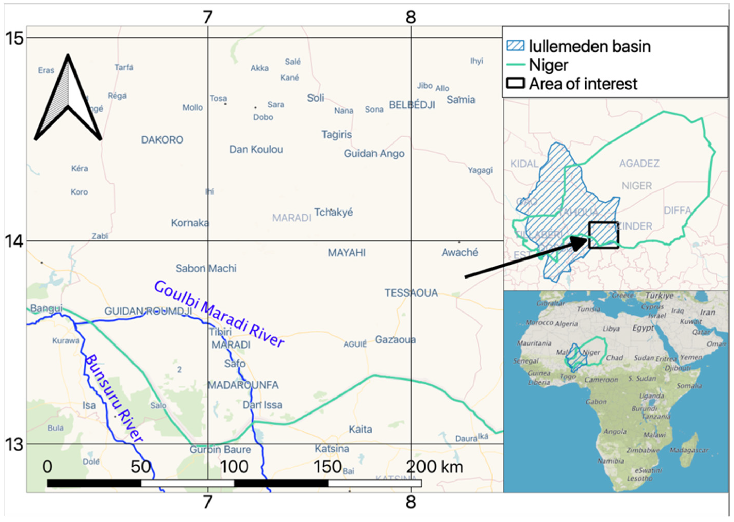
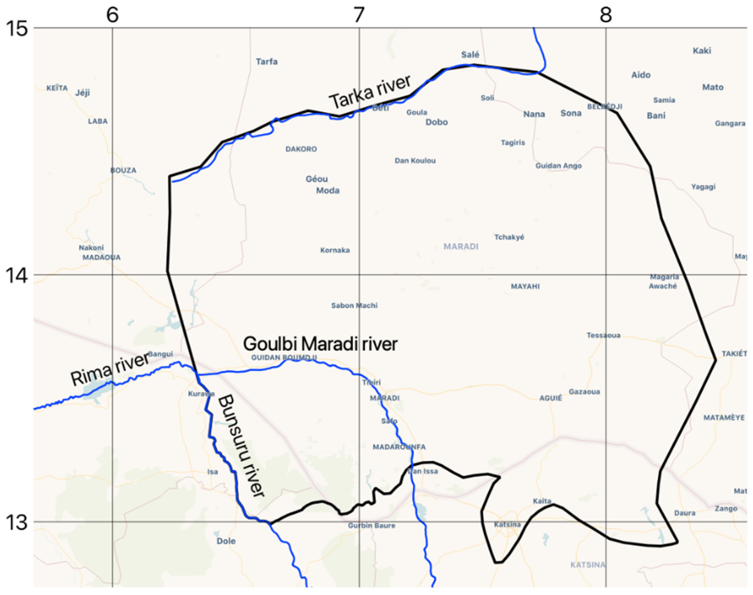
The Goulbi Maradi alluvial aquifer is in the semiarid southern region of Niger, on the southeastern boundary of the Iullemeden Basin (Figure 1). This region is important due to its relatively high population density, ranging from 81 to 105 individuals per square kilometer [1]. The inhabitants rely heavily on rain-fed crops, including sorghum, millet, and cowpeas, as well as animal husbandry for their livelihoods [2,3]. However, these activities have experienced reduced productivity as a result of climate change [2,4], leading to food shortages during dry years [2]. Occasional heavy rains between July and August can result in loss of property, crops, and livestock and occasional deaths [5].
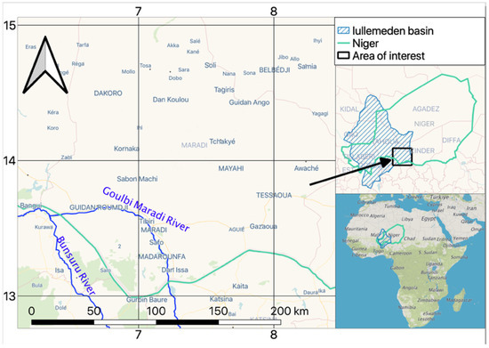
Figure 1.
Map of the Goulbi Maradi Region in South Niger.
The region’s main source of freshwater is from shallow groundwater aquifers located less than 100 m below the surface. These shallow aquifers play a crucial role in supporting the local population during droughts, particularly for agriculture and providing access to water in areas distant from water bodies [6,7,8]. The development of groundwater infrastructure in the region has been limited. Although numerous small-scale wells exist for human and animal use, large-scale groundwater-based irrigation practices are not prevalent. The lack of comprehensive field data on groundwater in the region has posed challenges for effective studies that drive better management practices of these resources [9,10,11].
1.2. Geology and Hydrogeologic Setting
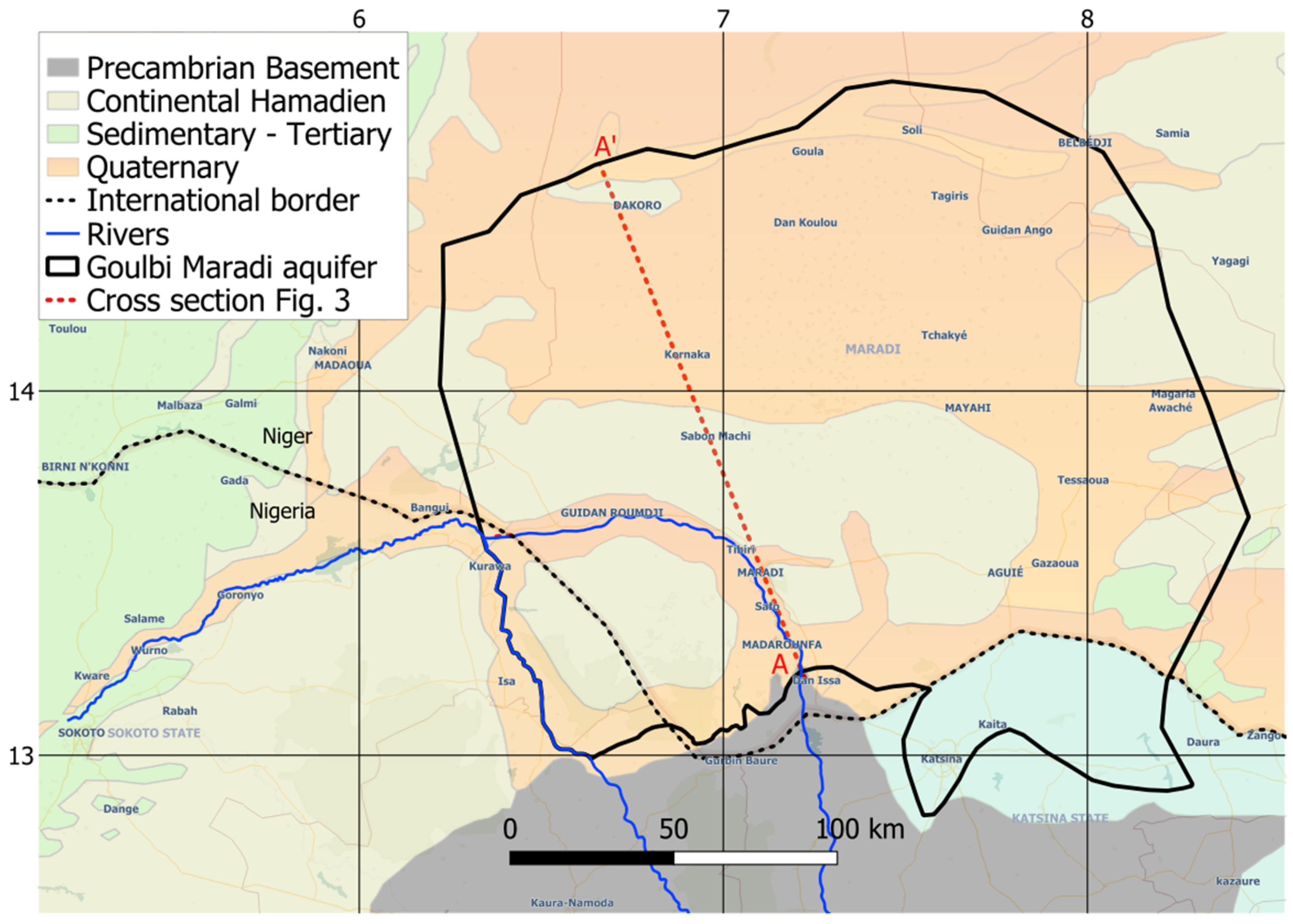
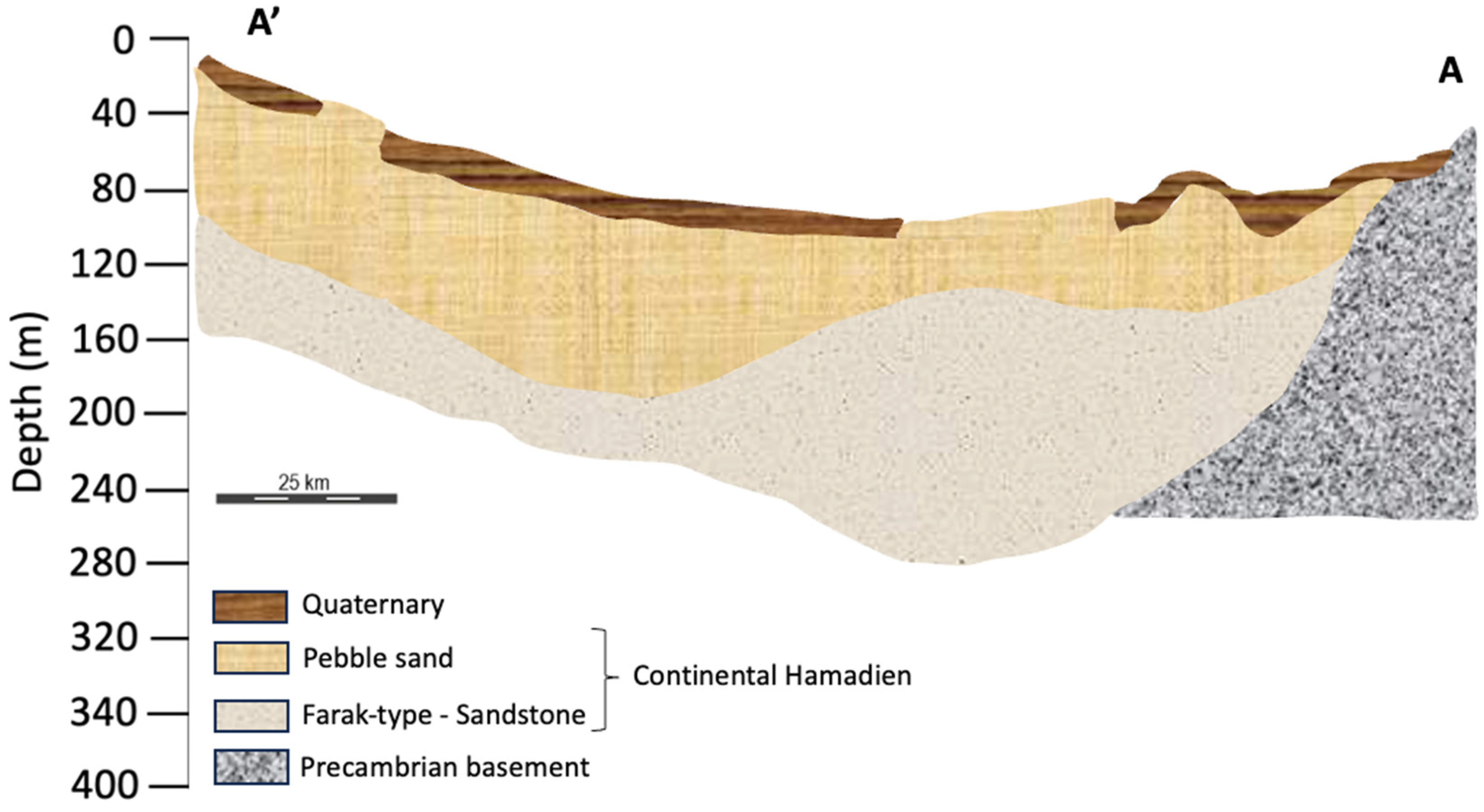
The Goulbi Maradi aquifer is composed of three distinct geologic units: Quaternary formations, the Continental Hamadien of the Upper Cretaceous, and the crystalline to crystallophile Precambrian basement [2]. A surficial geology map is shown in Figure 2 and an idealized cross-section along the A-A’ line of Figure 2 is shown in Figure 3.
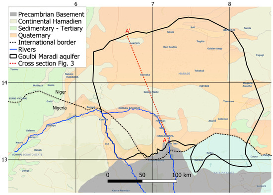
Figure 2.
Geology map of the Goulbi Maradi aquifer.
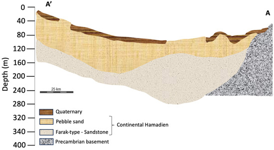
Figure 3.
Idealized hydrogeological cross-section.
The Precambrian basement unit is in the southwest of the aquifer along the Nigerian border and is comprised of granites, gneisses, and schists. The aquifers within this basement area exhibit low well yields, ranging from 0.5 to 3 m3/h, primarily due to limited weathering in the source rock, which results in low permeability. As a result, local communities rely on manual digging of shallow wells in the sediments of ephemeral rivers for their water supply [2].
The Continental Hamadien unit forms an unconfined aquifer located in the central part of the Goulbi Maradi area and extends, as a transboundary aquifer, between Niger and Nigeria [12]. This geological unit consists of two distinct groups: a base composed of Farak-type sandstone with clayey intercalations and an upper part consisting of pebbly sand. Well yields exhibit spatial variation, ranging from 8 to 70 m3/h [2].
Quaternary formations, including aeolian sands, are prevalent on the plateau, while alluvium is present along the Goulbi Maradi river and its tributaries. These alluvial sediments, with a thickness ranging from 10 to 30 m, are the result of erosion from the Continental Hamadien and Precambrian basement [13]. Currently, the alluvial aquifer is primarily used for irrigation purposes, surpassing the usage of the Continental Hamadien aquifer. Pumping rates in the alluvial aquifer are estimated to range from 20 to 70 m3/h, while static water levels vary from 4 to 18 m below the surface [2].
1.3. Previous Research
Researchers have developed numerical groundwater models in the southern Niger region. Qian et al. [7] developed a groundwater model in Zinder, Niger, where groundwater serves as a vital water source for agriculture, industry, and domestic use due to limited surface water and rainfall availability. They developed the model to quantify and assess groundwater resources in the Zinder well field, to generate data to support sustainable local development, and provide a reliable evaluation of the groundwater resources. They found that the simulated heads of their model were in good agreement with field-observed heads and suggested an optimal withdrawal scheme.
The Sahara and Sahel Observatory [14] developed a hydrogeological model for the Iullemeden Aquifer System (IAS) in Niger, Mali, and Nigeria with the goal of improving the assessment of water resources within the aquifer system and identifying hydrogeological risks. They found that withdrawals from the aquifer system have been increasing since the mid-1990s at rates surpassing the available resources. Their simulations suggested that this trend is likely to continue and may have implications beyond the borders of the countries sharing the aquifer, particularly between Niger and Nigeria.
There have been a few additional efforts to characterize the groundwater resources in the region using satellite data due to a scarcity of in situ information. Barbosa et al. [15] analyzed the changes in groundwater storage in two main aquifers in Niger and estimated the groundwater recharge values using the Water Table Fluctuation (WTF) method applied to Gravity Recovery and Climate Experiment (GRACE) satellite data. They concluded that the groundwater storage volume in the two aquifers has increased significantly in the past decade and groundwater infrastructure could potentially be developed further. Scalon et al. [16] used GRACE and MODIS satellite data to track different water storage components, including total water storage, reservoir storage, and vegetation indices. The study emphasized the importance of implementing effective management strategies to address the challenges associated with localized groundwater flooding resulting from the rising groundwater levels in western Africa. Bonsor et al. [17] analyzed the relationships between terrestrial water storage and precipitation in 12 African aquifers using GRACE data combined with estimated changes in groundwater storage using land surface models (CLM2.0, VIC, MOSAIC, and NOAH models) and reported an increase in groundwater from 2012 to 2016, particularly in the Iullemeden Sahelian aquifer.
1.4. Objective
Our objective is to develop a calibrated numerical groundwater model of the Goulbi Maradi aquifer that can be used to analyze the sustainability of various groundwater infrastructure development strategies. We do not present or evaluate any specific strategies, though we do evaluate some general withdrawals. Groundwater model development is especially challenging in this region due to severely limited data for monitoring wells, pumping rates, recharge rates, flow budgets, and other useful data. To mitigate these problems, we developed a model using a novel approach that integrates in situ data and Earth observation data. We use data from the NASA GRACE mission to develop model input and to calibrate the model and estimate water budgets. While other researchers have used GRACE data to augment the construction of groundwater models, this is typically limited to validating groundwater storage changes predicted with the model. Our method involves a more comprehensive strategy where we use both GRACE-derived recharge estimates and storage estimates to bracket the volumetric flow budget in a manner that allows us to estimate pumping rates for the calibrated numerical model.
We use the calibrated model as a predictive tool to analyze several general groundwater withdrawal scenarios to determine the impact on the long-term water budget and sustainability. This is the first model in West Africa to be developed using such a strategy. We estimated how much additional groundwater could be extracted while still maintaining sustainable conditions based on a series of assumptions about groundwater recharge. Performing an in-depth analysis of potential management options is not in the scope of this paper. We evaluate three different scenarios with multiple recharge and pumping assumptions to help identify the boundaries or limits on sustainable groundwater extraction.
2. Data
2.1. Well Data
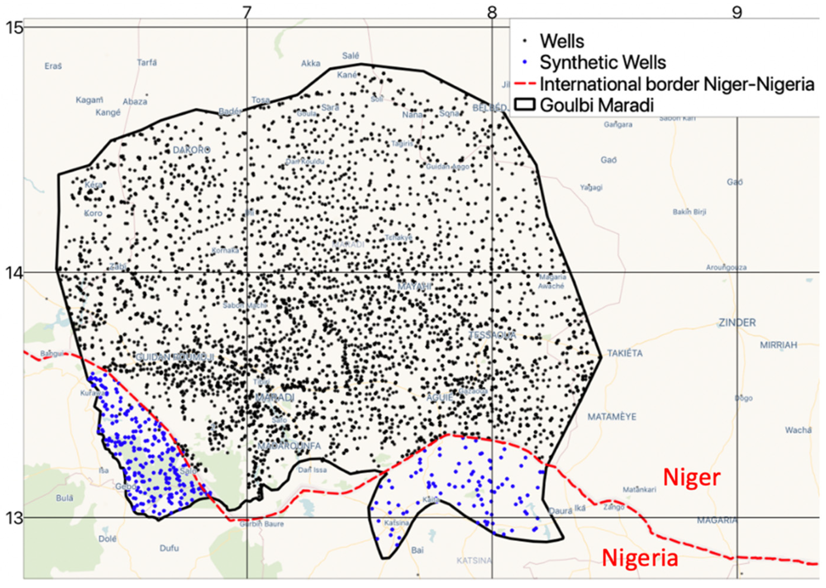
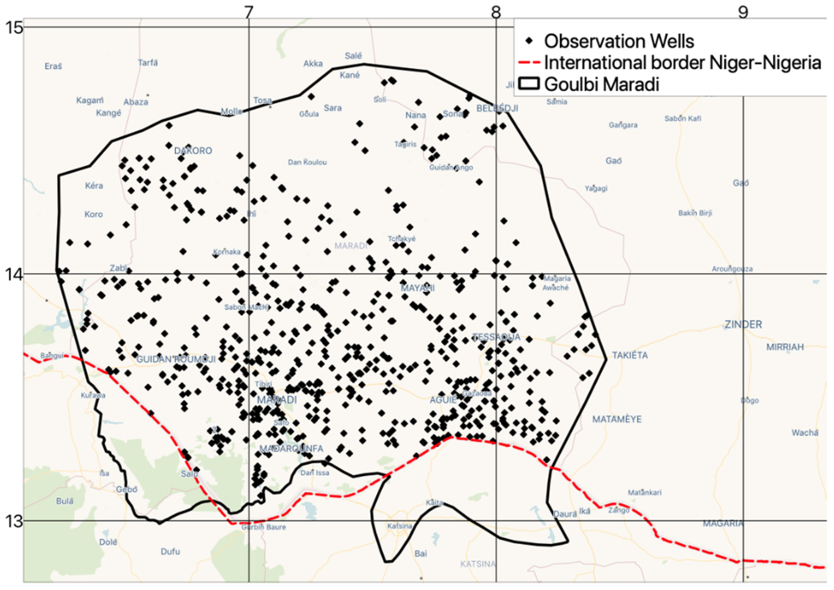
We used data from a well database maintained by the Hydraulic Departmental Direction of Madarounfa, Maradi, Niger (Figure 4). The database includes a variety of attributes, including well locations, well names, well depths, and, in some cases, construction dates. Data on the depth from the surface elevation to the water table and estimated withdrawal rates are included for a subset of the wells; however, it does not contain data on time-varying pumping rates for any wells. Since well data were not available for the portions of the aquifer that extend into Nigeria, we created synthetic wells in these regions at approximately the same density as the wells in Niger. We adjusted the pumping rates of all the wells during calibration, and we adjusted both the density and/or pumping rate of the wells in Nigeria during calibration.
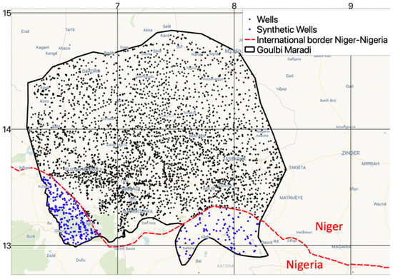
Figure 4.
Well locations in the Goulbi Maradi aquifer.
2.2. Boreholes
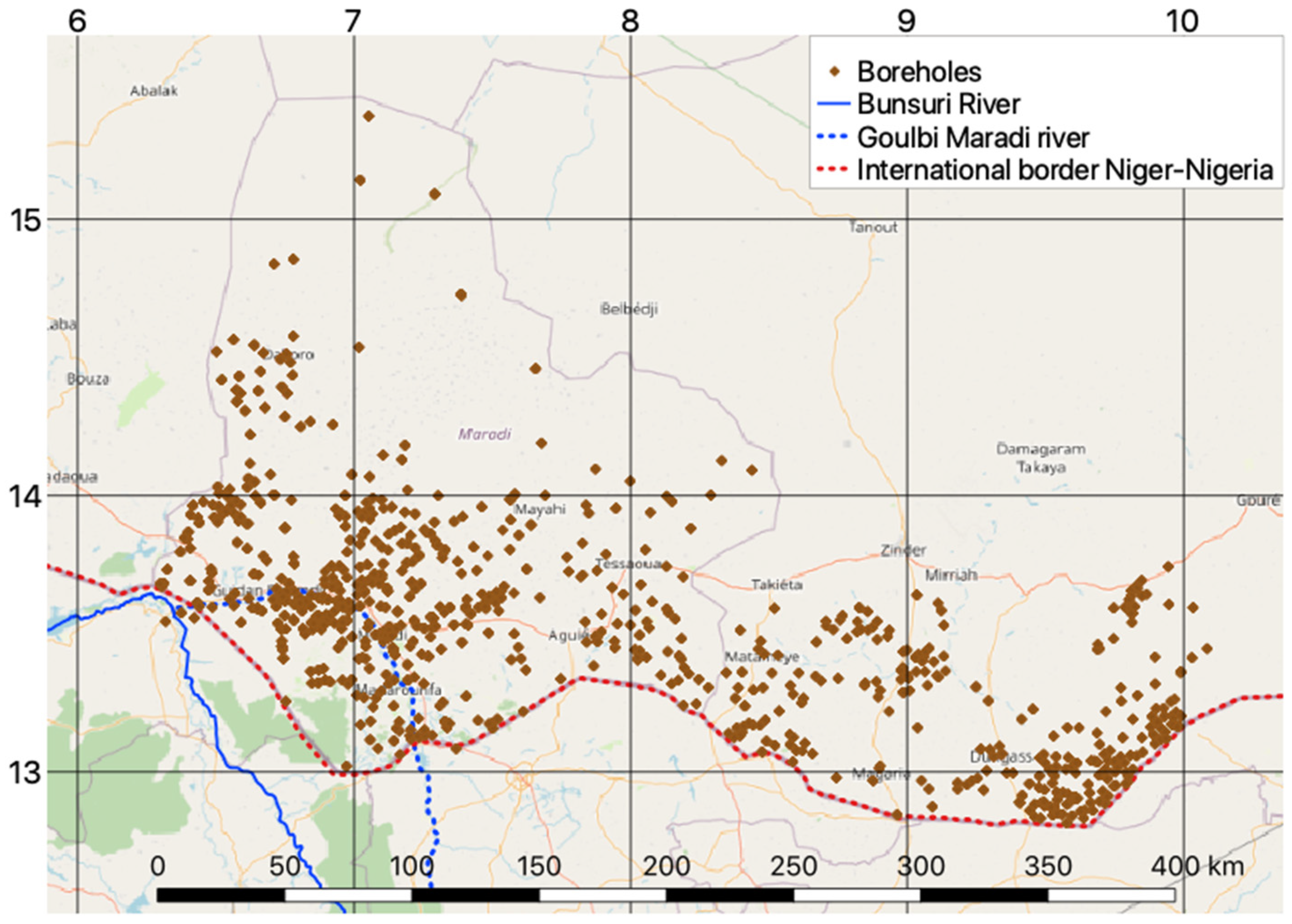
We obtained information on 550 boreholes in the larger Maradi and Korama regions, within the longitudes 6° and 10° (Figure 5). The depths of these boreholes in this region range from 6 to 304 m. Each borehole record includes the borehole ID, latitude–longitude coordinates, and borehole logs with the depths and thicknesses of more than 30 geological materials.
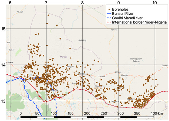
Figure 5.
Boreholes located in Goulbi Maradi and Korama region.
2.3. GRACE Data
The GRACE mission was launched in 2002 and consists of two satellites positioned 220 km apart that travel along the same orbital path. The initial GRACE mission spanned 15 years, from 2002 to 2017 [18], while the subsequent GRACE Follow On (GRACE FO) mission, launched in May 2018, continues to provide monthly gravitational anomaly data to the present [19,20].
The distance between these satellites varies in response to fluctuations in the Earth’s gravitational field [21,22,23]. Precise measurements of these distance changes are used to quantify gravitational anomalies, indicating variations in mass [22]. These variations are mainly driven by fluctuations in water storage for most locations, as there are limited other factors that significantly affect the Earth’s mass on such a large scale.
GRACE data are processed by NASA to generate the Total Water Storage Anomaly (TWSa) dataset, which captures the change in water storage globally in an anomaly format [24]. GRACE data have been used for various applications, such as flood studies [25,26,27,28,29], drought studies [30,31,32,33,34,35], and general hydrologic investigations focusing on regional water storage and trends [36,37,38]. Recent research has demonstrated the use of GRACE data for monitoring variations in groundwater storage [39,40,41,42,43] including variations in groundwater depletion in arid and semiarid regions [15,44,45]. GRACE data have proven valuable in monitoring global water storage changes [46].
3. Methods
3.1. Conceptual Model
We developed a conceptual model of the Goulbi Maradi aquifer system, including boundary conditions, hydrostratigraphy, and a flow budget before constructing the numerical model. This section presents that conceptual model.
3.1.1. Boundary Conditions
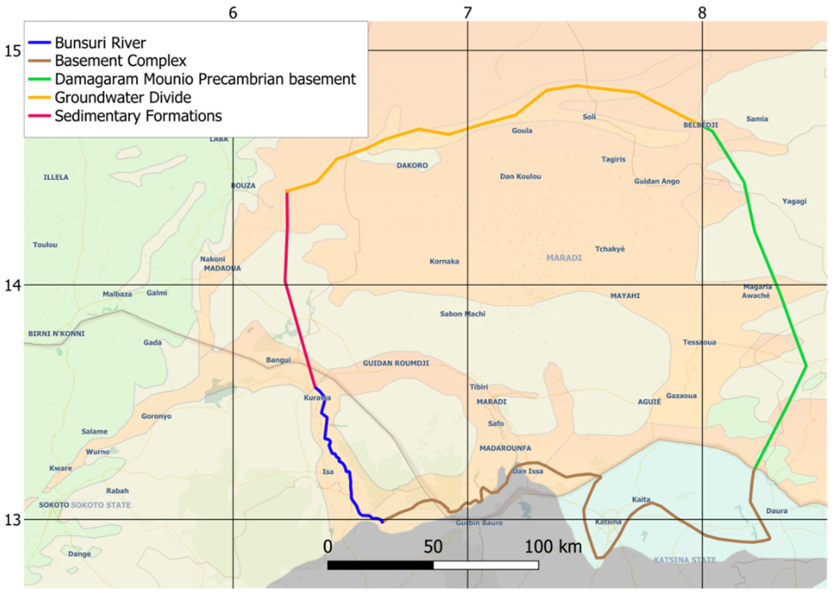
We delineated the boundary conditions based on a combination of geological and hydraulic features (Figure 6). The boundaries were based on (1) groundwater divide located to the north, (2) the Damagaram Mounio Precambrian basement to the east, representing a no-flow boundary, (3) the Bunsuru river and the sedimentary formations of the Iullemeden Basin to the west, establishing both a river and a no-flow boundary, and (4) the basement complex to the south, establishing a no-flow boundary.
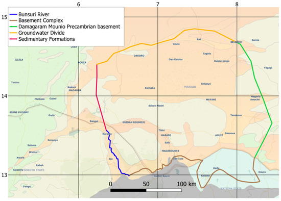
Figure 6.
Boundary conditions for our model of the Goulbi Maradi aquifer.
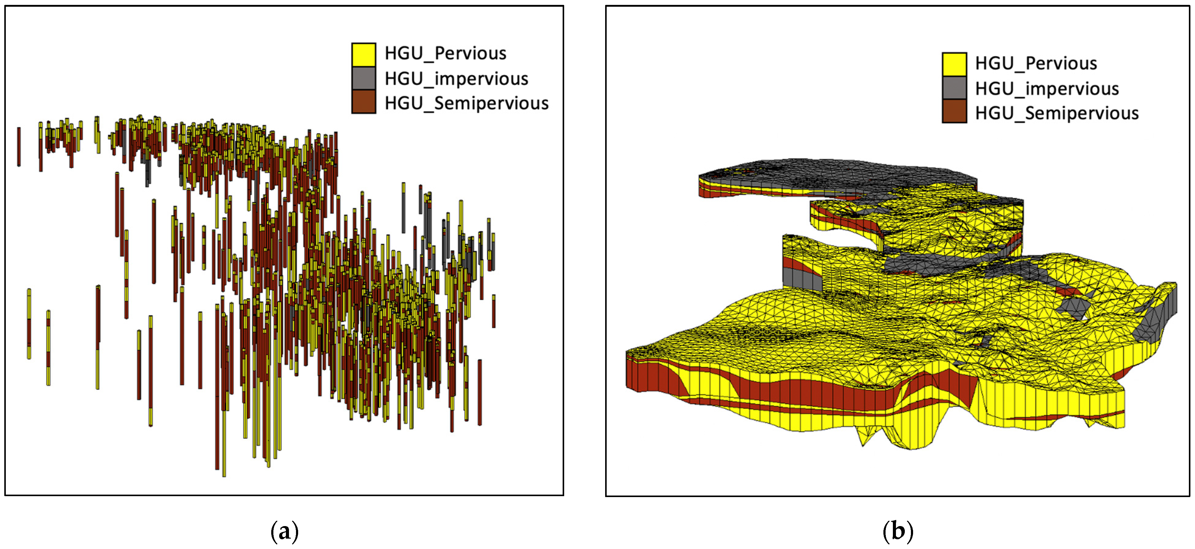
We used the borehole data and applied a “horizons to solids” geometric algorithm described by Lemon and Jones [47] to build three-dimensional solid models of the hydrostratigraphy in the region. This algorithm assigns horizon IDs to each borehole contact, with the IDs representing the sequence of sedimentary layers. The algorithm generates solids by interpolating the surfaces defined using the horizons and extruding them into 3D volumetric structures (Figure 7). We classified the 30 materials into three main hydrogeologic units (HGUs) corresponding to pervious, impervious, and semipervious units.
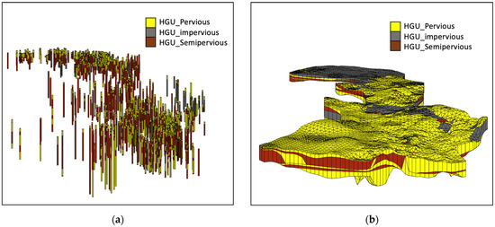
Figure 7.
(a) Three-dimensional representation of borehole logs. (b) Solids generated with the horizons-to-solids algorithm.
3.1.2. Flow Budget
Developing a water budget involves quantifying the major sources and sinks in the aquifer. We classified them into gains and losses from rivers, losses to evapotranspiration, recharge to the aquifer from precipitation and infiltration, extraction with pumping wells, and fluctuations in aquifer storage. Due to data scarcity in the region, quantifying the water budget proved to be one of the most challenging aspects of this project and required the development of an integrated method that incorporates Earth observations.
In general, the water budget can be defined as follows:
i.e., the change in volume of water stored in the aquifer is the difference between aquifer inflows and outflows. More specifically,
where:
storage = Change in aquifer storage
Recharge = Infiltration from rainfall
Riverin = Gains from rivers
Riverout = Losses to rivers
ET = Evapotranspiration
Qwells = Extraction from wells
Changes in aquifer storage (Δstorage). Change in aquifer storage is often the most difficult part of the water budget to quantify. Storage change estimates can be made by analyzing water table fluctuations over time and estimating the aquifer storage coefficient. However, there are very few water level measurements in the Goulbi Maradi region and certainly not enough to characterize storage change over time. To quantify the storage, we used GRACE to derive estimated changes in groundwater storage [39,41,48,49]. To separate the groundwater component from the overall water storage, which includes surface water changes, we subtracted surface water components generated with a land surface model from the GRACE Total Water Storage Anomaly (TWSa) [15,39,43,48,49,50,51,52,53,54,55,56,57,58,59]. For this study, we used data from NASA’s Global Land Data Assimilation System (GLDAS) model for snow water equivalent (SWE), plant canopy (CAN), and soil moisture (SM). We used the GRACE Groundwater Subsetting Tool (GGST) to compute groundwater storage changes [39]. GGST converts the GLDAS data to an anomaly format to obtain SWEa, CANa, and SMa, and then computes the groundwater storage anomaly using Equation (3) [15].
GWSa = TWSa − (SWEa + CANa + SMa)
This resulted in a monthly GWSa dataset in units of centimeters of liquid water equivalent (LWE) in gridded format with a resolution of 1 × 1 degree over the period from 2002–2022. We computed the storage volume by multiplying the change in GWSa LWE by the area of the aquifer.
Infiltration (Recharge). The primary source of water to the aquifer is recharge resulting from precipitation. Recharge is notoriously difficult to estimate. It can be estimated with field tests [60], but the tests are expensive, time-consuming, and do not yield results with a high degree of accuracy. Over a long period of time, aquifer recharge estimates can be iteratively refined. However, these long-term data are scarce in Niger.
Remote sensing techniques can be used to assess the spatial and temporal distribution of recharge [61]. Barbosa et al. [15] and Wu et al. [60] have used remote sensing data to estimate groundwater recharge values in two important aquifers in Niger and the Ordos Basin in China, respectively, using the WTF method [62,63].
We estimated groundwater recharge values using the WTF method, which analyzes the seasonal changes in piezometric head or aquifer storage [62,63]. Using WTF, the rising portion of the annual fluctuation is categorized as recharge. We calculated recharge (R) in cm/year using the WTF method as defined with Equation (4):
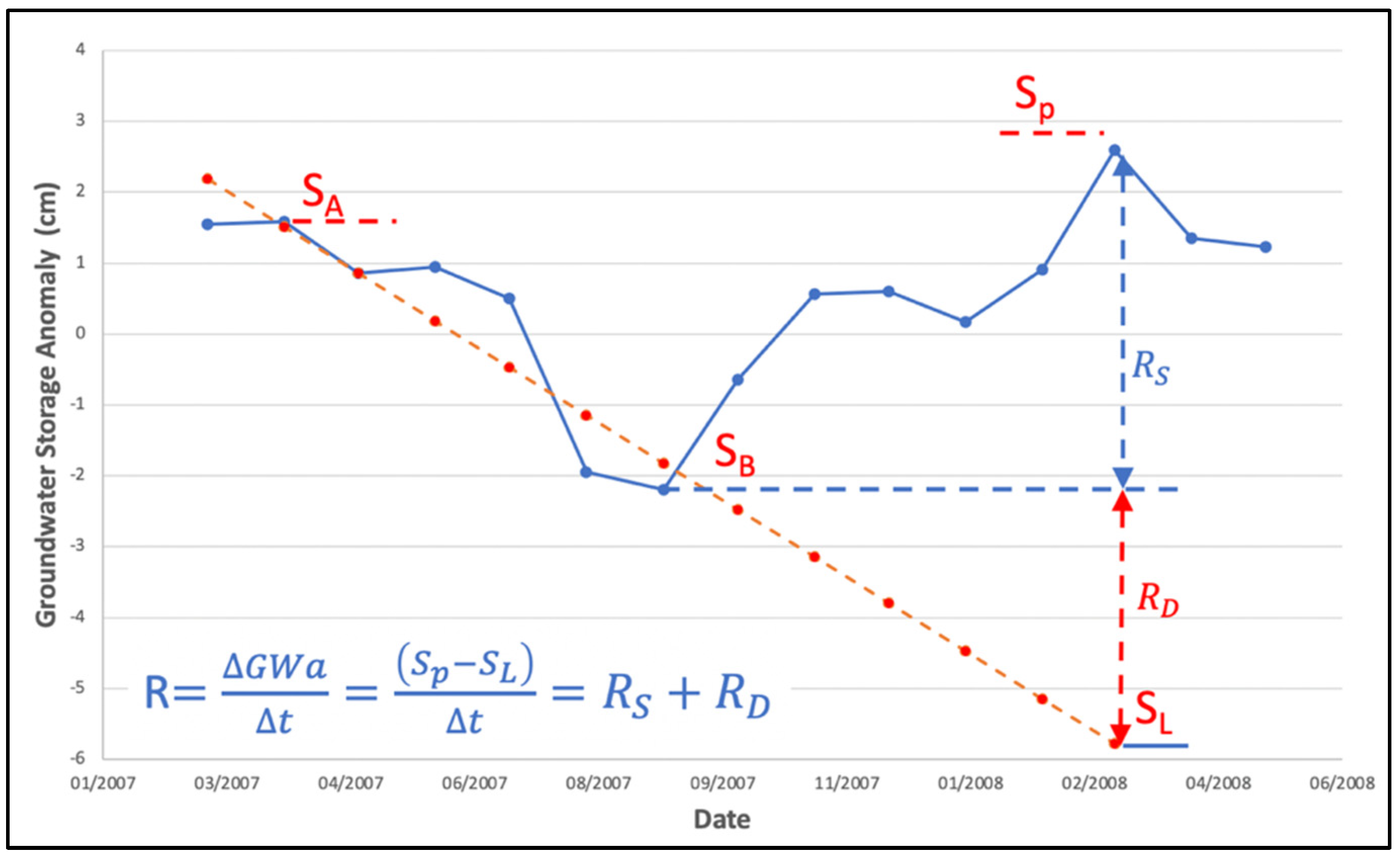
where ∆h represents the change in height of the water table (cm), t is the specified interval over which the change was measured, and Sy denotes the specific yield [62]. For this study, instead of relying on well measurements, we used the GRACE-derived GWSa in place of Sy∆h. We applied this approach to each 1-year period as shown in Figure 8.
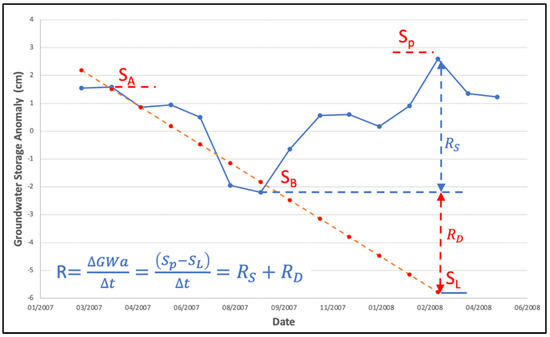
Figure 8.
Conceptual diagram of the two approaches of the WTF method.
Using the WTF approach, there are two approximations commonly used to estimate the groundwater recharge from the seasonal fluctuations. The first method involves determining the net recharge as the distance between the trough of decline and the peak of the rise [15]. In the second method, the downward trend from the peak of the previous year to the trough is projected using a depletion curve. This projection allows us to find the recharge that balances the continuing discharge. The total recharge is then calculated as the sum of and [15].
Gains and losses from rivers (Riverin, Riverout). In the Goulbi Maradi aquifer, there are two primary rivers: the Bunsuru river, part of the upper Rima basin, and the Goulbi Maradi river, which spans both Niger and Nigeria (Figure 9). The Tarka river, located on the north boundary, is an intermittent stream. The Goulbi Maradi river serves as the primary source of surface water in the transboundary river basin. Its flow is seasonal, occurring irregularly between July and October, influenced by local rainfall and water release from the Jibya dam in northern Nigeria. The river travels 120 km into Niger, where it joins Sokoto Rima, a tributary of the Niger River [64,65]. These rivers can act as sources or sinks depending on the elevation of the groundwater relative to river stage with the flow rate between the river and surface water mediated by the thickness and permeability of the river bottom sediments.
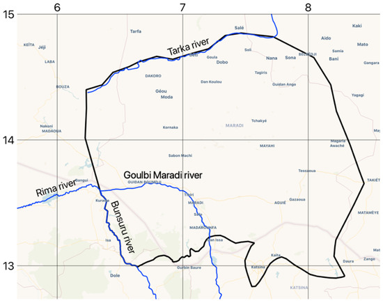
Figure 9.
Rivers located in the study area.
Evapotranspiration (ET). For areas in the region where the groundwater is near the surface, groundwater is lost via evaporation and transpiration. We assumed values similar to those reported by Lutz et al. [66] where they assumed that ET occurs when the water table is located in the upper 3.5 m of the soil profile and the rate varies from zero at the extinction depth (i.e., 3.5 m) to a maximum of 540 mm per year (0.0015 m/day) at the surface.
Well extraction (Qwells). The well database provided information on the rate at which new wells were added over the period 2002 to 2009 but did not contain any reliable data about pumping rates. Because we were able to estimate both recharge and the change in groundwater storage, the extracted water volume is the only major unknown in Equation (3). We estimated the overall pumping rate by adjusting the pumping rates until the model-simulated storage matched the GRACE-derived groundwater storage changes. This process is described in more detail below in the calibration section. This innovation is the main contribution of this study that allows calibrated model development in regions without groundwater extraction data.
3.2. MODFLOW
We developed a numerical groundwater model based on the presented conceptual model using the 2005 version of MODFLOW [67]. We used version 10.5 of the Groundwater Modeling System (GMS) software to process the borehole, GIS, and other geospatial data to construct the MODFLOW input files, run the simulations, and calibrate the model [68].
4. Model Development
4.1. Groundwater Volume
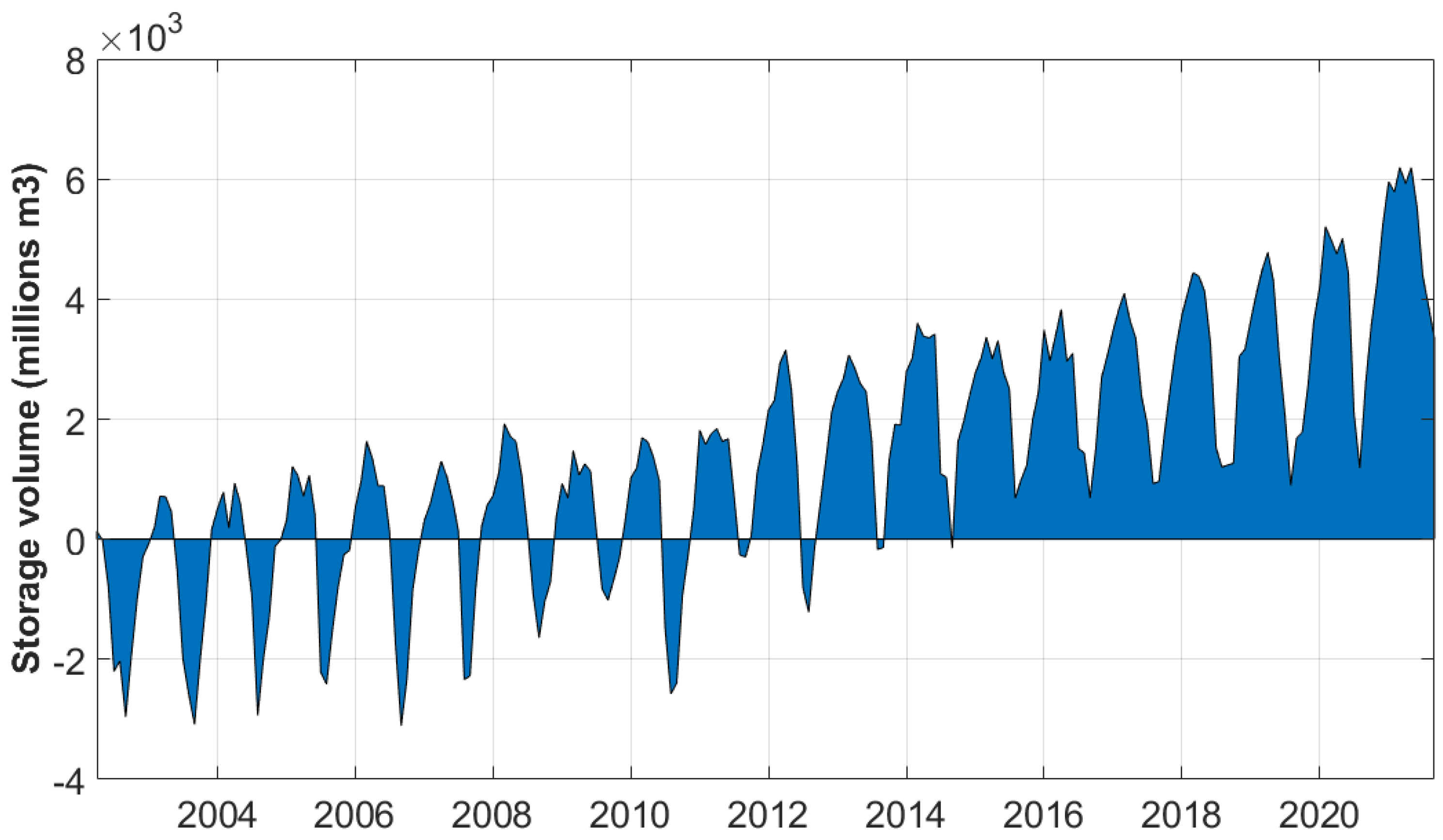
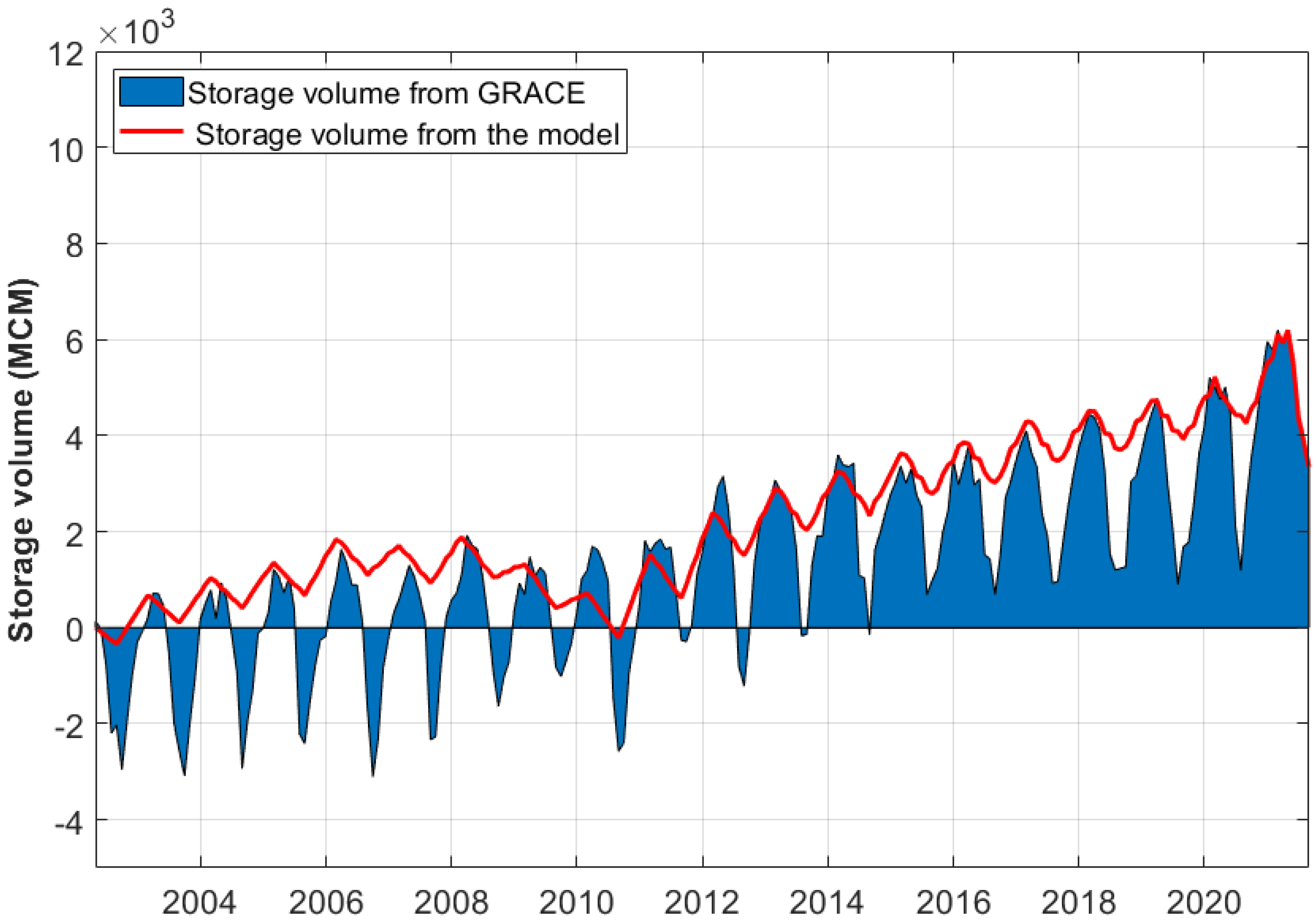
We multiplied the GWSa liquid water equivalent by the area of the aquifer to obtain estimates of groundwater storage volume change from 2002 to 2022 (Figure 10) on a 1.0-degree resolution grid. Since the Goulbi Maradi aquifer only covers a range of 1.5 degrees latitude, the groundwater storage anomaly is more representative of the larger Iullemeden Basin of which the Goulbi Maradi aquifer is just a portion. This adds an element of uncertainty to the storage values that must be considered during the calibration process.
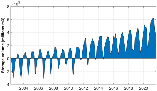
Figure 10.
Storage volume in millions of cubic meters in the Goulbi Maradi aquifer.
4.2. Recharge Rates
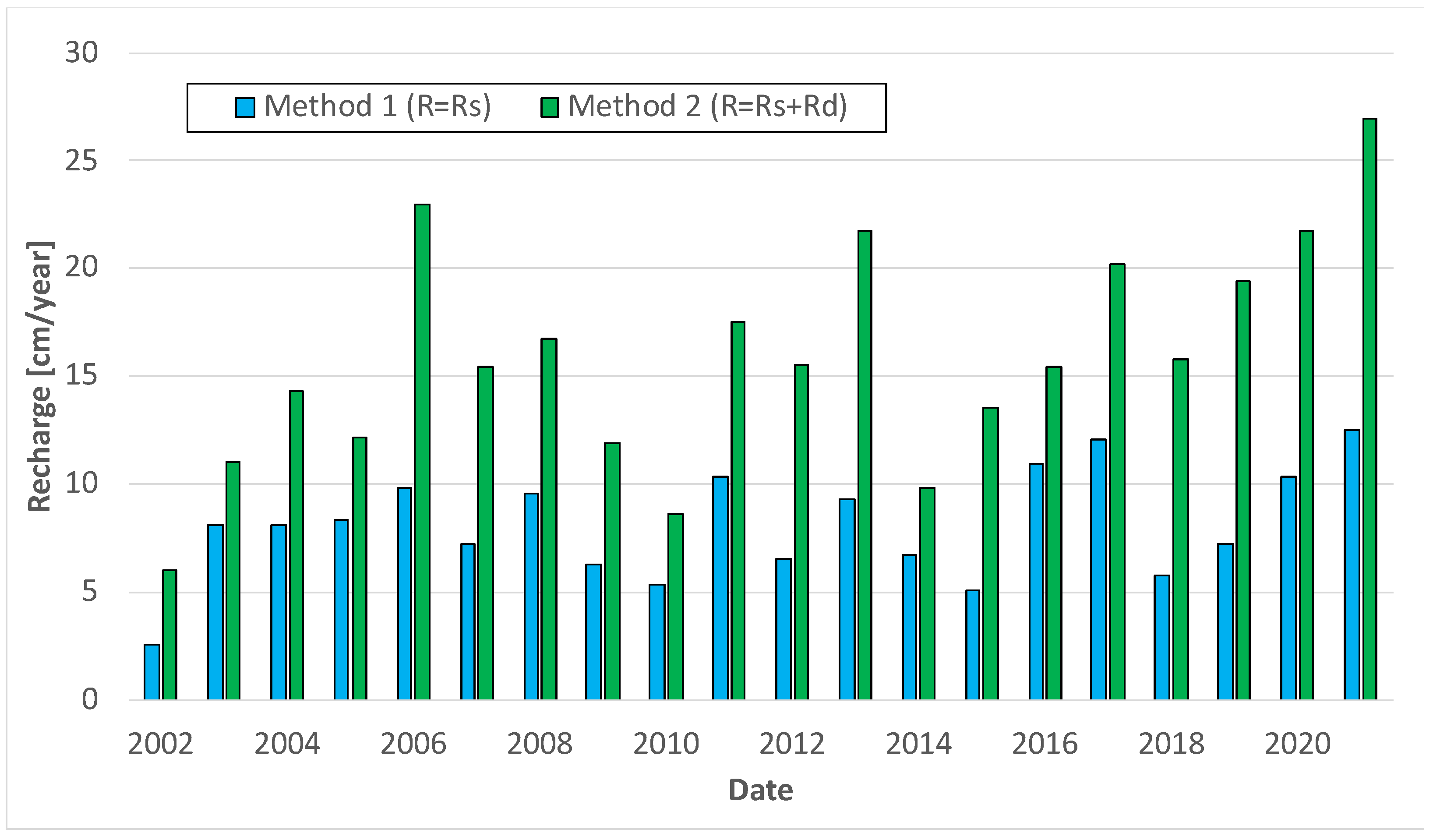
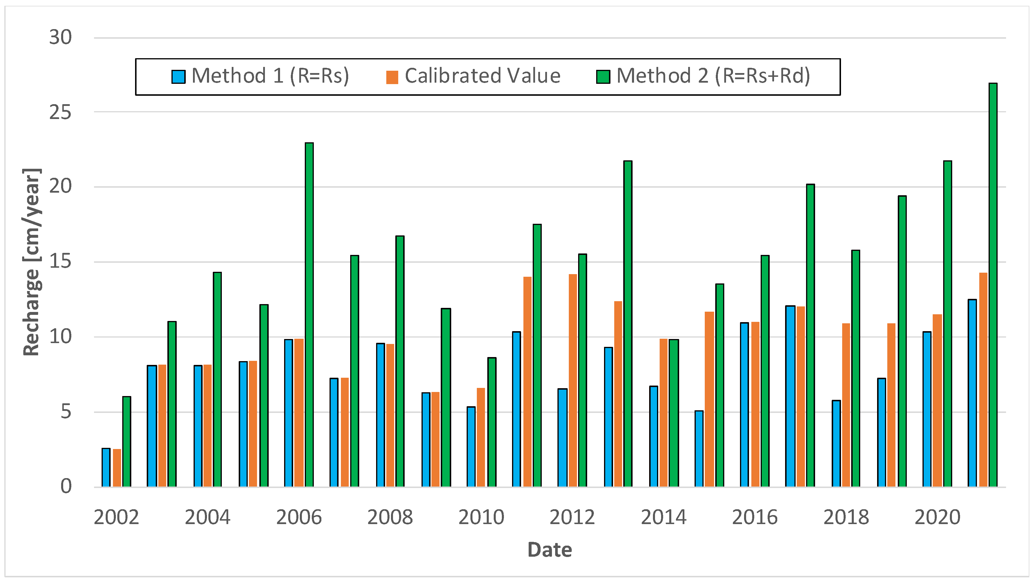
Using the WTF method described above, we examined the GWSa seasonal fluctuations and estimated both a low (Method 1, R = RS) and a high (Method 2, R = RS + RD) recharge value (Figure 11). We compared our estimates with those from other studies conducted in the same region. We found that recharge rates determined through chemical methods were lower than our assessments. For values derived by other researchers via the WTF method, our estimations using WTF Method 1 align with the reported range, while our calculations using WTF Method 2 yielded values higher than reported values [15]. Thus, the two methods provide a realistic lower and upper bound of expected actual recharge values.
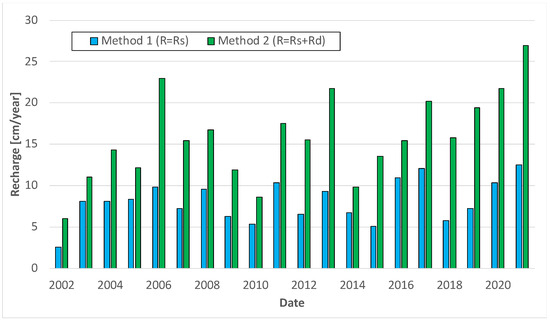
Figure 11.
Annual recharge values estimated with the WTF method for the Iullemeden Basin.
4.3. Computational Grid
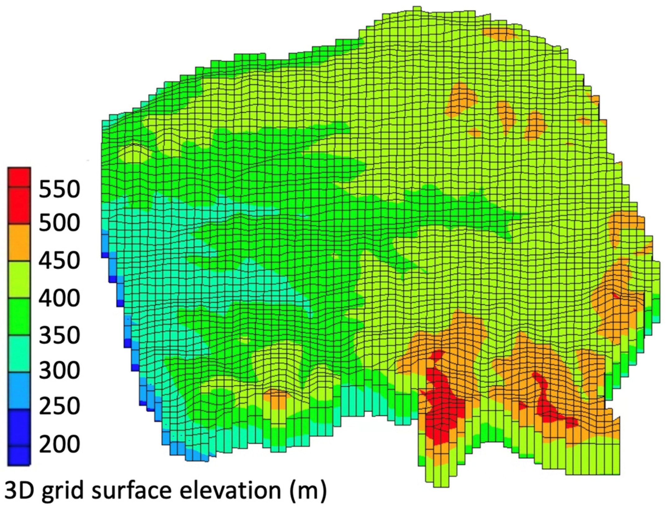
We identified two stratigraphically distinct layers by analyzing the borehole data (Figure 7). We used borehole logs and a DEM of the ground surface to generate a MODFLOW computational grid with 80 cells in the X and Y directions and two layers in the Z direction using the described boundary conditions (Figure 12).
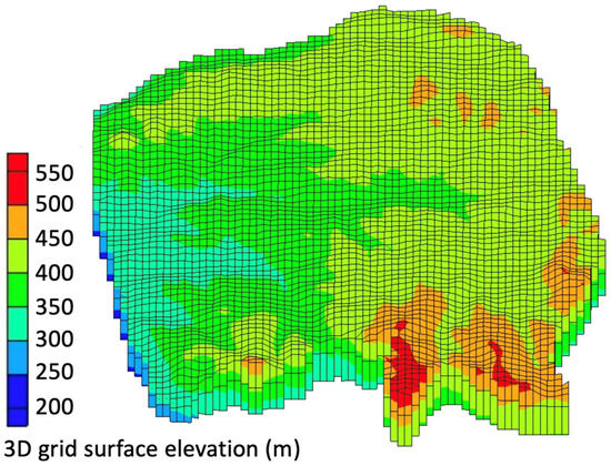
Figure 12.
Three-dimensional grid representation of the Goulbi Maradi aquifer.
4.4. Model Calibration
To calibrate the model, we used recharge, hydraulic conductivity, and pumping rates as adjustable parameters, and head observations and storage changes as the observations to match. We initially developed a steady-state groundwater model to gain insights into key aquifer characteristics, including conductivity values, evapotranspiration rates, approximate pumping rates, recharge values, and head distribution across different zones of the aquifer. We then converted the steady-state model into a transient model encompassing 40 stress periods, with each stress period comprised of six timesteps, representing monthly time steps from 2002 to 2021. We performed both manual (trial and error) calibration and automated calibration using the PEST utility [69].
4.4.1. Parameters
We assumed recharge was zero during the dry half of the year and at the full rate during the wet period using a range of WTF-derived values (Figure 11). We identified a set of polygonal zones that allowed us to bias the estimated recharge toward either the high or low estimate based on the feedback from the calibration process. We varied hydraulic conductivity using polygonal zones delineated from the 3D hydostratigraphic regions based on feedback from the calibration process. We assigned pumping rates to wells organized by zones based on feedback from the calibration process. In addition to the pumping well locations, we had data indicating how many new wells were added each year between 2002 and 2009, thereby resulting in a gradual increase in overall groundwater extraction during this period. Given the limited number of new wells constructed between 2009 and 2019, we maintained constant pumping rates during this period.
4.4.2. Observations
One limitation of this study is the lack of time-varying groundwater levels at monitoring wells, which are typically the primary observation used for model calibration. We obtained 723 observed heads, each of which was from a separate well at a unique point in time between 2002 and 2009 (Figure 13). These were depth-to-water table values collected during well construction. Since we did not have ground surface elevations for the wells, we sampled a global, 30 m digital elevation model [70] to estimate ground surface elevations at the well locations and then calculated water table elevations by subtracting the depth-to-groundwater values from the estimated surface elevations.
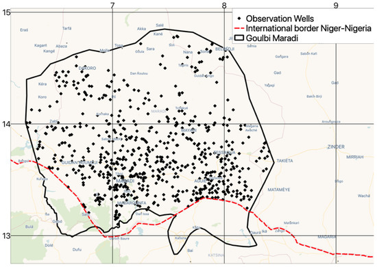
Figure 13.
Observation wells in the Goulbi Maradi aquifer.
We used the GRACE-derived storage changes as an additional calibrated target. One of the outputs of the model was the change in aquifer storage. We compared these model-simulated storage changes with the GRACE-derived storage changes and adjusted our model inputs until the two estimates matched reasonably well. The storage change results were most sensitive to the groundwater pumping rates and to the recharge values. We found that these storage observations were particularly useful during the period of 2009 to 2021 where we did not have field-observed heads.
4.5. Conversion to Predictive Model
We used the calibrated model as a predictive model forecasting aquifer conditions 40 years into the future to evaluate aquifer behavior. This included aquifer response to some general groundwater development strategies to determine what level of groundwater development could be implemented that would result in sustainable aquifer conditions.
5. Results
5.1. Calibration Results
Through model calibration, we determined a set of parameter values that minimized the difference between the simulated and observed head and storage values.
5.1.1. Optimized Parameter Values
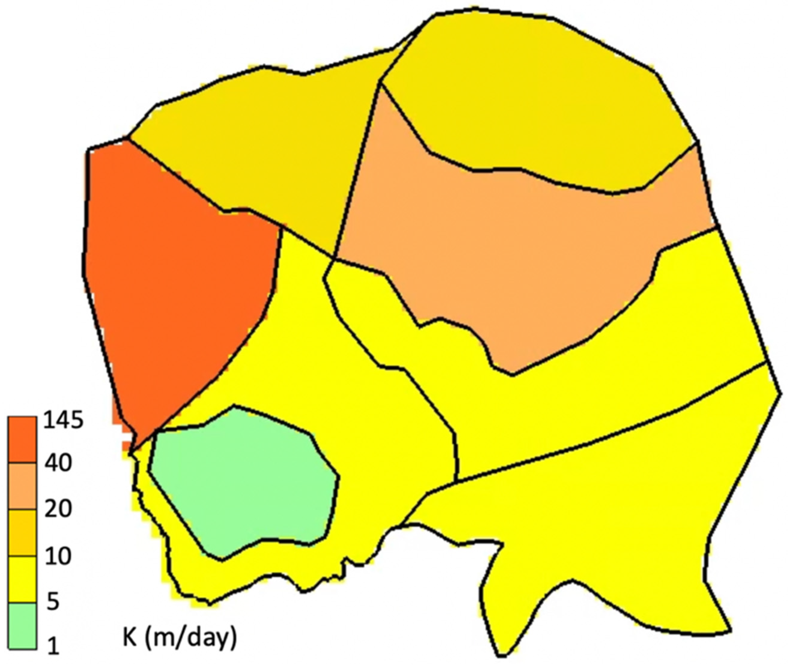
The hydraulic conductivity values for our model of the Goulbi Maradi aquifer that resulted in the best calibration are presented in Figure 14. The majority of the zones have conductivity values below 40 m/day, indicating the presence of semi-pervious very fine sand materials [71]. The exception is the polygon located on the western side above the Goulbi Maradi river, which has a conductivity value of 145 m/day. This area is composed of pervious materials, primarily sand and gravel.
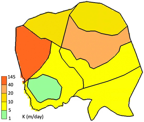
Figure 14.
Estimated hydraulic conductivity (m/day).
The estimated recharge values based on the best fit to the data are shown in Figure 15. In the initial 8 years of the study, the best-fit recharge values were those obtained using Method 1. Specifically, we found the lowest values within the range between the recharge values estimated with Method 1 and Method 2 to provide the optimal fit. However, beginning from 2009, the calibrated recharge values fell within the upper part of the range through 2015 followed by the lowest values in the years 2016 and 2017, and then trended again toward lower values through the remaining years.
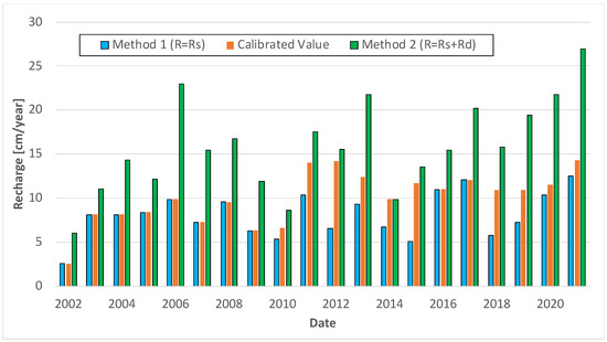
Figure 15.
Optimized recharge values.
We adjusted the pumping rates in the model using nine distinct zones. The estimated pumping rates varied between 550 and 1520 m3/day.
5.1.2. Computed vs. Observed Head Values
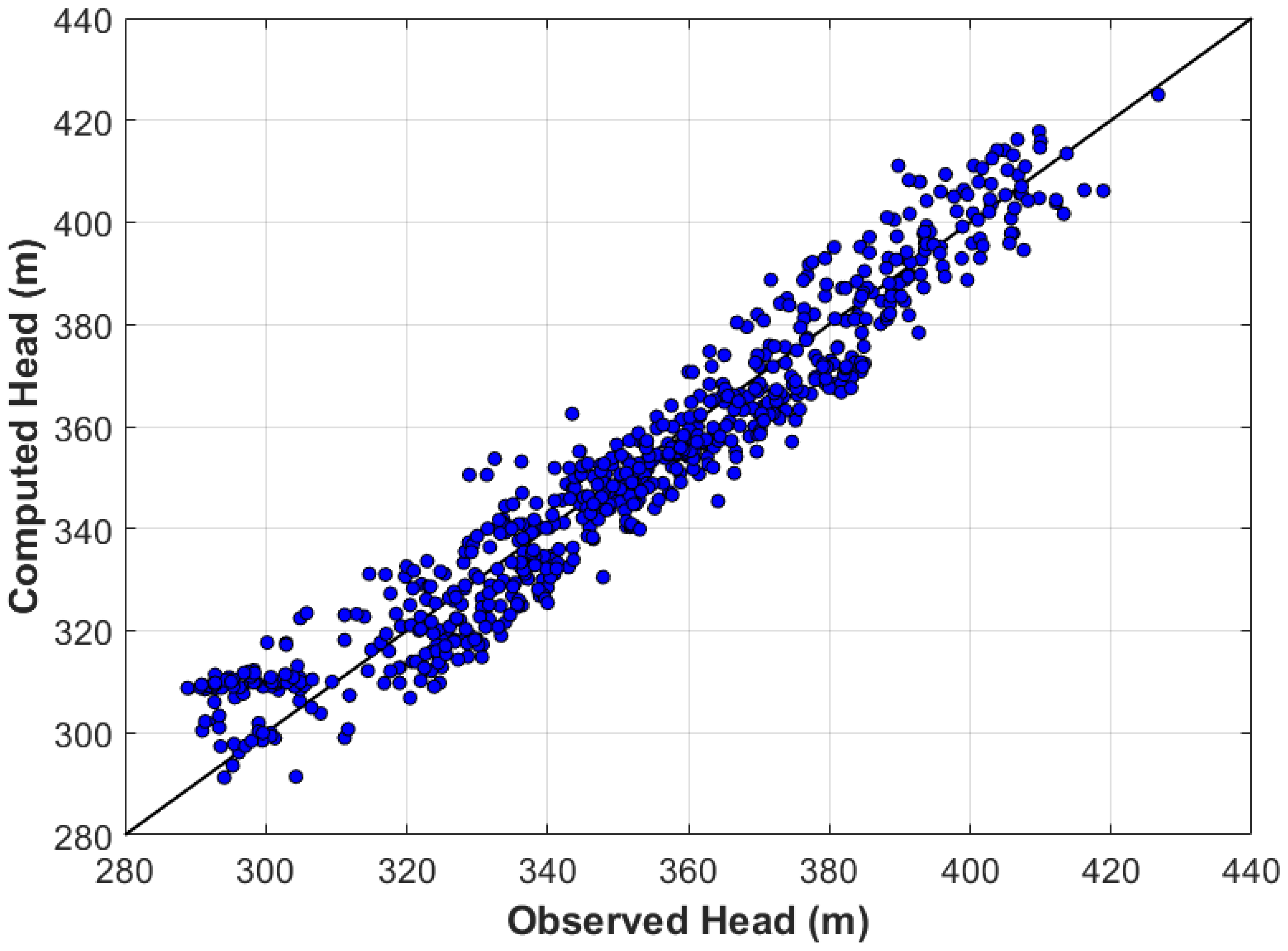
We applied three commonly-used statistical metrics to evaluate the fit between the model-simulated heads and the 723 observed heads: root mean square error (RMSE), mean error (ME), and mean absolute error (MAE) [72,73]. The resulting metrics were RMSE: 8.43 m, ME: 0.42 m, and MAE: 6.89 m. The ME values indicate that the positive and negative errors are mostly balanced with a small positive bias. The RMSE and MAE values are relatively close, indicating that there are few outliers in the dataset. Figure 16 illustrates a comparison between the observed and simulated heads with the solid line indicating an exact match. Together, the computed vs. observed plot and the error metrics indicate a reasonably good fit for a regional model.
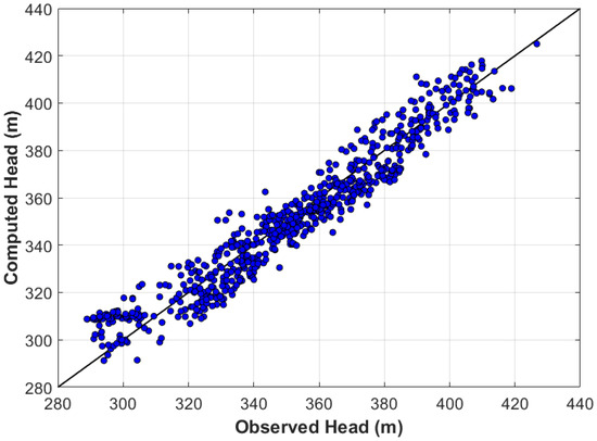
Figure 16.
Simulated vs. observed head values in the Goulbi Maradi aquifer.
5.1.3. Storage Changes
Figure 17 presents a comparison of the cumulative groundwater storage volume estimated using GRACE data and that simulated with the model for the period 2002 to 2021. The simulated storage changes show the same seasonality as the GRACE-measured changes but are biased to the high side. During calibration, we found that we could not reduce the storage changes further while still matching the head observations and maintaining model stability. Because of the resolution of the GRACE grid cells, the GRACE results include data from the larger Iullemeden Basin, which contains the smaller Goulbi Maradi aquifer. The Goulbi Maradi aquifer sits on the southern edge of the Iullemeden Basin. The GRACE cells overlapping the Iullemeden Basin include more arid zones north of the Goulbi Maradi aquifer; therefore, it is reasonable to expect that the storage changes would be higher in the Goulbi Maradi aquifer given that it is in a less arid portion of the Iullemeden Basin.
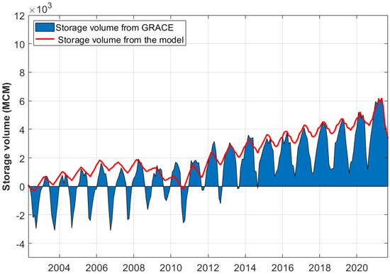
Figure 17.
Simulated vs. observed groundwater storage changes in the Goulbi Maradi aquifer.
5.2. Predictive Model
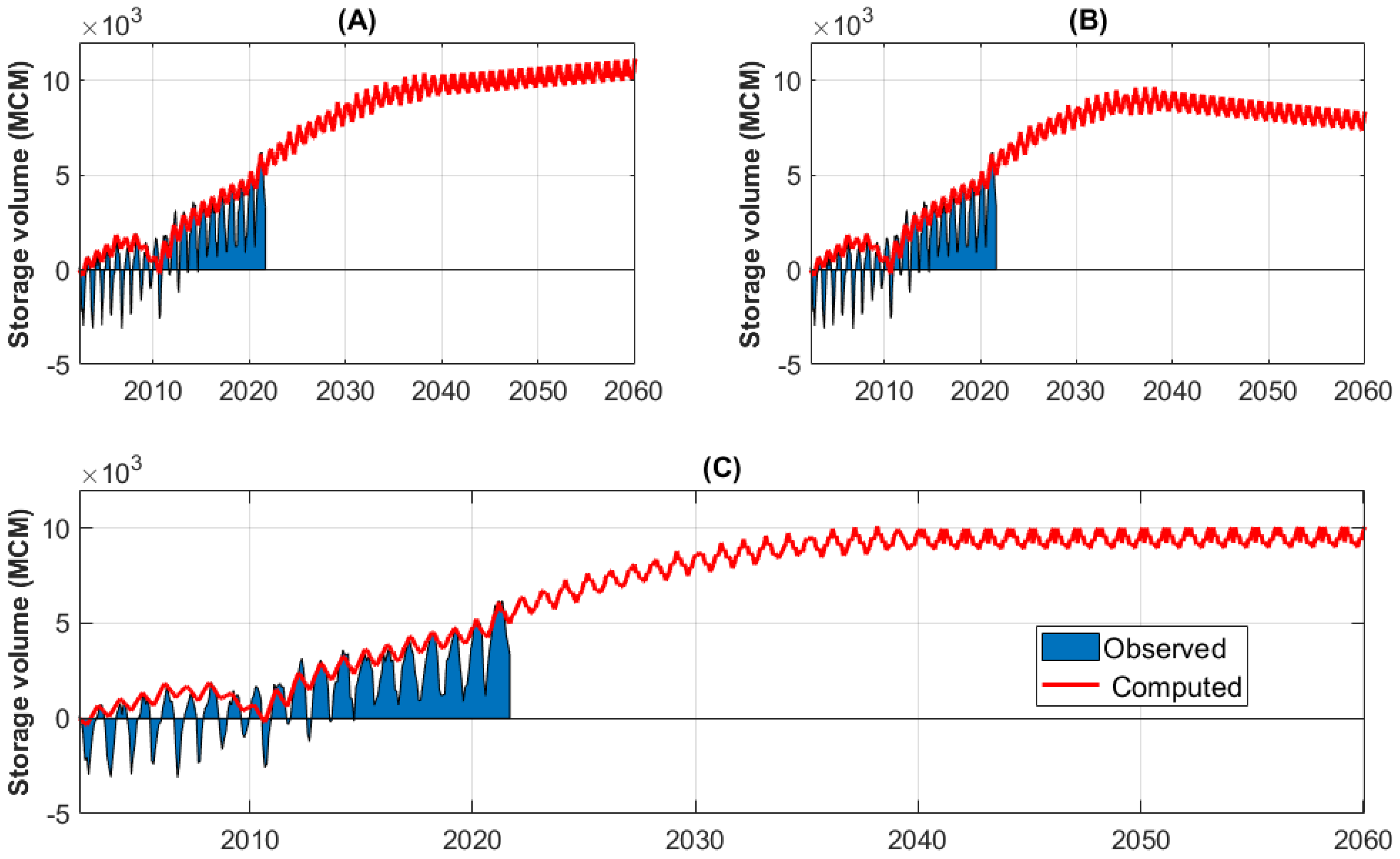
Following successful calibration, we used the model to predict changes over an additional 40 years, to February, 2061. We simulated a general set of groundwater development scenarios involving an increase in pumping commensurate with the development of additional groundwater infrastructure in the region. For each of these scenarios, we assumed the average recharge rate either stayed the same or increased by some percentage in the future and evaluated percentage increases in pumping over the current rates. The objective of this exercise was to determine what percentage increase in pumping would result in sustainable aquifer conditions for each of the recharge assumptions.
5.2.1. Scenario 1: 5-Year Average Recharge
For the first set of scenarios, we assumed future recharge values were the same as the last 5 years of the calibration period (2016–2021). Given that this 5-year period corresponds to an increase in storage and is therefore relatively wet, this is an optimistic assumption. Using this recharge rate, we ran the model iteratively to determine a pumping rate that resulted in a stable water balance.
Figure 18 shows the results of this scenario. In panels A and B, we increased the pumping rate by 20% and 30%, respectively, over the first 20 years, and then held it constant for the final 20 years. In the 20%-increase scenario (panel A), storage increases indefinitely, indicating that the aquifer can sustain a higher pumping rate. In the 30%-increase scenario (panel B), there is a slight decrease in storage after 2038. In panel C, we adjusted pumping rates until aquifer storage was relatively constant over the latter portion of the simulation. We found that a pumping increase of 22% represents the maximum pumping that results in sustainable conditions based on the assumed recharge value.
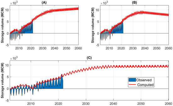
Figure 18.
Simulated vs. observed groundwater storage changes in the Goulbi Maradi aquifer using the last 5 years’ average recharge value, with a 20%, 30%, and 22% increase in pumping for panels (A), (B), and (C), respectively.
5.2.2. Scenario 2: 10-Year Average Recharge
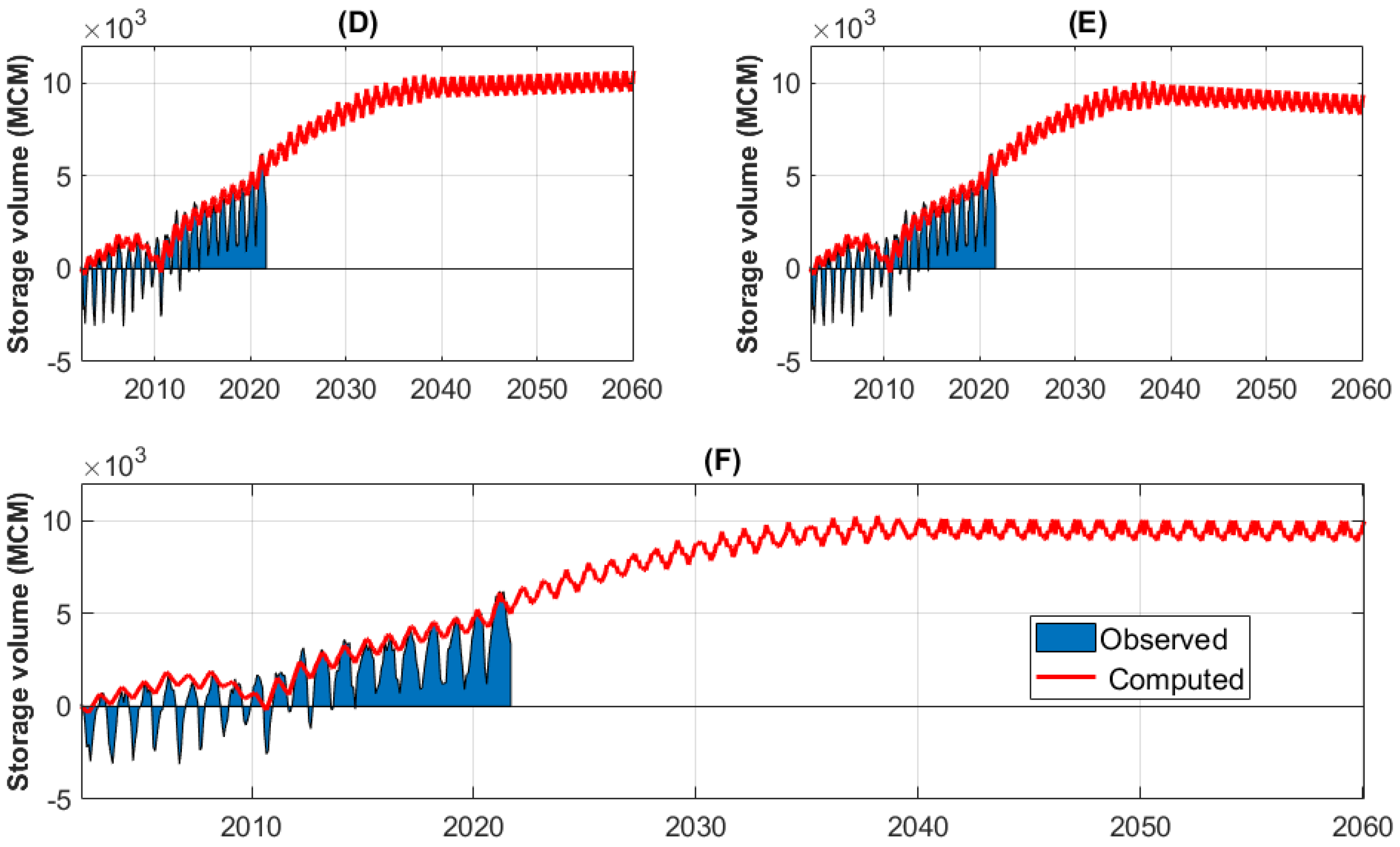
For scenario 2, we projected the average recharge rate determined over the last 10 years of the calibration phase into the future, which is also a higher recharge rate. Figure 19 shows the results of this scenario. Panels D and E correspond to pumping increases of 20% and 25%, respectively, over the first 20 years, with pumping held constant in the last 20 years. These results bracket a balanced solution, shown in Panel F, which represent a 24% increase in pumping.
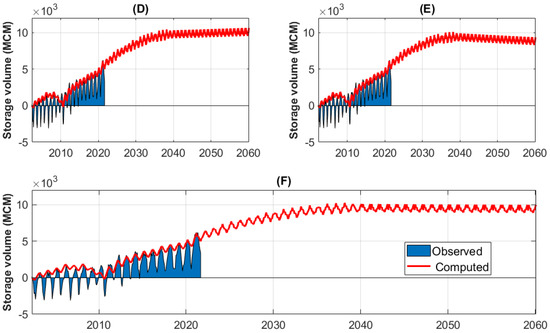
Figure 19.
Simulated vs. observed groundwater storage changes in the Goulbi Maradi aquifer using the last 10 years’ average recharge value, with a 20%, 25%, and 24% increase in pumping for panels (D), (E), and (F), respectively.
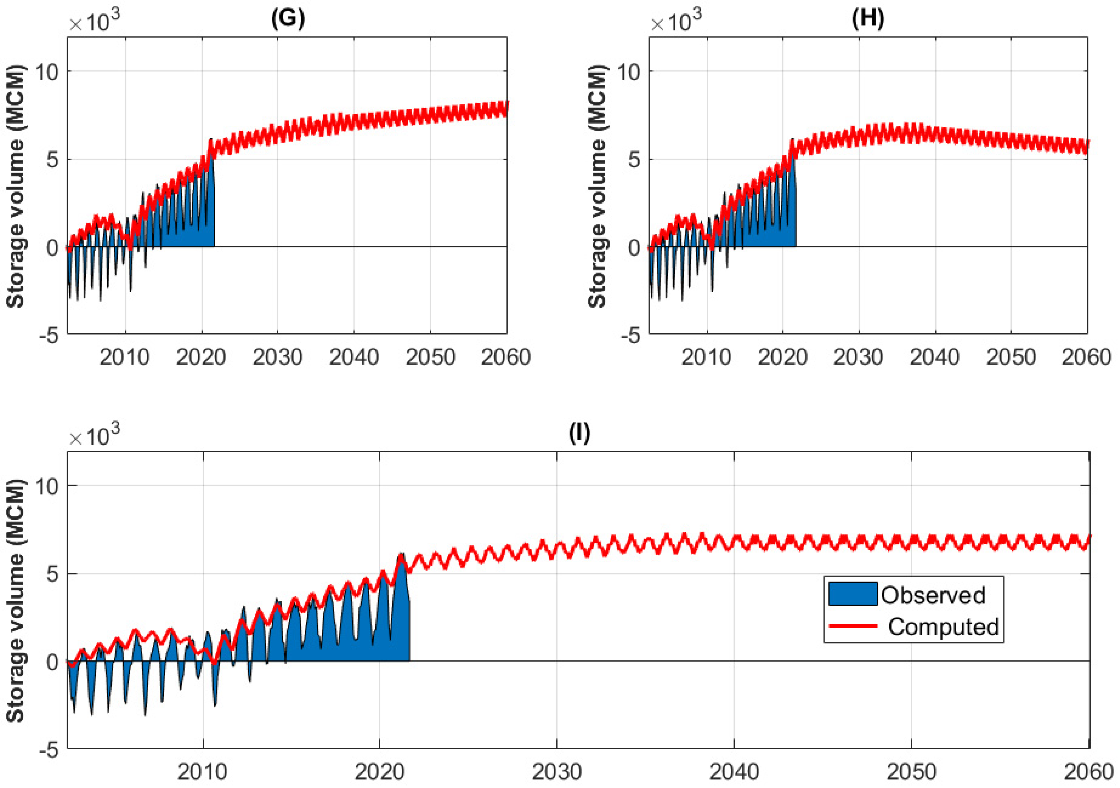
5.2.3. Scenario 3: 20-Year Average Recharge
For our third scenario, we used a recharge value corresponding to the average recharge over the entire 20-year calibration range (Figure 20). This is the most conservative of the three scenarios as it has the lowest recharge. Panels G and H represent increased pumping of 5% and 10% per year for the first 20 years, then constant for the next 20 years, respectively. Like the previous two scenarios, these results indicate a slight increase in storage for the 5% increase, and a decrease in storage for the 10% increase. Panel I depicts a 7% increase in pumping over the first 20 years with pumping held constant the last 20 years. Under this scenario, storage is essentially constant in the latter portion of the scenario.
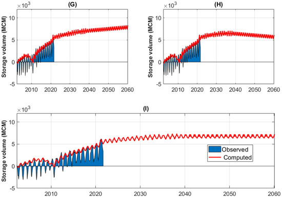
Figure 20.
Simulated vs. observed groundwater storage changes in the Goulbi Maradi aquifer using the last 20 years’ average recharge value, with a 5%, 10%, and 7% increase in pumping for panels (G), (H), and (I), respectively.
6. Conclusions
We developed a transient groundwater model of the Goulbi Maradi aquifer in southern Niger, an area with limited water level data and almost no water extraction data. We successfully used Earth observations to estimate water withdrawals and recharge to calibrate the model. This approach compensates for a severe scarcity of groundwater data in the region, a unique feature of this study. We used data from the GRACE mission to estimate groundwater storage changes over the period of 2002 to 2021 to estimate aquifer storage changes and recharge rates. We used these estimated recharge rates and storage changes to compute well pumping rates in the region during model calibration. We adjusted recharge and withdrawal extraction to calibrate the model estimated heads to the limited observed heads over the time period when data were available (2002–2009). We validated this model by comparing aquifer storage changes over the subsequent 10 years with no observed data to storage changes computed using GRACE data.
We used the calibrated model to evaluate the sustainability of various groundwater development strategies over the next 40 years. We evaluated three different scenarios that varied recharge rates and pumping rates. We showed that groundwater withdrawals could be increased as much as 7%, 22%, or 24% for 20 years, then held constant, depending on assumed recharge rates. This is not a detailed analysis of groundwater management strategies but does provide guidance for future studies that perform a more detailed analysis.
There is still a significant amount of uncertainty with the model. Even though we were able to use GRACE data to calibrate the flow budget, the GRACE results come from a set of grid cells that cover a region much larger than the Goulbi Maradi aquifer. We show that we cannot match the GRACE data exactly using reasonable parameters. We attribute this to the fact that GRACE-derived storage changes include dry regions with little groundwater resources. This course spatial resolution is a general limitation of GRACE data for specific aquifer studies. We believe this model could be refined and improved over time as investments are made in the region in terms of monitoring well development, data collection, additional methods for estimating recharge, etc. Future research could also involve performing stochastic simulations of the aquifer response to various groundwater development scenarios to illustrate the impact of uncertainty on model predictions.
Author Contributions
Conceptualization, S.A.B., N.L.J., G.P.W. and B.M.; methodology, S.A.B., N.L.J. and G.P.W.; software, S.A.B., N.L.J. and G.P.W.; investigation, S.A.B., N.L.J., G.P.W., B.M. and J.B.; writing—original draft preparation, S.A.B. and N.L.J.; writing—review and editing, G.P.W., N.L.J., S.A.B., B.M., J.B., E.J.N. and D.P.A.; supervision, N.L.J., G.P.W., E.J.N. and D.P.A.; project administration, N.L.J. and G.P.W.; funding acquisition, N.L.J., G.P.W. and B.M. All authors have read and agreed to the published version of the manuscript.
Funding
This work was supported by the NASA ROSES SERVIR Applied Research Grant 80NSSC20K0155 and from USAID under the SERVIR West Africa hub.
Data Availability Statement
The MODFLOW model files generated in this study are accessible for download at the following link: https://ggst.readthedocs.io/en/latest/ (accessed on 29 October 2023). This site also provides comprehensive, step-by-step instructions for adjusting the model inputs to facilitate predictive simulations with diverse assumptions concerning recharge and pumping rates.
Conflicts of Interest
The authors declare no conflict of interest.
References
- INS-Niger. Recensement Général de La Population et de l’Habitat—Etat et Structure de la Population du Niger en 2012; Institute National de la Statistique: Niamey, Niger, 2015; 88p. [Google Scholar]
- Issoufou Ousmane, B.; Nazoumou, Y.; Favreau, G.; Abdou Babaye, M.S.; Abdou Mahaman, R.; Boucher, M.; Issoufa, I.; Lawson, F.M.A.; Vouillamoz, J.-M.; Legchenko, A.; et al. Changes in Aquifer Properties along a Seasonal River Channel of the Niger Basin: Identifying Groundwater Recharge Pathways in a Dryland Environment. J. Afr. Earth Sci. 2023, 197, 104742. [Google Scholar] [CrossRef]
- Andres, L.; Dambo, L.; Bode, S.; Baboussouna, A.; Yamba, B.; Lebailly, P. Irrigated Food Systems in Maradi, Republic of Niger: A Comparison between Operating Accounts. In Proceedings of the VII International Scientific Agriculture Symposium “AGROSYM 2016”, East Sarajevo, Bosnia, 6–9 October 2016; pp. 2763–2768. [Google Scholar]
- Yahouza, L.; Sandao, I.; Ousmane, B. Framework of the StudyContribution of Stable Isotopes of Water (18O and 2H) to the Characterization of Goulbi N’kaba Valley Aquifer, Region of Maradi in the Republic of Niger. Int. J. Hydro 2018, 2, 560–565. [Google Scholar]
- OCHA. Niger Maradi-Situation des Inondations, au 4 Octobre 2021-Niger|ReliefWeb. Available online: https://reliefweb.int/report/niger/niger-maradi-situation-des-inondations-au-04-octobre-2021 (accessed on 1 August 2023).
- Descloitres, M.; Chalikakis, K.; Legchenko, A.; Moussa, A.M.; Genthon, P.; Favreau, G.; Le Coz, M.; Boucher, M.; Oï, M. Investigation of Groundwater Resources in the Komadugu Yobe Valley (Lake Chad Basin, Niger) Using MRS and TDEM Methods. J. Afr. Earth Sci. 2013, 87, 71–85. [Google Scholar] [CrossRef]
- Qian, J.; Zhou, X.; Zhan, H.; Dong, H.; Ma, L. Numerical Simulation and Evaluation of Groundwater Resources in a Fractured Chalk Aquifer: A Case Study in Zinder Well Field, Niger. Env. Earth Sci. 2014, 72, 3053–3065. [Google Scholar] [CrossRef]
- Werth, S.; White, D.; Bliss, D.W. GRACE Detected Rise of Groundwater in the Sahelian Niger River Basin. J. Geophys. Res. Solid Earth 2017, 122, 10459–10477. [Google Scholar] [CrossRef]
- Jackson, T.J. Remote Sensing of Soil Moisture: Implications for Groundwater Recharge. Hydrogeol. J. 2002, 10, 40–51. [Google Scholar] [CrossRef]
- Brunner, P.; Bauer, P.; Eugster, M.; Kinzelbach, W. Using Remote Sensing to Regionalize Local Precipitation Recharge Rates Obtained from the Chloride Method. J. Hydrol. 2004, 294, 241–250. [Google Scholar] [CrossRef]
- Schmid, T.; Koch, M.; Gumuzzio, J. Multisensor Approach to Determine Changes of Wetland Characteristics in Semiarid Environments (Central Spain). IEEE Trans. Geosci. Remote Sens. 2005, 43, 2516–2525. [Google Scholar] [CrossRef]
- OSS. Système Aquifère d’Iullemeden: Gestion Concertée Des Ressources En Eau Partagées d’un Aquifère Transfrontalier Sahélien|Bienvenue à l’Observatoire Du Sahara et Du Sahel. Available online: http://www.oss-online.org/fr/publications/OSS-SAI-CS1 (accessed on 7 December 2022).
- Durand, A.; Icole, M.; Bieda, S. Sediments Et Climats Quaternaires Du Sahel Central: Exemple de La Vallee de Maradi Niger Meridional. Cah. ORSTOM Série Géologie 1981, 12, 77–90. [Google Scholar]
- OSS. Iullemeden Aquifer System: Hydrogeological Model—Volume III; Sahara and Sahel Observatory: Tunis, Tunisia, 2011; 89p. [Google Scholar]
- Barbosa, S.A.; Pulla, S.T.; Williams, G.P.; Jones, N.L.; Mamane, B.; Sanchez, J.L. Evaluating Groundwater Storage Change and Recharge Using GRACE Data: A Case Study of Aquifers in Niger, West Africa. Remote Sens. 2022, 14, 1532. [Google Scholar] [CrossRef]
- Scanlon, B.R.; Rateb, A.; Anyamba, A.; Kebede, S.; MacDonald, A.M.; Shamsudduha, M.; Small, J.; Sun, A.; Taylor, R.G.; Xie, H. Linkages between GRACE Water Storage, Hydrologic Extremes, and Climate Teleconnections in Major African Aquifers. Environ. Res. Lett. 2022, 17, 014046. [Google Scholar] [CrossRef]
- Bonsor, H.C.; Shamsudduha, M.; Marchant, B.P.; MacDonald, A.M.; Taylor, R.G. Seasonal and Decadal Groundwater Changes in African Sedimentary Aquifers Estimated Using GRACE Products and LSMs. Remote Sens. 2018, 10, 904. [Google Scholar] [CrossRef]
- NASA JPL. Prolific Earth Gravity Satellites End Science Mission. Available online: https://www.jpl.nasa.gov/news/prolific-earth-gravity-satellites-end-science-mission (accessed on 4 March 2020).
- Landerer, F.W.; Flechtner, F.M.; Save, H.; Webb, F.H.; Bandikova, T.; Bertiger, W.I.; Bettadpur, S.V.; Byun, S.H.; Dahle, C.; Dobslaw, H. Extending the Global Mass Change Data Record: GRACE Follow-On Instrument and Science Data Performance. Geophys. Res. Lett. 2020, 47, e2020GL088306. [Google Scholar] [CrossRef]
- Callery, S. GRACE-FO Launches Aboard a SpaceX Falcon 9. Available online: https://gracefo.jpl.nasa.gov/resources/77/grace-fo-launches-aboard-a-spacex-falcon-9 (accessed on 4 March 2020).
- Tapley, B.D.; Bettadpur, S.; Ries, J.C.; Thompson, P.F.; Watkins, M.M. GRACE Measurements of Mass Variability in the Earth System. Science 2004, 305, 503–505. [Google Scholar] [CrossRef] [PubMed]
- Dunbar, B. “GRACE Mission”. Spacecraft. Available online: http://www.nasa.gov/mission_pages/Grace/spacecraft/index.html (accessed on 1 May 2023).
- Dunbar, B. “GRACE Mission” Mission Overview. Available online: http://www.nasa.gov/mission_pages/Grace/overview/index.html (accessed on 29 January 2022).
- Scanlon, B.R.; Zhang, Z.; Save, H.; Wiese, D.N.; Landerer, F.W.; Long, D.; Longuevergne, L.; Chen, J. Global Evaluation of New GRACE Mascon Products for Hydrologic Applications. Water Resour. Res. 2016, 52, 9412–9429. [Google Scholar] [CrossRef]
- Chen, J.L.; Wilson, C.R.; Tapley, B.D. The 2009 Exceptional Amazon Flood and Interannual Terrestrial Water Storage Change Observed by GRACE. Water Resour. Res. 2010, 46. [Google Scholar] [CrossRef]
- Reager, J.T.; Famiglietti, J.S. Characteristic Mega-Basin Water Storage Behavior Using GRACE. Water Resour. Res. 2013, 49, 3314–3329. [Google Scholar] [CrossRef] [PubMed]
- Idowu, D.; Zhou, W. Performance Evaluation of a Potential Component of an Early Flood Warning System—A Case Study of the 2012 Flood, Lower Niger River Basin, Nigeria. Remote Sens. 2019, 11, 1970. [Google Scholar] [CrossRef]
- Chen, X.; Jiang, J.; Li, H. Drought and Flood Monitoring of the Liao River Basin in Northeast China Using Extended GRACE Data. Remote Sens. 2018, 10, 1168. [Google Scholar] [CrossRef]
- Sun, Z.; Zhu, X.; Pan, Y.; Zhang, J. Assessing Terrestrial Water Storage and Flood Potential Using GRACE Data in the Yangtze River Basin, China. Remote Sens. 2017, 9, 1011. [Google Scholar] [CrossRef]
- Leblanc, M.J.; Tregoning, P.; Ramillien, G.; Tweed, S.O.; Fakes, A. Basin-Scale, Integrated Observations of the Early 21st Century Multiyear Drought in Southeast Australia. Water Resour. Res. 2009, 45. [Google Scholar] [CrossRef]
- Chen, J.L.; Wilson, C.R.; Tapley, B.D.; Longuevergne, L.; Yang, Z.L.; Scanlon, B.R. Recent La Plata Basin Drought Conditions Observed by Satellite Gravimetry. J. Geophys. Res. Atmos. 2010, 115. [Google Scholar] [CrossRef]
- Paredes-Trejo, F.; Barbosa, H.A.; Giovannettone, J.; Kumar, T.V.; Thakur, M.K.; Buriti, C.d.O.; Uzcátegui-Briceño, C. Drought Assessment in the São Francisco River Basin Using Satellite-Based and Ground-Based Indices. Remote Sens. 2021, 13, 3921. [Google Scholar] [CrossRef]
- Tian, K.; Wang, Z.; Li, F.; Gao, Y.; Xiao, Y.; Liu, C. Drought Events over the Amazon River Basin (1993–2019) as Detected by the Climate-Driven Total Water Storage Change. Remote Sens. 2021, 13, 1124. [Google Scholar] [CrossRef]
- Shahzaman, M.; Zhu, W.; Ullah, I.; Mustafa, F.; Bilal, M.; Ishfaq, S.; Nisar, S.; Arshad, M.; Iqbal, R.; Aslam, R.W. Comparison of Multi-Year Reanalysis, Models, and Satellite Remote Sensing Products for Agricultural Drought Monitoring over South Asian Countries. Remote Sens. 2021, 13, 3294. [Google Scholar] [CrossRef]
- Wang, W.; Shen, Y.; Wang, F.; Li, W. Two Severe Prolonged Hydrological Droughts Analysis over Mainland Australia Using GRACE Satellite Data. Remote Sens. 2021, 13, 1432. [Google Scholar] [CrossRef]
- Kalu, I.; Ndehedehe, C.E.; Okwuashi, O.; Eyoh, A.E. Assessing Freshwater Changes over Southern and Central Africa (2002–2017). Remote Sens. 2021, 13, 2543. [Google Scholar] [CrossRef]
- Chen, Z.; Zhang, X.; Chen, J. Monitoring Terrestrial Water Storage Changes with the Tongji-Grace2018 Model in the Nine Major River Basins of the Chinese Mainland. Remote Sens. 2021, 13, 1851. [Google Scholar] [CrossRef]
- Nicolas, J.; Verdun, J.; Boy, J.-P.; Bonhomme, L.; Asri, A.; Corbeau, A.; Berthier, A.; Durand, F.; Clarke, P. Improved Hydrological Loading Models in South America: Analysis of GPS Displacements Using M-SSA. Remote Sens. 2021, 13, 1605. [Google Scholar] [CrossRef]
- McStraw, T.C.; Pulla, S.T.; Jones, N.L.; Williams, G.P.; David, C.H.; Nelson, J.E.; Ames, D.P. An Open-Source Web Application for Regional Analysis of GRACE Groundwater Data and Engaging Stakeholders in Groundwater Management. JAWRA J. Am. Water Resour. Assoc. 2021, 58, 1002–1016. [Google Scholar] [CrossRef]
- Rodell, M.; Famiglietti, J.S. The Potential for Satellite-Based Monitoring of Groundwater Storage Changes Using GRACE: The High Plains Aquifer, Central US. J. Hydrol. 2002, 263, 245–256. [Google Scholar] [CrossRef]
- Mehrnegar, N.; Jones, O.; Singer, M.B.; Schumacher, M.; Jagdhuber, T.; Scanlon, B.R.; Rateb, A.; Forootan, E. Exploring Groundwater and Soil Water Storage Changes across the CONUS at 12.5 Km Resolution by a Bayesian Integration of GRACE Data into W3RA. Sci. Total Environ. 2021, 758, 143579. [Google Scholar] [CrossRef]
- Sun, A.Y.; Green, R.; Swenson, S.; Rodell, M. Toward Calibration of Regional Groundwater Models Using GRACE Data. J. Hydrol. 2012, 422–423, 1–9. [Google Scholar] [CrossRef]
- Scanlon, B.R.; Longuevergne, L.; Long, D. Ground Referencing GRACE Satellite Estimates of Groundwater Storage Changes in the California Central Valley, USA. Water Resour. Res. 2012, 48. [Google Scholar] [CrossRef]
- Voss, K.A.; Famiglietti, J.S.; Lo, M.; De Linage, C.; Rodell, M.; Swenson, S.C. Groundwater Depletion in the Middle East from GRACE with Implications for Transboundary Water Management in the Tigris-Euphrates-Western Iran Region. Water Resour. Res. 2013, 49, 904–914. [Google Scholar] [CrossRef] [PubMed]
- Strassberg, G.; Scanlon, B.R.; Chambers, D. Evaluation of Groundwater Storage Monitoring with the GRACE Satellite: Case Study of the High Plains Aquifer, Central United States. Water Resour. Res. 2009, 45. [Google Scholar] [CrossRef]
- Wahr, J.; Molenaar, M.; Bryan, F. Time Variability of the Earth’s Gravity Field: Hydrological and Oceanic Effects and Their Possible Detection Using GRACE. J. Geophys. Res. Solid Earth 1998, 103, 30205–30229. [Google Scholar] [CrossRef]
- Lemon, A.M.; Jones, N.L. Building Solid Models from Boreholes and User-Defined Cross-Sections. Comput. Geosci. 2003, 29, 547–555. [Google Scholar] [CrossRef]
- Purdy, A.J.; David, C.H.; Sikder, M.S.; Reager, J.T.; Chandanpurkar, H.A.; Jones, N.L.; Matin, M.A. An Open-Source Tool to Facilitate the Processing of GRACE Observations and GLDAS Outputs: An Evaluation in Bangladesh. Front. Environ. Sci. 2019, 7, 00155. [Google Scholar] [CrossRef]
- Syed, T.H.; Famiglietti, J.S.; Rodell, M.; Chen, J.; Wilson, C.R. Analysis of Terrestrial Water Storage Changes from GRACE and GLDAS. Water Resour. Res. 2008, 44. [Google Scholar] [CrossRef]
- Famiglietti, J.S.; Lo, M.; Ho, S.L.; Bethune, J.; Anderson, K.J.; Syed, T.H.; Swenson, S.C.; de Linage, C.R.; Rodell, M. Satellites Measure Recent Rates of Groundwater Depletion in California’s Central Valley. Geophys. Res. Lett. 2011, 38. [Google Scholar] [CrossRef]
- Rodell, M.; Velicogna, I.; Famiglietti, J.S. Satellite-Based Estimates of Groundwater Depletion in India. Nature 2009, 460, 999–1002. [Google Scholar] [CrossRef] [PubMed]
- Richey, A.S.; Thomas, B.F.; Lo, M.-H.; Reager, J.T.; Famiglietti, J.S.; Voss, K.; Swenson, S.; Rodell, M. Quantifying Renewable Groundwater Stress with GRACE. Water Resour. Res. 2015, 51, 5217–5238. [Google Scholar] [CrossRef]
- Khaki, M.; Forootan, E.; Kuhn, M.; Awange, J.; Papa, F.; Shum, C.K. A Study of Bangladesh’s Sub-Surface Water Storages Using Satellite Products and Data Assimilation Scheme. Sci. Total Environ. 2018, 625, 963–977. [Google Scholar] [CrossRef]
- Xiao, R.; He, X.; Zhang, Y.; Ferreira, V.; Chang, L. Monitoring Groundwater Variations from Satellite Gravimetry and Hydrological Models: A Comparison with in-Situ Measurements in the Mid-Atlantic Region of the United States. Remote Sens. 2015, 7, 686–703. [Google Scholar] [CrossRef]
- Nanteza, J.; Reager, J.T.; Richey, A.S.; Liu, H.; Famiglietti, J.S.; Rodell, M. The Link between Surface and Groundwater Variations over East Africa Using GRACE and Altimetry Data. In Proceedings of the AGU 2012, San Francisco, CA, USA, 3–7 December 2012. [Google Scholar]
- Joodaki, G.; Wahr, J.; Swenson, S. Estimating the Human Contribution to Groundwater Depletion in the Middle East, from GRACE Data, Land Surface Models, and Well Observations. Water Resour. Res. 2014, 50, 2679–2692. [Google Scholar] [CrossRef]
- Ali, S.; Liu, D.; Fu, Q.; Cheema, M.J.M.; Pham, Q.B.; Rahaman, M.; Dang, T.D.; Anh, D.T. Improving the Resolution of GRACE Data for Spatio-Temporal Groundwater Storage Assessment. Remote Sens. 2021, 13, 3513. [Google Scholar] [CrossRef]
- Zhang, J.; Liu, K.; Wang, M. Seasonal and Interannual Variations in China’s Groundwater Based on GRACE Data and Multisource Hydrological Models. Remote Sens. 2020, 12, 845. [Google Scholar] [CrossRef]
- Tiwari, V.M.; Wahr, J.; Swenson, S. Dwindling Groundwater Resources in Northern India, from Satellite Gravity Observations. Geophys. Res. Lett. 2009, 36. [Google Scholar] [CrossRef]
- Wu, Q.; Si, B.; He, H.; Wu, P. Determining Regional-Scale Groundwater Recharge with GRACE and GLDAS. Remote Sens. 2019, 11, 154. [Google Scholar] [CrossRef]
- Lubczynski, M.W.; Gurwin, J. Integration of Various Data Sources for Transient Groundwater Modeling with Spatio-Temporally Variable Fluxes—Sardon Study Case, Spain. J. Hydrol. 2005, 306, 71–96. [Google Scholar] [CrossRef]
- Healy, R.W.; Cook, P.G. Using Groundwater Levels to Estimate Recharge. Hydrogeol. J. 2002, 10, 91–109. [Google Scholar] [CrossRef]
- Nimmo, J.R.; Horowitz, C.; Mitchell, L. Discrete-Storm Water-Table Fluctuation Method to Estimate Episodic Recharge. Groundwater 2015, 53, 282–292. [Google Scholar] [CrossRef] [PubMed]
- Chaperon, P. Note Hydrologique sur le Goulbi de Maradi et le lac de Madarounfa (Niger); ORSTOM: Paris, France, 1971; 26p. [Google Scholar]
- Vannucci, R.; Calvino, F.; Cortesogno, L.; Tolomeo, L. Jurassic Volcanism Findings in Sokoto State (NW-Nigeria). J. Afr. Earth Sci. 1989, 9, 245–258. [Google Scholar] [CrossRef]
- Lutz, A.; Thomas, J.M.; Pohll, G.; Keita, M.; McKay, W.A. Sustainability of Groundwater in Mali, West Africa. Env. Geol 2009, 58, 1441. [Google Scholar] [CrossRef]
- USGS. User’s Documentation for MODFLOW-96, an Update to the U.S. Geological Survey Modular Finite-Difference Ground-Water Flow Model—Open-File Report 96-485; United States Geologic Survey: Reston, VA, USA, 1996; 63p. [Google Scholar]
- GMS:MODFLOW-XMS Wiki. Available online: https://www.xmswiki.com/wiki/GMS:MODFLOW (accessed on 30 April 2021).
- GMS:PEST-XMS Wiki. Available online: https://www.xmswiki.com/wiki/GMS:PEST (accessed on 19 July 2023).
- Earth Resources Observation and Science (EROS) Center. Global 30 Arc-Second Elevation (GTOPO30); EROS: Sioux Falls, SD, USA, 2017. [Google Scholar]
- Hydraulic Conductivity. Wikipedia. 2022. Available online: https://en.wikipedia.org/wiki/Hydraulic_conductivity (accessed on 29 October 2023).
- Karimi, L.; Motagh, M.; Entezam, I. Modeling Groundwater Level Fluctuations in Tehran Aquifer: Results from a 3D Unconfined Aquifer Model. Groundw. Sustain. Dev. 2019, 8, 439–449. [Google Scholar] [CrossRef]
- GMS 10.6 Tutorials. Available online: https://www.aquaveo.com/software/gms-learning-tutorials (accessed on 27 April 2022).
Disclaimer/Publisher’s Note: The statements, opinions and data contained in all publications are solely those of the individual author(s) and contributor(s) and not of MDPI and/or the editor(s). MDPI and/or the editor(s) disclaim responsibility for any injury to people or property resulting from any ideas, methods, instructions or products referred to in the content. |
© 2023 by the authors. Licensee MDPI, Basel, Switzerland. This article is an open access article distributed under the terms and conditions of the Creative Commons Attribution (CC BY) license (https://creativecommons.org/licenses/by/4.0/).

