Article

Large-Scale Crustal Deformation of the Tianshan Mountains, Xinjiang, from Sentinel-1 InSAR Observations (2015–2020)

1
School of Earth Sciences and Engineering, Hohai University, Nanjing 211100, China
2
Beijing Key Laboratory of Urban Spatial Information Engineering, Beijing Institute of Surveying and Mapping, Beijing 100038, China
3
School of Geodesy and Geomatics, Wuhan University, 129 Luoyu Road, Wuhan 430079, China
*
Author to whom correspondence should be addressed.
Remote Sens. 2023, 15(20), 4901; https://doi.org/10.3390/rs15204901
Submission received: 28 August 2023 / Revised: 25 September 2023 / Accepted: 3 October 2023 / Published: 10 October 2023

Abstract

:
In this paper, we address some questions with respect to the Tianshan Mountains that are necessary for understanding the present deformation rate in this region. A series of thrust nappe structures are distributed on the north and south sides of the Tianshan Mountains, and many of them are currently active. To analyze the deformation characteristics and movement rates of different fold-and-thrust belts on the northern and southern margins of Tianshan, we use InSAR observations (Sentinel-1A/B, 2015–2020) to produce a rate map for the entire observation period on four ascending and four descending tracks. In order to reduce phase artifacts, we reconstruct multi-temporal scenes with atmospheric-corrected and orbital-corrected interferograms via a small baseline subset. The results show that the Bolokenu-Aqikekuduke Fault exhibits a right-lateral strike-slip motion, with the western segment moving at about 4.95 ± 0.38 mm/yr and the eastern segment at approximately 2.34 ± 0.34 mm/yr. The Manas-Tugulu anticline in the northern fold-and-thrust belt reaches ~5–8 mm/yr at 86°E–86.5°, and the Qiulitage anticline in the south reaches ~6–9 mm/yr at ~83°–85°. The post-seismic time series cumulative displacement map of the Jinghe earthquake reveals no significant post-seismic deformation signal in the epicenter area. The Qiulitage thrust belt, situated within the fold-and-thrust belts flanking the Tianshan, features extensive thrust accompanied by a right-lateral strike-slip component. And the Manas-Tugulu anticline exhibits sustained deformation, including pronounced coseismic and post-seismic effects from the Hutubi earthquake. This study highlights the potential of a multi-temporal InSAR analysis and emphasizes future opportunities presented by new generations of SAR platforms with shorter revisit periods for quantifying the spatial and temporal behavior of post-seismic and interseismic periods.

1. Introduction

The Tianshan Orogenic Belt, also known as the Tianshan, is a significant east–west orogenic belt that spans the central part of Xinjiang province. Situated in the interior region of the Eurasian continent, the Tianshan Mountains were formed by a powerful collision between the Indian Plate and the Eurasian Plate during the Late Cenozoic. Earthquakes are scattered across the Tianshan area, creating varying degrees of seismic tectonic activity zones along active fault zones.
Since the Cenozoic era, the Qinghai–Tibet Plateau region has experienced significant horizontal compressive stress due to the collision between the India and Eurasia plates. This has resulted in pronounced crustal shortening and uplift deformation in the Tianshan Orogenic Belt. GPS observations have revealed that the maximum crustal shortening in the Tianshan region reaches 20 mm/year [1]. The piedmont areas of the northern and southern sides of the Tianshan orogenic belt exhibit thrust nappe structures. This region is characterized by strong tectonic activity, leading to frequent and significant earthquakes. Historical records indicate that over one hundred earthquakes Mw > 6.0 have occurred in the Tianshan area. These earthquakes mainly align with the large fault belts that have been active since the middle Pleistocene, such as the Manas earthquake of magnitude 7.7 that occurred on the Qingshuihe fault in 1906 and the Fuyun Mw 8.0 earthquake that occurred on the Erqisi fault (EQSF) in 1931.
Interferometric Synthetic Aperture Radar (InSAR) and time series analysis techniques have been established precisely for measuring ground deformation associated with interseismic strain accumulation [2,3,4,5,6]. This method can provide accurate near-field deformation measurements with high spatial coverage and resolution. In the Tianshan region, satellite-based InSAR has been successfully applied for coseismic deformation reconstruction, following the 2016 Mw 6.0 Hutubi earthquake [7] and 2017 Mw 6.3 Jinghe earthquake [8], as well as interseismic deformation extraction, such as time series InSAR observations of the South Atushi Fault and the Kashi Depression [9], in addition to the crustal deformation observations in the northwest corner of the Tarim Basin [10]. Due to the sparse GPS stations in the interior of the Tianshan Mountains and the low space resolution, it is difficult to study the movement characteristics of low-speed thrust and strike-slip faults in Tianshan using GPS observations. GPS combined with InSAR geodetic observation data is one of the most effective technical means to answer the structural deformation characteristics of Tianshan. Furthermore, InSAR has not been previously used to estimate the interseismic motion across the entire North and South Tianshan Faults in China.
In this paper, we specifically focus on InSAR measurements of the large-scale Eastern Tianshan Mountains region located within China, where the deformation is primarily driven by a far-field effect of the Indian plate and strong compression in the Pamir Plateau. Within the vast scope of the Chinese Tianshan Mountains, our study primarily concentrates on the structure along the northern and southern margins of the Tianshan range. To investigate crustal deformation in the Tianshan Mountain area more comprehensively, we carefully isolate weak tectonic signals from atmospheric phase screen (APS) noise and residual orbital ramps on four adjacent ascending tracks and four descending tracks. This approach enables us to obtain fine line-of-sight (LOS) velocity maps and three-dimensional rate maps covering the entire study period. Additionally, we validate the accuracy of our results by comparing them with GPS measurements for the 2015–2020 period. Our main objective is to improve the measurements of present-day crustal deformation in the Chinese Tianshan Mountains using five years of InSAR observations. In this work, we plan to combine these data with the available GPS data to refine our estimates of interseismic deformation zones along faults distributed within the thrust-and-fold belt zone. We aim to elucidate the local distribution of deformation along these faults and identify the factors contributing to the formation of geological and non-geological deformation areas in the region.

2. Active Tectonics of the Tianshan Region

The Chinese Tianshan, which formed as a result of the late Paleozoic collision between the Junggar Block (to the north) and the Tarim Craton (to the south), plays a crucial role and represents a significant segment of the south-western portion of the Central Asian Orogenic Belt [11]. Stretching approximately 1500 km in an east–west direction, the Chinese Tianshan Mountains have a north–south width of 250–350 km. The average altitude of the range is around 4000 m, with the highest peak reaching over 7000 m (Figure 1a). The northern and southern flanks of the Tianshan Mountains serve as transition zones between the Tarim block and the Junggar block, where significant regional deformation takes place. In the transition zone, many thrust fold structures developed, along with large-scale strike-slip faults that traverse Tianshan. The Bolokenu-Aqikekuduke fault (hereinafter referred to as BAF), an NW-trending strike-slip fault, cuts through the North Tianshan Mountains. The occurrence of nine earthquakes with magnitudes of six or above in Xinjiang since 2010 indicates the ongoing high level of crustal movement in this region [12].
Minimal east–west deformation is observed in the two orogenics, indicating predominant thrust motion along the Himalaya Main Thrust and the northern and southern frontal faults that delineate the Tianshan ranges. Wang et al. [1] computed translation and rotation rates of blocks, the Tibetan plateau pushes the Tarim block moving northward at a rate of –13.8 mm/yr, and the Jungger block is pushed north-northeastward at –6.4 mm/yr, simultaneously. The differential motion of these two blocks are absorbed by crustal shortening across the Tianshan ranges. The clockwise rotation of the Tarim block accommodates the westward increase in N-S shortening across the Tianshan ranges. Liu et al. [13] suggest that on the South Tianshan fault, the slip rates along the western and eastern segments are 9.5 ± 1.8 mm/yr and 3.9 ± 1.1 mm/yr, respectively, while the slip rate estimate of the eastern segment on the North Tianshan fault is higher (4.7 ± 1.1 mm/yr) than the western segment (3.7 ± 0.9 mm/yr). Geological results give apparent slip rates of 18.0 ± 6.0 mm/yr and 5.0 ± 2.5 mm/yr along the western segment and eastern segment, respectively [14]. Niu et al. [15] suggest that the compressive rate is 9.0 ± 1.0 mm/yr in the west and 4.1 ± 2.2 mm/yr in the eastern of South Tianshan, and 2.4 ± 0.6 mm/yr and 3.6 ± 1.7 mm/yr along the western and eastern segment of northern Tianshan. Yang et al. and Wang et al. [16,17] both divide Tianshan into south and north two parts, the results from [16] indicate that the slip rate is 10–13 mm/yr along South Tianshan and 2–12 mm/yr along North Tianshan, while [17] suggest compressive rates of 6.8 ± 0.8–2.9 ± 1.0 mm/yr and 6.3 ± 1.1 mm/yr in the South and North Tianshan, respectively. The movement rate of a single fault is not high in the Tianshan Mountains, generally during the range of 0.1–3 mm/yr. As the major active right-lateral strike-slip fault of the northern Tianshan region, Cambell et al. [18] reveal that the SE section of the Dzhungarian fault is almost pure strike slip, and the right-lateral strike-slip rate is 2.2 ± 0.8 mm/yr through field-based and satellite observations. The segment of fault may accumulate strain for a long time (e.g., thousands of years). Wu et al. [19] estimate that the crustal shortening rate caused by the Nalati fault is 0.8–1.1 mm/yr by means of field-based and trench excavation, indicating that obvious structural deformation exists in the interior of Tianshan orogen. From Nalati fault northward to the Kazakhstan Platform, many intermontane basins are distributed there, and the shortening strain is mainly concentrated between Tianshan and the Tarim Basin (e.g., Kash fault-Keping fault-Qiulitage fault: 3.28–6.38 mm/yr) and Junggar Basin (Manas fault: 3.44 mm/yr) [20]. In the northern marginal fold-and-thrust belt of the Tianshan Mountains, there exists a thin-skinned geometry, and the structural belt can be divided into three segments, referred to as the Borohoro Shan, Kuitun, and Bogda Shan segments from west to east, respectively (Figure 1b). The Kuitun segment consists of three belts of fold-and-thrust faults, and the southern belt of folds forms the main mountain front [21].
Previous studies have indicated that the Tianshan faults primarily experience compressive forces, with the main tectonic movement concentrated within the Tianshan fold belt. Understanding the fault slip rates within the fold belts is crucial for comprehending intracontinental orogenesis and assessing seismic hazard in the Tianshan region. However, it is important to note that the deformation of the Tianshan Mountains is complex and exhibits diachronic distribution. Consequently, drawing generalizations that are applicable to the entire mountain range based on studies conducted in isolated areas can be challenging, if not impossible. The diverse nature of the Tianshan Mountains necessitates comprehensive investigations spanning different regions to capture the full picture of deformation patterns and processes in this dynamic tectonic setting.

3. Data and InSAR Time Series Processing

In large-scale tectonic active regions, generating spatially continuous InSAR time series displacement maps presents a challenge, primarily due to the presence of long-wavelength atmospheric conditions covering small-magnitude tectonic signals. The strong coupling between the long-wavelength component of atmospheric artifacts and the tectonic signal makes it difficult to extract accurate deformation information. To overcome this challenge, it is necessary to incorporate external independent atmospheric data that can help improve the signal-to-noise ratio across faults. By integrating such data, we can enhance the reliability and precision of InSAR measurements, enabling us to better resolve the deformation signals and understand the dynamics of tectonic processes in these regions.

3.1. Data

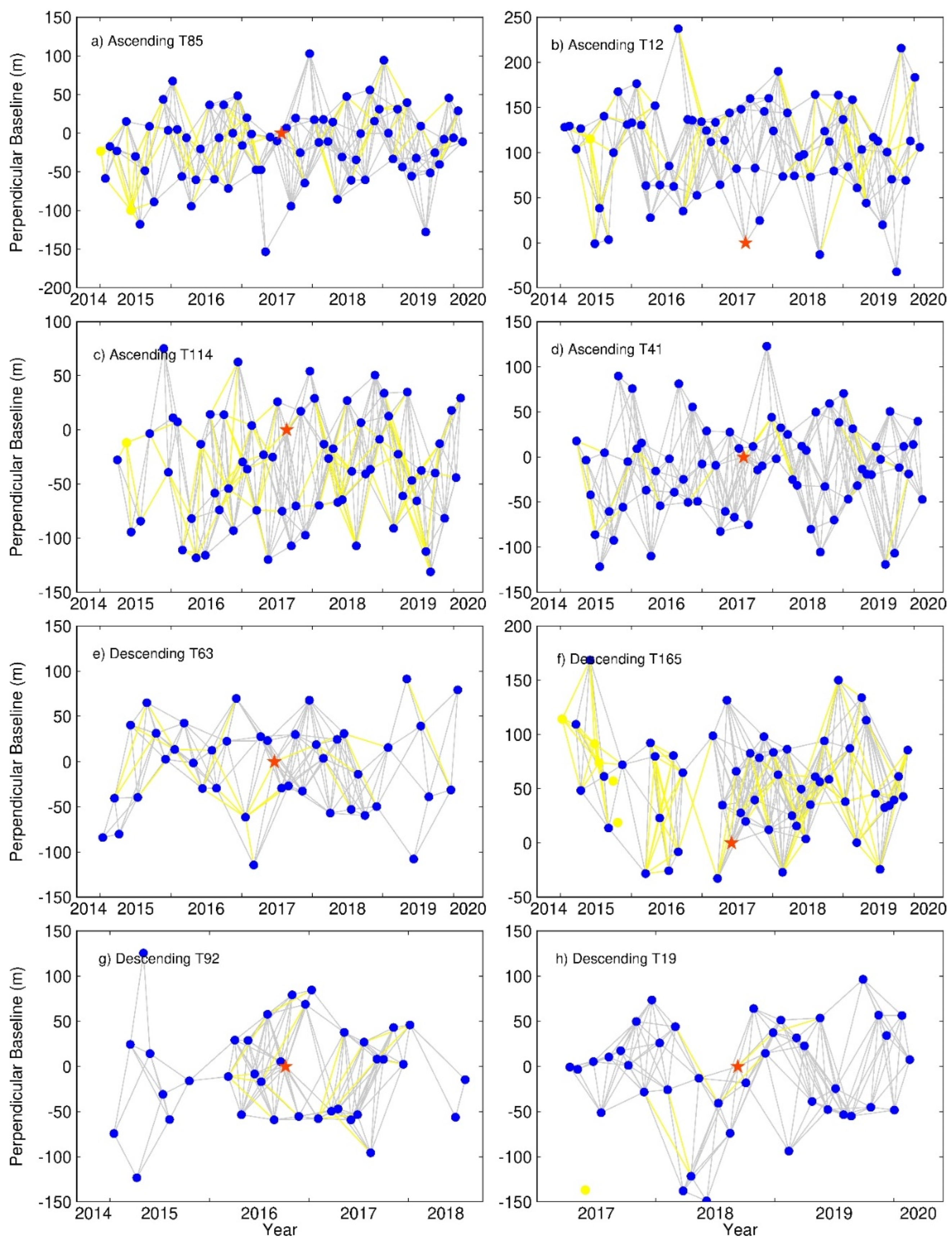
We collected the Sentinel-1A and 1B Interferometric Wide Swath images archive from the European Space Agency (ESA) on four overlapping ascending tracks (85, 12, 114, and 41) and four overlapping descending tracks (63, 165, 92, and 19), spanning approximately 5 years from January 2015 to early 2020 (Figure 1b and Figure 2, and Table S1). The data acquisition was conducted in the Terrain Observation by Progressive Scan (TOPS) mode in C-band radar with a wavelength of 56 mm. Each TOPS image consists of three subwaths, with a total swath width of ~500 km, providing a coverage of Chinese Tianshan. Each track comprises more than 38 acquisitions, ensuring comprehensive temporal coverage for our analysis. The single-reference SAR images, located in the middle of spatio-temporal baseline within each track, were selected as the public master images. The remaining images were registered and sampled into the public master image as slave images to maximize the coherence of the interferograms [22]. Before SAR image pairs interference, the output single look complex (SLC) images and the corresponding precise orbit data were imported simultaneously to reduce the orbital error and improve the accuracy of data positioning. Interferograms with baselines of less than 200 m were produced for each track using the GAMMA SAR and Interferometry software [23,24]. Optimal small temporal baselines and perpendicular baselines for interferometric networks were controlled within 150 days and 150 m that connect all acquisitions with redundancy. A filled three arc-second (90 m) resolution Shuttle Radar Topography Mission (SRTM) digital elevation model (DEM) [25] obtained from NASA’s Land Processes Distributed Active Archive Center (LP DAAC) was used to remove the topographic contribution to the interferometric phase changes. Phase ambiguities due to possible changes in topography over a time period of 20 years since the acquisition of the SRTM data (e.g., [26]) are assumed to be negligible given relatively small perpendicular baseline of Sentinel-1 interferograms [27]. To ensure the elimination of along-track Doppler centroid variation in the TOPS mode and avoid phase jumps between subsequent bursts, we maintained a co-registration accuracy of at least 0.001 pixels. [28]. Prior to phase unwrapping using the minimum cost flow algorithm (MCF) [29], we applied an adaptive power spectrum filter to reduce phase noise in the interferograms [30]. Additionally, a multi-look operation with 40 looks in range and 8 looks in azimuth directions was performed, resulting in a pixel dimension of approximately 93 m by 111 m.
GPS data used in this study were from [1], which is operated by CMONOC (Crustal Motion Observation Network of China) I and II project, and both with respect to the stable Eurasia-fixed Reference Frame. We utilized GPS observations to compare with our InSAR measurements. Figure 1b shows the compiled GPS velocities field for the study area. Details on GPS data processing, error sources, and corrections can be found in the references [1].

3.2. SBAS-InSAR with Atmospheric-Corrected Interferograms

The Chinese Tianshan Mountains encompass a diverse geological and climatic environment, characterized by desert oases as well as year-round glaciers. The complicated environment may cause severe incoherence between interferograms, posing challenges for data processing. Thus, the processing strategy adapted for this large-scale mountainous area can be roughly divided into two steps: (1) identify and remove interferograms with low average coherence and significant unwrapping errors; (2) use external atmospheric data and employ quadratic ramp fitting to mitigate residual errors. This approach helps to improve the accuracy and reliability of the processed data in the presence of the complex environmental conditions encountered in Chinese Tianshan Mountains.
We first calculate correlation coefficient of each interferogram, which with low average coherence (<0.6) are identified and removed. Then, the selected interferograms are checked for phase unwrapping errors by calculating the loop closure phase [31]. The phase of every interconnected image triplet follows Equation (1):
Φ 123 = ϕ 12 + ϕ 23 - ϕ 13
where ϕ 12 , ϕ 23 , and ϕ 13 are the interferograms formed from SAR images ϕ 1 , ϕ 2 , and ϕ 3 . The value of Φ 123 for a triplet close to zero indicates that the unwrapping errors can be ignorable between the three interferograms, while the value close to integer multiples of 2π means the presence of unwrapping errors in at least one of the triplets. We calculate the root mean square (RMS) of the loop phase image of each triplet and remove 106 interferograms where the RMS is greater than 0.6 rad of the loop [32].
After removing the interferograms with large unwrapping errors, there are still two main limitations affecting the extraction of low-amplitude tectonic signals in further analysis, atmospheric artifacts, and orbital ramp projected into the LOS direction (Figure S1). Variations in atmospheric delay are the results of radar path delays as waves refract through the troposphere, and they may reach tens of centimeters with a single-path LOS delay [33]. Considering that external independent atmospheric data can be used to correct the InSAR atmospheric delay effectively, we choose the Generic Atmospheric Correction Online Service for InSAR (GACOS) to mitigate atmospheric noise contamination [34,35,36]. Different from other external independent atmospheric data (e.g., MERIS, ECMWF) [37], GACOS provides tropospheric delay maps, which include both hydrostatic and wet components. Theses maps derived from the European Centre for Medium-Range Weather Forecasts (ECMWF) upscaled through the use of a DEM. The tropospheric zenith delay maps corresponding to each interferogram are differenced, then projected to the satellite LOS, and subtracted from the interferograms. Figure S2 shows the change in the standard deviation of all interferograms for each track after the GACOS correction has been applied. On average, more than or close to 50% of interferograms show a reduction in standard deviation for each track, which is associated with a reduction in atmospheric artifacts. Figure S3 illustrates the fitting curve of terrain and displacement before and after atmospheric correction. The deformation exists a linear correlation with the terrain height before correction. It is important to note that in short-time-span interferograms, no visible tectonic signal is expected due to the correction process focusing on mitigating atmospheric noise rather than capturing tectonic movements.
Following the atmospheric correction, the residual long-wavelength orbital ramps dominate the phase signal due to the imprecise orbit information. To avoid the effect of a ‘near-field’ gradient in ground deformation, we mask out the ‘near-field’ tectonic deformation signal to fit a quadratic orbit trend and remove from the GACOS-corrected interferograms [32,38]. After the atmospheric correction and orbital correction, the residual interferograms from independent chains of small-baseline datasets were used to create a rate map by SBAS-InSAR.
Next, we use a small-baseline time series analysis package, GIAnT software from JPL/Caltech, to generate cumulative LOS displacements and average velocities from interferograms selected. Cumulative LOS displacements are inverted for a linear velocity on the traditional piece-wise linear SBAS formulation [39], which is among the most common strategies to describe the ground displacements. In order to ensure measurement accuracy of SBAS-InSAR, only those pixels with good coherence in all unwrapped interferograms were included in the time series inversion. The flowchart for retrieving the InSAR ratemap in Chinese Tianshan Mountains is depicted in Figure S1, and the effects of atmospheric delay corrections are demonstrated in Figure S4.

3.3. InSAR LOS Velocity Decomposition

Monitoring the north–south compression in Tianshan is challenging. InSAR, due to satellite limitations, captures only one direction of surface deformation and is insensitive to the north–south deformation. GPS provides precise but sparse data. Combining InSAR and GPS offers a comprehensive view. We integrate GPS and InSAR data using the Watson et al. [32] method, relying on Wang and Shen’s [1] GPS data.
We firstly decompose the satellite LOS velocity into local geodetic coordinate velocities:
d L O S = sin θ cos α sin ( θ ) sin α cos ( θ ) d E d N d U
which θ represents the angle of incidence, α is the heading angle, and d E ,   d N   a n d   d U   represent East, North, and Up components, respectively. In this situation, we have two observations ( d A _ L O S   a n d   d D _ L O S ), one ascending and one descending, and three unknowns ( d U ,   d N   a n d   d E ), resulting in an underdetermined inverse problem. In order to find a unique solution to the problem, we need to add a further observation or prior constraint to one of the model parameters. We estimate northward contribution to InSAR LOS velocity by projecting the interpolated northward GNSS velocity field into the respective satellite LOS for each track. The projected velocity is then subtracted from each frame, leaving an LOS velocity that contains negligible long-wavelength north–south components. For the points observed from two viewing directions, we can simplify the equations, as shown in Equation (3):
d U d E = cos θ A sin θ A sin α A 3 π 2 cos θ D sin θ D sin α D 3 π 2 1 d A _ L O S d D _ L O S
We use weighted least squares to solve the above equation and estimate the decomposed velocities d U   a n d   d E for each point within two overlapping tracks.

4. Results

Our initial LOS InSAR velocity field is referenced relative to a stable pixel for each track. Here, we compute the average velocities for the whole observation period using the InSAR technique with four neighboring ascending and descending Sentinel-1 satellite SAR images.
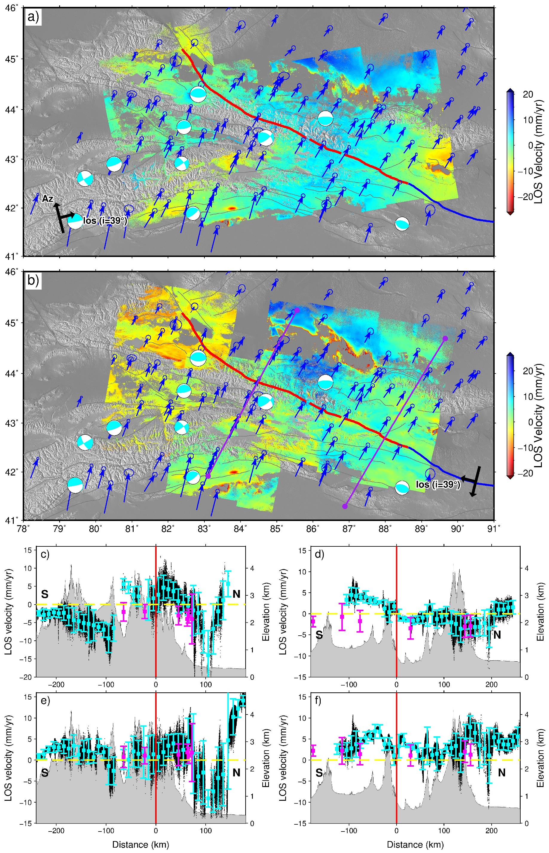
The final collage of 2015–2020 LOS surface velocity maps (Figure 3) shows, for the first time, a comprehensive view of the surface displacement field across the entire Tianshan Mountains. This dataset reveals previously unknown information about deformation patterns in the region. However, there are some areas where deformation is limited, such as the deserts and grasslands in Junggar and Tarim Basin, as well as the high-altitude snow areas in South Tianshan. As shown in Figure 3, the LOS deformation values across BAF are opposite in the ascending and descending tracks (negative range changes toward the satellite). The significant symbolic difference between velocity values of ascending and descending tracks is caused by two different satellite observation geometries and horizontal motions to the deformation field. The horizontal motions within the deformation field, such as tectonic movements or other geological processes, contribute to the differences in velocity values between two track directions. These factors emphasize the importance of considering multiple satellite observation geometries to obtain a more comprehensive understanding of the deformation field in the Tianshan Mountains. Figure 3 shows a substantial difference in the deformation rate on both sides of the BAF. The variations in the deformation rates exhibit a range, which may reach nearly 5 mm/yr. It is important to note that this range of variations may be even smaller if the displacement caused by non-geological structural factors is not taken into account. These non-geological structure factors can contribute to additional displacements and need to be considered when analyzing the deformation patterns in the Tianshan Mountains region. Junngar Basin is rich in groundwater resources, and numerous mountainous rivers (e.g., Kuitun River, Manasi River, and Hutubi River) converge here. Large-scale non-geological formations on the southern Junggar Basin (~84.5°E–88°E) are caused by the over-exploitation of groundwater in the oasis agricultural area, leading to the permanent loss of aquifers and ground subsidence [40]. The maximum cumulative deformation exceeds 300 mm from 2015 to 2020. On the eastern Tianshan, for the first time, we detect the regional-scale ground settlement caused by the exploitation of shale gas in Tuha Basin utilizing InSAR observation means. The subsidence range in this area can reach 300 mm. Similarly, numerous abnormal subsidence or uplift caused by a non-geological formation exist in other areas, including oil and gas exploitation, farmland reclamation, and salt mining. Excluding the impact of these non-geological activities, parts of the fault deformation signals in the Tianshan region—which is bounded by the northern Tianshan foreland thrust belt in the north, the southern Tianshan fold-and-thrust belt in the south, and high-altitude mountains in the middle—presents a sandwich structure and are clearly visible relative to surrounding area. As shown in Figure 3, values of LOS direction deformation in northern Tianshan foreland thrust belt near kuitun segment are positive in both ascending and descending tracks, and they are quite different in the southern Tianshan fold-and-thrust belt near kuche segment. For the rather complex deformation field in Tianshan, we create velocity profiles to investigate the regional deformation map. These profiles show the deformation gradient of faults and the distribution of crustal deformation throughout the study area. There is an obvious deformation gradient near the BAF fault, where the values of LOS alternate between positive and negative. This is consistent with the dextral strike-slip motion along the fault. Overall, the velocity profiles and deformation patterns reveal the complexity of the deformation field in the Tianshan region and provide valuable insights into the tectonic processes and fault motions occurring in this area.
In order to verify the validity of our InSAR results, comparisons between LOS-converted GPS velocities and InSAR observations are shown in Figure 3. In terms of the first order, the oblique cross-fault velocity profiles of InSAR and GPS data are generally consistent. For profiles AA’ in Figure 3c,e, the GPS measurements are obviously inconsistent with InSAR observations due to non-geological deformation caused by over-exploitation of groundwater in agricultural areas. Our results clearly demonstrate the effective interseismic deformation signals along the BAF fault and the correlation between the deformation with topographic relief. The profiles of topography reveal a decrease in width and complexity from west to east in the southern fold-and-thrust belt, while an increase is observed from west to east in the northern belt.
We showed the decomposed vertical and horizontal velocity fields during 2015–2020 in Figure 4. The east–west component deformation map does not feature a visible velocity gradient along the faults distributed in the Tianshan Mountains, implying that there is no obvious east–west strike-slip tectonic motion. The spatial distribution of the extracted east–west component is characterized by the eastward movement of the North Tarim Block and eastern Tianshan (longitude 86°–90°E), and the local ground movement reaches 3~5 mm/yr across the region. The vertical component velocity field exhibits localized and small-scale land subsidence, especially for numerous deformation areas of non-tectonic movement, with the maximum ground subsidence reaching up to ~15 mm/yr. A distinct velocity discontinuity is observed in the vertical component near the middle section of the BAF fault (longitude 84°–88°E). Both the northern and southern sides of the fault exhibit varying degrees of uplift, indicating a dominant compressional thrust movement near the fault. The north–south component deformation map reveals that the entire plate is moving northward as a whole, with generally higher movement rates on the west compared to the east. Both the northern and southern sides of Tianshan experience varying degrees of crustal shortening. These observations suggest that the orogenic process was characterized by the formation of thrust faults and extensive fold-and-thrust belts, resulting in the crustal shortening of mountains. Ultimately, this tectonic activity led to vertical crustal thickening and uplift. The highest part of Tianshan is adjacent to the active shortening area; this relation suggests that the major uplift of Tianshan is relatively young and the shortening in Tianshan is inhomogeneous and spatially distributed.

5. Discussion

5.1. Bolokenu-Aqikekuduke Fault

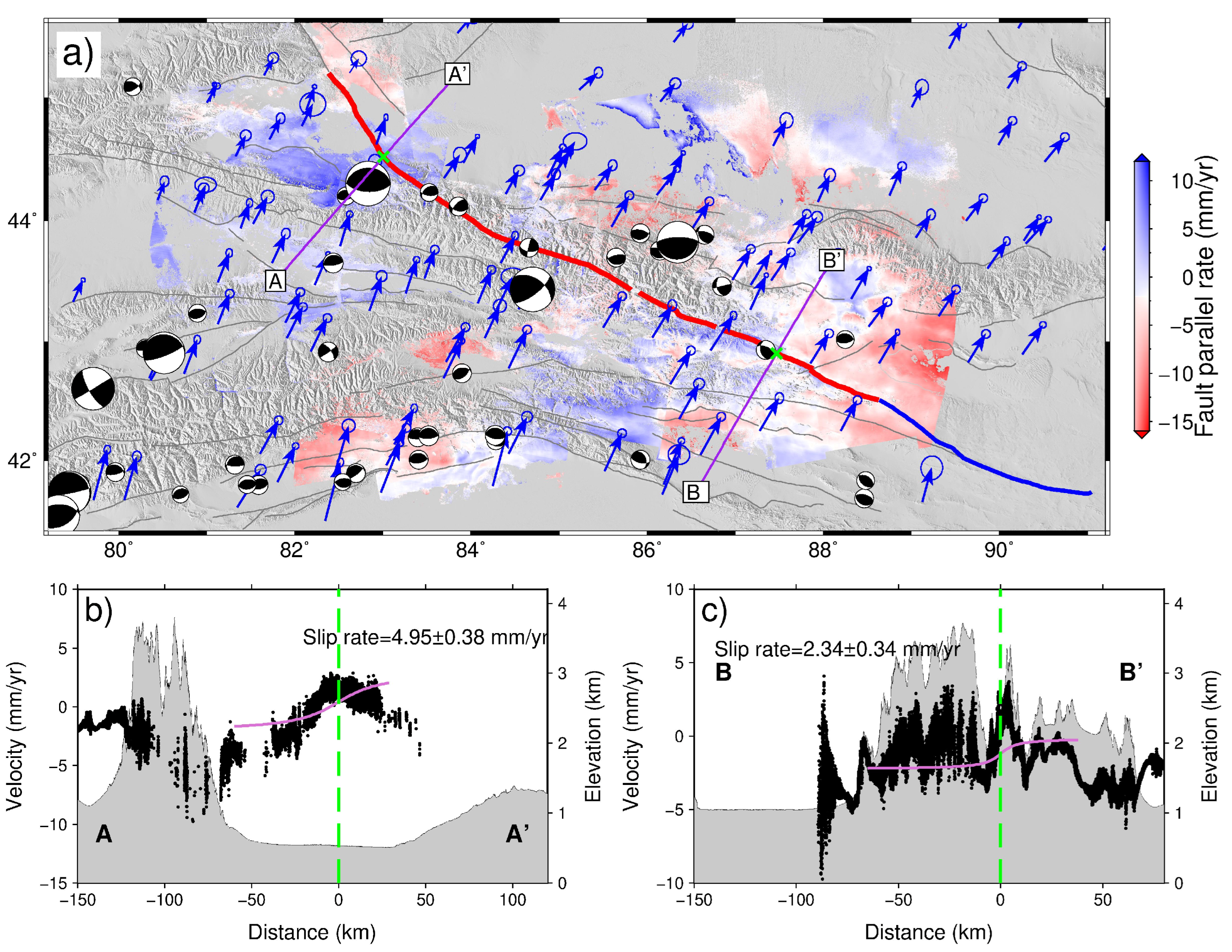
The fault-parallel velocity distribution, as shown in Figure 5a, is derived from 3D surface velocities by defining a well-defined fault strike. In this study, we employ an analytical 2D model to simulate interseismic deformation. Specially, we model two long horizontal velocity profiles, each approximately 200–250 km in length, perpendicular to the fault, as indicated in Figure 5a. To describe the interseismic accumulation of elastic strain along a near-perpendicular strike-slip BAF, we use a simple two-dimensional elastic screw dislocation model. This model helps us understand the build-up of strain along the fault during the interseismic period. In this model, the fault-parallel velocity ( V p a r a ) at a specific fault-perpendicular distance ( x B A F ) is expressed as a function of the fault slip rate, V B A F , locking depth, d B A F , and a static offset (c) in the curve:
V p a r a = V B A F π arctan ( x B A F d B A F ) + c
To find the best-fit solution for each model parameter and account for the trade-off between them, we utilize a Bayesian sampling algorithm with an affine invariant integrated Markov chain Monte Carlo (MCMC) sampler. This approach enables us to estimate the full covariance of the model parameters, providing a more comprehensive understanding of the uncertainties and interdependencies among these parameters. The MCMC sampler allows us to efficiently explore the parameter space and obtain robust estimates for the model parameters. Based on the information available in previously published results concerning the kinematics along the BAF fault, we incorporated prior constraints on its locking depth, while allowing the velocity V B A F to vary between 1 and 10 mm/yr. We assumed a uniform prior probability distribution for the curve’s static offset c, ranging from –10 to 10 mm/yr.
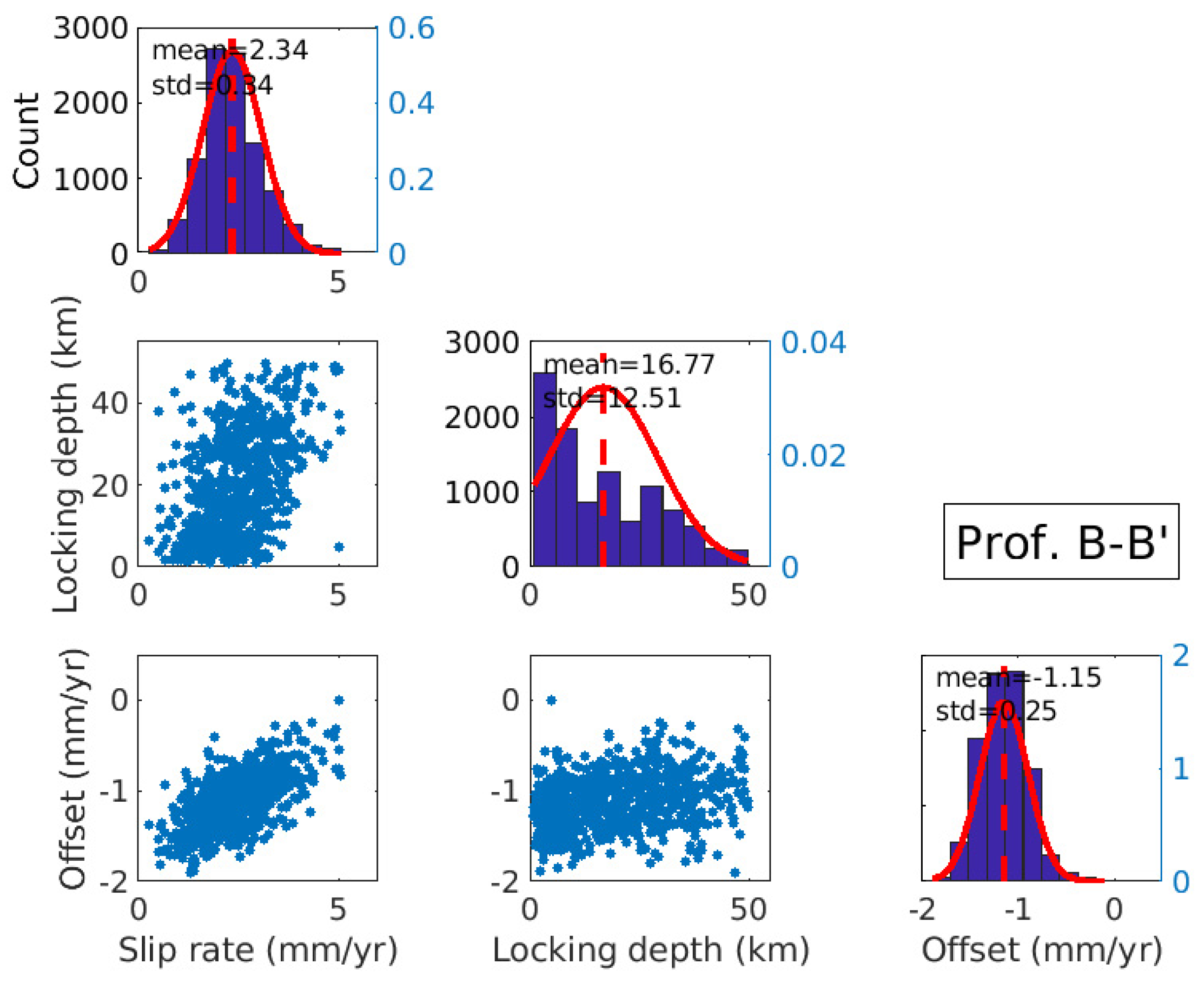
In our model’s MCMC sampler, we initiated 100 walkers to comprehensively explore the entire parameter space. Each of the InSAR profile models runs 100,000 iterations, producing more than 1000 independent random samples. For every unknown parameter, we computed the posterior probability density functions and the associated uncertainties for all model parameters. The Maximum A Posteriori (MAP) solutions were obtained as the most representative values for the model parameters.
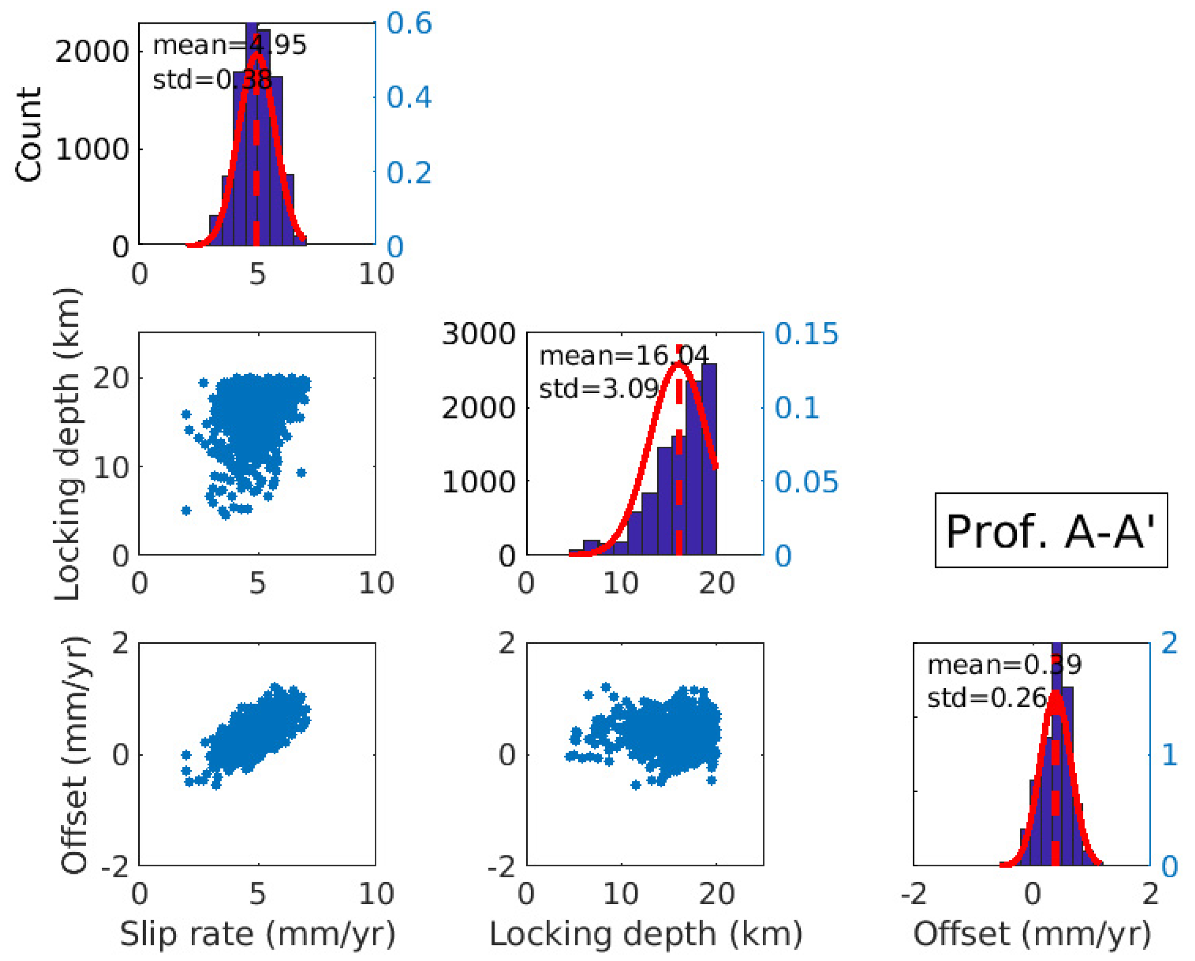
The BAF fault, spanning over 1000 km in length, has experienced varying degrees of structural deformation in different areas throughout the tectonic evolution of the entire northern Tianshan Mountain. We used the fault node at the intersection with the Kashgar River fault as the boundary to divide the BAF fault into two sections, the eastern and western segments. Simultaneously, we utilized a screw dislocation model to investigate the primary processes accounting for the InSAR velocities observed from 2015 to 2020. The results indicate that the screw dislocation model provides a good fit to the data model, and the overall fault slip rate follows a normal distribution (Figure 6). The fault slip rate for the eastern segment of the BAF fault is estimated to be right-lateral strike-slip with a rate of 2.34 ± 0.34 mm/yr, which is very similar to the previous estimate for the entire fault of 2.2 ± 0.8 mm/yr [18,41]. For the western segment, the estimated slip rate is 4.95 ± 0.38 mm/yr, which is consistent with previous derivations [18] using the latest geological drilling data through optical dating. And it can be inferred that the movement rate in the western segment of northern Tianshan is greater than that in the eastern segment. Notably, the model is not sensitive to the locking depth, and the model does not fit the locking depth well. It is important to note that geodetic measurements provide insights into the current activity of faults, representing the cumulative response of interseismic elastic creep and ongoing tectonic deformation on an annual scale. In contrast, geological results are based on millions of years and consider average changes over longer timescales.
The eastern segment of BAF has maintained stable activity since the Quaternary, and historical earthquakes show weaker seismic activity in the central and eastern parts of Tianshan compared to the western segment. On the other hand, the western section of the fault exhibits a right-lateral strike-slip of about 4.5–5.3 mm/yr, indicating ongoing high-level movement. The frequent strong earthquake activity in the western segment suggests that this part of the fault is still undergoing post-seismic adjustments.

5.2. Post-Seismic Spatio-Temporal Evolution of Jinghe Earthquake

In addition to the lateral crustal movement along strike-slip faults, crustal shortening accommodated by thrust-fold belts absorbed major Indo-Asian plate collision-driven convergence. The tectonic research of the Tianshan Mountains mainly focus on the thrust-fold belt zone that extends across the Junggar Basin, Tarim Basin, and Tianshan Mountains, which host relatively large earthquakes (M > 5; [42]).
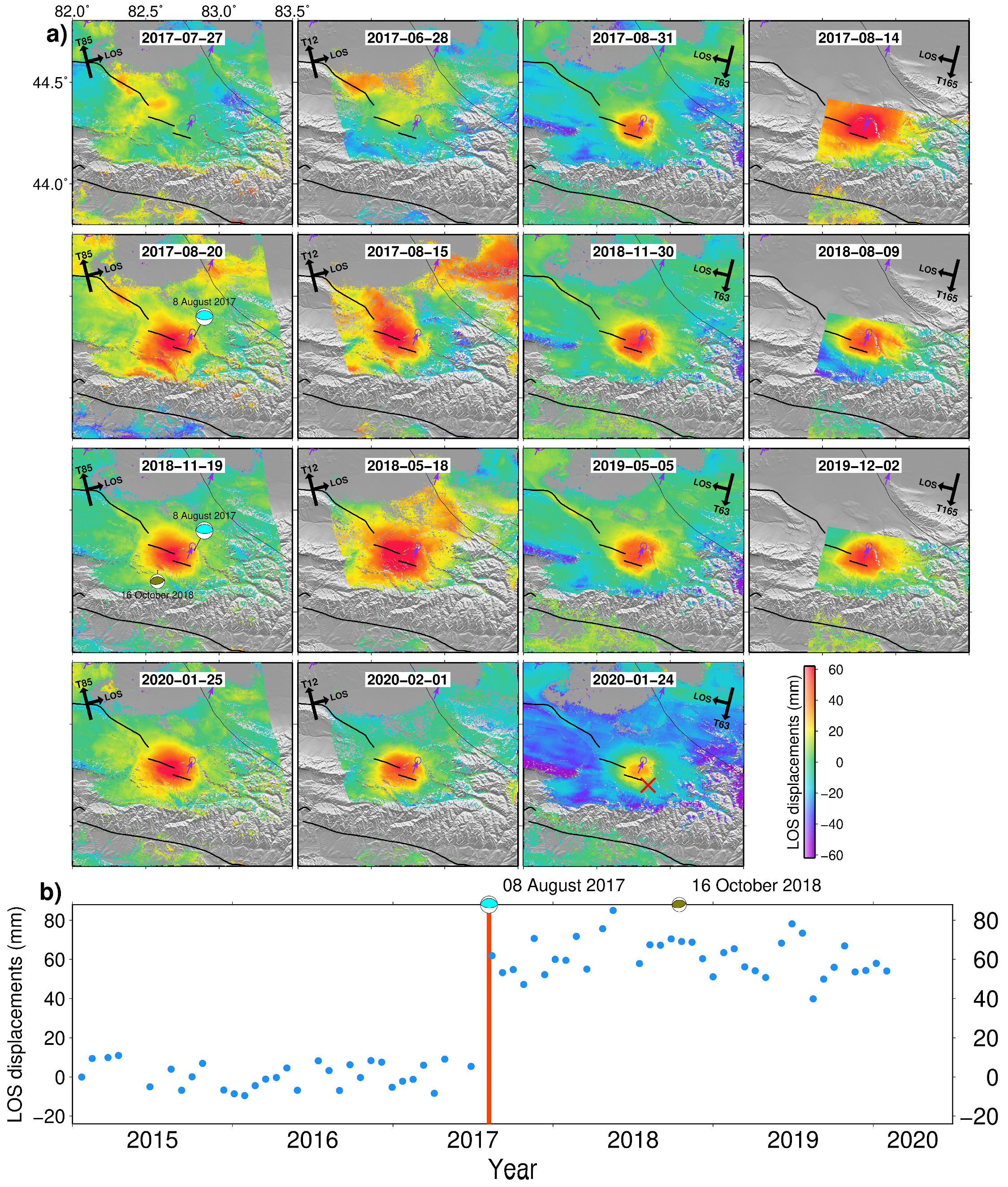
Concerning the Mw 6.3 Jinghe earthquake that struck Xinjiang Province, China, on 8 August 2017, the epicenter was near the eastern section of the Kusongmuxieke Piedmont Fault (KPF) located on the northern Tianshan Mountains. The earthquake was located on the southwestern margin of the Junggar Basin, close to Borohoro Shan, a part of the northern Tianshan Mountain range [8]. The cumulative ground displacement provides the spatiotemporal view of the surface motion from 2017 to 2020, and illustrates the complete time series phases of preseismic, coseismic and post-seismic. Figure 7a shows the time series phases of four tracks T85, T12, T63, and T165. The measured domain surface movement is caused by the Jinghe earthquake in 2017 toward the line-to-sight of the satellite, and the maximum ground displacement reaches over 60 mm. The difference between the incident angles of two adjacent ascending and descending tracks is ~10°, which accounts for the variations in maximum line-of-sight displacement observed in different tracks. The ascending tracks capture more signals compared to the descending tracks.
The deformation field resulting from the Jinghe earthquake exhibits an elliptical shape, which is not typically observed in the displacement field caused by a thrust fault. Normally, the displacement field consists of two sub-fields with opposite directions. However, in the case of Jinghe earthquake, only the deformation field caused by a single side movement pattern prevents us from describing the motion caused by the footwall. Among the four tracks, the southern mountainous area of the epicenter and the agricultural area of Jinghe County contain two significant decorrelation zones, which are caused by the snow cover on mountain peak and the vegetation in the agricultural area. The signals observed by InSAR in these areas are associated with decorrelation artifacts, which can affect the accuracy and reliability of deformation measurements.
It can be observed that the cumulative displacement occurred after earthquake remains at ~60 mm, except for the seasonal fluctuations at the points near the epicenter from Figure 7b. The spatial expansion of the deformation field generated by the earthquake is 18 km in the north–south (NS) direction and 21 km in the east–west (EW) direction. With the continuous shortening of the NS direction of the Tianshan Mountains, the NS fold-and-thrust belt in front of the mountains will extend to the foreland. It is speculated that the Jinghe earthquake may represent a strain relief response to the accumulation of NS shortening. This means that the earthquake released accumulated strain along the fault due to the ongoing tectonic processes in the region. This observation highlights the dynamic nature of the Tianshan Mountains and suggests that seismic events like the Jinghe earthquake play a role in the overall deformation and adjustment of the mountain range in response to tectonic forces.

5.3. Huoerguosi-Manas-Tugulu Anticline Belt

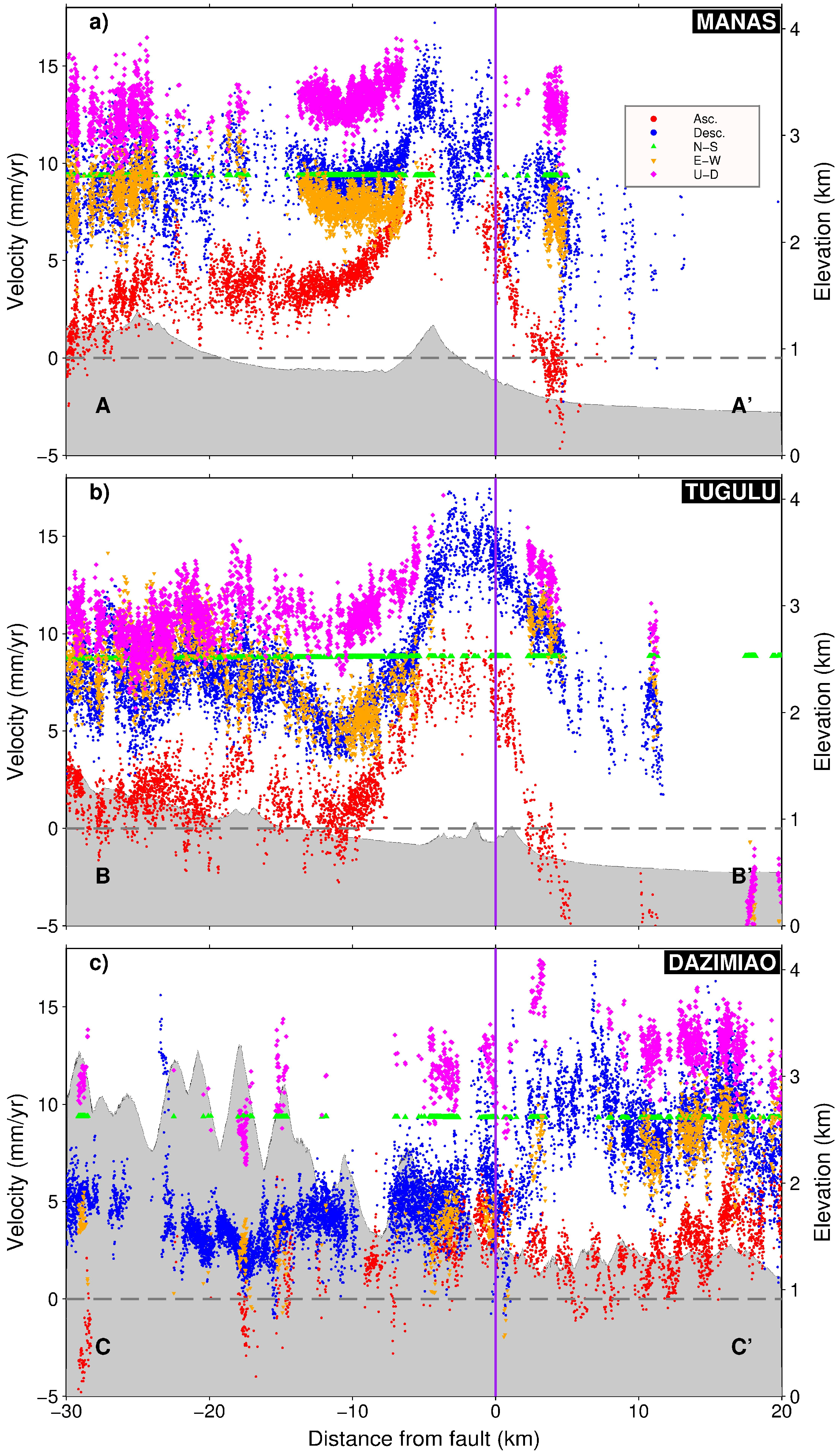
The northern Tianshan structural belt is divided into three segments: the eastern section, the middle and western section, referred to as the Bogda shan section, and the Kuitun section and the Borohoro shan section, respectively (Figure 1b). The Kuitun segment spans approximately 200 km and consists of three fold-and-thrust belts and thrust fault zones. It starts from the west of Urumqi and extends westward toward the vicinity of Kuitun. Within this segment, we have selected three profiles along the Kuitun River and Hutubi River, which are located in close proximity to the Kuitun segment (Figure 8).
The profiles in Figure S5 and Figure 9 show the differences in line-of-sight displacement between ascending and descending tracks, with a noticeable gap between them. The deformation signals captured by the descending track are stronger but also exhibit a higher magnitude of noise. This discrepancy can be attributed to the varying viewing geometries resulting from different angles of incidence. Specifically, profiles across the Manas and Tugulu anticlines reveal peak-to-trough velocities of approximately 10 mm/yr at a distance of ~5 km from the faults. The Dazimiao anticline, on the other hand, exhibits a velocity of around 5 mm/yr. From the analysis of three profiles, it is evident that both the horizontal and vertical velocities exhibit a consistently high level of movement. The north–south convergence remains stable at a rate of 10 mm/yr, with the east–west component being slightly weaker. The vertical component experiences movement at a rate of 12–15 mm/yr and reaches a tough at the fold-and-thrust belt zone. Among these three rows, the Manas anticline exhibits the strongest deformation signal. By examining the relationship between deformation and topography, it becomes evident that the highest part of the Tianshan Mountains is situated adjacent to the active shortening area. This correlation implies that the main uplift in the region is relatively young, likely occurring during the late Cenozoic or Quaternary period. Simultaneously, it can be inferred that the presence of fold-and-thrust belts has caused crustal shortening in the north–south direction, consequently resulting in the vertical thickening and uplift of the crust.
In the northern piedmont of the Tianshan, strong earthquakes are closely associated with ongoing tectonic activity. One notable event is the Mw 6.2 Hutubi earthquake (U.S. Geological Survey) that occurred on 8 December 2016, along the active Huoerguosi-Manas-Tugulu fault in the northern Tianshan belt. This earthquake was characterized as a pure thrust within the northern Tianshan structural belt. The Huoerguosi-Manas-Tugulu anticline belt, which involves the seismogenic fault responsible for the 2016 Hutubi earthquake and the 1906 Manas historical earthquake, plays a significant role in seismic activity in the region [7]. Figure S6 is the rate map in the eastern section of the foreland fold-and-thrust belt of the activity uplifting northern Tianshan obtained from the SBAS-InSAR method. The map clearly illustrates the co-seismic and post-seismic deformation resulting from the Hutubi earthquake. Furthermore, it reveals continuous deformation in the Manas anticline and the Tugulu anticline during the interseismic period. The southern Junggar fault, which hosted the hypocenter of 1906 Mw 7.7 Manas earthquake, displays noticeable surface uplift. Additionally, uplift is observed on the southern side of the seismogenic fault, the Huoerguosi-Manas-Tugulu anticline belt, confirming the intense tectonic activity in this area. These findings emphasize the significance of ongoing tectonic processes and their influence on seismic events and deformation patterns in the northern Tianshan region.

5.4. Kuqa Depression

As seen in LOS deformation maps (Figure 3) and horizontal decomposition rate maps (Figure 4), deformation on the north side of the South Tianshan is distributed across a series of active structures within the mountain ranges and in depression basins. The deformation is primarily concentrated within the superior portions of thrust belts.
The Kuqa Depression, situated in the northern part of the Tarim Basin, is a result of Cenozoic tectonic compressive stress and is considered a regenerated foreland basin. This compressive stress originates from the collision between the Eurasian and Indian plates, leading to the formation of thrust structures and foreland belts within the Kuqa Depression, encompassing extensive Mesozoic and Cenozoic thrust belts [43]. The Kuqa Depression comprises seven structural units, including the Qiulitage thrust belt and the Kelasu structural belt. Qiulitage Depression is located in the southern margin of the Kuqa Depression within the southern Tianshan foreland thrust belt, and a large-scale depression is evident in the Qiulitage thrust belt. Analysis of the east–west displacement map reveals an eastward movement trend on the northern side of the Qiulitage thrust belt, while the southern side exhibits an opposite movement trend. Figure 4 illustrates that the Qiulitage thrust belt is undergoing approximately 1 mm/yr of north–south convergence and 2–3 mm/yr of east–west deformation. Significant subsidence is observed in the Kelasu thrust belt and the Qiulitage thrust belt, which could be attributed to natural gas exploitation activities. Fault-related folds, formed as a result of orogeny, create favorable conditions for regional oil and gas accumulation.
What can be observed is that all the earthquakes with a magnitude of seven or above in the Tianshan block occur in the boundary zone, forming a distinct zone of strong earthquakes. In contrast, only a small number of moderately strong earthquakes occur within the block. The frequency and intensity of earthquakes vary in different areas along the boundary zone. The three-dimensional surface deformation map reveals that the narrow collision zone between the South Tianshan and the Tarim Basin is notably active. There is a predominant north–south convergence in the Tianshan Mountain, with deformation primarily concentrated along certain Cenozoic fold-and-thrust belts. Generally, the western section of the south–north boundary zones experiences stronger earthquakes compared to the eastern section, and the southern boundary zone experiences stronger seismic activity than the northern boundary zone. These observations are valuable for estimating the boundaries of the Tianshan seismic-dangerous area.

6. Conclusions

In this study, we have utilized over 5 years of SAR acquisitions across four ascending and four descending tracks to produce the first InSAR-derived estimate of interseismic slip rate and post-seismic cumulative displacement of recent major faults in Chinese Tianshan. To efficiently handle a substantial volume of SAR data, this study employed a multi-temporal InSAR automatic processing strategy that relied on GACOS. Concurrently, GPS observation data were incorporated into the research to establish a three-dimensional deformation field within the Tianshan region. The final results show that the GACOS-based correction method effectively removed atmospheric delays and allowed for the retrieval of the interseismic deformation field. The focus of the study was on the fold-and-thrust belts along the northern and southern margins of the Tianshan Mountains. The estimated slip rates in the northern fold-and-thrust belt were ~8 mm/yr for the Manas anticline and ~8 mm/yr for the Tugulu anticline. In the southern fold-and-thrust belt, the Kelasu anticline exhibited a slip rate of approximately 5 mm/yr. It was observed that the highest part of the Tianshan is adjacent to active fold-and-thrust belts, indicating that the main uplift in the region is relatively young. The fine, large-scale deformation field obtained in this study provides new insights into the crustal movement and fault deformation mechanisms in the present-day Tianshan area. Overall, the study demonstrates the utility of InSAR and GPS data for understanding the interseismic behavior of major faults in the Tianshan region and contributes to our understanding of the tectonic processes in this area.

Supplementary Materials

The following supporting information can be downloaded at: https://www.mdpi.com/article/10.3390/rs15204901/s1.

Author Contributions

Conceptualization, P.S. Data curation, P.S. and Z.G. Formal analysis, P.S. and X.H. Investigation, P.S. Methodology, X.W. Project administration, X.H. Resources, X.H. Supervision, X.H. Validation, X.H., X.W. and Z.G. Visualization, P.S. and X.W. Writing—original draft, P.S. Writing—review and editing, X.H., X.W. and Z.G. All authors have read and agreed to the published version of the manuscript.

Funding

This work was funded by the Beijing Key Laboratory of Urban Spatial Information Engineering, No. 20220110.

Acknowledgments

We are very grateful for the Sentinel-1A/B data provided by European Space Agency (ESA). GACOS data are supported by NERC through the Centre for the Observation and Modeling of Earthquake Volcanoes and Tectonics (COMET). The figures are produced using Generic Mapping Tools (GMT) software.

Conflicts of Interest

The authors declare no conflict of interest.

References

  1. Wang, M.; Shen, Z.K. Present-Day Crustal Deformation of Continental China Derived From GPS and Its Tectonic Implications. J. Geophys. Res. Solid Earth 2020, 125, e2019JB018774. [Google Scholar] [CrossRef]
  2. Fialko, Y. Interseismic Strain Accumulation and the Earthquake Potential on the Southern San Andreas Fault System. Nature 2006, 441, 968–971. [Google Scholar] [CrossRef] [PubMed]
  3. Wang, H.; Wright, T.J. Satellite Geodetic Imaging Reveals Internal Deformation of Western Tibet. Geophys. Res. Lett. 2012, 39, L07303. [Google Scholar] [CrossRef]
  4. Tong, X.; Sandwell, D.T.; Smith-Konter, B. High-Resolution Interseismic Velocity Data along the San Andreas Fault from GPS and InSAR. J. Geophys. Res. Solid Earth 2013, 118, 369–389. [Google Scholar] [CrossRef]
  5. Hussain, E.; Hooper, A.; Wright, T.J.; Walters, R.J.; Bekaert, D.P.S. Interseismic Strain Accumulation across the Central North Anatolian Fault from Iteratively Unwrapped InSAR Measurements. J. Geophys. Res. Solid Earth 2016, 121, 9000–9019. [Google Scholar] [CrossRef]
  6. Weiss, J.R.; Walters, R.J.; Morishita, Y.; Wright, T.J.; Lazecky, M.; Wang, H.; Hussain, E.; Hooper, A.J.; Elliott, J.R.; Rollins, C.; et al. High-Resolution Surface Velocities and Strain for Anatolia From Sentinel-1 InSAR and GNSS Data. Geophys. Res. Lett. 2020, 47, e2020GL087376. [Google Scholar] [CrossRef]
  7. Lu, R.; He, D.; Xu, X.; Wang, X.; Tan, X.; Wu, X. Seismotectonics of the 2016 M 6.2 Hutubi Earthquake: Implications for the 1906 M 7.7 Manas Earthquake in the Northern Tian Shan Belt, China. Seismol. Res. Lett. 2018, 89, 13–21. [Google Scholar] [CrossRef]
  8. Gong, W.; Zhang, Y.; Li, T.; Wen, S.; Zhao, D.; Hou, L.; Shan, X. Multi-Sensor Geodetic Observations and Modeling of the 2017 Mw 6.3 Jinghe Earthquake. Remote Sens. 2019, 11, 2157. [Google Scholar] [CrossRef]
  9. He, P.; Wen, Y.; Xu, C.; Liu, Y.; Fok, H.S. New Evidence for Active Tectonics at the Boundary of the Kashi Depression, China, from Time Series InSAR Observations. Tectonophysics 2015, 653, 140–148. [Google Scholar] [CrossRef]
  10. Qiao, X.; Yu, P.; Nie, Z.; Li, J.; Wang, X.; Kuzikov, S.I.; Wang, Q.; Yang, S. The Crustal Deformation Revealed by GPS and InSAR in the Northwest Corner of the Tarim Basin, Northwestern China. Pure Appl. Geophys. 2017, 174, 1405–1423. [Google Scholar] [CrossRef]
  11. Jahn, B.-M.; Wu, F.; Chen, B. Granitoids of the Central Asian Orogenic Belt and Continental Growth in the Phanerozoic. Earth Environ. Sci. Trans. R. Soc. Edinb. 2000, 91, 181–193. [Google Scholar]
  12. Wu, J.; Song, X.; Wu, W.; Meng, G.; Ren, Y. Analysis of Crustal Movement and Deformation in Mainland China Based on CMONOC Baseline Time Series. Remote Sens. 2021, 13, 2481. [Google Scholar] [CrossRef]
  13. Liu, D.Q.; Liu, M.; Wang, H.T.; Li, J.; Cheng, J.; Wang, X.Q. Slip Rates and Seismic Moment Deficits on Major Faults in the Tianshan Region. Chin. J. Geophys. 2016, 59, 1647–1660. [Google Scholar]
  14. England, P.; Molnar, P. Late Quaternary to Decadal Velocity Fields in Asia. J. Geophys. Res. Solid Earth 2005, 110, B12401. [Google Scholar] [CrossRef]
  15. Niu, Z.J.; Wang, M.; Sun, H.R.; Sun, J.Z.; You, X.Z.; Gan, W.J.; Xue, G.J.; Hao, J.X.; Xin, S.H.; Wang, Y.Q.; et al. Recent Observations of Current Crustal Movement Velocity Field in Chinese Mainland. Chin. Sci. Bull. 2005, 50, 839–840. [Google Scholar] [CrossRef]
  16. Yang, Z.X.; Waldhauser, F.; Chen, Y.T.; Richards, P.G. Double-Difference Relocation of Earthquakes in Central-Western China, 1992–1999. J. Seismol. 2005, 9, 241–264. [Google Scholar] [CrossRef]
  17. Wang, H.; Liu, M.; Cao, J.; Shen, X.; Zhang, G. Slip Rates and Seismic Moment Deficits on Major Active Faults in Mainland China. J. Geophys. Res. Solid Earth 2011, 116, B02405. [Google Scholar] [CrossRef]
  18. Campbell, G.E.; Walker, R.T.; Abdrakhmatov, K.; Schwenninger, J.; Jackson, J.; Elliott, J.R.; Copley, A. The Dzhungarian Fault: Late Quaternary Tectonics and Slip Rate of a Major Right-Lateral Strike-Slip Fault in the Northern Tien Shan Region. J. Geophys. Res. Solid Earth 2013, 118, 5681–5698. [Google Scholar] [CrossRef]
  19. Wu, C.; Wu, G.; Shen, J.; Chen, J.; Chang, X. The Late-Quaternary Activity of the Nalati Fault and Its Implication for the Crustal Deformation in the Interior of the Tianshan Mountains. Quat. Sci. 2014, 34, 269–280. [Google Scholar]
  20. Li, Y.; Liu, M.; Hao, M.; Zhu, L.; Cui, D.; Wang, Q. Active Crustal Deformation in the Tian Shan Region, Central Asia. Tectonophysics 2021, 811, 228868. [Google Scholar] [CrossRef]
  21. Burchfiel, B.C.; Brown, E.T.; Qidong, D.; Xianyue, F.; Jun, L.; Molnar, P.; Jianbang, S.; Zhangming, W.; Huichuan, Y. Crustal Shortening on the Margins of the Tien Shan, Xinjiang, China. Int. Geol. Rev. 1999, 41, 665–700. [Google Scholar] [CrossRef]
  22. Rodriguez, E.; Martin, J.M. Theory and Design of Interferometric Synthetic Aperture Radars. IEE Proc. F (Radar Signal Process.) 1992, 139, 147–159. [Google Scholar] [CrossRef]
  23. Werner, C.; Wegmüller, U.; Strozzi, T.; Wiesmann, A. GAMMA SAR and Interferometric Processing Software. In Proceedings of the ERS—ENVISAT Symposium, Gothenburg, Sweden, 16–20 October 2000. [Google Scholar]
  24. Wegnüller, U.; Werner, C.; Strozzi, T.; Wiesmann, A.; Frey, O.; Santoro, M. Sentinel-1 Support in the GAMMA Software. Procedia Comput. Sci. 2016, 100, 1305–1312. [Google Scholar] [CrossRef]
  25. Farr, T.G.; Rosen, P.A.; Caro, E.; Crippen, R.; Duren, R.; Hensley, S.; Kobrick, M.; Paller, M.; Rodriguez, E.; Roth, L.; et al. The Shuttle Radar Topography Mission. Rev. Geophys. 2007, 45, RG2004. [Google Scholar] [CrossRef]
  26. Lin, G.; Shearer, P.; Fialko, Y. Obtaining Absolute Locations for Quarry Seismicity Using Remote Sensing Data. Bull. Seismol. Soc. Am. 2006, 96, 722–728. [Google Scholar] [CrossRef]
  27. Jin, Z.; Fialko, Y. Coseismic and Early Postseismic Deformation Due to the 2021 M7.4 Maduo (China) Earthquake. Geophys. Res. Lett. 2021, 48, e2021GL095213. [Google Scholar] [CrossRef]
  28. De Zan, F.; Guarnieri, A.M. TOPSAR: Terrain Observation by Progressive Scans. IEEE Trans. Geosci. Remote Sens. 2006, 44, 2352–2360. [Google Scholar] [CrossRef]
  29. Werner, C.L.; Wegmüller, U.; Strozzi, T. Processing Strategies for Phase Unwrapping for InSAR Applications. In Proceedings of the European Conference on Synthetic Aperture Radar (EUSAR 2002), Cologne, Germany, 4–6 June 2002. [Google Scholar]
  30. Pepe, A.; Lanari, R. On the Extension of the Minimum Cost Flow Algorithm for Phase Unwrapping of Multitemporal Differential SAR Interferograms. IEEE Trans. Geosci. Remote Sens. 2006, 44, 2374–2383. [Google Scholar] [CrossRef]
  31. Biggs, J.; Wright, T.; Lu, Z.; Parsons, B. Multi-Interferogram Method for Measuring Interseismic Deformation: Denali Fault, Alaska. Geophys. J. Int. 2007, 170, 1165–1179. [Google Scholar] [CrossRef]
  32. Watson, A.R.; Elliott, J.R.; Walters, R.J. Interseismic Strain Accumulation Across the Main Recent Fault, SW Iran, From Sentinel-1 InSAR Observations. J. Geophys. Res. Solid Earth 2022, 127, e2021JB022674. [Google Scholar] [CrossRef]
  33. Zebker, H.A.; Rosen, P.A.; Hensley, S. Atmospheric Effects in Interferometric Synthetic Aperture Radar Surface Deformation and Topographic Maps. J. Geophys. Res. Solid Earth 1997, 102, 7547–7563. [Google Scholar] [CrossRef]
  34. Yu, C.; Penna, N.T.; Li, Z. Generation of Real-Time Mode High-Resolution Water Vapor Fields from GPS Observations. J. Geophys. Res. 2017, 122, 2008–2025. [Google Scholar] [CrossRef]
  35. Yu, C.; Li, Z.; Penna, N.T. Interferometric Synthetic Aperture Radar Atmospheric Correction Using a GPS-Based Iterative Tropospheric Decomposition Model. Remote Sens. Environ. 2018, 204, 109–121. [Google Scholar] [CrossRef]
  36. Yu, C.; Li, Z.; Penna, N.T.; Crippa, P. Generic Atmospheric Correction Model for Interferometric Synthetic Aperture Radar Observations. J. Geophys. Res. Solid Earth 2018, 123, 9202–9222. [Google Scholar] [CrossRef]
  37. Song, X.; Jiang, Y.; Shan, X.; Gong, W.; Qu, C. A Fine Velocity and Strain Rate Field of Present-Day Crustal Motion of the Northeastern Tibetan Plateau Inverted Jointly by InSAR and GPS. Remote Sens. 2019, 11, 435. [Google Scholar] [CrossRef]
  38. Zhao, D.; Qu, C.; Shan, X.; Bürgmann, R.; Gong, W.; Zhang, G. Spatiotemporal Evolution of Postseismic Deformation Following the 2001 Mw7.8 Kokoxili, China, Earthquake from 7 Years of Insar Observations. Remote Sens. 2018, 10, 1988. [Google Scholar] [CrossRef]
  39. Berardino, P.; Fornaro, G.; Lanari, R.; Sansosti, E. A New Algorithm for Surface Deformation Monitoring Based on Small Baseline Differential SAR Interferograms. IEEE Trans. Geosci. Remote Sens. 2002, 40, 2375–2383. [Google Scholar] [CrossRef]
  40. Wang, Y.; Feng, G.; Li, Z.; Xu, W.; Wang, H.; Hu, J.; Liu, S.; He, L. Estimating the Long-Term Deformation and Permanent Loss of Aquifer in the Southern Junggar Basin, China, Using InSAR. J. Hydrol. 2022, 614, 128604. [Google Scholar] [CrossRef]
  41. Shen, J.; Wang, Y.; Li, Y.; Jiang, H.; Xiang, Z. Late Quaternary Right-Lateral Strike-Slip Faulting along the Bolokenu-Aqikekuduke Fault in Chinese Tian Shan. Seismol. Geol. 2003, 25, 183–194. [Google Scholar]
  42. Ammon, C.J. Source Parameters of Moderate-Sized Earthquakes in the Tien Shan, Central Asia from Regional Moment Tensor Inversion. Geophys. Res. Lett. 1998, 25, 3181–3184. [Google Scholar]
  43. Guangjie, Z.; Xianqing, L.; Mancang, L.; Caiyuan, D.; Jin, L.; Yang, L.; Zhongyao, X. Fault activity in the northern structural belt of Kuqa Depression and its significance for oil and gas accumulation. J. Min. Sci. Technol. 2022, 7, 618. [Google Scholar]
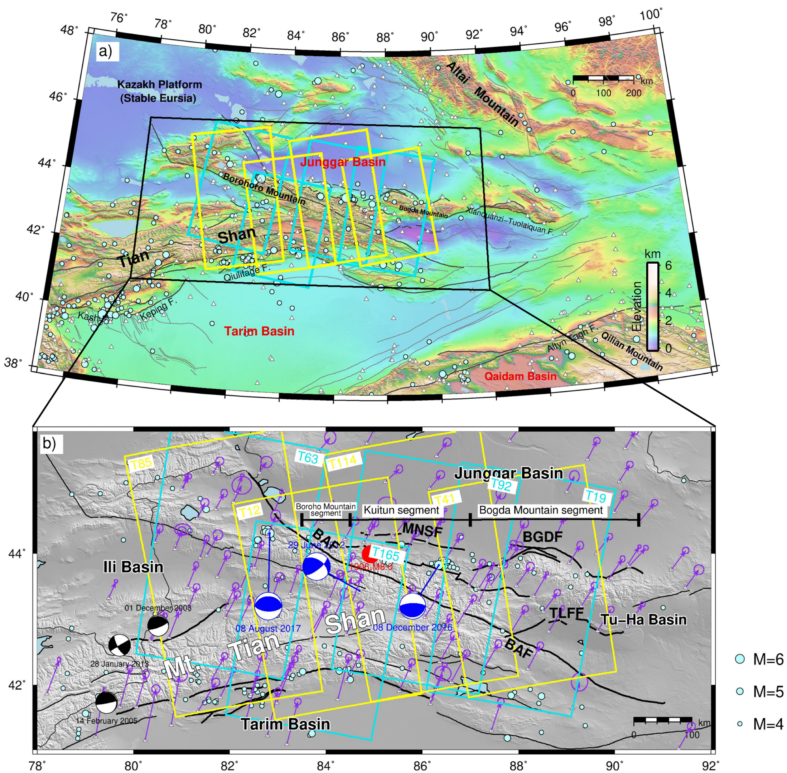
Figure 1. (a) General geological map of the Chinese Tianshan and surrounding areas of central Asia. Topographic relief, showing major active faults (black solid lines) and historical earthquake epicenters. Cyan dots indicate the seismicity (M > 4) between 2015 and 2020 from USGS. The white triangles represent the GPS stations operated by the Crustal Motion Observation Network of China. (b) Yellow and cyan rectangles refer to the coverage of four ascending and descending Sentinel-1 A/B tracks, respectively, with track numbers indicated.
Remotesensing 15 04901 g001
Figure 2. Perpendicular and temporal baseline plot showing the network of interferograms on four ascending and four descending Sentinel-1 tracks used in this study. The blue circles represent SAR acquisitions, the orange stars mark the reference images, and yellow circles are the dropped acquisitions on each track. The gray lines present the interferometric pairs on each track; yellow lines are the dropped interferograms.
Remotesensing 15 04901 g002
Figure 3. Collage of interseismic line-of-sight rate maps (2015–2020) on four ascending tracks (a) and four descending tracks (b). Comparison of interseismic InSAR line-of-sight velocity at ~86°E and GPS observations projected along the across-fault profile. Negative (red) and positive (blue) values indicate relative ground motion toward and away from the satellite. Cyan squares in (c,d) are error bars with 2-sigma within 10 km of the fault crossing profiles on ascending tracks. Magenta squares are LOS-converted 2D GPS velocities from Wang et al. (2020). (e,f) Same as (c,d) but for the descending tracks.
Remotesensing 15 04901 g003
Figure 4. (a) East–west component decomposition of the InSAR mean velocity map. (b) The interpolated north–south velocities based on the GPS velocities using the data from Wang et al. (2020). (c) The vertical component of the InSAR velocity map. The red lines denote the BAF fault.
Remotesensing 15 04901 g004
Figure 5. (a) Average fault-parallel velocity map combining ascending and descending tracks in the overlapping area. The lines labeled A-A’ and B-B’ are profiles through the fault-parallel velocity, (b,c) fault-parallel interseismic velocity profiles across BAF from InSAR. The black points are fault-parallel velocities projected from within ±10 km distance onto the profile; the purple solid line is the best fit.
Remotesensing 15 04901 g005
Figure 6. One-dimensional (the diagonal panel in each subplot) and two-dimensional (the panel with contour lines) marginal probability distributions using screw dislocation model for velocity profiles AA’, BB’ from Markov chain Monte Carlo (MCMC) analysis using InSAR data.
Remotesensing 15 04901 g006aRemotesensing 15 04901 g006b
Figure 7. (a) Selected cumulative time series displacements from four tracks covering the Jinghe earthquake epicenter, track 85 (the first row), 12 (the second row), 63 (the third row), and 165 (the fourth row), with their different spatial coverage and LOS angles. The red mark is the selected point. Focal mechanisms of two Mw > 5.2 events are also shown. (b) Time series displacements from 2015 to 2020 for five by five averaged pixel areas and marked by crosses in (a).
Remotesensing 15 04901 g007
Figure 8. (ac) are the E-W, N-S, and U-D velocity maps, respectively, covering the Kuitun segment fold-and-thrust belts.
Remotesensing 15 04901 g008
Figure 9. (ac) are the profiles across the Kuitun segment fold-and-thrust belt that refer to the figure above, respectively.
Remotesensing 15 04901 g009
Disclaimer/Publisher’s Note: The statements, opinions and data contained in all publications are solely those of the individual author(s) and contributor(s) and not of MDPI and/or the editor(s). MDPI and/or the editor(s) disclaim responsibility for any injury to people or property resulting from any ideas, methods, instructions or products referred to in the content.