Review

Satellite Remote Sensing and Non-Destructive Testing Methods for Transport Infrastructure Monitoring: Advances, Challenges and Perspectives

by
Valerio Gagliardi
1,*,
Fabio Tosti
2,3,
Luca Bianchini Ciampoli
1,
Maria Libera Battagliere
4,
Luigi D’Amato
4,
Amir M. Alani
5 and
Andrea Benedetto
1
1
Department of Engineering, Roma Tre University, Via Vito Volterra 62, 00146 Rome, Italy
2
School of Computing and Engineering, University of West London (UWL), St Mary’s Road, Ealing, London W5 5RF, UK
3
The Faringdon Research Centre for Non-Destructive Testing and Remote Sensing, University of West London (UWL), St Mary’s Road, Ealing, London W5 5RF, UK
4
Italian Space Agency (ASI), Via del Politecnico, 00133 Rome, Italy
5
Faculty of Engineering, Computing and the Environment, Kingston University London, Penrhyn Road Campus, Penrhyn Road, London KT1 2EE, UK
*
Author to whom correspondence should be addressed.
Remote Sens. 2023, 15(2), 418; https://doi.org/10.3390/rs15020418
Submission received: 23 November 2022 / Revised: 31 December 2022 / Accepted: 3 January 2023 / Published: 10 January 2023
(This article belongs to the Special Issue Remote Sensing in Civil and Environmental Engineering)

Abstract

:
High-temporal-frequency monitoring of transport infrastructure is crucial to facilitate maintenance and prevent major service disruption or structural failures. Ground-based non-destructive testing (NDT) methods have been successfully applied for decades, reaching very high standards for data quality and accuracy. However, routine campaigns and long inspection times are required for data collection and their implementation into reliable infrastructure management systems (IMSs). On the other hand, satellite remote sensing techniques, such as the Multi-Temporal Interferometric Synthetic Aperture Radar (MT-InSAR) method, have proven effective in monitoring ground displacements of transport infrastructure (roads, railways and airfields) with a much higher temporal frequency of investigation and the capability to cover wider areas. Nevertheless, the integration of information from (i) satellite remote sensing and (ii) ground-based NDT methods is a subject that is still to be fully explored in civil engineering. This paper aims to review significant stand-alone and combined applications in these two areas of endeavour for transport infrastructure monitoring. The recent advances, main challenges and future perspectives arising from their mutual integration are also discussed.

1. Introduction

Implementing effective maintenance of transport infrastructure assets is a crucial task, as it involves important macro-economic and safety implications. The development of maintenance approaches based on the critical condition of infrastructure has triggered new demand for the use of non-destructive testing (NDT) methods in their assessment and health monitoring. Continuous monitoring of transport structures, including roads, railways and bridges, is a priority for asset owners and administrators. This ensures structural stability and operational safety, and prevents damage and deterioration, leading to expensive rehabilitation, failures and collapses [1]. Conventional technologies and methods for on-site infrastructure monitoring have been successfully applied in the past. Several ground-based NDT technologies and sensors are currently available for subsidence monitoring and displacement mapping. Amongst others, accelerometers [2], strain gauges [3], global positioning systems (GPS) [4], levelling [5], ground penetrating radar (GPR) [6,7,8], laser scanners [9,10], infrared thermography (IRT) [11] and terrestrial SAR interferometry [12] have been used in the sector.
However, the costs of the equipment are substantial, and the on-site survey operations can be demanding and difficult to implement, with a high temporal frequency at the network level. This is above all due to economic and administrative budget constraints [13]. To tackle these limitations, several advanced satellite-based remote sensing techniques, i.e., the persistent scatterers interferometry (PSI) methods, amongst which are the Permanent (or Persistent) Scatterers Interferometry (PS-InSAR) [14,15] and the Small BAseline Subset (SBAS) [16], have gained momentum in the last few years for the monitoring of transport assets and the investigation of the surrounding environment. Several successful applications have proven the viability of using satellite-based remote sensing techniques in this sector, paving the way for the development of further research and applications [13]. In addition, the wide land coverage and the ability to collect data with a high temporal frequency have contributed to the promotion of the use of this technology in combination with other monitoring techniques. The concept of data integration of the information collected by non-destructive testing and satellite-based techniques with different spatial and temporal resolutions stands as a future challenge in research [13,17,18]. New investigations have recently emerged with the aim of defining novel algorithms, methods and surveying procedures for the integration of multi-source, multi-resolution and multi-temporal information. A major advantage of this approach is in the provision of additional information that is not available when technologies are used individually [17,18,19]. This paper is organised as follows: an introduction is given in Section 1, followed by an overview of significant stand-alone applications of satellite remote sensing and ground-based NDT methods for infrastructure monitoring (Section 2). Section 3 reports an overview of the main maintenance strategies and monitoring procedures for transport assets, followed by Section 4, describing the aim and objectives of this paper. Section 5 reports an overview of PSI applications for infrastructure monitoring. Section 6 presents recent studies on the combined application and data integration between ground-based and PSI methods in the monitoring of transport structures. Advances, benefits and main challenges for network-level monitoring with satellite remote sensing are reported in Section 7. Conclusions, challenges and future perspectives are discussed in Section 8.

2. Stand-Alone Ground-Based Technology Applications in Transport Infrastructure Monitoring

The occurrence of dramatic events due to the vulnerability of transport infrastructure to natural hazards (e.g., earthquakes, subsidence and landslides) and endogenous events (e.g., the end of pavement service life, raising traffic volumes, the ageing of materials, corrosion of rebars in reinforced concrete structures) have emphasised the importance of routine monitoring and the provision of effective maintenance plans at the international level. Countries with transportation network systems highly exposed to major natural hazards are proactively investing money to promote more effective asset-management programs. This is the case in Italy, where the Ministry for Transport and Infrastructure has urged the implementation of new measures to achieve continuous infrastructure monitoring though the provision of dedicated guidelines [20]. In this framework, monitoring the structural integrity of transport infrastructure is a priority for national authorities and asset administrators to guarantee the structural integrity and the operational safety. This aims to prevent infrastructure damage and deterioration prior to the occurrence of any expensive rehabilitation or structural failure. In the last decade, several sensors and technologies, such as accelerometers, the Internet of Things (IOT) sensors, wireless network systems and ground-based NDTs, e.g., ground-penetrating radar (GPR) and light detection and ranging (LiDAR), have proven effective for the provision of dense arrays of data and their incorporation into more comprehensive asset management systems, as reported in Table 1.
The main limitations of the stand-alone use of these technologies in infrastructure monitoring include the difficulty of implementing routine inspections for multi-temporal data acquisition, a relatively limited land coverage and physics constraints from the technologies’ working principles that limit the data spatial resolution. A limited repeatability of measurements in time and the high costs of non-destructive inspections for implementation at the network level stand as additional constraints. To overcome these limitations, satellite-based remote sensing technologies have been increasingly used in the last few years. Advantages include the provision of higher temporal revisiting time and spatial resolution of measurements, and the possibility of creating archives from the historical time-series of the displacements [13,18,34,35].
Amongst the most important limitations of the InSAR techniques, we can mention:
(i)
the necessity of collecting datasets with different orbit geometries for the calculation of the vertical and horizontal components of the displacements, using ground-truth reference points;
(ii)
the high computational requirements for the processing of SAR imagery at the network level, especially in case of long-term investigations and high-frequency datasets (i.e., X-Band).
Compared to high-resolution datasets, medium-resolution datasets (i.e., acquired in C-Band) stand as more easily accessible information by end-users for large-scale analyses and the measurements of settlements at the centimetre scale. Use of the medium-resolution imagery allows for lighter data processing and management flows, and it permits to investigate wider areas and sections of the transportation network.
Nevertheless, several limitations still exist on the use of SAR medium-resolution data for transport infrastructure monitoring, including:
(i)
the ground pixel resolution, which does not allow the allocation of PS displacements from a randomly given object to its actual position on the ground;
(ii)
the accuracy of the measurements, due to the relatively limited frequency range of the sensors.
Under specific limiting conditions, associating the PS data to the actual structural element can be challenging. This occurs especially in urban areas with buildings located in the vicinity of transport infrastructure, where errors can be introduced for the data interpretation stage. Within this framework, the use of satellite remote sensing for the systematic monitoring of transportation assets, as well as its accuracy against other conventional ground-based methods, has been widely discussed for the past 15 years.
To illustrate the development of MT-InSAR techniques for transport infrastructure monitoring, relevant literature has been here reviewed using the “Scopus” scientific database. Overall, 280 research works have been identified including journal (research) papers, review papers, conference proceedings and book chapters from 2000 to 2022, as represented in Figure 1. The first step of the procedure was based on the selection of the most relevant keywords used for research in SAR applications for infrastructure monitoring. For the SAR applications, several keywords were selected and implemented for research from the Scopus database [36], including: “InSAR”, OR “MT-InSAR”, (multi-temporal InSAR), OR “DInSAR”, (differential InSAR), OR “A-DInSAR”, (advanced DInSAR), OR “PS” (persistent scatterers), and “PSI” (persistent scatterers interferometry). The second step consists in the inclusion of the keywords “monitoring” AND “infrastructure”, and the selection of four infrastructure classes historically identified as conventional areas of investigation for PSI applications: “bridges” OR “railways” OR “highways” OR “runways”. The review includes the research of the selected keywords in the “article title, keywords and abstract” for each paper, available in the Scopus database.
The trend in Figure 1a is exponential, indicating that the infrastructure monitoring area has been attracting the attention of researchers in the past two decades. Two leaps can be observed that occurred in 2010 and 2020, respectively. The first was most likely related to the year of the launching of new-generation satellite missions, which included the Italian Constellation of Small Satellites for Mediterranean Basin Observation (COSMO-SkyMed) satellites, between 2007 and 2010, and the TerraSAR-X (TSX) in 2007, with high spatial and temporal resolution. The second leap is likely related to the launch of the Sentinel-1 (S1) mission in 2014, as part of the Copernicus Programme of the European Space Agency (ESA), with regular and revisit times of 12 days. These advances increase the density of PSs extracted by high-resolution SAR data up to 6 times, as opposed to those expected by medium-resolution SAR, e.g., RADARSAT-1 and Envisat. Accordingly, the combination of high spatial density, wide coverage and high sensitivity to small deformations has allowed analysis of the deformations of individual structural elements at the network level. This significantly increases the potential of MT-InSAR techniques in infrastructure monitoring.
The cumulative number of citations for the selected papers were collected for 15 years (from 2006 to 2022), as reported in Figure 2. A significant interest of researchers in the implementation of satellite-based techniques for infrastructure monitoring is proven by the increase in the yearly cumulative citations, amounting to approximately 200 citations in 2017 and more than 900 in 2021.

3. Maintenance Strategies and Monitoring Procedures for Transport Structures

Recent dramatic events occurring on the European transport network have pointed out that a more detailed network-level assessment of the transport asset condition is urgently required [37,38]. Similar consideration could be given to the high exposure and vulnerability of the transport system to major natural events, such as floods or earthquakes [37,38,39]. It is worth mentioning that most of the highway and railway assets were constructed between the 1960s and the 1980s, hence their nominal service life of typically 25–40 years has already elapsed. This highlights the importance of providing a successful asset maintenance strategy. Effective planning of maintenance protects the infrastructure serviceability over time by decreasing the risk of collapse during ordinary operations (e.g., the Morandi Bridge in Genoa, Italy [39,40] or the Majerhat Bridge in Kolkata, India [41]) or critical natural hazard events (e.g., Troja footbridge in Prague [42], Czech Republic [43] or Pfeifer Canyon Bridge, California, US [44]). On the other hand, only limited attention is paid towards the management of the existing assets, with potentially dramatic macroeconomic consequences [45].
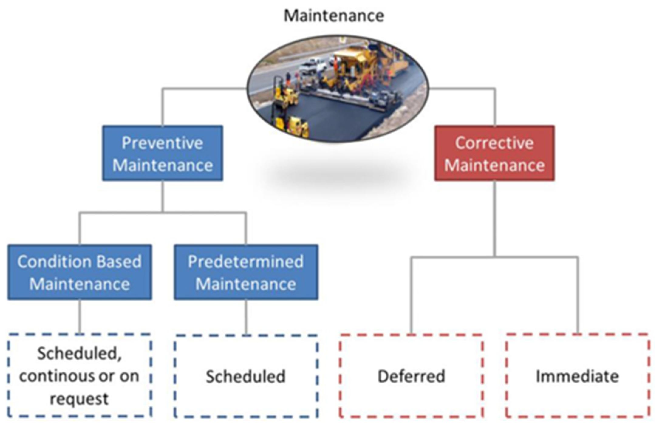
Maintenance activities are traditionally organised based on different types of approaches. The main aim of these activities is the definition of an ideal time, localisation and modality (i.e., defining “When, Where and How”) of inspection surveys on the infrastructure network [46]. A classification of maintenance types and their mutual relationship is indicated in the standards “EN 13306, 2001” [47], as shown in Figure 3:
Accordingly, maintenance activities can be traditionally sorted in two main approaches, namely “corrective” (or “prescriptive”) and “preventive” maintenance.
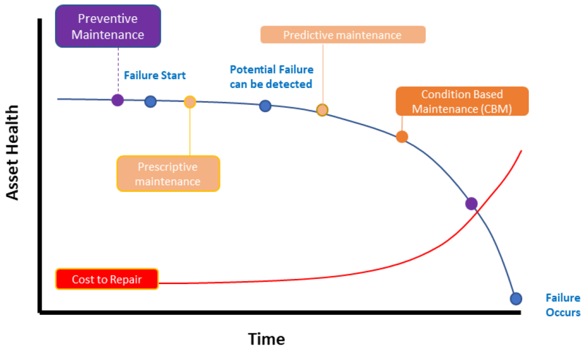
  • Corrective maintenance is implemented when breakdowns or evident failures occur on the network [48]. Corrective maintenance can be also performed with the system continuing to operate. Nevertheless, corrective maintenance can be extremely expensive, as costs of repairing are not linearly proportional to the scale and extent of the failure.
  • Preventive maintenance must be put in place before a fault surfaces, and it is scheduled according to fixed time intervals. This prevents any possible break-down and failure. A preservation approach towards the infrastructure asset maintenance is strongly recommended by experts, and to date, largely used by most of the asset owners. Preventive maintenance can be sorted into two sub-classes [49]:
    -
    Predetermined maintenance: interventions are scheduled on a time-based criterion (e.g., road resurfacing for a fixed amount of time), without the need to investigate the infrastructure condition. This maintenance model is scheduled a priori and performed according to convenient time schedules to contain budget costs. It does not rely on the actual condition of the asset, and the time intervals for the implementation of the maintenance are established based on prediction models. It is to be noted that if the infrastructure does not require maintenance and this approach is followed, time intervals scheduled for maintenance that are too close together can result in economic losses [50].
    -
    Condition-based maintenance (CBM): According to SS-EN 13306 (2001) [47], this strategy is implemented by forecasting the decay trend of relevant infrastructure performance parameters, taken as the reference. Interventions are planned based on the actual need for maintenance, which is ascertained on site. Condition-based maintenance is based on gathering information about the actual and predicted element condition retrieved from scheduled, continuous or on-demand inspections of the infrastructure. CBM is an appropriate strategy for structural elements where the formation of decay can affect the operations, structural health or material properties, or it can have an impact on the surrounding environment. In contrast to the predetermined maintenance, this approach is suitable for issues with a random probability of failure or damage occurrence. On one hand, the CBM maintenance strategy is the most popular strategy amongst researchers [51,52]. On the other hand, it requires a comprehensive survey plan to facilitate up-to-date knowledge of the asset condition. An example of the corrective, preventive, predetermined and CBM approaches is reported in Figure 4. Research has demonstrated that the CBM approach is the most suitable for infrastructure monitoring, as it minimises budget economic losses and the risk of implementing ineffective interventions.
Conventional inspection methods for road infrastructure maintenance rely on the use of destructive techniques, such as coring, drilling or otherwise removing part of the structure to allow inner visual inspections (e.g., bridge deck inspections), or material performance checks in the laboratory environment. Despite the high reliability of these methods, they are costly and time-consuming. In addition, the outcomes have limited significance since they only represent local conditions of the infrastructure and cannot be projected to represent longer distances. These factors have huge impacts on the effectiveness of maintenance as well as on the costs and time of the decision-making process. To overcome the above limitations, several NDT methods, and more recently, satellite-based remote sensing technologies, have been introduced [13,53,54]. As the budget for road infrastructure maintenance is carefully managed to limit wrong allocations of funds, road authorities must increase the efficiency of measures and reduce the overall costs. This can be achieved by utilising new procedures and technologies, and it can benefit the sustainability of new projects and the implementation of maintenance on existing roads [55,56]. Since maintenance costs usually cover most of the annual budget on road infrastructure, asset owners are continuously striving to develop more efficient and cost-effective methodologies. Several strategies and contract forms have been implemented to date, such as maintenance outsourcing in competitive markets, as well as the development of life-cycle cost models, new funding and subsidiary forms [57].
The cost of a road structure over its service life is a function of design, quality of the construction, the maintenance strategies and the monitoring operations. Accordingly, an optimal asset management system requires the definition of life-cycle cost estimations for all the above-mentioned components, as well as the assessment of early-stage decays. In the last wo decades, the use of NDTs, such as acoustic [58,59], electromagnetic [60,61,62,63,64] and thermographic methods [65], has gained momentum for health monitoring of civil engineering infrastructures. These methods, although very effective, can provide information with gaps dictated by their own physics and working principles. As an example, LiDAR systems can provide high-density level of images and cloud-points for the inspected objects [66], but they cannot collect any information that is not visible on the surface.
Therefore, the integration of datasets collected with different NDTs stands as a viable approach to fill technology-specific gaps and assure a more comprehensive assessment of the infrastructure [67]. In the last decade, satellite-based remote sensing techniques have proven to be faster and more cost effective for this purpose, thereby paving the way towards the implementation of a quasi-continuous and updated infrastructure information system at the network level.

4. Aim and Objectives

The main aim of this work is to review current research on the application of advanced monitoring procedures based on the integration between ground-based non-destructive testing (GB-NDT) methods and satellite-based MT-InSAR techniques, for transport infrastructure monitoring.
To achieve the above aim, the main objectives are as follows:
  • to identify significant and recent applications in the field and analyse the suitability of medium- and high-resolution SAR data through the satellite-based PSI monitoring technique;
  • to identify relevant studies based on the integration of data obtained by the PSI technique with data collected using GB-NDTs, aimed at improving upon the interpretation phase.

5. Satellite Remote Sensing Techniques for Infrastructure Monitoring

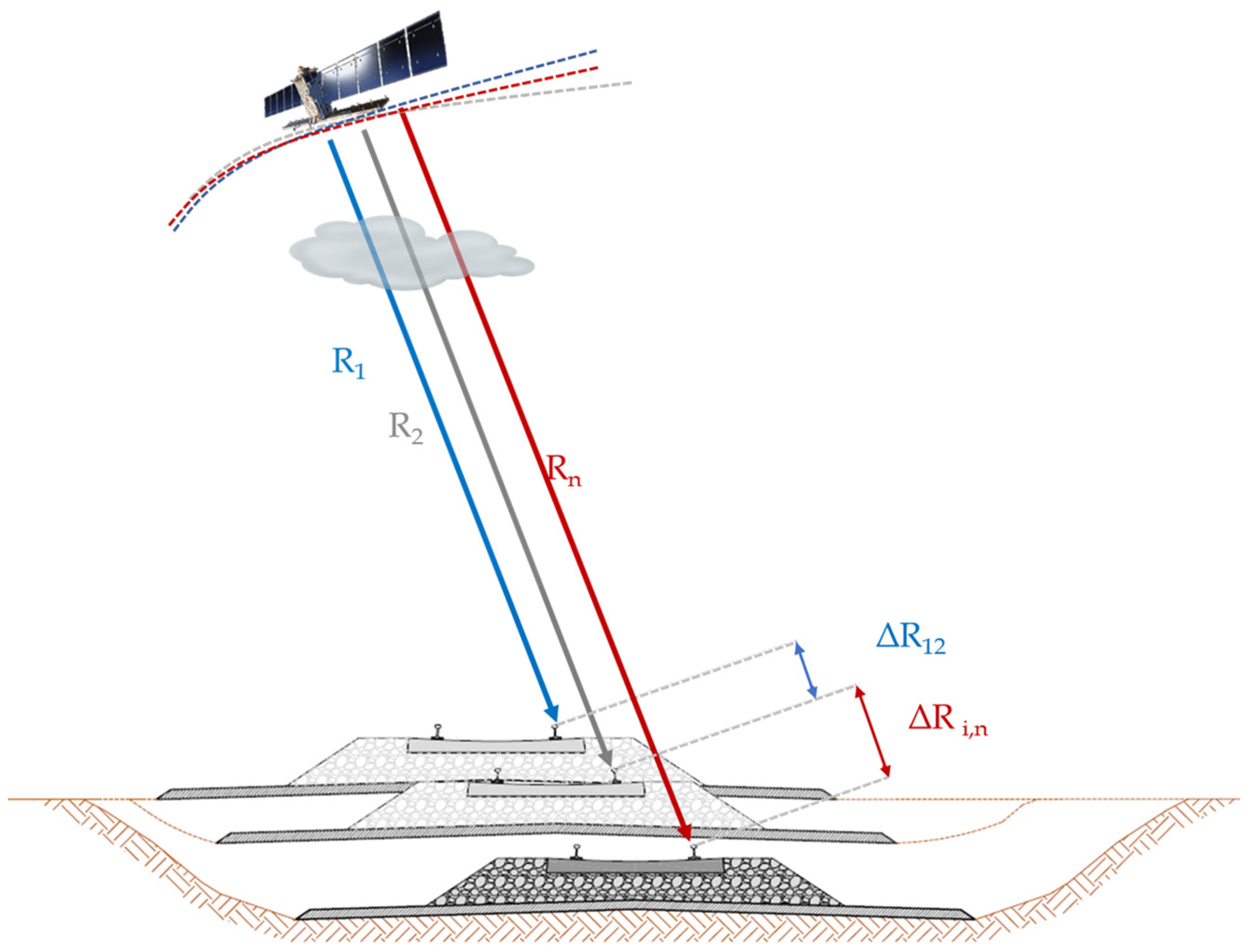
Use of InSAR techniques allows the detection of displacements along the line of sight (LoS) (i.e., the observation direction) of the SAR sensor, and it consists in the measurement of the signal phase variation between images acquired on the same sections at different times. When a vertical displacement occurs on the ground, the distance between the sensor and the ground varies, affecting the phase of the signal back-received by the sensor (Figure 5).
An interferogram can be therefore generated from the phase difference between two SAR images, returning a matrix of numerical values comprised in the interval (−π ÷ π) and representing the surface movements. Thus, from the analysis of an interferogram, it is possible to recognise the scale of displacements on the area during the observation time. The two SAR images are named the master image and the slave image, respectively. The slave image must be co-registered and resampled with reference to the geometry of the master image. The interferometric phase is subsequently derived from a pixel-by-pixel multiplication with the conjugate complex of each pixel, in the master and slave image, yielding a value reported in Equation (1):
Φ w [ π , π ]   [ r a d ]
where Φ w is the “wrapped” value of the interferometric phase.
The phase ϕ is the key information in any interferometric application, as it relates to different phase components, as follows:
ϕ = ϕflat + ϕtopo + ϕdef + ϕatm + ϕnoise
where ϕflat, ϕtopo, ϕdef, ϕatm and ϕnoise are the phase components for the reference surface, topography, deformations, atmospheric delay and noise, respectively. Displacements are detected by relating the signal phase variation between progressive acquisitions to the motion of the target under investigation (Figure 4). In detail, the general method consists in the comparison of a dataset of N SAR images, collected at different times on the same area of interest (AoI), and by calculating the interferometric phase ∆ϕ for each N-1 pair, as referred to the master image. The component related to the ground deformations ϕdef must be calculated from Equation (2), which is proportional to the sensor-to-target distance difference (∆r) divided by the wavelength (λ) of the SAR sensor, as expressed by Equation (3):
Δ ϕ d e f = 4 π   λ   Δ r  
Multi-temporal InSAR (MT-InSAR) techniques were developed as an evolution of the DIfferential SAR Interferometry (DInSAR). Several techniques have been developed since, including persistent scatterers interferometry (PSI) and the permanent scatterers (PS-InSAR) techniques, with reference to the first algorithm presented by Ferretti [14,15] and the SBAS [16].

5.1. Persistent Scatterer Interferometry

The most conventional MT-InSAR methods are the PS-InSAR, proposed in [14,15], and the SBAS processing algorithm [16] (Figure 6). Following these pioneering research works, a variety of advanced algorithms were proposed in the past two decades, including the Stanford method for persistent scatterers developed by Hooper [68], the stable points network [69], PS Pairs (PSPs) [70], SqueeSAR [71], quasi-PSs (QPSs) [72], and SAR tomography (TomoSAR) [73]. These methods differ in terms of parameters and processing steps, including their baseline configuration, methods for the selection of persistent scatterers, phase unwrapping strategies, and deformation models (i.e., linear and non-linear). Despite the different terminology associated with these techniques, their main aim and processing strategies are similar. Numerous SAR images, referred to as the stack of data or dataset, are required and must be co-registered to a common grid. Therefore, the interferograms are computed from the stack of the images, which are then flattened using a digital elevation model (DEM) to compute the “differential” phase. As a result, the topographic phase term is subtracted and the differential interferograms can be computed.
The detection of persistent scatterer candidates (PSCs) relies on three main methods, based on the evaluation of the amplitude dispersion index D a , the phase stability and the correlation methods that depend on the stability values of the phase and the coherence of PSs in the dataset, respectively. The first method based on D a was proposed by Ferretti et al. [14,15] and used to detect the PSs according to the analysis of the amplitude values of the pixels in the time series. The calibrated amplitude stability is statistically related to the phase stability, implying that if a scatterer has a large amplitude to dominate the resolution cell, the clutter has limited influence on the phase. The amplitude dispersion index D a can be written as [14,15]:
D a = σ a μ a
where σ a and μ a are the standard deviation and the mean of the backscattering intensity, respectively. In this method, the phase information is not used for the PSC selection, solving the problem of the phase unwrapping, the noise and the atmospheric contributions. These factors can all affect the phase values and introduce errors. It has advantages in terms of high efficiency, easier implementation and being suitable for detection of individual PS points, all of which are useful in infrastructure monitoring. Da is calculated on a pixel-by-pixel basis and tested against a threshold. Pixels with a value below the threshold are selected as PSCs. To elaborate, a pixel with D a values below a pre-set threshold, generally ranging from 0.25 to 0.4, can be selected as a suitable PS candidate [14]. Commonly, a minimum number of 25–30 SAR images is required for the detection of PS points to ensure statistical significance and quality of the PSs information.
Methods based on phase stability rely on the fact that a PS is a pixel characterised by a stable backscattered value in terms of images collected at different times. Hence, the phase stability can be considered as a criterion for the selection of the PSs. It can be used for this selection according to the signal-to-clutter ratio (SCR) [74], when the average SCR value of a pixel is higher than an assumed threshold. The SCR can be evaluated as [74,75]:
r s c = s 2 c 2
where s is the amplitude and c is the clutter. Under the assumption of the same clutter pertaining to the pixel and its surroundings, the SCR can be evaluated for each pixel by calculating the phase standard deviation ( σ Φ ) . The relation amongst pixels can be written as:
σ Φ = 1 2 r s c
In this method, a pixel is recognised as a PS when σ Φ is less than a defined threshold. A main limitation of this method is related to the condition that if adjacent pixels contain several point scatterers, the clutter may be overestimated, resulting in the rejection of suitable PSCs [74]. In addition, considerable computation time is needed for the implementation of this method.
The last methods are based on indicators of correlation by calculating the values of the interferometric coherence γ. This is an important indicator of suitability of the data obtained by radar remote sensing systems. Since the backscatter of PSs is almost consistent in the images collected at different times, a higher correlation for the PSs should be maintained in interferometric pairs. If the correlation in a pixel is higher than a given threshold, it can be considered as a PSC. The correlation coefficient γ is estimated from the pixel and its surroundings in a given window size, reducing the quantity of data in the selection of PSs, and it is expressed as follows:
γ = | i = 1 m j = 1 n M ( i , j ) S * ( i , j ) | i = 1 m j = 1 n | M ( i , j ) | 2   i = 1 m j = 1 n | S ( i , j ) | 2  
where M and S are the local information sets of pixels on two SAR images of an interferometric pair (Master and Slave) and * represents the complex conjugation operator. γ takes values in the interval [0, 1]; values higher than 0.5 relate to good data correlation, whereas values close to zero correspond to areas of high decorrelation, which are not suitable for interferometric data processing. The calculation of the correlation coefficient depends on the selection of the window size. A larger size of the windows may result in reduced reliability of the number of PSs detected, whereas choosing windows of smaller size can reduce the value of the correlation coefficient. In this context, PS methods based on Da, such as the PS-InSAR technique [14,15], appear to be highly suitable for the monitoring of transport infrastructure in relation to the points density, the possibility of identifying individual stable scatterers for the target structure and the relatively low computational load. Furthermore, significant results have been obtained using other methods, amongst which the SBAS and the TomoSAR methods have been successfully reported in the literature [76,77,78].
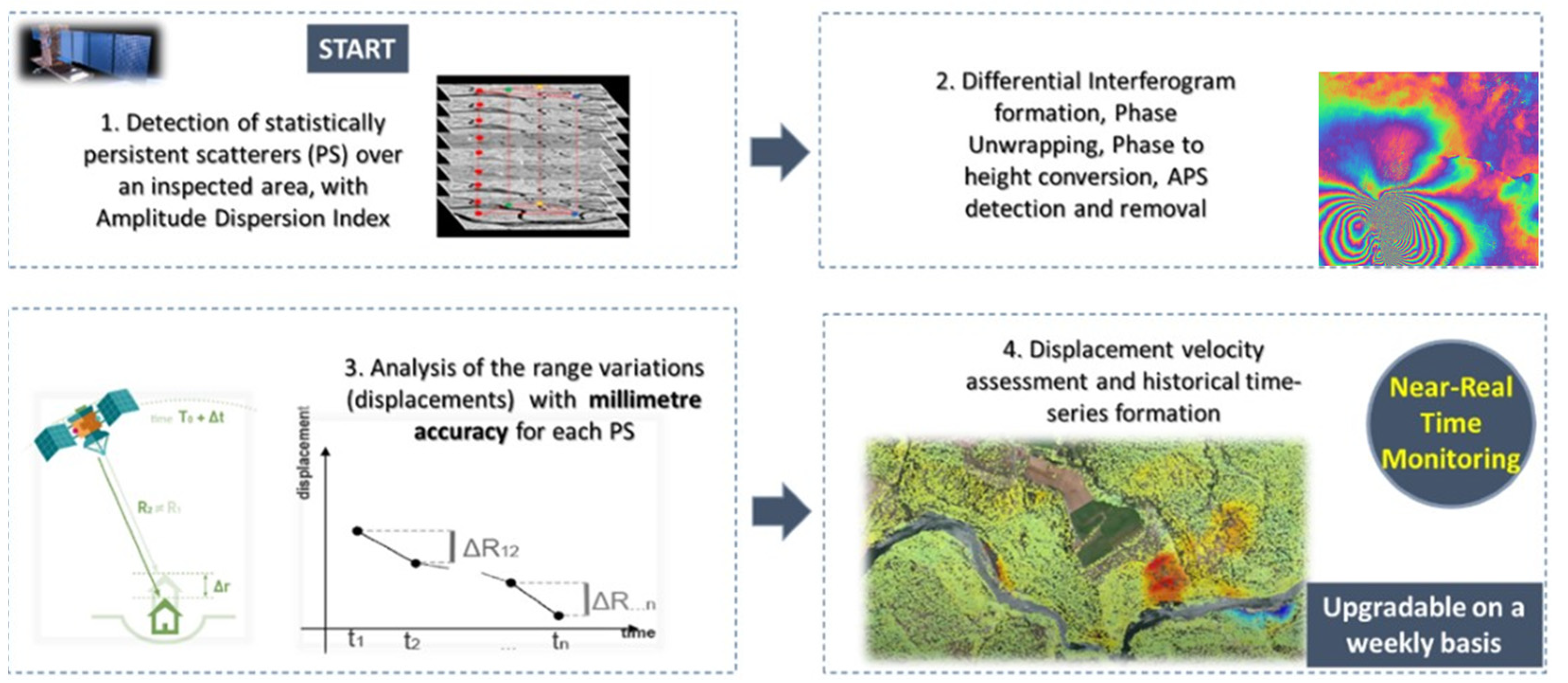
After the selection process of the pixels as PSCs, these are used in a combined spatial and temporal analysis to estimate the atmospheric phase screen (APS). This is associated with the atmospheric delay affecting the phase term for each interferogram. After removing the contribution of APS from the interferograms, an estimate of the deformations and errors in the DEM can be performed by examining both the temporal evolution and the geometric baseline variation in each pixel. An overview of the PS-InSAR algorithm is given in [14,15]. This was the first algorithm implementing the persistent scatterer approach. The method is suitable for analysing small areas at the same time, up to a maximum of 5 km × 5 km dimensions. This is linked to the main assumption that the atmosphere can be modelled effectively as a linear plane, meaning that several sub-areas can be processed to cover wider areas. The method involves the following steps, as reported in Figure 7:
-
co-registration and interferograms generation;
-
removing the topography phase terms using an external DEM;
-
identification of the PSC points from the SAR amplitude statistics by computation of the Amplitude Dispersion Index (ADI);
-
using the PS points to detect linear deformations and atmospheric effects;
-
generating the APSs for each interferogram;
-
removing the atmospheric noise contribution from each interferogram;
-
computing differential phase interferograms, identifying PS points through phase statistics and coherence values;
-
geocoding phase: converting the outputs in geographical coordinates and exporting the outputs into other formats (e.g., kml, csv, shp), for further incorporation into a GIS platform.
The PSI technique allows measurement of the rate of deformation along the LOS of the sensor, i.e., the direction connecting the sensor to the object, related to the incidence angle of the SAR sensors (Figure 8). Several approaches have been presented to solve this problem using the decomposition of the velocity vector combining SAR data collected in different acquisition geometries, (i.e., ascending and descending) [79].

5.2. Overview of the SAR Satellite Missions

A general overview of the main SAR satellite missions from 1992 to 2022 is reported in Figure 9. Since 2007, the second generation of space-borne SAR missions, including (i) the mission COSMO- SkyMed (CSK), developed by the Italian Space Agency (ASI) in collaboration with the Italian Minister of Defence, (ii) the TerraSAR-X (TSX), developed by the German Aerospace Centre (DLR), and (iii) the European satellites Sentinel-1A/B (SNT) of the European Union’s Earth Observation Programme Copernicus, implemented in partnership with the European Space Agency (ESA), provided a spatial resolution of metres for the pixels and a temporal resolution of a few days (i.e., 12 days for SNT and up to 1 day for CSK). These new advancements increased the density of PSs extracted from high-resolution SAR data up to five times compared to the first-generation SAR missions with medium resolution, i.e., the RADARSAT-1 and the Envisat missions. The provision of a very high spatial density, a wider coverage and the ability to detect deformations with a millimetre-level accuracy, has driven the use of satellite remote sensing towards the analysis of deformations in large infrastructure facilities, including bridges, roadways and airport runways. Specifically, the MT-InSAR techniques have proven very effective in infrastructure monitoring.

ASI’s COSMO-SkyMed Mission: Overview and Current Status

COSMO-SkyMed represents the largest Italian investment in space Earth Observation (EO) systems and one of the most advanced constellations at the international level. A general description of the architecture of the COSMO-SkyMed system is given in [80,81,82]. It is a satellite constellation owned by ASI (75%) and the Italian Ministry of Defense (25%). It is designed for a dual purpose (i.e., civil and defense sectors) and is currently in its second generation. The system was entirely developed and produced in Italy by Thales Alenia Space Italy (TAS-I) as the prime contractor, with the support of Telespazio S.p.A. and Selex Galileo [81,82]. The first generation of COSMO-SkyMed includes four satellites, launched in the period between June 2007 and November 2010, from the Vandenberg base (USA). Each satellite is equipped with a high-resolution multimode SAR sensor operating in X-band (9.6 GHz) that can acquire images with very high-spatial resolution up to 1 m, and revisiting times of days up to 12 h (i.e., in emergency cases). The system allows for high-quality and millimetre-level accuracy required both for interferometric and monitoring activities, which makes it ideal for the monitoring of transport assets. One of the key features of the CSK SAR sensors is in the possibility of operating with different acquisition modes. The first mode is the “Spotlight”, which allows for very high-spatial resolution (up to 1 m) by concentrating the sensor on a relatively small area (10 × 10 km). The second mode is the “Stripmap”, which is the most popular amongst researchers, for instance, regarding its use in civil infrastructure investigations. This allows the acquisition of large areas (i.e., a scale of 30 or 40 km) with a spatial resolution of up to 3 m. Lastly, the “Scansar” mode is used for applications requiring a wide geographical coverage (swaths of 100 or 200 km) with a larger spatial resolution (up to 30 m). The system is equipped with a Payload Data Handling and Transmission (PDHT) for on-board storage and downlinking of SAR data. The first-generation satellites, despite being designed to guarantee a useful lifespan of 5 years, are currently still operational. CSK is one of the most used by both institutional and commercial users, providing information for about 15 years in the monitoring of landslides and critical infrastructure on a global scale. Following careful analyses, it was decided by ASI to deorbit the CSK-3 satellite after more than 13 years of operation, with a de-orbiting procedure beginning in May 2022. The second generation of COSMO-SkyMed (CSG) was developed to ensure an operational continuity to the mission. It includes four additional satellites, two of which were launched in December 2019 and February 2022 from Cape Canaveral (USA). The new CSG satellites are equipped with a multimode SAR sensor operating in X-band, with enhanced performance in terms of image quality and polarimetry (quadruple), acquisition mode, platform agility and data transmission. CSG satellites are positioned on the same orbital plane as the CSK satellites, with a 180° angle between CSG1 and CSG2, at an angle of 45° from the respective CSK satellites. Figure 10 shows the current orbital configuration of the COSMO-SkyMed satellites.
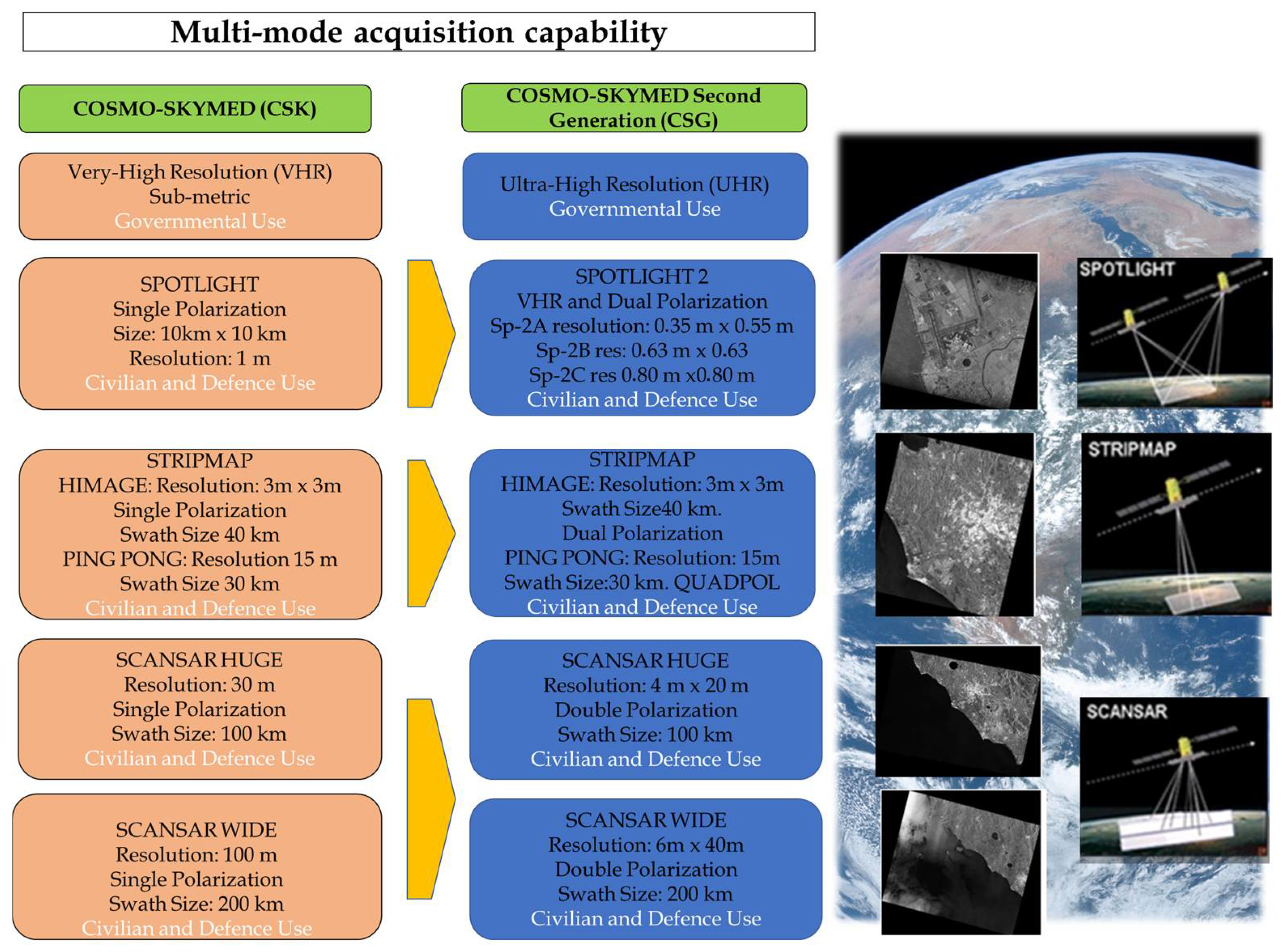
The interferometric revisit time of each satellite is 16 days, exactly matching the repeat cycle. The CSG1 and CSG2 satellites can perform interferometric acquisitions every 8 days, since they are positioned at 180° from each other on the same orbit. In the Stripmap mode it is also possible to carry out interferometric acquisitions between different CSK and CSG satellites. Figure 11 shows a comparison of performance offered by the acquisition modes between the first generation (CSK, in orange) and the second generation (CSG, in blue) of COSMO-SkyMed.
Regarding the future of the CSK System, the construction program for the 3rd and 4th satellites have recently been kicked off and these have been scheduled for launch in 2024 and 2025, respectively. A recent project will also provide the creation of the IRIDE constellation, which will become the most important multi-sensor European Earth Observation satellite space program at low altitude. This program is planned to be completed within the next five years (2027). IRIDE involves the use of SAR sensors operating in X-band and the possibility of an orbital choice, to be combined with the CSK/CSG constellation for interferometric applications, with a higher revisit time frequency. The project has been funded through the European funds of the Italian “Piano Nazionale di Ripresa e Resilienza (PNRR)” [83], as part of an agreement between ASI, ESA and the Italian Ministry for Innovation and Digital Transition (MITD). The constellation will also support civil protection and public administration bodies to monitor the hydrogeological instability of the environment, coasts, critical infrastructure, air quality and weather conditions.

5.3. Stand-Alone Applications of Satellite Remote Sensing for Infrastructure Monitoring

An overview of the most relevant PSI applications for the monitoring of transport infrastructure is reported in this section. Four major infrastructure classes are reviewed to cover the PSI applications, i.e., roadways, bridges, airports and railways, and the most relevant have been reported. A summary of the main information from the reviewed literature sources is reported in Table 2.

5.3.1. Roadways

Linear infrastructure in rural environment contexts are amongst the most reflective targets for SAR transmissions, triggering the formation of many PSs for the PSI analyses. This implies that the PSI technique can be inherently effective in the monitoring of major pavement distresses (e.g., rutting, deformations and settlements) in roadways. Several studies on the implementation of PSI for road infrastructure monitoring are reported in the literature. This demonstrates the interest of the scientific community in applying PSI techniques for the detection of damage and the identification of sections affected by significant displacements. In [84], a DInSAR analysis implementing the PSI and the SBAS approaches was carried out to detect displacements in the LOS of several urban motorways in Rome, Italy, including Motorways A1, A12, A24, A90 and A91. Both Sentinel-1 and COSMO-SkyMed SAR images were processed to detect PSs on the motorways and to identify sections affected by high subsidence, and were classified based on the PSI results. Xing et al. [85] implemented four widely used time-series deformation InSAR models (i.e., the multi velocity model (MVM), the permanent velocity model (PVM), the seasonal model (SM) and the cubic polynomial model (CPM) to measure the long-term ground deformation after construction of a road embankment on a soft clay subgrade. The SBAS-InSAR technique with TerraSAR-X satellite imagery was applied to generate the time series deformation data on the studied highway. Levelling data were also used to validate the experimental results, confirming that the InSAR method can reach a millimetre-level accuracy. Wasowski et al. [86] demonstrated the potential of the high-resolution PSI approach “SPINUA” in assisting asset owners with the assessment of structural hazards. Examples of PSI applied to monitor post-construction performance of engineering structures in Italy are also presented, including case studies on buildings and on the motorway Florence–Livorno. Karimzadeh et al. [87] implemented the SBAS InSAR technique for the detection of land subsidence and pavement structural monitoring. A comparison between the International Roughness Index (IRI) and the backscattering coefficient (dB) of CSK SAR images was conducted, proving a slight correlation between these parameters. Results also showed an urbanised area where buildings and 65 km of pavement sections are affected by the risk of land subsidence. Furthermore, Ozden et al. [88] demonstrated through an InSAR cost/benefit analysis that the use of SAR-based approaches can improve the effectiveness of the overall monitoring system and reduce total costs involved. The authors conclude that the PSI outcomes are viable indicators to predict the condition of road infrastructure assets. More recently, Macchiarulo et al. [89] demonstrated the feasibility of a fully automated GIS analysis of PSI time-series to detect critical PS points located on motorways at the network level. A Sentinel-1 dataset from 2016 to 2019 was used to analyse the Los Angeles highway and freeway network, whereas historical ERS/Envisat datasets (from 1992 and 2010), COSMO-SkyMed datasets (from 2008 to 2014) and Sentinel-1 datasets (from 2014 to 2020) were utilised to analyse the Italian motorway network. In general, these studies demonstrate that the PSI technique can be an effective monitoring tool for roadways and highways. It has been noticed that if the PSs density is not high, or if stable reflectors are not recognised on the road asset even with high-resolution data, the MT-InSAR results could still be used by asset managers to prioritise assets in case ground-based monitoring systems are installed. This application is currently under development, and several new processing techniques, such as the Quasi-PS technique [72] or the distributed scatterers, have proven effective to detect partially coherent PS points. The installation of corner reflectors, or artificial persistent scatterers, is an alternative solution to tackle this problem in infrastructure with a scarcity of PSs [91]. Corner reflectors are cheaper to utilise than on-site and ground-based monitoring equipment, and they can be installed in strategic sections of the structure to produce effective reflections. This allows more efficient recognition of these targets as PSs during the processing phases.

5.3.2. Bridges

In the last few years, research has been produced regarding the monitoring of bridges with satellite remote sensing techniques and the investigation of the surrounding environment. Amongst the most recent applications, great interest has been paid to the monitoring of historical bridges and cultural heritage sites. It is known that vertical and horizontal displacements at the piers of bridges may seriously compromise their structural stability. This occurrence is generally related to geodynamic (e.g., the sliding of the slope) or geotechnical factors (e.g., oedometric subsidence at the piles). The application of the PSI technique, and in general, the SAR-based processing methods, has been successful in reference to the evaluation of the structural components of bridges. To elaborate, the linear deformation trend, the height of the structure over the terrain, and the thermal expansion have been proven to create variations in the SAR phase [92,93]. Several successful applications can demonstrate the viability of using MT-InSAR techniques on bridge infrastructure and the possibility of detecting displacements and accelerations. More specifically, the MT-InSAR has been used to reconstruct the thermal expansion of reinforced concrete or truss bridges, as reported in Table 2 [92,93,94,95,96]. A further area of investigation is related to the integration of MT-InSAR deformation outputs into 3D finite element models of the inspected bridge [97,98]. Research works have used historical SAR images to monitor bridge displacements over long periods of observation by assessing their structural stability or predicting collapse conditions in complex scenarios [99,100]. To this purpose, relevant case studies have been analysed, including the collapse of the “Morandi Bridge” in Genova, Italy, which involved 43 victims. Milillo et al. [101] present a study conducted after the bridge collapse, using a dataset of SAR images acquired by the Sentinel-1 (C-Band), the COSMO-SkyMed (X-Band) and the ENVISAT missions. A non-conventional PSI approach was here implemented that located several reference points, in one of the bridge decks and detected several down-lifting PS points. For these points, an increased velocity of deformation was observed in the investigated time frame before the structural collapse. The COSMO-SkyMed dataset in the time frame March 2017–August 2018 revealed an increased deformation magnitude of several PSs located near the strands of the deck next to the collapsed pier. Lanari et al. [102] published a subsequent comment article in response to the study by Milillo et al. [101] where the same SAR dataset was processed with the SBAS and the TOMOSAR techniques. No critical PSs affected by down-lifting displacements were detected over the bridge. The authors excluded the possibility of predicting rapid movements, and hence, of predicting the collapse of the Morandi bridge by MT-InSAR.
In general, these studies demonstrate an overall good interest of the scientific community for these areas of application and the need to implement additional research in complex scenarios. This includes the possibility of using data from other SAR missions to improve the temporal frequency of the datasets. MT-InSAR techniques have gained momentum and are becoming more consolidated, as their real-life applicability has also been demonstrated against on-site levelling and GPS measurements. Hence, satellite remote sensing monitoring has gained consideration as one of the most promising techniques for the systematic monitoring of transportation assets. An integrated use of remote sensing and on-site sensors (e.g., accelerometers, GPR, UAVs, laser scanners and optical fibres) can also support the use of this technology in monitoring activities as well as in the interpretation of the results.

5.3.3. Airports

This section reports an overview of research about the use of PSI techniques in airport monitoring, with a focus on runways and their surrounding areas. Jiang et al. [103] present a case study on the deformation monitoring and the analysis of the geological environment at the Shanghai Pudong International Airport, China. A qualitative spatial–temporal analysis of the ground deformations found a correlation between the InSAR measurements and the variations observed in the geological environment. This was achieved by implementing a multi-temporal InSAR approach to identify several down-lifting displacement areas. Jiang et al. [104] present an integrated analysis of SAR interferometric and geological data for the investigation of long-term reclamation settlements at the Chek Lap Kok Airport, Hong Kong. Relying on a dataset of ascending and descending images acquired by the ENVISAT ASAR mission and a sparse levelling campaign, the authors could effectively link the deformation trend observed in the areas of the airport to the geotechnical properties of the soils, with a special focus on the area reclaimed by the sea. The same settlement was examined by Wu et al. [105] through an extensive InSAR analysis covering two decades of observations. The authors merged information from various multi-temporal datasets of different sources (i.e., ERS-2, ENVISAT ASAR, COSMO-SkyMed and Sentinel-1A). The outcomes were compared to the data collected using GNSS stations located in the airport area as well as to available geological data. The scope was to monitor the ground settlements following a sea reclamation land from construction of the Xiamen New Airport, China. The study reports significant information for airport land reclamation design purposes and the next stages of the construction process. Gao et al. [106] present research on the monitoring of the Beijing Capital International Airport, China, which is affected by severe down-lifting deformations. The authors demonstrate that the observed settlements were related to the variation of the groundwater levels. In general, existing research has widely proven the effectiveness of the InSAR analyses for the interpretation of geological and geotechnical features in areas of interest for the airports [107,108]. These studies also clearly demonstrate the reliability of the InSAR technique in reconstructing the actual vertical displacements, with very limited differences across the adopted frequency band and the acquisition geometry, given the quasi-vertical principal direction of the deformations.

5.3.4. Railways

Railway systems consist of interconnected infrastructure, including bridges and tunnels, where individual elements not working at full capacity across their service life can affect the functionality of the entire system. The use of MT-InSAR methods has increased in the last few years due to their ability to collect information with a millimetre-level accuracy. Successful applications of the PSI technique in railway monitoring are reported in Table 2. Amongst the most significant studies in this area, Chang et al. [109] proposed a probabilistic method for InSAR time series post-processing to efficiently analyse the data and detect railway structural instabilities. The proposed approach was validated on the entire railway network of the Netherlands, using 213 Radarsat-2 acquisitions between 2010 and 2015. More than 3000 km of railway sections were analysed, leading to the first satellite-based nationwide application for railway monitoring. Luo et al. [110] conducted a high-resolution MT-InSAR survey to monitor the Jingjin Inter-City Railway, in Tianjin (China), and validated their results with levelling measurements of high spatial/temporal density. The outcomes show a high correlation between the measurements collected with the two different methods. A total of 37 TerraSAR-X images covering a 6-month period were processed by the MT-InSAR analysis. The distance between two consecutive levelling points was 60 m along the railway, with these data being collected every month from August 2009 to January 2011. The Root Mean Square Error (RMSE) index resulting from the comparison between the average subsidence velocity of motion, detected by MT-InSAR and levelling surveys, was 3.28 mm/yr, with 34 points. Furthermore, the RMSE index from the displacements by MT-InSAR and levelling was relatively low, i.e., 2.90 mm for 464 valid observations. These analyses show that a millimetre-level accuracy can be achieved though the MT-InSAR analysis when monitoring subsidence on a high-speed railway.
Qin X. et al. [111] developed an improved persistent scatterer InSAR approach capable of retrieving and monitoring the thermal expansion effects in railways with an increased number of point-like targets (PTs). Velocity of subsidence, gradient and thermal dilation were implemented to identify the hazard risk associated with three railways selected as case studies. The proposed strategy combines the SAR amplitude, the interferometric phase and the spatial information of railway structures to maximise the number of PTs. The approach was validated using ENVISAT ASAR and TerraSAR-X (TSX) data.
It is important to emphasise that maintenance of railway bridges and their structural components, such as piers and shoulders, and the monitoring of their static and dynamic response are crucial tasks. Hence, the function of detecting differential deformations along the tracks makes the PSI methods very effective for safety and structural stability monitoring of infrastructure.

6. New Paradigms in Transport Infrastructure Monitoring: Combined Applications and Data Integration Studies of Satellite Remote Sensing and NDTs

The PSI technique can measure deformations at the location of the PSs. Hence, historically, their use has not been suitable for areas with high temporal decorrelation, e.g., vegetated areas or areas subject to rapid urbanisation [14,15]. These areas are characterised by the absence of stable points or reference infrastructure. Novel approaches (i.e., the distributed scatterers) can solve these problems in complex scenarios [71,72]. Another focus point is related to the medium-resolution associated with the frequency of the SAR sensors, which can make it difficult to allocate the PS to the actual object on the ground surface, or to the relevant structural element, especially in urbanised areas. Furthermore, the analysis of medium-resolution SAR data is crucial for the systematic monitoring of infrastructure at the network level as well as for territorial analyses. When anomalies are detected, a more detailed PSI analysis based on high-resolution SAR products (i.e., CSK) can be achieved over smaller areas and/or complemented with on-site inspections. Lastly, the PSI method can be subject to processing errors, mainly when selected reference points, which are assumed as stable, are subject to local movements. Currently, these issues still limit the stand-alone use of MT-InSAR methods as a routine asset management tool for the detection of deformations in transport structures. Hence, the synergistic use of PSI techniques with complementary ground-based NDT methods stands as the most viable and up-to-date solution to cover these gaps.
The use of ground-based NDT methods for the assessment of transport infrastructure has increased significantly in the past few decades. Several applications and case studies carried out by means of indirect non-invasive technologies have been successfully presented in the literature, proving their contribution to enhancing the productivity of asset monitoring activities. Research advances on the use of ground-based NDT methods have been reported in many areas of transportation and pavement engineering, including applications on highways [112], railways [113,114] and airfields [115,116]. A wide availability of multi-source, multi-scale and multi-temporal information on infrastructure conditions, as well as the advancement of hardware and software technologies, have created new opportunities for further expansion in the application of NDT methods. The information produced lends itself to incorporation into existing infrastructure management models [117]. Relying on established design and verification guides [118,119], the rationale is to exploit the higher productivity of the ground-based NDT techniques and use the outcomes for incorporation into existing models for network infrastructure asset management. Within this context, it is observed that compliance to increasingly challenging budget and environmental goals is moving the research focus towards the development of more advanced, rapid and reliable NDT methods for pavement assessment. Efforts are being spent on the provision of continuous and faster measurements to replace existing non-destructive technologies based on discrete methods of data collection [120]. This is undoubtedly related to the higher requirements for the frequency of testing in certain types of infrastructure (e.g., railways and airfields) as well as to the inherent configuration of linear transport structures, where stop-and-go operations and partial or full-service interruption (e.g., lane closures) can dramatically affect their functionality and operability. New paradigms based on the use of non-destructive technologies have been therefore introduced, and other existing NDTs have been integrated in attempts to overcome resolution and data collection time limitations [13,113] and to exploit their full potential. The following paragraphs report an overview of studies and applications within the context of the use of InSAR and other NDTs techniques in infrastructure engineering, sorted by infrastructure type, i.e., roads, railways, airfields and bridges.
Research has confirmed the very high suitability of the InSAR techniques in detecting displacements for highways, motorways and road intersections, reaching a millimetre-level accuracy in the measurements. These applications have proven that, despite the abundant availability of PSs in urban areas, it could be challenging to associate the information with the concerned structural element, especially when medium-resolution SAR data (e.g., C-band) are utilised. This issue has been overcome by using last-generation SAR data acquired in X-band [121], where a pixel resolution up to 1 m can be reached. In this context, Alani et al. [122] conducted an experimental activity on the Aylesford area in Kent, UK, where a novel “integrated” holistic health monitoring approach—including the GPR and InSAR techniques—was proposed. The processing of COSMO-SkyMed Stripmap products demonstrated the high suitability of the PSI technique for road applications. More specifically, the analysis allowed the identification of several coherent PS points across various roads, bridges and buildings in the investigated area. The analysis was completed by GPR investigations providing structural details of the subsurface (i.e., the pavement structure of a river bridge). The approach enabled a clear mapping of the main subsurface structural features (GPR) in addition to producing long-term information on the behaviour of structures and infrastructure involved in this investigation (InSAR).
Similarly to roads, railways are generally recognised as stable scatterers and good infrastructure targets for InSAR monitoring. Detected ground displacements are caused by a variety of factors that may be linked to the subsurface. In this regard, GPR technology lends itself to incorporation into InSAR investigations of railway infrastructure. In [17], the authors investigated a railway located in Puglia, Italy, using the satellite remote sensing PSI technique and the GPR technology, which was mounted on inspection trains. The PSI analysis allowed identification of critical sections through the detection of PSs affected by subsidence in the examined railway area (Figure 12). Both medium-resolution (C-band) and high-resolution (X-band) satellite data were used for the purpose. An in-depth analysis of the GPR radargrams enabled the association of areas affected by high attenuation of the signal with the critical sections identified by the InSAR analyses (Figure 12).
To elaborate, the authors observed weak reflections at the interface between the sub-ballast layer and the subgrade, showing discontinuous patterns in the radargrams. This was likely related to fouling and clay intrusion at the ballast-foundation level. With similar scopes and approaches, Tosti et al. [123] monitored a railway section affected by subsidence. A clear match was found between areas with displacements and areas affected by potential fouling through InSAR and GPR techniques, respectively. Sections with high attenuation of the GPR signal at the foundation level were found to match with sections where the highest subsidence was observed through the InSAR analyses. In general, these studies have proven the effectiveness of integrating satellite and ground-based information for structural health monitoring of railways. In the same study area, D’Amico et al. [124] used InSAR and GPR technologies for monitoring the rail-abutment transition area in a railway truss bridge overpassing a motorway. GPR was utilised to collect subsurface structural details of the railway superstructure/substructure, including ordinary rail sections before and after the bridge section. Outcomes from the GPR surveys excluded any potential construction-related issue. A section of the railway at one of the approaches was found to be affected by the high reflectivity of the signal at the ballast-foundation level. This section matched with an area of subsidence clearly identified by the PS-InSAR analysis carried out over the entire railway section in this study. By combining the information from GPR and InSAR, the authors concluded that inadequate compaction of the ballasted layers could have been the main cause of differential displacements at the rail abutment transition area.
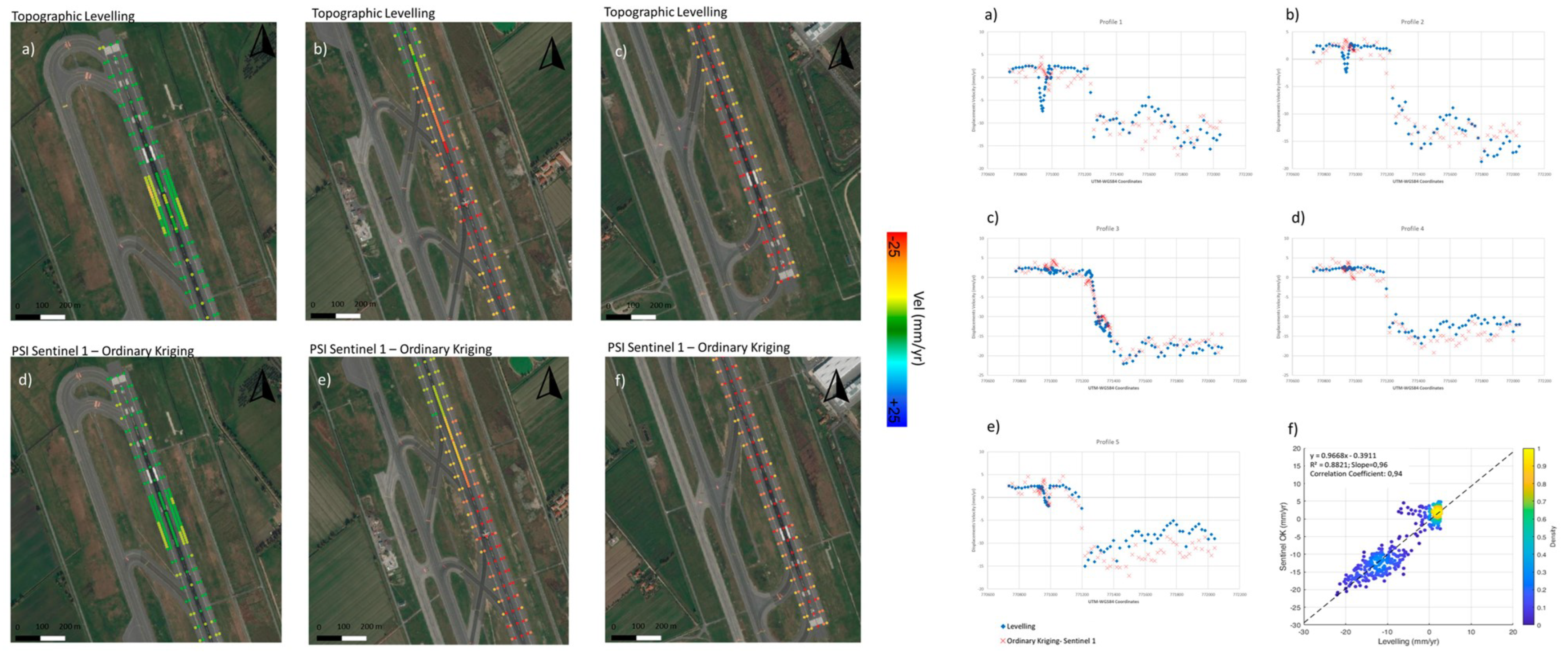
Amongst the most recent applications conducted on airports, Gagliardi et al. [108] presented a study carried out on Runway n. 3 at the Leonardo Da Vinci International Airport in Fiumicino, Rome, Italy. Two different SAR datasets were processed, including (i) Sentinel-1 (C-band) data in both the acquisition geometries (i.e., ascending and descending), and (ii) COSMO-SkyMed (X-band) data. Furthermore, measurements were also compared with those collected on the runway using the ground-based levelling technique. The SAR datasets covered a time frame from April 2017 to December 2019. The aim of the study was to test and investigate the viability of using medium-resolution SAR interferometry data in monitoring ground displacements on runways at the millimetre scale, in a complex scenario affected by a well-known subsidence of different severity affecting the runway. A geostatistical analysis was developed to (i) study the statistical variability of the datasets, (ii) interpolate the Sentinel-1 data through an ordinary kriging (OK) method and (iii) compare the interpolated displacements to the values collected on-site by topographic levelling. Figure 13 shows the main outcomes from the use of ground-based topographic levelling data and satellite remote sensing data on the runway. A comparison between the PSI outcomes from the Sentinel-1A SAR data interpolated through OK and the ground-truth topographic levelling data demonstrated a relatively high accuracy of the medium-resolution data. This was proven by the high values of the correlation coefficient (r = 0.94) and the multiple R-squared coefficient (R2 = 0.88) comparing levelling and SAR data [125].
In [125], an InSAR investigation was conducted into the differential settlements at one of the runways at the Fiumicino International Airport in Rome, Italy. Several COSMO-SkyMed X-band SAR images were processed by means of the PS-InSAR approach, highlighting the presence of vertical displacements. These were compared to the outputs from a dense levelling campaign conducted over four years. The accuracy of the results confirmed that PSI analyses of high-frequency images are very effective in reconstructing vertical deformations in airfield runways.
Bridge monitoring is a further area of investigation where the integrated approach has proven effective. Literature shows increasing research for use of ground-based NDTs, especially GPR, as fundamental investigation tools in bridge diagnostics [126,127]. Although the above methodologies can collect reliable information, a fully comprehensive and routine diagnostics of the bridge conditions cannot be achieved if these techniques are utilised individually. To this end, the integration of multi-source, multi-temporal and multi-resolution datasets is a challenge and an area of further research development. Research in [128] explored how InSAR datasets can be combined with traditional measurement techniques including automated total stations and sensors installed on the Waterloo Bridge, a 434-m long concrete bridge carrying the A301 across the River Thames in London, UK. A novel approach to InSAR bridge monitoring was adopted by the installation of corner reflectors at key points of structural interest on the bridge, to supplement the bridge’s own reflection characteristics and ensure that the InSAR measurements could be directly compared and combined with measurements collected on site. A strategy to combine and interpret various data from multiple sources was presented, outlining the practical applications of this data analysis to support wider monitoring strategies. In [129,130], the viability of using X-band SAR imagery for effective monitoring of historical bridges was investigated. A dataset of X-band data, acquired by ASI in the framework of the COSMO-SkyMed mission, was processed for the monitoring of the Rochester Bridge, UK. In [130], a clustering technique based on the data semantic of the PSs observed in the bridge area allowed the allocation of relevant information to individual structural elements of the bridge, such as piers and arcs. To quantitatively evaluate the PSI results, the profile of the spatial distributions of the average deformation velocity (mm/yr) related to the PSs on the road bridge along the longitudinal axis was investigated [130]. Overall, a range of variation of a few millimetres for the observed displacements was noticed across maximum and minimum values. No critical areas or significant subsidence were detected for the relevant PS data clusters. The aforementioned studies clearly show a growing interest in the application of integrated approaches to assess the health and internal condition of transport structures, paving the way for further investigations and research studies.

7. Advances, Benefits and Challenges for Network-Level Infrastructure Monitoring with Satellite Remote Sensing and NDTs

It is well recognised that decay and ageing exacerbate the costs of maintenance. Asset owners allocate considerable funding to road infrastructure, rail maintenance and repairing operations to ensure structural integrity and proper serviceability of the network system. It is therefore important to monitor the infrastructure and its individual structural elements (e.g., superstructures, piers, decks) with effective solutions and technologies. This allows the maintenance of high standards for the structures’ mechanical responses, resistance to fatigue loads and resistance to geohazard events (e.g., earthquakes and sudden subsidence), all of which can affect the integrity of infrastructure assets.
The main concept of an integrated health monitoring model is reported in Figure 14. This is representative of a synergistic analysis of outputs from satellite remote sensing and NDT technologies. This integrated approach relies on information available from asset owners’ databases, made up of geographical asset location, as-built information of identified infrastructure network elements. The main novelties are related to the implementation of data from historical monitoring and maintenance interventions, which can be used as a starting point to reconstruct historical series from the monitoring of the target infrastructure. Accordingly, the model is characterised by two synchronised routine monitoring stages by two levels of data coverage, i.e., the local level for the use of NDTs and the network level for the implementation of satellite remote sensing techniques. Where critical sections are identified, local inspections can be carried out with dedicated NDT techniques. This is intended to build up a more comprehensive information system on the type and scale of the developing distress at the identified sections. The information obtained at this stage forms the basis of prediction models for the evaluation of stresses and anomalies. These models can support assessment of whether maintenance or rehabilitation is required and of the priority level to be assigned to the identified intervention. Sections not labelled with any critical occurrence are subject to new screening phases at predetermined time intervals. The main aim of this phase is to assess any potential distress in the infrastructure in terms of the extent of the degradation (e.g., portion of the asset affected by low bearing capacity of the subgrades), causes (e.g., the presence of fine materials in the subbase courses) and effects (e.g., low-stiffness sections observed by deflection tests) that cannot be detected by satellite remote sensing.
The sources of damage can be effectively identified by GPR as potential causes for the displacements detected by MT-InSAR. In general, the integration of satellite remote sensing and ground-based techniques into data-integration and data-fusion algorithms stands as a challenging topic for further investigation in the systematic monitoring of infrastructure assets.

8. Conclusions, Challenges and Future Perspectives

This paper reviews new developments and applications of satellite remote sensing and ground-based non-destructive testing (NDT) methods in transport infrastructure monitoring. Special focus is given to the integration between these two areas of technology and their most recent applications in the field. Overall, it is observed that excellent progress has been made in terms of the provision of high standards of data quality and accuracy. However, a stand-alone use of these technologies is naturally constrained by physical (e.g., limitations in terms of nominal data resolutions of the equipment) and productivity (e.g., limitations in terms of land coverage or data acquisition pace) factors, which poses an issue on how to enhance their applicability in the sector. The concept of “technology and data integration” is one of the options in answering this fundamental research question. In this regard, it has emerged that new research has been carried out on combined applications and data integration studies involving satellite remote sensing and ground-based NDT methods across all the transport infrastructure modes (highways, railways and airfields). Furthermore, historical bridges have been a focus of recent research involving these two areas of technology. At present, ground-penetrating radar (GPR) stands as a popular technology for integration with Interferometric Synthetic Aperture Radar (InSAR) techniques. This is due to the possibility of collecting data on the subsurface features and providing a more comprehensive diagnostics of the causes of ground displacements. On the other hand, the concept of integration triggers some challenges that can be summarised as follows.
  • Existing permanent scatterer (PS) approaches have proven to work effectively. However, there are limitations in terms of target accuracy that can limit their applicability in certain areas of transport engineering.
  • The variety of techniques available as well as the differences in the physics and working principles of the inspection equipment make it complex to identify the actual gaps in the quality and type of information provided. A clear matching between these gaps and the actual needs in transport infrastructure monitoring is still a point of debate.
  • Although several NDT methods have gained official recognition as fundamental tools for integration in infrastructure management systems (IMSs), it is observed that satellite remote sensing techniques have not yet entered that stage. At present, this condition could stand as a limitation for any potential development based on the integration between these two areas of technology.
The above challenges could be also looked at as prospective points of research development, as follows:
  • To investigate more deeply into the development of new potential SAR analysis methods using innovative permanent scatterer (PS) approaches (e.g., non-linear displacement models, integrated persistent scatterers interferometry (PSI) -small baseline subset (SBAS) approaches and distributed scatterers (DS) methods).
  • To orient research towards filling the gaps left by the stand-alone use of individual technologies, promoting their integration. A comprehensive theoretical and practical knowledge of these techniques as well as of the actual needs of several transport infrastructure sectors is essential to identify the right direction. It is the authors’ opinion that the implementation of advanced machine learning and deep neural networks (DNN) algorithms can support this process.
  • To invest in the development of more advanced IMSs with the capacity and resources to integrate satellite remote sensing and ground-based technologies at the network level.

Author Contributions

Conceptualization, V.G., F.T., M.L.B. and A.B.; methodology, V.G. and F.T.; formal analysis, V.G., F.T., L.B.C., L.D. and A.B.; investigation, V.G.; data curation, V.G.; writing—original draft preparation, V.G.; writing—review and editing, V.G., F.T., M.L.B., L.D., A.M.A. and A.B.; supervision, V.G., F.T. and A.B. All authors have read and agreed to the published version of the manuscript.

Funding

This research falls within the National Project “Extended Resilience Analysis of Transport Networks” (EXTRA TN), PRIN 2017, Prot. 20179BP4SM supported by the Italian Ministry of Education, University and Research (MIUR) and the Project “MLAZIO” funded by Lazio Region (Italy). In addition, the authors acknowledge funding from the MIUR, in the frame of the “Departments of Excellence Initiative 2018–2022”, attributed to the Department of Engineering of Roma Tre University.

Acknowledgments

The authors acknowledge the Italian Space Agency for the fruitful collaboration.

Conflicts of Interest

The authors declare no conflict of interest.

References

  1. Chang, P.C.; Flatau, A.; Liu, S.C. Review Paper: Health Monitoring of Civil Infrastructure. Struct. Health Monit. 2003, 2, 257–267. [Google Scholar] [CrossRef]
  2. Chen, K.; Lu, M.; Fan, X.; Wei, M.; Wu, J. Road condition monitoring using on-board Three-axis Accelerometer and GPS Sensor. In Proceedings of the 2011 6th International ICST Conference on Communications and Networking in China, Harbin, China, 17–19 August 2011; pp. 1032–1037. [Google Scholar] [CrossRef]
  3. Olund, J.; DeWolf, J. Passive Structural Health Monitoring of Connecticut’s Bridge Infrastructure. J. Infrastruct. Syst. 2007, 13, 330–339. [Google Scholar] [CrossRef]
  4. Sato, H.P.; Abe, K.; Ootaki, O. GPS-measured land subsidence in Ojiya City, Niigata Prefecture. Japan. Eng. Geol. 2003, 67, 379–390. [Google Scholar] [CrossRef]
  5. Mossop, A.; Segall, P. Subsidence at The Geysers Geothermal Field, N. California from a comparison of GPS and leveling surveys. Geophys. Res. Lett. 1997, 24, 1839–1842. [Google Scholar] [CrossRef] [Green Version]
  6. Saarenketo, T.; Scullion, T. Road evaluation with ground penetrating radar. J. Appl. Geophys. 2000, 43, 119–138. [Google Scholar] [CrossRef]
  7. Benedetto, A.; Tosti, F.; Ciampoli, L.B.; D’Amico, F. GPR Applications across Engineering and Geosciences Disciplines in Italy: A Review. IEEE J. Sel. Top. Appl. Earth Obs. Remote Sens. 2016, 9, 2952–2965. [Google Scholar] [CrossRef]
  8. Bianchini Ciampoli, L.; Artagan, S.S.; Tosti, F.; Gagliardi, V.; Alani, A.M.; Benedetto, A. A comparative investigation of the effects of concrete sleepers on the GPR signal for the assessment of railway ballast. In Proceedings of the 17th International Conference on Ground Penetrating Radar (GPR), Rapperswil, Switzerland, 18–21 June 2018; pp. 1–4. [Google Scholar] [CrossRef]
  9. Rashidi, M.; Mohammadi, M.; Kivi, S.S.; Abdolvand, M.M.; Truong-Hong, L.; Samali, B. A Decade of Modern Bridge Monitoring Using Terrestrial Laser Scanning: Review and Future Directions. Remote Sens. 2020, 12, 3796. [Google Scholar] [CrossRef]
  10. Bianchini Ciampoli, L.; Calvi, A.; Di Benedetto, A.; Fiani, M.; Gagliardi, V. Ground Penetrating Radar (GPR) and Mobile Laser Scanner (MLS) technologies for non-destructive analysis of transport infrastructures. In Proceedings of the Earth Resources and Environmental Remote Sensing/GIS Applications XII, Online, 12 September 2021. [Google Scholar] [CrossRef]
  11. Lagüela, S.; Solla, M.; Puente, I.; Prego, F.J. Joint use of GPR, IRT and TLS techniques for the integral damage detection in paving. Constr. Build. Mater. 2018, 174, 749–760. [Google Scholar] [CrossRef]
  12. Monserrat, O.; Crosetto, M.; Luzi, G. A review of groundbased SAR interferometry for deformation measurement. ISPRS J. Photogramm. Remote Sens. 2014, 93, 40–48. [Google Scholar] [CrossRef] [Green Version]
  13. Tosti, F.; Gagliardi, V.; Ciampoli, L.B.; Benedetto, A.; Threader, S.; Alani, A.M. Integration of Remote Sensing and Ground-Based Non-Destructive Methods in Transport Infrastructure Monitoring: Advances, Challenges and Perspectives. In Proceedings of the 2021 IEEE Asia-Pacific Conference on Geoscience, Electronics and Remote Sensing Technology (AGERS), Jakarta Pusat, Indonesia, 29–30 September 2021; pp. 1–7. [Google Scholar] [CrossRef]
  14. Ferretti, A.; Prati, C.; Rocca, F. Permanent scatterers in SAR interferometry. IEEE Trans. Geosci. Remote Sens. 2001, 39, 8–20. [Google Scholar] [CrossRef]
  15. Ferretti, A.; Prati, C.; Rocca, F. Nonlinear subsidence rate estimation using permanent scatterers in differential SAR interferometry. IEEE Trans. Geosci. Remote Sens. 2000, 38, 2202–2212. [Google Scholar] [CrossRef] [Green Version]
  16. Lanari, R.; Mora, O.; Manunta, M.; Mallorqui, J.J.; Berardino, P.; Sansosti, E. A small baseline approach for investigating deformation on full resolution differential SAR interferograms. IEEE Trans. Geosci. Remote Sens. 2004, 42, 1377–1386. [Google Scholar] [CrossRef]
  17. Bianchini Ciampoli, L.; Gagliardi, V.; Clementini, C.; Latini, D.; Del Frate, F.; Benedetto, A. Transport Infrastructure Monitoring by InSAR and GPR Data Fusion. Surv. Geophys. 2020, 41, 371–394. [Google Scholar] [CrossRef]
  18. Tosti, F.; Benedetto, A.; Ciampoli, L.B.; D’Amico, F.; Plati, C.; Loizos, A. Guest Editorial: Data Fusion, integration and advances of non-destructive testing methods in civil and environmental engineering. NDT E Int. 2020, 115, 102286. [Google Scholar]
  19. Tosti, F.; Alani, A.M.; Benedetto, A.; Loizos, A.; Soldovieri, F. Guest Editorial: Recent Advances in Non-destructive Testing Methods. Surv. Geophys. 2020, 41, 365–369. [Google Scholar] [CrossRef] [Green Version]
  20. Linee Guida per la Classificazione e Gestione Del Rischio, la Valutazione della Sicurezza ed il Monitoraggio dei Ponti Esistenti, MIMS e CSLLP. Available online: https://www.mit.gov.it/sites/default/files/media/notizia/2020-05/1_Testo_Linee_Guida_ponti.pdf (accessed on 1 September 2022).
  21. Meng, X.; Dodson, A.H.; Roberts, G.W. Detecting bridge dynamics with GPS and triaxial accelerometers. Eng. Struct. 2007, 29, 3178–3184. [Google Scholar] [CrossRef]
  22. Moschas, F.; Stiros, S. Measurement of the dynamic displacements and of the modal frequencies of a short-span pedestrian bridge using GPS and an accelerometer. Eng. Struct. 2011, 33, 10–17. [Google Scholar] [CrossRef]
  23. Hu, X.; Wang, B.; Ji, H. A Wireless Sensor Network-Based Structural Health Monitoring System for Highway Bridges. Comput.-Aided Civ. Infrastruct. Eng. 2013, 28, 193–209. [Google Scholar] [CrossRef]
  24. Chae, M.J.; Yoo, H.S.; Kim, J.Y.; Cho, M.Y. Development of a wireless sensor network system for suspension bridge health monitoring. Autom. Constr. 2012, 21, 237–252. [Google Scholar] [CrossRef]
  25. Solla, M.; Lagüela, S.; Riveiro, B.; Lorenzo, H. Non-destructive testing for the analysis of moisture in the masonry arch bridge of Lubians (Spain). Struct. Control Health Monit. 2013, 20, 1366–1376. [Google Scholar] [CrossRef]
  26. Orbán, Z.; Yakovlev, G.; Pervushin, G. Non-Destructive Testing of masonry arch bridges—An overview. Bautechnik 2008, 85, 711–717. [Google Scholar] [CrossRef]
  27. Barbarella, M.; Di Benedetto, A.; Fiani, M.; Guida, D.; Lugli, A. Use of DEMs Derived from TLS and HRSI Data for Landslide Feature Recognition. ISPRS Int. J. Geo-Inf. 2018, 7, 160. [Google Scholar] [CrossRef] [Green Version]
  28. Al-Qadi, I.; Lahouar, S.; Loulizi, A. Successful Application of Ground-Penetrating Radar for Quality Assurance-Quality Control of New Pavements. Transp. Res. Rec. J. Transp. Res. Board 2003, 1861, 86–97. [Google Scholar] [CrossRef]
  29. Al-Qadi, I.L.; Leng, Z.; Lahouar, S.; Baek, J. In-Place Hot-Mix Asphalt Density Estimation Using Ground-Penetrating Radar. Transp. Res. Rec. J. Transp. Res. Board 2010, 2152, 19–27. [Google Scholar] [CrossRef] [Green Version]
  30. Hoła, J.; Schabowicz, K. State-of-the-art non-destructive methods for diagnostic testing of building structures—Anticipated development trends. Arch. Civ. Mech. Eng. 2010, 10, 5–18. [Google Scholar] [CrossRef]
  31. Berndt, E.; Schone, I. Tragverhalten von Natursteinmauerwerk aus Elbesandstein. Sonderforschungsbereich 1991, 315, 183–189. [Google Scholar]
  32. Colla, C.; Das, P.; McCann, D.; Forde, M. Sonic, electromagnetic and impulse radar investigation of stone masonry bridges. NDT E Int. 1997, 30, 249–254. [Google Scholar] [CrossRef]
  33. Williamson, P.R. A guide to the limits of resolution imposed by scattering in ray tomography. GEOPHYSICS 1991, 56, 202–207. [Google Scholar] [CrossRef]
  34. Yang, Z.; Schmid, F.; Roberts, C. Assessment of Railway Performance by Monitoring Land Subsidence’, Railway Condition Monitoring (RCM 2014). In Proceedings of the 6th IET Conference on Railway Condition Monitoring (RCM 2014), Birmingham, UK, 17–18 September 2014; pp. 1–6. [Google Scholar] [CrossRef]
  35. Quinci, G.; Gagliardi, V.; Pallante, L.; Manalo, D.R.J.; Napolitano, A.; Bertolini, L.; Bianchini Ciampoli, L.; Meriggi, P.; D’Amico, F.; Paolacci, F. A novel bridge monitoring system implementing ground-based, structural and remote sensing information into a GIS-based catalogue. In Proceedings of the SPIE 12268, Earth Resources and Environmental Remote Sensing/GIS Applications XIII, Berlin, Germany, 26 October 2022; 8. [Google Scholar] [CrossRef]
  36. Available online: www.scopus.com (accessed on 1 September 2022).
  37. Ip, W.H.; Wang, D. Resilience and Friability of Transportation Networks: Evaluation, Analysis and Optimization. IEEE Syst. J. 2011, 5, 189–198. [Google Scholar] [CrossRef]
  38. Deng, L.; Wang, W.; Yu, Y. State-of-the-art review on the causes and mechanisms of bridge collapse. J. Perform. Constr. Facil. 2016, 30, 04015005. [Google Scholar]
  39. Calvi, G.M.; Moratti, M.; O’Reilly, G.J.; Scattarreggia, N.; Monteiro, R.; Malomo, D.; Calvi, P.M.; Pinho, R. Once upon a Time in Italy: The Tale of the Morandi Bridge. Struct. Eng. Int. 2019, 29, 198–217. [Google Scholar] [CrossRef]
  40. Morgese, M.; Ansari, F.; Domaneschi, M.; Cimellaro, G.P. Post-collapse analysis of Morandi’s Polcevera viaduct in Genoa Italy. J. Civ. Struct. Health Monit. 2019, 10, 69–85. [Google Scholar] [CrossRef]
  41. Nadu, T. Experimental Investigation of Vibration Suppression for Avoiding Bridge Collapse by Pendulum Type Passive Tuned Mass Damping System. Int. J. Eng. Res. Technol. 2020, 9, 1156–1162. [Google Scholar]
  42. Čížek, P.; Kuboň, Z.; Kander, L. Material Analyses of Prestressed Concrete Bridge Failure; Material and Metallurgical Research: Ostrava, Czech Republic, 2021. [Google Scholar]
  43. Štulc, J. The 2002 Floods in the Czech Republic and their impact on built heritage. Herit. Risk 2008, 133–138. [Google Scholar] [CrossRef]
  44. Eckrich, G.D. Pfeiffer Canyon Bridge Failure within the Context of Risk. In Proceedings of the 70th Highway Geology Symposium, Portland, OR, USA, 21–24 October 2019. [Google Scholar]
  45. Roja, F.L. Filling potholes: Macroeconomic effects of maintenance versus new investments in public infrastructure. J. Public Econ. 2003, 87, 2281–2304. [Google Scholar] [CrossRef]
  46. Bengtsson, M.; Jackson, M. Important Aspect to take into Considerations when Deciding to Implement Condition Based Maintenance. 2004. Available online: https://www.semanticscholar.org/paper/Important-Aspects-to-take-into-Consideration-when-Bengtsson-Jackson/14bfcb8f096c9fad75fb527336713693970dff9f#citing-papers (accessed on 22 November 2022).
  47. CEN (2011), EN 13306; Maintenance Terminology. European Committee for Standardization: Brussels, Belgium, 2011.
  48. Bevilacqua, M.; Braglia, M. The analytic hierarchy process applied to maintenance strategy selection. Reliab. Eng. Syst. Saf. 2000, 70, 71–83. [Google Scholar] [CrossRef]
  49. Bengtsson, M. Condition Based Maintenance Systems: An Investigation of Technical Constituents and Organizational Aspects; Mälardalen University: Eskilstuna, Sweden, 2004. [Google Scholar]
  50. Horner, R.; El-Haram, M.; Munns, A. Building maintenance strategy: A new management approach. J. Qual. Maint. Eng. 1997, 3, 273–280. [Google Scholar] [CrossRef]
  51. Hysplip, J.P. Substructure Maintenance Management: Its Time Has Come. In Proceedings of the Arema 2007 Annual Conference, Calgary, AB, Canada, 22 May 2007. [Google Scholar]
  52. Ni, Y.Q.; Wong, K.Y. Integrating bridge structural health monitoring and condition-based maintenance management. In Proceedings of the Civil Structural Health Monitoring Workshop, Berlin, Germany, 6–8 November 2021. [Google Scholar]
  53. Gagliardi, V.; Ciampoli, L.B.; D’Amico, F.; Alani, A.M.; Tosti, F.; Battagliere, M.L.; Benedetto, A. Novel Perspectives in the Monitoring of Transport Infrastructures by Sentinel-1 and COSMO-SkyMed Multi-Temporal SAR Interferometry. In Proceedings of the 2021 IEEE International Geoscience and Remote Sensing Symposium IGARSS, Brussels, Belgium, 11–16 July 2021. [Google Scholar] [CrossRef]
  54. Clementini, C.; Latini, D.; Gagliardi, V.; Bianchini Ciampoli, L.; Damico, F.; Del Frate, F. Synergistic monitoring of transport infrastructures by multi-Temporal InSAR and GPR technologies: A case study in Salerno, Italy. In Proceedings of the SPIE 11863, Earth Resources and Environmental Remote Sensing/GIS Applications XII, Online, 12 September 2021. [Google Scholar]
  55. Méndez, A.; Gómez, A.; Paz-Ferreiro, J.; Gascó, G. Effects of sewage sludge biochar on plant metal availability after application to a Mediterranean soil. Chemosphere 2012, 89, 1354–1359. [Google Scholar] [CrossRef]
  56. Prarche, S. Infrastructure management and the use of public private partnerships. In Proceedings of the CSCE Annual General Meeting and Conference, Yellowknife, NT, Canada, 15 November 2007. [Google Scholar]
  57. Thoft-Christensen, P. Infrastructures and life-cycle cost-benefit analysis. Struct. Infrastruct. Eng. 2011, 8, 507–516. [Google Scholar] [CrossRef] [Green Version]
  58. Ansari, F. Fiber optic health monitoring of civil structures using long gage and acoustic sensors. Smart Mater. Struct. 2005, 14, S1–S7. [Google Scholar] [CrossRef]
  59. Hay, D.R.; Cavaco, J.A.; Mustafa, V. Monitoring the civil infrastructure with acoustic emission: Bridge case studies. J. Acoust. Emiss. 2009, 27, 1–9. [Google Scholar]
  60. Tosti, F.; Ciampoli, L.B.; D’Amico, F.; Alani, A.M.; Benedetto, A. An experimental-based model for the assessment of the mechanical properties of road pavements using ground-penetrating radar. Constr. Build. Mater. 2018, 165, 966–974. [Google Scholar] [CrossRef]
  61. Al-Qadi, I.L.; Xie, W.; Roberts, R. Time-Frequency Approach for Ground Penetrating Radar Data Analysis to Assess Railroad Ballast Condition. Res. Nondestruct. Evaluation 2008, 19, 219–237. [Google Scholar] [CrossRef]
  62. Alani, A.M.; Tosti, F.; Banks, K.; Bianchini Ciampoli, L.; Benedetto, A. Nondestructive assessment of a historic masonry arch bridge using ground penetrating radar and 3D laser scanner. In Proceedings of the IMEKO International Conference on Metrology for Archaeology and Cultural Heritage (METROARCHAEO2017), Lecce, Italy, 23–25 October 2017. [Google Scholar]
  63. Benedetto, A.; Tosti, F. Inferring bearing ratio of unbound materials from dielectric properties using GPR: The case of runaway safety areas (2013) Airfield and Highway Pavement 2013: Sustainable and Efficient Pavements. In Proceedings of the 2013 Airfield and Highway Pavement Conference, Los Angeles, CA, USA, 9–12 June 2013; pp. 1336–1347. [Google Scholar] [CrossRef]
  64. Shangguan, P.; Al-Qadi, I.; Coenen, A.; Zhao, S. Algorithm development for the application of ground-penetrating radar on asphalt pavement compaction monitoring. Int. J. Pavement Eng. 2016, 17, 189–200. [Google Scholar] [CrossRef]
  65. Beutel, R.; Reinhardt, H.-W.; Grosse, C.; Glaubitt, A.; Krause, M.; Maierhofer, C.; Algernon, D.; Wiggenhauser, H.; Schickert, M. Comparative Performance Tests and Validation of NDT Methods for Concrete Testing. J. Nondestruct. Evaluation 2008, 27, 59–65. [Google Scholar] [CrossRef]
  66. Liu, W.; Chen, S.; Hauser, E. LiDAR-based bridge structure defect detection. Exp. Tech. 2011, 35, 27–34. [Google Scholar] [CrossRef]
  67. Grasmueck, M.; Viggiano, D.A. Integration of Ground-Penetrating Radar and Laser Position Sensors for Real-Time 3-D Data Fusion. IEEE Trans. Geosci. Remote Sens. 2006, 45, 130–137. [Google Scholar] [CrossRef]
  68. Hooper, A. A multi-temporal InSAR method incorporating both persistent scatterer and small baseline approaches. Geophys. Res. Lett. 2008, 35, L16302. [Google Scholar] [CrossRef] [Green Version]
  69. Kuehn, F.; Albiol, D.; Cooksley, G.; Duro, J.; Granda, J.; Haas, S.; Hoffmann-Rothe, A.; Murdohardono, D. Detection of land subsidence in Semarang, Indonesia, using stable points network (SPN) technique. Environ. Earth Sci. 2009, 60, 909–921. [Google Scholar] [CrossRef]
  70. Costantini, M.; Falco, S.; Malvarosa, F.; Minati, F. A new method for identification and analysis of persistent scatterers in series of SAR images. In Proceedings of the IGARSS 2008–2008 IEEE International Geoscience and Remote Sensing Symposium, Boston, MA, USA, 8–11 July 2008. [Google Scholar]
  71. Ferretti, A.; Fumagalli, A.; Novali, F.; Prati, C.; Rocca, F.; Rucci, A. A New Algorithm for Processing Interferometric Data-Stacks: SqueeSAR. IEEE Trans. Geosci. Remote Sens. 2011, 49, 3460–3470. [Google Scholar] [CrossRef]
  72. Perissin, D.; Wang, T. Repeat-Pass SAR Interferometry with Partially Coherent Targets. IEEE Trans. Geosci. Remote Sens. 2011, 50, 271–280. [Google Scholar] [CrossRef]
  73. Fornaro, G.; Serafino, F. Imaging of Single and Double Scatterers in Urban Areas via SAR Tomography. IEEE Trans. Geosci. Remote Sens. 2006, 44, 3497–3505. [Google Scholar] [CrossRef]
  74. Adam, N.; Kampes, B.M.; Eineder, M. Development of a scientific persistent scatterer system: Modifications for mixed ERS/ENVISAT time series. In Proceedings of the ENVISAT and ERS symposium, Salzburg, Austria, 6–10 September 2004. [Google Scholar]
  75. Jia, H.; Liu, L. A technical review on persistent scatterer interferometry. J. Mod. Transp. 2016, 24, 153–158. [Google Scholar] [CrossRef] [Green Version]
  76. Bonano, M.; Manunta, M.; Marsella, M.; Lanari, R. Long-term ERS/ENVISAT deformation time-series generation at full spatial resolution via the extended SBAS technique. Int. J. Remote Sens. 2012, 33, 4756–4783. [Google Scholar] [CrossRef]
  77. Fornaro, G.; Reale, D.; Serafino, F. Four-Dimensional SAR Imaging for Height Estimation and Monitoring of Single and Double Scatterers. IEEE Trans. Geosci. Remote Sens. 2009, 47, 224–237. [Google Scholar] [CrossRef]
  78. Lanari, R.; Casu, F.; Manzo, M.; Zeni, G.; Berardino, P.; Manunta, M.; Pepe, A. An Overview of the Small BAseline Subset Algorithm: A DInSAR Technique for Surface Deformation Analysis. In Deformation and Gravity Change: Indicators of Isostasy, Tectonics, Volcanism, and Climate Change; Wolf, D., Fernández, J., Eds.; Pageoph Topical Volumes; Birkhäuser Basel: Basel, Switzerland, 2007. [Google Scholar] [CrossRef]
  79. Fuhrmann, T.; Garthwaite, M.C. Resolving Three-Dimensional Surface Motion with InSAR: Constraints from Multi-Geometry Data Fusion. Remote Sens. 2019, 11, 241. [Google Scholar]
  80. Italian Space Agency. CSK System Description & Users Guide. 2007. Available online: www.asi.it (accessed on 1 October 2022).
  81. Battagliere, M.L.; Covello, F.; Coletta, A. COSMO-SkyMed Background Mission: Overview, objectives and results. In Proceedings of the 63rd International Astronautical Congress, Naples, Italy, 1–5 October 2012. [Google Scholar]
  82. Battagliere, M.L.; Virelli, M.; Lenti, F.; Lauretta, D.; Coletta, A. A Review of the Exploitation of the Operational Mission COSMO-SkyMed: Global Trends (2014–2017). Space Policy 2019, 48, 60–67. [Google Scholar] [CrossRef]
  83. Piano Nazionale di Ripresa e Resilienza (PNRR). Available online: https://www.governo.it/sites/governo.it/files/PNRR.pdf (accessed on 1 September 2022).
  84. Orellana, F.; Blasco, J.D.; Foumelis, M.; D’Aranno, P.; Marsella, M.; Di Mascio, P. DInSAR for Road Infrastructure Monitoring: Case Study Highway Network of Rome Metropolitan (Italy). Remote Sens. 2020, 12, 3697. [Google Scholar] [CrossRef]
  85. Xing, X.; Chang, H.-C.; Chen, L.; Zhang, J.; Yuan, Z.; Shi, Z. Radar Interferometry Time Series to Investigate Deformation of Soft Clay Subgrade Settlement—A Case Study of Lungui Highway, China. Remote Sens. 2019, 11, 429. [Google Scholar] [CrossRef] [Green Version]
  86. Wasowski, J.; Bovenga, F.; Refice, A.; Nitti, D.; Nutricato, R. High Resolution PSI for Mapping Ground Deformations and Infrastructure Instability. In Engineering Geology for Society and Territory—Volume 2; Springer: Cham, Switzerland, 2015. [Google Scholar] [CrossRef]
  87. Karimzadeh, S.; Matsuoka, M. Remote Sensing X-Band SAR Data for Land Subsidence and Pavement Monitoring. Sensors 2020, 20, 4751. [Google Scholar] [CrossRef]
  88. Ozden, A.; Faghri, A.; Li, M.; Tabrizi, K. Evaluation of Synthetic Aperture Radar Satellite Remote Sensing for Pavement and Infrastructure Monitoring. Procedia Eng. 2016, 145, 752–759. [Google Scholar] [CrossRef] [Green Version]
  89. Macchiarulo, V.; Milillo, P.; Blenkinsopp, C.; Giardina, G. Monitoring deformations of infrastructure networks: A fully automated GIS integration and analysis of InSAR time-series. Struct. Health Monit. 2022, 21, 1849–1878. [Google Scholar] [CrossRef]
  90. Perissin, D.; Wang, Z.; Lin, H. Shanghai subway tunnels and highways monitoring through Cosmo-SkyMed Persistent Scatterers. ISPRS J. Photogramm. 2012, 73, 58–67. [Google Scholar] [CrossRef]
  91. Lazecky, M.; Hlavacova, I.; Bakon, M.; Sousa, J.J.; Perissin, D.; Patricio, G. Bridge Displacements Monitoring Using Space-Borne Xband SAR Interferometry. IEEE J. Sel. Top. Appl. Earth Obs. Remote Sens. 2017, 10, 205–210. [Google Scholar] [CrossRef] [Green Version]
  92. Gagliardi, V.; Bianchini Ciampoli, L.; D’Amico, F.; Benedetto, A. Integrated health monitoring of masonry arch bridges by remote sensing and ground penetrating radar technologies. In Proceedings of the SPIE 12268, Earth Resources and Environmental Remote Sensing/GIS Applications XIII, Berlin, Germany, 26 October 2022. [Google Scholar] [CrossRef]
  93. Zhao, J.; Wu, J.; Ding, X.; Wang, M. Elevation Extraction and Deformation Monitoring by Multitemporal InSAR of Lupu Bridge in Shanghai. Remote Sens. 2017, 9, 897. [Google Scholar] [CrossRef]
  94. Gagliardi, V.; Ciampoli, L.B.; D’Amico, F.; Alani, A.M.; Tosti, F.; Benedetto, A. Remote Sensing Measurements for the Structural Monitoring of Historical Masonry Bridges. In International Conference of the European Association on Quality Control of Bridges and Structures; Lecture Notes in Civil Engineering; Springer: Cham, Switzerland, 2022; Volume 200. [Google Scholar] [CrossRef]
  95. Qin, X.; Ding, X.; Liao, M.; Zhang, L.; Wang, C. A bridge-tailored multi-temporal DInSAR approach for remote exploration of deformation characteristics and mechanisms of complexly structured bridges. ISPRS J. Photogramm. Remote Sens. 2019, 156, 27–50. [Google Scholar] [CrossRef]
  96. Gagliardi, V.; Tosti, F.; Bianchini Ciampoli, L.; D’Amico, F.; Alani, A.M.; Battagliere, M.L.; Benedetto, A. Monitoring of bridges by MTInSAR and unsupervised machine learning clustering techniques. In Proceedings of the SPIE 11863, Earth Resources and Environmental Remote Sensing/GIS Applications XII, Online, 12 September 2021. [Google Scholar]
  97. Cusson, D.; Trischuk, K.; Hébert, D.; Hewus, G.; Gara, M.; Ghuman, P. Satellite-based InSAR monitoring of highway bridges: Validation case study on the North Channel Bridge in Ontario, Canada. Transp. Res. Rec. 2018, 2672, 76–86. [Google Scholar] [CrossRef]
  98. Cusson, D.; Rossi, C.; Ozkan, I.F. Early warning system for the detection of unexpected bridge displacements from radar satellite data. J. Civ. Struct. Health Monit. 2020, 11, 189–204. [Google Scholar] [CrossRef]
  99. Selvakumaran, S.; Plank, S.; Geiß, C.; Rossi, C.; Middleton, C. Remote monitoring to predict bridge scour failure using Interferometric Synthetic Aperture Radar (InSAR) stacking techniques. Int. J. Appl. Earth Obs. Geoinf. 2018, 73, 463–470. [Google Scholar] [CrossRef]
  100. Sousa, J.J.; Bastos, L.F.S. Multi-temporal SAR interferometry reveals acceleration of bridge sinking before collapse. Nat. Hazards Earth Syst. Sci. 2013, 13, 659–667. [Google Scholar] [CrossRef]
  101. Milillo, P.; Giardina, G.; Perissin, D.; Milillo, G.; Coletta, A.; Terranova, C. Pre-Collapse Space Geodetic Observations of Critical Infrastructure: The Morandi Bridge, Genoa, Italy. Remote Sens. 2019, 11, 1403. [Google Scholar] [CrossRef] [Green Version]
  102. Lanari, R.; Reale, D.; Bonano, M.; Verde, S.; Muhammad, Y.; Fornaro, G.; Casu, F.; Manunta, M. Comment on “Pre-Collapse Space Geodetic Observations of Critical Infrastructure: The Morandi Bridge, Genoa, Italy” by Milillo et al. (2019). Remote Sens. 2020, 12, 4011. [Google Scholar] [CrossRef]
  103. Jiang, Y.; Liao, M.; Wang, H.; Zhang, L.; Balz, T. Deformation Monitoring and Analysis of the Geological Environment of Pudong International Airport with Persistent Scatterer SAR Interferometry. Remote Sens. 2016, 8, 1021. [Google Scholar] [CrossRef] [Green Version]
  104. Jiang, L.; Lin, H. Integrated analysis of SAR interferometric and geological data for investigating long-term reclamation settlement of Chek Lap Kok Airport, Hong Kong. Eng. Geol. 2010, 110, 77–92. [Google Scholar] [CrossRef]
  105. Wu, S.; Yang, Z.; Ding, X.; Zhang, B.; Zhang, L.; Lu, Z. Two decades of settlement of Hong Kong International Airport measured with multi-temporal InSAR. Remote Sens. Environ. 2020, 248, 111976. [Google Scholar] [CrossRef]
  106. Gao, M.; Gong, H.; Li, X.; Chen, B.; Zhou, C.; Shi, M.; Guo, L.; Chen, Z.; Ni, Z.; Duan, G. Land Subsidence and Ground Fissures in Beijing Capital International Airport (BCIA): Evidence from Quasi-PS InSAR Analysis. Remote Sens. 2019, 11, 1466. [Google Scholar] [CrossRef] [Green Version]
  107. Gagliardi, V.; Ciampoli, L.B.; D’Amico, F.; Tosti, F.; Alani, A.M.; Benedetto, A. A novel geo-statistical approach for transport infrastructure network monitoring by Persistent Scatterer Interferometry (PSI). In Proceedings of the 2020 IEEE Radar Conference (RadarConf20), Florence, Italy, 21–25 September 2020; pp. 1–6. [Google Scholar]
  108. Gagliardi, V.; Ciampoli, L.B.; Trevisani, S.; D’Amico, F.; Alani, A.M.; Benedetto, A.; Tosti, F. Testing Sentinel-1 SAR Interferometry Data for Airport Runway Monitoring: A Geostatistical Analysis. Sensors 2021, 21, 5769. [Google Scholar] [CrossRef]
  109. Chang, L.; Dollevoet, R.P.B.J.; Hanssen, R.F. Nationwide Railway Monitoring Using Satellite SAR Interferometry. IEEE J. Sel. Top. Appl. Earth Obs. Remote Sens. 2016, 10, 596–604. [Google Scholar] [CrossRef]
  110. Luo, Q.; Zhou, G.; Perissin, D. Monitoring of subsidence along Jingjin inter-city railway with high-resolution TerraSAR-X MT-InSAR analysis. Remote Sens. 2017, 9, 717. [Google Scholar] [CrossRef] [Green Version]
  111. Qin, X.; Liao, M.; Zhang, L.; Yang, M. Structural Health and Stability Assessment of High-Speed Railways via Thermal Dilation Mapping with Time-Series InSAR Analysis. IEEE J. Sel. Top. Appl. Earth Obs. Remote Sens. 2017, 10, 2999–3010. [Google Scholar] [CrossRef] [Green Version]
  112. Plati, C.; Loizos, A.; Gkyrtis, K. Integration of non-destructive testing methods to assess asphalt pavement thickness. NDT E Int. 2020, 115, 102292. [Google Scholar] [CrossRef]
  113. Plati, C.; Loizos, A. Using ground-penetrating radar for assessing the structural needs of asphalt pavements. Nondestruct. Test. Eval. 2012, 27, 273–284. [Google Scholar] [CrossRef]
  114. Al-Qadi, I.L.; Zhao, S.; Shangguan, P. Railway Ballast Fouling Detection Using GPR Data: Introducing a Combined Time–Frequency and Discrete Wavelet Techniques. Near Surf. Geophys. 2015, 14, 145–153. [Google Scholar] [CrossRef]
  115. Gopalakrishnan, K.; Thompson, M.R. Use of nondestructive test deflection data for predicting airport pavement performance. J. Transp. Eng. 2007, 133, 389–395. [Google Scholar] [CrossRef]
  116. Benedetto, A.; D’Amico, F.; Tosti, F. Improving safety of runway overrun through the correct numerical evaluation of rutting in Cleared and Graded Areas. Saf. Sci. 2014, 62, 326–338. [Google Scholar] [CrossRef]
  117. Nasimifar, M.; Thyagarajan, S.; Chaudhari, S.; Sivaneswaran, N. Pavement Structural Capacity from Traffic Speed Deflectometer for Network Level Pavement Management System Application. Transp. Res. Rec. 2019, 2673, 456–465. [Google Scholar] [CrossRef]
  118. U.S. Department of Transportation Federal Aviation Administration (FAA). Advisory Circular 150/5320-GF, Airport Pavement Design and Evaluation; FAA: Washington, DC, USA, 2021.
  119. American Association of State Highway and Transportation Officials (AASHTO). Guidelines for Geometric Design of Low-Volume Road; AASHTO: Washington, DC, USA, 2019. [Google Scholar]
  120. Tosti, F.; Adabi, S.; Pajewski, L.; Schettini, G.; Benedetto, A. Large scale analysis of dielectric and mechanical properties of pavement using GPR and LFWD. In Proceedings of the 15th International Conference on Ground Penetrating Radar, Brussels, Belgium, 30 June–4 July 2014; art. no. 6970551. pp. 868–873. [Google Scholar]
  121. Bonano, M.; Manunta, M.; Pepe, A.; Paglia, L.; Lanari, R. From Previous C-Band to New X-Band SAR Systems: Assessment of the DInSAR Mapping Improvement for Deformation Time-Series Retrieval in Urban Areas. IEEE Trans. Geosci. Remote Sens. 2013, 51, 1973–1984. [Google Scholar] [CrossRef]
  122. Alani, A.M.; Tosti, F.; Bianchini Ciampoli, L.; Gagliardi, V.; Benedetto, A. An integrated investigative approach in health monitoring of masonry arch bridges using GPR and InSAR technologies. NDT E Int. 2020, 115, 102288. [Google Scholar] [CrossRef]
  123. Tosti, F.; Gagliardi, V.; D’Amico, F.; Alani, A.M. Transport infrastructure monitoring by data fusion of GPR and SAR imagery information. Transp. Res. Procedia 2020, 45, 771–778. [Google Scholar] [CrossRef]
  124. D’Amico, F.; Gagliardi, V.; Bianchini Ciampoli, L.; Tosti, F. Integration of InSAR and GPR techniques for monitoring transition areas in railway bridges. NDT & E Int. 2020, 115, 102291. [Google Scholar] [CrossRef]
  125. Bianchini Ciampoli, L.; Gagliardi, V.; Ferrante, C.; Calvi, A.; D’Amico, F.; Tosti, F. Displacement Monitoring in Airport Runways by Persistent Scatterers SAR Interferometry. Remote Sens. 2020, 12, 3564. [Google Scholar] [CrossRef]
  126. Bianchini Ciampoli, L.; Gagliardi, V.; Calvi, A.; D’Amico, F.; Tosti, F. Automatic network-level bridge monitoring by integration of InSAR and GIS catalogues. In Proceedings of the Multimodal Sensing: Technologies and Applications, Munich, Germany, 21 June 2019. [Google Scholar] [CrossRef] [Green Version]
  127. Biscarini, C.; Catapano, I.; Cavalagli, N.; Ludeno, G.; Pepe, F.A.; Ubertini, F. UAV photogrammetry, infrared thermography and GPR for enhancing structural and material degradation evaluation of the Roman masonry bridge of Ponte Lucano in Italy. NDT E Int. 2020, 115, 102287. [Google Scholar]
  128. Selvakumaran, S.; Rossi, C.; Marinoni, A.; Webb, G.; Bennetts, J.; Barton, E.; Plank, S.; Middleton, C. Combined InSAR and Terrestrial Structural Monitoring of Bridges. IEEE Trans. Geosci. Remote Sens. 2020, 58, 7141–7153. [Google Scholar] [CrossRef]
  129. Gagliardi, V.; Bianchini Ciampoli, L.; D’Amico, F.; Alani, A.M.; Tosti, F.; Benedetto, A. Multi-Temporal SAR Interferometry for Structural Assessment of Bridges: The Rochester Bridge Case Study. In Proceedings of the International Airfield and Highway Pavements Conference, Virtually, 8–10 June 2021; pp. 308–319. [Google Scholar] [CrossRef]
  130. Gagliardi, V.; Tosti, F.; Ciampoli, L.B.; Battagliere, M.L.; Tapete, D.; D’Amico, F.; Threader, S.; Alani, A.M.; Benedetto, A. Spaceborne Remote Sensing for Transport Infrastructure Monitoring: A Case Study of the Rochester Bridge, UK. In Proceedings of the IGARSS 2022—2022 IEEE International Geoscience and Remote Sensing Symposium, Kuala Lumpur, Malaysia, 17–22 July 2022; pp. 4762–4765. [Google Scholar] [CrossRef]
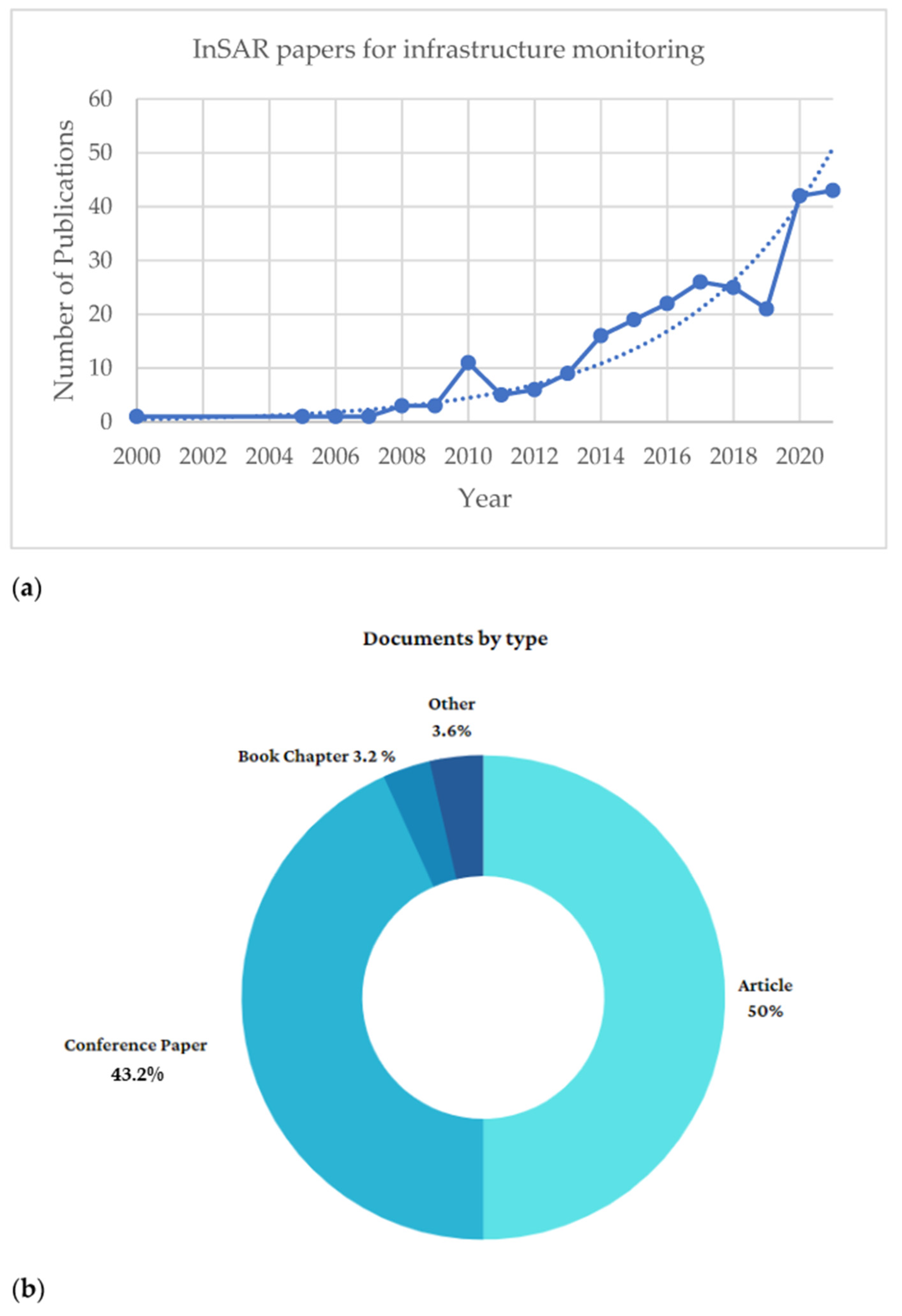
Figure 1. (a) Scientific contributions per year related to the applications of InSAR to infrastructure monitoring. (b) Documents by type. Source: Scopus (www.scopus.com), accessed on 1 September 2022 [36].
Remotesensing 15 00418 g001
Figure 2. Citation overview of the selected papers related to MT-InSAR for infrastructure monitoring.
Remotesensing 15 00418 g002
Figure 3. Maintenance strategies overview, SS-EN 13306 (2001) [47].
Remotesensing 15 00418 g003
Figure 4. Maintenance overview: an example of the corrective, preventive, predictive and CBM approaches, SS-EN 13306 (2001) [47].
Remotesensing 15 00418 g004
Figure 5. Side-looking satellite SAR data acquisition: (a) antenna illumination footprint; (b) sequence of acquisitions over the same area (master and slave images).
Remotesensing 15 00418 g005
Figure 6. Scheme of the displacement detection by the PSI technique through n images collected on the same area: Ri is the sensor–to-target distance of the ith acquisitions, ΔRi is the variation with respect to the previous image.
Remotesensing 15 00418 g006
Figure 7. Processing steps of the persistent scatterer interferometry analysis.
Remotesensing 15 00418 g007
Figure 8. Schematic overview of the processing steps of the PS technique.
Remotesensing 15 00418 g008
Figure 9. Overview of the SAR satellite missions taking place from 1992 to 2022.
Remotesensing 15 00418 g009
Figure 10. CSK/CSG current orbital configuration.
Remotesensing 15 00418 g010
Figure 11. Comparison of SAR imaging types supported by CSK (orange)/CSG (blue), source ASI: Italian Space Agency [80].
Remotesensing 15 00418 g011
Figure 12. Integrated monitoring of railways through InSAR and GPR technologies, modified from [17]. GPR B-scan data collected at 0–100 m, 100–200 m and 200–300 m railway sections, showing signal attenuation (dashed orange boxes) at the subsidence sections detected by InSAR (PSs in red).
Remotesensing 15 00418 g012
Figure 13. Integrated monitoring of runways through Sentinel-1 SAR products processed by MT-InSAR and interpolated by geostatistical methods and levelling, modified from [108]. Displacement velocity trends of the Sentinel-1 PSI data interpolated by a Kriging geostatistical approach (red cross markers) and longitudinal survey profiles (ae) by topographic levelling (blue squared markers); (f) scatter plot of the interpolated Sentinel-1 and levelling deformations, with regression line.
Remotesensing 15 00418 g013
Figure 14. Flowchart of the proposed integrated health monitoring model for transport infrastructure management.
Remotesensing 15 00418 g014
Table 1. Non-destructive testing (NDT) methods and sensors used in transport infrastructure monitoring.
NDT TechnologyDescriptionReferences
AccelerometersAccelerometers can record three-dimensional movement and could potentially be used to remotely monitor cattle behaviour. These devices collect data based on pre-defined recording intervals called epochs. Accelerometers are one type of sensor used to measure the vibration on bridge decks[2,21,22]
Strain GaugesStrain gauges are used to measure strains on target objects. Generally, strain gauges consist of an insulating flexible backing supporting a metallic foil pattern. As the object is deformed, the foil is deformed, causing its electrical resistance to change[3,23]
Wireless Network SystemsData collected by wireless network monitoring systems allow identification of modal frequencies and mode shapes of bridges[24]
Infrared ThermographyThis technique is based on a process where heat at any temperature is converted into a thermal image using specialised scanning cameras[25,26]
Laser ScannerThe laser scanner, also referred to as LiDAR, is used for 3D data acquisition of both topographic and close-range objects. The equipment allows for an automated dense sampling of the object surface within a short time range[9,10,27]
Global Positioning System (GPS)One of the global navigation satellite systems (GNSS) provides geolocation and time information to a GPS receiver anywhere on or near the Earth where there is an unobstructed line of sight to four or more GPS satellites[4]
Ground-Penetrating Radar (GPR)The energy reflected by dielectric discontinuities in the subsurface is recorded through a receiving antenna and it is subsequently processed and displayed through a display unit[6,7,8,28,29]
Core DrillingGeometric information on the internal configuration of the structure (i.e., bridges) are provided from the material extracted. Cores are visually analysed to collect information about layer thickness and hollow sections, amongst others[30,31]
Sonic TomographyThis technique is an improvement of the sonic transmission test method, as tests are performed along paths non-perpendicular to the wall surface, as well as in a direct mode[32,33]
Table 2. PSI Applications: Stand-alone use of satellite technology for transport infrastructure monitoring.
Roadways,
Highways
Research
Motivation
InnovationReferences
Road network monitoringIntegration of an automated PSI processing chain and GIS to extract vertical deformations in urban road networks[84]
Subsidence
monitoring and
displacement mapping
PSI to extract LOS deformations from road infrastructure assets[85,86,87,88,89,90]
Bridges
Health
monitoring
Extended PSI to extract linear and seasonal components of bridge deformations/comparison with levelling measurements/model thermal and structural deformations [91,92,93,94,95,96,97,98]
Pre-failure assessmentPSI to evaluate possible pre-failure bridge deformations[99,100,101,102]
Airport runways
Runway displacement mappingDisplacement evaluation on runways[103,104,105,106]
Subsidence monitoringGeostatistical analysis on PSI and comparison with levelling data[107,108]
Railways
Health
monitoring
Multi-geometry PSI to extract railway vertical/transversal deformations[109,110]
Displacement
monitoring
Comparison between PSI-based railway LOS deformations and temperature data[111]
Disclaimer/Publisher’s Note: The statements, opinions and data contained in all publications are solely those of the individual author(s) and contributor(s) and not of MDPI and/or the editor(s). MDPI and/or the editor(s) disclaim responsibility for any injury to people or property resulting from any ideas, methods, instructions or products referred to in the content.